Embed Size (px)
Citation preview
Republic of Haiti Ministry of Planning and External Cooperation (MPCE)
Urgent Rehabilitation and
Reconstruction Support Project
for Republic of Haiti
Final Report
(Summary)
November 2011
Japan International Cooperation Agency (JICA)
Yachiyo Engineering Co., Ltd.
EID
JR
11-134

Exchange rate (average rate (TTS): 6-month average from May 2010 to Oct 2010) US$1.00 = JPY88.00 US$1.00 = HTG (Haitian Gourde) 40.00 (Data from Bank of Tokyo-Mitsubishi UFJ)

Preface
Japan International Cooperation Agency (JICA) decided to conduct the Urgent Rehabilitation and
Reconstruction Support Project for the Republic of Haiti and entrust the project to Yachiyo
Engineering Co., Ltd.
The survey team held a series of discussions with the officials concerned of the Government of
the Republic of Haiti, and conducted field investigations. As a result of further studies in Japan, the
present report was finalized.
I hope that this report will contribute to the promotion of the project and to the enhancement of
friendly relations between our two countries.
Finally, I wish to express my sincere appreciation to the officials concerned of the Government of
the Republic of Haiti for their close cooperation extended to the survey team.
November, 2011
Kiyofumi Konishi
Director General,
Economic Infrastructure Development Department
Japan International Cooperation Agency

Urgent Rehabilitation and Reconstruction Support Project for Republic of Haiti
Final Report (Summary)
Contents
Preface Contents Location map Photos List of abbreviations Background Research flow A. Assistance for the formulation of Basic Plan for National Land Development .................................... A-1
1 Background ....................................................................................................................................... A-1
2 Basic conditions for the Basic Plan for National Land Development .............................................. A-2
3. Preliminary study with disasters taken into consideration ............................................................... A-4
4. Suggestion of items to be included in the Basic Plan for National Land Development .................. A-6
5. Recommendations ......................................................................................................................... A-17
B. Development of the Léogâne Commune Disaster Recovery Plan ...................................................... B-1
1. Current state of Léogâne Commune ................................................................................................ B-1
2. Policy for the development of the disaster recovery plan ................................................................ B-1
3. Framework for the plan (Ttarget year 2020) ................................................................................... B-3
4. Zoning of Léogâne Commune ......................................................................................................... B-3
5. Land use plan in Léogâne City (Ville de Léogâne) ......................................................................... B-5
6. Designation of zones for disaster recovery ...................................................................................... B-8
7. Infrastructure and public facility plan ............................................................................................ B-10
8. Building administration improvement plan ................................................................................... B-14
9. Agricultural sector development plan ............................................................................................ B-14
10. Disaster reduction plan ................................................................................................................ B-15
11. Project implementation plan ........................................................................................................ B-17
12. Recommendations ....................................................................................................................... B-19
C. Rehabilitation project planning ......................................................................................................... C1-1
C1 Consideration of rehabilitation project planning ............................................................................. C1-1
1. Consideration of priority rehabilitation projects (list of priority rehabilitation projects) .......... C1-1
2. Evaluation of rehabilitation projects .......................................................................................... C1-1
3. Priority rehabilitation projects ................................................................................................... C1-1
C2 Project for Improvement of Urban Roads and Drainage for the Reconstruction of Léogâne City ..... C2-1
1. Background, history and outline of the project .......................................................................... C2-1
2. Construction period and estimated construction cost .................................................................... C2-4
3. Project evaluation .......................................................................................................................... C2-5
D. Urgent Rehabilitation Project of Water Supply for Léogâne City Center .......................................... D-1
1. Position of the Project for Urgent Rehabilitation of the Water Supply System ........................... D-1
2. Current state of the sites for the urgent rehabilitation project ...................................................... D-1
3. Status of water use and existing water supply facilities ............................................................... D-1
4. Selection of urgent rehabilitation projects ................................................................................... D-2
5. Investigation of social and natural conditions .............................................................................. D-3
6. Planning and design of Urgent Rehabilitation Project of Water Supply for Léogâne City Center ..... D-5
7. Contents of the rehabilitation works .......................................................................................... D-11
8. Hygiene education activities ...................................................................................................... D-13
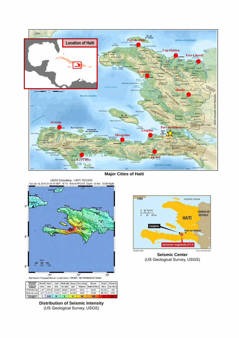
Major Cities of Haiti
Seismic Center (US Geological Survey, USGS)
Distribution of Seismic Intensity (US Geological Survey, USGS)
ハイチ国
Location of
Haiti
Port-au-Prince Léogâne
Jacmel
Miragoâne
Les Cayes
Jérémie
Gonaïves
Port-de-Paix
Cap-Haïtien Fort-Liberté
Hinche
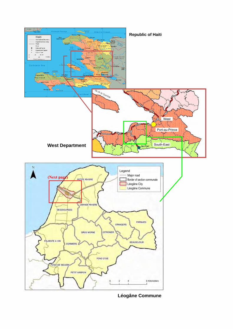
Location of Haiti
緊急リハビリ事業に係る整備区分図
West Department
Léogâne Commune
(Next page)
West
South-East
Port-au-Prince
Legend Major road
Léogâne City
Léogâne Commune
Republic of Haiti
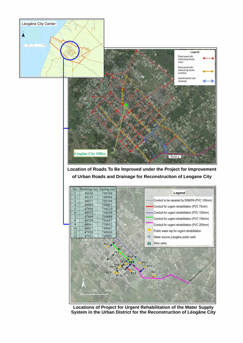
Location of Roads To Be Improved under the Project for Improvement
of Urban Roads and Drainage for Reconstruction of Leogane City
Locations of Project for Urgent Rehabilitation of the Water Supply System in the Urban District for the Reconstruction of Léogâne City
N
緊急リハビリ管路(PVC100mm)
水源(レオガン公共井戸)
緊急リハビリ公共水栓
凡例
緊急リハビリ管路(PVC150mm)
DINEPAによる補修管路(PVC100mm)
緊急リハビリ管路(PVC200mm)
PT. 3
PT. 1
PT. 5
PT. 4
仕切弁
0 500m 250
PT.7
PT. 2
PT. 6
PT. 8 PT. 9
PT. 10
PT. 11 PT. 12
緊急リハビリ管路(PVC75mm)
No. Northing (m) Easting (m)1 48420 7497602 48253 7499843 48077 7503494 48099 7504215 47954 7502106 48372 7501597 47908 7506888 48329 7500579 48061 750032
10 48037 74998311 47929 74993912 47932 749891
Nation
al Ro
ad R
t.2
Léogâne City Office
Léogâne City Center
Legend
Road paved with interlocking blocks (new)
Road paved with interlocking blocks (existing)
Asphalt-paved road
(restored)
Route 2
Conduit to be repaired by DINEPA (PVC 100mm)
Conduit for urgent rehabilitation (PVC 75mm)
Conduit for urgent rehabilitation (PVC 100mm)
Conduit for urgent rehabilitation (PVC 150mm)
Conduit for urgent rehabilitation (PVC 200mm)
Public water tap for urgent rehabilitation
Water source (Léogâne public well)
Slice valve
Legend
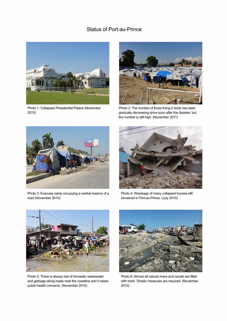
Status of Port-au-Prince
Photo 1: Collapsed Presidential Palace (November 2010)
Photo 2: The number of those living in tents has been gradually decreasing since soon after the disaster, but the number is still high. (November 2011)
Photo 3: Evacuee camp occupying a central reserve of a road (November 2010)
Photo 4: Wreckage of many collapsed houses still remained in Port-au-Prince. (July 2010)
Photo 5: There is always lots of domestic wastewater and garbage along roads near the coastline and it raises public-health concerns. (November 2010)
Photo 6: Almost all natural rivers and canals are filled with trash. Drastic measures are required. (November 2010)
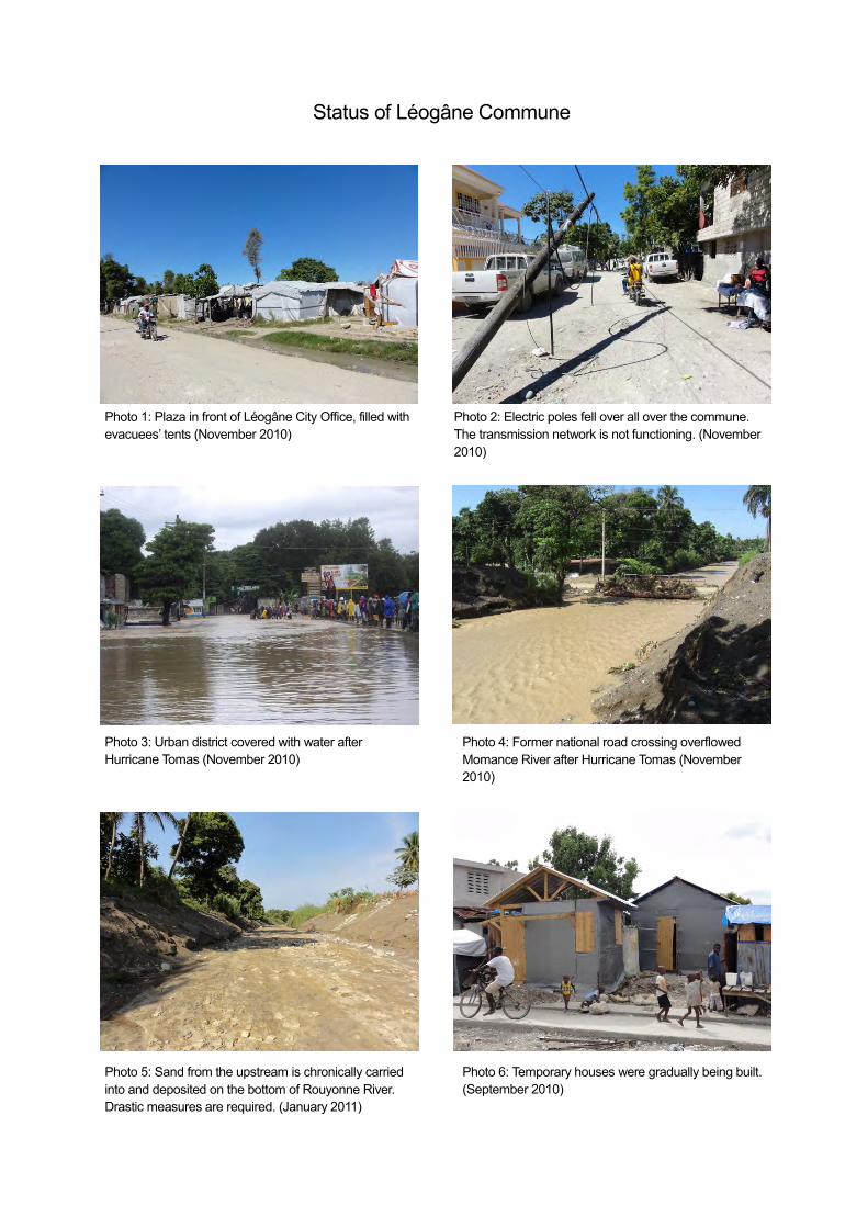
Status of Léogâne Commune
既存インターロッキングブロック舗装と瓦礫 既存インターロッキングブロック舗装と堆積した瓦礫
Photo 1: Plaza in front of Léogâne City Office, filled with evacuees’ tents (November 2010)
Photo 2: Electric poles fell over all over the commune. The transmission network is not functioning. (November 2010)
Photo 3: Urban district covered with water after Hurricane Tomas (November 2010)
Photo 4: Former national road crossing overflowed Momance River after Hurricane Tomas (November 2010)
Photo 5: Sand from the upstream is chronically carried into and deposited on the bottom of Rouyonne River. Drastic measures are required. (January 2011)
Photo 6: Temporary houses were gradually being built. (September 2010)
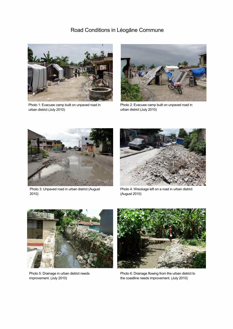
Road Conditions in Léogâne Commune
Photo 1: Evacuee camp built on unpaved road in urban district (July 2010)
Photo 3: Unpaved road in urban district (August 2010)
Photo 4: Wreckage left on a road in urban district (August 2010)
Photo 5: Drainage in urban district needs improvement. (July 2010)
既存インターロッキングブロック舗装と瓦礫 既存インターロッキングブロック舗装と堆積した瓦礫
Photo 2: Evacuee camp built on unpaved road in urban district (July 2010)
Photo 6: Drainage flowing from the urban district to the coastline needs improvement. (July 2010)
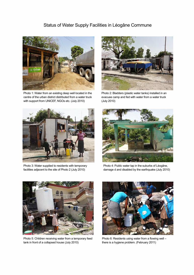
Status of Water Supply Facilities in Léogâne Commune
既存インターロッキングブロック舗装と瓦礫 既存インターロッキングブロック舗装と堆積した瓦礫
Photo 1: Water from an existing deep well located in the centre of the urban district distributed from a water truck with support from UNICEF, NGOs etc. (July 2010)
Photo 2: Bladders (plastic water tanks) installed in an evacuee camp and fed with water from a water truck (July 2010)
Photo 3: Water supplied to residents with temporary facilities adjacent to the site of Photo 2 (July 2010)
Photo 4: Public water tap in the suburbs of Léogâne, damage d and disabled by the earthquake (July 2010)
Photo 5: Children receiving water from a temporary feed tank in front of a collapsed house (July 2010)
Photo 6: Residents using water from a flowing well – there is a hygiene problem. (February 2011)
List of Abbreviations (1)
Abbreviationin French French Abbreviation
in English English
AAN Administration Aéroportuaire Nationale National Airport AuthorityACDI Agence Canadienne de Développement
InternationalCIDA Canadian International Development Agency
ACTED Agence d'Aide à la Coopération Technique Etau Développement
Agency for Technical Cooperation andDevelopment
AEP Alimentation en eau potable Water SupplyAEPA Approvisionnement en Eau Potable et
AssainissementWater Supply and Sanitation
AFD Agence Française de Développement French Development AgencyAGD Administration Générale des Douanes General Administration of CustomsAMPAP Aire Métropolitaine de Port-au-Prince Metropolitan Area of Port-au-PrinceAPN Autorité Portuaire Nationale National Port AuthorityASEC Assemblée de la Section Communale Assembly of Section CommunaleBHDA Bureau Haïtien du Droit d'Auteur Haitian Bureau of Copyright
Besoins Humains Fondamentaux BHN Basic Human NeedsBID Banque Interaméricaine de Développement IDB (IADB) Inter-American Development BankBM Banque Mondiale WB World BankBMAE Bureau de Monetisation de l’Aide Externe Bureau de Monetisation de l’Aide ExterneBMD Banques Multilatérales de Développement MDB Multilateral Development Bank
BNE Bureau National d'Ethnologie National Bureau of EthnologyBRH Banque de la République d’Haïti Bank of Republic of HaitiCAEPA Comité d’Approvisionnement en Eau Potable et
AssainissementWater Supply and Sanitation Committee
CAMEP Centrale Autonome Métropolitaine d'EauPotable
Metropolitan Autonomous Center of Water
CARICOM Communauté Caribéenne CARICOM Caribbean CommunityCASEC Conseil d'Administration de Section
CommunaleBoard of Directors of Section Communale
CCR Centre Commun de Recherche JRC Joint Research CenterCENAPRED Centro Nacional de Prevención de Desastres
(espagnol / Mexique)CENAPRED Centro Nacional de Prevención de Desastres
(spanish / Mexico)CEP Conseil Électoral Permanent (ou Provisoire) Permanent (or Provisional) Electoral Council
CIA Agence centrale de renseignement CIA Central Intelligence AgencyCIP Conseil Inter-Départemental Inter-Departmental CouncilCEPALC Commission Économique Pour l'Amérique
latine et les CaraïbesECLAC United Nations Economic Commission for
Latin America and the CaribbeanCFI Centre de Facilitation des Investissements Investment Facilitation CenterCIAT Comité Interministériel d'Aménagement du
TerritoireInterministerial Committee for TerritorialPlanning
CIRH Commision Intérimaire pour Reconstructiond'Haïti
IHRC Interim Hati Recovery Commission
CMMP Commission Ministérielle des Marchés Publics Ministerial Commission for Public ProcurementCNC Conseil National des Cooperatives National Council of CooperativesCNE Centre National d'Équipements National Center of FacilitiesCNIGS Centre National de l'Information Géo-Spatiale National Center for Geo-Spatial InformationCNMP Commission Nationale des Marchés Publics National Commission on Government
ProcurementCNSA Coordination Nationale de la SécuritéAlimentaire
National Coordination of Food Security
CONATEL Conseil National de Télécommunications National Council of TelecommunicationsCPE Comité de Point d'Eau Committee of Water Point
CSCCA Cour Supérieure des Comptes et duContentieux Administratif
Superior Court of Auditors and AdministrativeLitigation
CSPJ Conseil Supérieur du Pouvoir Judiciaire Supreme Council of Judicial PowerCTPEA Centre de Techniques de Planification et
d’Économie AppliquéeTechnical Centre of Planning and AppliedEconomics
CTE Centre Technique d'Exploitation Operation Technical CenterCURL Cellule d'Urgence pour la Reconstruction de
LéogâneDAAB Direction des Affaires Administratives et du
BudgetDepartment of Administrative Affairs andBudget
DATDLR Direction de l’Aménagement du Territoire, deDéveloppement Local et Régional
Directorate of Planning, Local and RegionalDevelopment
DCE Direction de Coopération Externe Directorate of External CooperationDDA Direction Departementale d’Artibonite Departmental Direction of ArtiboniteDDC Direction Departementale du Centre Departmental Direction of CenterDDGA Direction Departementale de La Grande-Anse Departmental Direction of Grande-AnseDDN Direction Departementale du Nord Departmental Direction of NorthDDNE Direction Departementale du Nord-Est Departmental Direction of North-EastDDNIPPES Direction Departementale des Nippes Departmental Direction of NippesDDNO Direction Departementale du Nord-Ouest Departmental Direction of North-West
List of Abbreviations (2)
Abbreviationin French French Abbreviation
in English English
DDO Direction Departementale de L’Ouest Departmental Direction of WestDDS Direction Departementale du Sud Departmental Direction of SouthDDSE Direction Departementale du Sud-Est Departmental Direction of South-EastDGDZF Direction Générale des Zones Franches General Directorate of Free ZonesDGI Direction Générale des Impôts Directorate General of TaxesDINEPA Direction Nationale de l'Eau Potable et de
l'AssainissementNational Directorate of Water and Sanitation
DIP Direction d’Investissement Publique Directorate of Public InvestmentDNL Direction Nationale du Livre National Office for BookDPC Direction de la Protection Civile Civil Protection DirectorateDPES Direction de Programmation Économique et
SocialDirectorate of Social and EconomicProgramming
DRH Direction des Ressources Humaines Directorate of Human ResourcesDSNCRP Document de Stratégie de Réduction de la
PauvretéStrategy Paper for Poverty Reduction
EBRI Évaluation des besoins de relèvement immédiat Assessing needs for immediate rehabilitationCommission Européenne EC European Commission
EDH Électricité d'Haïti Electricity of HaitiEMA École de la Magistrature School of MagistratesENAP École Nationale d'Administration et de
Politiques PubliquesNational School of Administration and PublicPolicy
ENARTS École Nationale des Arts National Art SchoolEPA Eau Potable et Assainissement WATSAN Water and SanitationEPT Education Pour Tous EFA Education For AllFAES Fonds d'Assistance Économique et Social Economic and Social Assistance FundFAO Organisation des Nations Unies pour
l'Alimentation et l'AgricultureFAO Food and Agriculture Organization of the
United NationsFIC Fonds d'Investissement Climatiques CIF Climate Investment FundFMI Fonds Monétaire International IMF International Monetary FundGATT Accord Général sur les Tarifs Douaniers et le
CommerceGATT General Agreement on Trade and Tariffs
GRD Gestion des Risques et des Désastres Risk and Disaster ManagementHIMO Haute Intensité de Main d'Œuvre High intensity of laborIDH Indice de Développement Humain HDI Human Development Index
Déplacés Internes IDP Internally Displaced PersonsIHSI Institut Haïtien de Statistiques et d'Informatique Haitian Institute of Statistics and Informatics
Institut Interméricain de Coopération pourl’agriculture
IICA Inter-American Institute for Cooperation onAgriculture
INARA Institut National de la Réforme Agraire National Institute of Agrarian ReformIPH Indice de la Pauvreté Humaine HPI The Human Poverty IndexISPAN Institut de Sauvegarde du Patrimoine National Institute for the Protection of National HeritageJICA Agence Japonaise de Coopération
InternationaleJICA Japan International Cooperation Agency
MARNDR Ministère de l'Agriculture, des RessourcesNaturelles et du Développement Rural
Ministry of Agriculture, Natural Resources andRural Development
MAST Ministère des Affaires Sociales et du Travail Ministry of Social Affairs and LaborMCFDF Ministère à la Condition Féminine et aux Droits
de la FemmeMinistry of Women's Status and Rights ofWomen
MCI Ministère du Commerce et de l'Industrie Ministry of Trade and IndustryMDE Ministère de l'Environnement Ministry of EnvironmentMEF Ministère de l'Economie et des Finances Ministry of Economy and FinanceMENFP Ministère de l'Education Nationale et de la
Formation ProfessionnelleMinistry of National Education and VocationalTraining
MICT Ministère de l'Intérieur et des CollectivitésTerritoriales
Ministry of Interior and Local Authorities
MINUSTAH Mission des Nations Unies pour la stabilisationen Haïti
United Nations Stabilization Mission in Haiti
MJSAC Ministère de la Jeunesse, des Sports et àl'Action Civique
Ministry of Youth, Sports and Civic Action
MJSP Ministère de la Justice et de la SécuritéPublique
Ministry of Justice and Public SecurityMPCE Ministère de la Planification et de la
Coopération ExterneMinistry of Planning and External Cooperation
MSPP Ministère de la Santé Publique et de laPopulation
Ministry of Public Health and Population
MTPTC Ministère des Travaux Publics, Transports etCommunications
Ministry of Public Works, Transport andCommunication
ND Non Disponible N.A. Not AvailableAssociation à but non Lucratif NPO Non-profit Organization
OCHA Bureau de la coordination des affaireshumanitaires
OCHA /UNOCHA
United Nations Office for the Coordination ofHumanitarian Affairs
OFATMA Office d'Assurance Travail, Maladie etMaternité
Office of Labor Insurance, Sickness andMaternity
OIM Organisation Internationale pour les Migrations IOM International Organization for MigrationOIT Organisation Internationale du Travail ILO International Labor Organization
List of Abbreviations (3)
Abbreviationin French French Abbreviation
in English English
OMRH Office de Management et des RessourcesHumaines
Office of Management and Human Resources
OMS Organisation Mondiale de la Santé WHO World Health OrganizationONA Office National d'Assurance Vieillesse Nation Office of Old-Age InsuranceONACA Office National du Cadastre National Office of CadastreONEV Observatoire National de l'Environnement et de
la VulnérabilitéNational Observatory for Environment andVulnerability
ONG Organisation Non Gouvernementale NGO Non-Governmental OrganizationsONI Office National d'Identification National Identification OfficeONPES Observatoire Nationale de la Pauvrete et de
l’Exclusion SocialNational Observatory of Poverty and SocialExclusion
OP Opérateurs Privés (ou Professionnels) Private (or Professional) Operators
OPC Office de Protection du Citoyen Office of Citizen DefenseOREPA Offices Régionaux de l’Eau Potable et de
l’AssainissementRegional Offices for Water and Sanitation
PAM Programme Alimentaire Mondial des NationsUnies
WFP World Food Programme
PAP (PaP) Port-au-Prince Port-au-PrincePARDH Plan d'Action pour le relèvement et le dé
veloppment d'HaïtiAction Plan for National Recovery andDevelopment of Haiti
PDNA Évaluation des Besoins Après Désastres PDNA Post Disaster Needs AssessmentPIB Produit Intérieur Brut GDP Gross Domestic ProductPNGRD Plan National de Gestion des Risques et des
DésastresNational Plan for Risk and DisasterManagement
PNH Police Nationale d'Haïti National Police of HaitiPNUD Programme des Nations Unies pour le
DéveloppementUNDP United Nations Development Programme
PNUEH/ONU-Habitat
Programme des Nations Unies pour lesÉtablissements Humains
UN-HABITAT
United Nations Human Settlement Programme
POCHEP Poste Communautaire d’Hygiène et d’Eaupotable
Community Post of Water and Hygiene
PRSP Document de stratégie nationale pour lacroissance et pour la réduction de la pauvreté
PRSP Poverty Reduction Strategy Paper
RNB Revenu National Brut GNI Gross National IncomeRNH Radio Nationale d'Haïti National Radio of HaitiSAEP Système d’ Approvisionnement en Eau Potable Water Supply SystemSAP Système d'Alerte Précoce Early Warning SystemSEMANAH Service Maritime et de Navigation d'Haïti Maritime and Navigation Service in HaitiSMCRS Service Métropolitain de Collecte des Résidus
SolidesService Metropolitan Solid Waste Collection
SNAT Schéma Narional d'Aménagement du Territoire National Territorial Development Plan
SNEP Service National d'Eau Potable National Water Service
SNGE Système National de Gestion del'Environnement
National System of Environmental Management
SNGRD Système National de Gestion des Risques etdesDésastres
National System for Risk and DisasterManagement
SPGRD Secrétariat Permanent de Gestion des Risqueset Désastre
StC Save the Children StC Save the ChildrenTCA Taxe sur le Chiffre d'Affaires Tax on TurnoverTELECO Télécommunications d'Haïti SAM Telecommunications of Haiti SAMTIC Technologies de l'Information et des
TélécommunicationsTechnology for Information andTelecommunications
TNH Télévision Nationale d'Haïti National Television of HaitiUCAONG Unité de Coordination des Activites des
Organisation Non GouvernementalesCoordination Unit of activities of Non-Governmental Organization
UCDD Unité de Coordination des DirectionsDépartementales
Coordination Unit of Departmental Directorates
UE Union Européenne EU European UnionUNICEF Fonds des Nations Unies pour l'Enfance UNICEF United Nations Children’s FundURD Unité Rurale Départementale Departmental Rural Unit
URSEP Unité Reforme du Secteur Eau Potable Water Sector Reform UnitUSAID Agence des États-Unis pour le Développement
InternationalUSAID United States Agency for International
DevelopmentUSE Unite de Suivi et d’Évaluation Unite Monitoring and Evaluation

Background
On January 12, 2010, a massive earthquake of magnitude 7.0 struck the capital region of the Republic of Haiti. The damage caused by collapsed buildings was enormous, with over 230,000 dead and missing, over 310,000 injured, and approx. 1.5 million people afflicted.
To respond to this disaster, the government of Haiti and the international society established the Interim Haiti Recovery Commission (IHRC), and at the New York donor conference on March 31, 2010, the donors pledged a total of over 5 billion US dollars. The Haitian government has also established the Action Plan for National Recovery and Development of Haiti, March 2010, conducting reconstruction activities.
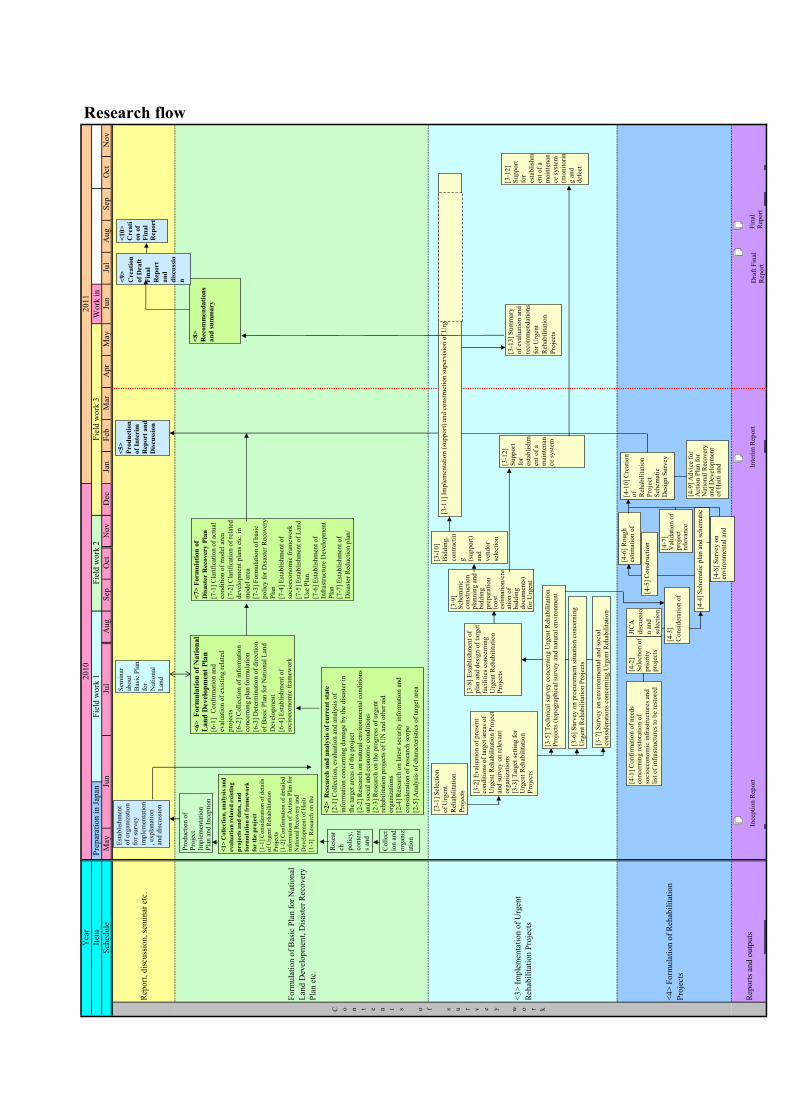
At the request of the Haitian government, JICA carried out the Urgent Rehabilitation and Reconstruction Support Project for Haiti from May 2010 to August 2011 for prompt rehabilitation and reconstruction after the disaster. The details of the cooperation are as described below.
(1) Assistance for the formulation of the Basic Plan for National Land Development: Based on the Action Plan for National Recovery and Development of Haiti and experience in
Japan, we provided assistance for the formulation of the Basic Plan for National Land Development, mainly for disaster reduction, decentralization and localization.
(2) Development of Léogâne Commune Disaster Recovery Plan: We proposed a disaster recovery plan for Léogâne Commune, a heavily-damaged area near the
capital, that takes into consideration the development of a regional core area that will contribute to decentralization and also the development of a city well-prepared against disasters.
(3) Rehabilitation project planning: We conducted schematic design study for the Project for Improvement of Urban Roads and
Drainage for the Reconstruction in Léogâne City, which has been selected as a result of needs assessment concerning infrastructure reconstruction projects to support quick reconstruction of social and economic infrastructure.
(4) Urgent rehabilitation projects (implementation of an urgent rehabilitation project for the reconstruction of basic infrastructure): We conducted needs assessment, selection of target projects, planning, design and construction for Urgent Rehabilitation Project of Water Supply for Léogâne City Center, as an urgent rehabilitation project to rebuild basic infrastructure and people's lives in the disaster-stricken area.
In the rehabilitation projects and urgent rehabilitation projects, improvement of livelihoods through
employment of local residents etc. and promotion of health through improvement of hygienic environment were taken into consideration.
The Project for Improvement of Urban Roads and Drainage for the Reconstruction in Léogâne City, proposed in the above (3), is now being implemented after the Exchange of Notes for Grant Aid was signed between Haitian and Japanese governments in November 2010 and the procurement agency agreement was signed in March 2011.
Urgent Rehabilitation Project of Water Supply for Léogâne City Center, described in the above (4), was completed in May 2011, including some additional expansion works. Defect inspection was conducted in October 2011.

Restrictions of the Project
As Haiti experienced this massive earthquake in January 2010 after long years' of political turmoil and repeated attacks by large hurricanes in 2008, the Project was prepared with very limited data due to scattering of existing documents etc. The country experienced a marked shortage in funds and human resources even before the disaster, but the disaster further weakened the administrative ability, destroying many important facilities and taking many precious human resources. The organizations of local governments are even weaker and can hardly function properly. In this situation, assumptions have to be made based on old data and the data collected this time, as other accurate data is not available. Attention needs to be paid not only to this, but to the possibility that the current states have largely changed after the disaster.
Rep
ort,
disc
ussi
on, s
emin
ar e
tc.
Form
ulat
ion
of B
asic
Pla
n fo
r Nat
iona
lLa
nd D
evel
opm
ent,
Dis
aste
r Rec
over
yPl
an e
tc.
<3>
Impl
emen
tatio
n of
Urg
ent
Reh
abili
tatio
n Pr
ojec
ts
<4>
Form
ulat
ion
of R
ehab
ilita
tion
Proj
ects
Rep
orts
and
out
puts
2011
Apr
May
Research flowJu
nJu
lA
ugSe
pO
ctN
ovSc
hedu
leA
ugSe
pO
ctM
ayJu
nJu
lW
ork
inFe
bM
arN
ovD
ecJa
n
Yea
rIte
m
C o n t e n t s o f s u r v e y w o r k
2010
Prep
arat
ion
in Ja
pan
Fiel
d w
ork
1Fi
eld
wor
k 2
Fiel
d w
ork
3
▲
▲
▲
▲
Esta
blis
hmen
t of
org
aniz
atio
n fo
r sur
vey
impl
emen
tatio
n, e
xpla
natio
n an
d di
scus
sion
<1
> C
oll
ecti
on
, a
na
lysi
s a
nd
eva
lua
tio
n r
ela
ted
exis
tin
g
pro
jects
an
d d
ata
, a
nd
form
ula
tio
n o
f fr
am
ew
ork
for t
he p
ro
ject
[1-1
] C
on
sid
erat
ion
of
det
ails
of
Urg
ent
Reh
abil
itat
ion
P
roje
cts
[1-2
] C
on
firm
atio
n o
f d
etai
led
in
form
atio
n o
f A
ctio
n P
lan
for
Nat
ion
al R
ecover
y a
nd
D
evel
op
men
t of
Hai
ti
[1-3
] R
esea
rch
on
th
e
Res
ear
ch
po
licy
,
con
ten
t
s an
d
Co
llec
t
ion
an
d
org
aniz
atio
n
Ince
ptio
n R
epor
t
Prod
uctio
n of
Pr
ojec
t Im
plem
enta
tion
Plan
and
Ince
ptio
n
<2
> R
esea
rch
an
d a
naly
sis
of
curr
ent
state
[2
-1]
Coll
ecti
on
, ev
aluat
ion
an
d a
nal
ysi
s o
f
info
rmat
ion
co
nce
rnin
g d
amag
e b
y t
he
dis
aste
r in
the
targ
et a
reas
of
the
pro
ject
[2-2
] R
esea
rch
on
nat
ura
l en
vir
on
men
tal
con
dit
ion
s an
d s
oci
al a
nd
eco
no
mic
co
nd
itio
ns
[2-3
] R
esea
rch
on
the
pro
gre
ss o
f u
rgen
t re
hab
ilit
atio
n p
roje
cts
of
UN
an
d o
ther
aid
o
rgan
izat
ion
s
[2-4
] R
esea
rch
on
lat
est
secu
rity
info
rmat
ion
an
d
con
sider
atio
n o
f re
sear
ch s
cop
e
[2-5
] A
nal
ysi
s o
f ch
arac
teri
stic
s o
f ta
rget
are
a
<6
> F
orm
ula
tio
n o
f N
ati
on
al
La
nd
Dev
elo
pm
en
t P
lan
[6
-1]
Co
nfi
rmat
ion
an
d
eval
uat
ion
of
exis
tin
g r
elat
ed
pro
ject
s
[6-2
] C
oll
ecti
on
of
info
rmat
ion
con
cern
ing p
lan
fo
rmu
lati
on
[6-3
] D
eter
min
atio
n o
f d
irec
tio
n
of
Bas
ic P
lan
fo
r N
atio
nal
Lan
d
Dev
elo
pm
ent
[6-4
] E
stab
lish
men
t o
f
soci
oec
on
om
ic f
ram
ewo
rk
Sem
inar
ab
out
Bas
ic P
lan
for
Nat
iona
l La
nd
Inte
rim R
epor
t
[3-1
] Sel
ectio
n of
Urg
ent
Reh
abili
tatio
n Pr
ojec
ts
[3-9
] Sc
hem
atic
co
nstru
ctio
n pl
anni
ng a
nd
bidd
ing
prep
arat
ion
(cos
t es
timat
ion/
cre
atio
n of
bi
ddin
g do
cum
ents
) fo
r Urg
ent
[3-7
] Sur
vey
on e
nviro
nmen
tal a
nd so
cial
co
nsid
erat
ions
con
cern
ing
Urg
ent R
ehab
ilita
tion
[3-8
] Est
ablis
hmen
t of
plan
and
des
ign
of ta
rget
fa
cilit
ies c
once
rnin
g U
rgen
t Reh
abili
tatio
n Pr
ojec
ts
[3-1
0]
Bid
din
g,
con
trac
tin
g
(su
pp
ort
)
and
ven
do
r
sele
ctio
n
[3-1
1] Im
plem
enta
tion
(sup
port)
and
con
stru
ctio
n su
perv
isio
n of
Urg
ent R
ehab
ilita
tion
Proj
ects
)
[3-1
3]
Su
mm
ary
of
eval
uat
ion
an
d
reco
mm
end
atio
ns
for
Urg
ent
Reh
abil
itat
ion
Pro
ject
s
[4-1
] C
on
firm
atio
n o
f n
eed
s co
nce
rnin
g r
esto
rati
on
of
soci
oec
on
om
ic i
nfr
astr
uct
ure
s an
d
list
of
infr
astr
uct
ure
s to
be
rest
ore
d
[4-2
] S
elec
tio
n o
f p
rio
rity
p
roje
cts
[4-1
0]
Cre
atio
n
of
Reh
abil
itat
ion
P
roje
ct
Sch
emat
ic
Des
ign S
urv
ey
[4-4
] S
chem
atic
pla
n a
nd
sch
emat
ic
[4-9
] A
dvic
e fo
r A
ctio
n P
lan
fo
r N
atio
nal
Rec
over
y
and
Dev
elo
pm
ent
of
Hai
ti a
nd
[4-5
] C
on
stru
ctio
n
[4-7
] V
alid
atio
n o
f p
roje
ct
rele
van
ce
[4-6
] R
ou
gh
es
tim
atio
n o
f
[4-8
] S
urv
ey o
n
envir
on
men
tal
and
<5>
Prod
uctio
n of
Inte
rim
R
epor
t and
D
iscu
ssio
n
<8
>
Rec
om
men
dati
on
s
an
d s
um
ma
ry
<9
>
Cre
ati
on
of
Dra
ft
Fin
al
Rep
ort
an
d
dis
cuss
io
n
<1
0>
C
reati
on
of
Fin
al
Rep
ort
<7
> F
orm
ula
tion
of
Dis
ast
er R
ecover
y P
lan
[7-1
] C
lari
fica
tio
n o
f ac
tual
con
dit
ion
of
mo
del
are
a
[7-2
] C
lari
fica
tio
n o
f re
late
d
dev
elo
pm
ent
pla
ns
etc.
in
mo
del
are
a
[7-3
] F
orm
ula
tio
n o
f b
asic
po
licy
fo
r D
isas
ter
Rec
over
y
Pla
n
[7-4
] E
stab
lish
men
t o
f
soci
oec
on
om
ic f
ram
ewo
rk
[7-5
] E
stab
lish
men
t o
f L
and
Use
Pla
n
[7-6
] E
stab
lish
men
t o
f
Infr
astr
uct
ure
Dev
elo
pm
ent
Pla
n
[7-7
] E
stab
lish
men
t o
f
Dis
aste
r R
edu
ctio
n p
lan
/
Dra
ft Fi
nal
Rep
ort
Fina
l R
epor
t
JIC
A
dis
cuss
io
n a
nd
sele
ctio
n
[3-1
2]
Supp
ort
for
esta
blis
hmen
t of a
m
aint
enan
ce sy
stem
[3-2
] Eva
luat
ion
of p
rese
nt
cond
ition
s of t
arge
t are
as o
f U
rgen
t Reh
abili
tatio
n Pr
ojec
t an
d su
rvey
on
rele
vant
or
gani
zatio
ns [3
-3] T
arge
t set
ting
for
Urg
ent R
ehab
ilita
tion
Proj
ects
[3-6
] Sur
vey
on p
rocu
rem
ent s
ituat
ion
conc
erni
ng
Urg
ent R
ehab
ilita
tion
Proj
ects
[3-5
] Tec
hnic
al su
rvey
con
cern
ing
Urg
ent R
ehab
ilita
tion
Proj
ects
(top
ogra
phic
al su
rvey
and
nat
ural
env
ironm
ent
[4-3
]
Co
nsi
der
atio
n o
f
[3-1
2]
Su
pp
ort
for
esta
bli
shm
ent
of
a
mai
nte
nan
ce s
yst
em
(mo
nit
ori
n
g a
nd
def
ect
A - 1
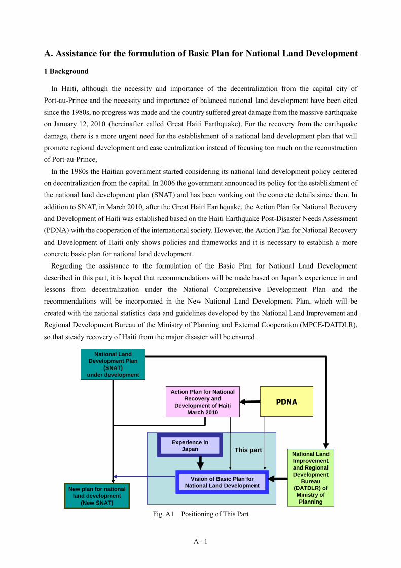
A. Assistance for the formulation of Basic Plan for National Land Development
1 Background
In Haiti, although the necessity and importance of the decentralization from the capital city of Port-au-Prince and the necessity and importance of balanced national land development have been cited since the 1980s, no progress was made and the country suffered great damage from the massive earthquake on January 12, 2010 (hereinafter called Great Haiti Earthquake). For the recovery from the earthquake damage, there is a more urgent need for the establishment of a national land development plan that will promote regional development and ease centralization instead of focusing too much on the reconstruction of Port-au-Prince,
In the 1980s the Haitian government started considering its national land development policy centered on decentralization from the capital. In 2006 the government announced its policy for the establishment of the national land development plan (SNAT) and has been working out the concrete details since then. In addition to SNAT, in March 2010, after the Great Haiti Earthquake, the Action Plan for National Recovery and Development of Haiti was established based on the Haiti Earthquake Post-Disaster Needs Assessment (PDNA) with the cooperation of the international society. However, the Action Plan for National Recovery and Development of Haiti only shows policies and frameworks and it is necessary to establish a more concrete basic plan for national land development.
Regarding the assistance to the formulation of the Basic Plan for National Land Development described in this part, it is hoped that recommendations will be made based on Japan’s experience in and lessons from decentralization under the National Comprehensive Development Plan and the recommendations will be incorporated in the New National Land Development Plan, which will be created with the national statistics data and guidelines developed by the National Land Improvement and Regional Development Bureau of the Ministry of Planning and External Cooperation (MPCE-DATDLR), so that steady recovery of Haiti from the major disaster will be ensured.
Fig. A1 Positioning of This Part
National Land
Development Plan
(SNAT)
under development
PDNA
New plan for national
land development
(New SNAT)
Vision of Basic Plan for
National Land Development
National Land
Improvement
and Regional
Development
Bureau
(DATDLR) of
Ministry of
Planning
Experience in
Japan This part
Action Plan for National
Recovery and
Development of Haiti
March 2010
National Land
Development Plan
(SNAT)
under development
PDNA
New plan for national
land development
(New SNAT)
Vision of Basic Plan for
National Land Development
National Land
Improvement
and Regional
Development
Bureau
(DATDLR) of
Ministry of
Planning
Experience in
Japan This part
Action Plan for National
Recovery and
Development of Haiti
March 2010
A - 2
2 Basic conditions for the Basic Plan for National Land Development (Action Plan for National Recovery and Development of Haiti and experience with decentralization in Japan)
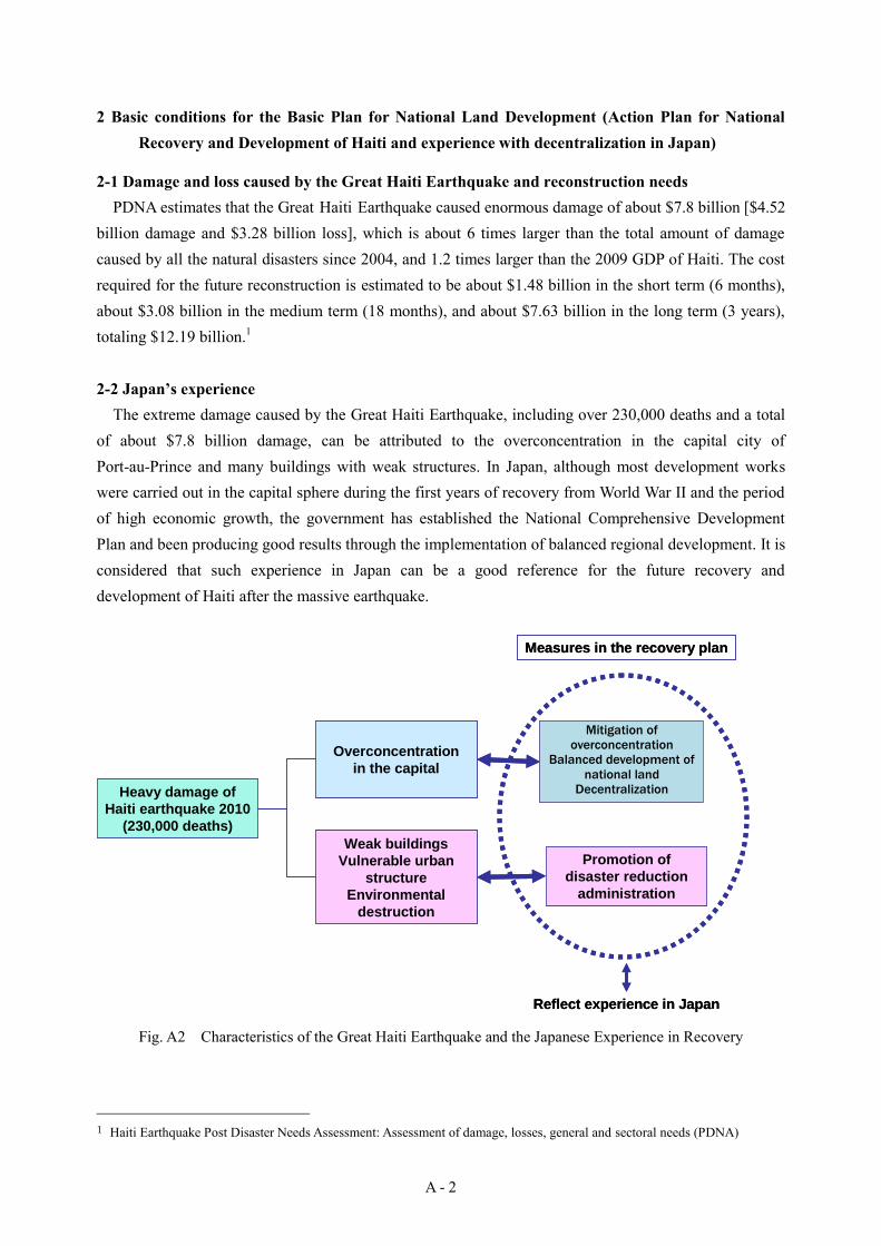
2-1 Damage and loss caused by the Great Haiti Earthquake and reconstruction needs PDNA estimates that the Great Haiti Earthquake caused enormous damage of about $7.8 billion [$4.52
billion damage and $3.28 billion loss], which is about 6 times larger than the total amount of damage caused by all the natural disasters since 2004, and 1.2 times larger than the 2009 GDP of Haiti. The cost required for the future reconstruction is estimated to be about $1.48 billion in the short term (6 months), about $3.08 billion in the medium term (18 months), and about $7.63 billion in the long term (3 years), totaling $12.19 billion.1 2-2 Japan’s experience
The extreme damage caused by the Great Haiti Earthquake, including over 230,000 deaths and a total of about $7.8 billion damage, can be attributed to the overconcentration in the capital city of Port-au-Prince and many buildings with weak structures. In Japan, although most development works were carried out in the capital sphere during the first years of recovery from World War II and the period of high economic growth, the government has established the National Comprehensive Development Plan and been producing good results through the implementation of balanced regional development. It is considered that such experience in Japan can be a good reference for the future recovery and development of Haiti after the massive earthquake.
Fig. A2 Characteristics of the Great Haiti Earthquake and the Japanese Experience in Recovery
1 Haiti Earthquake Post Disaster Needs Assessment: Assessment of damage, losses, general and sectoral needs (PDNA)
Heavy damage of
Haiti earthquake 2010
(230,000 deaths)
Overconcentration
in the capital
Weak buildings
Vulnerable urban
structure
Environmental
destruction
Mitigation of
overconcentration
Balanced development
of national land
Decentralization
Promotion of
disaster reduction
administration
Reflect experience in Japan
Measures in the recovery plan
Mitigation of overconcentration
Balanced development of
national land Decentralization
A - 3
2-3 Consideration for the recovery and development of Haiti As for Japan’s experience in reconstruction and development, we can say that it was effective to
establish a national land development plan and then establish and implement various infrastructure plans based on this. In Japan, emphasis was placed especially on the improvement of traffic infrastructure that connected major transportation bases in the country and also served as contact points with overseas countries, which significantly contributed to the subsequent economic development. River improvement and dam construction promoted through the establishment of flood control plans helped prevent flood damage and also improved agricultural productivity as it increased water usage. Electricity production was dramatically increased through the production of dams and it contributed to local industry development. Moreover, at the city level, planned land use helped contain damage from disasters and increase disaster-preparedness through the improvement of public space and facilities.
As described above, in order to carry out balanced development while easing overconcentration, it is essential to develop transportation, traffic and other social infrastructures in an integrated manner and establish a comprehensive development plan that provides the foundation for it. In Japan, various long-term plans concerning development of social infrastructures were developed as needed in combination with national land development plans, and development of public facilities based on such long-term plans helped industrial development, taking advantage of ports and other local characteristics. In Haiti, it is important to officially establish and carry out as soon as possible the national land development plan that is now being developed and to create related infrastructure development plans also at an early date.
Although there may be various problems looming during implementation, balanced development of national land can be expected with planned formulation of further national land development plans tailored to the recovery stage of Haiti after the Basic Plan for National Land Development, which the Haitian government is now developing, or with flexible and phased revision and improvement of the plan when needed.

A - 4
3. Preliminary study with disasters taken into consideration
3-1 Population Haitian Institute of Statistics and Information (IHSI) has forecasted population of each department till
2030 based on the national census of 2003. According to this, the population of 2030 is estimated to be 16.55 million.
Table A1 Population Forecasts (Unit: K people)
0
2,000
4,000
6,000
8,000
10,000
12,000
14,000
16,000
18,000
Pop
ulat
ion
(100
0)
South-east 485 531 566 604 644 687
South 622 664 697 730 766 803
West 3,097 3,899 4,597 5,419 6,388 7,531
North-w est 531 648 746 859 990 1,140
North-east 308 360 402 450 502 561
North 823 933 1,021 1,117 1,222 1,337
Grand'anse 627 680 720 763 808 856
Centre 582 680 761 851 952 1,065
Artibonite 1,299 1,567 1,791 2,046 2,339 2,673
2003 2010 2015 2020 2025 2030
Year 2003 2010 2015 2020 2025 2030
Haïti 8,374 9,962 11,300 12,839 14,611 16,653 (Ref.: IHSI, MPCE- DATDLR, 2010)
3-2 Status of industries According to the Ministry of Economy and Finance (MEF), the economic growth rate from 2005 to 2009
was 2-3%, slightly increasing, and reached 2.9% in 2009.In 2010 the growth rate dropped to -8.5% due to the damage by the Great Haiti Earthquake, but is expected to increase to 10.2% in 2011 with international support for recovery.
The economy of Haiti heavily depends on the support from the international society and money sent from Haitians living overseas (diaspora)2, and the country needs economic growth to support its recovery. It is hoped that the priority development fields defined in the Action Plan for National Recovery and Development of Haiti (construction, agriculture, processing of agricultural products, tourism and
2 Social circumstances, water supply and sanitation baseline survey by the research team (D Urgent Rehabilitation Projects 5-1), website of the U.S. Census Bureau (http://www.census.gov/) etc.
数値データの表整理追加 数値データの表整理追加
A - 5
industry) will grow.
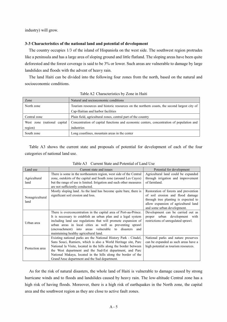
3-3 Characteristics of the national land and potential of development The country occupies 1/3 of the island of Hispaniola on the west side. The southwest region protrudes
like a peninsula and has a large area of sloping ground and little flatland. The sloping areas have been quite deforested and the forest coverage is said to be 3% or lower. Such areas are vulnerable to damage by large landslides and floods with the advent of heavy rain.
The land Haiti can be divided into the following four zones from the north, based on the natural and socioeconomic conditions.
Table A2 Characteristics by Zone in Haiti Zone Natural and socioeconomic conditions North zone Tourism resources and historic resources on the northern coasts, the second largest city of
Cap-Haitian and harbor facilities Central zone Plain field, agricultural zones, central part of the country West zone (national capital region)
Concentration of capital functions and economic centers, concentration of population and industries
South zone Long coastlines, mountain areas in the center
Table A3 shows the current state and proposals of potential for development of each of the four categories of national land use.
Table A3 Current State and Potential of Land Use Land use Current state and issues Potential for development
Agricultural land
There is some in the northeastern region, west side of the Central zone, outskirts of the capital and South zone (around Les Cayes) but the range of use is limited. Irrigation and such other measures are not sufficiently conducted.
Agricultural land could be expanded through irrigation and improvement of farmland.
Nonagricultural land
Mostly sloping land. As the land has become quite bare, there is significant soil erosion and loss.
Restoration of forests and prevention of soil erosion and flood damage through tree planting is expected to allow expansion of agricultural land and some urban development.
Urban area
There is overconcentration in the capital area of Port-au-Prince. It is necessary to establish an urban plan and a legal system including land use regulations that will promote expansion of urban areas in local cities as well as preventing sprawl (encroachment) into areas vulnerable to disasters and maintaining healthy agricultural land.
Development can be carried out as proper urban development with restrictions of unregulated sprawl.
Protection area
Existing national parks are the National History Park - Citadel, Sans Souci, Ramiers, which is also a World Heritage site, Parc National la Visite, located in the hills along the border between the West department and the Sud-Est department, and Parc National Makaya, located in the hills along the border of the Grand'Anse department and the Sud department.
National parks and nature preserves can be expanded as such areas have a high potential as tourism resources.
As for the risk of natural disasters, the whole land of Haiti is vulnerable to damage caused by strong hurricane winds and to floods and landslides caused by heavy rain. The low-altitude Central zone has a high risk of having floods. Moreover, there is a high risk of earthquakes in the North zone, the capital area and the southwest region as they are close to active fault zones.
A - 6
3-4 Purposes of the national land development plan (SNAT) The Ministry of Planning describes the following purposes of the establishment of the national land
development plan (SNAT) in its statement of policy for the establishment of SNAT.
For the improvement of people's living through the effective use of resources and balanced and harmonized development of all national land, the following purposes have been set.
Structuring of national land <development centers, axes, links, and nodes> Utilization of regional resources and potentials Environment preservation and effective utilization of resources Satisfaction of BHN of all people Establishment of comprehensive economic, regional and urban development strategies and
promotion of decentralization
The purpose of the establishment of SNAT is to achieve rational development of the national land through balanced local development and decentralization of the capital.
4. Suggestion of items to be included in the Basic Plan for National Land Development
4-1 Socioeconomic framework Based on the 2003 national census conducted by the Haitian Institute of Statistics and Information
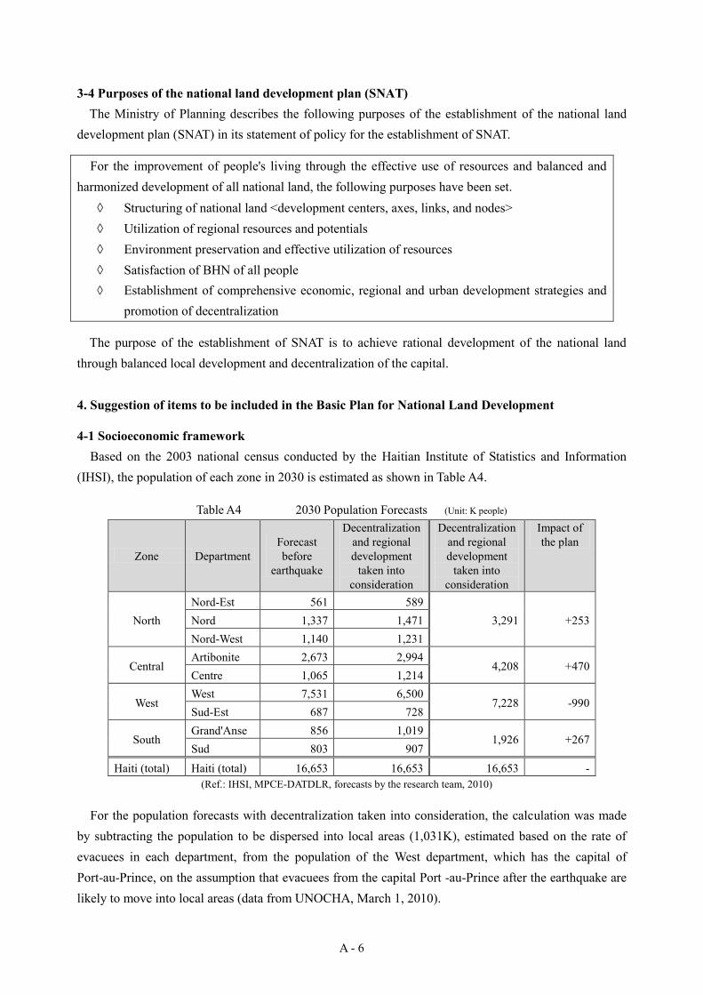
(IHSI), the population of each zone in 2030 is estimated as shown in Table A4.
Table A4 2030 Population Forecasts (Unit: K people)
Zone Department Forecast before
earthquake
Decentralization and regional development
taken into consideration
Decentralization and regional development
taken into consideration
Impact of the plan
North Nord-Est 561 589
3,291 +253 Nord 1,337 1,471 Nord-West 1,140 1,231
Central Artibonite 2,673 2,994
4,208 +470 Centre 1,065 1,214
West West 7,531 6,500
7,228 -990 Sud-Est 687 728
South Grand'Anse 856 1,019
1,926 +267 Sud 803 907
Haiti (total) Haiti (total) 16,653 16,653 16,653 - (Ref.: IHSI, MPCE-DATDLR, forecasts by the research team, 2010)
For the population forecasts with decentralization taken into consideration, the calculation was made by subtracting the population to be dispersed into local areas (1,031K), estimated based on the rate of evacuees in each department, from the population of the West department, which has the capital of Port-au-Prince, on the assumption that evacuees from the capital Port -au-Prince after the earthquake are likely to move into local areas (data from UNOCHA, March 1, 2010).
A - 7
4-2 Policy for the establishment of the Basic Plan for National Land Development Like Haiti, Japan has geographic environment vulnerable to large-scale natural disasters, but the
country achieved further development every time it experienced a disaster, aiming at systematic national development for balanced development of national land and at development of urban districts well-prepared against disasters.
For example, to address the issue of densely populated areas with deteriorated houses in urban districts, development and improvement of road networks, adoption of flame-resistant materials for buildings, standardization of seismic building standards, revision and improvement of these standards at a time of each earthquake, improvement of public disaster reduction centers etc. have been carried out based on city plans. Moreover, balanced social and economic development has been achieved through the establishment of National Comprehensive Development Plans and the development of regional development bases and improvement of a transportation network connecting such bases. Similarly in Haiti, efforts for self-sustaining development can be made through the development and implementation of similar legal systems and development policies and through continued actions for social and economic development with no backward movements to prepare against possible future natural disasters. It is also important to create a system to increase preparedness against hurricanes, earthquakes and other types of disasters that will occur in the future, so that damage will be minimized and quick recovery will be made possible. Considering all of this, the policy for the establishment of the Basic Plan for National Land Development shall be as below.
(1) Decentralization (mitigation of overconcentration) = balanced development of national land
(2) Development of cities well-prepared against disasters = promotion of disaster reduction administration
In order to carry out the above-described policies, For (1), it is effective to develop nodes for the connection with overseas such as airports and sea ports
and connect such nodes and bases through the development of social infrastructures for regional base functions.
For (2), it is important to reduce flood damage and promote water use for life and agriculture through the establishment and implementation of a comprehensive flood control and watershed management plan. For this purpose, disaster reduction administration should be promoted.
Considering the above, the core measures to promote the above-described policies shall be as follows.
◆ Development of regional bases and improvement of transportation network ◆ Disaster reduction - comprehensive flood control and watershed management

A - 8
4-3 Concept and vision of the Basic Plan for National Land Development Based on the vision and concept of the Basic Plan for National Land Development, we propose a
concept for the development of regional bases and a transportation network tailored to the development potential to each zone as shown in Table A5.
Table A5 Concept for Development by Zone Zone Potential of development Regional development
base Sub-development
center Transportation
network I. North zone Industrial development centering
on tourism development, free zone and trade
Kap Ayisyen Fort-Libert, Port-de-Paix
Route 1 Route 2
II. Central zone Agriculture and processing of agricultural products
Gonaives Hinche
III. West zone (Capital region)
Service industry, economic and industrial center
Port-au-Prince (satellite cities: Léogâne, Cabaret and Croix-des-Bouquets)
Miragoane Jacmel Route 2, Route 4,
arterial roads to Dominican Republic
IV. South zone Agriculture, fisheries, processing of agricultural and fishery products
Les Cayes Jeremie
Fig. A3 shows the image of the concepts of Table A5 combined with the development concept proposed by the Haitian government to connect local bases with a network. Establishment of the Basic Plan for National Land Development under this concept is expected to increase the effectiveness of the development of regional bases and a transportation network based on the policy, “Decentralization (mitigation of overconcentration) is equal to balanced development
Port de Paix
Cap Haitien
Fort Liberte
Gonaives
Port au Prince
Jacmel
Miragoane
Les Cayes
Jeremie
Hinche
North Zone
[Tourism. Industry]
Central Zone
[Agriculture, Processing Industry]
West (Metropolice) Zone
[Service, Commercial, Industry]
South Zone
[Fishery, Processing Industry]
凡例
開発拠点
サブ開発拠点
郡成長センター
主要国道ネットワーク
サブ ネットワーク
I
Ⅱ
Ⅲ
Ⅳ
Regional development base Sub-developent base
Regional development center Arrondissement growth center
Major national road network
Sub-network
Legend
Fig. A3 Concept and Vision of the Basic Plan for National Land Development (Created by the research team based on a figure proposed by MPCE-DATDLR, 2010)
A - 9
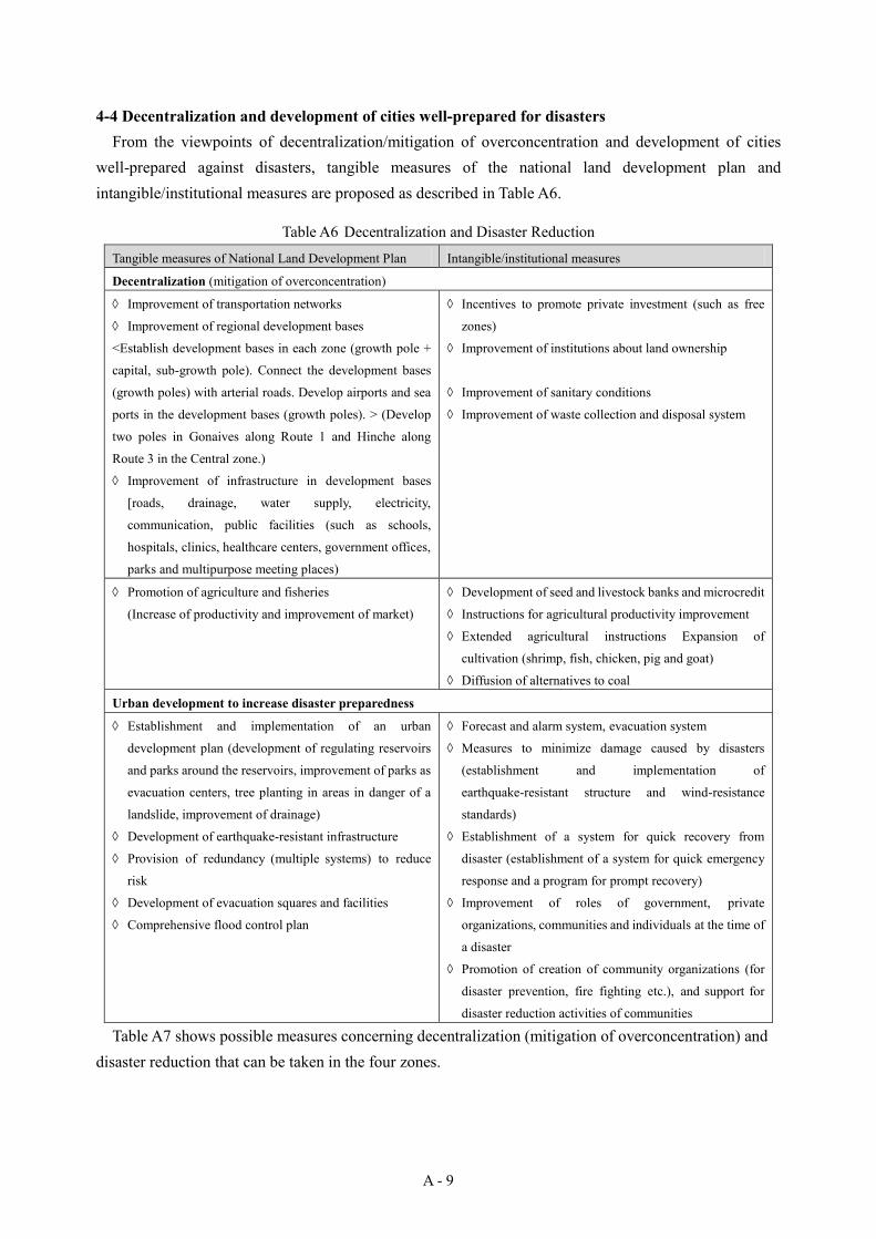
4-4 Decentralization and development of cities well-prepared for disasters From the viewpoints of decentralization/mitigation of overconcentration and development of cities
well-prepared against disasters, tangible measures of the national land development plan and intangible/institutional measures are proposed as described in Table A6.
Table A6 Decentralization and Disaster Reduction
Tangible measures of National Land Development Plan Intangible/institutional measures
Decentralization (mitigation of overconcentration)
Improvement of transportation networks
Improvement of regional development bases
<Establish development bases in each zone (growth pole +
capital, sub-growth pole). Connect the development bases
(growth poles) with arterial roads. Develop airports and sea
ports in the development bases (growth poles). > (Develop
two poles in Gonaives along Route 1 and Hinche along
Route 3 in the Central zone.)
Improvement of infrastructure in development bases
[roads, drainage, water supply, electricity,
communication, public facilities (such as schools,
hospitals, clinics, healthcare centers, government offices,
parks and multipurpose meeting places)
Incentives to promote private investment (such as free
zones)
Improvement of institutions about land ownership
Improvement of sanitary conditions
Improvement of waste collection and disposal system
Promotion of agriculture and fisheries
(Increase of productivity and improvement of market)
Development of seed and livestock banks and microcredit
Instructions for agricultural productivity improvement
Extended agricultural instructions Expansion of
cultivation (shrimp, fish, chicken, pig and goat)
Diffusion of alternatives to coal
Urban development to increase disaster preparedness
Establishment and implementation of an urban
development plan (development of regulating reservoirs
and parks around the reservoirs, improvement of parks as
evacuation centers, tree planting in areas in danger of a
landslide, improvement of drainage)
Development of earthquake-resistant infrastructure
Provision of redundancy (multiple systems) to reduce
risk
Development of evacuation squares and facilities
Comprehensive flood control plan
Forecast and alarm system, evacuation system
Measures to minimize damage caused by disasters
(establishment and implementation of
earthquake-resistant structure and wind-resistance
standards)
Establishment of a system for quick recovery from
disaster (establishment of a system for quick emergency
response and a program for prompt recovery)
Improvement of roles of government, private
organizations, communities and individuals at the time of
a disaster
Promotion of creation of community organizations (for
disaster prevention, fire fighting etc.), and support for
disaster reduction activities of communities
Table A7 shows possible measures concerning decentralization (mitigation of overconcentration) and disaster reduction that can be taken in the four zones.
A - 10
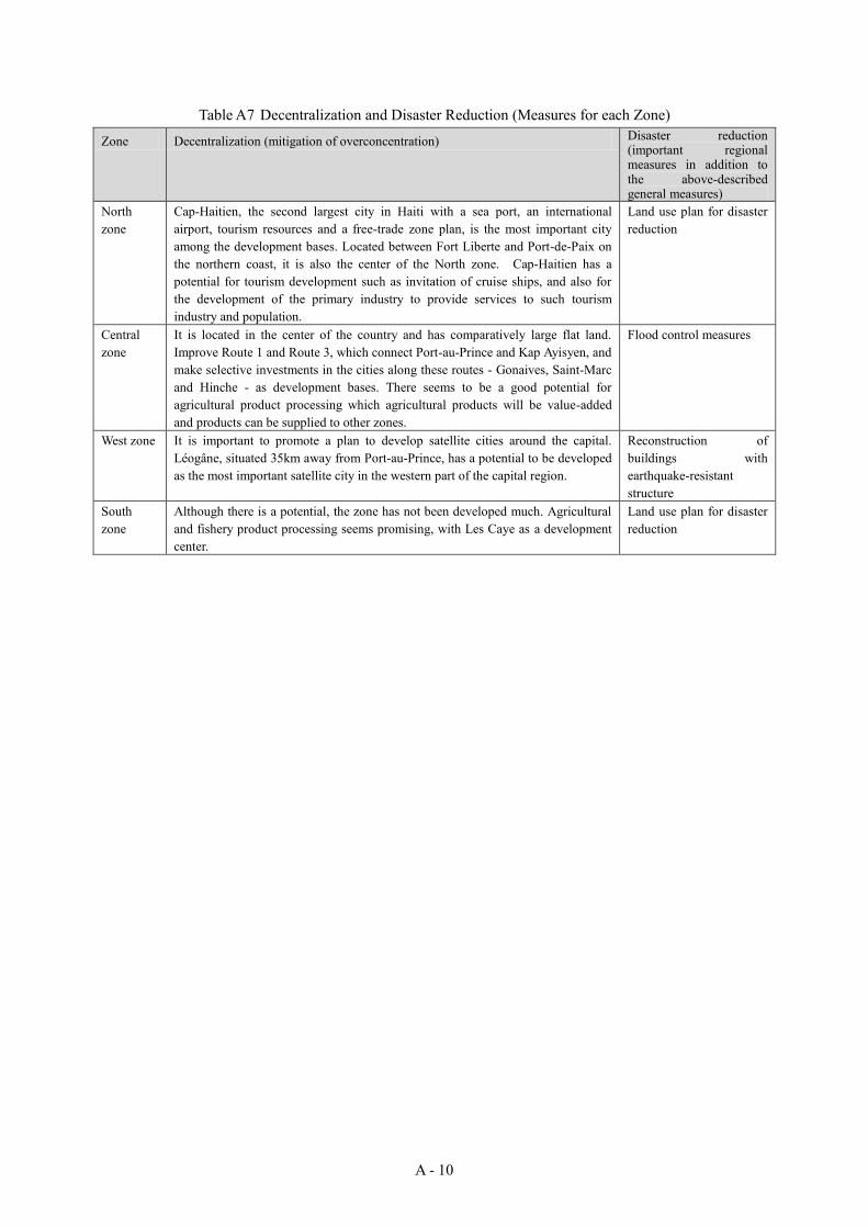
Table A7 Decentralization and Disaster Reduction (Measures for each Zone)
Zone Decentralization (mitigation of overconcentration) Disaster reduction (important regional measures in addition to the above-described general measures)
North zone
Cap-Haitien, the second largest city in Haiti with a sea port, an international airport, tourism resources and a free-trade zone plan, is the most important city among the development bases. Located between Fort Liberte and Port-de-Paix on the northern coast, it is also the center of the North zone. Cap-Haitien has a potential for tourism development such as invitation of cruise ships, and also for the development of the primary industry to provide services to such tourism industry and population.
Land use plan for disaster reduction
Central zone
It is located in the center of the country and has comparatively large flat land. Improve Route 1 and Route 3, which connect Port-au-Prince and Kap Ayisyen, and make selective investments in the cities along these routes - Gonaives, Saint-Marc and Hinche - as development bases. There seems to be a good potential for agricultural product processing which agricultural products will be value-added and products can be supplied to other zones.
Flood control measures
West zone It is important to promote a plan to develop satellite cities around the capital. Léogâne, situated 35km away from Port-au-Prince, has a potential to be developed as the most important satellite city in the western part of the capital region.
Reconstruction of buildings with earthquake-resistant structure
South zone
Although there is a potential, the zone has not been developed much. Agricultural and fishery product processing seems promising, with Les Caye as a development center.
Land use plan for disaster reduction
A - 11
4-5 Disaster reduction measures In order to deal with repeated natural threats, it is necessary to establish a system to minimize human
and material damage and allow quick recovery through mutual cooperation and efforts of government organizations, private organizations, community organizations and individuals. The important points of each stage of disaster reduction and recovery/reconstruction are as follows. [Prediction and forecast/alarm] Although it is difficult to predict the risk of future earthquakes, it is possible to predict the areas where earthquakes will occur by analyzing active faults where earthquakes have occurred before. In the areas with a high risk of earthquakes, it is necessary to establish seismic standards for structures and ensure compliance with them. As for hurricane damage, prediction of course, storm area etc. is conducted in some countries including neighboring countries of USA. It is important to share such information and thoroughly enforce such measures as giving out evacuation directives early through prompt communication of forecasts and alarms. Similar measures should be taken against flood and landslide disasters, whose risk increases when a hurricane occurs. Moreover, hazard maps showing the risk of disaster occurrence in the region should be created so that the residents in dangerous areas can be evacuated according to the forecast and warning. Use of land in the areas with high disaster risk should be minimized and appropriate land use should be guided and regulated through the establishment of a land use plan. For example, areas in danger of floods should be kept as public land such as parks and green areas. [Evacuation] Public facilities such as government offices, schools and healthcare centers that will be used as evacuation centers for residents should be built in areas with a minimum risk of disasters. It is also important for such facilities to have quake-resistant structures. More concretely, it is important to use quake-resistant structures (that will allow the facilities to be used as shelters not only at the time of an earthquake but also a hurricane) and improve such facilities so that they can be used as disaster reduction and evacuation centers where emergency supplies are stored. It is also important to improve parks and open spaces so that they can be used as evacuation spaces. Moreover, it is important to widely inform people about these improved evacuation spaces. [Rescue, relief and emergency assistance activities] It is necessary to have roads of enough width and open spaces for rescue, relief and emergency assistance activities. It is hoped that an urban development planning system will be established and carried out to reserve such disaster reduction spaces and control residence and building construction in dangerous areas where floods and other disasters are predicted. It is also important to develop disaster reduction centers as they will play an important role as a center to receive emergency assistance at the time of a disaster. Disaster reduction system
As intangible measures to prevent disasters, not only does the government have to establish a disaster reduction plan, a hazard map, a land use plan including land use restrictions in dangerous areas and a
A - 12
prediction/alarm system but also promote and support community activities for disaster reduction, which are necessary for ensuring the use of such plans and tools among residents.
For this, the existing organization of the Permanent Secretariat of Risk Management (SPGRD) should be strengthened and the existing cooperation in the central government should also be improved so that the basis for a disaster reduction system will be established. At the same time, support of the central government is essential to strengthening the disaster reduction system that covers from the prefecture to communes, section communales and communities and to make the community disaster reduction activities function.
Measures against each type of natural disaster
In the light of the local characteristics of each type of disaster, the following measures are considered necessary.
Earthquake - In Grand'Anse, Nippes, West and Nord departments, which are located near the two active faults
(Septentorial Fault and Enriquillo Fault) where large earthquakes have occurred in the past, caution should be exercised especially against earthquakes.
- It is necessary to define and implement building standards with quake-resistance taken into consideration and develop a building confirmation system based on such standards. It is also necessary to promote construction of quake-resistant buildings and control construction of faulty buildings.
- Quick evacuation in a safe place should be guided in cooperation with disaster reduction activities of communities.
Hurricane - In Sud and Grand'Anse departments, where hurricanes pass especially frequently, wind-resistant
measures for houses should be promoted. - As advance knowledge of weathers etc. can significantly reduces damage, relevant information
should be provided through radio, community wireless system etc. and cooperation should be given to evacuation drills and other community activities to ensure measures and evacuation before the arrival of a hurricane.
Flood - As with measures against hurricanes, information sharing among residents can be effective - Around Gonaïves in the Artibonite department, Cap-Haïtien in the Nord department and Léogâne
in the West department, which have wide low-altitude areas, effective measures will be the promotion of construction of houses with raised flooring as well as construction of drainage to prevent/reduce internal water overflow.
Tidal waves and tsunami - Low-altitude areas are vulnerable to damage when a tropical cyclone passes. Therefore, disaster
reduction measures should be carried out intensively in the low-altitude areas in the Sud
A - 13
department, where hurricanes frequently pass, and around Gonaïves, which has a very large low-altitude area.
- The north coastal area has a high risk of earthquake and therefore of tsunami. To make tangible measures effective, breakwaters need to be constructed continuously and extensively along the coast but it would cost a lot. Instead, it will be effective to thoroughly carry out intangible measures such as evacuation drills and development of a hazard map.
Landslide - The country is vulnerable to damage by landslides as forests cover below 3% of the total area as a
result of deforestation. - Although the most important thing is to increase the forest coverage through promotion of tree
planting, it would require tremendous amounts of money and time. Therefore, priority should be given to soil erosion prevention works (simple check dam etc.), planting of fruit trees, installation of gabions at toe slope and other measures to prevent soil erosion.
4-6 Items to be included in the plan for each sector
In order to promote balanced development of national land and development of a city well-prepared against disasters at the same time, it is important to establish an infrastructure development plan for each sector based on the Basic Plan for National Land Development and carry out development in a planned manner. The infrastructure development policy for each sector is summarized as below. (1) Traffic planning 1) Roads
In order to ease overconcentration in the capital and develop regional development bases, it is important to improve arterial roads connecting such bases so that passenger and cargo transportation can be carried out rapidly and at low cost. Improvement of such roads as a road network connecting urban centers will make it easy to secure routes for evacuation and transportation of relief supplies at the time of a disaster. Improvement of arterial roads (width, paving, slopes and bridges)
<Improvement of Routes 1 to 4 and elimination of bottlenecks> Improvement of secondary roads (width, paving, slopes and bridges) Improvement of urban roads (improvement of paving and intersections, and elimination of
bottlenecks) 2) Ports
Ports are used for large-volume transportation, import and export. It is important to improve ports in development bases. Improvement of ports (Port-au-Prince, Cap Haitien, Gonaives, Les Cayes etc.)
3) Airports In order to attract international businesses and tourists by taking advantage of diasporas’
A - 14
contributions to Haitian economy and culture and also to facilitate their activities, airports in development bases should be improved. Improvement of airports (Port-au-Prince, Cap Haitien, Les Cayes etc.)
(2) Water supply and sanitary facilities The cholera epidemic in October 2010, combined with poor sanitary conditions and medical circumstances, took the lives of many citizens. Development and improvement of water supply and sanitary facilities with proper sanitary control is urgently required especially in densely populated areas vulnerable to damage of infectious diseases, as such facilities are the fundamental facilities most needed for people's life and health as well as for the prevention of infectious diseases including cholera. Development of water supply facilities in major cities (water intake, purification, storage and
distribution) Development of sanitary and drainage facilities in major cities (sewage treatment facilities
including septic tanks etc.) Development of waste disposal sites
(3) Electric power facilities Electric power facilities are important basic infrastructure not only for the development of industries and economy but also for people's life. It is suggested to develop environmentally-friendly small-scale hydraulic power generation facilities that do not need fossil fuel, taking advantage of the mountainous geography. It will require forestation and environmental improvement at the same time. In urban districts, development of solar power generation facilities will be effective. Development of power generation, transformation and distribution facilities Development of small-scale hydraulic power generation facilities Development of solar power generation facilities
(4) Communication facilities Although the development of communication facilities will basically be led by private sectors, it is proposed that cooperation between the government and private sectors should be developed for the emergency public use of widespread mobile phone networks. Forecasts and alarms for such disasters as hurricanes and emergency radio broadcast should be expanded and improved. Improvement of mobile phone networks (private sector development) Improvement of Internet access (private sector development) Improvement of emergency radio networks
(5) Cultural and educational facilities Education is not only basic human needs but also the basis for economic development. It is hoped that development of school facilities, which have been scarce since before the earthquake, will be promoted and that such facilities will be used as an evacuation center and function as a disaster reduction center when a disaster occurs. Reconstruction and development of elementary and secondary schools
A - 15
Development of higher education and research facilities Development of libraries Development of sport facilities
(6) Healthcare facilities Such facilities are indispensable to public health. It is hoped that such facilities will be constructed with quake-resistant structures so that they can be used during disasters, and will be constructed in areas with a low risk of inundation at the time of a flood. Establishment of a referral system and development of related facilities (advanced medical
hospitals, base hospitals and clinics) Development of public health centers
(7) Urban and local facilities Government offices are necessary to provide public services. Such facilities should have quake-resistant structures so that they can be used as an evacuation center in case of earthquake, hurricane, flood etc. and can also function as a disaster reduction center. Parks should be improved as emergency evacuation space. Improvement of public facilities (government offices, markets and parks)
(8) Flood control facilities As measures against flood caused by a hurricane etc., the following improvements should be promoted to reduce the risk of a large scale disaster caused by a flood. River improvement (improvement of river channels and levees) Development of multipurpose dams Development of erosion control facilities Forestation
(9) Agricultural and fishery facilities Agriculture and fisheries are key industries of Haiti and support the stable food supply to the public. It is important to develop facilities to support the growth of these industries. Development and improvement of irrigation facilities Development of farm land and improvement of land plots Development of distribution centers for agricultural products and markets Development of fishing ports and cold storage facilities
(10)Houses Improvement of institutions about land ownership and land ledgers that will be required to
promote various types of development Development of low-cost houses in and around regional bases Development of a housing finance system Coordination with quake-resistance standards (financing only for quake-resistant houses)
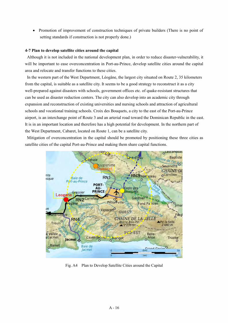
A - 16
Promotion of improvement of construction techniques of private builders (There is no point of setting standards if construction is not properly done.)
4-7 Plan to develop satellite cities around the capital Although it is not included in the national development plan, in order to reduce disaster-vulnerability, it
will be important to ease overconcentration in Port-au-Prince, develop satellite cities around the capital area and relocate and transfer functions to these cities. In the western part of the West Department, Léogâne, the largest city situated on Route 2, 35 kilometers
from the capital, is suitable as a satellite city. It seems to be a good strategy to reconstruct it as a city well-prepared against disasters with schools, government offices etc. of quake-resistant structures that can be used as disaster reduction centers. The city can also develop into an academic city through expansion and reconstruction of existing universities and nursing schools and attraction of agricultural schools and vocational training schools. Croix des Bouquets, a city to the east of the Port-au-Prince airport, is an interchange point of Route 3 and an arterial road toward the Dominican Republic in the east. It is in an important location and therefore has a high potential for development. In the northern part of the West Department, Cabaret, located on Route 1, can be a satellite city. Mitigation of overconcentration in the capital should be promoted by positioning these three cities as
satellite cities of the capital Port-au-Prince and making them share capital functions.
空
港
Cabaret
RN1 RN3
RN4
RN2Leogane
Fig. A4 Plan to Develop Satellite Cities around the Capital
A - 17
5. Recommendations
It is hoped that the “Items to be included in the Basic Plan for National Land Development” proposed in this part will be used for the national land development plan (SNAT) and that recovery from the large disaster will be steadily achieved in Haiti. Based on the results of the studies conducted in the past, we recommend the followings for the recovery of Haiti.
They still need more data for the establishment of the basic plan for national land development. It is necessary to investigate the actual state of infrastructure development across the country, socioeconomic conditions of each region etc. and analyze the results.
The establishment of the Basic Plan for National Land Development should be carried out in coordination with local development plans created by local governments, and it is necessary to collect information and deepen exchanges among relevant organizations and personnel through the support activities for the establishment of local development plans.
It is hoped that the basic plan for national land development will be utilized for the establishment of the national land development plan (SNAT), which Haitian government has been working on since before the disaster. As there was a delay in establishing the national land development plan (SNAT) due to lack of resources (funds and human resources), resources should be increased/improved. For this, it is necessary to create a road map and establish the plan accordingly.
The establishment of the basic plan for national land development will require discussion with all stakeholders, including collection of opinions of residents and local and central governments and coordination among relevant government organizations.
Haitian people, who have survived many natural disasters, have high motivation for recovery, and voluntary reconstruction activities have been actively carried out. To get people’s opinions and reflect them in the plan, taking advantage of such potential, activities of 10 department councils, 42 arrondissement councils, 138 commune councils and 565 section communal councils in the country should be promoted so that regional development plans will be prepared and different opinions will be adjusted through discussion about the basic plan for national land development. It is also important to provide information widely to the public and listen to people’s voices by holding public hearings at the levels of commune, arrondissement, department and country.
If government buildings destroyed by the disaster are relocated and rebuilt in other regions than the capital (e.g. Léogâne or Cabaret), related services can be developed in the surrounding areas and decentralization can be promoted. In such cases, roads to connect the relocation destination and the capital will have to be improved.
A land system and a land register system need to be developed before land development can be started. There have been many cases where a land ownership issue was a bottleneck in construction of temporary housing.
Referring to the experience in Japan, we can also say the followings.
A - 18
Reconstruction after World War II started in 1945, soon after the war. To correct the disproportionate emphasis on the reconstruction of large cities and carry out well-balanced development across the country, the Comprehensive National Land Development Act was established in 1950. Based on this law, several comprehensive national development plans have been developed and carried out, easing overconcentration in the four large cities (Tokyo, Nagoya, Osaka and Kitakyushu) and contributing to balanced national land development. It seems effective also in Haiti to establish and carry out a national land development plan based on such a law.
It is necessary to establish a national development plan presenting an appropriate future vision and clearly showing effective and efficient measures to achieve the vision. An implementation plan for each sector should be established and promoted based on the national development plan.
It is important to repeat the steps of carrying out priority projects based on a national development plan, reviewing the plan every 5-10 years, and establishing a new national development plan and priority project plans.
B - 1
B. Development of the Léogâne Commune Disaster Recovery Plan
1. Current state of Léogâne Commune
Léogâne Commune (commune de Léogâne, in French) 3 is located about 35 kilometers west of the capital Port-au-Prince. It is bordered on the northwest by the bay of Gonaïves, on the east by Gressier and Carrefour Communes, on the south by Jacmel Commune, and on the west by Grand-Goâve Commune. Léogâne Commune has an administrative area of 385 square kilometers and consists of 13 section communales.
About 70% of Léogâne Commune is covered by steep mountains and the remaining 30% is an alluvial plain. In mountainous areas, unregulated cultivation and abandonment have been repeated and the land has become quite denuded with only a small area of natural forests. The plain field is used for agriculture and mainly sugar canes, bananas and mangos are grown. Existing urban districts have been formed mainly in and around the city of Léogâne (ville de Léogâne in French – not an administrative city district but the area within the commune designated as an urban district) and along national roads.
The population of Léogâne Commune is 157,221 as of 2003 (data from IHSI), about 70% of which lives in the three section communales in the plain area.
The Great Haiti Earthquake has created many IDPs (internally displaced persons) in Léogâne Commune. According to the record released by the International Organization for Migration (IDM) in July 2010, there are 281 IDP camps in the commune, with 53,962 families and a population of 234,136.
2. Policy for the development of the disaster recovery plan
Léogâne Commune, especially Léogâne City, was severely damaged by the Great Haiti Earthquake. However, as many poorly-constructed buildings were destroyed, this can be considered as a good opportunity to rebuild it into a better regional base. Based on the policy for the establishment of the basic plan for national land development described earlier, the policy for the establishment of the Léogâne Commune Disaster Recovery Plan shall be as follows. Establish a regional development plan for the recovery of the whole commune of Léogâne
Commune and work toward effective and efficient recovery. Absorb population and industries as an important satellite city to ease overconcentration in the
capital and support the capital’s functions, and aim for sound development of the economy and infrastructures.
Make efforts to increase the disaster-preparedness by establishing a land use plan for the whole city of Léogâne and designating areas for priority reconstruction measures.
As farmland occupies most of Léogâne Commune for geographical reasons, reinforcement of the agricultural sector is essential to the recovery of social and economic activities in the community. Therefore, it seems important to put the following items concerning agriculture at the center of the 3 The local governments in Haiti consist of 10 departments, 42 arrondissements, 138 communes and 565 section communales. Although densely-inhabited areas are classified as a city (ville), they are not administrative organizations but controlled by higher-level communes.

B - 2
economic and social activities defined in the disaster recovery plan.
Conservation of farmland and recovery of deserted farmland Efficiency improvement of agricultural production Restriction of urban sprawl (encroachment) Sustainable agricultural development in mountainous areas
For the area around Léogâne City, the central district of Léogâne Commune, a land use plan that can
be a guideline for the development management in the whole city district should be established according to the following development policy so that sound and balanced expansion of the city with no sprawl will be promoted. Achievement of sound urban environment More efficient and compact urban functions Restriction of urban sprawl Promotion of urban agriculture
Moreover, based on the above-mentioned land use plan, areas where recovery measures should be
preferentially carried out will be designated as “zones for reconstruction” and reconstruction works should be carried out according to the following policy.
Development management through regulation and guidance Reconstruction of better living environment Promotion of construction of houses well-prepared against disasters Reinforcement of the community The outline of the disaster recovery plan including development strategies based on the
above-described policy is as described in Table B1.
Table B1 Outline of Disaster Recovery Plan for Léogâne Commune and Léogâne City Area Léogâne Commune Léogâne City Purpose Contribution to easing of
overconcentration in the capital Support for return of IDPs
(internally displaced persons)
Increase disaster-preparedness of the city
Guideline for development management
Broad zoning Land use plan Designation of areas for
reconstruction
Development policy
Conservation of farmland and recovery of deserted farmland
Efficiency improvement of agricultural production
Restriction of urban sprawl Sustainable agricultural
development in mountainous areas
Achievement of sound urban environment
Efficiency improvement of urban functions
Restriction of urban sprawls Promotion of urban agriculture
Development management through regulation and guidance
Reconstruction of better living environment
Promotion of construction of houses well-prepared against disasters
Reinforcement of the community
B - 3
Area Léogâne Commune Léogâne City Development strategy
Conservation of farmland and natural forests and restriction of urban sprawl through zoning
Soil conservation and control of rainwater runoff through reforestation
Watershed management for sustainable agricultural development
Development of agricultural roads in plain areas
Sustainable agricultural development in mountainous areas
Promotion and efficiency improvement of agro-industry
Rationalization of infrastructure investment through enclosure of existing urban areas
Planning of appropriate density Flood control of the
Rouyonne River Active conservation of farmland in
and around urban areas Coexistence of urban land use and
agriculture Proper placement of disaster
reduction bases (such as parks, open spaces and public facilities)
Attraction of population through improvement of educational and healthcare facilities
Development of environment to improve sanitation
Development of public facilities in urbanization promotion areas
Restriction of housing development in other areas than residential and commercial/service areas
Improvement of living environment by communities
Redevelopment of dense urban areas
Land readjustment in areas where urbanization is in progress
Community reinforcement and reconstruction of houses through the use of NGOs
Effective utilization of the bank s of the Rouyonne River
(Data from JICA research team)
3. Framework for the plan (Ttarget year 2020)
Based on the future population forecast of each department by IHSI and MPCE, we have estimated future population of Léogâne Commune. As shown in Table B2, it is estimated that the population will be around 278,000 in 2020, the target year of the disaster recovery plan.
Table B2 Estimated Population of Léogâne Commune
2003 (Census) 2010 2020
Population 157,221 198,346 278,478 (Data from JICA research team)
As development control based on a land use plan will be carried out in Léogâne City, the future population will be controlled according to the target population density for each land use. Based on the land use plan to be described later, the estimated population of Léogâne City in 2020 is 41,0004.
4. Zoning of Léogâne Commune
Based on the above-described policy for sound agriculture and absorption of population and industries, effective and efficient land use should be encouraged through zoning of Léogâne Commune into two main land use categories, nonurban land use and urban land use. The nonurban land use area will consist of agricultural zone and nature zone, while the urban land use area will consist of city center zone, agro-industry zone and residential zone. Plain areas and mountainous areas have been zoned based on the natural terrain.
As seen in Fig. B1, sound development of the city and conservation and development of good
4 For the calculation of the population of the whole West Department, which has the capital Port-au-Prince, we used a population increase rate
lower than the simple trend as the population concentration in Port-au-Prince will be controlled in a planned manner. (See A4-1.) However, for Léogâne Commune, we used the high increate rate set by IHSI as it will absorb some population of Port-au-Prince.

B - 4
farmland will be aimed for with clear distinction between urban land use areas (city center, residential and agro-industry zones) and agricultural zone. Based on the policy to protect the natural environment and promote agriculture, urban land use in agricultural and nature zones should be restricted while effective and dense land utilization should be promoted in the urban land use area. The plain area is about 117 square kilometers (about 30% of the whole area of the commune), and the population density in 2020 will be about 1,650 per square kilometer.
Mountainous areas should be preserved as a natural environment zone, where efforts will be made for reforestation and sustainable agriculture in harmony with the nature, except in Fond de Boudin and Trouin in the southwest, where residential areas will be developed.
(Data from JICA research team)
Fig.B1 Zoning of Léogâne Commune
City center zone
Agro-industry zone
Residential zone
Agricultural zone
Natural environment zone
Léogâne City Administrative borders of section communales Major roads
Legend
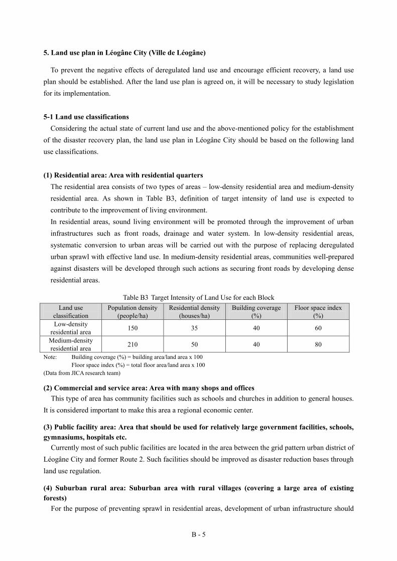
B - 5
5. Land use plan in Léogâne City (Ville de Léogâne)
To prevent the negative effects of deregulated land use and encourage efficient recovery, a land use plan should be established. After the land use plan is agreed on, it will be necessary to study legislation for its implementation.
5-1 Land use classifications Considering the actual state of current land use and the above-mentioned policy for the establishment
of the disaster recovery plan, the land use plan in Léogâne City should be based on the following land use classifications.
(1) Residential area: Area with residential quarters The residential area consists of two types of areas – low-density residential area and medium-density residential area. As shown in Table B3, definition of target intensity of land use is expected to contribute to the improvement of living environment. In residential areas, sound living environment will be promoted through the improvement of urban infrastructures such as front roads, drainage and water system. In low-density residential areas, systematic conversion to urban areas will be carried out with the purpose of replacing deregulated urban sprawl with effective land use. In medium-density residential areas, communities well-prepared against disasters will be developed through such actions as securing front roads by developing dense residential areas.
Table B3 Target Intensity of Land Use for each Block Land use
classification Population density
(people/ha) Residential density
(houses/ha) Building coverage
(%) Floor space index
(%) Low-density
residential area 150 35 40 60
Medium-density residential area 210 50 40 80
Note: Building coverage (%) = building area/land area x 100 Floor space index (%) = total floor area/land area x 100 (Data from JICA research team)
(2) Commercial and service area: Area with many shops and offices This type of area has community facilities such as schools and churches in addition to general houses.
It is considered important to make this area a regional economic center.
(3) Public facility area: Area that should be used for relatively large government facilities, schools, gymnasiums, hospitals etc.
Currently most of such public facilities are located in the area between the grid pattern urban district of Léogâne City and former Route 2. Such facilities should be improved as disaster reduction bases through land use regulation.
(4) Suburban rural area: Suburban area with rural villages (covering a large area of existing forests)
For the purpose of preventing sprawl in residential areas, development of urban infrastructure should

B - 6
not be conducted and housing development should be restricted in this type of areas.
Area along the Rouyonne River (buffer green zone): Area to be developed as a buffer green zone to reduce damage caused by flooding of Rouyonne River
It is considered desirable to carry out development of a buffer green zone where residence will be restricted and bank protection of the Rouyonne River with the aim of reducing damage caused by the overflowing Rouyonne River. The width of the green zone will be 200 meters, as defined by the Ministry of the Environment. However, the width can be 100 meters in areas part where 200 meters of width cannot be secured due to some residential areas that have already been formed. Residence in the buffer green zone will basically be prohibited.
(5) Urban farmland preservation area: Area that should be preserved as urban farmland There is a large area of farmland around the existing urban areas of Léogâne City, which add a sense
of liberation and interest to the landscape of the city as well as being important sites for local economic activities of urban agriculture. Although areas where urban sprawl has already progressed should be efficiently urbanized, remaining small area of farmland around urban areas should be kept as future assets through proactive preservation and housing control as such land can contribute to disaster reduction as a buffer zone.
(6) Park and square area: Area with parks and squares As a general rule, there should be a park or square in each neighborhood unit to provide space that has
a function as an evacuation center at the time of a disaster as well as a place for community recreation and other activities.
(7) Grave area: Existing graveyard. The areas should be kept as they are. 5-2 Land use plan
The land use plan of Léogâne City is as shown in Fig.B2. The trend of urbanization, environmental elements to be preserved and disaster reduction necessities have been taken into consideration.
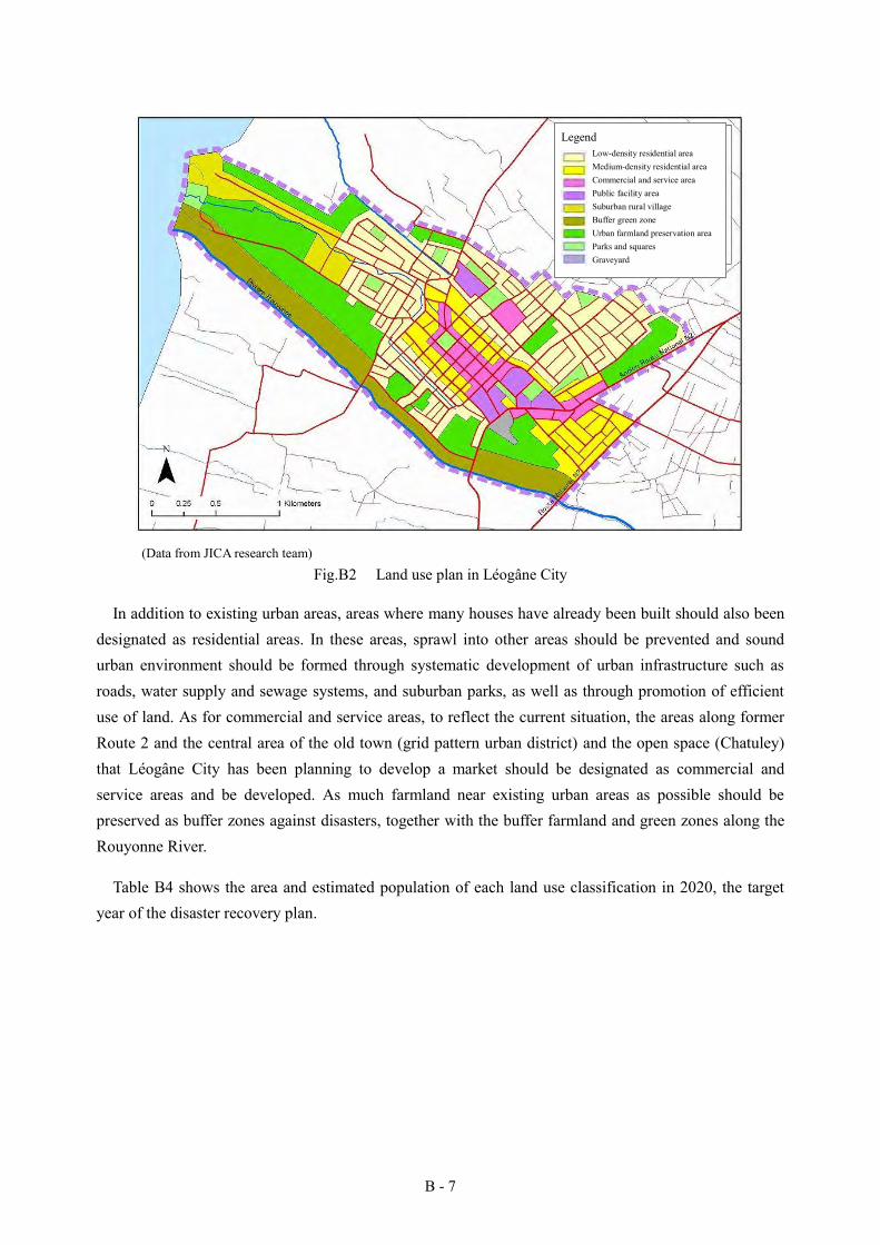
B - 7
(Data from JICA research team)
Fig.B2 Land use plan in Léogâne City
In addition to existing urban areas, areas where many houses have already been built should also been designated as residential areas. In these areas, sprawl into other areas should be prevented and sound urban environment should be formed through systematic development of urban infrastructure such as roads, water supply and sewage systems, and suburban parks, as well as through promotion of efficient use of land. As for commercial and service areas, to reflect the current situation, the areas along former Route 2 and the central area of the old town (grid pattern urban district) and the open space (Chatuley) that Léogâne City has been planning to develop a market should be designated as commercial and service areas and be developed. As much farmland near existing urban areas as possible should be preserved as buffer zones against disasters, together with the buffer farmland and green zones along the Rouyonne River.
Table B4 shows the area and estimated population of each land use classification in 2020, the target year of the disaster recovery plan.
Low-density residential area Medium-density residential area Commercial and service area Public facility area Suburban rural village Buffer green zone Urban farmland preservation area Parks and squares Graveyard
Legend
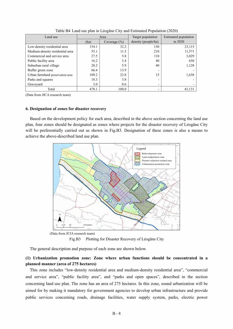
B - 8
Table B4 Land use plan in Léogâne City and Estimated Population (2020) Land use Area Target population
density (people/ha) Estimated population
in 2020 (ha) Coverage (%) Low-density residential area 154.1 32.2 150 23,115 Medium-density residential area 55.1 11.5 210 11,571 Commercial and service area 27.5 5.8 110 3,029 Public facility area 16.2 3.4 40 650 Suburban rural village 28.2 5.9 40 1,128 Buffer green zone 66.4 13.9 - - Urban farmland preservation area 109.2 22.8 15 1,638 Parks and squares 18.3 3.8 - - Graveyard 3.0 0.6 - -
Total 478.1 100.0 - 41,131 (Data from JICA research team)
6. Designation of zones for disaster recovery
Based on the development policy for each area, described in the above section concerning the land use plan, four zones should be designated as zones where projects for the disaster recovery of Léogâne City will be preferentially carried out as shown in Fig.B3. Designation of these zones is also a means to achieve the above-described land use plan.
(Data from JCIA research team)
Fig.B3 Plotting for Disaster Recovery of Léogâne City
The general description and purpose of each zone are shown below.
(1) Urbanization promotion zone: Zone where urban functions should be concentrated in a planned manner (area of 275 hectares)
This zone includes “low-density residential area and medium-density residential area”, “commercial and service area”, “public facility area”, and “parks and open spaces”, described in the section concerning land use plan. The zone has an area of 275 hectares. In this zone, sound urbanization will be aimed for by making it mandatory for government agencies to develop urban infrastructure and provide public services concerning roads, drainage facilities, water supply system, parks, electric power
Redevelopment zone Land readjustment zone Disaster reduction orchard zone Urbanization promotion zone
Legend
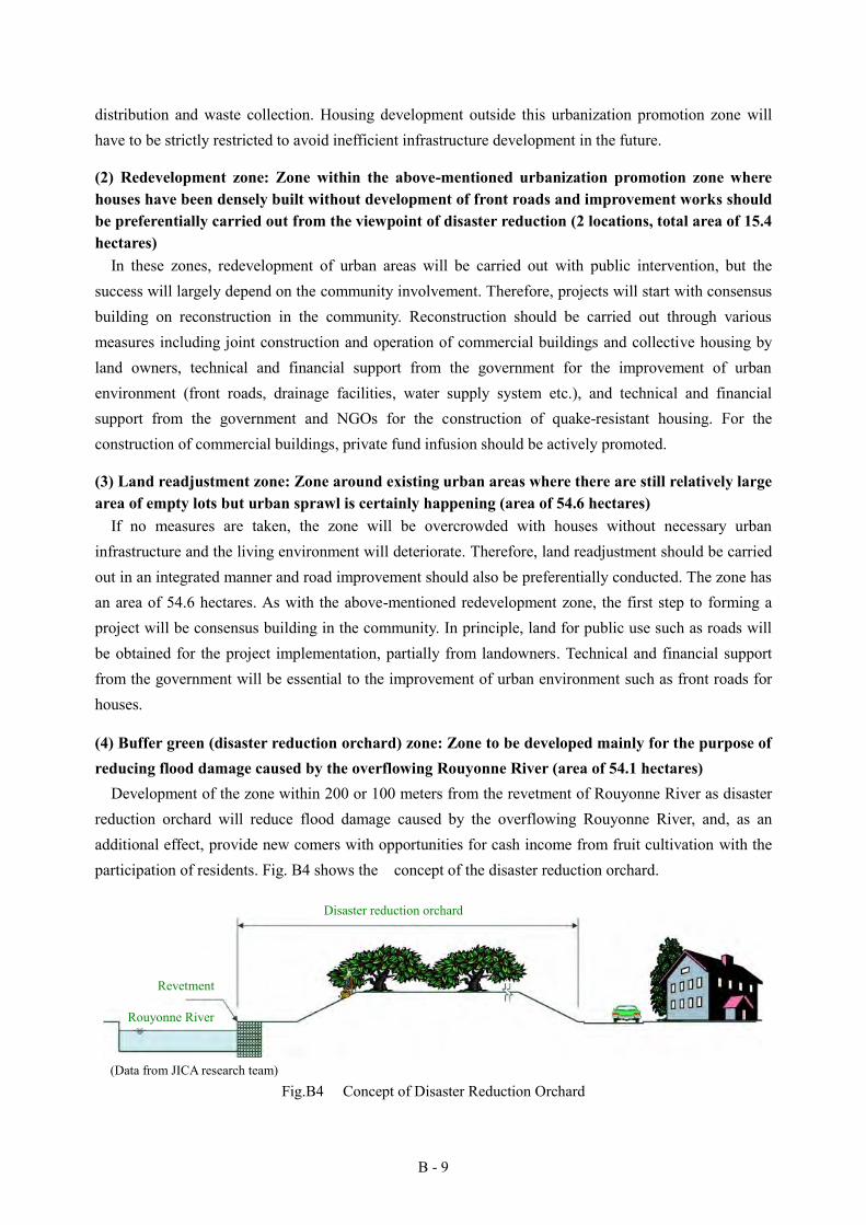
B - 9
distribution and waste collection. Housing development outside this urbanization promotion zone will have to be strictly restricted to avoid inefficient infrastructure development in the future.
(2) Redevelopment zone: Zone within the above-mentioned urbanization promotion zone where houses have been densely built without development of front roads and improvement works should be preferentially carried out from the viewpoint of disaster reduction (2 locations, total area of 15.4 hectares)
In these zones, redevelopment of urban areas will be carried out with public intervention, but the success will largely depend on the community involvement. Therefore, projects will start with consensus building on reconstruction in the community. Reconstruction should be carried out through various measures including joint construction and operation of commercial buildings and collective housing by land owners, technical and financial support from the government for the improvement of urban environment (front roads, drainage facilities, water supply system etc.), and technical and financial support from the government and NGOs for the construction of quake-resistant housing. For the construction of commercial buildings, private fund infusion should be actively promoted.
(3) Land readjustment zone: Zone around existing urban areas where there are still relatively large area of empty lots but urban sprawl is certainly happening (area of 54.6 hectares)
If no measures are taken, the zone will be overcrowded with houses without necessary urban infrastructure and the living environment will deteriorate. Therefore, land readjustment should be carried out in an integrated manner and road improvement should also be preferentially conducted. The zone has an area of 54.6 hectares. As with the above-mentioned redevelopment zone, the first step to forming a project will be consensus building in the community. In principle, land for public use such as roads will be obtained for the project implementation, partially from landowners. Technical and financial support from the government will be essential to the improvement of urban environment such as front roads for houses.
(4) Buffer green (disaster reduction orchard) zone: Zone to be developed mainly for the purpose of reducing flood damage caused by the overflowing Rouyonne River (area of 54.1 hectares)
Development of the zone within 200 or 100 meters from the revetment of Rouyonne River as disaster reduction orchard will reduce flood damage caused by the overflowing Rouyonne River, and, as an additional effect, provide new comers with opportunities for cash income from fruit cultivation with the participation of residents. Fig. B4 shows the concept of the disaster reduction orchard.
(Data from JICA research team)
Fig.B4 Concept of Disaster Reduction Orchard
Disaster reduction orchard
Revetment
Rouyonne River
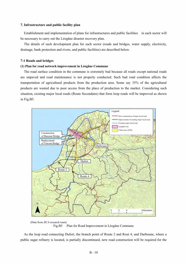
B - 10
7. Infrastructure and public facility plan
Establishment and implementation of plans for infrastructures and public facilities in each sector will be necessary to carry out the Léogâne disaster recovery plan.
The details of such development plan for each sector (roads and bridges, water supply, electricity, drainage, bank protection and rivers, and public facilities) are described below.
7-1 Roads and bridges (1) Plan for road network improvement in Léogâne Commune
The road surface condition in the commune is extremely bad because all roads except national roads are unpaved and road maintenance is not properly conducted. Such bad road condition affects the transportation of agricultural products from the production area. Some say 35% of the agricultural products are wasted due to poor access from the place of production to the market. Considering such situation, existing major local roads (Route Secondaire) that form loop roads will be improved as shown in Fig.B5.
(Data from JICA research team)
Fig.B5 Plan for Road Improvement in Léogâne Commune
As the loop road connecting Dufort, the branch point of Route 2 and Rout 4, and Darboune, where a public sugar refinery is located, is partially discontinued, new road construction will be required for the
New construction of major local road
Improvement of existing major local road
Existing major local road
Léogâne City
Urban area (2020)
Legend
Route 2
Construction of Baussan Bridge
Replacement of Vincent Bridge
Dufort
Darboune
Route 4
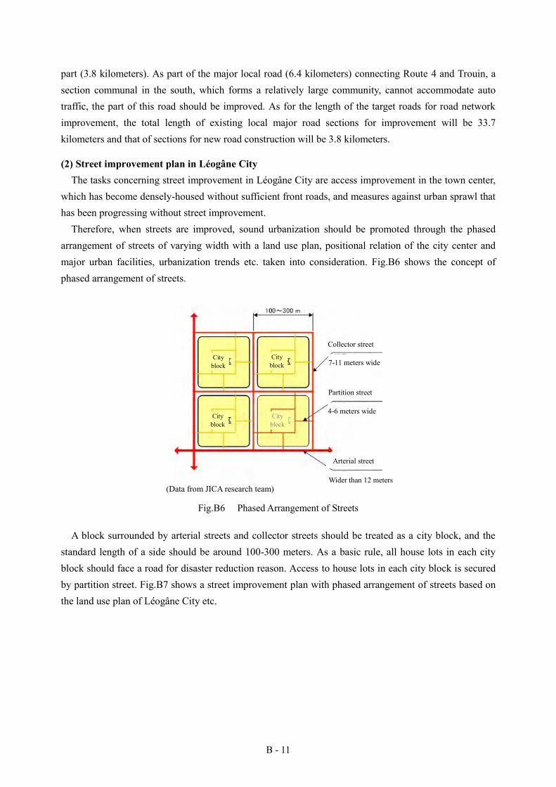
B - 11
part (3.8 kilometers). As part of the major local road (6.4 kilometers) connecting Route 4 and Trouin, a section communal in the south, which forms a relatively large community, cannot accommodate auto traffic, the part of this road should be improved. As for the length of the target roads for road network improvement, the total length of existing local major road sections for improvement will be 33.7 kilometers and that of sections for new road construction will be 3.8 kilometers.
(2) Street improvement plan in Léogâne City The tasks concerning street improvement in Léogâne City are access improvement in the town center,
which has become densely-housed without sufficient front roads, and measures against urban sprawl that has been progressing without street improvement.
Therefore, when streets are improved, sound urbanization should be promoted through the phased arrangement of streets of varying width with a land use plan, positional relation of the city center and major urban facilities, urbanization trends etc. taken into consideration. Fig.B6 shows the concept of phased arrangement of streets.
(Data from JICA research team)
Fig.B6 Phased Arrangement of Streets
A block surrounded by arterial streets and collector streets should be treated as a city block, and the standard length of a side should be around 100-300 meters. As a basic rule, all house lots in each city block should face a road for disaster reduction reason. Access to house lots in each city block is secured by partition street. Fig.B7 shows a street improvement plan with phased arrangement of streets based on the land use plan of Léogâne City etc.
Collector street
7-11 meters wide
Partition street
4-6 meters wide
Arterial street
Wider than 12 meters
City block
City block
City block
City block

B - 12
(Data from JICA research team)
Fig.B7 Street Improvement Plan in Léogâne City
(3) Road paving in urban areas As the existing grid pattern roads in the city center are still largely unpaved, pavement improvement
works will be started in 2011 with a Japanese grant aid for the purpose of improving the environment for economic activities.
(4) Replacement of existing bridges and construction of new ones As the Vincent Bridge over the Rouyonne River, which runs in the southwest of Léogâne City, has
become a bottleneck where the river course cross-section becomes too small when the river is swollen due to insufficient cross-section caused by accretion of sand discharged from the upper river basin, river bank erosion and some structural issues (short span and small clearance), there is an urgent need to replace this bridge. As Baussan, downstream from the Vincent Bridge, is an important traffic route for neighboring community, construction of a new bridge needs be planned where the road crosses the river.
7-2 Water supply
The task of Léogâne City concerning water supply is the restoration and expansion of water supply service, which has stopped since 2008, when a hurricane washed out the water line laid from a spring near the Momance River. Stable and safe water supply is essential to the improvement of people’s living and economic activities. Therefore, restoration and reconstruction of water facilities will be important. 7-3 Electricity
Issues concerning electricity supply in Léogâne Commune are lack of stable power supply capacity, inadequate capacity of distribution lines to cope with future demand increase, and lack of emergency power supply in public facilities. To solve these issues, we propose the following concept for electricity
Legend Existing road
National road Major local road Minor street
Street network (plan) Arterial street Collector street
B - 13
supply development.
Ensuring of stable life of residents through early restoration of the existing electricity network Ensuring of stable electric power supply by forecasting electricity demand and reviewing
electricity network improvement plan in consideration of relocation of residents Coordination between the emergency electricity network of Léogâne Commune and other
networks from independent power sources in neighboring areas Improvement of electricity supply capacity through the construction of new electric power lines
(69kV) Securement of emergency alternative power source through the installation of emergency
generators in public facilities and introduction of renewable energy such as solar power
7-4 Bank protection and rivers To reduce damage by flooding of the Rouyonne River, bank erosion needs to be controlled with bank
protection measures such as installation of wire cylinders in the downstream from Neuf Bridge, in addition to the above-described replacement of Vincent Bridge. Bank protection works will be carried out on the right bank of the Rouyonne River to reduce flood damage in urban areas, but it will also be necessary in the future to carry out bank protection works on the left bank so that flood damage in surrounding farmland will be reduced. 7-5 Drainage
To reduce damage by flooding of the Rouyonne River, drainage development in urban districts will also have to be tackled. Improvement of drainage facilities will contribute to the improvement of sanitary conditions as well.
In 2011, road drainage construction will be conducted with a Japanese grant aid around the city center together with road pavement construction. As the purpose of this work is emergency reconstruction, it will only be to discharge waste water from existing urban areas to existing drainage. In the future, a watershed management plan for the whole watershed will have to be established and implemented. 7-6 Public facilities
Public buildings that had been built poorly, such as cultural and educational facilities including schools and libraries, healthcare facilities including public health centers, clinics and hospitals, public facilities including city office, and recreation facilities including parks, were all severely destroyed by the Great Haiti Earthquake and need to be reconstructed soon. For the maintenance of people’s good health, it is necessary to create spaces for health education in school, for preventive medicine and health management in public health centers, for medical treatment in clinics and hospitals etc.
B - 14
8. Building administration improvement plan
To prevent formation of dense residential areas with poorly-constructed houses and promote sound urban environment, land use management, through the use of the building coverage and floor space index, and strict application of building standards can be effective. In order to carry out such measures, the local government has to enhance the qualifications of individual officers through administrative support from various donors and training on urban planning and building administration systems and at the same time to foster people’s trust in the government. Since construction of houses except public ones is carried out by private individuals or corporations, introduction of low-cost method for quake-resistant housing construction and improvement of access to funds as well as compliance with building standards are sought after. 9. Agricultural sector development plan
Agricultural sector is one of the most important economic sectors in Haiti, where over 50% of the population are farmers (Section 4.2.1, Action Plan for National Recovery and Development of Haiti, 2010). Farmland covers as high as 40-85% of the land in the 13 section communales in Léogâne. High priority should be given to this sector because products can be produced immediately and be used as daily foods.
The tasks in the agricultural sector include reforestation of mountainous areas devastated as a result of repeated cultivation and abandonment, development of sustainable agriculture in mountainous areas, modernization of agricultural techniques and improvement of market access. To tackle such tasks, agricultural development should be promoted in the agricultural sector of Léogâne Commune under the following development policies.
Sustainable development of agriculture in mountainous areas through the restoration of natural
forests with replanting and fruit cultivation (It will increase water retaining characteristics, contribute to disaster reduction and promote effective land use.)
Upgrade and expansion of existing irrigation systems and improvement of agricultural roads to maximize potential of agricultural production (Existing irrigation systems and agricultural roads need upgrading and expansion. Priority should be given to the improvement of existing facilities, rather than new development.)
Construction of reservoirs in mountainous areas to obtain irrigation water and drinking water (Reservoirs will increase productivity and promote use of daily life water.)
Supply of agricultural kits, seeds and implements (It will be direct support for the improvement of agricultural productivity.)
Fostering of agricultural extension workers for the implementation of sustainable agriculture (A system for human resource development and diffusion of techniques will be established to continue and extend the activities of agricultural extension workers, and through their guidance, expansion of sustainable agriculture will be promoted.)
B - 15
Structural reform of agriculture in mountainous areas through the introduction of techniques for cultivation in greenhouse and freshwater fish farming (Add value to agricultural products, increase income and improve people’s living.)
Efficiency improvement of the distribution system for agricultural products (Income increase can be achieved when not only production but also the distribution system is improved. Take advantage of the location close to the capital.)
Concentration of agro-industry as a means to create employment and development of related infrastructure such as transportation/distribution facilities, storage facilities, water supply and sewerage systems, and electricity and communication systems (Economy and income should be expanded through the introduction and promotion of agro-industries, such as agricultural product processing, food processing and production of alcoholic beverage.)
10. Disaster reduction plan
Issues of Léogâne Commune concerning disaster reduction include that there is no efficient disaster reduction service organization in the government due to the shortage of manpower and budget; therefore that disaster reduction services cannot be provided to the residents because information related to disaster reduction cannot be collected, analyzed or communicated and cooperation with the central government offices or private services is difficult; that the residents have few self-defense tools against disasters; and that there is a lack of an urban plan to promote creation of a sound and disaster-prepared city and there is also a lack of an organization for the implementation of such a plan.
Government- and community-level measures to address these issues include the followings. (Central government) Establishment of quake-resistant building standards Promotion of quake-resistant measures and prevention of construction of weak buildings through
the development of a building confirmation system Prevention of formation of dense residential areas with laws concerning urban planning Establishment of a flood control plan for major rivers Support from the Disaster Prevention Bureau of the Ministry of Interior for the creation of hazard
maps etc. (Local government) Establishment of a flood control plan for local rivers Implementation of measures such as bank reinforcement based on the flood control plan Announcement of dangerous areas with a hazard map etc. and awareness-raising concerning
disaster reduction (Community) Promotion of formation of a community at the level of city block where there is no community
formed Promotion of information sharing within a community and community disaster reduction activities
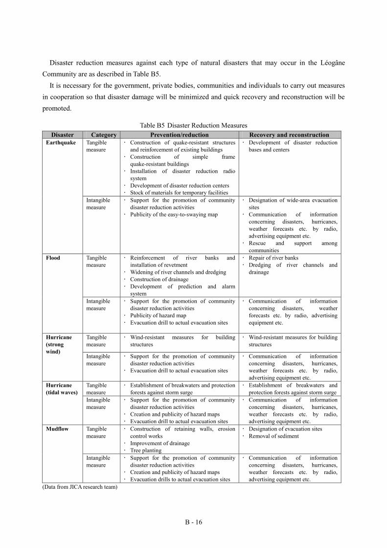
B - 16
Disaster reduction measures against each type of natural disasters that may occur in the Léogâne Community are as described in Table B5.
It is necessary for the government, private bodies, communities and individuals to carry out measures in cooperation so that disaster damage will be minimized and quick recovery and reconstruction will be promoted.
Table B5 Disaster Reduction Measures Disaster Category Prevention/reduction Recovery and reconstruction
Earthquake Tangible measure
Construction of quake-resistant structures and reinforcement of existing buildings
Construction of simple frame quake-resistant buildings
Installation of disaster reduction radio system
Development of disaster reduction centers Stock of materials for temporary facilities
Development of disaster reduction bases and centers
Intangible measure
Support for the promotion of community disaster reduction activities
Publicity of the easy-to-swaying map
Designation of wide-area evacuation sites
Communication of information concerning disasters, hurricanes, weather forecasts etc. by radio, advertising equipment etc.
Rescue and support among communities
Flood Tangible measure
Reinforcement of river banks and installation of revetment
Widening of river channels and dredging Construction of drainage Development of prediction and alarm
system
Repair of river banks Dredging of river channels and
drainage
Intangible measure
Support for the promotion of community disaster reduction activities
Publicity of hazard map Evacuation drill to actual evacuation sites
Communication of information concerning disasters, weather forecasts etc. by radio, advertising equipment etc.
Hurricane (strong wind)
Tangible measure
Wind-resistant measures for building structures
Wind-resistant measures for building structures
Intangible measure
Support for the promotion of community disaster reduction activities
Evacuation drill to actual evacuation sites
Communication of information concerning disasters, hurricanes, weather forecasts etc. by radio, advertising equipment etc.
Hurricane (tidal waves)
Tangible measure
Establishment of breakwaters and protection forests against storm surge
Establishment of breakwaters and protection forests against storm surge
Intangible measure
Support for the promotion of community disaster reduction activities
Creation and publicity of hazard maps Evacuation drill to actual evacuation sites
Communication of information concerning disasters, hurricanes, weather forecasts etc. by radio, advertising equipment etc.
Mudflow Tangible measure
Construction of retaining walls, erosion control works
Improvement of drainage Tree planting
Designation of evacuation sites Removal of sediment
Intangible measure
Support for the promotion of community disaster reduction activities
Creation and publicity of hazard maps Evacuation drills to actual evacuation sites
Communication of information concerning disasters, hurricanes, weather forecasts etc. by radio, advertising equipment etc.
(Data from JICA research team)
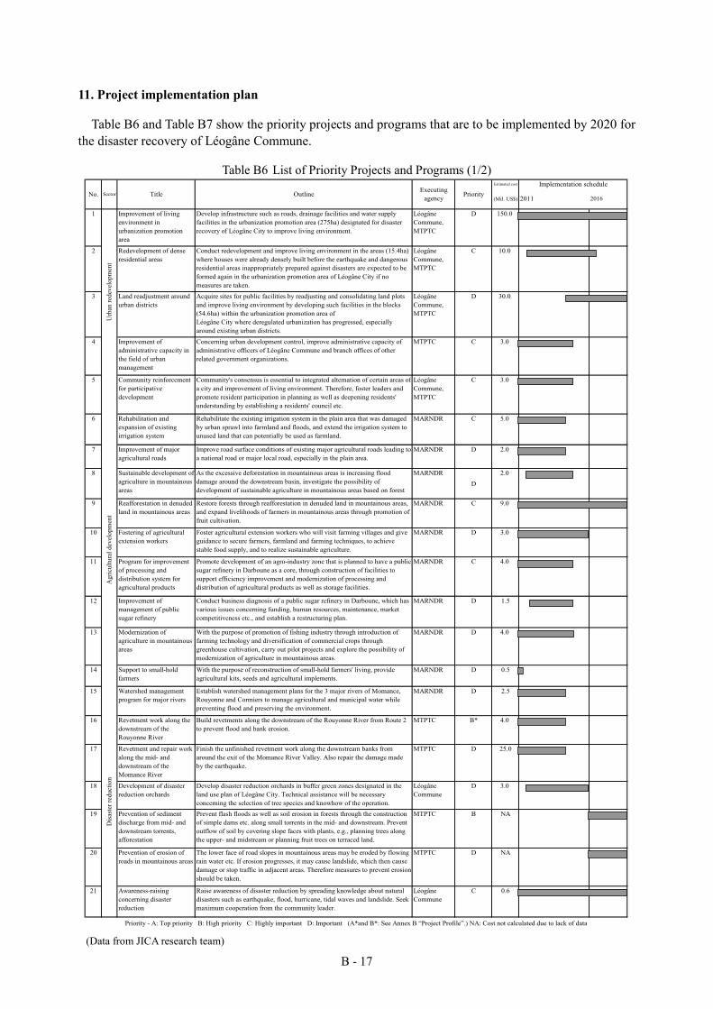
B - 17
11. Project implementation plan
Table B6 and Table B7 show the priority projects and programs that are to be implemented by 2020 for the disaster recovery of Léogâne Commune.
Table B6 List of Priority Projects and Programs (1/2) Estimated cost Implementation schedule
(Mil. US$)
1 Improvement of livingenvironment inurbanization promotionarea
Develop infrastructure such as roads, drainage facilities and water supplyfacilities in the urbanization promotion area (275ha) designated for disasterrecovery of Léogâne City to improve living environment.
LéogâneCommune,MTPTC
D 150.0
2 Redevelopment of denseresidential areas
Conduct redevelopment and improve living environment in the areas (15.4ha)where houses were already densely built before the earthquake and dangerousresidential areas inappropriately prepared against disasters are expected to beformed again in the urbanization promotion area of Léogâne City if nomeasures are taken.
LéogâneCommune,MTPTC
C 10.0
3 Land readjustment aroundurban districts
Acquire sites for public facilities by readjusting and consolidating land plotsand improve living environment by developing such facilities in the blocks(54.6ha) within the urbanization promotion area ofLéogâne City where deregulated urbanization has progressed, especiallyaround existing urban districts.
LéogâneCommune,MTPTC
D 30.0
4 Improvement ofadministrative capacity inthe field of urbanmanagement
Concerning urban development control, improve administrative capacity ofadministrative officers of Léogâne Commune and branch offices of otherrelated government organizations.
MTPTC C 3.0
5 Community reinforcementfor participativedevelopment
Community's consensus is essential to integrated alternation of certain areas ofa city and improvement of living environment. Therefore, foster leaders andpromote resident participation in planning as well as deepening residents'understanding by establishing a residents' council etc.
LéogâneCommune,MTPTC
C 3.0
6 Rehabilitation andexpansion of existingirrigation system
Rehabilitate the existing irrigation system in the plain area that was damagedby urban sprawl into farmland and floods, and extend the irrigation system tounused land that can potentially be used as farmland.
MARNDR C 5.0
7 Improvement of majoragricultural roads
Improve road surface conditions of existing major agricultural roads leading toa national road or major local road, especially in the plain area.
MARNDR D 2.0
8 Sustainable development ofagriculture in mountainousareas
As the excessive deforestation in mountainous areas is increasing flooddamage around the downstream basin, investigate the possibility ofdevelopment of sustainable agriculture in mountainous areas based on forestrestoration.
MARNDRD
2.0
9 Reafforestation in denudedland in mountainous areas
Restore forests through reafforestation in denuded land in mountainous areas,and expand livelihoods of farmers in mountainous areas through promotion offruit cultivation.
MARNDR C 9.0
10 Fostering of agriculturalextension workers
Foster agricultural extension workers who will visit farming villages and giveguidance to secure farmers, farmland and farming techniques, to achievestable food supply, and to realize sustainable agriculture.
MARNDR D 3.0
11 Program for improvementof processing anddistribution system foragricultural products
Promote development of an agro-industry zone that is planned to have a publicsugar refinery in Darboune as a core, through construction of facilities tosupport efficiency improvement and modernization of processing anddistribution of agricultural products as well as storage facilities.
MARNDR C 4.0
12 Improvement ofmanagement of publicsugar refinery
Conduct business diagnosis of a public sugar refinery in Darboune, which hasvarious issues concerning funding, human resources, maintenance, marketcompetitiveness etc., and establish a restructuring plan.
MARNDR D 1.5
13 Modernization ofagriculture in mountainousareas
With the purpose of promotion of fishing industry through introduction offarming technology and diversification of commercial crops throughgreenhouse cultivation, carry out pilot projects and explore the possibility ofmodernization of agriculture in mountainous areas.
MARNDR D 4.0
14 Support to small-holdfarmers
With the purpose of reconstruction of small-hold farmers' living, provideagricultural kits, seeds and agricultural implements.
MARNDR D 0.5
15 Watershed managementprogram for major rivers
Establish watershed management plans for the 3 major rivers of Momance,Rouyonne and Cormiers to manage agricultural and municipal water whilepreventing flood and preserving the environment.
MARNDR D 2.5
16 Revetment work along thedownstream of theRouyonne River
Build revetments along the downstream of the Rouyonne River from Route 2to prevent flood and bank erosion.
MTPTC B* 4.0
17 Revetment and repair workalong the mid- anddownstream of theMomance River
Finish the unfinished revetment work along the downstream banks fromaround the exit of the Momance River Valley. Also repair the damage madeby the earthquake.
MTPTC D 25.0
18 Development of disasterreduction orchards
Develop disaster reduction orchards in buffer green zones designated in theland use plan of Léogâne City. Technical assistance will be necessaryconcerning the selection of tree species and knowhow of the operation.
LéogâneCommune
D 3.0
19 Prevention of sedimentdischarge from mid- anddownstream torrents,afforestation
Prevent flash floods as well as soil erosion in forests through the constructionof simple dams etc. along small torrents in the mid- and downstream. Preventoutflow of soil by covering slope faces with plants, e.g., planning trees alongthe upper- and midstream or planning fruit trees on terraced land.
MTPTC B NA
20 Prevention of erosion ofroads in mountainous areas
The lower face of road slopes in mountainous areas may be eroded by flowingrain water etc. If erosion progresses, it may cause landslide, which then causedamage or stop traffic in adjacent areas. Therefore measures to prevent erosionshould be taken.
MTPTC D NA
21 Awareness-raisingconcerning disasterreduction
Raise awareness of disaster reduction by spreading knowledge about naturaldisasters such as earthquake, flood, hurricane, tidal waves and landslide. Seekmaximum cooperation from the community leader.
LéogâneCommune
C 0.6
Agr
icul
tura
l dev
elop
men
tD
isaste
r red
uctio
n
Priority - A: Top priority B: High priority C: Highly important D: Important (A*and B*: See Annex B “Project Profile”.) NA: Cost not calculated due to lack of data
2011 2016No.
Urb
an re
deve
lopm
ent
Sector Title Outline Executingagency Priority
(Data from JICA research team)
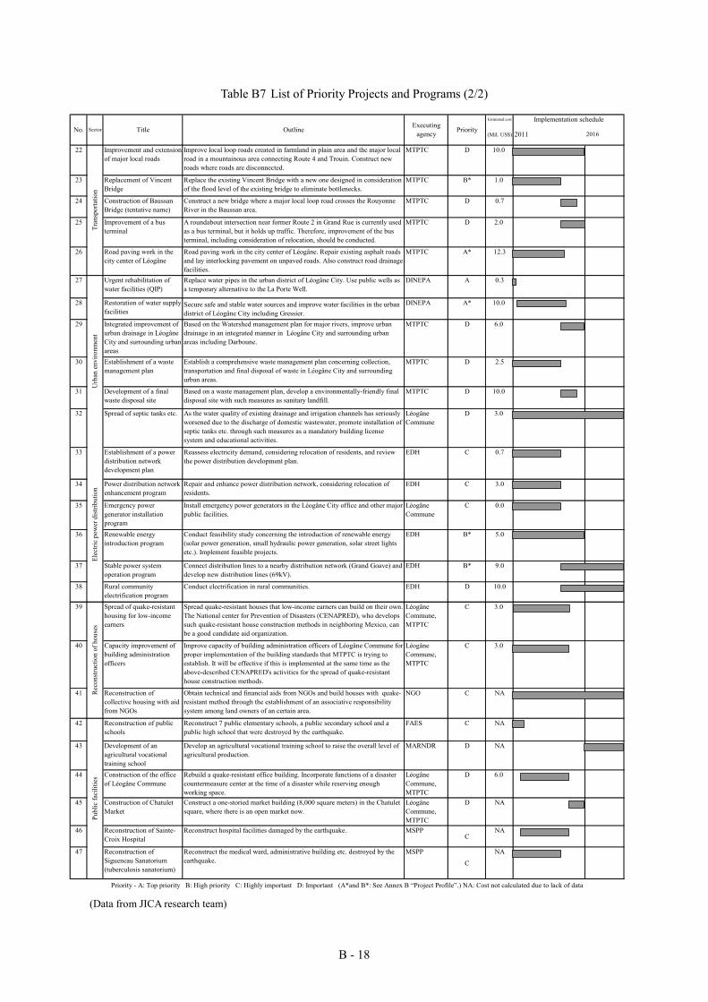
B - 18
Table B7 List of Priority Projects and Programs (2/2)
(Data from JICA research team)
Estimated cost Implementation schedule
(Mil. US$)
22 Improvement and extensionof major local roads
Improve local loop roads created in farmland in plain area and the major localroad in a mountainous area connecting Route 4 and Trouin. Construct newroads where roads are disconnected.
MTPTC D 10.0
23 Replacement of VincentBridge
Replace the existing Vincent Bridge with a new one designed in considerationof the flood level of the existing bridge to eliminate bottlenecks.
MTPTC B* 1.0
24 Construction of BaussanBridge (tentative name)
Construct a new bridge where a major local loop road crosses the RouyonneRiver in the Baussan area.
MTPTC D 0.7
25 Improvement of a busterminal
A roundabout intersection near former Route 2 in Grand Rue is currently usedas a bus terminal, but it holds up traffic. Therefore, improvement of the busterminal, including consideration of relocation, should be conducted.
MTPTC D 2.0
26 Road paving work in thecity center of Léogâne
Road paving work in the city center of Léogâne. Repair existing asphalt roadsand lay interlocking pavement on unpaved roads. Also construct road drainagefacilities.
MTPTC A* 12.3
27 Urgent rehabilitation ofwater facilities (QIP)
Replace water pipes in the urban district of Léogâne City. Use public wells asa temporary alternative to the La Porte Well.
DINEPA A 0.3
28 Restoration of water supplyfacilities
Secure safe and stable water sources and improve water facilities in the urbandistrict of Léogâne City including Gressier.
DINEPA A* 10.0
29 Integrated improvement ofurban drainage in LéogâneCity and surrounding urbanareas
Based on the Watershed management plan for major rivers, improve urbandrainage in an integrated manner in Léogâne City and surrounding urbanareas including Darboune.
MTPTC D 6.0
30 Establishment of a wastemanagement plan
Establish a comprehensive waste management plan concerning collection,transportation and final disposal of waste in Léogâne City and surroundingurban areas.
MTPTC D 2.5
31 Development of a finalwaste disposal site
Based on a waste management plan, develop a environmentally-friendly finaldisposal site with such measures as sanitary landfill.
MTPTC D 10.0
32 Spread of septic tanks etc. As the water quality of existing drainage and irrigation channels has seriouslyworsened due to the discharge of domestic wastewater, promote installation ofseptic tanks etc. through such measures as a mandatory building licensesystem and educational activities.
LéogâneCommune
D 3.0
33 Establishment of a powerdistribution networkdevelopment plan
Reassess electricity demand, considering relocation of residents, and reviewthe power distribution development plan.
EDH C 0.7
34 Power distribution networkenhancement program
Repair and enhance power distribution network, considering relocation ofresidents.
EDH C 3.0
35 Emergency powergenerator installationprogram
Install emergency power generators in the Léogâne City office and other majorpublic facilities.
LéogâneCommune
C 0.0
36 Renewable energyintroduction program
Conduct feasibility study concerning the introduction of renewable energy(solar power generation, small hydraulic power generation, solar street lightsetc.). Implement feasible projects.
EDH B* 5.0
37 Stable power systemoperation program
Connect distribution lines to a nearby distribution network (Grand Goave) anddevelop new distribution lines (69kV).
EDH B* 9.0
38 Rural communityelectrification program
Conduct electrification in rural communities. EDH D 10.0
39 Spread of quake-resistanthousing for low-incomeearners
Spread quake-resistant houses that low-income earners can build on their own.The National center for Prevention of Disasters (CENAPRED), who developssuch quake-resistant house construction methods in neighboring Mexico, canbe a good candidate aid organization.
LéogâneCommune,MTPTC
C 3.0
40 Capacity improvement ofbuilding administrationofficers
Improve capacity of building administration officers of Léogâne Commune forproper implementation of the building standards that MTPTC is trying toestablish. It will be effective if this is implemented at the same time as theabove-described CENAPRED's activities for the spread of quake-resistanthouse construction methods.
LéogâneCommune,MTPTC
C 3.0
41 Reconstruction ofcollective housing with aidfrom NGOs
Obtain technical and financial aids from NGOs and build houses with quake-resistant method through the establishment of an associative responsibilitysystem among land owners of an certain area.
NGO C NA
42 Reconstruction of publicschools
Reconstruct 7 public elementary schools, a public secondary school and apublic high school that were destroyed by the earthquake.
FAES C NA
43 Development of anagricultural vocationaltraining school
Develop an agricultural vocational training school to raise the overall level ofagricultural production.
MARNDR D NA
44 Construction of the officeof Léogâne Commune
Rebuild a quake-resistant office building. Incorporate functions of a disastercountermeasure center at the time of a disaster while reserving enoughworking space.
LéogâneCommune,MTPTC
D 6.0
45 Construction of ChatuletMarket
Construct a one-storied market building (8,000 square meters) in the Chatuletsquare, where there is an open market now.
LéogâneCommune,MTPTC
D NA
46 Reconstruction of Sainte-Croix Hospital
Reconstruct hospital facilities damaged by the earthquake. MSPPC
NA
47 Reconstruction ofSigueneau Sanatorium(tuberculosis sanatorium)
Reconstruct the medical ward, administrative building etc. destroyed by theearthquake.
MSPP
C
NA
Tran
spor
tatio
nU
rban
env
ironm
ent
Rec
onst
ruct
ion
of h
ouse
s
Executingagency Priority
2011 2016No. Sector Title Outline
Priority - A: Top priority B: High priority C: Highly important D: Important (A*and B*: See Annex B “Project Profile”.) NA: Cost not calculated due to lack of data
Publ
ic fa
cilit
ies
Elec
tric
pow
er d
istri
butio
n
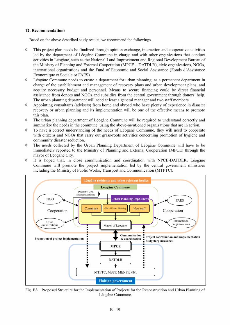
B - 19
12. Recommendations
Based on the above-described study results, we recommend the followings.
This project plan needs be finalized through opinion exchange, interaction and cooperative activities led by the department of Léogâne Commune in charge and with other organizations that conduct activities in Léogâne, such as the National Land Improvement and Regional Development Bureau of the Ministry of Planning and External Cooperation (MPCE – DATDLR), civic organizations, NGOs, international organizations and the Fund of Economic and Social Assistance (Fonds d’Assistance Economique et Sociale or FAES).
Léogâne Commune needs to create a department for urban planning, as a permanent department in charge of the establishment and management of recovery plans and urban development plans, and acquire necessary budget and personnel. Means to secure financing could be direct financial assistance from donors and NGOs and subsidies from the central government through donors’ help. The urban planning department will need at least a general manager and two staff members.
Appointing consultants (advisers) from home and abroad who have plenty of experience in disaster recovery or urban planning and its implementation will be one of the effective means to promote this plan.
The urban planning department of Léogâne Commune will be required to understand correctly and summarize the needs in the commune, using the above-mentioned organizations that are in action.
To have a correct understanding of the needs of Léogâne Commune, they will need to cooperate with citizens and NGOs that carry out grass-roots activities concerning promotion of hygiene and community disaster reduction.
The needs collected by the Urban Planning Department of Léogâne Commune will have to be immediately reported to the Ministry of Planning and External Cooperation (MPCE) through the mayor of Léogâne City.
It is hoped that, in close communication and coordination with NPCE-DATDLR, Léogâne Commune will promote the project implementation led by the central government ministries including the Ministry of Public Works, Transport and Communication (MTPTC).
Fig. B8 Proposed Structure for the Implementation of Projects for the Reconstruction and Urban Planning of
Léogâne Commune
MTPTC, MSPP, MENFP, etc.
MPCE
NGO
市民組織
FAES
国際組織
連絡・調整 プロジェクトの調整・実施
予算措置 プロジェクトの実施促進
Mayor of Léogâne
Léogâne Commune
レオガン市民等
「ハ」国政府
協調 協調 New staff Consultant
DATDLR
GM of Urban Planning
都市計画部署(新設) 土木局長
Civic organizations
International organizations Mayor of Léogâne
Cooperation
Cooperation
Director of Civil Engineering Bureau
Urban Planning Dept. (new)
Communication & coordination Promotion of project implementation Project coordination and implementation
Budgetary measures
Haitian government
Léogâne residents and other relevant bodies
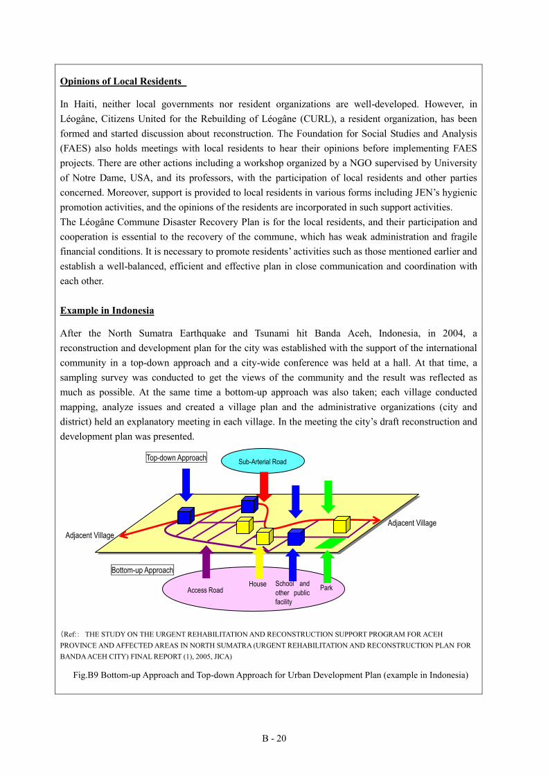
B - 20
Opinions of Local Residents
In Haiti, neither local governments nor resident organizations are well-developed. However, in Léogâne, Citizens United for the Rebuilding of Léogâne (CURL), a resident organization, has been formed and started discussion about reconstruction. The Foundation for Social Studies and Analysis (FAES) also holds meetings with local residents to hear their opinions before implementing FAES projects. There are other actions including a workshop organized by a NGO supervised by University of Notre Dame, USA, and its professors, with the participation of local residents and other parties concerned. Moreover, support is provided to local residents in various forms including JEN’s hygienic promotion activities, and the opinions of the residents are incorporated in such support activities. The Léogâne Commune Disaster Recovery Plan is for the local residents, and their participation and cooperation is essential to the recovery of the commune, which has weak administration and fragile financial conditions. It is necessary to promote residents’ activities such as those mentioned earlier and establish a well-balanced, efficient and effective plan in close communication and coordination with each other. Example in Indonesia
After the North Sumatra Earthquake and Tsunami hit Banda Aceh, Indonesia, in 2004, a reconstruction and development plan for the city was established with the support of the international community in a top-down approach and a city-wide conference was held at a hall. At that time, a sampling survey was conducted to get the views of the community and the result was reflected as much as possible. At the same time a bottom-up approach was also taken; each village conducted mapping, analyze issues and created a village plan and the administrative organizations (city and district) held an explanatory meeting in each village. In the meeting the city’s draft reconstruction and development plan was presented.
(Ref:: THE STUDY ON THE URGENT REHABILITATION AND RECONSTRUCTION SUPPORT PROGRAM FOR ACEH PROVINCE AND AFFECTED AREAS IN NORTH SUMATRA (URGENT REHABILITATION AND RECONSTRUCTION PLAN FOR BANDA ACEH CITY) FINAL REPORT (1), 2005, JICA)
Fig.B9 Bottom-up Approach and Top-down Approach for Urban Development Plan (example in Indonesia)
Adjacent Village
Park School and
other public
facility
House Access Road
Sub-Arterial Road Top-down Approach
Bottom-up Approach
Adjacent Village
B - 21
<Priority activities>
The following activities should be given priority for the reconstruction and development of Léogâne Commune.
Promotion of agriculture is the most important in Léogâne Commune. Agricultural development in devastated land should be conducted urgently in a way to contribute to the prevention of soil flowage while increasing agricultural production through the improvement of existing irrigation facilities and agricultural roads, educational activities of agricultural extension workers etc. Processing of agricultural products and foods, such as sugar, rum and juice, should be promoted.
Flood control measures should be give priority as the Rouyonne River often overflows and the western part of Léogâne City is covered with water. The measures should include afforestation in the upstream region (that will promote agricultural production), improvement of the Rouyonne River (bank improvement, dredging etc.) and replacement of the Vincent Bridge.
Improvement of access, water supply, drainage and electric power distribution is required for the recovery of the urban district of Léogâne. For the improvement of roads and drainage in the urban district, a project has been carried out with a Japanese grant aid. As for water supply, temporary recovery measures have been taken for the facilities in the city center through urgent rehabilitation work of this project. Water supply facilities will still have to be expanded and connected to more stable water sources. As for electricity, it is important to introduce renewable energy (solar power generation and small hydraulic power generation) and establish and implement a plan for stable operation of the electricity system.
It is important to reconstruct city office, schools, public health centers and other public facilities with quake-resistant structures so that they can be used as evacuation centers when a disaster occurs. It is also important to establish a prediction and alarm system for hurricanes and other disasters and prepare against natural disasters such as earthquake and flood on a daily basis. Moreover, community disaster reduction activities should be promoted to ensure prompt evacuation at the time of a disaster.
Léogâne has many educational facilities including a university that has been totally destroyed by the Great Haiti Earthquake, a nursing school and an agricultural school (currently planned). Educational facilities should be expanded through the reconstruction of these schools and introduction and attraction of new schools. Such actions will increase the number of students and teachers and expand related service demand.
Education is a basis for the whole country as well as individual personality. The public support system for education should be expanded.
C1 – 1
C. Rehabilitation project planning C1 Consideration of rehabilitation project planning
1. Consideration of priority rehabilitation projects (list of priority rehabilitation projects)
There is a tremendous need for long-term development in Haiti, and especially recovery from the earthquake damage is given high priority.
Considering such factors as necessity and urgency, activities and plans of donors and NGOs, especially feasibility based on the project scale, maintenance and sustainability, and acquisition of additional land lots, we have made a list of candidates for priority rehabilitation projects to be carried out with a Japanese grant aid in each sector. Fig.C1-1 shows the locations of these projects. 2. Evaluation of rehabilitation projects
We have evaluated the above-mentioned project plans in terms of beneficiary, maintainability, environmental and social considerations/land acquisition, characteristics/utilization of Japan's knowledge, overlap with projects of other donors, and necessity. 3. Priority rehabilitation projects
As a result of the above-mentioned study, the Project for Improvement of Urban Roads and Drainage for the Reconstruction of Léogâne City has been selected as a priority project to be carried out with a Japanese grant aid.
The details of this project will be described in the next section.
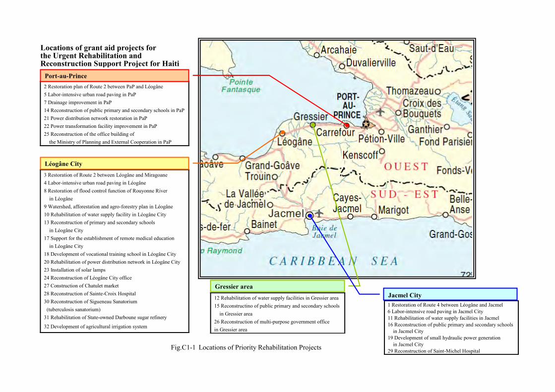
ハイチ国復興支援緊急プロジェクト
無償事業案位置図
2 Restoration plan of Route 2 between PaP and Léogâne 5 Labor-intensive urban road paving in PaP 7 Drainage improvement in PaP 14 Reconstruction of public primary and secondary schools in PaP 21 Power distribution network restoration in PaP 22 Power transformation facility improvement in PaP 25 Reconstruction of the office building of
the Ministry of Planning and External Cooperation in PaP
3 Restoration of Route 2 between Léogâne and Miragoane 4 Labor-intensive urban road paving in Léogâne 8 Restoration of flood control function of Rouyonne River
in Léogâne 9 Watershed, afforestation and agro-forestry plan in Léogâne 10 Rehabilitation of water supply facility in Léogâne City 13 Reconstruction of primary and secondary schools
in Léogâne City 17 Support for the establishment of remote medical education
in Léogâne City 18 Development of vocational training school in Léogâne City 20 Rehabilitation of power distribution network in Léogâne City 23 Installation of solar lamps 24 Reconstruction of Léogâne City office 27 Construction of Chatulet market 28 Reconstruction of Sainte-Croix Hospital 30 Reconstruction of Sigueneau Sanatorium (tuberculosis sanatorium) 31 Rehabilitation of State-owned Darboune sugar refinery
32 Development of agricultural irrigation system
1 Restoration of Route 4 between Léogâne and Jacmel 6 Labor-intensive road paving in Jacmel City 11 Rehabilitation of water supply facilities in Jacmel 16 Reconstruction of public primary and secondary schools
in Jacmel City 19 Development of small hydraulic power generation
in Jacmel City 29 Reconstruction of Saint-Michel Hospital
12 Rehabilitation of water supply facilities in Gressier area 15 Reconstructino of public primary and secondary schools
in Gressier area 26 Reconstruction of multi-purpose government office in Gressier area
Léogâne City
Port-au-Prince
Locations of grant aid projects for
the Urgent Rehabilitation and
Reconstruction Support Project for Haiti
Gressier area
Jacmel City
Fig.C1-1 Locations of Priority Rehabilitation Projects

C2 - 1
C2 Project for Improvement of Urban Roads and Drainage for the Reconstruction of Léogâne City
1. Background, history and outline of the project
1-1 Background and history The total distance of roads in Haiti is 3,572 kilometers and the distance per 1,000 people is 0.35
kilometers, much below the average of 7.1 kilometers in Latin America and the Caribbean (PDNA). In this situation, some donors such as the Inter-American Development Bank and the World Bank plan
to support the improvement of arterial roads connecting major cities, which has been required since before the earthquake.
Decentralization and local development to ease overconcentration in the capital has been an unsolved issue in Haiti since before the earthquake, and roads and road drainage in local cities are less developed compared with roads in the capital. Reconstruction of local cities that were severely damaged by the earthquake is especially an urgent task, and the country is required to improve infrastructure such as roads and drainage that will be the basis for such reconstruction.
Léogâne Commune, located about 35 kilometers west of the capital Port-au-Prince, was severely damaged by the Great Haiti Earthquake, with over 90% of the buildings collapsed. Urban streets were filled with rubble and temporary structures made by the victims and road access was blocked. Many of the collapsed buildings have been left untouched. Although U.N. agencies and other various NGOs have been conducting support activities, reconstruction of people's living is making very slow progress and the residents are having trouble making a living with no house or job.
Léogâne Commune has a total of 14.9 kilometers long urban roads, but they are mostly either unpaved or paved with asphalt that is severely damaged, except some roads with interlocking block paving. Such road condition prevents smooth access and has become a large adverse factor. There is also a problem with rain water drainage. Heavy rain causes floods in some areas, worsening sanitary conditions.
In Léogâne, which has vast flatland close to the capital, agriculture has developed in the delta area. Therefore, in Léogâne Commune, which is in the ideal location as a development base for decentralization, it is absolutely necessary to develop paved roads to secure access and traffic – the basis for sustainable reconstruction and development – in the urban area.
Based on the above-described background and history, the Haitian government has requested the Japanese government to provide support for improvement of major urban roads (about 11 kilometers) and dredging of existing drainage (2 kilometers) from the urban area to the coastline aimed to improve drainage in the urban area.
Mitigation of overconcentration in the capital Port-au-Prince has been an unsolved issue in Haiti since before the earthquake. The Action Plan for National Recovery and Development of Haiti (March 2010), developed based on PDNA, cites development of national land (urban development, restoration of road networks, development of regional bases etc.) as urgent recovery measures. Based on this, the overall goal of the project is the promotion of the reconstruction of Léogâne City, a development base close to the
C2 - 2
capital that is in great difficulty due to the natural disaster and economic distress. The purposes of the project are to improve traffic access through paving works in the urban area of
Léogâne City and to improve sanitary conditions through the improvement of drainage. 1-2 Outline of the project
This project aims to improve traffic access in the urban area of Léogâne by upgrading unpaved roads with interlocking block paving, for which residents’ labor power can be used. Asphalt paving will also be used for some roads with heavy traffic.
In addition to the improvement of urban roads, dredging and repair of the existing drainage channel from the urban area to the coastline should also be conducted so that drainage issues will be solved and then sanitary conditions will be improved.
Moreover, the project will promote reconstruction of people's lives in the affected area through the provision of cash income opportunities with employments for local residents. (1) Facilities to be developed
The following facilities will be constructed in the project.
General urban roads: Interlocking block paving and road drainage (about 10 kilometers) Heavy traffic roads: Asphalt paving and drainage (about 1 kilometer) Dredging of drainage: Dredging of existing drainage from the urban area to the coastline (about 2
kilometers)
(2) Road paving plan Existing road sections with interlocking block paving that were not affected by the Great Haiti
Earthquake (shown with yellow line in Fig. C1) will not be repaved but used as they are. Considering provision of employment opportunities in the area and maintainability after the completion
of the works, unpaved sections should be paved with interlocking blocks.
As the existing asphalt road sections have been quite damaged since before the Great Haiti Earthquake, they should be repaved. However, for the existing asphalt roads in the urban area, where the traffic volume seems smaller than national roads, interlocking block paving should be conducted like other roads in surrounding areas.
C2 - 3
Fig.C2-1 Paving Plan
Paving thickness has been set as below.
Table C2-1 Paving Thickness
Layer Asphalt paving Interlocking block paving
Surface layer Dense-graded asphalt concrete 4cm Interlocking block 9cm
Sand 5cm
Upper subbase Gravel for mechanical stabilization
15cm Gravel for mechanical stabilization 15cm
Lower subbase River gravel 30cm River gravel 30cm (3) Road drainage improvement plan
Rainwater drainage should be planned within the area of road paving improvement works to be conducted in this project.
Existing drainage channels should be used whenever possible after confirming there are sufficient cross-sectional flow areas to drain rainwater.
In the section of about 2 kilometers at the end of the rainwater drainage from the urban area to the coastline, dredging of waste and sediment will be carried out to facilitate discharge and create employments for neighboring residents.
0.5km
N [Legend]
Roads paved with interlocking blocks (new construction) Roads paved with interlocking blocks (existing) Asphalt road (rehabilitation)
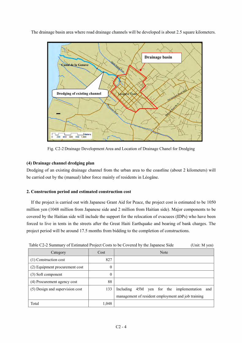
C2 - 4
The drainage basin area where road drainage channels will be developed is about 2.5 square kilometers.
Fig. C2-2 Drainage Development Area and Location of Drainage Chanel for Dredging
(4) Drainage channel dredging plan Dredging of an existing drainage channel from the urban area to the coastline (about 2 kilometers) will be carried out by the (manual) labor force mainly of residents in Léogâne.
2. Construction period and estimated construction cost
If the project is carried out with Japanese Grant Aid for Peace, the project cost is estimated to be 1050 million yen (1048 million from Japanese side and 2 million from Haitian side). Major components to be covered by the Haitian side will include the support for the relocation of evacuees (IDPs) who have been forced to live in tents in the streets after the Great Haiti Earthquake and bearing of bank charges. The project period will be around 17.5 months from bidding to the completion of constructions.
Table C2-2 Summary of Estimated Project Costs to be Covered by the Japanese Side (Unit: M yen)
Category Cost Note
(1) Construction cost 827
(2) Equipment procurement cost 0
(3) Soft component 0
(4) Procurement agency cost 88
(5) Design and supervision cost 133 Including 45M yen for the implementation and
management of resident employment and job training
Total 1,048
Dredging of existing channel
Canal de la Gonave
Drainage basin

C2 - 5
3. Project evaluation
The following effects are expected through the implementation of the project. Direct effect
The distance of paved roads in the urban area of Léogâne will increase from the current distance of 3,700 meters to 14,900 meters, and all the roads in the city center will be paved.
Provision of employment opportunities to the local residents (a total of about 8,000) will be facilitated and the livelihood of local residents will be improved.
Indirect effect As rainwater drainage in the urban area of Léogâne Commune will be improved, the sanitary
conditions for the residents will also be improved. As the reconstruction and development of Léogâne Commune will be facilitated, stable public
security and reconstruction and development of the society and economy will also be promoted.
As good access to public facilities etc. will be ensured, travel time will be reduced. Number of beneficiaries: The number of beneficiaries of this project is about 23,000 residents in the urban area of Léogâne. Most of the residents in the area will be covered.
Relevance and urgency: As the project aims to rebuild infrastructure in the area affected by the earthquake, it meets the purpose of Japanese grant aids concerning BHN, education and human resource development. Moreover, as the project is expected to contribute to the improvement of road infrastructure and employment situation of the residents of Léogâne City by supporting the reconstruction processes of Léogâne City, which was most severely damaged by the Great Haiti Earthquake, and carrying out debris removal and road improvement in labor-intensive methods, the relevance of the project implementation is high.
Operation and maintenance ability: The Haitian organizations have been conducting operation and maintenance for road facilities since before the earthquake and are deemed to have sufficient ability. Position in the recovery plan: This project is considered to be for the recovery of the affected areas, cited in the recovery plan. As it will also help infrastructure improvement in local cities to ease overconcentration in the capital, it is also considered to be for the preparation of basic conditions for regional base development described in the plan.
Profitability: Although the road project is expected to have major economic effects, there will be no direct financial benefit.
Environmental consideration: The road improvement in the plan will be repair of existing facilities. As problematic materials such as asbestos will not be used, there will be no negative health impact and will basically be no negative impact on the environment.
C2 - 6
Possibility of project implementation with Japanese grant aid: The project can be implemented with no particular difficulty in the scheme of Japanese grant aid for peace building (program type).
As observed above, the project will broadly contribute to the improvement of BHN of the residents and is also expected to have tremendous effects. As there is also a necessity for urgent road restoration, the relevance of a Japanese grant aid can be confirmed.
The Haitian side will have to ensure that structures occupying roads will be relocated from where construction will be carried out, or temporary moved to another road or a neighboring area, according to the construction schedule. It will also have to be ensured that operation and maintenance will be carried out after the service has started.
D - 1
D. Urgent Rehabilitation Project of Water Supply for Léogâne City Center
1. Position of the Project for Urgent Rehabilitation of the Water Supply System
The overall goal of the project is to support the resumption of economic activities and reconstruction of people's lives through the improvement of basic infrastructure in Léogâne Commune, which was seriously damaged by the earthquake. Therefore, the purposes of the project are to recover functions of the existing water supply facilities, to supply safe water to the residents in Léogâne, and to improve people’s lives, hygiene and health.
2. Current state of the sites for the urgent rehabilitation project
Léogâne Commune, located about 35 kilometers west of the capital Port-au-Prince, has a total population of about 157,000 (2003 census), 23,000 of which live in the urban district of Léogâne City.
3. Status of water use and existing water supply facilities
3-1 Status of water use As the existing water supply facilities in Léogâne Commune were totally destroyed by a hurricane in
2008 and the Great Haiti Earthquake, the residents in Léogâne Commune used water from shallow wells with a hand pump and water from water wagons arranged by NGOs. On the other hand, there are five private water vendors in the urban district of Léogâne City and it has become one of the means of water supply for drinking. 3-2 Status of existing water supply facilities
Major water sources for Léogâne Commune are Mapou Spring and La Porte Well, located about 7 kilometers southeast of the urban district of Léogâne City, and a public well located inside the urban district.
Fig.D1 shows the locations of the existing water supply facilities in Léogâne Commune. The facilities in Léogâne Commune, developed in 1988 with water from Mapou Spring, are not functioning any more. The distance of water distribution pipes is a total of about 25 kilometers and PVC (polyvinyl chloride) pipes are mainly used.

D - 2
N
0 2km 1
レオガン配水池 V: 320m3
ベルフォーチュン配水池 V: 70m3
マシュー配水池 V: 90m3
レオガン市街地
200mm管路(PVC)
配水池
湧水水源
凡例
150mm管路(PVC)
ラポルテ井戸 公共井戸
100mm管路(PVC)
75mm管路(PVC)
50mm管路(PVC)
25mm管路(PVC)
ハリケーン(2008 年)で損傷した 150mm管路(鋼管)
マプー湧水
Fig. D1 Locations of Existing Water Supply Facilities in Léogâne Commune
4. Selection of urgent rehabilitation projects
As the water supply conditions in Léogâne City were so poor, repair of the water distribution network in the City was an urgent task for DINEPA (National Water and Sanitation Bureau). The water wagon service failed to supply the amount of water required per person per day and forced people to bear inconvenience as they had to carry water to their house. Therefore, the functions of the existing facilities had to be restored as soon as possible.
Under such circumstances, in April 2010, the JICA research team for detailed design and the relevant Haitian organizations confirmed the implementation of Urgent Rehabilitation Project of Water Supply for Léogâne City Center. From May to June 2010, the JICA project consultation team also confirmed the implementation of a water supply project in Léogâne City, conducted as a project for urgent rehabilitation of the water supply system. From this project, synergetic effects of the goal of restoring water supply service in Léogâne City and the urgent projects by DINEPA itself were expected.
Based on the result of the investigation of urgent measures conducted by DINEPA, the research team considered the candidate projects for urgent rehabilitation and determined the contents of the projects through consultation with the project team and DINEPA.
The scopes of project implementation by the project team and DINEPA are as below.
Legend 200mm pipe (PVC) 150mm pipe (PVC) 100mm pipe (PVC) 75mm pipe (PVC) 50mm pipe (PVC) 25mm pipe (PVC) 150mm pipe damaged by a hurricane in 2008 Reservoir La Porte Well Public well Flowing well
Legend
Urban district of Léogâne City
Léogâne Distribution Reservoir V:320m3
Belle Fortune Distribution Reservoir V:70m3
Mattieu Distribution Reservoir V:90m3
Mapou Spring
New pipe installation by JICA
Public well
Repair by DINEPA
Fig.D2 Routs for New Pipe Installation by the Project Team
D - 3
(See Fig. D2.)
Scope of works by the project team: Replacement of water distribution pipes in the urban district of Léogâne City, installation of a submersible pump in the public well, and installation of public water taps
Scope of works by DINEPA: Leakage check and repair works of the existing channel from La Porte Well to Route 2 and some of the existing channels5 in the urban district of Léogâne City
5. Investigation of social and natural conditions
5-1 Base line survey concerning social conditions and water supply sanitation To contribute to the improvement of the water supply service in Léogâne City, we have collected basic
information concerning socioeconomic conditions and water use at the level of households in the city center. We have also conducted a sample survey 6 through interviews with 500 families, using a questionnaire, to understand the awareness of the residents concerning water use and water services. The results are as follows. (1) Household composition etc.
The average number of people per household is 5.4 with a male-to-female ratio of 4.7:5.3. The male-to-female ratio of household heads is 3.9:6.1 and the average age of household heads is 42.0. The residence form varies from owner-occupied house and rental, to temporary housing on property or in an evacuation camp, and tent.
(2) Working environment and income 47.2% of the households have at least one adult worker aged 18 or older. The employment rate of the
adult members aged 18 or older of the surveyed households is 18.3%, 51.7% of which have full employment. As for the daily income of the households with (a) working member(s), 56.3% of the households make 101 gourds (2.56 USD) to 500 gourds (12.8 USD), and the response rate was 67.2%.
As for the job category, tertiary industries that consist of retail, education, medical and welfare, and other service industries have the largest portion, i.e., 68.4%, of all the workers. Secondary industries that consist of construction industry have 25.6%, and agriculture, public service, NGO etc. account for the remaining 6%.
8.6% of the surveyed households receive pension or allowance, and 41.9% receive cash from home and abroad.
(3) Water consumption per unit and time required for water intake We have calculated the average water consumption per unit and the time required for water intake,
separately for the rainy season and the dry season. Results were 58.2 liters/person/day and 70 5 The distance of the pipes for DINEPA to repair has decreased due to the lack of qualified engineers to supervise leak tests and repair works of the pipes. 6 A sample survey is a method to presume characteristics of the population by surveying a limited number of samples selected from the population, while a census is a survey of all people in the population.
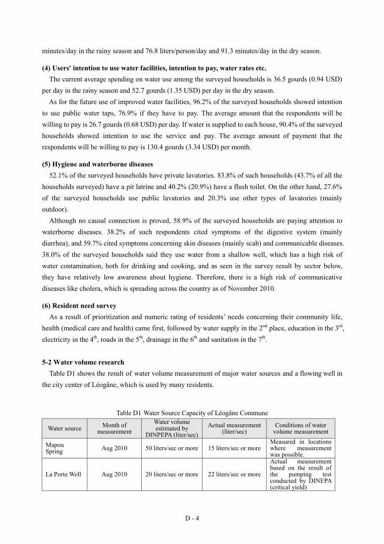
D - 4
minutes/day in the rainy season and 76.8 liters/person/day and 91.3 minutes/day in the dry season.
(4) Users' intention to use water facilities, intention to pay, water rates etc. The current average spending on water use among the surveyed households is 36.5 gourds (0.94 USD)
per day in the rainy season and 52.7 gourds (1.35 USD) per day in the dry season. As for the future use of improved water facilities, 96.2% of the surveyed households showed intention
to use public water taps, 76.9% if they have to pay. The average amount that the respondents will be willing to pay is 26.7 gourds (0.68 USD) per day. If water is supplied to each house, 90.4% of the surveyed households showed intention to use the service and pay. The average amount of payment that the respondents will be willing to pay is 130.4 gourds (3.34 USD) per month.
(5) Hygiene and waterborne diseases 52.1% of the surveyed households have private lavatories. 83.8% of such households (43.7% of all the
households surveyed) have a pit latrine and 40.2% (20.9%) have a flush toilet. On the other hand, 27.6% of the surveyed households use public lavatories and 20.3% use other types of lavatories (mainly outdoor).
Although no causal connection is proved, 58.9% of the surveyed households are paying attention to waterborne diseases. 38.2% of such respondents cited symptoms of the digestive system (mainly diarrhea), and 59.7% cited symptoms concerning skin diseases (mainly scab) and communicable diseases. 38.0% of the surveyed households said they use water from a shallow well, which has a high risk of water contamination, both for drinking and cooking, and as seen in the survey result by sector below, they have relatively low awareness about hygiene. Therefore, there is a high risk of communicative diseases like cholera, which is spreading across the country as of November 2010.
(6) Resident need survey As a result of prioritization and numeric rating of residents’ needs concerning their community life,
health (medical care and health) came first, followed by water supply in the 2nd place, education in the 3rd, electricity in the 4th, roads in the 5th, drainage in the 6th and sanitation in the 7th.
5-2 Water volume research
Table D1 shows the result of water volume measurement of major water sources and a flowing well in the city center of Léogâne, which is used by many residents.
Table D1 Water Source Capacity of Léogâne Commune
Water source Month of measurement
Water volume estimated by
DINPEPA (liter/sec) Actual measurement
(liter/sec) Conditions of water
volume measurement
Mapou Spring Aug 2010 50 liters/sec or more 15 liters/sec or more
Measured in locations where measurement was possible.
La Porte Well Aug 2010 20 liters/sec or more 22 liters/sec or more
Actual measurement based on the result of the pumping test conducted by DINEPA (critical yield)

D - 5
Water source Month of measurement
Water volume estimated by
DINPEPA (liter/sec) Actual measurement
(liter/sec) Conditions of water
volume measurement
Public well Aug 2010 N.A.
17 liters/sec or more (For reference,
measurement by JICA in May was 8
liters/sec.)
Water level was stable from the ground level to 2.8 meters when water is pumped at 17 liters/sec.
Flowing well Sep 2010 N.A. 0.5 liters/sec Measured with 20-liter cans
5-3 Water quality analysis As a result of simple analysis of 15 water quality test items, coliform was detected in the water from
the flowing well and the turbidity was slightly higher than the WHO guideline value for drinking water. The water quality of the public well was good.
As a result of a laboratory analysis of 36 items, coliform was detected twice in the water from Mapou Spring, but the public well and La Porte Well met the WHO guideline for drinking water. Mapou Spring will need disinfection facilities before it can be used as a water source.
6. Planning and design of Urgent Rehabilitation Project of Water Supply for Léogâne City
Center
6-1 Outline of the urgent rehabilitation project Based on the agreement with and approval of DINEPA, the project aims to restore the functions of the
existing water supply facilities as a project for urgent rehabilitation that is expected to contribute to rebuilding people's lives in Léogâne City.
The number of beneficiaries of Urgent Rehabilitation Project of Water Supply for Léogâne City Center is about 9,000. The number is expected to be about 22,000 if water is supplied from La Porte Well. Fig. D3 shows the scope of works of the project for urgent rehabilitation of water supply by the Japanese side and the scope of works by DINEPA.
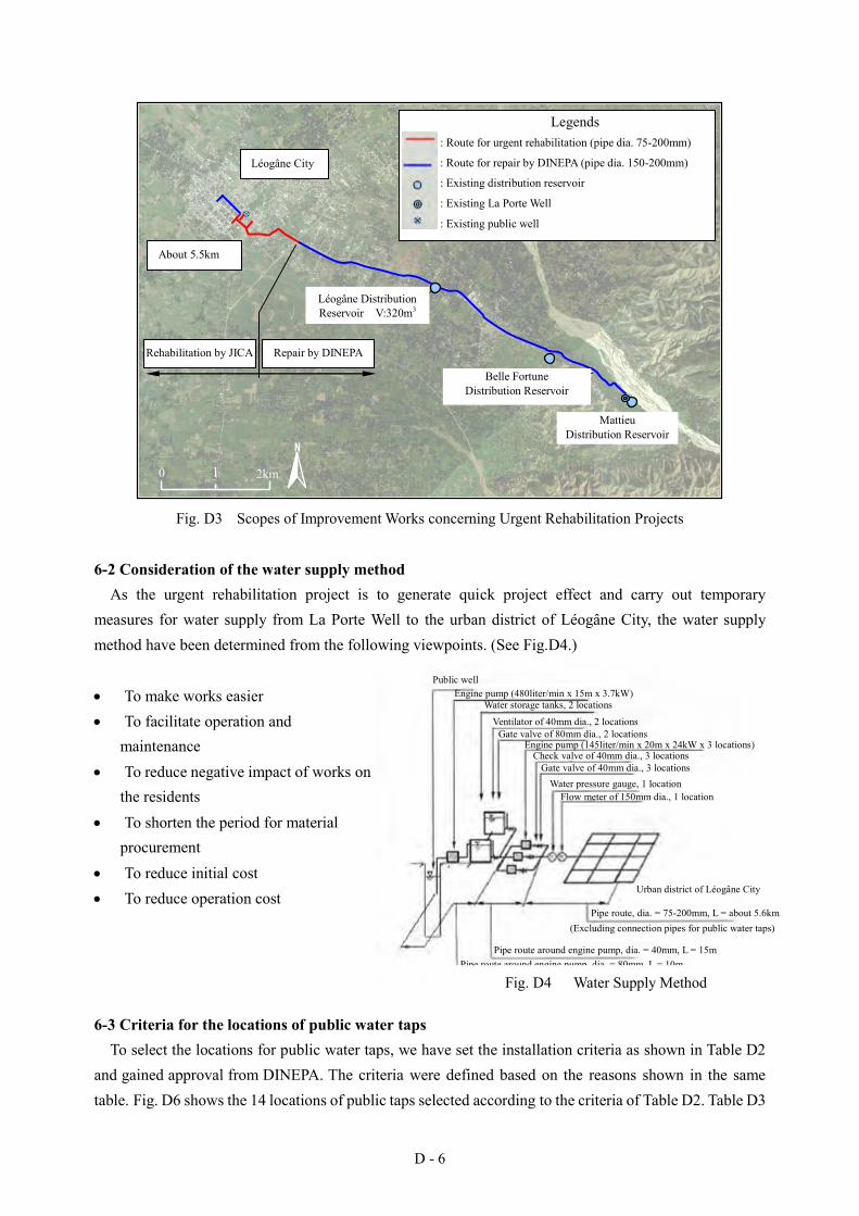
D - 6
N
0 2km 1
ベル・フォーチュン 配水池
マシュー
配水池
:既存配水池
Legends :緊急リハビリ管路(管径 75-200mm)
:既存ラポルテ井戸 :既存公共井戸
レオガン市街地
レ オ ガ ン 配水池 V:320m3
:DINEPAによる補修管路(管径 150-200mm)
約 5.5km
DINEPAの補修範囲 JICAリハビリ範囲
Fig. D3 Scopes of Improvement Works concerning Urgent Rehabilitation Projects
6-2 Consideration of the water supply method As the urgent rehabilitation project is to generate quick project effect and carry out temporary
measures for water supply from La Porte Well to the urban district of Léogâne City, the water supply method have been determined from the following viewpoints. (See Fig.D4.)
To make works easier To facilitate operation and
maintenance To reduce negative impact of works on
the residents To shorten the period for material
procurement To reduce initial cost To reduce operation cost
6-3 Criteria for the locations of public water taps To select the locations for public water taps, we have set the installation criteria as shown in Table D2
and gained approval from DINEPA. The criteria were defined based on the reasons shown in the same table. Fig. D6 shows the 14 locations of public taps selected according to the criteria of Table D2. Table D3
Urban district of Léogâne City
Pipe route, dia. = 75-200mm, L = about 5.6km (Excluding connection pipes for public water taps)
Pipe route around engine pump, dia. = 40mm, L = 15m Pipe route around engine pump, dia. = 80mm, L = 10m
Public well Engine pump (480liter/min x 15m x 3.7kW)
Water storage tanks, 2 locations
Ventilator of 40mm dia., 2 locations Gate valve of 80mm dia., 2 locations
Engine pump (145liter/min x 20m x 24kW x 3 locations) Check valve of 40mm dia., 3 locations
Gate valve of 40mm dia., 3 locations Water pressure gauge, 1 location
Flow meter of 150mm dia., 1 location
Legends : Route for urgent rehabilitation (pipe dia. 75-200mm)
: Route for repair by DINEPA (pipe dia. 150-200mm)
: Existing distribution reservoir
: Existing La Porte Well
: Existing public well
Léogâne City
About 5.5km
Rehabilitation by JICA Repair by DINEPA
Léogâne Distribution Reservoir V:320m3
Belle Fortune Distribution Reservoir
Mattieu
Distribution Reservoir
Fig. D4 Water Supply Method

D - 7
shows the reasons for the selection of these locations.
Table D2 Criteria for Locations of Public Water Taps and Reasons Installation criteria Reason
A. Location where a plastic water storage tank has been installed
Save the Children, a NGO, installed the tanks to improve people's convenience after the earthquake.
B. Location of existing public taps The locations of existing public taps are considered convenient for the residents.
C. Area with many schools, health centers etc. Important public facilities D. Area with no shallow well with a hand
pump It is considered that such areas do not have enough
water sources. E. Area with an evacuee camp There is no water source around the camp.
(Data from JICA research team)
Table D3 Criteria for Locations of Public Water Taps Public water tap (P.T.)
No. Selection criteria Public water tap (P.T.) No. Selection criteria
1. E 8. B 2. D 9. D 3. A 10. C 4. C 11. B 5. A 12. C 6. A 13. D 7. A 14. C
(Data from JICA research team)
DINEPA had a plan for future water facility development with the target year set at 2030, for which
they planned to start a feasibility study. As installation of public taps that anybody can freely use might cause operation and maintenance issues, they had a policy to not develop public taps. Therefore, instead of 14 locations in publicly-owned land, installation of public taps in 6 locations on the premises of public schools has been decided. Finally, it has been decided to install public taps in 12 locations, including 6 locations for additional extension works, on school premises as shown in Table D4. We made the final decision concerning the locations of public taps through additional extension works after checking the installation space of the public taps on school property and convenience for the users based on the request from DINEPA and schools.
Table D4 Schools where Public Water Taps will be Installed
No. School Address No. of students (as of Oct 2010)
P.T.1 École Nationale de Filles Rue Saint Yves 325 P.T.2 École Nationale Mixte de Léogâne Grand Rue 438
P.T.3&4 École Louis Bornó Face Place Anacaona 800 P.T.5 College Coeur de Marie Sainte Rose de Lima Montée Rue Saint Croix 645
(P.T.6) Joyeux Soleil Kindergarden Grand Rue 330 P.T.7 Lycée Anacaona Route Nationale # 2 2,500
(P.T.8) Institute Sainte Marie Rue d'Enfer et Rue la Croix 150 (P.T.9) École Enfants de Myriame Rue d'Enfer 100
(P.T.10) Centre d'Etudes Montaigne rue la Croix 263 (P.T.11) Petit Mignon Rue d'Enfer 700 (P.T.12) École Surein Eveillard Rue d'Enfer 750
Note: Public taps in brackets were added for extension works.

D - 8
6-4 Points to consider for spec determination based on the future water demand Having a future concept for 2030, DINEPA started a feasibility study in major cities of the country in
March 2010 and is now conducting the study in places including Léogâne. We have considered whether the functions of the facilities to be improved through this urgent rehabilitation projects can still be used in 2030 and determined the specifications so that the capacity of distribution pipes etc. can handle the pumping discharge from La Porte Well and the water demand in 2030. We considered specifications in the following procedures.
A. Confirmation of the pumping capacity of La Porte Well B. Hydraulic analysis based on the pumping discharge of La Porte Well C. Water demand forecast for 2030 D. Hydraulic analysis with the water demand forecast for 2030 E. Evaluation of the validity of the hydraulic analysis of B, based on the result of the analysis of D
As seen in Fig. D5, the planned pipe diameters of QIP will still be good in 2030.
凡例
φ200mm (8”)
φ150mm (6”)
φ100mm (4”)
φ75mm (3”)
締め切りバルブ
緊急リハビリ管路
Not to Scale
Fig. D5 Planned Pipe Diameters in the Pipe Line Plan of QIP for 2030
Legends
Dia. 200mm (8”)
Dia. 150mm (6”)
Dia. 100mm (4”)
Dia. 75mm (3”)
Block valve Route for urgent rehabilitation
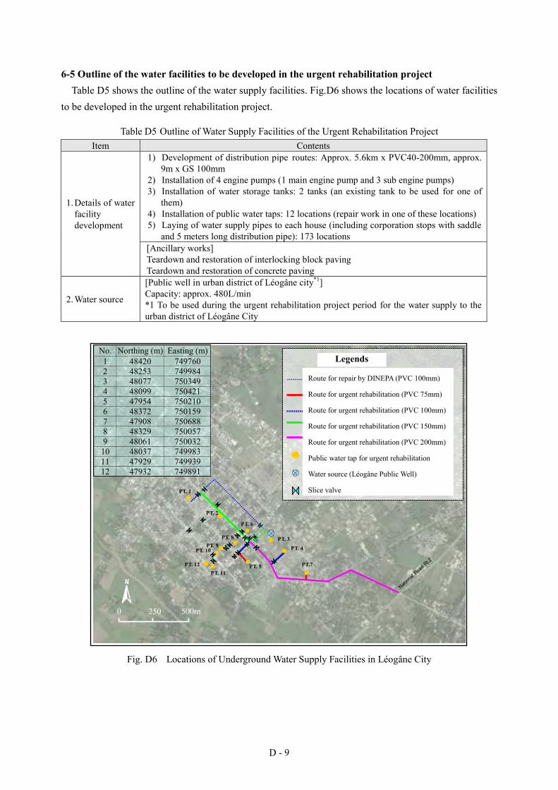
D - 9
6-5 Outline of the water facilities to be developed in the urgent rehabilitation project Table D5 shows the outline of the water supply facilities. Fig.D6 shows the locations of water facilities
to be developed in the urgent rehabilitation project.
Table D5 Outline of Water Supply Facilities of the Urgent Rehabilitation Project Item Contents
1. Details of water facility development
1) Development of distribution pipe routes: Approx. 5.6km x PVC40-200mm, approx. 9m x GS 100mm
2) Installation of 4 engine pumps (1 main engine pump and 3 sub engine pumps) 3) Installation of water storage tanks: 2 tanks (an existing tank to be used for one of
them) 4) Installation of public water taps: 12 locations (repair work in one of these locations) 5) Laying of water supply pipes to each house (including corporation stops with saddle
and 5 meters long distribution pipe): 173 locations [Ancillary works] Teardown and restoration of interlocking block paving Teardown and restoration of concrete paving
2. Water source
[Public well in urban district of Léogâne city*1] Capacity: approx. 480L/min *1 To be used during the urgent rehabilitation project period for the water supply to the urban district of Léogâne City
N
緊急リハビリ管路(PVC100mm)
水源(レオガン公共井戸)
緊急リハビリ公共水栓
凡例
緊急リハビリ管路(PVC150mm)
DINEPA による補修管路(PVC100mm)
緊急リハビリ管路(PVC200mm)
PT. 3
PT. 1
PT. 5
PT. 4
仕切弁
0 500m 250
PT.7
PT. 2
PT. 6
PT. 8 PT. 9
PT. 10
PT. 11 PT. 12
緊急リハビリ管路(PVC75mm)
No. Northing (m) Easting (m)1 48420 7497602 48253 7499843 48077 7503494 48099 7504215 47954 7502106 48372 7501597 47908 7506888 48329 7500579 48061 750032
10 48037 74998311 47929 74993912 47932 749891
Nation
al Ro
ad R
t.2
Fig. D6 Locations of Underground Water Supply Facilities in Léogâne City
Legends
Route for repair by DINEPA (PVC 100mm)
Route for urgent rehabilitation (PVC 75mm)
Route for urgent rehabilitation (PVC 100mm)
Route for urgent rehabilitation (PVC 150mm)
Route for urgent rehabilitation (PVC 200mm)
Public water tap for urgent rehabilitation
Water source (Léogâne Public Well)
Slice valve

D - 10
6-6 Basic policy of operation and maintenance
(1) Basic policy of operation and maintenance As most of the components of this rehabilitation project are improvement works of water supply
facilities (with some exceptional works of common water tap construction) for future water supply to each house with permanent facilities, we have created technical and financial manuals and guidelines and provided various supports and guidance concerning operation processes, registration and connection procedures etc., as described in the next section. It is deemed appropriate that support was provided for the establishment of an operation and maintenance system based on water supply to each house, because SNEP (National Service for Drinking Water) has had a paid service of water supply to each house in Léogâne and as much as 90% of the respondents of the baseline survey are willing to use and pay for water supply to their house.
(2) Contents and outputs of technical supports concerning operation and maintenance We provided guidance concerning operation and maintenance of the water supply facilities to be
constructed through the urgent rehabilitation project to a total of seven people including a regular member of DINEPA Léogâne of Léogâne CTE and some candidates for future staff. However, OJT was not carried out as the facilities and equipment were neither completed nor operated at that time. Instead, we provided training using manuals. Despite this, the personnel, including former staff of SNEP Léogâne, were considered to have sufficient ability to conduct technical operation and maintenance for the water facilities to be constructed through the urgent rehabilitation project. The contents and outputs of the supports are as described below.
Contents and Outputs of Technical Cooperation concerning Operation and Maintenance
Contents of support
- Development of operation and maintenance manual - Operation and maintenance training of DINEPA staff with the above-stated manual - Support to hold an explanation meeting for residents concerning the use of public water service, preparation of meeting materials and kits
Output
- Operation and maintenance manual (See the reference material of the main report) - Various training of a total of 7 people including a staff member of DINEPA and candidates for future staff (e.g., organizational structure, rate collection processes, account opening, accounting forms, registration and connection procedures, ledger management, PR, emergency response, water supply flow, facilities and equipment, operation processes, meter reading, disinfection by chlorine, monitoring and recording)
- Explanatory meeting for residents concerning the use of public water supply system (about 70 participants)
As of August 2011, CTE is processing contract with beneficiaries and restarting water supply service for
those who have signed the contract.
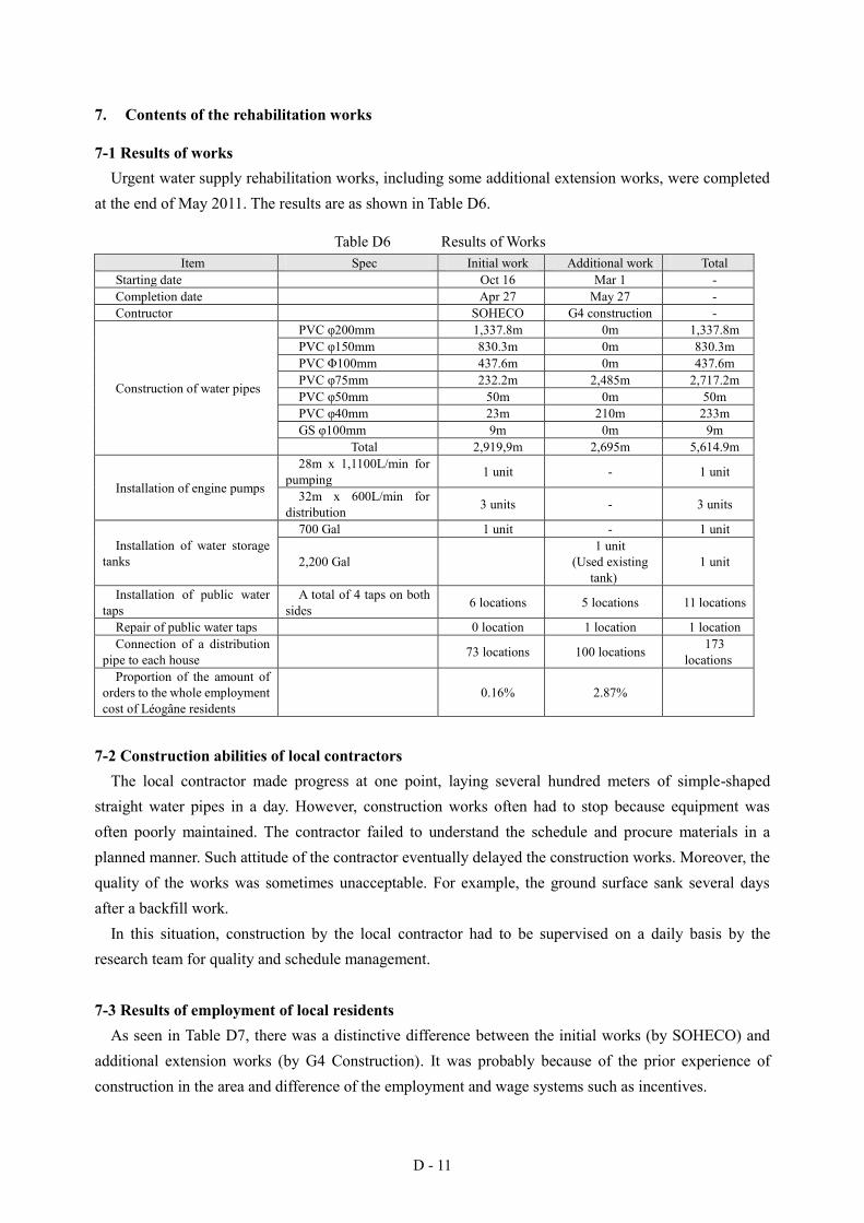
D - 11
7. Contents of the rehabilitation works
7-1 Results of works Urgent water supply rehabilitation works, including some additional extension works, were completed
at the end of May 2011. The results are as shown in Table D6.
Table D6 Results of Works Item Spec Initial work Additional work Total
Starting date Oct 16 Mar 1 - Completion date Apr 27 May 27 - Contructor SOHECO G4 construction -
Construction of water pipes
PVC φ200mm 1,337.8m 0m 1,337.8m PVC φ150mm 830.3m 0m 830.3m PVC Φ100mm 437.6m 0m 437.6m PVC φ75mm 232.2m 2,485m 2,717.2m PVC φ50mm 50m 0m 50m PVC φ40mm 23m 210m 233m GS φ100mm 9m 0m 9m
Total 2,919,9m 2,695m 5,614.9m
Installation of engine pumps
28m x 1,1100L/min for pumping 1 unit - 1 unit
32m x 600L/min for distribution 3 units - 3 units
Installation of water storage tanks
700 Gal 1 unit - 1 unit
2,200 Gal 1 unit
(Used existing tank)
1 unit
Installation of public water taps
A total of 4 taps on both sides 6 locations 5 locations 11 locations
Repair of public water taps 0 location 1 location 1 location Connection of a distribution
pipe to each house 73 locations 100 locations 173 locations
Proportion of the amount of orders to the whole employment cost of Léogâne residents
0.16% 2.87%
7-2 Construction abilities of local contractors The local contractor made progress at one point, laying several hundred meters of simple-shaped
straight water pipes in a day. However, construction works often had to stop because equipment was often poorly maintained. The contractor failed to understand the schedule and procure materials in a planned manner. Such attitude of the contractor eventually delayed the construction works. Moreover, the quality of the works was sometimes unacceptable. For example, the ground surface sank several days after a backfill work.
In this situation, construction by the local contractor had to be supervised on a daily basis by the research team for quality and schedule management.
7-3 Results of employment of local residents As seen in Table D7, there was a distinctive difference between the initial works (by SOHECO) and
additional extension works (by G4 Construction). It was probably because of the prior experience of construction in the area and difference of the employment and wage systems such as incentives.

D - 12
As the construction came toward the end, the number of local residents employed became fewer and fewer for both, finally reaching zero at the time of the installation of interlocking blocks, for which local labor force was expected to be used most. It was probably because they had to meet the schedule and there was no time to employ local residents.
Table D7 Results of Employment of Local Residents SOHECO G4 Construction
Proportion of cost for employment of local residents to the total order amount
0.16% 2.87%
No. of local residents employed per day 0.58 7.59
Public water tap at primary school Public water tap at primary school
Water storage tank Engine pumps for water distribution
Photos at the Time of Completion (May 2011)
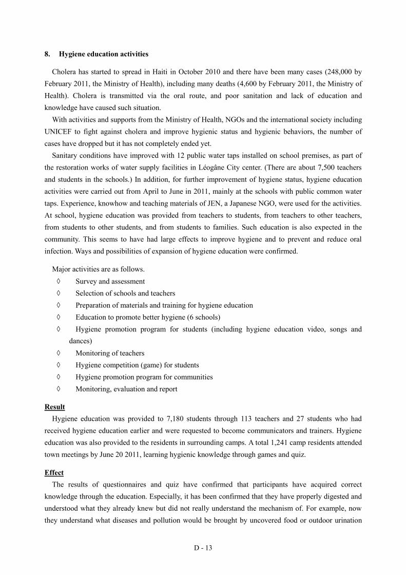
D - 13
8. Hygiene education activities
Cholera has started to spread in Haiti in October 2010 and there have been many cases (248,000 by February 2011, the Ministry of Health), including many deaths (4,600 by February 2011, the Ministry of Health). Cholera is transmitted via the oral route, and poor sanitation and lack of education and knowledge have caused such situation.
With activities and supports from the Ministry of Health, NGOs and the international society including UNICEF to fight against cholera and improve hygienic status and hygienic behaviors, the number of cases have dropped but it has not completely ended yet.
Sanitary conditions have improved with 12 public water taps installed on school premises, as part of the restoration works of water supply facilities in Léogâne City center. (There are about 7,500 teachers and students in the schools.) In addition, for further improvement of hygiene status, hygiene education activities were carried out from April to June in 2011, mainly at the schools with public common water taps. Experience, knowhow and teaching materials of JEN, a Japanese NGO, were used for the activities. At school, hygiene education was provided from teachers to students, from teachers to other teachers, from students to other students, and from students to families. Such education is also expected in the community. This seems to have had large effects to improve hygiene and to prevent and reduce oral infection. Ways and possibilities of expansion of hygiene education were confirmed.
Major activities are as follows. Survey and assessment Selection of schools and teachers Preparation of materials and training for hygiene education Education to promote better hygiene (6 schools) Hygiene promotion program for students (including hygiene education video, songs and
dances) Monitoring of teachers Hygiene competition (game) for students Hygiene promotion program for communities Monitoring, evaluation and report
Result Hygiene education was provided to 7,180 students through 113 teachers and 27 students who had
received hygiene education earlier and were requested to become communicators and trainers. Hygiene education was also provided to the residents in surrounding camps. A total 1,241 camp residents attended town meetings by June 20 2011, learning hygienic knowledge through games and quiz.
Effect The results of questionnaires and quiz have confirmed that participants have acquired correct
knowledge through the education. Especially, it has been confirmed that they have properly digested and understood what they already knew but did not really understand the mechanism of. For example, now they understand what diseases and pollution would be brought by uncovered food or outdoor urination
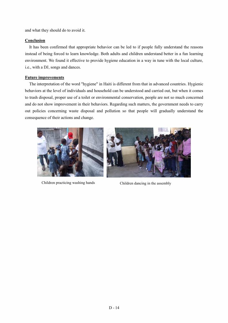
D - 14
and what they should do to avoid it.
Conclusion It has been confirmed that appropriate behavior can be led to if people fully understand the reasons
instead of being forced to learn knowledge. Both adults and children understand better in a fun learning environment. We found it effective to provide hygiene education in a way in tune with the local culture, i.e., with a DJ, songs and dances.
Future improvements The interpretation of the word "hygiene" in Haiti is different from that in advanced countries. Hygienic
behaviors at the level of individuals and household can be understood and carried out, but when it comes to trash disposal, proper use of a toilet or environmental conservation, people are not so much concerned and do not show improvement in their behaviors. Regarding such matters, the government needs to carry out policies concerning waste disposal and pollution so that people will gradually understand the consequence of their actions and change.
Children dancing in the assembly
Children practicing washing hands Children practicing washing hands Children dancing in the assembly