Embed Size (px)
Citation preview

Road Safety Audit US 20 (Albany-Corvallis Highway No. 31) at Independence Highway and Granger Avenue, Benton County
Page i
Road Safety Audit Report
US 20 Road Safety Audit
Prepared For:
Oregon Department of Transportation
455 Airport Road SE, Building B
Salem, OR 97301-5395
United States of America
Prepared by:
DKS Associates
117 Commercial Street NE, Suite 310
Salem, Oregon 97301
ODOT Project Manager: Amanda Westmoreland Consultant Project Manager: Scott Mansur, P.E., PTOE Consultant Project Engineer: Michael Tomasini, P.E., PTOE April, 2012
Albany-Corvallis Highway No.31 Benton County, Oregon
Independence Highway (M.P. 6.41) Granger Avenue (M.P. 5.63)

US 20 Road Safety Audit Albany-Corvallis Highway No. 31
Benton County, Oregon
Independence Highway (M.P. 6.41)
Granger Avenue (M.P. 5.63)
Audit Dates: March 19-20, 2012
Road Safety Audit US 20 (Albany-Corvallis Highway No. 31) at Independence Highway and Granger Avenue, Benton County
Page ii
THIS DOCUMENT IS PROTECTED
UNDER THE PROVISIONS OF TITLE 23 UNITED STATES CODE SECTION 409 AS FOLLOWS:
Title 23 U.S.C. § 409
Discovery and admission as evidence of certain reports and surveys
Notwithstanding any other provision of law, reports, surveys, schedules, lists or data compiled or col-
lected for the purpose of identifying, evaluating, or planning the safety enhancement of potential acci-
dent sites, hazardous roadway conditions, or railway-highway crossings, pursuant to sections 130, 144
and 148 of this title or for the purpose of developing any highway safety construction improvement
project which may be implemented utilizing Federal-aid highway funds shall not be subject to discovery
or admitted into evidence in a Federal or State court proceeding or considered for other purposes in
any action for damages arising from any occurrence at a location mentioned or addressed in such re-
ports, surveys, schedules, lists or data.
Road Safety Audit US 20 (Albany-Corvallis Highway No. 31) at Independence Highway and Granger Avenue, Benton County
Page iii
Road Safety Audit Summary
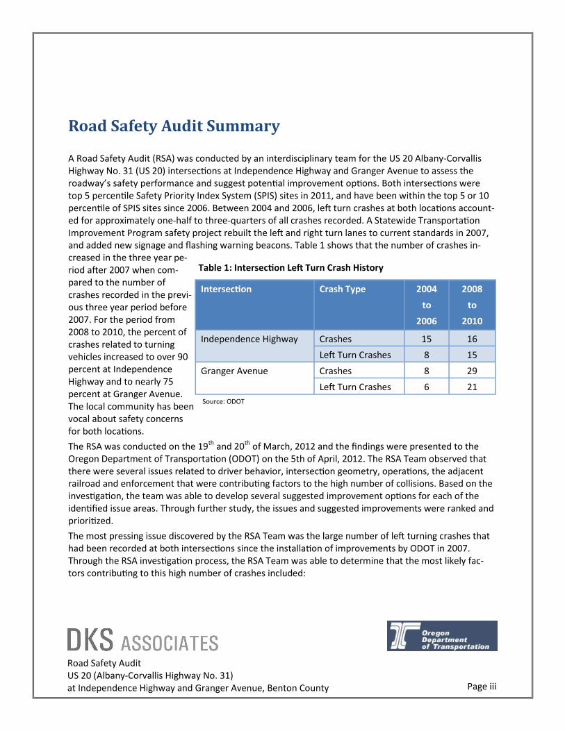
A Road Safety Audit (RSA) was conducted by an interdisciplinary team for the US 20 Albany-Corvallis Highway No. 31 (US 20) intersections at Independence Highway and Granger Avenue to assess the roadway’s safety performance and suggest potential improvement options. Both intersections were top 5 percentile Safety Priority Index System (SPIS) sites in 2011, and have been within the top 5 or 10 percentile of SPIS sites since 2006. Between 2004 and 2006, left turn crashes at both locations account-ed for approximately one-half to three-quarters of all crashes recorded. A Statewide Transportation Improvement Program safety project rebuilt the left and right turn lanes to current standards in 2007, and added new signage and flashing warning beacons. Table 1 shows that the number of crashes in-creased in the three year pe-riod after 2007 when com-pared to the number of crashes recorded in the previ-ous three year period before 2007. For the period from 2008 to 2010, the percent of crashes related to turning vehicles increased to over 90 percent at Independence Highway and to nearly 75 percent at Granger Avenue. The local community has been vocal about safety concerns for both locations.
The RSA was conducted on the 19th and 20th of March, 2012 and the findings were presented to the Oregon Department of Transportation (ODOT) on the 5th of April, 2012. The RSA Team observed that there were several issues related to driver behavior, intersection geometry, operations, the adjacent railroad and enforcement that were contributing factors to the high number of collisions. Based on the investigation, the team was able to develop several suggested improvement options for each of the identified issue areas. Through further study, the issues and suggested improvements were ranked and prioritized.
The most pressing issue discovered by the RSA Team was the large number of left turning crashes that had been recorded at both intersections since the installation of improvements by ODOT in 2007. Through the RSA investigation process, the RSA Team was able to determine that the most likely fac-tors contributing to this high number of crashes included:
Intersection Crash Type 2004
to
2006
2008
to
2010
Crashes 15 16 Independence Highway
Left Turn Crashes 8 15
Granger Avenue Crashes 8 29
Left Turn Crashes 6 21
Table 1: Intersection Left Turn Crash History
Source: ODOT

Road Safety Audit US 20 (Albany-Corvallis Highway No. 31) at Independence Highway and Granger Avenue, Benton County
Page iv
Driver Behavior: Road rage, impatient drivers, failure to stop for the stop sign and illegal left turns
were behaviors the RSA Team witnessed and associated with the high number of crashes at these
locations.
Operations: High traffic volumes, limited gaps and high side street delay were seen as contributing
factors by the RSA Team to many of the observed driver behaviors.
Geometry: Due to the configuration of the right turn lanes on US 20, vehicles turning onto Independ-
ence Highway or Granger Avenue block the view of oncoming traffic for vehicles trying to enter US
20 from the side street. This situation was also seen by the RSA Team as a significant contributing
factor to the left turning crashes at these locations.
Any one of these factors by themselves would not likely lead to an increase in crash frequency. Howev-er, the RSA Team has found that the likely explanation for the increase in crashes at the US 20 intersec-tions at Independence Highway and Granger Avenue was the combination of all three.
Road Safety Audit US 20 (Albany-Corvallis Highway No. 31) at Independence Highway and Granger Avenue, Benton County
March 19-20, 2012 Page 1
RSA Process
RSAs are conducted by an interdisciplinary team to
assess a roadway’s safety performance and suggest
potential improvement options. RSAs help improve
road safety by identifying present and future safety
issues, as well as promoting awareness of safe design,
operational and maintenance practices. RSAs also
support consideration of multimodal approaches to
safety, and include human factors in safety needs as-
sessment and solution development.
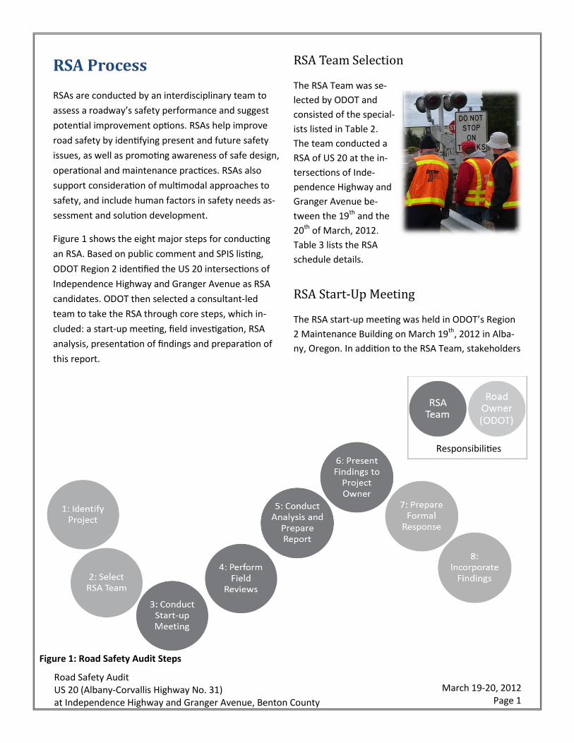
Figure 1 shows the eight major steps for conducting
an RSA. Based on public comment and SPIS listing,
ODOT Region 2 identified the US 20 intersections of
Independence Highway and Granger Avenue as RSA
candidates. ODOT then selected a consultant-led
team to take the RSA through core steps, which in-
cluded: a start-up meeting, field investigation, RSA
analysis, presentation of findings and preparation of
this report.
RSA Team Selection
The RSA Team was se-
lected by ODOT and
consisted of the special-
ists listed in Table 2.
The team conducted a
RSA of US 20 at the in-
tersections of Inde-
pendence Highway and
Granger Avenue be-
tween the 19th and the
20th of March, 2012.
Table 3 lists the RSA
schedule details.
RSA Start-Up Meeting
The RSA start-up meeting was held in ODOT’s Region
2 Maintenance Building on March 19th, 2012 in Alba-
ny, Oregon. In addition to the RSA Team, stakeholders
Responsibilities
Figure 1: Road Safety Audit Steps

Road Safety Audit US 20 (Albany-Corvallis Highway No. 31) at Independence Highway and Granger Avenue, Benton County
March 19-20, 2012 Page 2
Name Agency Specialty
Scott Mansur, P.E., PTOE DKS Associates RSA Team Leader – Transportation Planning, Engineering, Safety and Operations
Michael Tomasini, P.E., PTOE DKS Associates Transportation Planning, Engineering, Safety and Operations
Amanda Westmoreland ODOT Traffic Safety & Project Resource/Coordinator
Wade Coatney ODOT Roadway Design
David Stearns ODOT Striping Maintenance
Anne Holder ODOT Traffic Safety/Human Factors
Dave Hacek ODOT Sign Crew Coordinator
Laurel Byer, P.E. Benton County County Engineer
Ron Keil, P.E. OSU OSU Engineering Professor and User
Table 2: Road Safety Audit Team
Table 3: Road Safety Audit Schedule
Monday March 19, 2012
9:00 am to 10:30 am Pre Audit Meeting/RSA Team Training
10:30 am to 12:30 pm Field Conditions Observations
12:30 pm to 1:30 pm Lunch
1:30 pm to 3:00 pm Debrief/Break
3:00 pm to 4:00 pm Field Conditions Observations
4:00 pm to 5:30 pm Peak Hour Observations
5:30 pm to 6:30 pm Dinner
6:30 pm to 9:00 pm Evening Observations
Tuesday March 20, 2012
7:00 am to 9:00 am Morning Peak Hour Observations
9:00 am to 12:00 pm Review Field Notes, Technical Information, and Debrief
12:00 am to 1:30 pm Lunch
1:30 pm to 3:30 pm Document Issues Observed, Trends, Factors
3:30 pm to 5:00 pm Brainstorm Suggested Mitigations
Wednesday March 21, 2012
9:00 am to 12:00 pm Conduct Audit Analysis and Prepare Findings Presentation
12:00 pm to 1:00 pm Lunch
1:00 pm to 3:00 pm Conduct Audit Analysis and Prepare Findings Presentation
3:00 pm to 5:00 pm Presentation to ODOT (Canceled due to Snow)
Thursday April 5, 2012
3:00 pm to 5:00 pm Presentation to ODOT and Stakeholders
Road Safety Audit US 20 (Albany-Corvallis Highway No. 31) at Independence Highway and Granger Avenue, Benton County
March 19-20, 2012 Page 3
in attendance included representatives from ODOT
Area Management, ODOT Region 2 Traffic, the Ore-
gon Highway Patrol, Benton County Sheriff’s Office,
Oregon State University, Albany school districts, the
local Area Council on Transportation and two neigh-
borhood groups. The RSA Team and Stakeholders
were given a presentation to inform them of the ex-
isting site conditions, including: surrounding land us-
es, motor vehicle volumes, crash records, speed sur-
vey results and previous intersection improvement
efforts. The RSA Team was then given additional RSA
training before heading out to the field to investigate
the two intersections.
RSA Field Investigation
The RSA Team observed and investigated the two in-
tersections during peak and off-peak hours under var-
ious lighting and weather conditions on the 19th and
20th of March, 2012. Observations focused on the
roadway and roadside environment, existing roadway
geometry, motor vehicle operations, driver behaviors
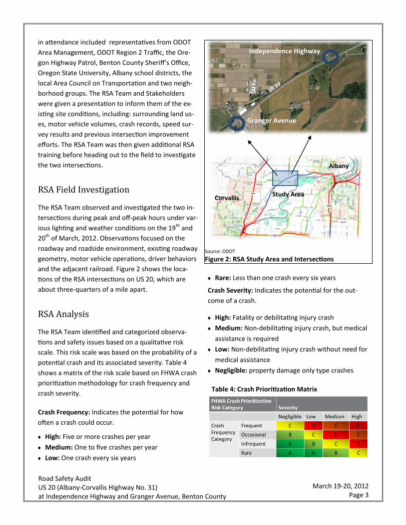
and the adjacent railroad. Figure 2 shows the loca-
tions of the RSA intersections on US 20, which are
about three-quarters of a mile apart.
RSA Analysis
The RSA Team identified and categorized observa-
tions and safety issues based on a qualitative risk
scale. This risk scale was based on the probability of a
potential crash and its associated severity. Table 4
shows a matrix of the risk scale based on FHWA crash
prioritization methodology for crash frequency and
crash severity.
Crash Frequency: Indicates the potential for how
often a crash could occur.
High: Five or more crashes per year
Medium: One to five crashes per year
Low: One crash every six years
Rare: Less than one crash every six years
Crash Severity: Indicates the potential for the out-
come of a crash.
High: Fatality or debilitating injury crash
Medium: Non-debilitating injury crash, but medical
assistance is required
Low: Non-debilitating injury crash without need for
medical assistance
Negligible: property damage only type crashes
Table 4: Crash Prioritization Matrix
Source: ODOT
Figure 2: RSA Study Area and Intersections
Granger Avenue
US 20
Independence Highway
Albany
Corvallis Study Area
Road Safety Audit US 20 (Albany-Corvallis Highway No. 31) at Independence Highway and Granger Avenue, Benton County
March 19-20, 2012 Page 4
This table assigns a letter score between A and F
based on the potential combinations of crash fre-
quency and crash severity. A score of “F” indicates
that there would be a high probability of frequent and
severe crashes - a poor situation that should be ad-
dressed with top priority. Conversely, a score of “A”
indicates that the probability of a crash would be rare
to infrequent and that the severity of the crash would
be negligible to low.
The RSA Team investigated options for improving
safety issues identified while in the field. These im-
provement options included potential enforcement,
education and engineering solutions. One of three
order of magnitude cost categories was assigned to
the suggested solution by the RSA Team. These cost
categories included:
Low: Maintenance staff assignments or low-cost
improvements
Medium: Minor to moderate new construction
High: Significant new construction.
RSA Presentation
Upon completion of the RSA field investigation on the
20th of March, the RSA Team compiled all of the ob-
servations and improvement options into a presenta-
tion for the RSA Stakeholders. This presentation had
been scheduled for the 21st of March, but it was can-
celed due to a snow storm event and was postponed
until the 5th of April. The RSA observations and sug-
gestions were generally well received by the RSA
Stakeholders in attendance for the presentation.
Stakeholder feedback at the presentation indicated
that many of the suggestions were consistent with
their ideas and expectations.
RSA Area Background
The RSA area background data investigated included
roadway characteristics, surrounding land use, motor
vehicle traffic volumes and crash history.
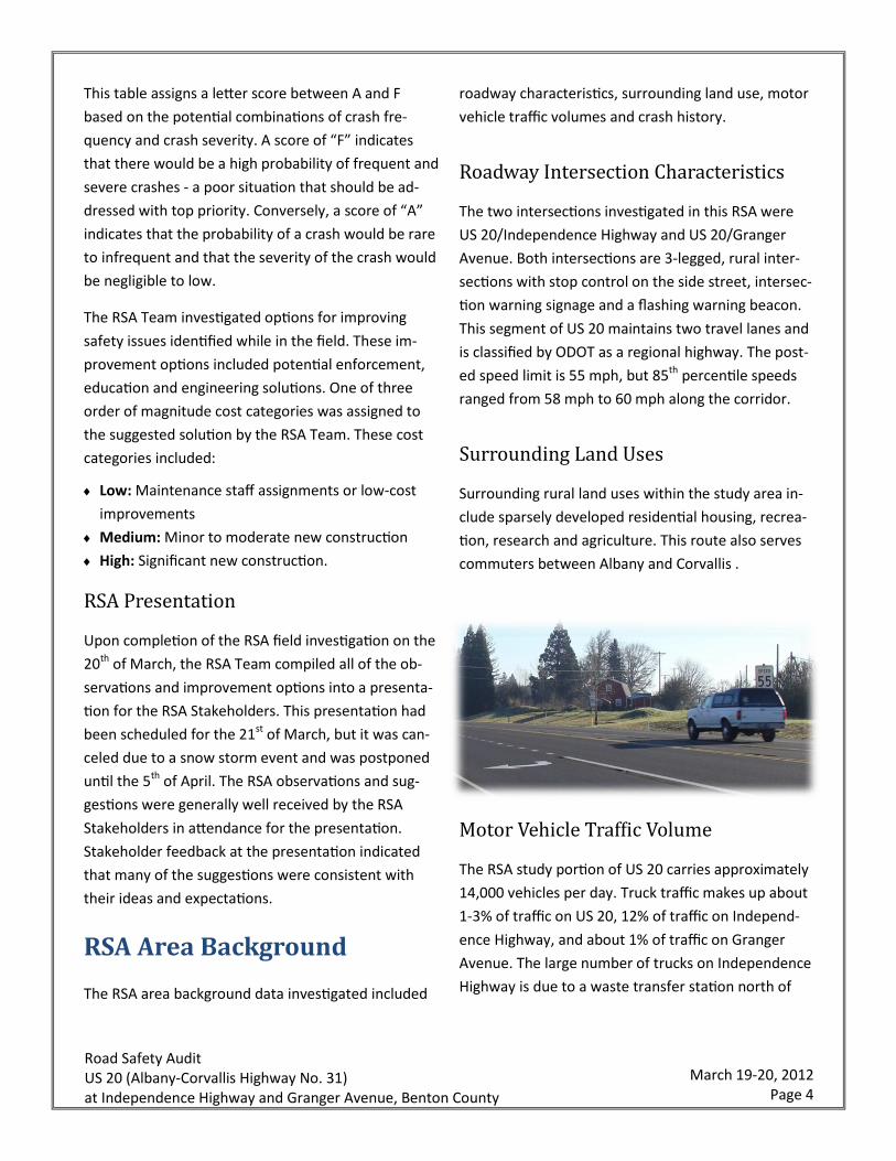
Roadway Intersection Characteristics
The two intersections investigated in this RSA were
US 20/Independence Highway and US 20/Granger
Avenue. Both intersections are 3-legged, rural inter-
sections with stop control on the side street, intersec-
tion warning signage and a flashing warning beacon.
This segment of US 20 maintains two travel lanes and
is classified by ODOT as a regional highway. The post-
ed speed limit is 55 mph, but 85th percentile speeds
ranged from 58 mph to 60 mph along the corridor.
Surrounding Land Uses
Surrounding rural land uses within the study area in-
clude sparsely developed residential housing, recrea-
tion, research and agriculture. This route also serves
commuters between Albany and Corvallis .
Motor Vehicle Traffic Volume
The RSA study portion of US 20 carries approximately
14,000 vehicles per day. Truck traffic makes up about
1-3% of traffic on US 20, 12% of traffic on Independ-
ence Highway, and about 1% of traffic on Granger
Avenue. The large number of trucks on Independence
Highway is due to a waste transfer station north of

Road Safety Audit US 20 (Albany-Corvallis Highway No. 31) at Independence Highway and Granger Avenue, Benton County
March 19-20, 2012 Page 5
Highway 20. Figure 3 shows the daily profile for east-
bound and westbound traffic on US 20 between Inde-
pendence Highway and Grander Avenue. This figure
shows the commuter nature of the area traffic with
distinct morning (7:00 to 8:00 a.m.) and evening (4:00
to 5:00 p.m.) peak hours. Traffic predominately
moves from Albany to Corvallis in the morning and
returns to Albany in the evening.
Crash History
Both intersections were top 5 percentile Safety Priori-
ty Index System (SPIS) sites in 2011, and have been
within the top 5 percentile or 10 percentile of
statewide SPIS sites since 2006. ODOT calculates SPIS
values on a yearly basis for state highway segments
based on an indexing formula to identify potentially
hazardous locations for further investigation. The SPIS
score is calculated using the most recent full three
years of available data and considers crash frequency,
crash rate and crash severity. Figure 4 shows the
statewide top 5 percentile and top 10 percentile val-
ues and the SPIS values for the US 20 intersections at
Independence Highway and at Granger Avenue.
Independence Highway
The five-year crash history (2006 to 2010) at the US
20/Independence Highway intersection included a
total of 23 Total Crashes with the following character-
istics:
Source: ODOT
Figure 4: SPIS History – Independence Highway and Granger Avenue
Source: ODOT
Figure 3: US 20 Mainline Volumes

Road Safety Audit US 20 (Albany-Corvallis Highway No. 31) at Independence Highway and Granger Avenue, Benton County
March 19-20, 2012 Page 6
2 Debilitating Injury Crashes (9%)
7 Property Damage Only (PDO) Crashes (30%)
20 Turning Movement Crashes (87%)
14 Occurred between 12:00 and 6:00 p.m. (61%)
18 Occurred during the daylight conditions (78%)
16 Occurred under dry conditions (70%)
The patterns of crashes indicate that high traffic vol-
ume and limited gap availability may be more of a
contributing factor than roadside hazards or environ-
mental factors. To better understand the crash
patterns, ODOT created crash diagrams using data
from 2004 to 2006 and from 2008 to 2010 (See Figure
5). Data from 2007 was excluded from the crash dia-
gram because a Statewide Transportation Improve-
ment Program safety project rebuilt the left and right
turn lanes to current standards in 2007 and added
new signage and flashing warning beacons.
The crash diagrams put together by ODOT revealed
that most every type of crash had been eliminated
after the 2007 improvements, with the exception of
the left turn crashes, which have since doubled.
US 20 at Independence Highway Facing East
2004 to 2006
15 Total Crashes
8 Left Turn Crashes
2008 to 2010
16 Total Crashes
15 Left Turn Crashes
Source: ODOT
Figure 5: Crash Diagram – Independence Highway

Road Safety Audit US 20 (Albany-Corvallis Highway No. 31) at Independence Highway and Granger Avenue, Benton County
March 19-20, 2012 Page 7
Granger Avenue
The five-year crash history (2006 to 2010) at the US
20/Granger Avenue intersection included a total of 41
Total Crashes with the following characteristics:
1 Debilitating Injury Crash (2%)
17 PDO Crashes (41%)
29 Turning Movement Crashes (71%)
25 Occurred between 12:00 and 6:00 p.m. (61%)
36 Occurred during the daylight conditions (88%)
29 Occurred under dry conditions (71%)
Similar to the patterns observed at Independence
Highway, these patterns of crashes indicate that high
traffic volume and limited gap availability may be
more of a contributing factor than roadside hazards
or environmental factors.
Figure 6 shows the crash diagrams created by ODOT
using data from 2004 to 2006 and from 2008 to 2010.
Data from 2007 was excluded from the crash diagram
because a Statewide Transportation Improvement
Program safety project rebuilt the left and right turn
lanes to current standards in 2007.
US 20 at Granger Avenue Facing East
2004 to 2006
8 Total Crashes
6 Left Turn Crashes
2008 to 2010
29 Total Crashes
21 Left Turn Crashes
Source: ODOT
Figure 6: Crash Diagram – Granger Avenue
Road Safety Audit US 20 (Albany-Corvallis Highway No. 31) at Independence Highway and Granger Avenue, Benton County
March 19-20, 2012 Page 8
As with the intersection at Independence Highway,
the crash diagrams put together by ODOT revealed
that left turning crashes more than tripled after the
improvements were installed in 2007. Unlike at Inde-
pendence Highway, other types of crashes increased
at Granger Avenue in addition to the left turning
crashes.
Road Safety Audit Team Findings Summary
The RSA Team made observations relating to the fol-
lowing categories:
Environmental Observations
Road User Observations
Driver Behavior Observations
Geometric Issues
Operational Issues
Railroad Issues
Enforcement Issues
Environmental Observations
The RSA Team observed the roadside and roadway
environments and determined that there were no
significant factors that could potentially contribute
the to increase in crashes at either location. The visu-
al fields were clear of trees and other visual clutter.
Street lights were not provided at either location, due
to the rural nature of the surrounding land uses. This
was not seen as an issue, since the majority of the
crashes occur during the day and the non-provision of
lighting fits within the surrounding environment.
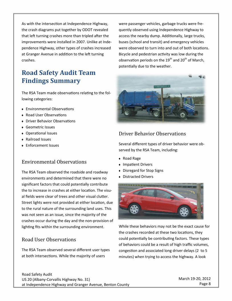
Road User Observations
The RSA Team observed several different user types
at both intersections. While the majority of users
were passenger vehicles, garbage trucks were fre-
quently observed using Independence Highway to
access the nearby dump. Additionally, large trucks,
buses (school and transit) and emergency vehicles
were observed to turn into and out of both locations.
Bicycle and pedestrian activity was low during the
observation periods on the 19th and 20th of March,
potentially due to the weather.
Driver Behavior Observations
Several different types of driver behavior were ob-
served by the RSA Team, including:
Road Rage
Impatient Drivers
Disregard for Stop Signs
Distracted Drivers
While these behaviors may not be the exact cause for
the crashes recorded at these two locations, they
could potentially be contributing factors. These types
of behaviors could be a result of high traffic volumes,
congestion and associated long driver delays (2 to 5
minutes) when trying to access the highway. A look

Road Safety Audit US 20 (Albany-Corvallis Highway No. 31) at Independence Highway and Granger Avenue, Benton County
March 19-20, 2012 Page 9
into the crash records revealed that the majority of
the crashes involved local drivers. None of the crash-
es documented alcohol or speeding as contributing
factors. The combination of the observations and the
recorded crash documentation hints at a correlation
between driver behavior and congestion as being
contributing factors to the crashes at both locations.
Geometric Issues
Four geometric issues were identified by the RSA
Team:
Narrow Shoulder Width at Independence Highway
Limited Storage Between Railroad and Highway on
Side Street
Right Turning Highway Vehicles Blocking View of
Side Street Traffic
No Pedestrian/Bicycle Facilities
Of the four issues listed above, the RSA Team believes
that the single greatest geometric issue associated
with the increase in left turn crashes at both locations
was the installation of the right turn lanes on US 20.
This is due to the fact that a high volume of vehicles
turning onto the side street block the view of oncom-
ing traffic for drivers waiting to enter US 20 from In-
dependence Highway or Granger Avenue.
Operational Issues
The core of operational issues observed by the RSA
Team was congestion-related. These issues included:
Large Platoons of Vehicles (30+) on US 20 Create
Infrequent Gaps for Side Street Traffic
Long Queues (10+ Vehicles ) and Delays (2 to 5
Minutes) for Side Street Traffic during Peak Hours
Long Train Delay (6 to 7 Minutes ) and Resulting
Queues (5 Vehicles from US 20 at Granger Avenue )
Local Traffic Diverts to North Albany Road and
Springhill Drive due to Congestion
High traffic volumes, few gaps and high side street
delay likely contribute to the impatient driver behav-
iors mentioned previously. Delay for the left turning
vehicles onto US 20 was observed to be much greater
than for the right turning vehicles, because the left
turning vehicles need to look for gaps in both direc-
tions of traffic. The majority of crashes at both loca-

Road Safety Audit US 20 (Albany-Corvallis Highway No. 31) at Independence Highway and Granger Avenue, Benton County
March 19-20, 2012 Page 10
tions were recorded to be collisions between left
turning movements onto US 20 and westbound
through movements.
Rail Issues
The RSA Team observed four rail related issues, in-
cluding:
Limited Storage between Highway and Railroad on
Independence Highway and Granger Road
Steep Approach Road Grades from US 20
Stop Bar for Railroad set back from Crossing Arm
Vehicles Stopping on Railroad Tracks
While there have not been any train/motor vehicle
crashes recorded since 2004, the potential for these
types of crashes does exist due to the issues listed
above. In particular, the frequently observed driver
behavior of stopping on or near the tracks (within the
area of the gates) could be a contributing factor for
future train/motor vehicle crashes.
Enforcement
During the observation period the RSA Team per-
ceived a lack of enforcement on US 20 at Independ-
ence Highway and at Granger Avenue due to the fre-
quency of drivers failing to stop at the stop sign be-
fore proceeding onto the highway. Additionally, the
practice of illegal left turns was of concern to the
team. Two types of illegal left turns were observed by
the project team. At the Independence Highway inter-
section, vehicles were observed to be using the solid
striped median as a staging area for making a two
stage left turn. At Granger Avenue, drivers were ob-
served to use the westbound left turn lane as an ac-
celeration lane to merge into traffic on US 20.
RSA Issue and Suggestion Prioritization
The full list of issues and improvement suggestions
has been included in the appendix to this document.
Since several of the suggested improvements would
cover one or more of the issues identified by the RSA
Team, several of the issues were combined. This al-
lowed for a simpler method to summarize the issues,
rank the suggestions and prioritize using the risk scale
identified previously. The RSA Team identified and
ranked the following six core issues:
Left Turn Crashes (Rank “F”)
Driver Behavior (Rank “D”)
Vehicles Queuing on Railroad Tracks (Rank “C”)
No Bicycle or Pedestrian Facilities (Rank “C”)
Railroad Grades and Markings (Rank “A”)
Narrow Shoulders (Rank “A”)

Road Safety Audit US 20 (Albany-Corvallis Highway No. 31) at Independence Highway and Granger Avenue, Benton County
March 19-20, 2012 Page 11
Issue #1: Left Turn Crashes
The left turn crashes at
both Independence
Highway and at Granger
Avenue were seen by
the RSA Team as being the highest priority issue. The
issue was ranked as having “High” potential frequen-
cy and severity, which gave it a rank of “F.” Potential
improvement suggestions and their associated costs
have been listed below in ascending order by cost.
Low Cost Suggestions
Convert (restripe) Median/Left Turn Lane to Con-
tinuous Left Turn Lane to Allow Refuge Zone for
Left Turning Vehicles
Add Buffer Between Right Turn and Through Lanes
to Improve Sight Distance for Left Turning Vehicles
entering US 20 from the Side Street
Medium Cost Suggestions
Construct a Median Acceleration Lane for Left
Turns onto US 20 from Granger Avenue
Intelligent Transportation System Solutions to
Warn Motorists on US 20 of the Presence of On-
coming Traffic from Independence Highway and
Granger Road
Restrict Turn Movements (Right In-Right Out Only)
and Provide Turn Around Points West of Granger
Avenue for Left Turning Traffic to Eliminate the
Left Turning Conflict
High Cost Suggestions
Install a Roundabout or Signal at Granger Avenue,
Close the US 20 intersection with Independence
Highway and Construction a three quarter mile
Frontage Road to Connect Granger Avenue and
Independence Highway
Install a Traffic Signal at Independence, Close the
US 20 Intersection at Granger Avenue and con-
struct a three quarter mile Frontage Road to Con-
nect Independence Highway to Granger Avenue
Issue #2: Driver
Behavior
Driver behaviors were
identified by the RSA
Team as a potential contributing factor in the crashes
recorded at both locations. Driver behaviors, such as
impatience, disregard for stop signs, distracted driv-
Severity Medium
Frequency Occasional
Rank D
US 20 at Granger Avenue Continuous Left Turn Lane
US 20
Independence Highway
US 20
Granger
Avenue Severity High
Frequency Frequent
Rank F
US 20 at Independence Highway Continuous Left Turn Lane
Road Safety Audit US 20 (Albany-Corvallis Highway No. 31) at Independence Highway and Granger Avenue, Benton County
March 19-20, 2012 Page 12
ing and road rage were observed for the left and
right turning vehicles entering US 20 from the side
streets. Because driver behavior was only one of sev-
eral factors contributing to crashes at the intersec-
tions, the potential severity was identified as
“Medium” and the frequency was “Occasional”,
which equated to a ranking of “D.” Improvement sug-
gestions related to driver behavior have been listed
below and sorted by costs.
Low Cost Suggestions
Increased Targeted Enforcement of Rolling Stops
and Distracted Driving
Construct Enforcement Pads near Intersections for
Police use
Provide Overtime Enforcement Funding
Medium Cost Suggestions
ITS Solution to Warn Motorists on Independence
Highway and Granger Road about Oncoming Traffic
on US 20
Construct a Median Acceleration Lane for Left
Turns onto US 20
Restrict Turn Movements (Right In-Right Out Only)
and Provide Turn Around Points West of Granger
Avenue for Left Turning Traffic to Eliminate the Left
Turning Conflict
High Cost Suggestions
Install a Roundabout or Signal at Granger Avenue,
Close the US 20 intersection with Independence
Highway and Construction a three quarter mile
Frontage Road to Connect Granger Avenue and
Independence Highway
Install a Traffic Signal at Independence, Close the
US 20 Intersection at Granger Avenue and con-
struct a three quarter mile Frontage Road to Con-
nect Independence Highway to Granger Avenue
Issue #3: Vehicles Queuing on Tracks
The queuing of vehicles
on the railroad tracks,
while being a subset of
driver behavior, was ob-
served frequently by the RSA Team and considered to
be an issue. The RSA Team ranked this issue “C,” since
potential severity of a train/motor vehicle crash
would be “High” but the frequency would be “Rare.”
Improvement suggestions and their associated costs
have been listed below and sorted by cost.
Low Cost Suggestion
Install MUTCD W10-11A Sign “XX
FEET BETWEEN TRACKS AND HIGH-
WAY” to Inform Drivers of the Limited
Storage
Medium Cost Suggestions
Construct Left and Right Turn Lanes for Side Street
Approach to Separate out the Left– and Right-
Turning Vehicles
Widen Shoulder on US 20 on provide a Refuge Area
for Vehicles that Can’t find a Gap to Enter US 20
during Train Events
ITS Active Warning Sign that Illuminates when Vehi-
cles stop on Tracks.
Severity High
Frequency Rare
Rank C
US 20 at Granger Avenue Acceleration Lane for Left Turns onto US 20
Granger
Avenue
US 20
Road Safety Audit US 20 (Albany-Corvallis Highway No. 31) at Independence Highway and Granger Avenue, Benton County
March 19-20, 2012 Page 13
High Cost Suggestion
Install a Traffic Signal with Railroad Interconnect
and Advanced Warning to Improve Side Street De-
lay and to Eliminate the Need for Vehicles to Queue
between the Railroad Track and the Highway
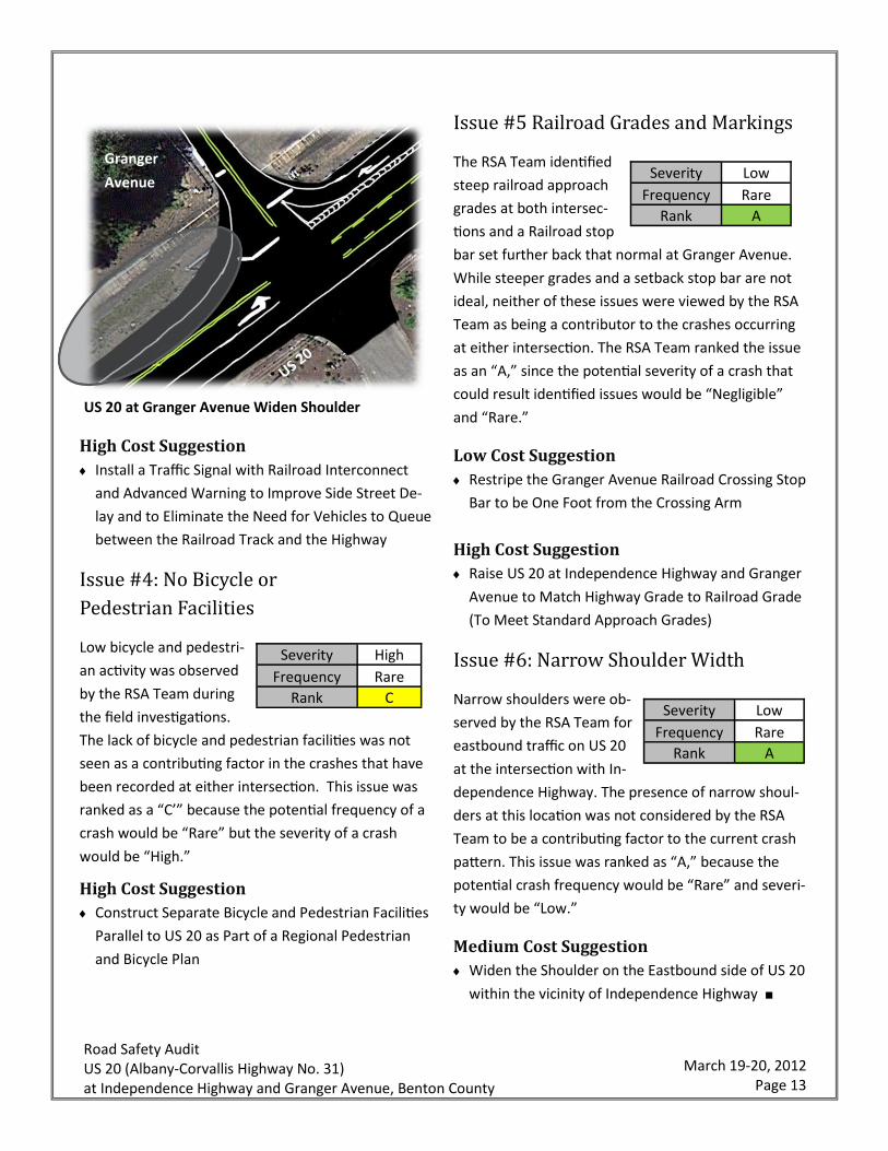
Issue #4: No Bicycle or
Pedestrian Facilities
Low bicycle and pedestri-
an activity was observed
by the RSA Team during
the field investigations.
The lack of bicycle and pedestrian facilities was not
seen as a contributing factor in the crashes that have
been recorded at either intersection. This issue was
ranked as a “C’” because the potential frequency of a
crash would be “Rare” but the severity of a crash
would be “High.”
High Cost Suggestion
Construct Separate Bicycle and Pedestrian Facilities
Parallel to US 20 as Part of a Regional Pedestrian
and Bicycle Plan
Issue #5 Railroad Grades and Markings
The RSA Team identified
steep railroad approach
grades at both intersec-
tions and a Railroad stop
bar set further back that normal at Granger Avenue.
While steeper grades and a setback stop bar are not
ideal, neither of these issues were viewed by the RSA
Team as being a contributor to the crashes occurring
at either intersection. The RSA Team ranked the issue
as an “A,” since the potential severity of a crash that
could result identified issues would be “Negligible”
and “Rare.”
Low Cost Suggestion
Restripe the Granger Avenue Railroad Crossing Stop
Bar to be One Foot from the Crossing Arm
High Cost Suggestion
Raise US 20 at Independence Highway and Granger
Avenue to Match Highway Grade to Railroad Grade
(To Meet Standard Approach Grades)
Issue #6: Narrow Shoulder Width
Narrow shoulders were ob-
served by the RSA Team for
eastbound traffic on US 20
at the intersection with In-
dependence Highway. The presence of narrow shoul-
ders at this location was not considered by the RSA
Team to be a contributing factor to the current crash
pattern. This issue was ranked as “A,” because the
potential crash frequency would be “Rare” and severi-
ty would be “Low.”
Medium Cost Suggestion
Widen the Shoulder on the Eastbound side of US 20
within the vicinity of Independence Highway ■
US 20 at Granger Avenue Widen Shoulder
Granger
Avenue
US 20
Severity Low
Frequency Rare
Rank A
Severity Low
Frequency Rare
Rank A
Severity High
Frequency Rare
Rank C