Embed Size (px)
Citation preview
East San Pedro Bay Ecosystem Restoration Study
Project Management Plan (PMP)
July 2010
UUSS AArrmmyy CCoorrppss ooff EEnnggiinneeeerrss LLooss AAnnggeelleess DDiissttrriicctt


PMP ACCEPTANCE SHEET Page 1 of 2
As members of the Los Angeles District Project Review Board, we the undersigned, concur with the contents of the Project Management Plan dated, May 2010, for the Long Beach Ecosystem Restoration Feasibility Study. We understand that the Project Management Plan is a living management document that will be updated throughout the course of the study.
Name/Title Signature Date
JOSEPHINE AXT, PH.D. Chief, Planning Division
BRIAN M. MOORE Chief, Programs & Project Management Division
KELLI JOHNSON Chief, Programs Management Branch
JOHN KEEVER Chief, Construction Division
RICHARD LEIFIELD Chief, Engineering Division
LAWRENCE N. MINCH Chief, Office of Counsel
DAVID CASTANON Chief, Regulatory Division
THERESA M. KAPLAN Chief, Asset Management Division

CONCURRENCE Page 2 of 2
As the responsible functional elements of the Los Angeles District, we the undersigned, concur with the contents of the the Project Management Plan dated, May 2010, for the Long Beach Ecosystem Restoration Feasibility Study. We understand that the Project Management Plan is a living management document that will be updated throughout the course of the study.
Name/Title Signature Date
EDUARDO DEMESA Chief, Plan Formulation Branch
JODI CLIFFORD Chief, Environmental Resources Branch
ARTHUR Y. JUNG Chief, Design Branch
MIKE HALLISY Chief, Economics Section
DAVID VAN DORPE Chief, Project Management
TERESA WILT Chief, Geology Section
JIM FARLEY Chief, Soils Section
DAN WHITE Chief, Real Estate Civil Works Branch

ii
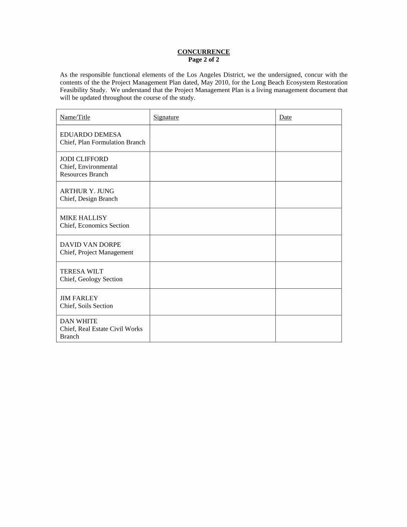
TABLE OF CONTENTS
Chapter I- Purpose and Scope I-1
Chapter II - Section 905(b) (WRDA) Analysis II-1
Chapter III - Work Breakdown Structure III-1
Chapter IV - Scopes of Work IV-1
Chapter V - Responsibility Assignment V-1
Chapter VI – Feasibility Study Schedule VI-1
Chapter VII - Feasibility Cost Estimate VII-1
Chapter VIII - Quality Management Plan VIII-1
Chapter IX - Identification of Procedures and Criteria IX-1
Chapter X - Coordination Mechanisms X-1
ENCLOSURES
Enclosure A - Project Area Map A-1
Enclosure B - CESPD Milestone System – Feasibility Phase B-1
Enclosure C - Detailed Scopes of Work C-1
Enclosure D - PMP Quality Certification D-1
Enclosure E - List of Acronyms E-1
I - 1
EAST SAN PEDRO BAY ECOSYSTEM RESTORATION STUDY
FEASIBILTY PHASE PROJECT MANAGEMENT PLAN
CHAPTER I – PURPOSE AND SCOPE 1. DEFINITION OF A PROJECT MANAGEMENT PLAN:
a. The project management plan for the feasibility phase, herein after referred to as the PMP, is an attachment to the Feasibility Cost Sharing Agreement (FCSA), which defines the planning approach, activities to be accomplished, schedule, and associated costs that the Federal Government and the local sponsor(s) will be supporting financially. The PMP, therefore defines a contract between the Corps and the local Sponsor(s), and reflects a "buy in" on the part of the financial backers, as well as those who will be performing, and reviewing, the activities involved in the feasibility study. The PMP describes the initial tasks of the feasibility phase, continues through the preparation of the final feasibility report, the project management plan for project implementation and design agreement, and concludes with support during the Washington-level review of the final feasibility report.
b. The PMP is a basis for change. Because planning is an iterative process without a predetermined outcome, more or less costs and time may be required to accomplish reformulation and evaluations of the alternatives. Changes in scope will occur as the technical picture unfolds. With clear descriptions of the scopes and assumptions outlined in the PMP, deviations are easier to identify. The impact in either time or money is easily assessed and decisions can be made on how to proceed. The PMP provides a basis for change.
c. The PMP is a basis for the review and evaluation of the feasibility report. Since the PMP represents a contract among study participants, it will be used as the basis to determine if the draft feasibility report has been developed in accordance with established procedures and previous agreements. The PMP reflects mutual agreements of the district, division, sponsor and HQUSACE into the scope, critical assumptions, methodologies, and level of detail for the studies that are to be conducted during the feasibility study. Review of the draft report will be to insure that the study has been developed consistent with these agreements. The objective is to provide early assurance that the project is developed in a way that can be supported by higher headquarters. d. The PMP is a study management tool. It includes scopes of work that are used for funds allocation by the project manager. It forms the basis for identifying commitments to the non-Federal sponsor and serves as a basis for performance measurement. 2. SUMMARY OF PROJECT MANAGEMENT PLAN CONTENTS:
This PMP is comprised of the following chapters:
Chapter 1 - Purpose and Scope. This chapter includes the definition of the PMP and a summary of the PMP requirements.
Chapter 2 - Section 905(b) Analysis. This chapter includes the approved Section 905(b)
Analysis that includes an overview of the reconnaissance study findings, the plan formulation rationale and proposed streamlining initiatives. This chapter also documents any deviations from the approved Section 905(b) Analysis that have occurred during the negotiations of the FCSA.
I - 2
Chapter 3 - Work Breakdown Structure. A product based Work Breakdown Structure (WBS)
defines the project, sub-projects, parent tasks and tasks that will be accomplished through the study.
Chapter 4 - Scopes of Work. A detailed scope of the tasks and activities that describe the
work to be accomplished, in narrative form, that answers the questions: "what, how, and how much". This chapter provides a reference to the detailed scopes of work that are included as Enclosure C to the PMP.
Chapter 5 - Responsibility Assignment. An Organizational Breakdown Structure (OBS) will
define "who" will perform work on the study. This allows the identification of the functional organization that will perform each of the tasks in a Responsibility Assignment Matrix (RAM).
Chapter 6 – Feasibility Study Schedule. The schedule will define "when" key decision points,
CESPD milestone conferences and mandatory HQUSACE milestones will be accomplished.
Chapter 7 - Feasibility Cost Estimate. This is the baseline estimate for the feasibility phase of the study.
Chapter 8 - Quality Management Plan: This chapter supplements the district’s Quality
Management Plan. It highlights any deviations to the district’s plan and lists the members of the study team and the independent review team.
Chapter 9 - Identification of Procedures and Criteria: This chapter identifies references to the
regulations and other guidance that covers the planning process and reporting procedures.
Chapter 10 - Coordination Mechanisms: This chapter describes the study’s public involvement program.
II - 1
CHAPTER II
SECTION 905(b) (WRDA 86) ANALYSIS
EAST SAN PEDRO BAY
ECOSYSTEM RESTORATION STUDY SECTION 905(b) (WRDA 86) ANALYSIS
1. STUDY AUTHORITY
1.1 AUTHORIZATION This Section 905(b) (WRDA) Analysis was prepared under the authority of the following Congressional Resolution, which reads as follows: Senate Resolution, approved 25 June 1969, reading in part:
“Resolved by the Committee on Public Works of the United States Senate, that the Board of Engineers for Rivers and Harbors, created under Section 3 of the River and Harbor Act, approved June 13, 1902, be, and is hereby requested to review the report of the Chief of Engineers on the Los Angeles and San Gabriel Rivers and Ballona Creek, California, published as House Document Numbered 838, Seventy-sixth Congress, and other pertinent reports, with a view to determining whether any modifications contained herein are advisable at the present time, in the resources in the Los Angeles County Drainage Area.”
1.2 APPROPRIATIONS
Funds in the amount of $90,000 were appropriated in fiscal year 2010 to initiate and complete the reconnaissance phase of what was known as the Long Beach Breakwater (East San Pedro Bay) Ecosystem Restoration Study. From here forward the study will be titled, East San Pedro Bay Ecosystem Restoration Study. Initial research and public outreach were conducted by the City of Long Beach beginning in 2008, external to the U.S. Army Corps of Engineers (USACE), with the hopes that much of that work would be applied to USACE standards for a 905(b) analysis. The City of Long Beach provided funds for the initiation of their own reconnaissance study in the amount of $100,000 through the City of Long Beach Tidelands Funding ($100,000) and reimbursed by a California State Coastal Conservancy grant ($50,000). 2. STUDY PURPOSE The purpose of the reconnaissance study is to determine if there is a Federal (USACE) interest in participating in a cost shared feasibility study to evaluate problems and opportunities for ecosystem restoration (restoration of habitat areas which historically
II - 2
existed in the region), water quality, and recreation improvements in East San Pedro Bay, Long Beach, California. The City of Long Beach initiated their own study in August 2008. The USACE initiated the reconnaissance study in February 2010. The 905(b) analysis has resulted in the finding that there is a Federal interest in continuing the study into the feasibility phase. The purpose of this Section 905(b) Analysis is to document the basis for this finding and establish the scope of the feasibility phase. As the document that establishes the scope of the feasibility study, the Section 905(b) Analysis is used as the chapter of the Project Management Plan (PMP) that presents the reconnaissance overview and formulation rationale. 3. LOCATION OF STUDY, NON-FEDERAL SPONSOR AND CONGRESSIONAL DISTRICTS
a. The study area is located offshore of the City of Long Beach, California in the easternmost part of San Pedro Bay. It includes the area between the Long Beach shoreline and the offshore Middle and Long Beach Breakwaters.
b. The non-Federal sponsor for the feasibility phase of the study is the City of Long Beach.
c. The study area lies within the jurisdiction of the following Congressional Districts: 1) The 37th District of U.S. Congresswoman Laura Richardson; 2) The 46th District of U.S. Congressman Dana Rohrabacher.
4. PRIOR REPORTS The following reports were reviewed as part of this study:
4.1 BREAKWATER AND SHORELINE AREA REPORTS
1. Coastal Erosion Issues Within the City of Long Beach – Draft Report – Prepared by City of Long Beach – June 1994
2. Comprehensive Condition Survey – Los Angeles-Long Beach Breakwaters – US Army Corps of Engineers – January 1985
3. East Beach Stabilization Project – Tetra Tech, Inc. – August 1991
4. East San Pedro Bay Ecosystem Restoration Study – Draft 905(b) Analysis –Prepared by City of Long Beach & Moffatt & Nichol Engineers – July 2009
5. Environmental Impact Concerns for Long Beach Harbor – CP “Bud” Johnson – February 2008
II - 3
6. Peninsula Beach Erosion – Draft Feasibility Study – US Army Corps of Engineers, LA District
7. Physical and Environmental Changes from the Proposed Removal of the Long Beach CA Breakwater: Implications for Sand Transport, Beach Profiles, Circulation and Water Quality – K. Morris – May 1998
8. Review of K. Morris Study by Coastal Frontiers – August 1999
9. Port of Long Beach – Pier J Breakwater – Beach Impacts Study – SeaDyn, Inc., July 1995
4.2 WATER AND SEDIMENT QUALITY DATA SOURCES
1. ABC Laboratories 2004. Los Angeles Contaminated Task Force Confined Aquatic Disposal Site Long Term Monitoring Program 2002 – 2003
2. RWQCB-LA Region and U.S. EPA – Region 9, 2008. Total Maximum Daily Loads for Toxic Pollutants in Dominguez Channel and Greater Los Angeles and Long Beach Harbor Waters, Draft: Water Quality Assessment, Problem Statement, Numeric Targets.
3. 2006 Final 303(d) List – Impairments for San Pedro Bay (includes area shoreward of LB Breakwater): Fish Tissue – DDT, PCBs. Sediment – Chlordane, PAHs, Cr, Cu, Zn, Toxicity. Fish consumption advisory for DDT and PCBs exists in San Pedro Bay and is supported by recent fish tissue results.
4. Kinnetic Laboratories, Inc. 2008. City of Long Beach, Recreational Water Quality Source Investigation, Open Coastal Beach Sites.
5. U.S. Army Corps of Engineers 2004.Los Angeles District. Los Angeles Regional Dredged Material Management Plan Feasibility Study.
6. U.S. Army Corps of Engineers, 2007. North Energy Island Borrow Pit CAD Site Pilot Study 2001-2006 Draft Monitoring Results
7. Weston 2006, Supplemental Sampling and Tier III and IV Analysis for LA River Estuary (LARE)
8. SCCWRP Bight 2003 Study – Water Quality
9. Blooms of Pseudo-nitzschia and Demoic Acid in the San Pedro Channel and Los Angeles Harbor Areas of the Southern California Bight, 2003-2004.
4.3 BIOLOGY DATA SOURCES
1. MEC 2002. Ports of Long Beach and Los Angeles Year 2000 Biological Baseline Study of San Pedro Bay. Prepared by MEC Analytical Systems Inc. for the Port of Long Beach Planning Division. June 2002.
II - 4
2. MBC 1984. Outer Long Beach Harbor – Queensway Bay Biological Baseline Survey. Prepared for the Port of Long Beach.
3. MBC 2003. Physical and Biological Monitoring at Golden Shore Marine Reserve, Long Beach, California Year 5 (2002). Final Report. Prepared for the City of Long Beach.
4. MBC 2006. Eelgrass, Caulerpa, and Giant Kelp Surveys, Prepared for Under Ocean Floor Seawater Intake/Discharge Demonstration Facility, in Long Beach Harbor offshore of Ocean Boulevard between Temple and Cherry Avenues.
5. MBC 2008. Status of the Kelp Beds, Ventura and Los Angeles Counties, Central Region Kelp Survey Consortium, 2007 Surveys.
6. SCCWRP Bight 2003 Study – Benthic Microfauna
7. SCCWRP Bight 2003 Studies - Demersal Fishes and Megabenthic Invertebrates
II - 5
4.4 EXISTING USACE PROJECTS/STUDIES RELATED TO THIS STUDY
1. Comprehensive Condition Survey – Los Angeles-Long Beach Breakwaters – January 1985. This study provides useful details of the breakwaters’ history, their construction and current condition.
2. Peninsula Beach Erosion – Draft Feasibility Study. This study provides data
regarding erosion of the Peninsula Beach area of Long Beach, which is adjacent to East San Pedro Bay.
3. Los Angeles River Ecosystem Restoration Study. This study is for a 32 mile
stretch of the LA River within the City of Los Angeles. The study area includes several locations where potential exists for restoring a more natural riverine environment, while maintaining and improving levels of flood protection. Treating effluent river flows by the use of treatment wetlands is also included.
4. Coyote Canyon- Lower San Gabriel Watershed. The study focuses on
watershed management, flood control, ecosystem restoration and water quality and supply solutions. The watershed encompass approximately 165 sq. miles, located 25 miles east of Los Angeles in Orange County and Los Angeles County, California. The area is a highly urbnaized residential, commercial and industrial development. The creeks vary between rectangular and trapezoidal concrete and riprap channels. This study is intended to result in a Decision Document for Congressional Authorization of specific projects.
4.5 OTHER EXISTING PROJECTS/STUDIES WHICH PROVIDE RELEVANT DATA TO THIS STUDY
Water Board Total Maximum Daily Loads (TMDLs) Project. Currently, there is an ongoing Water Board TMDL project to address pollutants in the Los Angeles River. Once implemented, the reduction of the pollutants discharged from the LA River will improve water quality conditions in the East San Pedro Bay. These TMDL improvements may supplement the improvements that could arise from the East San Pedro Bay Ecosystem Restoration Study. The TMDL is a number that represents the assimilative capacity of a receiving water to absorb a pollutant. The TMDL is the sum of the individual wasteload allocations for point sources, load allocations for nonpoint sources plus an allotment for natural background loading, and a margin of safety.
The following list identifies adopted TMDLs with their effective dates:
a. Los Angeles River Trash TMDL (Sept 19, 2001)
b. Los Angeles River Nitrogen TMDL (March 23, 2004)
c. Los Angeles River and Tributaries Metals TMDL (January 11, 2006)
d. TMDLs in Development
e. Los Angeles River Bacteria TMDL
II - 6
5. PLAN FORMULATION During a study, six planning steps that are set forth in the Water Resource Council’s Principles and Guidelines are repeated to focus the planning effort and eventually to select and recommend a plan for authorization. The six planning steps are: 1) specify problems and opportunities, 2) inventory and forecast conditions, 3) formulate alternative plans, 4) evaluate effects of alternative plans, 5) compare alternative plans, and 6) select recommended plan. The iterations of the planning steps typically differ in the emphasis that is placed on each of the steps. In the early iterations—those conducted during the reconnaissance phase—the step of specifying problems and opportunities is emphasized. That is not to say, however, that the other steps are ignored since the initial screening of preliminary plans that results from the other steps is very important to the scoping of the follow-on feasibility phase studies. The sub-paragraphs that follow present the results of the initial iterations of the planning steps that were conducted during the reconnaissance phase. This information will be refined in future iterations of the planning steps that will be accomplished during the feasibility phase. 5.1 NATIONAL OBJECTIVES 1. The national or Federal objective of water and related land resources planning is to contribute to national economic development consistent with protecting the nation’s environment, pursuant to national environmental statutes, applicable executive orders, and other Federal planning requirements. Contributions to National Economic Development (NED) are increases in the net value of the national output of goods and services, expressed in monetary units. Contributions to NED are the direct net benefits that accrue in the planning area and the rest of the nation. 2. The USACE has added a second national objective for National Ecosystem Restoration (NER) in response to legislation and administration policy. This objective is to contribute to the nation’s ecosystems through ecosystem restoration, with contributions measured by changes in the amounts and values of habitat. 3. There can also be a Federal interest in other related outputs of the alternatives, including recreational benefits. Recreation costs cannot increase the total federal cost by more than ten percent and any recreation features should be formulated to avoid impacts to the primary restoration purpose. If the recreation features comply with the above, the recreation benefits would not be constrained since they are not used in a benefit-to-cost analysis for the restoration. The National Ecosystem Restoration (NER) plan is identified based upon a CE/ICA analysis that ascertains the “best buy plans” of restoration only features. Recreation features must be separably economically justified.
II - 7
5.2 PUBLIC AND STAKEHOLDER CONCERNS Public input and outreach, conducted by the City of Long Beach, was critical to this reconnaissance study, given the proposed funding partnership between USACE and the City of Long Beach. A public introduction to the study and three public workshops were held over a two-month period in late 2008. The public outreach approach was structured not only to provide information and allow residents and other citizens the opportunity to provide statements of concerns and interests, but also to work in a hands-on fashion with the consultants and facilitators to develop specific visions incorporating their interests and concerns. Main examples of public concerns and goals from the workshops are summarized below.
1. Inputs from Public Workshops (not intended to be an exhaustive list, but representative of primary public inputs)
Inputs related to habitat
a. Restore bird / fish habitat
b. Reintroduce / improve marine life / habitat
c. Protect existing and develop new kelp habitat
d. Minimize or at least consider response to displacement of current animals and plants by removal
Inputs related to water quality
a. Decrease trash / debris on the beach
b. Train LA River away from shore to divert effluent from recreational areas, or through port area
c. Prevent LA River trash from reaching the open sea
d. Address cleaning pollutants from LA River
e. Press surrounding cities to clean up LA River front and remove debris from main entry points
f. Address public health issue associated with water quality
g. Address high rate of illness on boat workers
Inputs related to shoreline protection:
a. Protect homes
b. Control beach sand erosion
c. Restore natural beach re-sedimentation as much as possible
d. Reduce money spent to move sand from one end of beach to the other
Inputs related to recreation
a. Increase surfing opportunities
II - 8
b. Restore unimpeded natural wave height formation to increase aesthetic beauty to area and augment local economy (e.g. increase residential property values, local/tourist recreational use, downtown commercial value, parking revenue).
c. Maintain areas with favorable conditions for recreational sailing (low waves/high winds)
Inputs related to Long Beach Breakwater reconfiguration
a. Reuse breakwater material for new kinds of habitat (diving, fishing, birds, etc)
b. Use removed breakwater materials as artificial reef and protection of vulnerable oil islands, beaches, Belmont pier
c. Increase porosity of breakwater for selective wave passage
d. Shorten west end of breakwater to allow waves to wash out area of highest contamination
e. Remove the top of the breakwater to create a habitat and generate some wave action
f. Remove breakwater and build more oil and recreational islands/habitat edges in the harbor to slow down and disperse wave energy while still allowing the circulation and cleansing effect of the waves
g. Remove breakwater entirely, and build several smaller breakwaters instead
h. Create retractable or deployable breakwater to mitigate storm and high swells
i. Create access to expanded breakwater with new surf break and funding from real estate sales
j. Harness wave energy at gaps in breakwater system
Other miscellaneous inputs
a. Protect existing navigation ways and commercial use of the Port of Long Beach
b. Investigate Navy’s need for this specific ammunition loading area
c. Reduce the amount spent by the Long Beach Aquarium to import water for their tanks by improving water quality
d. Consider effects of rising sea level into simulations and calculations
In addition to the public workshops, meetings were conducted with individual stakeholder groups to solicit their input. Key constraints, as well as opportunities,
II - 9
were identified as part of this process. Some of the concerns and interests from each of the stakeholder groups are listed below (in alphabetical order).
2. Carnival Cruise Lines
a. Have experienced no downtime in their five years of operation
b. Support potential community benefit, but want no negative impact on operations
c. Potential for increased maintenance dredging resulting from increased wave action.
3. City of Long Beach – Marinas / Lifeguards
a. Trash on beach easier to pickup than trash in harbor
b. Breakwater provides critical recreational benefit – provides unique sailing environment – great wind and little wave action
c. Increased wave penetration – impact on docks/facilities
d. Impacts to navigation safety – cited the example of the Zuniga Jetty hazard at entrance to San Diego Bay
e. Concerned if the breakwater was lowered, that a gap could not be marked well enough, as vessels already hit the breakwater in its current condition
f. Impacts to fishing habitat
g. Impacts to bait barge operations
h. Increased surf and related activity may impact operations
i. Breakwater provides recreational benefit for swimming – small surf great for young kids
j. Belmont Pier dock and sport fishing operations 4. City of Seal Beach
a. Also have water quality issues
b. Impacts to sand transport and beach nourishment
c. Impacts to coastal flooding along East Beach
d. Impacts on disaster preparedness / tsunami 5. Peninsula Beach Preservation Group
a. Many of Long Beach peninsula residents opposed to breakwater modification
b. Concerned about protection of property along the shoreline (potential for property damage and long-term costs for sand replenishment)

II - 10
c. Concerned with the effects of rising sea level
d. Loss of “calm harbor” and resultant economic and recreational impacts
e. Pollutant “flushing” to open ocean (versus stopping pollutants at their source)
f. Loss of habitat along existing breakwater
II - 11
6. Port of Long Beach / Jacobsen Pilots / Operators (PMSA / SSA)
a. Impacts to existing habitat value
b. Increased wave penetration into commercial berths, especially during south swell:
1. Pier J
2. SE Basin
3. West Basin
4. Cost of tug operations if wave action increases – also fewer number of tugs available now to help keep ships in place at berth
5. Fatality to ship crew during surge
c. Increased wave activity at anchorages:
1. Transfer of personnel could become more difficult and unsafe
2. East anchorages get more use since can accommodate larger ships
d. Potential impact to “Port of Refuge” – safe harbor for damaged ship
e. Navigation hazard
f. Impact to City’s Confined Aquatic Disposal site 7. Surfrider Foundation
a. Want beach like Seal Beach, Huntington Beach, South Bay beaches – the difference is waves
b. Want to improve water quality and reduce trash and debris
c. Want to improve sediment quality along shoreline
d. Want to reduce breakwater height and plant kelp
e. Want economic benefit of cleaner beach 8. THUMS Oil Islands
a. Increased exposure to wave damage – cited significant damage in 1983 storms
b. Impacts to operations – travel from SE Basin to islands 24/7
c. Island White presently has surge problems during occasional wave events that impacts barge loading operations
d. Make sure consider any impacts to underwater pipelines to THUMS – water/oil/gas
II - 12
9. U.S. Coast Guard
a. Loss of safe anchorage capacity
b. Impact to lightering / bunkering operations
c. Impact to cruise ship operations
d. Navigation safety associated with any breakwater modifications
e. Potential impact to present security benefit provided by physical barrier
10. U.S. Navy – Naval Weapons Station (NWS)
a. Navy has an operational requirement to be able to load ammunitions inside the breakwater at least twice a year
b. Impacts to ammunition transfer at Explosives Anchorage if the sea states rise to an unacceptable level
c. Operations at Explosives Anchorage may increase in future due to increasing constraints with trucking of ammunitions
d. Impact of increased wave penetration into NWS berth
e. Impacts to dredging of NWS 11. USC Sea Grant Workshop (scientists and biologists familiar with San Pedro Bay)
a. Not a lot of existing reports and data for the area, with the exception of the Ports Biological Baseline Studies and existing City of Los Angeles monitoring sites near the mouth of the LA River.
b. The area is a “hotspot” for Harmful Algal Blooms (HABs), which are thought to be created by a combination of natural and non-natural inputs of nutrients and a circulation pattern which tends to retain the nutrients in the water column and allows the algal to bloom. These HABs are harmful to both marine life and humans.
c. The breakwater itself provides an important protected habitat used by several bird species for roosting and nesting and for several invertebrate species.
d. Perception that the LA River is probably not the only contributor to pollution in the Harbor. Other potential sources cited were the San Gabriel River and storm drains runoff.
e. SCE staff provided insight as to how to best create conditions for successful kelp establishment.
f. General consensus that increases to water clarity and reduction of nutrient load would improve conditions for marine habitat.
II - 13
5.3 VIEWS OF OTHER RESOURCE AGENCIES Because of the funding and time constraints of the reconnaissance phase, only limited and informal coordination has been conducted with other resource agencies. Discussions with the resources agencies were focused on identifying any additional study reports or information regarding the San Pedro Bay region, and general views regarding the need for ecological restoration. Agency views were also sought regarding the types of habitats that they would consider of particular value in a restoration effort. The persons contacted by the City of Long Beach, on an individual basis, are shown below:
Agency Contact
National Marine Fisheries Service (NMFS) Bryant Chesney
U. S. Fish and Wildlife Service (USFWS) Ken Corey
U. S. Environmental Protection Service (EPA) Peter Kozelka
California Department of Fish and Game (CDFG) Bill Paznokas, Loni Adams
Regional Water Quality Control Board, Los Angeles Region
Shirley Birosik, Michael Lyons, L.B. Nye
Most agency staff indicated that data for the East San Pedro Bay area was sparse but a few additional documents of relevance were obtained (in addition to those documents that had already been obtained). These included:
1. Recent kelp surveys that document the linear kelp beds associated with the breakwater and other riprap protects areas within San Pedro Bay,
2. A survey conducted for the City of Long Beach desalinization intake structure that identified the presence of eelgrass in nearshore waters fronting the beach at approximately Cherry Avenue, and
3. The draft toxics TMDL for the greater Los Angeles/Long Beach Harbor waters. Agency contacts generally recognized that the Harbor water is degraded, but also noted that information on habitat and water quality is limited in this portion of the Harbor and that additional survey work would be necessary to quantify the magnitude and extent of degradation. Concerns were expressed by NMFS and CDFG staff regarding the apparent frequency and impacts of red tides that appear to be associated with this region, although neither agency maintains historical records of red tides or fish kills in this area. Both agencies recognized that blooms are known to occur all along the coastline including areas without major input from urban rivers. As discussed previously, USC faculty stated that the area is a “hotspot” for Harmful Algal Blooms (HABs), which are harmful to both marine life and humans. The breakwater itself was noted to provide an important protected habitat used by several bird species for roosting and nesting and for several invertebrate species. This was considered a positive element of the current configuration that should be considered. Several people questioned whether the current protected waters within the breakwater
II - 14
provided for unique nursery and foraging habitat or if these waters would likely not differ from uses along open coastal areas of southern California. Most agencies expressed interest in restoration/improvement activities to increase rocky bottom and kelp habitat areas. Both types of habitats provide refuge and nursery habitat for important managed fisheries. 5.4 BASELINE CONDITIONS The study area (Attachment A) is located within East San Pedro Bay between the Long Beach Shoreline and the offshore Long Beach Breakwaters, east of the Port of Long Beach. To the west and northwest of San Pedro Bay are the communities of San Pedro and Wilmington, respectively and to the east the community of Seal Beach. The study area includes the waters in the immediate vicinity (and shoreward) of the breakwaters, the beaches of Long Beach spanning from the mouth of the Los Angeles River southward to the San Gabriel River, and the upstream reaches of the Los Angeles River that have direct impact on the Bay. A watershed perspective will be assessed in the study to identify how this effort may be integrated in a collaborative manner into larger watershed efforts being conducted by others. For example, coordination with other studies and efforts to target pollution and debris clean up further upstream of LA River. The study may consider the benefits of addressing ecosystem restoration measures within the LA River watershed. It is important to note that the boundaries of the study area as stated are preliminary and will be refined based on findings during the feasibility phase of the study. The Los Angeles and Long Beach harbors consist of about 1,800 acres of water in the inner navigation channels, 5,700 acres of landfill, and 6,000 acres of water (sheltered anchorages and navigation channels) between the landfills and the nine miles of Federally constructed and maintained breakwaters. This study would investigate two of the most prominent and contributing features within the Study Area, the Long Beach Breakwater and the Los Angeles River:
1) Long Beach Breakwater. San Pedro Bay is protected by three breakwater sections, totaling 8.6 miles in length, with two openings to allow ships to enter the Ports of Los Angeles and Long Beach. These openings divide the breakwater into three sections: the San Pedro Breakwater, the Middle Breakwater, and the Long Beach Breakwater. The San Pedro and Middle Breakwaters protect the Ports of Los Angeles and Long Beach, respectively. The 2.5 mile Long Beach Breakwater is the easternmost breakwater. The Long Beach Breakwater was authorized by Congress in 1940 as an extension to the San Pedro Bay Breakwater to provide a protected anchorage for the U.S. Navy’s Pacific Fleet. Construction of the breakwater by the federal government began in 1941 and was completed in 1949. As a federal project, the USACE maintains jurisdiction of the breakwater. The purpose of the ecosystem restoration study is to evaluate ecosystem restoration measures within East San Pedro Bay. In order to design a restoration project, reconfigurations of the Long Beach Breakwater, as it affects the water quality and hydrodynamics of the area, may be analyzed as part of an array alternatives. Potential reconfiguration could also provide an opportunity for rocky materials
II - 15
from the breakwater reconfiguration to be used for ecosystem restoration measures. 2) Los Angeles River. The Los Angeles River (LAR) is a major flood control waterway for the Los Angeles watershed basin. In the 1930s, USACE began channelizing the river for flood control and by 1954, the entire length of the river was channelized. The river is now operated and maintained by the USACE and the LA County Department of Public Works. The LA River discharges into San Pedro Bay. Alternatives for this ecosystem restoration project may look at changes needed within the LAR, as it negatively impacts the overall health of the bay.
In addition to the Breakwater and the River, the study area contains several locations in which there is potential for ecosystem restoration and recreational opportunities. The entire study area will be analyzed for ecosystem restoration opportunities.. The entire study area will be analyzed for ecosystem restoration opportunities. 5.4.1 BIOLOGICAL RESOURCES Prior to urbanization and port development (circa 1870), the Los Angeles and San Gabriel Rivers commingled in a large estuary at San Pedro Bay - approximately 3,450 acres of slough, mudflats, and salt marsh. By the 1930's, harbor-oriented channelization and landfill projects had largely reshaped the lagoon into the Los Angeles and Long Beach Harbors. The estuary underwent extensive industrial, commercial, and residential development, and its ecological diversity decreased. This led to a change of the historic estuarine habitat into mainly deepwater habitat, particularly due to development at the ports. The ecological importance of the estuary has significantly increased over time, however, due to the scarcity of estuarine resources in the southern California bight. First ecological studies of the Los Angeles and Long Beach Harbors began in the 1950s. These studies revealed the marine environment was severely polluted (Reish 1959). Dissolved oxygen was at one time depleted from the harbor waters and resulted in the elimination of the macro fauna (USFWS 1989). However, the benthic fauna has substantially improved since 1970 when national and state regulations were implemented to improve biota diversity and water quality. Presently, marine habitat in San Pedro Bay includes natural open water and sandy-bottom benthic habitats, as well as artificial habitats created by harbor structures. Organisms living in or on the sandy-bottom provide a food source for fish, invertebrates, and other organisms. Species richness is often lower in sandy-bottom habitats compared to other vegetated habitats. A large portion of East San Pedro Bay is characterized as sandy-bottom. The subtidal zone (i.e., always covered with water) along the Long Beach shoreline is also characterized as sandy or soft bottom. Eelgrass, a type of submerged aquatic vegetation, was detected in the vicinity of Cherry Beach in 2009. Areas with eelgrass are high in productivity and are important to fish and other organisms as a direct or indirect source of food. Despite the presence of eelgrass, the soft bottom subtidal zone
II - 16
along the Long Beach shoreline is degraded with significant amounts of trash lying on the bottom and embedded in the sand. Hard bottom or substrate habitats are of important ecological value as they provide food, shelter, and spawning and nursery areas to a wide variety of fish and shellfish species, and many other organisms. Hard substrates provide surfaces for the attachment of invertebrates and algae. Hard substrate habitats in San Pedro Bay are limited and include the breakwaters and jetties within the harbor complex as well as at pilings that support wharves and piers, and along the shoreline of the basins and channels. Additionally, the shore protection around the three oil islands within East San Pedro Bay provide hard substrate habitat. Hard bottom or substrate habitats support algal growth typical of rocky subtidal and intertidal communities. Breakwaters and jetties characteristically are populated by green algae (Ulva sp. and Enteromorpha sp.), and several species of red algae, and kelp (giant kelp (Macrocystis pyrifera) and feather boa kelp (Egregia menziesii)). Extensive kelp beds with fully formed kelp canopies create kelp forests that are highly productive habitats. Kelp forests provide habitat to a large variety of species, including invertebrates, fishes, birds, and mammals. Historically, extensive kelp beds were known to occur in the San Pedro Bay area, near Point Firmin (e.g. Horseshoe Kelp). The Horseshoe Kelp bed was reported to be two miles long and one-quarter to one-half mile wide (equates to 320 to 640 acres) and in water depths of 80 to 90 feet. This kelp bed disappeared in the 1920s to 1930s. The lack of kelp recovery at Horseshoe Kelp is not fully understood, however, it may be attributable to poor circulation or water quality (pers. comm.. Chesney 2010). Open water or pelagic habitats are areas in the water column of the open ocean. Organisms associated with this habitat occur within the water column, above the seafloor and below the surface. The open ocean habitat sustains a relatively large number of species of fish, marine mammals, turtles, and invertebrates that use this area for spawning, breeding, feeding, or growth to maturity. Open water or pelagic habitats exist throughout San Pedro Bay. The migratory bird community is dominated by coastal water birds, shorebirds, and waterfowl. Migratory birds use San Pedro Bay during annual migrations and for overwintering. Some have also become year-round residents. The diverse bird community is made up of about 150 species. The inner harbor is a major resting area for water birds. Feeding and roosting are two principal activities in the project vicinity. Birds using sheltered waters within the harbor for feeding and resting include loons, grebes, surf scooters, and lesser scaup. The sheltered waters offer mollusks and fish that are preyed upon by these species. Rip-rap shoreline is preferred by spotted sandpipers, surfbirds, willets, and pelagic cormorants. The small intertidal mudflat at Shoreline Aquatic Park (adjacent to the Los Angeles River estuary) is important foraging habitat for western sandpipers, semi-palmated plovers, and marbled godwits. This habitat is also used extensively by mew, ring-billed, and California gulls as a resting area. Buoys, barges,
II - 17
and pilings are primary roosting sites for double-crested cormorants, gulls, and brown pelicans. A number of special status species occur within the study area. They include the California least tern (Sternula antillarum browni), western snowy plover (Charadrius alexandrinus nivosus), Peregrine falcon (Falco peregrinus anatum), Belding’s savannah sparrow (Passerculus sandwichensis beldingi), black skimmer (Rynchops niger), common loon (Gavia immer), loggerhead shrike (Lanius ludovicianus), and the burrowing owl (Athene cunicularia). 5.4.2 WATER RESOURCES Water resources in the study area include Los Angeles and Long Beach Harbors, the Los Angeles and San Gabriel Rivers, and the Pacific Ocean. Because of past dredging and filling, construction of breakwaters and other structures, plus intensive use of the area, the chemical character of constituent waters has been significantly altered. River flows have also been greatly altered by flood control projects. Water quality in San Pedro Bay is affected by factors such as climate, water circulation, biological activity, surface runoff, effluent discharges and accidental discharges of pollutants from shipping activities as well as water flushed from the harbor and vessel activity. Studies during the 1950s revealed poor water quality conditions in the bay, particularly at the harbors. Circulation patterns were altered as breakwaters, channels, slips and basins were constructed. In the mid-1950s, restricted water circulation caused anoxic conditions at some of the slips and basins. Significant amounts of wastes were emptied into the waters, which also contributed to depletion of dissolved oxygen (DO) concentrations. However, water quality conditions have changed significantly since the 1970s as national and state regulations were implemented to improve biota diversity and water quality. Although water quality in the bay has improved over the past several decades, it remains degraded as industrial effluents and untreated run-off from storm drains and the surrounding area continue to be discharged into San Pedro Bay. These sources of contamination result in elevated levels of trace metals and organic chemicals in some areas, as well as elevated levels of bacteria (total coliforms, fecal coliforms, and Enterococcus). Additionally, trash and debris from the Los Angeles River continue to be a major problem within the bay, and along the Long Beach shoreline. Beach closures and water advisories occur often in Long Beach. 5.4.3 RECREATION Aside from the port operations, recreation activities account for most of the land and water uses in the general area. Recreation uses encompass onshore and near shore activities. Onshore recreation resources include beaches, parks, recreation facilities, and other visitor-serving attractions such as the Queen Mary. Shoreline Village, aquariums, fishing areas, hotels, and restaurants are located along Queen's Way Bay (the mouth of
II - 18
the Los Angeles River Estuary). Recreation opportunities involve passive activities such as sightseeing, sunbathing, and picnicking. Active uses include bicycling, sailing, swimming, shoreline and pier fishing. Shoreline and near shore uses that depend on land-based operations include such activities as sport fishing, commercial cruises, tour boats, boating, and sailing. Within the Los Angeles and Long Beach Harbor complex, several major charter boat companies provide charter service to Avalon and Isthmus Cove on Santa Catalina Island. These recreation charters also serve specialized activities, including sport fishing, scuba diving, whale watching, and harbor touring. The City of Long Beach contends that recreational opportunities are severely degraded when compared to other beach communities due to a lack of surf, large amounts of trash and debris on the beaches, and poor water quality. Commercial fishing within the bay is limited to a live-bait fishery, while a variety of commercial fisheries occur outside the harbors. Trap fisheries extend offshore from just outside the harbor breakwaters, while set and drift nets are restricted to beyond 3 miles from shore. Trawling occurs in deeper offshore waters. Primary target species from the various fishing operations include anchovies, squid, California halibut, rockfish, crab, and lobster. 5.5 PROBLEMS AND OPPORTUNITIES The evaluation of public concerns often reflects a range of needs, which are perceived by the public. This section describes these needs in the context of problems and opportunities that can be addressed through water and related land resource management. For each problem and opportunity, the existing conditions and the expected future conditions are described below. There are two basic categories of problems and opportunities. One category is for the problems and opportunities associated with Ecosystem Restoration and the other is for the problems and opportunities associated with Recreation (i.e. swimming, surfing and other beach-related activities). Ecosystem problems have been identified by both USACE and by the local sponsor, with the latter supported by the inputs from the stakeholder groups and literature review. 5.5.1 ECOSYSTEM PROBLEMS
1. Lack of rocky reef / hard bottom habitat. Rocky reef and other hard bottom habitat are considered to provide valuable habitat for economically important fish and macroinvertebrates. Current hard bottom habitat is limited to linear features of the breakwater and riprap protecting the THUMS oil islands and Port facilities. An artificial reef (mitigation as part of the Montrose settlement) is planned to be established west of Belmont Pier. Historically, rocky reef areas existed in San Pedro Bay prior to development of the Ports / Harbors.
2. Lack of kelp habitat. Both kelp and high relief, hard bottom habitats are considered to be important habitat for various rockfish species, ling cod, kelp and sand bass, as well as a variety of invertebrates. Kelp habitat within San Pedro
II - 19
Bay is limited to linear features associated with the breakwater and other rock structures. Historically, it is known that there have been extensive kelp beds in the San Pedro Bay area, e.g. Horseshoe Kelp. The Horseshoe Kelp Bed was reported to be two miles long and one-quarter to one-half mile wide (equates to 320 to 640 acres) and in water depths of 80 to 90 feet. This kelp bed completely disappeared in the 1920s to 1930s.
3. Other habitats. The soft bottom subtidal zone along the Long Beach shoreline is degraded with significant amounts of trash lying on and embedded within the bottom. Eelgrass beds, considered to be high in productivity and important to fish and other organisms, is limited in coverage and density along the Long Beach shoreline.
4. Reduced transmissivity (clarity) of the harbor waters. Transmissivity of the harbor waters is impacted during storm events as a result of discharges from the Los Angeles River or in association with Harmful Algal Blooms. Poor circulation within the breakwater contributes to persistence of turbid water in San Pedro Bay.
5. Impacted harbor water circulation. As part of the City’s study, water quality monitoring was conducted in 2008 in this region during dry weather conditions provides evidence that the plume from the Los Angeles River Estuary frequently impacts the western portion of the beach from Shoreline Harbor to Belmont Pier. Monitoring conducted subsequent to an early season storm event provided further evidence of poor flushing in this segment of the Bay. Decaying duckweed that had been discharged from the River during this event remained suspended in the nearshore waters for over a week. Recent three-dimensional modeling developed for the Port’s Water Resources Action Plan (WRAP) and two dimensional-modeling of tracer particles from the Los Angeles River conducted as part of this reconnaissance study provide further corroboration of the poor circulation.
6. Contaminants in the sediment (metals, pesticides, bacteria). Concentrations of metals and pesticides in sediments have been shown to be highest at sites within the Los Angeles River Estuary. Limited spatial data suggests that concentrations decline substantially with distance from the mouth of the estuary. Bacteria in the sand along the shoreline are also potentially problematic.
7. Contaminants in the water column (metals, nutrients). Water quality monitoring conducted to monitor conditions during placement of sediment at the North Energy Island Borrow Pit Confined Aquatic Disposal (CAD) site indicated that background concentrations of metals were elevated above California Ocean Plan criteria. Nutrient concentration in the Los Angeles River are often highly elevated during early season storm events, but also can be elevated in association with dry weather discharges. Elevated nutrient concentrations from the Los Angeles and San Gabriel Rivers may contribute to HABs that appear to be more frequent and intense in San Pedro Bay.
8. Trash/floating debris. Trash and floating debris from the Los Angeles River are considered to be a major problem in this region. Due to the prevailing winds, trash and floating debris are ultimately deposited on the beaches. The largest
II - 20
quantities of trash and debris wash up on the western end of the City beaches, but significant quantities are also collected at the far eastern end, adjacent to the Alamitos Bay jetty. Aside from aesthetic issues, organic matter associated with these materials harbor bacteria and evidence suggests that bacteria regrowth may occur in the wrackline along the beach.
5.5.2. RECREATION PROBLEMS The problems associated with the existing recreational uses are characterized by those problems associated with water quality and those associated with wave height / wave activity.
1. Impaired swimming / water recreation due to elevated bacteria levels and
trash/debris in the water and along the shoreline. Fecal indicator bacteria are commonly elevated in dry weather discharges from the Los Angeles River. Periodic sewage spills also contribute to elevated bacteria levels in the River. An average of 4,000 tons of trash and debris is deposited on City beaches annually. The prevailing winds out of the southwest tend to transport the brackish water surface plume towards the western end of the ocean beaches between Shoreline Marina and the Belmont Pier. During periods when the winds shift to a more southerly pattern, the plume is quickly transported to the beach face with limited additional dilution. Bacterial water quality criteria for full body contact are exceeded when such conditions are concurrent with elevated fecal indicator bacteria in the River.
2. Lack of wave activity for recreational activities. Wave heights along the Long Beach shoreline are currently not suitable for some recreational activities such as surfing. In contrast, nearby beaches such as Seal Beach and Huntington Beach have larger waves and are popular areas. Many long-time residents of Long Beach have noted that prior to the existence of the Long Beach Breakwater, the area was popular for surfing. In addition to the primary recreational objective of improving swimming conditions, local surfing groups (e.g. Surfrider Foundation) would like to restore the surfing conditions that Long Beach once had.
It is assumed that the existing conditions would remain unchanged and possibly would become worse over time if no project is implemented. 5.5.3. ECOSYSTEM AND RECREATION OPPORTUNITIES
Opportunities were identified by the public, stakeholder groups, and resource agencies. In general, the opportunities to address the existing ecosystem and recreation problems are as follows:
1. Restoration of degraded ecosystem in the study area (i.e. Rocky reef/hard bottom,
nearshore/softbottom). Rock could be used to create new rocky reef and kelp habitat areas. Coupled with the improved water quality, this is expected to create viable rocky reef / hard bottom and kelp habitat conditions within East San Pedro Bay. In addition, restoring high and low relief rocky reef habitat would increase nursery habitat and refuge for rock fish.
II - 21
2. Eliminate or reduce discharges of pollutants from the Los Angeles River into the East San Pedro Bay area. This is expected to improve water quality for both ecosystem and recreational benefits.
3. Increase tidal circulation and wave-induced mixing of the harbor waters. This increased circulation and mixing is expected to improve water quality and clarity, which would lead to an improved ecosystem, improve conditions to restrain/preclude Harmful Algal Blooms (HABs) formation, as well as improved recreational swimming conditions.
4. Increase wave height along the shoreline, while still providing adequate shore protection. This increased wave height is expected to help improve water quality, while also potentially creating recreational surfing and other wave activities conditions along certain sections of the shoreline.
The opportunities identified by both USACE and the sponsor were used as the basis of the measures/alternatives developed for the reconnaissance study and discussed further below. 5.6 PLANNING OBJECTIVES The national objectives of National Economic Development (NED) and National Ecosystem Restoration (NER) are general statements and not specific enough for direct use in plan formulation. The water and related land resource problems and opportunities identified in this study are stated as specific planning objectives to provide focus for the formulation of alternatives. These planning objectives reflect the problems and opportunities and represent desired positive changes in the without project conditions. The planning objectives are specified as follows:
1. To restore marine and aquatic habitat of sufficient quality to sustain or enhance marine and aquatic communities, e.g. kelp beds, shallow rocky reef areas and other habitats;
2. To restore and preserve the marine and aquatic ecosystems by improving
impaired sediments and water quality in East San Pedro Bay; 3. To increase recreational opportunities (surfing, swimming, beach use, tourism,
etc.) in East San Pedro Bay and its immediate surrounding beaches and beach communities.
5.7 PLANNING CONSTRAINTS AND CONSIDERATIONS Unlike planning objectives that represent desired positive changes, planning constraints represent restrictions that should not be violated. The planning constraints identified in this study are discussed below.
II - 22
1. The Long Beach Breakwater is outside of the City’s Local Coastal Program / land use plans, i.e. the breakwater is in federal waters. However, the breakwater definitely affects land and water use in its wave shadow. These uses are as follows and are considered to be constraints for all alternatives:
a. Bird and fish habitat. Endangered/threatened/sensitive species must not be
adversely affected. In addition, consideration must be given to the existing habitat uses of the breakwaters and the potential to impact/displace these habitats.
b. Shoreline structures and beaches. Existing residences, public infrastructure, marinas, other structures and recreational beaches must be protected from increases in erosion, wave related damages, and coastal flooding.
c. Port of Long Beach. Commercial berths must be protected from unacceptable
increases in wave penetration. In addition, anchorages and the “port of refuge” area (safe harbor for damaged ships) must be protected from excessive wave activity.
d. U.S. Navy explosives anchorage. This anchorage is located leeward of the
Long Beach Breakwater and is used by U.S. Navy ships to transfer explosives and/or sensitive electronics equipment. This capability must be retained.
e. THUMS Oil Islands. The existing shore protection around these oil islands
was based on wave conditions with the existing breakwater configuration. These islands will continue to require protection from storm wave’s penetration.
f. Confined Aquatic Disposal (CAD) site. A CAD site, for contaminated
sediments disposal, exists leeward of the Long Beach Breakwater, near the mouth of the LA River. The CAD site cap stability must be preserved.
g. Navigational safety. Safe navigation must be maintained for all vessels
entering and exiting the area.
h. Recreation. There are also concerns regarding impacts to existing recreational uses of the area leeward of the breakwater (e.g. recreational sailing). The calmer waters leeward of the breakwater provide a unique open ocean condition for recreational sailors.
2. Sea Level Rise. The potential impacts of future sea level rise must be considered for all
alternatives, including increased wave overtopping, erosion, and shoreline retreat.
3. Environmental Resource and Agency Constraints: Applicable environmental requirements must be met for a feasibility level study. Environmental acceptability must be ascertained; adverse impacts should be avoided if possible or minimized, if avoidance is not possible..
II - 23
5.8 MEASURES TO ADDRESS IDENTIFIED PLANNING OBJECTIVES A management measure is a feature or activity at a site, which address one or more of the planning objectives. An array of alternatives will be analyzed as part of the feasibility study. The alternatives may comprise of structural, nonstructural, or a combination of structural and nonstructural measures. A wide variety of measures were considered in the Long Beach preliminary study, some of which were found to be infeasible due to technical, economic, or environmental constraints (discussed in section 5.6). The descriptions and results of the evaluations of the measures considered in this study are presented below.
1. Non-Structural Non-structural measures have not been identified as part of the preliminary analysis; however nonstructural measures will be analyzed and considered during the feasibility study.
2. Structural Structural measures will be developed and analyzed during the
Feasibility Phase to meet the study objectives. Any structural alternatives would be formulated to satisfy restoration of the degraded ecosystems.
The following structural measures have been identified: a. Reconfiguration of the Long Beach Breakwater, b. Restoration of kelp and/or rocky reef habitat areas (either by importing new
rock or using rock available from breakwater reconfiguration), and c. Construction of a training structure and other changes to address specifically
the Los Angeles River pollutant discharges. 5.9 PRELIMINARY ALTERNATIVES Preliminary alternatives are comprised of one or more management measures that passed the initial screening conducted by the City of Long Beach, (i.e. the evaluations discussed above). The descriptions and results of the evaluations of the preliminary measures/alternatives that were considered in this study are summarized below:
1. No Action. USACE is required to consider the option of “No Action” as one of the alternatives in order to comply with the requirements of the National Environmental Policy Act (NEPA). No Action assumes that no project would be implemented by the Federal Government or by local interests to achieve the planning objectives. No Action, which is synonymous with the Without Project Condition, forms the basis from which all other alternative plans are measure.
2. Construct the rocky reef and/or kelp reef feature to restore impacted/lost ecosystem habitat. These areas could be created from either imported rock or from removed breakwater sections. The latter (breakwater reconfiguration) could provide rock to create on the order of 500 acres of kelp bed (the size of the historic Horseshoe Kelp Bed) and 50 acres of high and low relief rocky reef areas. This is proposed for further consideration based on direct replacement of lost
II - 24
habitat in San Pedro Bay. This is considered to be technically feasible, although navigational constraints would need to be addressed.
3. Reconfigure the LB Breakwater and construct the rocky reef and/or kelp reef feature(s). This alternative is proposed for further consideration based on the potential water quality improvements suggested by the hydrodynamics modeling and the potential ecosystem restoration benefits. Alternatives are considered to be technically feasible, although navigational, wave impacts, and shoreline erosion constraints would need to be addressed. Secondary measures carried forward with the breakwater configuration may include construction of new breakwater sections, groins, nearshore reef breakwaters, and beach nourishment.
4. Changes to Los Angeles River. Change alignment of LA River discharge. Water quality may be improved by constructing a shore-perpendicular rock “training” structure to redirect the LA River discharge away from the Long Beach shoreline. Rock from removed breakwater section(s) could be used for this construction, or rock could be imported from off-site sources. The new structure could also provide additional shore protection to the downtown marina and would provide new rocky habitat area. This alternative may include measures to address pollutants in LA River.
5.10 CONCLUSIONS FROM THE PRELIMINARY SCREENING The preliminary screening suggests that alternatives that address opportunities to both restore the marine ecosystem and enhance recreation, while accommodating constraints, have the greatest potential for implementation. Restoration of the reef and kelp habitat within San Pedro Bay can be enhanced by improving the water quality, clarity, and circulation. A means to accomplish this could be a reconfiguration of the Long Beach Breakwater, which has the added benefit of providing an in-water, local source for reef creation material. The potential magnitude and types of benefits from the proposed actions were evaluated based on: a) hydrodynamic and water quality modeling results, b) discussions with resource agency staff and knowledgeable individuals, and c) literature review. Ecosystem benefits associated with the proposed measures would include: a) re-establishment of kelp beds which once existed in the region (potentially 500+ acres, the size of the historic Horseshoe Kelp Bed); b) construction of high and low relief rocky reef areas (potentially 50+ acres) for fish refuge and invertebrates habitat; c) reduction of occurrence of harmful algal blooms; and d) increased water clarity to improve conditions for kelp, eelgrass and other habitats. The former two benefits are to restore historic ecosystems, which once existed in the San Pedro Bay region. Both kelp and rocky reef / hard bottom habitats are considered to be important habitat for various rockfish species, ling cod, kelp and sand bass, as well as a variety of invertebrates (e.g. lobster). The potential environmental impacts would be the loss of rocky habitat from the removal of breakwater section(s). This would be mitigated for by the creation of new rocky reef
II - 25
and kelp habitat areas elsewhere in the region using rock from the removed breakwater section(s). As discussed previously, preliminary hydrodynamic/water quality modeling results suggest breakwater reconfiguration could improve existing conditions relative to wave height and pollutant concentration. Both wave height and pollutant concentration are proxies of water quality. Improvements to water quality in turn would lead to improved ecosystem and recreational swimming conditions. In addition, increased wave height would improve conditions for wave activities (such as surfing and body-surfing). Therefore, the hydrodynamics modeling results suggest potential benefits to ecosystem restoration and recreational enhancements.
As discussed previously, the project could result in improved conditions for recreational swimming and surfing. These improved recreational conditions would be incidental and primarily result from the project’s increased: a) water quality and b) wave heights in the study area. The project could also result in diminished conditions for novice swimming, recreational boating and kiteboarding. However, the potentially negative effect of the project on certain recreational uses is expected to be: a) partially mitigated by the positive effect of improved water quality on those same recreational uses; and b) minimal for certain alternatives listed above. If the project results in a net increase in the study area’s recreational value, as is expected, it will lead to economic benefits for the nation and region. Any recreational features which are not purely incidental to the project would have to be separably economically justified.
An important factor in the decision to move forward with the feasibility study is the basic assumption that the planning constraints listed previously can be accommodated. Key constraints include the Port of Long Beach berths, Navy anchorage, Long Beach peninsula, THUMS islands, marinas and docks, CAD site and navigational safety. Significant effort (and potentially additional costs) will be required to address these constraints for ecosystem restoration in the San Pedro Bay Study Area.
Based on this information, alternatives to address the planning objectives appear viable and long-term ecosystem and recreational economic benefits have the potential to outweigh implementation costs. 5.11 ESTABLISHMENT OF A PLAN FORMULATION RATIONALE The conclusions from the preliminary screening form the basis for the next iteration of the planning steps that will be conducted in the feasibility phase. The likely array of alternatives that will be considered in the next iteration includes re-creating reef and kelp habitat, reconfiguring the Long Beach Breakwater, and/or creating a LA River training structure. Future screening and reformulation will be based on the following factors: ecosystem benefits (as measured by changes in both the amounts and values of habitat), recreational benefits, constraints accommodation, and construction costs.
II - 26
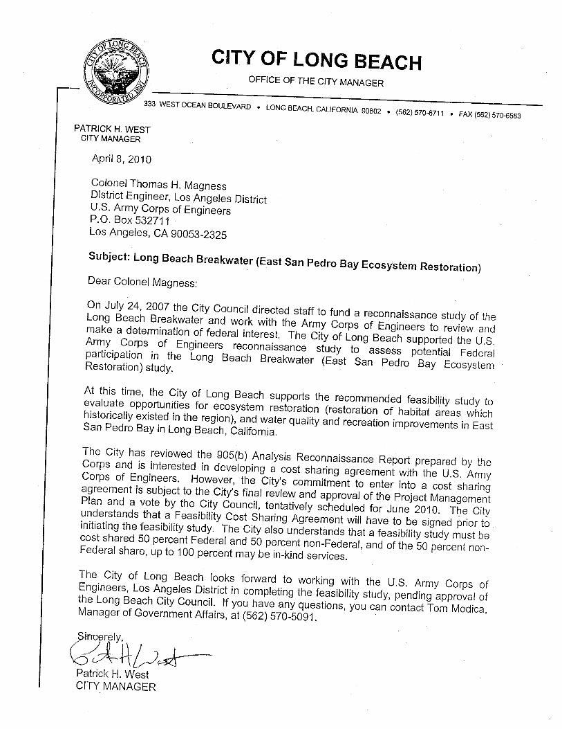
6. FEDERAL INTEREST Since there appear to be feasible and viable alternatives to potentially improve the degraded state of the Bay, there is Federal interest in conducting the feasibility study. In accordance with current administration policy, there is a federal interest in studies that provide a comprehensive approach to evaluating environmental restoration problems and opportunities that also effectively balances the need for sustainable economic development with the need for protection of natural resources, and this project study area has opportunities to provide for habitat restoration in a rapidly urbanizing environment. There is also a Federal interest in other related outputs of the alternatives including incidental recreational opportunities that could be developed within existing policy. Based on the preliminary screening of alternatives, there appears to be potential project alternatives that would be consistent with Army policies, costs, benefits, and environmental impacts. The reconnaissance study finds that there is a Federal interest in continuing the study into the feasibility phase. 7. PRELIMINARY FINANCIAL ANALYSIS As the local sponsor, the City of Long Beach will be required to provide 50 percent of the cost of the feasibility phase. The local sponsor is also aware of the cost sharing requirements for potential project implementation. A letter of intent from the local sponsor is included as Attachment B. 8. ASSUMPTIONS, EXCEPTIONS AND QUALITY OBJECTIVES 8.1 FEASIBILITY PHASE ASSUMPTIONS The following critical assumptions will provide a basis for the feasibility study: Without Project Condition Assumptions:
1. Continued degradation of the current East San Pedro Bay habitat will occur without intervention to correct deficiencies and restore an environment.
2. Existing development will remain and population will continue to increase with resultant impacts.
3. The demand for recreational activities in the study area will increase.
8.2 POLICY EXCEPTIONS AND STREAMLINING INITIATIVES The study will be conducted in accordance with the Principles and Guidelines and U. S. Army Corps of Engineers regulations. Exceptions to established guidance have not been identified at this time that will streamline the feasibility study process that will not adversely impact the quality of the feasibility study. Approval of the Section 905(b)
II - 27
Analysis by HQUSACE results in the approval of the following policy exceptions and streamlining initiatives:
1. The feasibility phase of study will require extensive coordination with the sponsor and public input, in relation to formulation of overall plans and other related projects in and around the Study Area.
2. Comprehensive project implementation with an overall coordination of projects
although some may be with other non-Federal sponsors or under different authorities.
3. NEPA and CEQA documentation will be prepared as part of an integrated
document package.
4. A Coordination Act Report (CAR) will be prepared by the U.S. Fish and Wildlife Service in support of the plan formulation process.
5. An incremental analysis will be performed as part of the evaluation of ecosystem
restoration alternatives
6. Further definition and analysis of proposed alternatives may lead to alternative Corps authorities for implementation.
7. An early, informal working relationship will be implemented with the various governmental
resource agencies. 8.3 QUALITY OBJECTIVES Feasibility Phase studies will be accomplished to meet the following quality objectives:
1. Information developed and subsequent project recommendations will be adequately described for the local sponsor to make an informed decision on future participation.
2. Quality control through the feasibility study phase will be in compliance with USACE of Engineers Quality Control Plan as documented in the Los Angeles District OM 1100-1-2.
II - 28
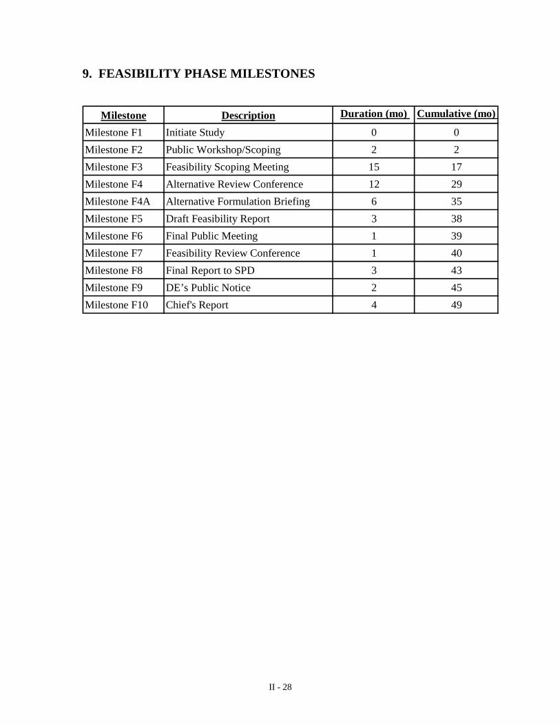
9. FEASIBILITY PHASE MILESTONES
Milestone Description Duration (mo) Cumulative (mo)
Milestone F1 Initiate Study 0 0
Milestone F2 Public Workshop/Scoping 2 2
Milestone F3 Feasibility Scoping Meeting 15 17
Milestone F4 Alternative Review Conference 12 29
Milestone F4A Alternative Formulation Briefing 6 35
Milestone F5 Draft Feasibility Report 3 38
Milestone F6 Final Public Meeting 1 39
Milestone F7 Feasibility Review Conference 1 40
Milestone F8 Final Report to SPD 3 43
Milestone F9 DE’s Public Notice 2 45
Milestone F10 Chief's Report 4 49
II - 29
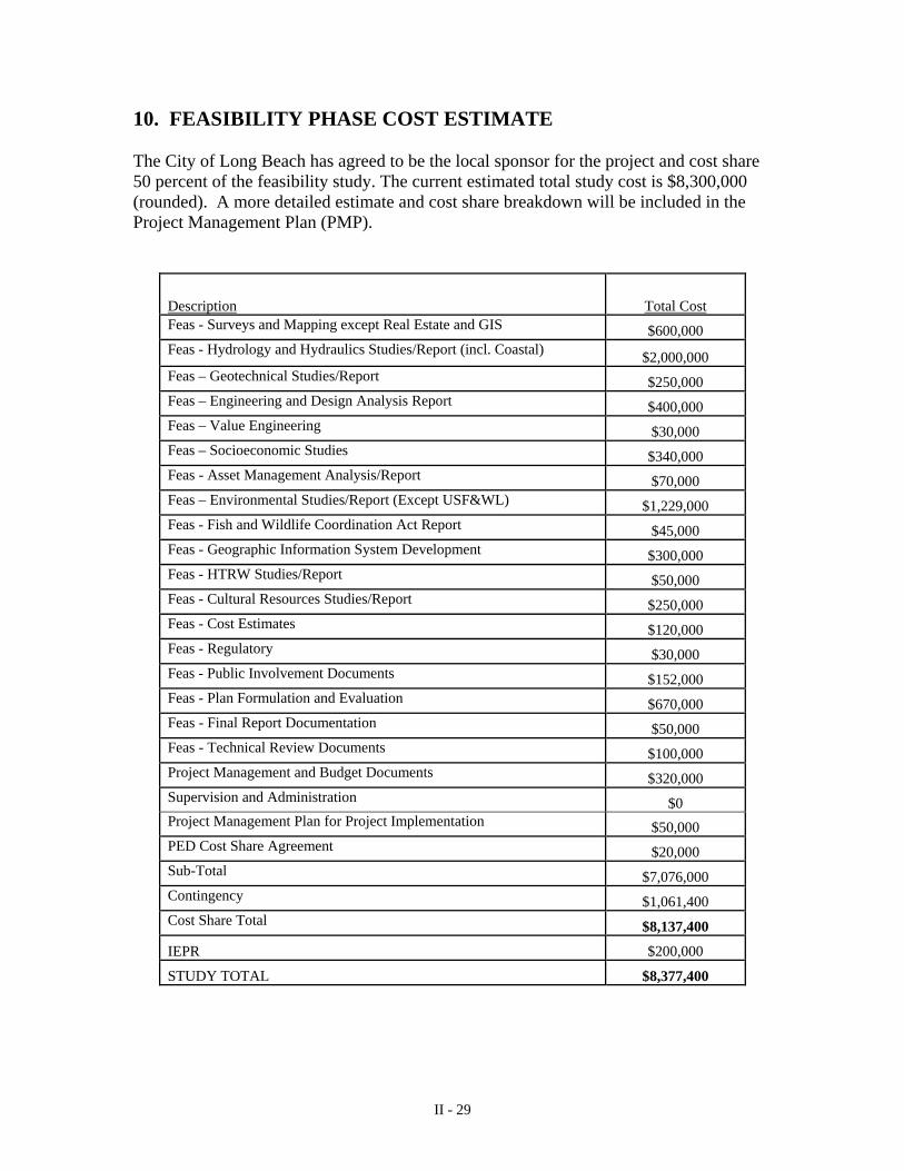
10. FEASIBILITY PHASE COST ESTIMATE The City of Long Beach has agreed to be the local sponsor for the project and cost share 50 percent of the feasibility study. The current estimated total study cost is $8,300,000 (rounded). A more detailed estimate and cost share breakdown will be included in the Project Management Plan (PMP).
Description Total Cost Feas - Surveys and Mapping except Real Estate and GIS $600,000 Feas - Hydrology and Hydraulics Studies/Report (incl. Coastal) $2,000,000 Feas – Geotechnical Studies/Report $250,000 Feas – Engineering and Design Analysis Report $400,000 Feas – Value Engineering $30,000 Feas – Socioeconomic Studies $340,000 Feas - Asset Management Analysis/Report $70,000 Feas – Environmental Studies/Report (Except USF&WL) $1,229,000 Feas - Fish and Wildlife Coordination Act Report $45,000 Feas - Geographic Information System Development $300,000 Feas - HTRW Studies/Report $50,000 Feas - Cultural Resources Studies/Report $250,000 Feas - Cost Estimates $120,000 Feas - Regulatory $30,000 Feas - Public Involvement Documents $152,000 Feas - Plan Formulation and Evaluation $670,000 Feas - Final Report Documentation $50,000 Feas - Technical Review Documents $100,000 Project Management and Budget Documents $320,000 Supervision and Administration $0 Project Management Plan for Project Implementation $50,000 PED Cost Share Agreement $20,000 Sub-Total $7,076,000 Contingency $1,061,400 Cost Share Total $8,137,400
IEPR $200,000
STUDY TOTAL $8,377,400
II - 30
11. POTENTIAL ISSUES AFFECTING INITIATION OF FEASIBILITY PHASE Continuation of this study into the cost-shared feasibility phase is contingent upon an executed Feasibility Cost Sharing Agreement (FCSA). Failure to achieve an executed FCSA within 18 months of the approval date of the Section 905(b) Analysis will result in termination of the study. The schedule for beginning the feasibility study is August 2010. Based on the schedule of milestones in Paragraph 9, completion of the feasibility report would be in September 2014. 12. PROJECT AREA MAP A map of the study area is provided as Attachment A. 13. RECOMMENDATIONS I recommend that the Long Beach Breakwater (East San Pedro Bay) Ecosystem Restoration Study proceed into the feasibility phase. The U.S. Army Corps of Engineers shall finalize negotiations of the Project management Plan and enter into a Feasibility Cost Sharing Agreement (FCSA) with the City of Long Beach. _____________ _____________________________
Date Thomas H. Magness Colonel, US Army District Engineer Los Angeles District
II - 31
ATTACHMENT A
(Project Study Area)
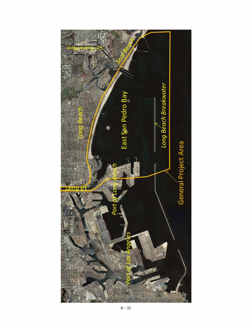
II - 32
Long Beach
Port of Los Angeles
Long Beach Breakwater
General Project Area
San Gabriel River
East San
Pedro Bay
Port of Long Beach
LA River
II - 33
ATTACHMENT B
(Letter from Sponsor)
II - 34
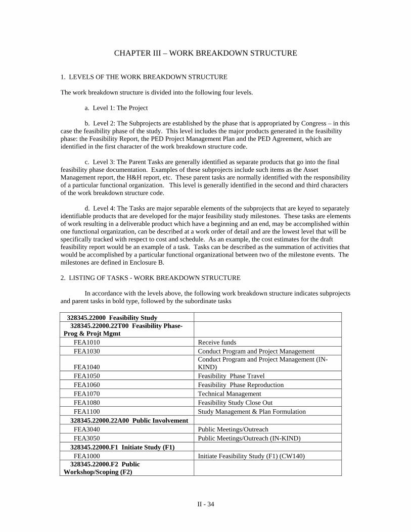
CHAPTER III – WORK BREAKDOWN STRUCTURE 1. LEVELS OF THE WORK BREAKDOWN STRUCTURE The work breakdown structure is divided into the following four levels.
a. Level 1: The Project b. Level 2: The Subprojects are established by the phase that is appropriated by Congress – in this
case the feasibility phase of the study. This level includes the major products generated in the feasibility phase: the Feasibility Report, the PED Project Management Plan and the PED Agreement, which are identified in the first character of the work breakdown structure code.
c. Level 3: The Parent Tasks are generally identified as separate products that go into the final feasibility phase documentation. Examples of these subprojects include such items as the Asset Management report, the H&H report, etc. These parent tasks are normally identified with the responsibility of a particular functional organization. This level is generally identified in the second and third characters of the work breakdown structure code. d. Level 4: The Tasks are major separable elements of the subprojects that are keyed to separately identifiable products that are developed for the major feasibility study milestones. These tasks are elements of work resulting in a deliverable product which have a beginning and an end, may be accomplished within one functional organization, can be described at a work order of detail and are the lowest level that will be specifically tracked with respect to cost and schedule. As an example, the cost estimates for the draft feasibility report would be an example of a task. Tasks can be described as the summation of activities that would be accomplished by a particular functional organizational between two of the milestone events. The milestones are defined in Enclosure B. 2. LISTING OF TASKS - WORK BREAKDOWN STRUCTURE In accordance with the levels above, the following work breakdown structure indicates subprojects and parent tasks in bold type, followed by the subordinate tasks
328345.22000 Feasibility Study 328345.22000.22T00 Feasibility Phase-Prog & Projt Mgmt FEA1010 Receive funds FEA1030 Conduct Program and Project Management
FEA1040 Conduct Program and Project Management (IN-KIND)
FEA1050 Feasibility Phase Travel FEA1060 Feasibility Phase Reproduction FEA1070 Technical Management FEA1080 Feasibility Study Close Out FEA1100 Study Management & Plan Formulation 328345.22000.22A00 Public Involvement FEA3040 Public Meetings/Outreach FEA3050 Public Meetings/Outreach (IN-KIND) 328345.22000.F1 Initiate Study (F1) FEA1000 Initiate Feasibility Study (F1) (CW140) 328345.22000.F2 Public Workshop/Scoping (F2)
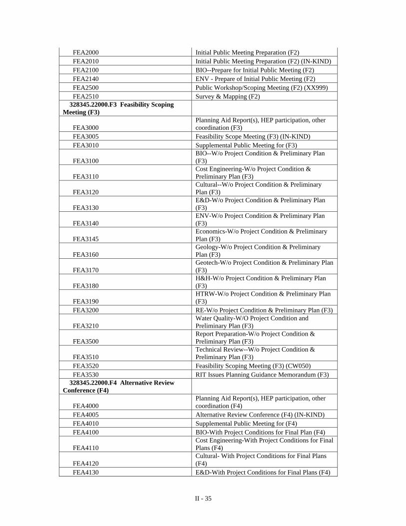
II - 35
FEA2000 Initial Public Meeting Preparation (F2) FEA2010 Initial Public Meeting Preparation (F2) (IN-KIND) FEA2100 BIO--Prepare for Initial Public Meeting (F2) FEA2140 ENV - Prepare of Initial Public Meeting (F2) FEA2500 Public Workshop/Scoping Meeting (F2) (XX999) FEA2510 Survey & Mapping (F2) 328345.22000.F3 Feasibility Scoping Meeting (F3)
FEA3000 Planning Aid Report(s), HEP participation, other coordination (F3)
FEA3005 Feasibility Scope Meeting (F3) (IN-KIND) FEA3010 Supplemental Public Meeting for (F3)
FEA3100 BIO--W/o Project Condition & Preliminary Plan (F3)
FEA3110 Cost Engineering-W/o Project Condition & Preliminary Plan (F3)
FEA3120 Cultural--W/o Project Condition & Preliminary Plan (F3)
FEA3130 E&D-W/o Project Condition & Preliminary Plan (F3)
FEA3140 ENV-W/o Project Condition & Preliminary Plan (F3)
FEA3145 Economics-W/o Project Condition & Preliminary Plan (F3)
FEA3160 Geology-W/o Project Condition & Preliminary Plan (F3)
FEA3170 Geotech-W/o Project Condition & Preliminary Plan (F3)
FEA3180 H&H-W/o Project Condition & Preliminary Plan (F3)
FEA3190 HTRW-W/o Project Condition & Preliminary Plan (F3)
FEA3200 RE-W/o Project Condition & Preliminary Plan (F3)
FEA3210 Water Quality-W/O Project Condition and Preliminary Plan (F3)
FEA3500 Report Preparation-W/o Project Condition & Preliminary Plan (F3)
FEA3510 Technical Review--W/o Project Condition & Preliminary Plan (F3)
FEA3520 Feasibility Scoping Meeting (F3) (CW050) FEA3530 RIT Issues Planning Guidance Memorandum (F3) 328345.22000.F4 Alternative Review Conference (F4)
FEA4000 Planning Aid Report(s), HEP participation, other coordination (F4)
FEA4005 Alternative Review Conference (F4) (IN-KIND) FEA4010 Supplemental Public Meeting for (F4) FEA4100 BIO-With Project Conditions for Final Plan (F4)
FEA4110 Cost Engineering-With Project Conditions for Final Plans (F4)
FEA4120 Cultural- With Project Conditions for Final Plans (F4)
FEA4130 E&D-With Project Conditions for Final Plans (F4)
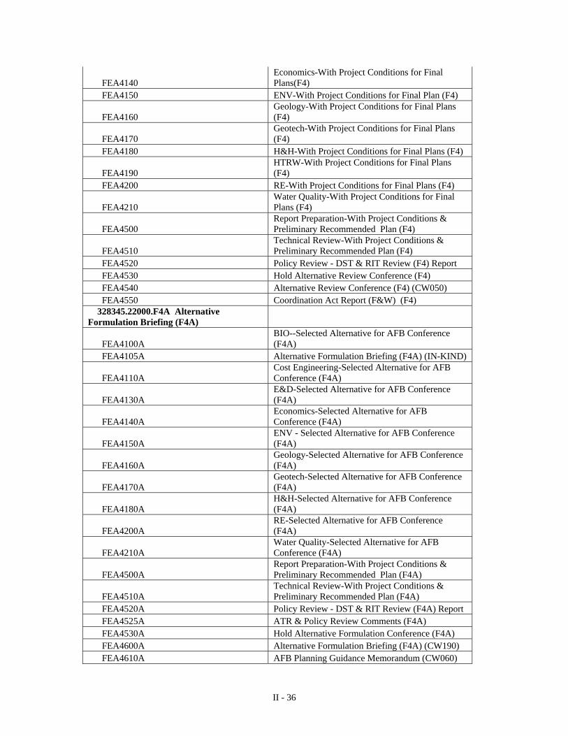
II - 36
FEA4140 Economics-With Project Conditions for Final Plans(F4)
FEA4150 ENV-With Project Conditions for Final Plan (F4)
FEA4160 Geology-With Project Conditions for Final Plans (F4)
FEA4170 Geotech-With Project Conditions for Final Plans (F4)
FEA4180 H&H-With Project Conditions for Final Plans (F4)
FEA4190 HTRW-With Project Conditions for Final Plans (F4)
FEA4200 RE-With Project Conditions for Final Plans (F4)
FEA4210 Water Quality-With Project Conditions for Final Plans (F4)
FEA4500 Report Preparation-With Project Conditions & Preliminary Recommended Plan (F4)
FEA4510 Technical Review-With Project Conditions & Preliminary Recommended Plan (F4)
FEA4520 Policy Review - DST & RIT Review (F4) Report FEA4530 Hold Alternative Review Conference (F4) FEA4540 Alternative Review Conference (F4) (CW050) FEA4550 Coordination Act Report (F&W) (F4) 328345.22000.F4A Alternative Formulation Briefing (F4A)
FEA4100A BIO--Selected Alternative for AFB Conference (F4A)
FEA4105A Alternative Formulation Briefing (F4A) (IN-KIND)
FEA4110A Cost Engineering-Selected Alternative for AFB Conference (F4A)
FEA4130A E&D-Selected Alternative for AFB Conference (F4A)
FEA4140A Economics-Selected Alternative for AFB Conference (F4A)
FEA4150A ENV - Selected Alternative for AFB Conference (F4A)
FEA4160A Geology-Selected Alternative for AFB Conference (F4A)
FEA4170A Geotech-Selected Alternative for AFB Conference (F4A)
FEA4180A H&H-Selected Alternative for AFB Conference (F4A)
FEA4200A RE-Selected Alternative for AFB Conference (F4A)
FEA4210A Water Quality-Selected Alternative for AFB Conference (F4A)
FEA4500A Report Preparation-With Project Conditions & Preliminary Recommended Plan (F4A)
FEA4510A Technical Review-With Project Conditions & Preliminary Recommended Plan (F4A)
FEA4520A Policy Review - DST & RIT Review (F4A) Report FEA4525A ATR & Policy Review Comments (F4A) FEA4530A Hold Alternative Formulation Conference (F4A) FEA4600A Alternative Formulation Briefing (F4A) (CW190) FEA4610A AFB Planning Guidance Memorandum (CW060)
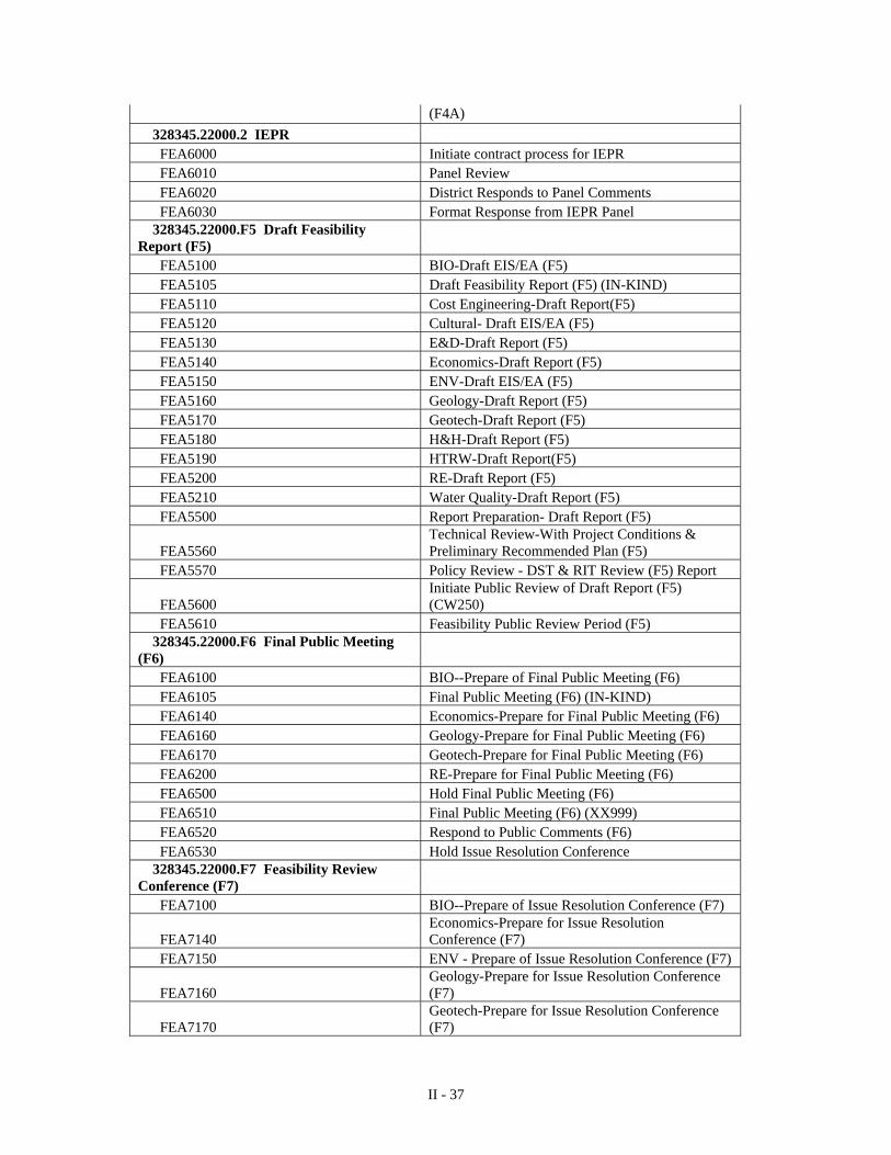
II - 37
(F4A)
328345.22000.2 IEPR FEA6000 Initiate contract process for IEPR FEA6010 Panel Review FEA6020 District Responds to Panel Comments FEA6030 Format Response from IEPR Panel 328345.22000.F5 Draft Feasibility Report (F5) FEA5100 BIO-Draft EIS/EA (F5) FEA5105 Draft Feasibility Report (F5) (IN-KIND) FEA5110 Cost Engineering-Draft Report(F5) FEA5120 Cultural- Draft EIS/EA (F5) FEA5130 E&D-Draft Report (F5) FEA5140 Economics-Draft Report (F5) FEA5150 ENV-Draft EIS/EA (F5) FEA5160 Geology-Draft Report (F5) FEA5170 Geotech-Draft Report (F5) FEA5180 H&H-Draft Report (F5) FEA5190 HTRW-Draft Report(F5) FEA5200 RE-Draft Report (F5) FEA5210 Water Quality-Draft Report (F5) FEA5500 Report Preparation- Draft Report (F5)
FEA5560 Technical Review-With Project Conditions & Preliminary Recommended Plan (F5)
FEA5570 Policy Review - DST & RIT Review (F5) Report
FEA5600 Initiate Public Review of Draft Report (F5) (CW250)
FEA5610 Feasibility Public Review Period (F5) 328345.22000.F6 Final Public Meeting (F6) FEA6100 BIO--Prepare of Final Public Meeting (F6) FEA6105 Final Public Meeting (F6) (IN-KIND) FEA6140 Economics-Prepare for Final Public Meeting (F6) FEA6160 Geology-Prepare for Final Public Meeting (F6) FEA6170 Geotech-Prepare for Final Public Meeting (F6) FEA6200 RE-Prepare for Final Public Meeting (F6) FEA6500 Hold Final Public Meeting (F6) FEA6510 Final Public Meeting (F6) (XX999) FEA6520 Respond to Public Comments (F6) FEA6530 Hold Issue Resolution Conference 328345.22000.F7 Feasibility Review Conference (F7) FEA7100 BIO--Prepare of Issue Resolution Conference (F7)
FEA7140 Economics-Prepare for Issue Resolution Conference (F7)
FEA7150 ENV - Prepare of Issue Resolution Conference (F7)
FEA7160 Geology-Prepare for Issue Resolution Conference (F7)
FEA7170 Geotech-Prepare for Issue Resolution Conference (F7)
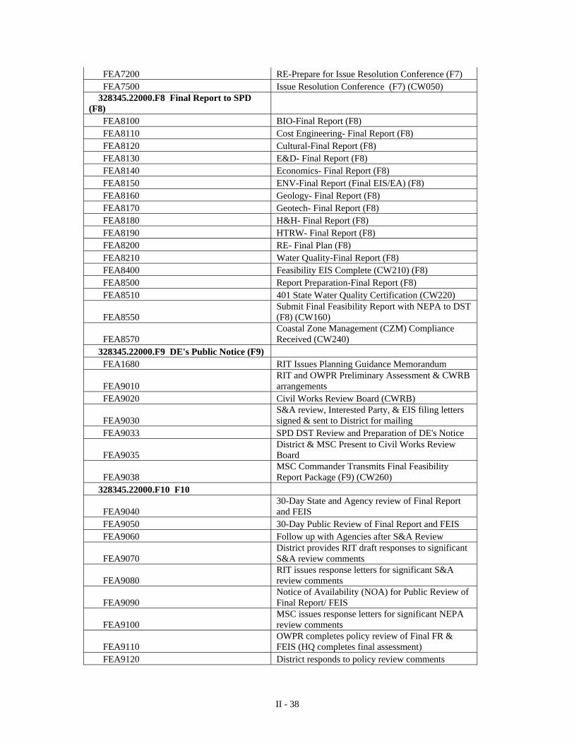
II - 38
FEA7200 RE-Prepare for Issue Resolution Conference (F7) FEA7500 Issue Resolution Conference (F7) (CW050) 328345.22000.F8 Final Report to SPD (F8) FEA8100 BIO-Final Report (F8) FEA8110 Cost Engineering- Final Report (F8) FEA8120 Cultural-Final Report (F8) FEA8130 E&D- Final Report (F8) FEA8140 Economics- Final Report (F8) FEA8150 ENV-Final Report (Final EIS/EA) (F8) FEA8160 Geology- Final Report (F8) FEA8170 Geotech- Final Report (F8) FEA8180 H&H- Final Report (F8) FEA8190 HTRW- Final Report (F8) FEA8200 RE- Final Plan (F8) FEA8210 Water Quality-Final Report (F8) FEA8400 Feasibility EIS Complete (CW210) (F8) FEA8500 Report Preparation-Final Report (F8) FEA8510 401 State Water Quality Certification (CW220)
FEA8550 Submit Final Feasibility Report with NEPA to DST (F8) (CW160)
FEA8570 Coastal Zone Management (CZM) Compliance Received (CW240)
328345.22000.F9 DE's Public Notice (F9) FEA1680 RIT Issues Planning Guidance Memorandum
FEA9010 RIT and OWPR Preliminary Assessment & CWRB arrangements
FEA9020 Civil Works Review Board (CWRB)
FEA9030 S&A review, Interested Party, & EIS filing letters signed & sent to District for mailing
FEA9033 SPD DST Review and Preparation of DE's Notice
FEA9035 District & MSC Present to Civil Works Review Board
FEA9038 MSC Commander Transmits Final Feasibility Report Package (F9) (CW260)
328345.22000.F10 F10
FEA9040 30-Day State and Agency review of Final Report and FEIS
FEA9050 30-Day Public Review of Final Report and FEIS FEA9060 Follow up with Agencies after S&A Review
FEA9070 District provides RIT draft responses to significant S&A review comments
FEA9080 RIT issues response letters for significant S&A review comments
FEA9090 Notice of Availability (NOA) for Public Review of Final Report/ FEIS
FEA9100 MSC issues response letters for significant NEPA review comments
FEA9110 OWPR completes policy review of Final FR & FEIS (HQ completes final assessment)
FEA9120 District responds to policy review comments
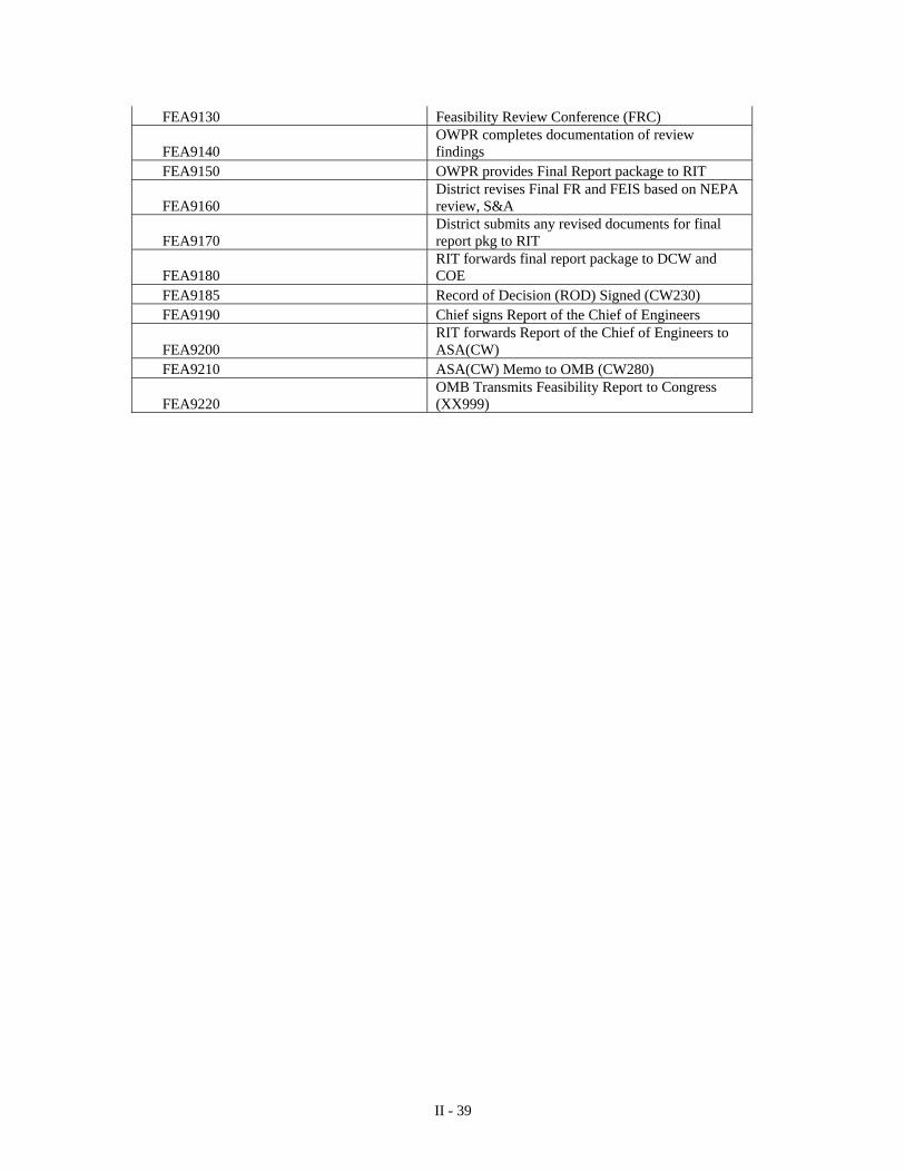
II - 39
FEA9130 Feasibility Review Conference (FRC)
FEA9140 OWPR completes documentation of review findings
FEA9150 OWPR provides Final Report package to RIT
FEA9160 District revises Final FR and FEIS based on NEPA review, S&A
FEA9170 District submits any revised documents for final report pkg to RIT
FEA9180 RIT forwards final report package to DCW and COE
FEA9185 Record of Decision (ROD) Signed (CW230) FEA9190 Chief signs Report of the Chief of Engineers
FEA9200 RIT forwards Report of the Chief of Engineers to ASA(CW)
FEA9210 ASA(CW) Memo to OMB (CW280)
FEA9220 OMB Transmits Feasibility Report to Congress (XX999)
IV - 1
CHAPTER IV – SCOPES OF WORK 1. DETAILED SCOPES OF WORK For each task that is included in the work breakdown structure, a scope of work is developed that describes the work that is to be performed. For each task, the scope describes the work, including specific activities, to be accomplished in narrative form. The scopes of work have been developed by the study team, which includes representatives of the non-Federal sponsor. The scopes also reflect the policy exceptions and streamlining initiatives that have been approved in the Section 905(b) Analysis. The detailed scopes of work for the feasibility study are organized by parent task in Enclosure C. 2. DURATIONS OF TASKS The durations for the tasks are entered into the project’s network analysis system (NAS) to develop the schedule that is included in Chapter VI – Schedule. The durations are based on negotiations between the Project Manager and the chiefs of the responsible organizations, as identified in Chapter V, Responsibility Assignment. 3. COSTS OF TASKS Lastly, the scopes of work for the tasks are grouped by the parent tasks that they support. The total estimates for the parent tasks are then combined in the Feasibility Cost Estimate, Chapter VII. The cost estimates for the tasks are also based on negotiations between the Project Manager and the chiefs of the responsible organizations.
V- 1
CHAPTER V – RESPONSIBILITY ASSIGNMENT 1. ORGANIZATIONAL BREAKDOWN STRUCTURE The scopes of work represent agreements between the Project Manager and first line supervisors of functional organizations. The functions of these organizations in support of the project are defined by the work that is assigned. All organizations responsible for tasks, including the local sponsor and other agencies, are listed with their organization codes in the following Organizational Breakdown Structure (OBS). OBS: USACE Los Angeles District OBS: Local Sponsor and Other Agencies
Name Code City of Long Beach COLB U. S. Fish and Wildlife Service USFWS National Oceanographic and Atmospheric Agency NOAA
Other Agencies/Counties/Cities and other Interest Groups stated in the Public Involvement section in Enclosure C.
OTHER
Division/Branch/Section Organization Code CESPD-
Engineering// ED Engineering/Design/Coastal/ ED-DC Engineering/Design/Cost/ ED-DS Engineering/Geotechnical/Geology ED-GG Engineering/Geotechnical/Soils ED-GD Engineering/Survey & Mapping/ ED-GS Planning// PD Planning/Economics/ PD-E Planning/Environmental/Cultural PD-RL Planning/Environmental/ PD-RN Planning/Water Resources/ PD-W Planning/Water Resources/Coastal Studies Group PD-WS Project Management// PM- Project Management/Navigation/ PM-N Project Management/Programs/ PM-P Asset Management// AM Asset Management/Civil Works Branch/ AM-CW Regulatory// RG
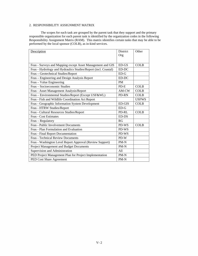
V- 2
2. RESPONSIBILITY ASSIGNMENT MATRIX The scopes for each task are grouped by the parent task that they support and the primary responsible organization for each parent task is identified by the organization codes in the following Responsibility Assignment Matrix (RAM). This matrix identifies certain tasks that may be able to be performed by the local sponsor (COLB), as in-kind services. Description District
Org Other
Feas - Surveys and Mapping except Asset Management and GIS ED-GS COLB Feas - Hydrology and Hydraulics Studies/Report (incl. Coastal) ED-DC Feas – Geotechnical Studies/Report ED-G Feas – Engineering and Design Analysis Report ED-DC Feas – Value Engineering PM Feas – Socioeconomic Studies PD-E COLB Feas - Asset Management Analysis/Report AM-CW COLB Feas – Environmental Studies/Report (Except USF&WL) PD-RN COLB Feas - Fish and Wildlife Coordination Act Report USFWS Feas - Geographic Information System Development ED-GIS COLB Feas - HTRW Studies/Report ED-G Feas - Cultural Resources Studies/Report PD-RL COLB Feas - Cost Estimates ED-DS Feas – Regulatory RG Feas - Public Involvement Documents PD-WS COLB Feas - Plan Formulation and Evaluation PD-WS Feas - Final Report Documentation PD-WS Feas - Technical Review Documents PD-W Feas - Washington Level Report Approval (Review Support) PM-N Project Management and Budget Documents PM-N Supervision and Administration All PED Project Management Plan for Project Implementation PM-N PED Cost Share Agreement PM-N
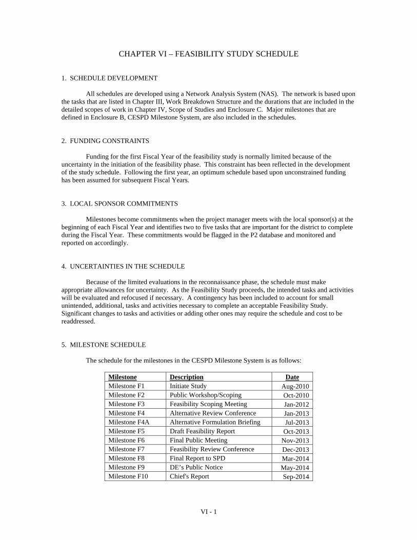
VI - 1
CHAPTER VI – FEASIBILITY STUDY SCHEDULE 1. SCHEDULE DEVELOPMENT All schedules are developed using a Network Analysis System (NAS). The network is based upon the tasks that are listed in Chapter III, Work Breakdown Structure and the durations that are included in the detailed scopes of work in Chapter IV, Scope of Studies and Enclosure C. Major milestones that are defined in Enclosure B, CESPD Milestone System, are also included in the schedules. 2. FUNDING CONSTRAINTS Funding for the first Fiscal Year of the feasibility study is normally limited because of the uncertainty in the initiation of the feasibility phase. This constraint has been reflected in the development of the study schedule. Following the first year, an optimum schedule based upon unconstrained funding has been assumed for subsequent Fiscal Years. 3. LOCAL SPONSOR COMMITMENTS Milestones become commitments when the project manager meets with the local sponsor(s) at the beginning of each Fiscal Year and identifies two to five tasks that are important for the district to complete during the Fiscal Year. These commitments would be flagged in the P2 database and monitored and reported on accordingly. 4. UNCERTAINTIES IN THE SCHEDULE Because of the limited evaluations in the reconnaissance phase, the schedule must make appropriate allowances for uncertainty. As the Feasibility Study proceeds, the intended tasks and activities will be evaluated and refocused if necessary. A contingency has been included to account for small unintended, additional, tasks and activities necessary to complete an acceptable Feasibility Study. Significant changes to tasks and activities or adding other ones may require the schedule and cost to be readdressed. 5. MILESTONE SCHEDULE The schedule for the milestones in the CESPD Milestone System is as follows:
Milestone Description Date Milestone F1 Initiate Study Aug-2010 Milestone F2 Public Workshop/Scoping Oct-2010 Milestone F3 Feasibility Scoping Meeting Jan-2012 Milestone F4 Alternative Review Conference Jan-2013 Milestone F4A Alternative Formulation Briefing Jul-2013 Milestone F5 Draft Feasibility Report Oct-2013 Milestone F6 Final Public Meeting Nov-2013 Milestone F7 Feasibility Review Conference Dec-2013 Milestone F8 Final Report to SPD Mar-2014 Milestone F9 DE’s Public Notice May-2014 Milestone F10 Chief's Report Sep-2014
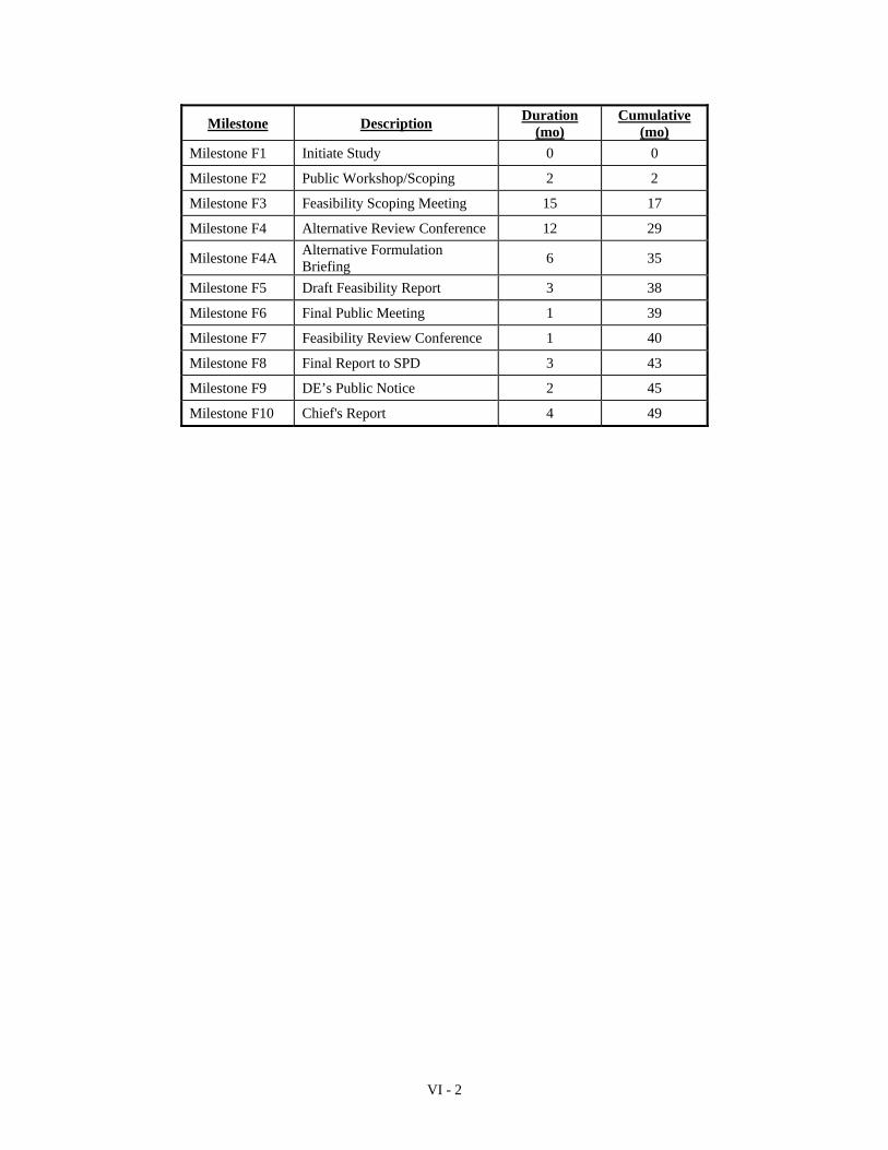
VI - 2
Milestone Description Duration
(mo) Cumulative
(mo)
Milestone F1 Initiate Study 0 0
Milestone F2 Public Workshop/Scoping 2 2
Milestone F3 Feasibility Scoping Meeting 15 17
Milestone F4 Alternative Review Conference 12 29
Milestone F4A Alternative Formulation Briefing
6 35
Milestone F5 Draft Feasibility Report 3 38
Milestone F6 Final Public Meeting 1 39
Milestone F7 Feasibility Review Conference 1 40
Milestone F8 Final Report to SPD 3 43
Milestone F9 DE’s Public Notice 2 45
Milestone F10 Chief's Report 4 49
VII - 1
CHAPTER VII – FEASIBILITY COST ESTIMATE 1. BASIS FOR THE COST ESTIMATE a. The feasibility cost estimate is based upon a summation of the costs that were identified for the individual tasks in detailed scopes of work that are included in Enclosure C, Detailed Scopes of Work. Significant inflation could require the schedule and cost to be renegotiated. b. Appropriate contingencies and contingency management are included to adequately deal with the uncertainty in the elements of the study. Experience has shown that approximately 15 percent of the study costs should be reserved for activities after the release of the draft report. Contingencies in this amount have been added to the cost estimate. 2. COSTS FOR FEDERAL AND NON-FEDERAL ACTIVITIES The non-Federal sponsor must contribute 50 percent of the cost of the study during the period of the study. The non-Federal sponsor may contribute up to 100% of the non-Federal share by the provision of services, materials, supplies or other in-kind services necessary to prepare the feasibility report. The feasibility cost estimate below we refined from the estimates presented in the 905(b) and includes credit for work that could be potentially accomplished by the non-Federal sponsor.
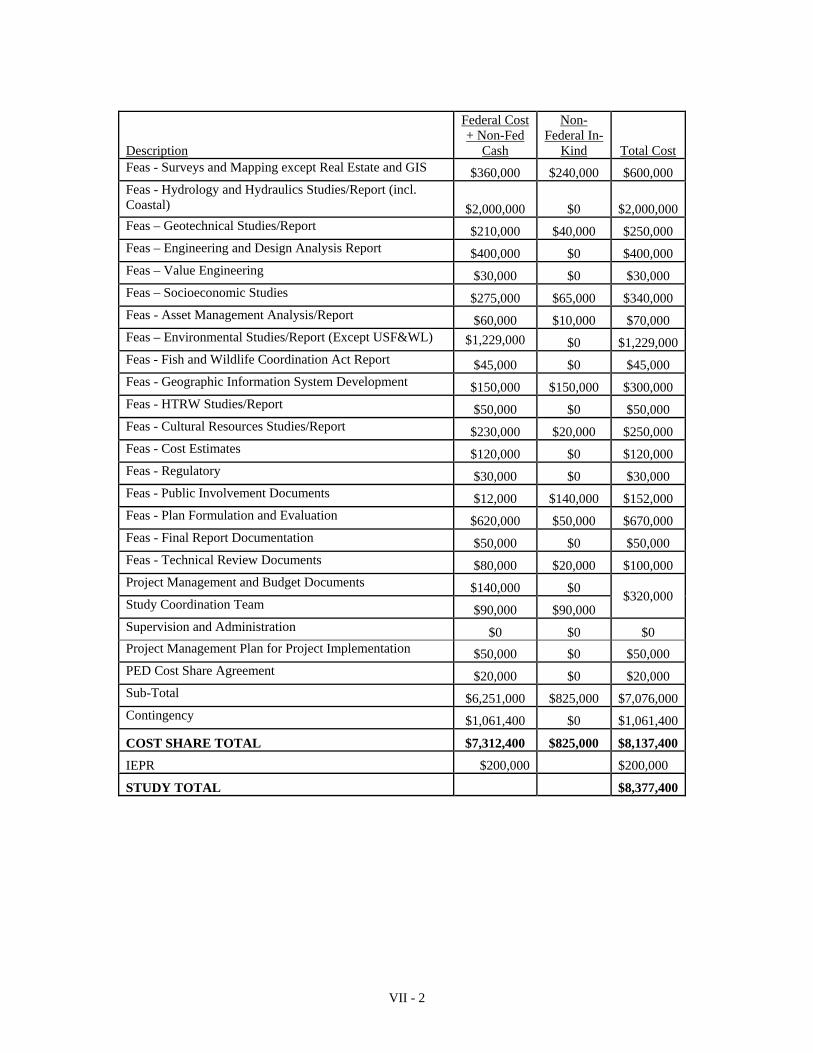
VII - 2
Description
Federal Cost + Non-Fed
Cash
Non-Federal In-
Kind Total Cost Feas - Surveys and Mapping except Real Estate and GIS $360,000 $240,000 $600,000 Feas - Hydrology and Hydraulics Studies/Report (incl. Coastal) $2,000,000 $0 $2,000,000Feas – Geotechnical Studies/Report $210,000 $40,000 $250,000 Feas – Engineering and Design Analysis Report $400,000 $0 $400,000 Feas – Value Engineering $30,000 $0 $30,000 Feas – Socioeconomic Studies $275,000 $65,000 $340,000 Feas - Asset Management Analysis/Report $60,000 $10,000 $70,000 Feas – Environmental Studies/Report (Except USF&WL) $1,229,000 $0 $1,229,000Feas - Fish and Wildlife Coordination Act Report $45,000 $0 $45,000 Feas - Geographic Information System Development $150,000 $150,000 $300,000 Feas - HTRW Studies/Report $50,000 $0 $50,000 Feas - Cultural Resources Studies/Report $230,000 $20,000 $250,000 Feas - Cost Estimates $120,000 $0 $120,000 Feas - Regulatory $30,000 $0 $30,000 Feas - Public Involvement Documents $12,000 $140,000 $152,000 Feas - Plan Formulation and Evaluation $620,000 $50,000 $670,000 Feas - Final Report Documentation $50,000 $0 $50,000 Feas - Technical Review Documents $80,000 $20,000 $100,000 Project Management and Budget Documents $140,000 $0
$320,000 Study Coordination Team $90,000 $90,000 Supervision and Administration $0 $0 $0 Project Management Plan for Project Implementation $50,000 $0 $50,000 PED Cost Share Agreement $20,000 $0 $20,000 Sub-Total $6,251,000 $825,000 $7,076,000Contingency $1,061,400 $0 $1,061,400
COST SHARE TOTAL $7,312,400 $825,000 $8,137,400
IEPR $200,000 $200,000
STUDY TOTAL $8,377,400
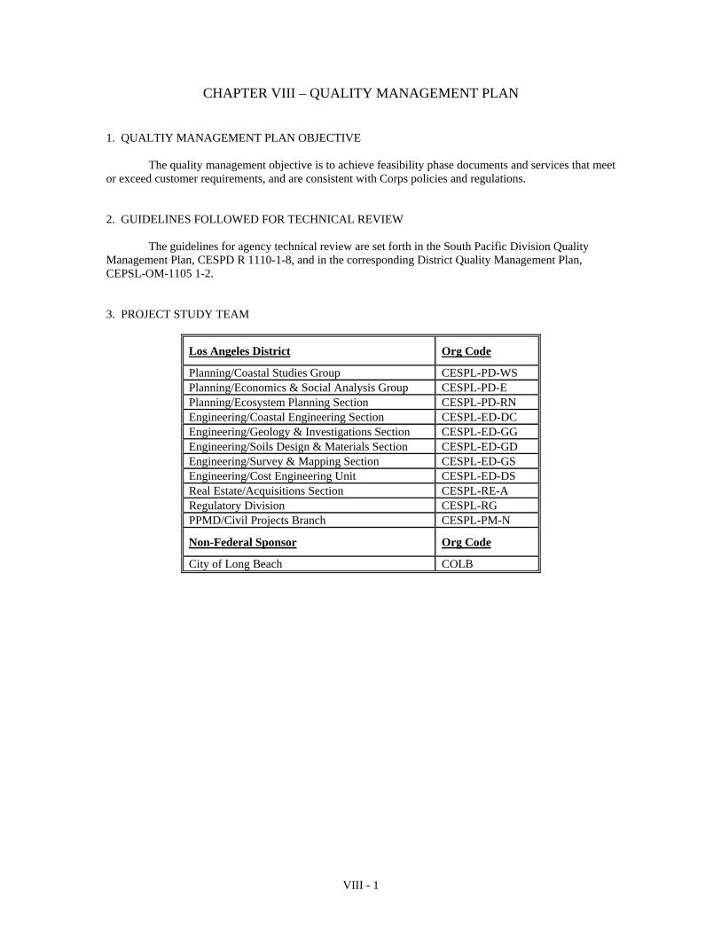
VIII - 1
CHAPTER VIII – QUALITY MANAGEMENT PLAN
1. QUALTIY MANAGEMENT PLAN OBJECTIVE The quality management objective is to achieve feasibility phase documents and services that meet or exceed customer requirements, and are consistent with Corps policies and regulations. 2. GUIDELINES FOLLOWED FOR TECHNICAL REVIEW The guidelines for agency technical review are set forth in the South Pacific Division Quality Management Plan, CESPD R 1110-1-8, and in the corresponding District Quality Management Plan, CEPSL-OM-1105 1-2. 3. PROJECT STUDY TEAM
Los Angeles District Org Code
Planning/Coastal Studies Group CESPL-PD-WS Planning/Economics & Social Analysis Group CESPL-PD-E Planning/Ecosystem Planning Section CESPL-PD-RN Engineering/Coastal Engineering Section CESPL-ED-DC Engineering/Geology & Investigations Section CESPL-ED-GG Engineering/Soils Design & Materials Section CESPL-ED-GD Engineering/Survey & Mapping Section CESPL-ED-GS Engineering/Cost Engineering Unit CESPL-ED-DS Real Estate/Acquisitions Section CESPL-RE-A Regulatory Division CESPL-RG PPMD/Civil Projects Branch CESPL-PM-N
Non-Federal Sponsor Org Code
City of Long Beach COLB
VIII - 2
4. TECHNICAL REVIEW TEAM A Review Plan will be developed to describe the scope and execution of review for the East San Pedro Bay Ecosystem Restoration Feasibility Study, in accordance with Engineering Circular 1105-2-410, Review of Decision Documents (August 22, 2008). The Review Plan is a stand-alone component of the East San Pedro Bay Ecosystem Restoration Feasibility Study Project Management Plan (PMP).
Agency Technical Review (ATR) is an in-depth review, managed within USACE, and conducted
by a qualified team outside of the home district that is not involved in the day-to-day production of a project/product. The purpose of this review is to ensure the proper application of clearly established criteria, regulations, laws, codes, principles and professional practices. The ATR team reviews the various work products and assures that all the parts fit together in a coherent whole. ATR teams will be comprised of senior USACE personnel (Regional Technical Specialists (RTS), etc.), and may be supplemented by outside experts as appropriate. To assure independence, the leader of the ATR team shall be from outside the home MSC.
Independent External Peer Review (IEPR) is an external review conducted by experts independent
of the Corps of Engineers. The ECO-PCX will contract with an outside eligible organization (OEO) to manage IEPR. The OEO will select IEPR panel members using the National Academy of Science’s policy for selecting reviewers. The IEPR panel will consist of recognized independent experts from outside of USACE, with disciplines appropriate for the type of review being conducted. The ECO-PCX will make the final decision regarding the disciplines and number of panel members. 5. DOCUMENTS TO BE REVIEWED AND SCHEDULE FOR REVIEW ACTIVITES A detailed scope and schedule of the documents to be reviewed will be described in the Review Plan (RP). The decision documents prepared for the East San Pedro Bay Ecosystem Restoration Feasibility Study will be subject to four types of review: District Quality Control (DQC), Agency Technical Review (ATR), Independent External Peer Review (IEPR), public review, state and agency review, and Washington-level Policy and Compliance Reviews. The RP will list the requirements for each of the reviews, a schedule for each review, and coordination with the Planning Center of Expertise, and the expertise needed for each reviewer.
A Seamless Single Discipline Review will be accomplished prior to the release of materials to other members of the study team or integrated into the overall study. Section chiefs shall be responsible for accuracy of the computations through design checks and other internal procedures, prior to the agency technical review.
Agency product review will occur prior to major decision points in the planning process at the CESPD milestones so that the technical results can be relied upon in setting the course for further study. These products would include documentation for the CESPD mandatory milestone conferences (F3 & F4), HQUSACE issue resolution conferences (AFB &FRC) and the draft and final reports. These products shall be essentially complete before review is undertaken. Since this quality control will have occurred prior to each milestone conference, the conference is free to address critical outstanding issues and set direction for the next step of the study, since a firm technical basis for making decisions will have already been established. In general, the agency technical review will be initiated at least two week prior to a CESPD mandatory milestone conference and at least two weeks prior to the submission of documentation for a HQUSACE issue resolution conference. For products that are developed under contract, the contractor will be responsible for quality control through ATR. Quality assurance of the contractor’s quality control will be the responsibility of the district.
VIII - 3
6. DEVIATIONS FROM THE APPROVED QUALITY MANGEMENT PLAN No deviations from the Quality Management Plan are proposed. 7. COST ESTIMATE FOR QUALITY MANAGEMENT The costs for conducting agency technical review are included in the individual scopes of work that are included in Chapter IV, Scope of Studies. Quality management activities of Branch and Division Chiefs are included within the specific tasks. 8. PMP QUALITY CERTICATION The Chief, Planning Division has certified that 1) the agency technical review process for this PMP has been completed, 2) all issues have been addressed, 3) the streamlining initiatives proposed in this PMP will result in a technically adequate product, and 4) appropriate quality control plan requirements have been adequately incorporated into this PMP. The signed certification is included as Enclosure D.
9. FEASIBILITY PHASE CERTIFICATION The documentation of the agency technical review shall be included with the submission of the reports to CESPD. Documentation of the agency technical review shall be accompanied by a certification, indicating that the agency technical review process has been completed and that all technical issues have been resolved. The certification requirement applies to all documentation that will be forwarded to either CESPD or HQUSACE for review or approval. The Chief, Planning Division will certify the pre-conference documentation for the HQUSACE issue resolution conferences and the draft feasibility report. The District Commander will certify the final feasibility report, which includes the signed recommendation of the District Commander. This certification will follow the example that is included as Appendix H of the CESPD Quality Management Plan and will be signed by the Chief, Planning Division and the District Commander.
IX - 1
CHAPTER IX IDENTIFICATON OF PROCEDURES AND CRITERIA 1. EVOLUTION OF THE PMP
The PMP describes all activities from the initial tasks of the feasibility phase through the
preparation of the final feasibility report, the project management plan for project implementation and design agreement, and conclude with the district's support during the USACE Headquarters (HQUSACE) review. As the PMP is based primarily on existing information, it will be subject to scope changes as the technical picture unfolds. While this PMP includes tasks through the completion of the feasibility study, the level of detail in the scopes of work are greater for those tasks that occur prior to the first milestone conference. This plan will be reviewed at the first milestone conference and additional detail will be added to the scopes of work for the subsequent tasks. During the feasibility phase of the study, the current PMP, including the documentation of agreements on changes to the conduct of the study, will be addressed at each of the CESPD milestone conferences and at the formal issue resolution conferences with HQUSACE, including the AFB and FRC. 2. THE PLANNING PROCESS
The Water Resource Council's Principles and Guidelines (P&G) is the basic planning guidance,
which establishes a six-step planning process. This process is a conceptual planning sequence for developing solutions to water resource problems and opportunities. The Planning Manual and Planning Primer, both published by IWR provide excellent coverage of the planning process. The South Pacific Division also provides training in the six- step process. 3. POLICY The policies that govern the development of projects are contained in the DIGEST OF WATER RESOURCES POLICIES AND AUTHORITIES, EP 1165-2-1. 4. CORPS REGULATIONS All of the Corps’ current regulations are included on the HQUSACE homepage. The most important of these regulations is ER 1105-2-100, PLANNING GUIDANCE NOTEBOOK. Policy compliance review is addressed in EC 1165-2-203, TECHNICAL AND POLICY COMPLIANCE REVIEW. And, quality control is covered in the CESPD Quality Management Plan, CESPD R 1110-1-8. The review of the products will be accomplished with the review checklist that is provided in EC 1165-2-203 as Appendix B, POLICY COMPLIANCE REIVEW CONSIDERATIONS. 6. PROCESSING REQUIREMENTS In addition to ER 1105-2-100, the South Pacific Division has provided additional guidance on the processing requirements for each of the milestone submittals. This guidance is contained in CESPD-ET-P memorandum, dated 30 March 2000, subject: Processing of Planning Reports in the South Pacific Division.
X - 1
CHAPTER X – COORDINATION MECHANISMS
1. CESPD MILESTONES Two of the milestones in the CESPD milestone system have been established specifically for the purpose of providing a public forum to receive public input. The first of these is the initial public workshop. This workshop is an opportunity to present the study to the public, obtain input and public opinions, and fulfill the NEPA scoping meeting requirements. The second milestone in the system is the final public meeting. This meeting is after the release of the draft report for public review and is an opportunity to present the findings of the draft report to the public and receive public comment. 2. STUDY SPECIFIC PUBLIC INVOLVEMENT ACTIVITIES In addition to the two public meetings mentioned above, this study includes six public outreach meetings. These meetings are designed to provide multiple opportunities for involvement of local and interested citizens and other interest groups and agencies. The Sponsor has primary responsibility for setting up and organizing these meetings. The Corps will participate in them.

ENCLOSURE A – PROJECT AREA MAP
A-1
Long Beach
Port of Los Angeles
Long Beach Breakw
ater
General Project Area
San Gabriel River
East San
Pedro Bay
Port of Long Beach
LA River
ENCLOSURE B – CESPD MILESTONE SYSTEM
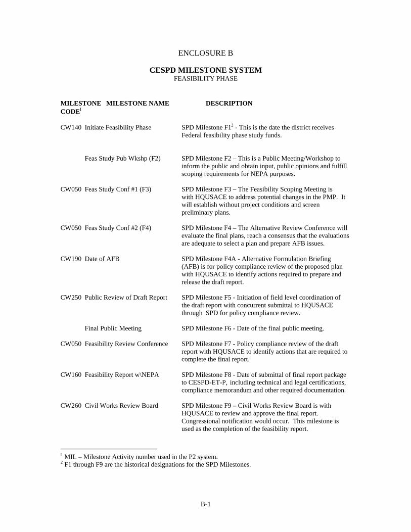
B-1
ENCLOSURE B
CESPD MILESTONE SYSTEM FEASIBILITY PHASE
MILESTONE MILESTONE NAME DESCRIPTION CODE CW140 Initiate Feasibility Phase SPD Milestone F1 - This is the date the district receives Federal feasibility phase study funds. Feas Study Pub Wkshp (F2) SPD Milestone F2 – This is a Public Meeting/Workshop to inform the public and obtain input, public opinions and fulfill scoping requirements for NEPA purposes. CW050 Feas Study Conf #1 (F3) SPD Milestone F3 – The Feasibility Scoping Meeting is with HQUSACE to address potential changes in the PMP. It will establish without project conditions and screen preliminary plans. CW050 Feas Study Conf #2 (F4) SPD Milestone F4 – The Alternative Review Conference will evaluate the final plans, reach a consensus that the evaluations are adequate to select a plan and prepare AFB issues. CW190 Date of AFB SPD Milestone F4A - Alternative Formulation Briefing (AFB) is for policy compliance review of the proposed plan with HQUSACE to identify actions required to prepare and release the draft report. CW250 Public Review of Draft Report SPD Milestone F5 - Initiation of field level coordination of the draft report with concurrent submittal to HQUSACE through SPD for policy compliance review. Final Public Meeting SPD Milestone F6 - Date of the final public meeting. CW050 Feasibility Review Conference SPD Milestone F7 - Policy compliance review of the draft report with HQUSACE to identify actions that are required to complete the final report. CW160 Feasibility Report w\NEPA SPD Milestone F8 - Date of submittal of final report package to CESPD-ET-P, including technical and legal certifications, compliance memorandum and other required documentation. CW260 Civil Works Review Board SPD Milestone F9 – Civil Works Review Board is with HQUSACE to review and approve the final report. Congressional notification would occur. This milestone is used as the completion of the feasibility report.
MIL – Milestone Activity number used in the P2 system. 2 F1 through F9 are the historical designations for the SPD Milestones.
B-2
MIL MILESTONE NAME DESCRIPTION
CW210 Filing of Final EIS/EA Date that the notice appears in the Federal Register. Letters for filing would be furnished by HQUSACE.
CW270 Chief’s Report to ASA (CW) SPD Milestone F10 - Date of the signed report of the Chief of Engineers. CW230 ROD Signed or FONSI Signed Date that the ROD is signed by the ASA(CW) when forwarded for authorization. CW280 ASA (CW) Memo to OMB Date of the transmittal to OMB. This Milestone completes the Feasibility Phase per ER 1105-2-100
MIL – Milestone number used in the P2 system.
ENCLOSURE C – DETAILED SCOPES OF WORK
C-1
The following sections provide a discussion of the work tasks with the corresponding activities, grouped by the appropriate discipline.
The following activities and assumptions are included in the scopes contained below as well as their respective costs.
(1) Study team members will participate in study team meetings. (2) Study team members will participate in site visit.
(3) Study team members, when appropriate, will attend public and/or outreach meetings. (4) Study team members will prepare their respective documents prior to each milestone requiring documentation (F3, F4, F4A, F5, F8, and F9). (5) Formal technical review costs are not included as part of the documents preparation costs. However, informal technical review or seamless review is included in each task and activity estimate. (6) Supervision and Administration costs are included in the task and activity scopes and estimates. (7) Inflation and nominal cost changes are included in the study cost. If the national inflation rate is in excess of 3.5% in any year or significant cost changes occur, the PMP may need to be revised.
Feasibility Report
The Feasibility Report encompasses all tasks to be performed during the preparation of the feasibility report documentation. Its primary function is for cost accounting and separating tasks from other phases of project implementation (i.e. from Reconnaissance, Planning Engineering and Design, and Construction). Milestones
The milestones are defined in Chapter II, Section 9 of this document. All milestones have zero
duration, no cost and a specific end date. The milestones will be used to keep the study schedule on track and will be the primary focus for the Executive Management Committee. Engineering Studies
Engineering studies are comprised of Surveys and Mapping, Hydrodynamics and Hydraulics, Coastal Engineering, Geotechnical and Engineering Design and Cost Estimating. Each organization’s tasks and activities are described below. The feasibility study, engineering appendix, will contain sufficient engineering detail to support recommendations and enhance decisions making ability related to project management plans, projects and other issues.
C-2
Surveys and Mapping (except Asset Management and GIS) ($600,000) Surveys and Mapping – Without Project Conditions: F3 ($200,000)+ In-kind($240,000) This task includes the review of existing topographic and bathymetric data, organization of the data and the creation of maps to aid in defining the baseline condition within the project area; and collection of new bathymetric and lidar surveys. Multi-beam bathymetry of San Pedro Bay from the western boundary of the COLB to the Approach Channel of Anaheim Bay, including Alamitos Bay and the Marine Stadium, will be surveyed. The offshore area seaward of the Long Beach breakwater to a distance about 2000 feet offshore of the breakwater will be surveyed. In addition, existing structures that maybe modified will be surveyed to capture both above and below water high-resolution surfaces with an on-board laser scanning/multi-beam survey system. Structures to be included are the Long Beach Breakwater, the four energy islands, the perimeter of the POLB east of Pier J, The Alamitos Bay Jetties and the COLB shoreline, to include the outside perimeter of the Downtown Marina and the Los Angeles River to the Queensway Bridge. This information will be used to support other functional elements within the project delivery team. The Surveyor-Engineer shall compile a topographic survey from a combination of aerial mapping, ground-based field surveying and hydrographic surveying. The survey data will be used for hydrologic, hydraulic, and other models in the evaluation of potential design alternatives. Aerial photographs will be ortho-corrected to ensure that they correspond with topographic mapping and can be easily added to GIS. Aerial mapping should include photography to allow for a map accuracy of 1"= 50' ( 1 ft. contour interval). Lidar data may be incorporated where available.
1. Scope of Services:
Review of existing topographic and bathymetric data. (Shoreline information from either the National Mapping Program of the Scripps LIDAR is expected to be available for the COLB shoreline and improvements)
1-ft contour interval
Mapping of 1 inch = 100 ft (for 2ft. contours) or Mapping of 1 inch = 50 ft. (for 1ft contours)
Digital color orthophotography. (Existing ortho-images is expected to be adequate).
Label all levees, bridges, streets, and all other standard map labeling.
Perform Multi-beam bathymetric survey at San Pedro Bay.
Perform Laser scanning/multi beam survey of Long Beach Breakwater, and other structures within East San Pedro Bay.
2. Terrain Model Specifications:
Digital Terrain Model (DTM) in Triangular Irregular Network (TIN) format for mapped areas.
Ortho grade DTM for orthophotography
3. Deliverables:
Negatives (1 set)
Contact Prints (2 sets)
Photo Index
Microstation .DGN files with contours generated from the DTM
Terrain Model
DTM data in ArcGIS TIN/.e00, Microstation/Inroads dgn/.dtm, and ASCII text formats
Five sets Digital Ortho-photography, .half-foot pixels.
C-3
x,y,z .pts file format of mass points representing surface
Five sets of breakline .brk file used for creating surface
4. Reports (5 sets) to include:
Quality Assurance/Quality Control Report.
“Corpsmet95” metadata file.
All monuments set-found-used described on DA Form 1959 and in Wordpad format on CD.
Mapping is to be compiled in the 1983 North American Datum (NAD 1983) for horizontal control, and the 1988 North American Vertical Datum (NAVD 88) for vertical control. It must meet the “National Map Accuracy Standards”, “Federal Geodetic Control Standards” and the following Corps of Engineering Manuals:
EM 1110-1-1807, “Standards Manual for U.S. Army Corps of Engineers Computer-Aided Design and Drafting (CADD) Systems”.
EM 1110-1-1002, “Survey Markers and Monumentation” dated 14 September 1990
EM 1110-1-1005, “Topographic Surveying” dated 31August 1994.
EM 1110-2-1003, “Hydrographic Surveying” dated 01January 2002.
EM 1110-1-1000, “Photogrammetric Mapping” dated 01July 2002.
EM 1110-1-1003, “NAVSTAR Global Positioning System Surveying” dated 01 July 2003
Corps of Engineers program “Corpsmet95” for metadata. The completed CAD files shall be three-dimensional and fully operational and compatible on the Corps of Engineers system. The Los Angeles District is presently utilizing Intergraph MicroStation and Inroads. All drawings for the Corps shall be stored in Intergraph or MicroStation file format on Compact Disk(s) (CD). Each drawing shall have a separate file name and be stored individually on the disk(s). The files should also be delivered in ESRI data format. Topographic maps, digital files and aerial ortho-photographs shall be supplied to the hydrologic / hydraulic sections of the Corps and other study team members. Surveys and Mapping – With Project Conditions: F4 ($160,000) After review and evaluation of collected data, additional needs will be defined. Cost and schedule will be reviewed to obtain required information. Surveys and Mapping – AFB Documentation: F4A No additional mapping is planned after the F4 milestone. Surveys and Mapping – Draft Report: F5 No additional mapping is planned after the F4 milestone.
Surveys and Mapping – Final Report
No additional mapping is planned after the F4 milestone.
C-4
Hydrology and Hydraulics Studies/Report (Coastal Engineering) ($2,000,000)
This section describes analysis of wave transformation, harbor resonance, shoreline morphology, water circulation and water quality modeling. The overall hydrodynamics of San Pedro Bay will be modeled to include the forcing by tides, waves and surface water flows of the Los Angeles River, the San Gabriel River and Dominguez Channel. A shoreline morphology model and a sediment fate model will be included. The goal is to identify environmental restoration opportunities to restore and increase benthic habitat, restore fisheries, increase recreational opportunities and improve water quality in East San Pedro Bay. Flood control, Port of Long Beach wave protection, shoreline protection, and navigational aspects of the San Pedro Bay area must not be adversely affected. The hydrodynamic model and water quality model developed for the project area will be coupled with the wave model in terms of boundary conditions. The circulation modeling will require a 3-dimensional formulation to account for stratified river inflow and vertical velocity gradients. The expected model types are listed as follows:
1) Phase averaging spectral wave model for short wave propagation (CMS-Wave). 2) 3-D Circulation Model (ADH or CMS-FLOW). 3) Phase resolving model for long wave resonance evaluation (BOUSSINESQ 2-D). 4) Water Quality Model coupled to 2) above (CE-QUAL). 5) Sediment Transport/Fate model coupled to 2) above. 6) Shoreline Evolution Model.
Coastal - Without Project Conditions: F3 ($1,257,500)
The basic tasks in Coastal modeling include:
1. Collect and review existing information regarding topographic mapping; bathymetric information; tidal elevations; circulation; water quality; sediment transport, shoreline position, beach profiles, winds, waves and relevant coastal structure plans in order to establish baseline conditions. Review existing shoreline operational and maintenance requirements.
2. Coordinate with Corps of Engineers, City of Long Beach, EPA , Water Board and relevant
agencies and consultants to identify obtain and review all relevant coastal engineering reports and prepare a brief summary. Coordinate with GIS unit regarding data protocols.
3. Perform a field reconnaissance study to confirm baseline information by examining and
verifying the collected information. Additional data collection efforts, such as tidal elevation, current velocity, wave height/period, water quality, shoreline position, beach profile and sediment characteristic measurements will be identified for further study in order to complete the establishment of the system baseline information. Coordinate with the Corps of Engineers to determine the preferred spatial and temporal coverage of the field data collection effort.
4. Evaluate and establish hydrodynamic, water quality and sediment transport characteristics of
project sites under existing and future without project conditions by utilizing the information collected and reviewed from task 1 to task 3.
5. Update wave climate through transformed GROW hindcast for stations along the breakwater.
6. Perform wave transformation, shoreline morphology, water circulation, sediment transport and water quality numerical models to encompass the San Pedro Bay, (including the breakwater area, LA River, Port of Long Beach, local beaches, marinas, and military facilities) to assist in the preliminary development of the measures and alternative plans. Perform harbor resonance model for entire San Pedro Bay complex.
7. Develop design parameters for sizing and layout of project alternatives. 8. Attend meetings and prepare documents for the F3 milestone and participate in F3
conference.
C-5
Coastal - With Project Conditions: F4 ($488,900)
1. Assist in developing and designing measures and alternatives for environmental restoration
and recreational enhancement purposes. Hydrodynamic circulation, wave transformation, water quality and sediment properties are the major design criteria to be considered for the habitat restoration and recreational enhancements. All relevant design features, including breakwater modifications, reef structures, wave protection structures, shoreline protection structures, river training structures, existing Port/military facilities, beaches, marinas,, etc. will be incorporated in the alternative plans.
2. Coordinate with biologists and marine ecosystem specialists to develop the relationship between water quality improvement and ecosystem restoration benefits. Establish design criteria related to water quality, clarity, and nearshore habitat structural design/materials. Identify target depths and locations for the creation of reef and kelp habitats.
3. Perform wave transformation, shoreline morphology, water circulation, sediment transport and water quality numerical models to encompass the San Pedro Bay. Perform harbor resonance model for entire San Pedro Bay complex.. Various alternatives and features will be modeled and simulated for design reference. Computation grids will be generated and tested. The coastal models will be simulated and verified against available data. Water quality and sediment transport models will be driven by the results of hydrodynamic and wave modeling (i.e. water elevations, velocities and sheer stresses). Coordinate with GIS unit to appropriately integrate and display results.
4. Perform coastal engineering design based on computer simulation results of the alternatives. All the designs have to meet with the design specifications developed by the project team members. Iteration procedure will be adopted to refine the alternatives.
5. Attend meetings, coordinate as required and assist in plan formulation and selection of the
preferred alternative plans. 6. Prepare coastal engineering documents for the F4 milestone and participate in F4 conference.
Coastal - AFB Documents: F4A ($108,200)
1. Attend meetings, incorporate comments and update report documents for the AFB milestone. Coastal - Draft Report: F5 ($82,200)
2. Attend meetings, incorporate comments and update report documents for the F5 milestone. Coastal - Final Report: F8 ($56,200)
1. Attend meetings, incorporate comments and update report documents for the F8 milestone
2. Respond to comments as necessary.
C-6
Geotechnical Studies/Report ($250,000) The Geotechnical work for this study will consist of characterizing the geologic setting and properties of the study area and presenting the findings in a geotechnical appendix. Detailed site-specific investigations will be conducted to fill in data gaps in existing information. These investigations may include drilling, sampling, coring and testing of soils as required for design. Descriptions of the activities follow. Geologic Studies - Without Project Conditions (F3) ($141,900) + In-Kind ($40,000) Geologic Framework Research. This task consists of summarizing existing published and/or unpublished information relating to:
1. Regional/Site Geology and Topography
2. Geologic Hazards, such as seismicity (regional and local), location of nearby faults, regional groundwater and subsidence (if any). Drill and case shallow observation wells to determine the depths of the local site groundwater at a particular site or reach of the channel.
3. Sources of construction stone. This task will research sources of any additional stone for
proposed construction of wave/shoreline protection structures or reefs.
4. Field Explorations. This task covers preliminary field explorations to determine the soils types for foundation studies. Prior to initiating this task a field reconnaissance would be conducted in order to locate the sites for drilling and trenching and obtain rights-of-entry.
Characterize sediment quality of the existing bay bottom sediments within East San Pedro Bay for the purpose of benthic habitat quality determination. Conduct baseline surveys, source identification, and evaluation of the LA River Basin to track contaminant sources and pathways. Include grab samples, chemistry analysis, and tiered bioassay analysis.
5. Laboratory Testing. Soils sampled from the drilling coring and grab sampling operations will
undergo sieve analysis tests in order to determine their grain size and engineering characteristics in accordance with the Unified Soil Classification System.
6. Documentation of the Study. This task covers the documentation and technical review of the
geologic studies and includes coordination required in assembling the Geotechnical Appendix. Plates, figures and tables will be prepared as a part of the Appendix.
Geology – With Project Conditions: F4 ($17,000)
1. Participate with others in the study team to develop measures and plans for potential projects.
2. Assess the impacts of potential conceptual alternatives.
3. Update the report. Geology – AFB Documentation ($3,500)
1. Update the report.
Geology – Draft Report: F5 ($3,700)
1. Update the report. Geology – Final Report: F5-F9 ($3,900)
C-7
1. Review and revise final report.
2. Attend and participate in meetings. Soils – Without Project Conditions: F3($16,400)
1. Research, collect, and review data.
2. Plan and participate in field explorations including soil sampling to determine presence of contaminants.
3. Prepare input to F3 document and draft appendix.
4. Review F3 document.
5. Attend and participate in meetings. Soils – With Project Conditions: F4 ($16,000)
1. Research, collect, and review data.
2. Participate in alternative development.
3. Preliminary design and construction considerations.
4. Prepare input to F4 document and draft appendix.
5. Review F4 document and draft appendix.
6. Attend and participate in meetings Soils – AFB Documentation: F4A ($2,400)
3. Revise F4 document and draft appendix. Soils – Draft Report ($2,500)
1. Review and revise draft report.
2. Attend and participate in meetings. Soils – Final Report ($2,600)
4. Review and revise final report.
5. Attend and participate in meetings.
C-8
Engineering and Design Analysis/Report ($400,000) This study is expected to result in a recommended plan. Engineering and Design will be involved with the development and illustration of the alternatives and presentation of the design of the recommended plan, which includes breakwater modifications, reef creation, wave protection structures, shoreline protection structures, river training structures, navigational aids, etc. Conceptual layouts for all the features and alternatives will be prepared. Services for cost estimating are included under separate paragraph k. Cost Estimates (JH000). This section describes the general tasks that are planned for Engineering and Design. Engineering and Design - Without Project Conditions: F3 ($113,400)
1. Attend and participate meetings with study team in development of preliminary conceptual measures and plans for all identified management units.
2. Assist in preliminary development of measures and plans.
3. Perform field survey to identify preliminary impacts to existing facilities and shorelines.
4. Review, compile and integrate existing available and/or new topographical and hydrographic
survey maps to prepare project drawings. 5. Prepare layouts for existing and without project conditions.
7. Cooperate with GIS format preparation for the project plans.
8. Prepare F3 documentation including drawings.
9. Attend F3 Conference.
Engineering and Design - With Project Conditions: F4 ($231,000)
1. Assist in defining expected performance of the potential plans for the identified management units.
2. Prepare quantities for cost estimates for all alternatives. 3. Assist in plan formulation, in-house review, respond to comments, and support to the Lead
Planner and other study team members.
4. Develop design features and prepare quantities for cost estimates for all recommended plans.
5. Draft plans for expected recommended plans.
6. Prepare F4 documentation. Layout details for project alternatives and recommended plans including project drawings.
7. Attend F4 conference.
Engineering and Design - AFB Document: F4A ($31,200)
1. Attend meeting, update plans and designs.
2. Respond to comments, review and revise documents.
C-9
6. Refine conceptual design of recommended alternatives.
Engineering and Design - Draft Report: F5 ($18,700)
1. Attend meeting, respond to comments and update plans and designs.
7. Prepare F5 documentation. Engineering and Design - Final Report: F8 ($18,700)
1. Attend meeting, respond to comments, review and revise plans, designs, documents and report.
Value Engineering ($30,000) A Value Engineering Plan (VEP) is required for all projects exceeding $2,000,000 and a Review of the Cost Effectiveness of Design (VE Study) must be conducted on all projects that exceed $10,000,000 (CESPD R 11-1-3). The purpose of the VEP is to assure the lowest level of project life cycle costs without sacrificing quality, aesthetics, operational capability, and maintenance capability. This VEP delineates the responsibilities of the Project Manager, the District's Value Engineering Officer (VEO) and the Local Sponsor to comply with VE requirements. The Project Manager and the VEO are responsible for coordinating the VE studies and providing support to the overall VE effort as it relates to this project. The points of contact within the key District organizations are: (a) - Project Manager:
Monica Eichler Programs and Project Management Division U.S. Army Corps of Engineers, Los Angeles District Telephone: (213) 452-4012 (b) - Value Engineering Officer (VEO) and VEP prepared by: Arnecia Bradley Value Engineering Officer, U.S. Army Corps of Engineers, Los Angeles District Telephone: (213) 452-3747 The applicable laws, policy, regulations, and circulars are as follows:
(a) - Congressional Law - Section 911 of the Water Resources Development Act of 1986.
(b) - USACE Policy - Perform Value Engineering studies on all USACE projects with a programmed cost of $2,000,000 or greater when cost effective.
(c) - Regulations and Circulars: (1) AR 5-4 and OCE Supplement 1. (2) ER 1110-2-150.
C-10
(3) EC 11-1-114
(4) CESPD Regulation 11-1-3. (5) CESPD Guidance dated September 30, 2003 A Value Engineering Study on the East San Pedro Bay Ecosystem Restoration project has not been performed to date. The Local Sponsor has a vested interest in the project, and therefore would have an interest in the Value Engineering process. The Local Sponsor will be invited to participate fully in Value Engineering studies performed on the project, during the entire design and construction life of the project. The Project Manager and the VEO will coordinate the scheduling of the Value Engineering studies for the project. The project will be studied with one VE Study during the Feasibility Phase (F3 – F4) and one VE Study during the Planning, Engineering Design (PED) Phase. The Project Manager will coordinate the funding requirements for accomplishing the studies indicated above. Funding will be required during FY 2011 for the Feasibility Phase VE Study and during FY 2013 for the PED Phase VE Study. VE on this project will be accomplished with the following methods: (1) - Value Engineering Study(s).
(2) - Value Engineering Proposals (to be submitted by Corps Employees and/or A-E contractors)
(3) - Value Engineering Change Proposals (submitted by construction contractors). The 1st VE Study will use the Feasibility Phase Report, as the basis for the VE Study. The 2nd VE Study should be accomplished prior to the completion of the plans and specifications during the PED Phase. Value Engineering during construction, should be accomplished so as not to impact on the schedule for construction phases. Value Engineering at this stage is accomplished by VECP’s and construction change orders and construction modifications. It should be understood that all the time and money spent applying the Value Engineering effort will not always result in realized savings, but the effort and the cost should be considered as a cost of design and doing business. Socioeconomic Studies ($275,000) + In-kind($65,000) Economics- Baseline Conditions Analysis: F1-F3 ($112,300) For the F3 milestone economic analyses will inventory and forecast the without project conditions for critical resources relevant to the problems and opportunities identified in the reconnaissance report. Each economic task, described below, is listed according to the analysis it supports. The analyses are grouped into the following seven categories: demographic, ecosystem restoration, coastal storm damage, recreation, deep draft navigation, regional economic development (RED) and other social effects (OSE). Other non-technical economic tasks required in support of these analyses are listed as an eighth category. The tasks described under the coastal storm damage, recreation and deep draft navigation sections are a good faith estimate of the level of analysis required to reach the F3 milestone. The actually analysis may require more or less work depending on the extent to which the without project condition is expected to change due to the project.
I. Demographic – Economics will inventory and forecast the without project study area demographics.
Specific economic tasks required to complete this analysis include:
1. Define Area of Impact – It is necessary to define the project’s likely area of impact, before without project demographic conditions can be inventoried and forecast. The project’s likely area of
C-11
impact will be defined based on: input from PDT members and local experts, professional judgment, and preliminary demographic research.
2. Data Collection – Data describing land use, resident, visitor and business demographics in the study area will be collected from a variety of sources.
3. Data Analysis – Demographic data will be evaluated and forecast in order to obtain the without project demographic condition.
II. Ecosystem Restoration – Economics will coordinate with the PDT to inventory and forecast without project ecosystem conditions. Specific economic tasks required to complete this analysis include:
1. Coordination with the PDT – Coordination with the PDT is required to ensure without project habitat data collection methods yield information that can be used to make future with project comparisons. In particular, the data must be compatible with the required incremental cost and cost effectiveness analyses.
2. Data Collection - Baseline and forecast without project habitat data must be obtained before the F3 milestone.
III. Coastal Storm Damage – The reconnaissance study recognizes the following key coastal storm damage constraint:
Shoreline structures and beaches. Existing residences, public infrastructure marinas, other structures and recreational beaches must be protected from increases in erosion, wave related damages and coastal flooding.
To reach the F3 milestone economics will inventory and forecast without project coastal storm damages. Economic tasks, associated with the without project coastal storm damage analysis include:
1. Coordination with the PDT - Significant coordination with PDT team members, especially the
coastal engineer, will be necessary to ensure without project coastal storm damages can be forecast. At a minimum costal storm data, provided by the coastal engineer, will need to project the probabilistic likelihood of damaging events caused by short period wave events and beach erosion. It will also need to project the likelihood of these events at a number of heterogeneous study area locations, including:
i. The Long Beach shoreline; ii. Downtown Long Beach Marina;
iii. THUMBS islands (4); and iv. Port of Long Beach.
The coastal engineer is expected to use the Beach-Fx program to generate data from Monte Carlo lifecycle simulations of coastal storm events in the study area.
2. Property Inventory– An inventory of properties susceptible to coastal storm damage will be developed using the products described under the Surveys and Mapping – Without Project Condition heading in the Scopes of Work chapter of this PMP.
C-12
3. Develop GIS Database – The property inventory, coastal engineering data and other study area characteristics will be incorporated into a GIS database.
4. Structure and Content Valuation –The value of structures located on properties susceptible to damage will be determined using Marshal and Swift Valuation Service Multipliers. These multipliers base structure valuations on square footage estimates, type of construction, estimated depreciation and location specific factors. This data will be obtained through tax assessor’s data and field surveys. The value of structure contents will be estimated by multiplying structure values by fixed percentages associated with the structure use.
5. Structure and Content Damage Analysis – Without project economic damages will be computed
using a lifecycle simulation approach over a 50-year period of analysis, employing the prevailing federal interest rate. A lifecycle simulation methodology is necessary so that the cumulative effects of events in previous time periods is taken into account when projecting future time periods expected annual damages. A 50 year time period and the prevailing federal interest rate is applied to the analysis so that expected future damages are evaluated in present values. Key model parameters will be represented by probability distributions, rather than deterministic values. Distribution functions are likely to be derived using the Beach-Fx program. Potential risk and uncertainty parameters in the analysis will include: annual erosion rates; storm-to-structure damage function percentages; as well as land, structure and content values.
6. Other Damage Categories – An assessment of other coastal storm damages in the study area will
be made. These including: emergency and cleanup costs; transportation impacts; vehicle damages; etc… The reconnaissance report mentions impacts to ammunitions transfers at the U.S. Navy’s Explosive Anchorage site as a planning constraint. Since the economics group anticipates that this planning constraint will be met, an economic evaluation of impacts to ammunition transfer operations is expected to be unnecessary. However, if the PDT determines that impacts to ammunition transfer area are likely, then the without project conditions associated with this damage category will need to be analyzed, as part of the coastal storm damage analysis.
The resulting without project coastal storm damage analysis will comply with all risk and uncertainty guidance contained in ER 1105-2-100, ER 1105-2-101, and EM 1110-2-1619.
IV. Recreation – The reconnaissance study specifies the following recreation planning objective:
To increase recreational opportunities (surfing, beach use, tourism, etc.) in East San Pedro Bay and its immediate surrounding beaches and beach communities;
A comprehensive without project recreation analysis will be completed before the F3 milestone. This analysis will serve as a baseline, against which various recreation plans will be compared. Economic tasks associated with the without project recreation analysis include:
1. Recreation Market – Based on interviews with local experts, such as Long Beach Parks and Recreation Department officials and Long Beach lifeguards, the market area for without project recreation activities will be determined.
2. Recreation Demand – Without project recreational demand by location and type of recreation will be estimated based on existing visitation data and interviews with local experts. Types of
C-13
recreation that will be evaluated include: swimming, surfing, kiteboarding, recreational boating and other forms of passive recreational uses in the study area. Recreational demand in the study area is expected to be sensitive to water quality, beach erosion and average wave heights. Thus baseline data for these variables will be collected as part of the recreation demand analysis. This data will be based on short period wave action, sediment transport and water quality models provided by the coastal engineer. This data is described in more detail in the coastal storm damage analysis section above.
3. Recreation Valuation – Based on interviews with local experts, unit day values will be developed
for the study area’s various recreational opportunities. These unit day values will be applied to forecast without project visitation data to develop recreational valuations for the study area’s recreational features. All visitation estimates and unit day values will be determined in accordance with existing Corps guidance.
V. Deep Draft Navigation – Within the study area and its direct proximity is the Port of Long Beach, several commercial moorings and lightering operations. The reconnaissance study mentions negative impacts to commercial operations in the Port of Long Beach as a planning constraint. Accordingly, current and forecast without project conditions need to be established as a baseline, against which with project alternatives can be evaluated. Economic tasks related to the without project analysis include:
1. Coordination with the PDT – The project alternative that increases long period wave action in the study area could negatively impact commercial navigation. Thus, coordination with the PDT, especially the coastal engineer, will be required to determine the current and projected long period wave action under the without project condition, at the following locations:
i. the Port of Long Beach; ii. protected and unprotected commercial moorings within the study area;
iii. lightering operations in the study area.
If any other source of project induced impact to commercial navigation in the study area is identified, then additional analysis not listed here may be required.
2. Evaluation of Economic Damages – Average annual economic damages under the without project
condition, in the study area sites listed above will be estimated, as a baseline, against which with project alternatives are evaluated. These damages may be estimated based on: historical data, economic judgment and interviews with Port of Long Beach officials. Damage categories are expected to include potential damages to vessels at commercial mooring stations; and potential delays to port traffic and lightering operations. No negative effects within the Port of Long Beach is anticipated, thus a detailed analysis of changes to trade flows through the port is expected to be unnecessary.
VI. Preliminary Regional Economic Development (RED) - The regional economic development account measures “changes in the distribution of regional economic activity that result from each alternative plan.” To reach the F3 milestone a preliminary without project RED analysis will be conducted. Economic tasks associated with this analysis include:
1. Data Collection – Data describing the regional economy will be collected. In particular information regarding regional employment, as well as intermediate and final demand for regional goods and services will be collected.
C-14
2. Data Analysis – The data described in the previous task will be analyzed and described in the F3
economic appendix. In particular, summary statistics and trends will be reported for industries, employment sectors, good and services which are likely to be effected by project alternatives.
VII. Preliminary Other Social Effects (OSE) - The other social effects account measures “plan effects that are relevant to the planning process, but are not reflected in the other three accounts.” To reach the F3 milestone a preliminary without project OSE analysis will be conducted. Economic tasks associated with this analysis include:
1. Data Collection – Preliminary baseline data for variables relevant to the planning process, but not reflected in the other three accounts will be collected. In particular data describing: the distribution of economic and social resources; health and safety; and community cohesion in the study area will be collected.
2. Data Analysis – The data described in the previous task will be analyzed and described in the F3 economic appendix. In particular, summary statistics and trends likely to be altered by the project will be described.
VIII. Other Economic Tasks
1. Additional meetings and coordination 2. Respond to F3 agency technical review (ATR) comments 3. Respond to F3 policy review comments 4. Prepare economic appendix 5. Participate in the F3 conference
Economics – With Project Conditions: F4 ($146,200) For the F4 milestone, economic analyses will be used to formulate, evaluate, compare and tentatively select a preferred alternative plan. Each economic task, described below, is listed according to the analysis it supports. The analyses, required for the F4 milestone, are grouped into the following seven categories: ecosystem restoration, coastal storm damage, recreation, deep draft navigation, regional economic development (RED), other social effects (OSE), and cost-benefit/trade off analyses. Other non-technical economic tasks required in support of these analyses are listed as an eighth category. The tasks described under the coastal storm damage, recreation and deep draft navigation sections are a good faith estimate of the level of analysis that will be required to reach the F4 milestone. The actually analysis may require more or less work depending on the extent to which the without project condition is expected to change as a result of proposed project alternatives. Furthermore, some work identified under the F3 Milestone section may be deferred until alternatives are formulated, before the F4 milestone. This could occur if project alternatives formulated following the F3 milestone are expected to result in greater than previously expected project impacts and a more detailed without project analysis is deemed to be necessary. I. Ecosystem Restoration – ER 1105-2-100, the Planning Guidance Notebook, stipulates that
improvements to ecosystems value and function should be measured in non-monetary units. Thus a direct cost-benefit comparison is impossible. Instead, the cost effectiveness of achieving various levels of non-monetary ecosystem benefits is evaluated and compared across various project alternatives. Economic tasks related to the with project analysis include:
1. Update F3 Submittal –To address F3 submittal review comments, economics will update the without project ecosystem restoration analysis and F3 economic appendix.
C-15
2. Coordination with PDT – Coordination with the PDT is required to ensure with project habitat and cost data collection methods yield information that can be used to conduct the required incremental cost and cost effectiveness analyses.
3. Data Collection – With project habitat and cost data must be obtained in order to evaluate and compare alternative plans.
4. Cost Analysis – Using IWR Plan software, incremental cost analysis (ICA) and cost effectiveness
analysis (CE) will be conducted on alternative plans. ICA can be used to indirectly compare the incremental, monetary costs of a given plan to its non-monetary benefits. CE can be used to determine which plan achieves a given levels of non-monetary ecosystem restoration benefits at the lowest cost. This analysis will be utilized to help identify best buy plans (i.e. plans that provide the lowest incremental costs relative to incremental benefits for successively larger plans).
II. Coastal Storm Damage – To reach the F4 milestone, economics will evaluate coastal storm damage costs and benefits associated with alternative plans and management measures. Coastal storm damage benefits accrue when a given management measure or alternative plan reduces expected annual coastal storm damages, compared to the without project condition. Coastal storm damage costs accrue when a given alternative plan increases expected annual coastal storm damages, compared to the without project condition. The induced coastal storm damage costs and benefits of the alternative plans will be compared before the F4 milestone as part of the alternative plan selection process. To the extent that alternative plans result in induced damages, this may be used to screen alternative plans out of further consideration. Alternatively, modifications that mitigate for induced damages may be made to alternative plans, in which case the plan will be reevaluated to determine if the modifications are efficient and effective.
1. Update F3 Submittal –To address F3 submittal review comments, economics will update the without project coastal storm damage analysis and F3 economic appendix.
2. Coordination with the PDT - Significant coordination with PDT team members, especially the coastal engineer, will be necessary to ensure estimated changes in coastal storm damages associated with management measures and alternative plans can be quantified. For each alternative plan and management measure, costal storm data, provided by the coastal engineer, will project the probabilistic likelihood of damaging events resulting from short period wave action and beach erosion. This data will include assessments of damaging event probabilities at heterogeneous study area locations, including:
i. The Long Beach shoreline;
ii. Downtown Long Beach Marina; iii. THUMBS islands (4); and iv. Port of Long Beach.
The Beach-Fx program will be used by the coastal engineer to generate this data.
3. Structure and Content Damage Analysis – With project economic damages will be computed using a lifecycle simulation approach with a 50-year period of analysis, employing the prevailing federal interest rate. A lifecycle simulation methodology is necessary to ensure the cumulative effects of events in previous time periods are taken into account when projecting
C-16
expected annual damages in future time periods. A 50 year time period and the prevailing federal interest rate are applied to the analysis so that expected future damages are evaluated in terms of their present value. Each plan’s coastal storm damage benefits and costs will be determined by comparing with and without project conditions. Key parameters for the analysis will be represented in the model as probability distributions rather than deterministic values. The distribution functions are likely to be derived using the Beach-Fx program. Potential risk and uncertainty parameters for the analysis include: annual erosion rates; storm-to-structure damage function percentages; and land, structure and content values.
4. Other Damage Categories – An assessment of other coastal storm damage categories in the study area will be made. These include: emergency and cleanup costs; transportation impacts; vehicle damages; etc…
III. Recreation – ER 1105-2-100, states that “recreation development at an ecosystem restoration project shall be totally ancillary to the primary purpose“. Accordingly, recreation plans must be justified separately, and cannot negatively impact the project’s ecosystem restoration purpose. For the F4 milestone, recreation plans are formulated; their costs and benefits are analyzed as separable projects; their net benefits are compared; and ultimately, a preferred recreation plan is selected. Economic tasks associated with the with project recreation analysis include:
1. Update F3 Submittal –To address F3 submittal review comments, economics will update the without project recreation analysis and F3 economic appendix.
2. Recreation Demand – Recreational benefits associated with increases in projected visitation will be estimated for separable policy compliant recreation plans and alternative plans with incidental recreation benefits. Incidental recreation costs associated with various alternative plans will also be quantified. Each plan’s forecast visitation data will estimate with project’s recreational demand for multiple types of recreation at various study area locations. This data will be based on existing data sources, interviews with local experts and empirical research. Since recreational demand in the study area is expected to be sensitive to water quality, beach erosion and average wave heights. Each alternative plan’s effect on these variables will be examined as part of the recreation demand analysis.
3. Recreational Valuation – Based on interviews with local experts, unit day values will be
developed for the study area’s recreational opportunities. These unit day values will be applied to visitation data to develop with project recreation valuations for each alternative plan. The unit day value method is preferred over more costly approaches such as contingent valuation or the travel cost method, because significant investments in separable recreational features is not anticipated, given the project’s ecosystem restoration purpose.
4. Preferred Recreation Plan Selection – The outputs of alternative recreation plans analyzed in steps
one through four above will be compared as part of the F4 analysis. Ultimately, a preferred recreation plan will be selected based on this comparison. This will require the development of estimated average annual recreation benefits and costs for alternatives and separable recreation features. It may also include evaluating the benefits of a locally preferred plan that exceeds the Corps cost sharing limitations.
IV. Deep Draft Navigation – The F4 milestone alternative plans will be evaluated to ensure that they comply with the commercial navigation constraint listed in the 905(b). Data estimating alternative

C-17
plans’ commercial navigation impacts will be analyzed by comparing alternative plans to without project conditions. Economic tasks associated with the F4 deep draft navigation analysis include:
1. Coordination with the PDT – Coordination with the PDT will be required to ensure potential impacts of the alternative plans on commercial navigation are identified. Once potential impacts are identified, coordination with the coastal engineer will be required to ensure coastal engineering models and data facilitate an analysis of each alternative’s impact on commercial navigation. At a minimum, long period wave modeling will be required for any alternative that increases long period wave action at one or more of the following locations:
i. the Port of Long Beach; ii. protected and unprotected commercial moorings within the study area;
iii. lightering operations in the study area.
If any negative impacts are found, additional analysis may be required to determine if various management measures can effectively mitigate for damages to commercial navigation.
2. Evaluation of Economic Damages – Coastal engineering data, described above, will be used to
estimate if individual alternatives result in economic damages to commercial navigation operations in the study area. Examples of economic damage categories include: costs associated with slower port and lightering operations; increased ship maintenance expenses; and decreased port traffic.
V. Regional Economic Development (RED) – The regional economic development account measures “changes in the distribution of regional economic activity that result from each alternative plan.” To reach the F4 milestone, the effect of alternatives on the RED account will be measured. Economic tasks associated with this analysis include:
1. Evaluation of Economic Multipliers – Using Implan Professional 2.0 software and regional economic multipliers the impact of each alternative plan’s implementation on regional income and employment will be estimated. Since these impacts result from a temporary monetary stimulus to the local economy, they are economic transfers of wealth, rather than increases in national net benefits. Therefore, they are not captured in other economic analyses listed in this scope of work.
2. Other Regional Economic Transfers – Other regional economic transfers resulting from alternative plans will be estimated. Examples of regional economic transfers include increased parking revenues, visitation and business revenues at local beaches as a result of visitors traveling to the study area instead of other local beaches. Potential regional economic transfers and the method of analysis needed to measure them will be identified during the plan formulation process.
VI. Other Social Effects (OSE) – The other social effects account measures “plan effects that are relevant to the planning process, but are not reflected in the other three accounts.” To reach the F4 milestone, the effect of alternatives on the OSE account will be measured. Economic tasks associated with this analysis include:
1. Health and Safety Effects – Each alternative’s potential impact on health and safety will be evaluated as part of the OSE analysis.
C-18
2. Distribution of Costs and Benefits – Although alternatives with a benefit-to-cost ratio greater than one are beneficial to society as a whole, the manner in which cost and benefits are distributed can affect a plan’s acceptability. Thus, the distribution of each alternative plan’s costs and benefits will be examined as part of the OSE analysis.
3. Community Cohesion and Other Social Factors – Each alternative’s expected impacts to other social factors such as community cohesion, demographic make-up, and economic justice will also be evaluated as part of the OSE analysis.
VII. Cost-Benefit/Trade Off – In order to select the preferred plan, a trade off analysis will be conducted.
This analysis is a procedure that identifies the potential gains and losses associated with choosing one plan’s outputs over another. Since the type (i.e. recreation, ecosystem restoration, coastal storm damage reduction, etc…) and amount of benefits produced by competing plans is unlikely to be uniform, this process helps ensure the plan with the best balance of benefits and outputs is selected as the preferred plan. Economic tasks associated with this analysis include:
1. Coordination with PDT – Coordination with the PDT will be required to ensure that each alternative plan’s outputs are identified and adequately described by the analyses listed above. During the trade off analysis, PDT members will work together to choose the preferred plan.
2. Alternative Cost-Benefit Analysis– All the costs and benefits of each alternative, quantified in the analyses described above, will be aggregated for each plan such that total costs, total benefits and a benefit-cost ratio are stated. This will aid in the trade-off analysis and plan selection process.
3. Data Analysis – Each alternative plan’s costs and benefits will be categorized and included in a
matrix, such that each row vector represents an alternative plan and each column vector represents a cost/benefit category. This matrix will facilitate plan comparison and the selection of a preferred plan.
VIII. Other Economic Tasks
1. Additional meetings and coordination 2. Incorporate F3 ATR and policy review comments 3. Respond to F4 ATR comments 4. Respond to F4 policy review comments 5. Update economic appendix 6. Participate in F4 conference
Economics – AFB Documentation: F4A ($43,600) Economic tasks for the AFB milestone will include:
1. Attend meetings and coordinate with PDT in preparation for AFB milestone conference. 2. Incorporate F4 ATR and policy review comments into economic appendix 3. Respond to F4A ATR comments 4. Respond to F4A policy review comments 5. Conduct detailed benefit/cost analysis for tentatively selected plan 6. Update economic appendix
C-19
Economics – Draft Report: F5 ($18,000) The F5 milestone will result in the submission of a draft feasibility report. Economic tasks will include:
1. Attend meetings and coordinate with PDT in preparation for draft feasibility report submittal 2. Incorporate F4A ATR and policy review comments into economic analysis 3. Respond to Independent External Peer Review (IEPR) comments 4. Update economic appendix
Although many of these tasks are nearly identical to those listed for the F4A milestone, it is anticipated that revisions to the analysis and economic appendix will be less extensive for this milestone. Economics – Final Report: F8 ($18,700) After the F5 milestone the economic appendix will be submitted for the Final Feasibility Report. Economic tasks will include:
1. Attend meetings and coordinate with PDT 2. Incorporate previous milestone review comments 3. Update economic appendix 4. Provide input and support to Civil Works Review Board (CWRB).
Asset Management Analysis/Report ($70,000) Asset Management – Without Project Conditions: F1-F3 ($9,000) Asset Management Studies are required to determine the value cost of land necessary to construct any proposed projects. Asset Management tasks are limited in the F3 portion of the study. This analysis will include participation in meetings and a preliminary market study to determine land owner requirements. Asset Management – With Project Conditions: F4 ($46,000)+ In-kind ($10,000)
1. Participate in the development of measures and plans. Coordinate with the Study Team and Sponsor.
2. Negotiate work requirements, coordinate with other offices on project data document findings
associated with Asset Management study products.
3. Hold discussions with Sponsor regarding acquisition policies and procedures. Coordinate with Legal Branch on potential legal matters. Provide schedules for Asset Management acquisition (discuss with PM and Sponsor).
4. Assist in the development and evaluation of measures and plans. 5. Determine land requirements for measure and plans likely to proceed to evaluation.
6. Describe Lands, Easements, Right-of-Ways, Relocations and Disposal Areas (LERRD’s).
Describe requirements for construction, operation and maintenance including tasks required for relocations, borrow material and dredged or excavated material disposal.
7. Prepare Asset Management cost estimate. This work includes preparation of a preliminary
market study and a detailed estimate of all Asset Management costs (inc. gross appraisal) associated with acquisition of the Project’s real property requirements. Gross Appraisal must be prepared per Chapter 405-1-12, Chapter 4. Documents will also be used in crediting sponsor for lands, easements and right-of-ways for cost shared projects. Also includes technical review of gross appraisal.
C-20
8. Determine Right of Entry (ROE). Asset Management Division will coordinate requests and
work with the Sponsor to obtain rights-of-entry for survey, HTRW, cultural resource, and geo technical exploration work required. ROE’S must be obtained before any testing can be done on privately owned property.
9. Prepare Asset Management Map. Coordinate with Engineering Div. and GIS analyst acreage
required for Project. Also, prepare Asset Management preliminary and final take line drawings. Asset Management map, including ownership, leases and other arrangements will be prepared as an overlay to the project map.
10. Prepare Asset Management Plan. Asset Management Division work product that supports
Project Plan Formulation. Must be prepared in support of decision documents. Must include a discussion of the significant topics as per Chapter 405-1-12, Chapter 12. Asset Management studies will be conducted by the Corps to determine lands, easement, rights-of-way, relocations and disposal areas (LERRDs) necessary for the project. The work includes completion of required investigations on property ownership and jurisdictions and preparation of an acquisition ion plan. The work may also include attorneys’ opinion of compensability. The estimated value of the properties required for the Project, as a result of the gross appraisal described in the previous section, must be included in the Asset Management Plan.
11. Preparation of F4 documentation and Participation in Conference.
Asset Management – AFB Documents: F4A ($1,000)
1. Review documents if necessary Asset Management – Draft Report: F5 ($4,000)
1. Respond to comments and update documentation. Asset Management – Final Report: F8 ($2,000)
1. Provide input to the PMP. This task includes Asset Management’s involvement in the preparation of the PMP. It also includes the Chief of Asset Management Division’s endorsement of the PMP. This certifies that the Asset Management requirements, including schedule of acquisition, are adequately and accurately included in the PMP.
2. Respond to comments and update documentation.
Environmental Studies/Report ($1,226,000) The environmental studies to be conducted within this parent task will include a database search, regulatory agency coordination, and field reconnaissance and surveys, including species and habitat surveys, to document existing and future (50-year) without-project conditions, and analyze potential adverse and beneficial environmental impacts. The Environmental Resources Branch (ERB) staff will be coordinating with the resource agencies including but not limited to the U.S. Fish and Wildlife Service (USFWS), U.S. Environmental Protection Agency (USEPA), National Marine Fisheries Service (NMFS), California Coastal Commission (CCC), California Regional Water Quality Control Board (CRWQCB), and California Department of Fish and Game (CDFG) to obtain required approval/permits. The ERB will prepare request letter and permit application with needed analysis to obtain their approval or permits for the project construction. The environmental studies will also include assistance in development of restoration
C-21
alternatives. The work described in this section will be performed in accordance with applicable U.S. Army Corps of Engineers guidelines including ER 1105-2-100, and requirements for compliance with the National Environmental Policy Act (NEPA), the California Environmental Quality Act (CEQA), and other applicable environmental regulations. The ERB will be responsible for preparation of an NEPA/CEQA document (i.e., an Environmental Assessment/Negative Declaration or Mitigated Negative Declaration (EA/ND or MND) or Environmental Impact Statement/Environmental Impact Report (EIS/EIR)), ensure that it meets all Corps, NEPA, and any other applicable requirements, and is technically sound. The ERB is also the main point of contact for coordination of the CEQA with the Sponsor’s planning department. The Environmental representative will attend team and sponsor meetings, visit the project site, and provide any support to team members as needed. Field Visits/Team Coordination The Environmental Representative will attend team and sponsor meetings, visit the project site, and provide any support to team members as needed. The ERB staff will provide environmental input and identify any constrains related to environmental resources to the team members during development of the alternatives. ERB staff will make sure that project description is consistent between planning report and environmental document. The ERB staff will provide input related to timeframe to obtain required permits or approval from the resource agencies that will assist the Project Manager in developing the project schedule. Initial Public and Agency Coordination An initial coordination meeting will be held early in the feasibility schedule to serve to introduce the study to interested parties. This coordination allows the Corps and the non-Federal sponsor to discuss the study process and scoping issues and to allow for input from the general public and agencies concerning problems, needs and opportunities. The following may be required:
Public meeting facility (50+persons) Professional facilitator Audio/visual equipment Meeting announcement/advertising Presentation materials/handouts Record of meeting/follow-up mailing to interested parties Professional court recorder Preparation of hearing transcripts.
The Environmental representative will assist in preparation of documentation and meeting materials, including preparation of the announcement, and participate in the public scoping meeting. The ERB staff will also prepare a summary of the public scoping meeting from the transcript received from the court recorder. The ERB staff will compile issues by resources and prepare responses to the comments and concerns received from the resource agencies and public on the project. If there is a need, ERB staff in coordination with the team will schedule a meeting with the resource agencies to negotiate or resolve the issues. Additionally, a Notice of Intent (NOI) will be prepared by the Corps to comply with NEPA. The sponsor will be responsible to prepare the Notice of Preparation (NOP) to comply with CEQA. Without-Project Conditions: F3 ($622,150) This task will be conducted to determine the without-project baseline conditions for environmental resources existing within the study area. Areas of interest on environmental resources including but not limited to water resources/coastal processes, background and storm related water quality, aquatic/marine biological communities and habitat assessment, air quality, noise, cultural resources, land use, esthetics, recreation, transportation, socio-economic resources, HTRW, utilities, consistency with the City/County’s general plan and policies, and soils and sediment. This task will also include comprehensive review and collection of literature as well as initiation and coordination of meetings with appropriate resource agencies
C-22
and technical experts, as necessary. Meetings will be scheduled periodically with the resource agencies and/or technical experts to discuss the progress of the study and solicit input for development of baseline conditions. Baseline, without-project conditions for current habitat occurrence, juxtaposition, function and value, water quality, fish and wildlife, special status (threatened or endangered) species, and other pertinent environmental conditions will be surveyed, mapped in a geographic information system (GIS), and adequately described at a level appropriate to this study, and at a level adequate to contribute to incremental analysis. A habitat evaluation for this study would be developed to assess habitat function and value. Additional tasks by responsibilities are described below: Environmental Coordinator ($166,850):
1. Field Visits / Team Coordination 2. Initial Public and Agency Coordination 3. Development of Baseline Without-Project Conditions 4. Habitat Evaluation - Without-Project Conditions
Biologist ($455,300)
1. Field Visits / Team Coordination 2. Initial Public and Agency Coordination 3. Development of Baseline Without-Project Conditions 4. Survey/Sampling 5. Habitat Evaluation - Without-Project Conditions
With Project Conditions: F4 ($310,900) This work will include input into the development of the feasibility-level alternatives and analysis related to environmental resources and ecosystem restoration objectives. Analysis of potential environmental impacts under with- and without- project condition alternatives including the construction, operation, and maintenance phases, will be conducted. These impact studies will include, but would not be limited to coastal processes, biological resources, water quality, air quality, construction related noise levels, aesthetics, land use, socio-economic resources, cultural resources, HTRW, recreation, utilities, transportation, consistency with the City/County’s general plan and policies, and soils and sediment. The habitat evaluation assessing habitat function and value under with-project conditions compared to future without-project conditions would be completed. Additional tasks by responsibilities are described below: Environmental Coordinator ($234,000):
1. Field Visits / Team Coordination 2. Agency Coordination 3. Development of Baseline Without-Project Conditions 4. Habitat Evaluation – With Project Conditions
Biologist ($76,900)
1. Field Visits / Team Coordination 2. Agency Coordination 3. Development of Baseline With Project Conditions 4. Habitat Evaluation – With Project Conditions
C-23
Draft and Final NEPA/CEQA Report: F5 ($195,800) This task will entail the first submission of the NEPA/CEQA report. This document will evaluate the environmental effects of the alternative plans, including the “no action” alternative. The ERB staff will develop mitigation/conservation measures to minimize impacts to the environmental resources identified in paragraph above. The ERB staff would include direct, indirect, and cumulative impacts related to implementation of the project. If necessary, ERB staff will coordinate with the resource agencies to develop mitigation/conservation measures. The NEPA/CEQA report will include details on habitat evaluation methodology to identify value of the biological resources located within the project area; biological assessment; air quality analysis (climate change, green house gas); consistency with the City/County’s general plan and policies; comparative analysis of the alternatives; mitigation monitoring plan; Coastal Consistency Determination; and Section 404(b)(1) analysis. A Section 404(b)(1) evaluation will be accomplished by the Corps and coordinated with the Corps Regulatory Division and the appropriate Federal agencies to ensure that adequate consideration has been given to wetlands and waters of the U.S. A Coastal Consistency Determination (CCD) will be prepared to evaluate project consistency with the Coastal Zone Management Act and the California Coastal Act. This document will be submitted to the California Coastal Commission for their approval during public review of the draft NEPA/CEQA report. If the project would result in impacting federally listed species, a biological assessment will be prepared and submitted to the USFWS/NMFS with the Draft NEPA/CEQA report. An adaptive habitat management and monitoring plan would also be developed that would establish the framework for future implementation of habitat management and monitoring activities in the project area. The ERB will review and prepare responses to comments received during the internal review, Agency Technical Review (ATR), and policy review periods. Revisions to the NEPA/CEQA report will be made. The draft NEPA/CEQA report will be circulated to allow the State and Federal agencies as well as interested organizations and individuals the opportunity to provide comments. Comments received on the draft NEPA/CEQA report will be addressed, and revisions will be made to the report in accordance with Federal and State law allowing for the preparation of the final report. The ERB staff will respond to comments received during the ATR and policy review periods and prepare a final NEPA/CEQA document for the public review. The ERB will review and prepare responses to comments received during the internal review, Agency Technical Review (ATR), and policy review periods. Revisions to the NEPA/CEQA report will be made. The draft NEPA/CEQA report will be circulated to allow the State and Federal agencies as well as interested organizations and individuals the opportunity to provide comments. Comments received on the draft NEPA/CEQA report will be addressed, and revisions will be made to the report in accordance with Federal and State law allowing for the preparation of the final report. The ERB staff will respond to comments received during the ATR and policy review periods and prepare a final NEPA/CEQA document for the public review. Additional tasks by responsibilities are described below: Environmental Coordinator ($63,300):
1. Field Visits / Team Coordination 2. Agency Coordination 3. Draft EIS/EIR Preparation 4. Draft EIS/EIR Public Review and Meeting
Biologist ($132,500)
1. Field Visits / Team Coordination 2. Agency Coordination 3. Draft EIS/EIR 4. Draft EIS/EIR Public Review and Meeting 5. Habitat Evaluation – Model Certification

C-24
Final NEPA/CEQA Report: F5-F9 ($160,400) The final report will be circulated for a final agency and public comment period. Comments received on the final report will be addressed and documented in the Record of Decision. The sponsor will be responsible for preparing the Notice of Completion (NOC) for the EIR. Findings of Facts and Statement of Overriding Considerations on significant resources will be prepared and submitted to the City or County’s board of supervisor to certify the MND or EIR. The ERB staff will prepare a Draft Record of Decision and submit to SPD for their review and comments. The ERB staff will make sure that all comments on ROD are incorporated and the ROD is signed. Additional tasks by responsibilities are described below: Environmental Coordinator ($91,500):
1. Field Visits / Team Coordination 2. Agency Coordination 3. Draft EIS/EIR Finalization 4. Record of Decision
Biologist ($68,900)
1. Field Visits / Team Coordination 2. Agency Coordination 3. Draft EIS/EIR Finalization 4. Record of Decision
Resource Agency Coordination and Endangered Species The ERB will coordinate with the U.S. Fish and Wildlife Service (USFWS) and the National Marine Fisheries Service (NMFS) under the Fish and Wildlife Coordination Act and/or the Endangered Species Act. The ERB will also coordinate with the California Department of Fish and Game (CDFG), California Coastal Commission (CCC), Regional Water Quality Control Board, and other pertinent state and local agencies to acquire the necessary permits/approvals for construction. A site assessment and coordination with the USFWS, NMFS, and CDFG will need to be conducted to determine if any state or federally-listed species have the potential to occur in the area of potential impacts. If listed species are determined to have the potential to occur in the area, a biological assessment will be prepared to evaluate potential effects to listed species. Avoidance and minimization measures will be developed as appropriate. If listed species may be affected by the project, formal consultation may be necessary. Hazardous Toxic Radioactive Waste (HTRW) Studies/Report This parent task will be conducted if problems with HTRW or contaminated sediments are identified in the geotechnical investigations. The ERB staff will review the HTRW report prepared by the Geotechnical Section and include summary of report in the environmental document to identify locations of HTRW within the project area. If HTRW concerns are identified, a response analysis will be initiated to identify and evaluate the proper mitigation alternatives to implement. The first alternative will be avoidance of the problem area. Activities to address the problem could include sampling and analysis to identify contaminates, concentration levels, delineation of site contamination, and assessment of potential threats to human health and environmental habitats, and estimates of cleanup or disposal costs. The Geotechnical staff will inspect the project site, conduct interviews, and review all pertinent environmental documents for HTRW. A Phase 1 evaluation will need to be conducted if geotechnical investigations are not completed. This parent task is currently not included in the estimate.
C-25
U.S. Fish and Wildlife Service (USFWS) CAR & PAR(s) ($45,000) Overview of USFWS actions and participations USFWS – Planning Aid Letter: F3
1. Planning Aid Report. The USFWS will provide a Planning Aid Report (PAR) to the Corps prior to the F3 milestone. The report will describe baseline conditions, habitat evaluation methodology, and initial restoration measures. Literature search, review, and evaluation of published and unpublished literature, agency files, the Internet, etc. 1. Formulation of project alternatives
2. Review and analysis of project alternatives, determine biological impacts of each alternative,
identify data gaps in biological information, and suggest new and/or mitigations to proposed alternatives.
3. Habitat Assessment: Baseline, with-project conditions for current habitat occurrence,
juxtaposition, function and value, water quality, fish and wildlife, special status (threatened or endangered) species, and other pertinent environmental conditions will be surveyed, mapped (GIS), and adequately described at a level appropriate to this study, and at a level adequate to contribute to incremental analysis. Baseline conditions of existing habitats or vegetation types for the study area boundary shall be evaluated using available information, aerial imagery of various scales, and a several standardized field survey. A scientific habitat evaluation method (e.g., HEP/HSI, HGM CWHR) will be used to assess habitat function and value. Several models are available.
2. Prepare a draft Planning Aid Report with Alternative Analysis and incorporate into F3
documentation.
3. Meetings and Coordination. The USFWS will meet with the Corps and other agencies and local sponsors to review study progress of assigned study tasks, update schedules, and for general coordination purposes.
USFWS – Draft Coordination Act Report: F4
1. Review, analysis, and evaluation of the selected project alternative to determine impacts and development mitigation to offset any unavoidable negative impacts.
2. Habitat Assessment: Baseline, with-project conditions for current habitat occurrence, juxtaposition, function and value, water quality, fish and wildlife, special status (threatened or endangered) species, and other pertinent environmental conditions will be surveyed, mapped (GIS), and adequately described at a level appropriate to this study, and at a level adequate to contribute to incremental analysis. Baseline conditions of existing habitats or vegetation types for the study area boundary shall be evaluated using available information, aerial imagery of various scales, and a several standardized field survey. A scientific habitat evaluation method (e.g., HEP/HSI, HGM CWHR) will be used to assess habitat function and value. Several models are available.
3. Prepare a draft Coordination Act Report (CAR).
4. Meetings and Coordination. The USFWS will meet with the Corps and other agencies and local sponsors to review study progress of assigned study tasks, update schedules, and for general coordination purposes.
C-26
USFWS – Final Coordination Act Report: F5
1. Coordination Act Report. The USFWS will provide a draft and final Coordination Act Report (CAR) by the F4 milestone that defines the environmental effects of selected restoration alternatives. The CAR will incorporate the findings of the technical team and any comments from interested parties.
2. Meetings and Coordination. The USFWS will meet with the Corps to review study progress of assigned study tasks, update schedules, and for general coordination purposes.
1 = collaborate with GIS who will perform mapping as well as metadata1 or collaborate with H&H who will perform modeling effort, except for chemical analysis or collaborate with geotechnical staff who will perform effort means that the other function will perform the task and has provided the cost estimate, but will collaborate with the Environmental/Ecology function. Geographic Information Systems ($150,000)+ In-kind($150,000) This task includes the collection, organization and creation of geospatial data, mapping and analysis, and data processing to aid in defining the baseline condition within the East San Pedro Bay focusing primarily on the study footprint, and the alternative selection process. GIS will be used to support and coordinate with other technical elements within the project delivery team and sponsor. Products of this study include the following: the creation of a comprehensive GIS database, geoprocessing, various maps, and spatial analysis characterizing habitats per alternative, and possibly an IMS (Internet Mapping Site). The data will be presented in two different scales (levels of detail). The first level of detail will be harbor-wide, while the project area will be mapped at a scale of 1:24,000 or less. Following a review and assessment of the available data, minor gaps will be identified and ranked according to relevance for baseline conditions All data will reviewed by the local sponsor and the Corps of Engineers to ensure copyright restrictions are protected prior to posting. Each separate discipline shall liaise with the Lead Planner prior to collecting or producing geospatial data to ensure compatibility within the GIS. The geodetic reference for horizontal positioning shall be based on the California State Plane Coordinate system Zone V, and the North American Datum of 1983 (NAD 83). The geodetic reference for elevations and vertical data shall be based on the North American Vertical Datum of 1988 (NAVD 88). Executive Order 12906 calls for the establishment of the National Spatial Data Infrastructure defined as the technologies, policies, and people necessary to promote sharing of geospatial data throughout all levels of government, the private and non-profit sectors, and the academic community. The information included in the GIS shall follow the SDS (Spatial Data Standard), as described by the CADD/GIS Technology Center, Federal Government. The Spatial Data Standards (SDS) were developed as a single comprehensive master and environmental planning data model for the Air Force, Army, and Navy Installations, as well as Corps of Engineers’ civil works projects. The Spatial Data Standards were designed to complement Federal Geographic Data Committee (FGDC) data standards that address small-scale mapping (map scales greater than 1:24,000). At this time, the following information is expected to be included in the GIS (subject to change during the course of the feasibility study):
Ortho-rectified aerial photos of the project area to include all management units
USGS Quadrangle maps covering East San Pedro Bay.
Navigation aids
Nautical chart information
Political boundaries, city boundaries
Utility information
Existing infrastructure (roads, bridge crossings, major utility crossing and lines, landfills, and grade control structures).
C-27
Hydrographic Data for East San Pedro Bay.
Geotechnical sampling
Seismic conditions at project study footprint
Asset Management ownership identification of lands within the survey area, identifying whether lands are public or privately owned.
Access to East San Pedro Bay and management units
Recreation facilities including beaches, harbors, marinas. etc.
Known locations of Threatened, Endangered or other species of concern, and land use patterns for areas in the East San Pedro Bay.
Geographic Information Systems – Without Project Conditions: F3 ($145,000)
The GIS work effort will include the definition of the baseline conditions through the development of a comprehensive GIS database in ACOE digital and geospatial data standards. Historic and current maps and photos will be collected to obtain site reference and establish habitat objectives. GIS efforts will be summarized in the applicable appendices and F3 documents.
1. Collect and review existing geospatial data. Known sources for data and imagery include those
listed but others will be sought for a more complete inventory during the study, starting with publicly available data and sponsor data holdings.
2. Coordinate with ACOE team members, local sponsors, consultants and relevant agencies to
obtain, review and standardize all available geospatial data and prepare a brief summary/ data inventory. Coordinate with sponsor and ACOE team members to effectively integrate new data during its creation.
3. Identify data gaps to properly define baseline conditions. 4. Possibly build a GIS and IMS (Internet Map Service) to display results and provide public access
to project information, coordinate with web study management and sponsor on hosting issues. 5. Evaluate need of GIS spatial analysis for future without project. 6. Attend public meetings, TAC (technical advisory meetings) and prepare documents in support of
GIS appendix for the F3 milestone and participate in F3 conference.
GIS - Analysis and Mapping – With Project Conditions: F4 ($150,000)
1. Assist in developing and designing measures and alternatives for environmental restoration and other purposes as required to complete the with-project conditions scenario. Special effort will be directed to coordinating with Coastal Engineering, Hydraulic and Hydrodynamics, and Environmental Branch in development of maps and required spatial analysis.
2. Integrate, compile, and display information developed by others all other applicable ACOE team
members and sponsor during the F4 study phase and make available for ACOE team and local sponsor(s) in support of the F4 development effort.
3. Perform spatial analysis of restoration alternatives. Analysis will provide habitat acreages for
specific alternatives and will be performed in close collaboration with environmental and engineering departments regarding the methodology development and analysis results.
4. Attend public meetings, TAC (technical advisory meetings) and prepare documents in support of
GIS appendix for the F4 milestone and participate in F4 conference.
C-28
GIS – AFB Documentation: F4A ($3,000)
1. Prepare documentation for Alternative Formulation Briefing (AFB) and attend meetings.
GIS – Draft Report: F5 ($1,000)
1. Attend meetings, incorporate comments and update documents for the F5 milestone.
GIS – Final Report: F8($1,000)
1. Attend meetings and update report documents for the F8 milestone.
2. Respond to comments as necessary. Hazardous Toxic Radioactive Waste (HTRW) Studies/Reports ($50,000) HTRW – Without Project Conditions: F3 ($25,000)
This task will be conducted if problems with HTRW or contaminated sediments are identified in the geotechnical investigations. If HTRW concerns are identified, a response analysis will be initiated to identify and evaluate the proper mitigation alternatives to implement. The first alternative will be avoidance of the problem area. Activities to address the problem could include sampling and analysis to identify contaminants, concentration levels, delineation of site contamination, and assessment of potential threats to human health and environmental habitats, and estimates of cleanup or disposal costs. The Environmental Planner will inspect the project site, conduct interviews, and review all pertinent environmental documents for HTRW. A Phase 1 evaluation will need to be conducted if geotechnical investigations are not completed. The cost estimate provided herein does not include a Phase 1 evaluation. HTRW – With Project Conditions: F4 ($22,000)
1. Assist in developing and designing measures and alternatives for environmental restoration and other purposes as required to complete the with-project conditions scenario.
2. Attend public meetings, TAC (technical advisory meetings) and prepare documents in support of
HTRW appendix for the F4 milestone and participate in F4 conference. HTRW – AFB Documentation: F4A ($1,000)
1. Prepare documentation for Alternative Formulation Briefing (AFB) and attend meetings.
HTRW – Draft Report: F5 ($1,000)
1. Attend meetings, incorporate comments and update documents for the F5 milestone.
HTRW – Final Report: F8 ($1,000)
1. Attend meetings and update report documents for the F8 milestone.
2. Respond to comments as necessary.
C-29
Cultural Resources Studies/Report ($230,000)+In-kind($20,000) The Cultural Resources Studies Task will be conducted in accordance with Section 106 of the National Historic Preservation Act of 1966, as amended, 36 CFR 800 "Protection of Historic Properties," and Corps Engineering Regulation 1105-2-100. This task will determine the impacts of alternative projects on historical and archaeological resources within the various project areas. Estimates are based on the assumption that there are very limited resources present, and will require minimal investigation; that Native American groups in the area are not active and will not require consultation. Changes to these assumptions would require additional time and funding. Sufficient archival surveys will be conducted to identify and map cultural sites within projected Areas of Potential Effect (APEs) and will evaluate the eligibility of cultural sites for the National Register of Historic Places as necessary. The APE shall include the reaches and areas impacted by structural or non-structural project alternatives. As a starting point, a literature and data search of known sites and surveys will be conducted for the East San Pedro Bay and waterfront. The end product of this task shall be a detailed report that describes all known or identified cultural resources within the APEs and assesses the potential impact of each project alternative on these resources. The report will also describe the potential range of preservation or mitigation efforts and the associated costs of these studies. The findings of this task will be documented in an Environmental Studies Appendix to the feasibility report. Cultural Resources – Without Project Conditions: F3 - This work will be conducted by the Corps.
1. Record search and field survey. Baseline conditions for Cultural Resources will be established based on review of existing information (Records and Literature. Review) including, but not limited to published and unpublished reports on previous archival and archeological investigations specific to the project area, known/recorded sites, and general culture history for the project area based upon previous research. The records and literature search will be conducted at the South Central Coastal Information Center, and involve review of archeological resources maps, historic topographic maps, and historic register lists. Historical registers include the National Register of Historic Places (2000), the California State Historic Resources Inventory (2000), the California Points of Historical Interests (1992) and the California Historical Landmarks (1996). All the searches are for data on cultural resources, including prehistoric, historic, cultural, and spiritual/religious sites within the project area. A search will be requested from the Native American Heritage Commission (NAHC) to determine that no sacred sites are recorded within the project area.
Underwater remote sensing cultural resources surveys will be conducted of areas to verify existing information, and to determine presence or absence of cultural resources within a specific portion or portions of the project area that have not been previously investigated. Identify previously unknown properties and evaluate for eligibility for National Register of Historic Places. The work will be conducted by qualified archeological consultants meeting the “Secretary of the Interior’s Qualification Standards”.
2. Attend and participate in meetings, site visits, and draft measure development.
3. Prepare documentation.
Cultural Resources – With Project Conditions: F4
1. Review, update, surveys. Obtain additional detail for with project conditions. Testing of Properties, if needed to determine National Register eligibility.
C-30
2. Coordination/Consultation with California State Historic Preservation Officer (SHPO) pursuant to
Section 106 of the National Historic Preservation Act (36 CFR 800) will be conducted by the Corps. The Corps determines the potential project Area of Potential Effect (APE), the presence/absence of National Register eligible historic properties, and the effect of the project on the properties, and notifies SHPO of the determinations. Native American Consultation - Native American Issues will be addressed Section 106 of the National Historic Preservation Act, the American Indian Religious Freedom Act of 1978. Based on a list provided by the NAHC, the Corps will notify Native American groups known to have an interest in the project area of the proposed project, and request comment.
3. Attend and participate in meetings.
4. Prepare documentation.
Cultural Resources – AFB Documentation: F4A
1. Revise and update documents as necessary. NEPA document input & final SHPO coordination. Cultural Resources – Draft Report: F5
1. Revise and update documents as necessary. Cultural Resources Final Draft Report - Prepare final
draft report of test results. Results of these studies shall be documented in NEPA documents. Develop MOA for treatment of historic properties, if necessary.
Without Project Conditions: F8
1. Revise and update documents as necessary. Final results of testing, treatment and mitigations required for historic properties, documented in NEPA documents.
Cost Estimates ($120,000) Costs for possible measures will be developed as part of the initial alternative evaluations. Following the F4 milestone, a more detailed cost estimate will be performed for the most likely plans. Much of the cost estimates will be included in the environmental work effort since this is primarily an environmental restoration study. However, expected restoration efforts include elements of structural design. Estimates include the development of structural costs and the compilation of costs provided by environmental efforts. Cost – Without Project Conditions: F3
1. Attend and participate in meetings and site visits. 2. Assist in the development of preliminary cost of measures.
3. Prepare report documents.
Cost – With Project Conditions: F4
1. The estimator shall prepare and furnish comparative cost estimates of the viable alternatives in a spreadsheet format (Excel). Initially, a screening process shall be used to review all the alternatives. Different levels of cost estimating detail may be appropriate at each level of screening. This screening process will narrow the number of alternatives to a final list, i.e., two to five viable alternatives for a more detailed assessment. The cost estimate for each viable alternative shall be prepare and furnished using the Microcomputer Aided Cost Estimating System (MCACES) software clearly identifying the Preferred Plan. MCACES estimates for each of the
C-31
viable alternatives shall include appropriate comments describing the method of construction, assumptions used in developing the estimate, and the technical/design data available.
2. Upon completion of the comparative analysis, the estimator shall develop the Total Current Working Estimate (CWE) to support the Preferred Plan. The Total CWE is developed to support the recommended scope and schedule and shall also be prepared and furnished using the Microcomputer Aided Cost Estimating System (MCACES) software. The Total CWE is defined as the project Baseline Cost Estimate (BCE) and it includes construction features; lands and damages, Planning, Engineering and Design, (PED); Construction Management; and contingencies.
3. On occasions, the sponsor may request a plan different from the CWE. When this occurs, the
estimator shall prepare a cost estimate for both the CWE and the Locally Preferred Plan. The CWE Plan and Locally Preferred Plan shall also be prepared and furnished using the MCACES software.
4. The CWE and the Locally Preferred Plan shall be formatted in accordance with the Current Work
breakdown (CWBS) and an identified price level.
5. On the CWE and the Locally Preferred Plan, descriptive statements regarding the methods of construction, material sources and prices type of equipment required, access, haul distances, estimated production rates, placement procedures, environmental restrictions, crew sizes and labor rates, dewatering, job conditions, and other assumptions shall be included as appropriate in MCACES as notes.
6. Develop a construction schedule using the Microsoft Project scheduling software. The schedule must identify the sequence and duration of the tasks.
7. Coordinate with Project Delivery Team and Sponsor.
Cost – AFB Documentation: F4A
1. Respond to comments, review and revise documents as necessary.
2. Refine MCACES estimate for recommended alternative (maximum 2 alternatives). 3. Prepare draft cost engineering appendix and documents.
Cost – Draft Report: F5
1. Address comments originated from the ATR and IEPR.
2. Prepare draft final cost engineering appendix and documentation. Cost – Final Report: F8
1. Respond to comments, review and revise documents as necessary. Regulatory ($30,000) Provide review of the Feasibility Report to ensure consistency with the Section 404-Clean Water Act of 1972 and Section 10-Rivers and Harbors Act of 1899.
C-32
Public Involvement ($12,000), In-kind ($140,000) This task will include public meetings, workshops, hearings, and briefings, as well as the preparation and distribution of fact sheets and information papers to interested parties and local news agencies. One initial public meeting, approximately six outreach meetings during the study tenure and one final public meeting will be held. A Corps representative will also attend up to eight City of Long Beach meetings to provide information to and obtain information and opinions from the public. A web page, on the Long Beach City website, will be used as the central repository for electronic information. A draft of all information will be provided to the public, or placed on the website, and will be reviewed by the Lead Planner. Responsibility for all public involvement will be shared between the Corps and the Sponsor. The goals of this task are: 1) promote understanding of the planning process, and to a lesser extent, the design and construction processes in terms of potential projects; 2) obtain public input regarding problems, opportunities, constraints, alternatives, outputs, impacts, and costs; and 3) coordinate the East San Pedro Bay planning effort with the efforts of other Federal, state, and local agencies. Input and cooperation with interested agencies is a main goal. A preliminary list of some of the interested agencies and groups follows:
Stakeholders
California Fish and Game Department
California Regional Water Quality Control Board
City of Long Beach
City of Seal Beach
California Coastal Conservancy
Los Angeles County Department of Public Works
Los Angeles County Department of Beaches and Harbors
United States Fish and Wildlife Service
United States Environmental Protection Agency
Surfrider
Heal the Bay
US Navy
Port of Long Beach
US Coast Guard
United States Army Corps of Engineers
National Oceanographic and Atmospheric Administration
THUMS Islands
Peninsula Beach Preservation Group
Long Beach Yacht Club
Alamitos Bay Yacht Club
Sink the Breakwater.Org
Carnival Cruise Lines
Jacobsen Port Pilots
PMSA / SSA (Port of Long Beach operators)
Kiteboarders
The end product of the Coordination and Public Involvement Task will be to summarize the information obtained from the following subtasks into a Public Involvement section for the final feasibility report.
C-33
Public Involvement - Initial Public Meeting/NEPA Scoping: and Public Involvement - Public Workshop in Support of Plan Selection: F3, F4
1. The Corps and the sponsor's Lead Planner will develop and implement a series of public involvement outreach efforts. The first will be the official public meeting for NEPA Scoping. Additional periodic public outreach meetings will be organized primarily by the sponsor. These are designed to ensure the public and other interested parties have ample opportunity to participate and get involved in the planning process.
2. Other public outreach methods will be employed, such as workshops, and newsletters or via the Internet. These efforts will be determined during the study. A mailing list will be updated to include all potentially interested parties. Strategies to maximize public outreach will be developed.
3. An initial public meeting will be held early in the feasibility schedule to serve to introduce the study to interested parties. Scoping issues, concerns, and opportunities will be discussed. The following will be required:
Meeting facility
Stenographer
Audio/visual equipment
Meeting announcement/advertising
Presentation materials/handouts
Record of meeting/follow-up mailing to interested parties
Translator
4. All interested parties will continue to be informed of the progress of the study through periodic news releases and/or electronic newsletters. Prior to the Final Public Meeting, the Draft Feasibility Report will be released for review and comment to the public.
5. The sponsor may include a public awareness and education program targeting elementary schools
and possibly secondary schools within the Long Beach area. Opportunities to link communities with school programs and public/private partnerships for restoring and monitoring the health of East San Pedro Bay ecosystems will be evaluated. These opportunities may include the use of the website and GIS database to be constructed for this study, field trips for students and parents, and guest speakers.
6. Review and update report documentation.
Public Involvement Support to AFB:
1. Continue public involvement activities.
2. Review and update project documentation.
Public Involvement – Final Public Meeting:
1. A Final Public Meeting will be held to present the findings of the Draft Feasibility Report. Direct input from the public will be obtained for incorporation into the Final Report. A professional recorder will prepare a final public meeting transcript.
2. Prepare report documentation.
Public Involvement – Support to FRC:
1. Respond as needed.
C-34
Plan Formulation and Evaluation ($620,000)+ in-kind ($50,000) i. Plan formulation and evaluation efforts involve defining implementation requirements for the
recommended plan, including Federal and non-Federal responsibilities. It includes attendance and participation at meetings, coordination between study team members and other interest groups, report writing and organization, evaluation and effectiveness assessment of six-step planning process defined below, as well as other tasks and activities. Plan formulation continues from beginning to end of the feasibility phase.
ii. The planning process will follow these six steps:
1. Identification of problems and opportunities within the study area.
2. Inventory and forecast conditions of water and related land resources within the planning area relevant to the problems and opportunities.
3. Formulate alternative plans.
4. Evaluate alternative plans including impacts and effectiveness.
5. Compare alternative plans. 6. Select a plan to recommend.
iii. Plan formulation is an iterative process. Early iterations involve problem identification and resource
inventories and forecasts. iv. The report will be prepared in accordance with ER 1105-2-100, ER 5-7-1, EC 1105-2-206, EC 1105-2-
208, P&G, NEPA, and other pertinent engineering, environmental, and economic guidance and regulations.
v. All plan formulation activities will be conducted in close coordination with the Sponsor and other
agencies. The public and interested agencies will be involved in public workshops and management meetings to ensure open communication is maintained throughout the study.
vi. Technical input for plan formulation tasks is included in the respective scopes of work. Costs associated
with these tasks reflect the coordination efforts of study management for the Corps and Sponsor. Study Management: The feasibility study will be managed throughout the study process as follows:
1. The Lead Planners will track and control the study to meet the established milestones dates. 2. The planner will ensure that defined work is completed as agreed in this PMP. 3. The study will be performed according to the milestones as described in Enclosure B. See Enclosure B for descriptions of milestones. 4. Study management includes study, project, and program activities, in accordance with current guidelines outlined in ER 1105-2-100, ER 5-7-1, EC 5-1-48, EC 1105-2-206 and EC 1105-2-208, providing detailed information for the work done for others; establishing study milestones; assisting the development of networks to include work activities, task schedules, critical path networks, and funding schedules; directing, monitoring, and modifying assigned work items as required and agreed upon by the Sponsor; reviewing results and reports provided by the technical support staff; correspondence; report preparation and review; inter-organization coordination; and conference preparation and presentation. Coordination with
C-35
the Project Manager involves periodic meetings held with the Sponsors to report on technical issues and the status of the study and in-kind services. 5. The Lead Planners will provide direction to members of the technical study team, and possibly to a East San Pedro Bay Steering Committee (if one is deemed appropriate). Technical coordination and inter-disciplinary planning are the responsibilities of the Lead Planners. This will include monitoring the scope and progress of activities to ensure that the study is consistent with relevant planning and engineering guidelines and policy. Deviations in scope, that affect schedule and cost, will be coordinated with the Sponsor. 6. The Lead Planners will coordinate with East San Pedro Bay Steering Committee which will include: Representatives from the Corps, California Coastal Conservancy, Port of Long Beach, City of Long Beach, County of Los Angeles, California Department of Fish and Game, and other representatives from interested agencies and organizations. The Lead Planners, Corps and Sponsor, intend to meet bi-monthly or as needed, with the LBHSC to discuss study progress, direction, data collection/analyses, additional information needs, local community concerns, in-kind deliverables, Corps and A/E contractor deliverables, product acceptance, and financial commitments. 7. Executive Committee: The executive committee, defined in the FCSA, will meet as needed to focus project direction and resolve issues that cannot be resolved by the SMT, Lead Planners or Project Managers.
Specific activities to be accomplished during the planning process are described below: Plan Formulation – Without Project Conditions: F1- F3 ($150,000) This task will provide a detailed assessment of present conditions within the East San Pedro Bay. This phase includes attendance and participation at meetings, coordination between study team members and other interest groups, report writing and organization, evaluation and effectiveness assessment of six-step planning process defined below, as well as other tasks and activities. The without project conditions will provide a baseline condition for comparison with future with-project conditions. Information will be entered into GIS as individual themes and/or tables. The future, without-project conditions will be forecasted. Time periods for future without-project forecasting will be defined during the course of the study. This condition will represent the “no-action” alternative. Plan Formulation – With Project Conditions: F4 ($100,000) This task establishes the future with-project conditions. During this phase alternatives will be screening for feasibility and a tentatively recommended plan will be identified. This task includes the following activities: Alternatives will be determined based on planning objectives, opportunities, and constraints.
1. Criteria will be established and alternatives screened to eliminate those alternatives which
may not be technically feasible, do not meet established objectives, or which violate physical, economic, and institutional constraints. Alternatives will not be eliminated solely because they violate an objective or constraint.
2. Alternatives passing the screening process will be evaluated according to completeness,
technical feasibility, effectiveness, efficiency, acceptability, environmental effects, ability to meet objectives, and other evaluation criteria as developed during the course of the study. Conformance with Corps guidelines will be a consideration, but will not necessarily be grounds for rejecting an alternative that otherwise fit into the overall project purpose.
C-36
3. Costs, benefits, and environmental outputs for each alternative will be assessed at a
reconnaissance level. Costs will include construction costs, land acquisition, and operation and maintenance. Environmental outputs will be measured in terms of habitat units using the U.S. Fish and Wildlife Service Habitat Evaluation Procedures (HEP) or other defensible scientific method. Tradeoffs between monetary and non-monetary project outputs will be evaluated.
4. Consultations with the U.S. Fish and Wildlife Service, the U.S. Environmental Protection
Agency, the California Fish and Game Department, and the California Regional Water Quality Control Board will be done regarding maintenance and other regulated activities (public and private).
5. The decision-making framework leading to the recommended management plan will consist
of: a) early and continued close coordination between the Corps, the Sponsor and other interested agencies, b) development and evaluation of alternatives using an incremental and cost effectiveness approach, and c) public involvement and stakeholder buy-in.
6. An F4 Milestone Report and AFB Report will be completed during this phase of the study.
This task includes report preparation, coordination with the PCX for ATR, and responding to review comments.
7. An F4 Milestone Conference and AFB Conference will be held during this phase of the study.
The lead planner will assist in coordination for the milestone conferences, preparation of the conference briefing materials, and presenting during the milestone conferences.
9. Institutional Assessment:
a. The Institutional Studies Task involves determining the financial and legal arrangements required to implement the recommended plans, including methods of financing the projects and operating and maintaining existing projects in a manner that will ensure long term restoration of the East San Pedro Bay ecosystem. A financial capability analysis will examine whether or not the Sponsor have the organizational, legal, and financial capability to undertake the required financial obligations for implementing and maintaining the project(s) after it is authorized for construction by Congress. The financing plan will determine the Federal, state and local interests in the financing and maintenance of elements of the recommended East San Pedro Bay plan. The information obtained from the following subtasks will be provided in a financial, legal, and cost recovery analysis section of the feasibility report.
b. Financial Analysis and Planning. This subtask will begin with a review of the current financial agreements in place for operation and maintenance of water resource related infrastructure, including an assessment of long-term local financial interest and capability. Cost sharing, alternative repayment options for any incidental project purposes, and other financial options will be defined. Financial discussions will be coordinated between the Sponsors, other interested agencies, and the public. The collected data will be evaluated, and a financial capability analysis will be performed. A draft and final financial and cost recovery section of the feasibility report will be prepared. Interim status reports will be developed and fully coordinated with local, state and federal agencies during the course of the study. An authorized, local committee representing all legal entities will work closely with the Corps in the analysis, documentation, and drafting of this sub-report.
c. Legal Responsibility for Remediation by Other Parties. EC 1105-2-210, par. 6(c), prohibits the Corps of Engineers from participating in ecosystem restoration activities that would principally result in treatment of pollution problems caused by others who
C-37
may still have a legal responsibility for remediation. District counsel will prepare a determination of potential liability for the remediation for present and past owners for project sites that appear to have federal interest for implementation and which may be impaired with pollution problems.
Plan Formulation – Draft Report: F5 ($60,000) This task will involve updating the report in preparation for the Public Draft Report.
1. Oversee PDT detailed analysis of Recommended Plan. Prepare report documentation for the public draft report. Respond to AFB Comments.
2. Coordination with PDT, sponsors, and stakeholders for public draft release. 3. Participate in public meeting to present the public draft report.
Plan Formulation –Final Report: F5- F8 ($50,000) This task will involve preparation of the final report. Additional tasks include:
1. Respond to public comments. Prepare report documentation for the final report. 2. Coordination with PDT, sponsors, and stakeholders for final report.
Plan Formulation –Chief’s Report: ($40,000) This task will focus on completion of the Chief’s Report. Tasks include:
1. Assist in preparation of the Commander's Briefing to the Civil Works Board, attend field visit with District & MSC Commander.
2. Attend and assist in Civil Works Review Board (CWRB) Meeting at HQUSACE 3. Assist in PED PMP preparation 4. Address any remaining policy questions, review draft Chief's Report
Final Report Documentation ($50,000) Report Documentation will be in accordance with ER 1105-2-100, , EC 1105-2-206, EC 1105-2-208 and ER 110-2-1150. Report preparation includes the compilation of all study team products into an initial draft report and a final report. The work will include collection and assembly of pertinent data, editing, typing, drafting, reproducing, and distributing the draft and final Feasibility Reports. The Environmental Impact Assessment (EIA) will be reproduced and distributed with funds, shown in Chapter II. The lead planners will be responsible for reproduction and dissemination of the draft and final reports for appropriate review and revision. All study team members will be involved in the formulation and review of the reports. Each draft report will have a comment and review period to ensure that findings and recommendations are coordinated and consistent. Reproduction and Distribution of F3 Documentation ($10,000)
1. F3 Report. The report contents include a description of baseline conditions, current and likely future without project conditions, and a discussion of preliminary restoration alternatives and possible spin-off CAP studies and/or pilot projects.
2. Gather, assemble and edit report and appendices.
3. Reproduce documents.
4. Distribute documents.
C-38
Reproduction and Distribution of F4 Documentation ($10,000)
1. F4 Report. This draft includes the revised baseline, development and evaluation of alternatives and a preliminary recommended plan and a draft EIA.
2. Gather, assemble and edit report and appendices.
3. Reproduce documents.
4. Distribute documents. Reproduction and Distribution of AFB Documentation ($10,000)
1. Gather, assemble and edit report and appendices. 2. Reproduce documents.
3. Distribute documents.
Reproduction and Distribution of Draft Report ($10,000)
1. Public Draft (F5). This draft report will include revisions based on comments received during review of the F4 documents. The F5 report will be released to the public and resource agencies for comment. A formal public meeting will be held during the public review period.
2. Gather, assemble and edit report and appendices.
3. Reproduce documents. 4. Distribute documents.
Reproduction and Distribution of Final Report ($10,000)
1. Final Report (F8). The final report includes revisions based on comments received during the public review period. This final report documents are sent to Corps Headquarters for review and approval. They contain the final baseline condition, alternative development, evaluation and recommendation with supporting documentation including the Environmental Impact Assessment.
2. Gather and assemble report and appendices
3. Reproduce documents.
4. Distribute documents. Technical Review Documents ($280,000)+In-kind ($20,000) All decision documents (and their supporting analyses) associated with the study will undergo District Quality Control (DQC) and Agency Technical Review (ATR) and possibly Independent External Peer Review (IEPR) per guidance stated in EC 1105-2-41 (“Water Resources Policies and Authorities – Review of Decision Documents”).
C-39
Internal Seamless Peer Review will occur throughout the study phase and is the responsibility of each study team member’s supervisor. Agency Technical/Policy Review ($80,000)
1. A Review meeting to establish the Quality Control Plan (QCP) will be held early in the study. The meeting agenda will include a review of milestones and schedules for reviews, identification of the key study tasks and activities and selection of the review team. The Review Team will perform their review prior to the specific milestones and document their comments. Division representatives will aid in resolving technical issues as needed.
2. The Quality Control Plan will include the following items:
a. Establish goals for the QC process. These include:
Provide enhanced quality through timely review of decision and implementation documents.
Integrate policy review into technical review of decision documents.
b. Utilize guidelines to complete this review. These guidelines include CESPL OM:
Agency Technical Review Guidelines for Planning, Engineering, Construction, Operations, and Asset Management.
Standard Operating Procedure for Agency Technical Review.
Checklist for Single Discipline Peer Review.
Guidelines for Agency Technical Review of Pre-Authorization Decision Documents.
Review Checklist for Reconnaissance, Feasibility and Reevaluation Reports.
Index to Minimum Report Content.
Agency Technical Review Management Checkpoint System for Reconnaissance, Feasibility, and Reevaluation Reports.
o Review Team Members. The Review Team members will have technical
expertise in their respective fields.
o Review Schedule. This can include a schedule for periodic review and a time to update of the QC plan.
o Other items: The QC plan can include a discussion of known policy
questions needing clarification, a list of major technical issues that may require Headquarters' technical guidance, a statement of manpower and financial resources to be committed to the review, and views of the local Sponsor on the QC process.
3. Technical review team members prepare agency technical review comments and attend and
participate in review conferences.
4. There may be final comments and questions from USACE Headquarters Review. This task will addresses general comments from Washington. If successful response to comments require substantive change to the report or will require additional work by support elements, a cost increase may need to be negotiated. The general assumption is that there will not be major comments from this review.
C-40
External Independent Peer Technical (IEPR) ($200,000)
1. The PCX-CSDR will contract with an outside eligible organization (OEO) to manage IEPR. The
OEO will select IEPR panel members using the National Academy of Science’s policy for selecting reviewers. The IEPR panel will consist of recognized independent experts from outside of USACE, with disciplines appropriate for the type of review being conducted. The PCX-CSDR will make the final decision regarding the disciplines and number of panel members.
Project Management and Budget Documents ($230,000)+In-kind ($90,000) Project Management Project management tasks and activities include tracking, controlling and reporting on overall project schedule and cost. The project manager also develops and negotiates the Project Management Plan for Planning Engineering and Design (PED) and negotiates and prepares Project Cooperation Agreements (PPAs). Meetings between the Corps and the Sponsor will be held periodically to coordinate and report on the status of the study tasks and activities and determine in-kind services and credits. The Project Manager (PM) will:
1. Coordinate with the Sponsor’s representative early in the study process to determine appropriate financial and performance measurements per the FCSA. The determined metrics will be coordinated and reported at determined times throughout the study process.
2. Maintain study network 3. Coordinate with the Sponsor and negotiated status of in-kind services; coordinate cost-sharing
procedures, management of budgets and schedules. 4. Review reports and participates in meetings to ensure study is on track and is being prepared in
accordance with Corps and Sponsor guidelines and requirements. Study Team Coordination ($90,000) and ($90,000 in-kind) To provide for consistent and effective communication, the Study Coordination Team shall meet regularly until the end of the period of study. The Government’s Project Manager and a counterpart named by the Non-Federal Sponsor shall co-chair the Study Coordination Team. The Government’s Project Manager and the Non-Federal Sponsor’s counterpart shall keep the Study Coordination Team informed of the progress of the Study and of significant pending issues and actions, and shall seek the views of the Study Coordination Team on matters that the Study Coordination Team generally oversees. Until the end of the period of study, the Study Coordination Team shall generally oversee the Study, including matters related to:
1. Plan formulation and evaluation, including applicable economic, engineering, real estate, and environmental analyses;
2. Scheduling of reports and work products; 3. Independent technical review and other review processes required by the Government; external peer
review, if required; 4. Completion of all necessary environmental coordination and documentation; contract awards and
modifications; contract costs; the Government’s cost projections; 5. The performance of and scheduling for the non-Federal in-kind contributions; determination of
anticipated future requirements for real property and relocation requirements and performance of operation, maintenance, repair, rehabilitation, and replacement of the proposed project including anticipated requirements for permits; and other matters related to the Study.
C-41
6. The Study Coordination Team may make recommendations to the District Engineer on matters related to the Study that the Study Coordination Team generally oversees, including suggestions to avoid potential sources of dispute.
Budget Documents Program Management activities include preparation of budget and financial reports, coordination of Congressional fact sheets and similar documents. Budgetary management responsibilities include:
1. Interpret budgetary guidance.
2. Submit project data sheets, justification sheets and other testimonial fact sheets as required;
3. Monitor study funds, report budget forecasts, track obligations and expenditures, monitor project
financial performance and coordinate with study and project managers.
Project Management – Without Project Conditions: F1- F3 ($40,000)
1. Project Management responsibilities, as defined above.
2. Program Analyst support.
3. Scheduler support.
4. Resource Management support.
Project Management – With Project Conditions: F4 ($30,000)
1. Project Management responsibilities, as defined above.
2. Program Analyst support.
3. Scheduler support.
4. Resource Management support. Project Management – Draft Report: F5 ($20,000)
1. Project Management responsibilities, as defined above.
2. Program Analyst support.
3. Scheduler support.
4. Resource Management support. Project Management – Final Report: F5- F8 ($40,000)
1. Project Management responsibilities, as defined above.
2. Program Analyst support.
3. Scheduler support.
4. Resource Management support.
C-42
Project Management – Chief’s Report: F9 ($10,000)
1. Project Management responsibilities, as defined above.
2. Program Analyst support.
3. Scheduler support.
4. Resource Management support. Supervision and Administration ($0) Supervision and administration costs are included within each of the work elements. A key component of this task is the involvement of the Executive Committee. The Executive Committee is defined in the FCSA. They will meet periodically to guide and direct overall study direction. Contingencies ($1,061,400)Fed+ ($825,000)Non-Fed A contingency of 15% has been included in the feasibility study cost. The contingency amount applies to all work described in this PMP. It applies to all Corps efforts and Sponsor efforts. The contingency can be used to cover cost overruns or additional work to help ensure that the study progresses and remains on schedule. PED Project Management Plan ($50,000) If an alternative has potential Federal interest, the PM will initiate work efforts to prepare a Project Management Plan (PMP) for the Planning Engineering and Design (PED) phase of the project. The PM will work with the study team and the Sponsor to ensure that the PMP will outline requirements during the PED phase. The PED PMP will be attached to and reference in the Project Partnership Agreement (PPA). PED Cost Sharing Agreement ($20,000) The PM is responsible to prepare and complete a negotiated Project Partnership Agreement (PPA), which will reference the Project Management Plan for the Planning Engineering and Design (PED) phase of the recommended project. This task is for the PM and the Sponsor to develop and finalize a PPA.
ENCLOSURE D – QUALITY CONTROL CERTIFICATION
D-1
ENCLOSURE D
QUALITY CONTROL CERITIFICATION COMPLETION OF QUALITY CONTROL ACTIVITIES The District has completed the Project management plan for the East San Pedro Bay Ecosystem Restoration Study. All quality control activities defined in the generic quality control plan for reconnaissance phase products have been completed. Compliance with clearly established policy principles and procedures, utilizing justified and valid assumptions, has been verified, including whether the PMP meets the non-Federal sponsors needs and is consistent with law and existing Corps policy. All issues and concerns resulting from the agency technical review of the PMP have been resolved. CERTIFICATION Certification is hereby given that 1) the Agency technical review process for this PMP has been completed, 2) all issues have been addressed, 3) the streamlining initiatives proposed in this PMP will result in a technically adequate product, and 4) appropriate quality control plan requirements have been adequately incorporated into this PMP. In summary, the study may proceed into the feasibility phase in accordance with this PMP. ______________ ____________________________ Date Chief, Planning Division

ENCLOSURE E – LIST OF ACRONYMS
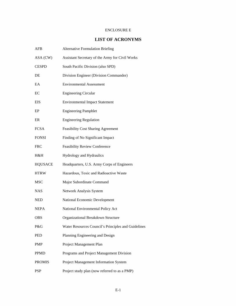
E-1
ENCLOSURE E
LIST OF ACRONYMS
AFB Alternative Formulation Briefing ASA (CW) Assistant Secretary of the Army for Civil Works CESPD South Pacific Division (also SPD) DE Division Engineer (Division Commander) EA Environmental Assessment EC Engineering Circular EIS Environmental Impact Statement EP Engineering Pamphlet ER Engineering Regulation FCSA Feasibility Cost Sharing Agreement FONSI Finding of No Significant Impact FRC Feasibility Review Conference H&H Hydrology and Hydraulics HQUSACE Headquarters, U.S. Army Corps of Engineers HTRW Hazardous, Toxic and Radioactive Waste MSC Major Subordinate Command NAS Network Analysis System NED National Economic Development NEPA National Environmental Policy Act OBS Organizational Breakdown Structure P&G Water Resources Council’s Principles and Guidelines PED Planning Engineering and Design PMP Project Management Plan PPMD Programs and Project Management Division PROMIS Project Management Information System PSP Project study plan (now referred to as a PMP)
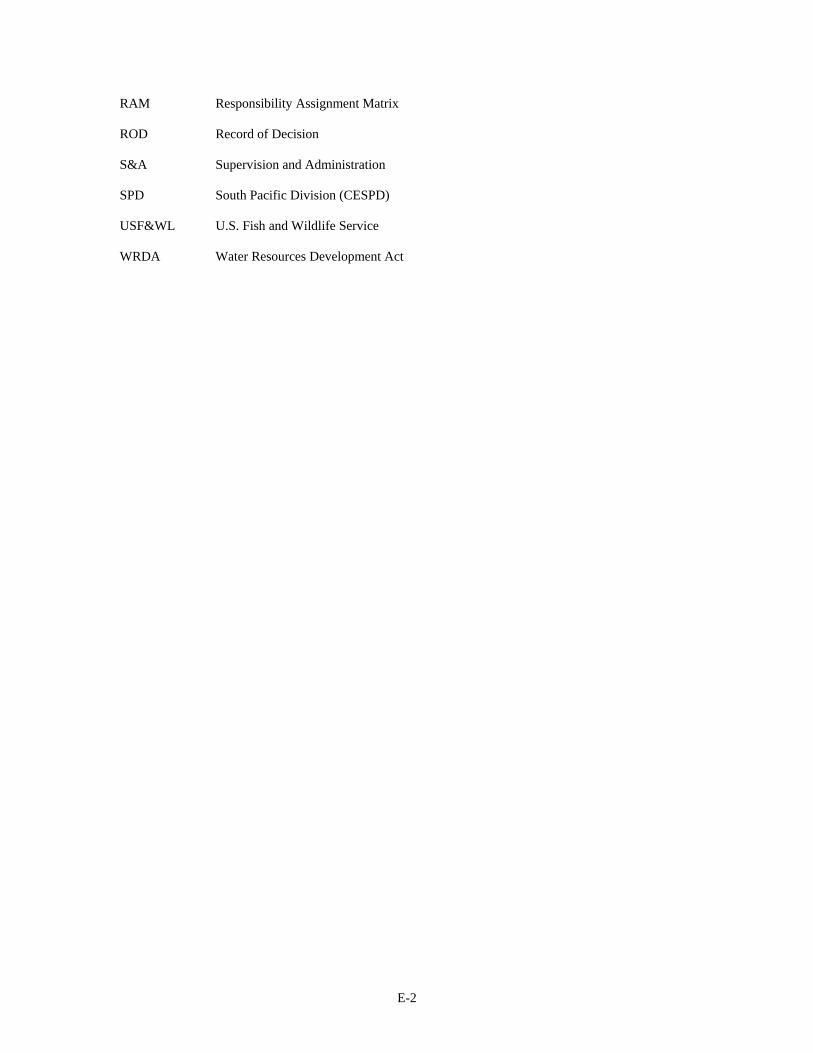
E-2
RAM Responsibility Assignment Matrix ROD Record of Decision S&A Supervision and Administration SPD South Pacific Division (CESPD) USF&WL U.S. Fish and Wildlife Service WRDA Water Resources Development Act

E-3
ENCLOSURE F – SCHEDULE
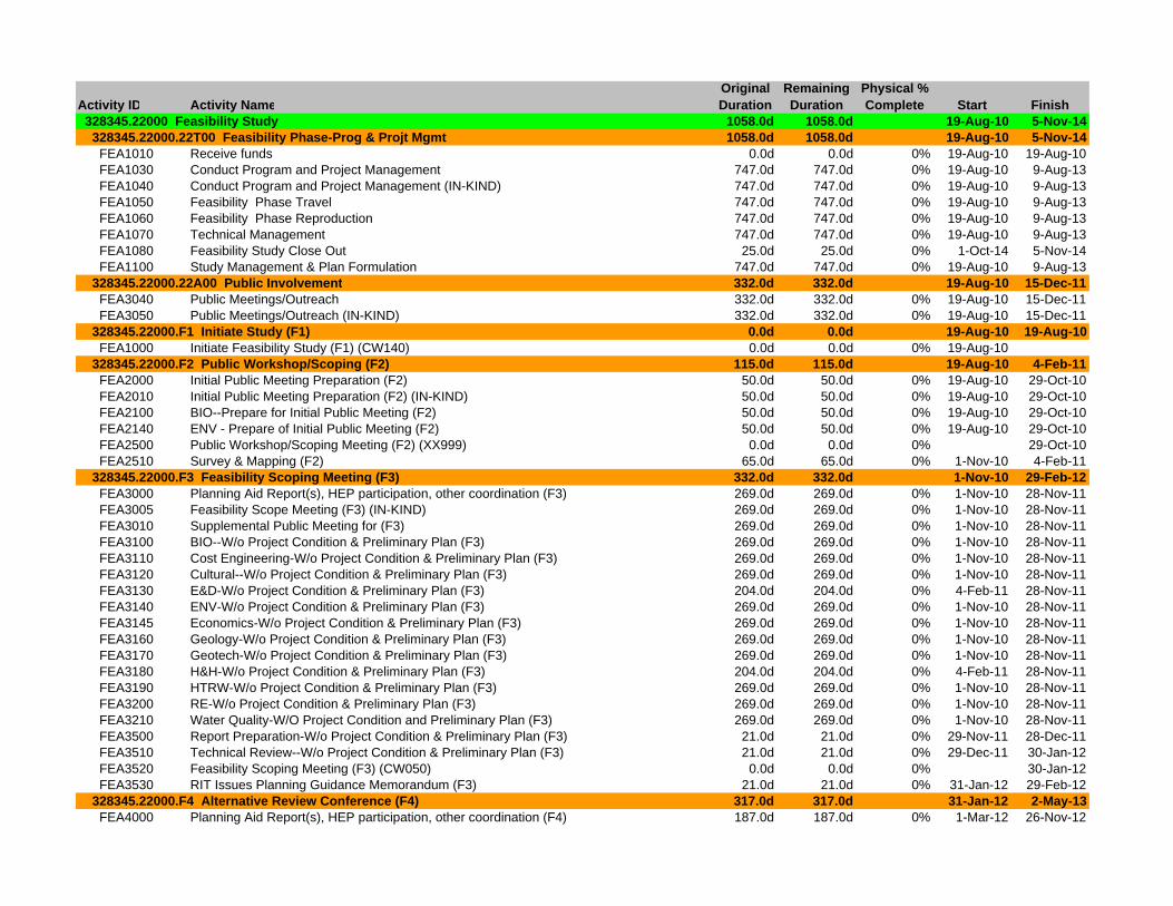
Activity ID Activity NameOriginal Duration
Remaining Duration
Physical % Complete Start Finish
328345.22000 Feasibility Study 1058.0d 1058.0d 19-Aug-10 5-Nov-14 328345.22000.22T00 Feasibility Phase-Prog & Projt Mgmt 1058.0d 1058.0d 19-Aug-10 5-Nov-14 FEA1010 Receive funds 0.0d 0.0d 0% 19-Aug-10 19-Aug-10 FEA1030 Conduct Program and Project Management 747.0d 747.0d 0% 19-Aug-10 9-Aug-13 FEA1040 Conduct Program and Project Management (IN-KIND) 747.0d 747.0d 0% 19-Aug-10 9-Aug-13 FEA1050 Feasibility Phase Travel 747.0d 747.0d 0% 19-Aug-10 9-Aug-13 FEA1060 Feasibility Phase Reproduction 747.0d 747.0d 0% 19-Aug-10 9-Aug-13 FEA1070 Technical Management 747.0d 747.0d 0% 19-Aug-10 9-Aug-13 FEA1080 Feasibility Study Close Out 25.0d 25.0d 0% 1-Oct-14 5-Nov-14 FEA1100 Study Management & Plan Formulation 747.0d 747.0d 0% 19-Aug-10 9-Aug-13 328345.22000.22A00 Public Involvement 332.0d 332.0d 19-Aug-10 15-Dec-11 FEA3040 Public Meetings/Outreach 332.0d 332.0d 0% 19-Aug-10 15-Dec-11 FEA3050 Public Meetings/Outreach (IN-KIND) 332.0d 332.0d 0% 19-Aug-10 15-Dec-11 328345.22000.F1 Initiate Study (F1) 0.0d 0.0d 19-Aug-10 19-Aug-10 FEA1000 Initiate Feasibility Study (F1) (CW140) 0.0d 0.0d 0% 19-Aug-10 328345.22000.F2 Public Workshop/Scoping (F2) 115.0d 115.0d 19-Aug-10 4-Feb-11 FEA2000 Initial Public Meeting Preparation (F2) 50.0d 50.0d 0% 19-Aug-10 29-Oct-10 FEA2010 Initial Public Meeting Preparation (F2) (IN-KIND) 50.0d 50.0d 0% 19-Aug-10 29-Oct-10 FEA2100 BIO--Prepare for Initial Public Meeting (F2) 50.0d 50.0d 0% 19-Aug-10 29-Oct-10 FEA2140 ENV - Prepare of Initial Public Meeting (F2) 50.0d 50.0d 0% 19-Aug-10 29-Oct-10 FEA2500 Public Workshop/Scoping Meeting (F2) (XX999) 0.0d 0.0d 0% 29-Oct-10 FEA2510 Survey & Mapping (F2) 65.0d 65.0d 0% 1-Nov-10 4-Feb-11 328345.22000.F3 Feasibility Scoping Meeting (F3) 332.0d 332.0d 1-Nov-10 29-Feb-12 FEA3000 Planning Aid Report(s), HEP participation, other coordination (F3) 269.0d 269.0d 0% 1-Nov-10 28-Nov-11 FEA3005 Feasibility Scope Meeting (F3) (IN-KIND) 269.0d 269.0d 0% 1-Nov-10 28-Nov-11 FEA3010 Supplemental Public Meeting for (F3) 269.0d 269.0d 0% 1-Nov-10 28-Nov-11 FEA3100 BIO--W/o Project Condition & Preliminary Plan (F3) 269.0d 269.0d 0% 1-Nov-10 28-Nov-11 FEA3110 Cost Engineering-W/o Project Condition & Preliminary Plan (F3) 269.0d 269.0d 0% 1-Nov-10 28-Nov-11 FEA3120 Cultural--W/o Project Condition & Preliminary Plan (F3) 269.0d 269.0d 0% 1-Nov-10 28-Nov-11 FEA3130 E&D-W/o Project Condition & Preliminary Plan (F3) 204.0d 204.0d 0% 4-Feb-11 28-Nov-11 FEA3140 ENV-W/o Project Condition & Preliminary Plan (F3) 269.0d 269.0d 0% 1-Nov-10 28-Nov-11 FEA3145 Economics-W/o Project Condition & Preliminary Plan (F3) 269.0d 269.0d 0% 1-Nov-10 28-Nov-11 FEA3160 Geology-W/o Project Condition & Preliminary Plan (F3) 269.0d 269.0d 0% 1-Nov-10 28-Nov-11 FEA3170 Geotech-W/o Project Condition & Preliminary Plan (F3) 269.0d 269.0d 0% 1-Nov-10 28-Nov-11 FEA3180 H&H-W/o Project Condition & Preliminary Plan (F3) 204.0d 204.0d 0% 4-Feb-11 28-Nov-11 FEA3190 HTRW-W/o Project Condition & Preliminary Plan (F3) 269.0d 269.0d 0% 1-Nov-10 28-Nov-11 FEA3200 RE-W/o Project Condition & Preliminary Plan (F3) 269.0d 269.0d 0% 1-Nov-10 28-Nov-11 FEA3210 Water Quality-W/O Project Condition and Preliminary Plan (F3) 269.0d 269.0d 0% 1-Nov-10 28-Nov-11 FEA3500 Report Preparation-W/o Project Condition & Preliminary Plan (F3) 21.0d 21.0d 0% 29-Nov-11 28-Dec-11 FEA3510 Technical Review--W/o Project Condition & Preliminary Plan (F3) 21.0d 21.0d 0% 29-Dec-11 30-Jan-12 FEA3520 Feasibility Scoping Meeting (F3) (CW050) 0.0d 0.0d 0% 30-Jan-12 FEA3530 RIT Issues Planning Guidance Memorandum (F3) 21.0d 21.0d 0% 31-Jan-12 29-Feb-12 328345.22000.F4 Alternative Review Conference (F4) 317.0d 317.0d 31-Jan-12 2-May-13 FEA4000 Planning Aid Report(s), HEP participation, other coordination (F4) 187.0d 187.0d 0% 1-Mar-12 26-Nov-12
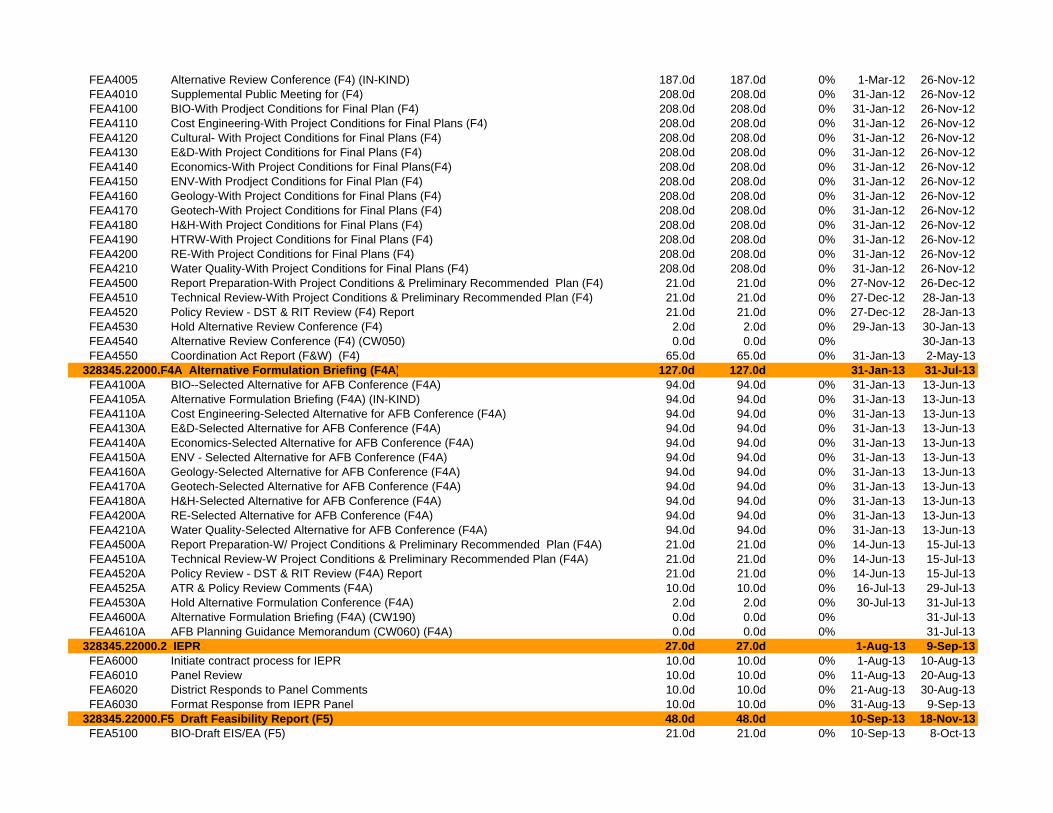
FEA4005 Alternative Review Conference (F4) (IN-KIND) 187.0d 187.0d 0% 1-Mar-12 26-Nov-12 FEA4010 Supplemental Public Meeting for (F4) 208.0d 208.0d 0% 31-Jan-12 26-Nov-12 FEA4100 BIO-With Prodject Conditions for Final Plan (F4) 208.0d 208.0d 0% 31-Jan-12 26-Nov-12 FEA4110 Cost Engineering-With Project Conditions for Final Plans (F4) 208.0d 208.0d 0% 31-Jan-12 26-Nov-12 FEA4120 Cultural- With Project Conditions for Final Plans (F4) 208.0d 208.0d 0% 31-Jan-12 26-Nov-12 FEA4130 E&D-With Project Conditions for Final Plans (F4) 208.0d 208.0d 0% 31-Jan-12 26-Nov-12 FEA4140 Economics-With Project Conditions for Final Plans(F4) 208.0d 208.0d 0% 31-Jan-12 26-Nov-12 FEA4150 ENV-With Prodject Conditions for Final Plan (F4) 208.0d 208.0d 0% 31-Jan-12 26-Nov-12 FEA4160 Geology-With Project Conditions for Final Plans (F4) 208.0d 208.0d 0% 31-Jan-12 26-Nov-12 FEA4170 Geotech-With Project Conditions for Final Plans (F4) 208.0d 208.0d 0% 31-Jan-12 26-Nov-12 FEA4180 H&H-With Project Conditions for Final Plans (F4) 208.0d 208.0d 0% 31-Jan-12 26-Nov-12 FEA4190 HTRW-With Project Conditions for Final Plans (F4) 208.0d 208.0d 0% 31-Jan-12 26-Nov-12 FEA4200 RE-With Project Conditions for Final Plans (F4) 208.0d 208.0d 0% 31-Jan-12 26-Nov-12 FEA4210 Water Quality-With Project Conditions for Final Plans (F4) 208.0d 208.0d 0% 31-Jan-12 26-Nov-12 FEA4500 Report Preparation-With Project Conditions & Preliminary Recommended Plan (F4) 21.0d 21.0d 0% 27-Nov-12 26-Dec-12 FEA4510 Technical Review-With Project Conditions & Preliminary Recommended Plan (F4) 21.0d 21.0d 0% 27-Dec-12 28-Jan-13 FEA4520 Policy Review - DST & RIT Review (F4) Report 21.0d 21.0d 0% 27-Dec-12 28-Jan-13 FEA4530 Hold Alternative Review Conference (F4) 2.0d 2.0d 0% 29-Jan-13 30-Jan-13 FEA4540 Alternative Review Conference (F4) (CW050) 0.0d 0.0d 0% 30-Jan-13 FEA4550 Coordination Act Report (F&W) (F4) 65.0d 65.0d 0% 31-Jan-13 2-May-13 328345.22000.F4A Alternative Formulation Briefing (F4A) 127.0d 127.0d 31-Jan-13 31-Jul-13 FEA4100A BIO--Selected Alternative for AFB Conference (F4A) 94.0d 94.0d 0% 31-Jan-13 13-Jun-13 FEA4105A Alternative Formulation Briefing (F4A) (IN-KIND) 94.0d 94.0d 0% 31-Jan-13 13-Jun-13 FEA4110A Cost Engineering-Selected Alternative for AFB Conference (F4A) 94.0d 94.0d 0% 31-Jan-13 13-Jun-13 FEA4130A E&D-Selected Alternative for AFB Conference (F4A) 94.0d 94.0d 0% 31-Jan-13 13-Jun-13 FEA4140A Economics-Selected Alternative for AFB Conference (F4A) 94.0d 94.0d 0% 31-Jan-13 13-Jun-13 FEA4150A ENV - Selected Alternative for AFB Conference (F4A) 94.0d 94.0d 0% 31-Jan-13 13-Jun-13 FEA4160A Geology-Selected Alternative for AFB Conference (F4A) 94.0d 94.0d 0% 31-Jan-13 13-Jun-13 FEA4170A Geotech-Selected Alternative for AFB Conference (F4A) 94.0d 94.0d 0% 31-Jan-13 13-Jun-13 FEA4180A H&H-Selected Alternative for AFB Conference (F4A) 94.0d 94.0d 0% 31-Jan-13 13-Jun-13 FEA4200A RE-Selected Alternative for AFB Conference (F4A) 94.0d 94.0d 0% 31-Jan-13 13-Jun-13 FEA4210A Water Quality-Selected Alternative for AFB Conference (F4A) 94.0d 94.0d 0% 31-Jan-13 13-Jun-13 FEA4500A Report Preparation-W/ Project Conditions & Preliminary Recommended Plan (F4A) 21.0d 21.0d 0% 14-Jun-13 15-Jul-13 FEA4510A Technical Review-W Project Conditions & Preliminary Recommended Plan (F4A) 21.0d 21.0d 0% 14-Jun-13 15-Jul-13 FEA4520A Policy Review - DST & RIT Review (F4A) Report 21.0d 21.0d 0% 14-Jun-13 15-Jul-13 FEA4525A ATR & Policy Review Comments (F4A) 10.0d 10.0d 0% 16-Jul-13 29-Jul-13 FEA4530A Hold Alternative Formulation Conference (F4A) 2.0d 2.0d 0% 30-Jul-13 31-Jul-13 FEA4600A Alternative Formulation Briefing (F4A) (CW190) 0.0d 0.0d 0% 31-Jul-13 FEA4610A AFB Planning Guidance Memorandum (CW060) (F4A) 0.0d 0.0d 0% 31-Jul-13 328345.22000.2 IEPR 27.0d 27.0d 1-Aug-13 9-Sep-13 FEA6000 Initiate contract process for IEPR 10.0d 10.0d 0% 1-Aug-13 10-Aug-13 FEA6010 Panel Review 10.0d 10.0d 0% 11-Aug-13 20-Aug-13 FEA6020 District Responds to Panel Comments 10.0d 10.0d 0% 21-Aug-13 30-Aug-13 FEA6030 Format Response from IEPR Panel 10.0d 10.0d 0% 31-Aug-13 9-Sep-13 328345.22000.F5 Draft Feasibility Report (F5) 48.0d 48.0d 10-Sep-13 18-Nov-13 FEA5100 BIO-Draft EIS/EA (F5) 21.0d 21.0d 0% 10-Sep-13 8-Oct-13
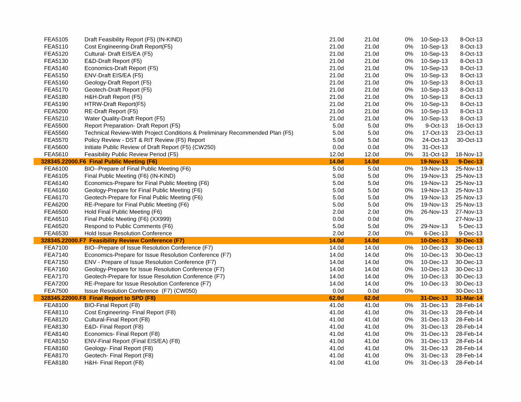
FEA5105 Draft Feasibility Report (F5) (IN-KIND) 21.0d 21.0d 0% 10-Sep-13 8-Oct-13 FEA5110 Cost Engineering-Draft Report(F5) 21.0d 21.0d 0% 10-Sep-13 8-Oct-13 FEA5120 Cultural- Draft EIS/EA (F5) 21.0d 21.0d 0% 10-Sep-13 8-Oct-13 FEA5130 E&D-Draft Report (F5) 21.0d 21.0d 0% 10-Sep-13 8-Oct-13 FEA5140 Economics-Draft Report (F5) 21.0d 21.0d 0% 10-Sep-13 8-Oct-13 FEA5150 ENV-Draft EIS/EA (F5) 21.0d 21.0d 0% 10-Sep-13 8-Oct-13 FEA5160 Geology-Draft Report (F5) 21.0d 21.0d 0% 10-Sep-13 8-Oct-13 FEA5170 Geotech-Draft Report (F5) 21.0d 21.0d 0% 10-Sep-13 8-Oct-13 FEA5180 H&H-Draft Report (F5) 21.0d 21.0d 0% 10-Sep-13 8-Oct-13 FEA5190 HTRW-Draft Report(F5) 21.0d 21.0d 0% 10-Sep-13 8-Oct-13 FEA5200 RE-Draft Report (F5) 21.0d 21.0d 0% 10-Sep-13 8-Oct-13 FEA5210 Water Quality-Draft Report (F5) 21.0d 21.0d 0% 10-Sep-13 8-Oct-13 FEA5500 Report Preparation- Draft Report (F5) 5.0d 5.0d 0% 9-Oct-13 16-Oct-13 FEA5560 Technical Review-With Project Conditions & Preliminary Recommended Plan (F5) 5.0d 5.0d 0% 17-Oct-13 23-Oct-13 FEA5570 Policy Review - DST & RIT Review (F5) Report 5.0d 5.0d 0% 24-Oct-13 30-Oct-13 FEA5600 Initiate Public Review of Draft Report (F5) (CW250) 0.0d 0.0d 0% 31-Oct-13 FEA5610 Feasibility Public Review Period (F5) 12.0d 12.0d 0% 31-Oct-13 18-Nov-13 328345.22000.F6 Final Public Meeting (F6) 14.0d 14.0d 19-Nov-13 9-Dec-13 FEA6100 BIO--Prepare of Final Public Meeting (F6) 5.0d 5.0d 0% 19-Nov-13 25-Nov-13 FEA6105 Final Public Meeting (F6) (IN-KIND) 5.0d 5.0d 0% 19-Nov-13 25-Nov-13 FEA6140 Economics-Prepare for Final Public Meeting (F6) 5.0d 5.0d 0% 19-Nov-13 25-Nov-13 FEA6160 Geology-Prepare for Final Public Meeting (F6) 5.0d 5.0d 0% 19-Nov-13 25-Nov-13 FEA6170 Geotech-Prepare for Final Public Meeting (F6) 5.0d 5.0d 0% 19-Nov-13 25-Nov-13 FEA6200 RE-Prepare for Final Public Meeting (F6) 5.0d 5.0d 0% 19-Nov-13 25-Nov-13 FEA6500 Hold Final Public Meeting (F6) 2.0d 2.0d 0% 26-Nov-13 27-Nov-13 FEA6510 Final Public Meeting (F6) (XX999) 0.0d 0.0d 0% 27-Nov-13 FEA6520 Respond to Public Comments (F6) 5.0d 5.0d 0% 29-Nov-13 5-Dec-13 FEA6530 Hold Issue Resolution Conference 2.0d 2.0d 0% 6-Dec-13 9-Dec-13 328345.22000.F7 Feasibility Review Conference (F7) 14.0d 14.0d 10-Dec-13 30-Dec-13 FEA7100 BIO--Prepare of Issue Resolution Conference (F7) 14.0d 14.0d 0% 10-Dec-13 30-Dec-13 FEA7140 Economics-Prepare for Issue Resolution Conference (F7) 14.0d 14.0d 0% 10-Dec-13 30-Dec-13 FEA7150 ENV - Prepare of Issue Resolution Conference (F7) 14.0d 14.0d 0% 10-Dec-13 30-Dec-13 FEA7160 Geology-Prepare for Issue Resolution Conference (F7) 14.0d 14.0d 0% 10-Dec-13 30-Dec-13 FEA7170 Geotech-Prepare for Issue Resolution Conference (F7) 14.0d 14.0d 0% 10-Dec-13 30-Dec-13 FEA7200 RE-Prepare for Issue Resolution Conference (F7) 14.0d 14.0d 0% 10-Dec-13 30-Dec-13 FEA7500 Issue Resolution Conference (F7) (CW050) 0.0d 0.0d 0% 30-Dec-13 328345.22000.F8 Final Report to SPD (F8) 62.0d 62.0d 31-Dec-13 31-Mar-14 FEA8100 BIO-Final Report (F8) 41.0d 41.0d 0% 31-Dec-13 28-Feb-14 FEA8110 Cost Engineering- Final Report (F8) 41.0d 41.0d 0% 31-Dec-13 28-Feb-14 FEA8120 Cultural-Final Report (F8) 41.0d 41.0d 0% 31-Dec-13 28-Feb-14 FEA8130 E&D- Final Report (F8) 41.0d 41.0d 0% 31-Dec-13 28-Feb-14 FEA8140 Economics- Final Report (F8) 41.0d 41.0d 0% 31-Dec-13 28-Feb-14 FEA8150 ENV-Final Report (Final EIS/EA) (F8) 41.0d 41.0d 0% 31-Dec-13 28-Feb-14 FEA8160 Geology- Final Report (F8) 41.0d 41.0d 0% 31-Dec-13 28-Feb-14 FEA8170 Geotech- Final Report (F8) 41.0d 41.0d 0% 31-Dec-13 28-Feb-14 FEA8180 H&H- Final Report (F8) 41.0d 41.0d 0% 31-Dec-13 28-Feb-14