Embed Size (px)
Citation preview

U.S. Department of the Interior 1
Landsat Data Continuity Mission OverviewLandsat Data Continuity Mission Overview
Landsat Ground StationSioux Falls, SD
Representative ICCanada
Gilmore Creek Ground StationFairbanks, AK
TDRSS
Atlas VVAFB
LDCM Orbit705 km circular
sun sync, 10am DNLT16-day repeat
NASA NENWallops Island, VA
LDCM Observatory(OLI, TIRS)
Launch Readiness Date: February 11, 2013
Svalbard Ground StationSvalbard, Norway
U.S. Department of the Interior 2
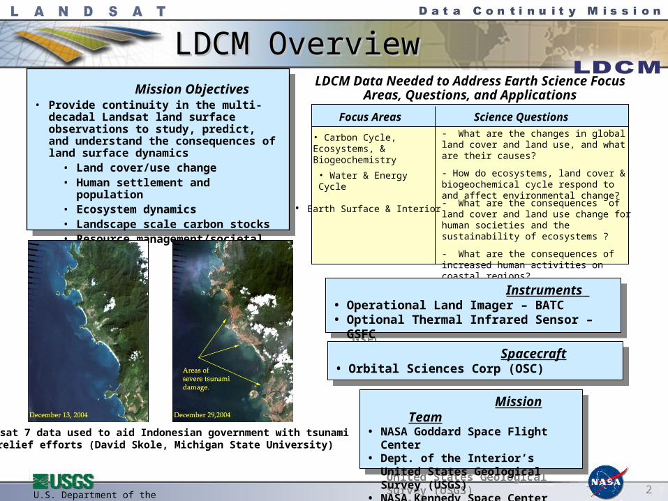
LDCM OverviewLDCM Overview Mission Objectives
• Provide continuity in the multi-decadal Landsat land surface observations to study, predict, and understand the consequences of land surface dynamics
• Land cover/use change• Human settlement and population• Ecosystem dynamics• Landscape scale carbon stocks• Resource management/societal needs
LDCM Data Needed to Address Earth Science Focus Areas, Questions, and Applications
• Carbon Cycle, Ecosystems, & Biogeochemistry
• Water & Energy Cycle
- What are the changes in global land cover and land use, and what are their causes?
- How do ecosystems, land cover & biogeochemical cycle respond to and affect environmental change?
- What are the consequences of land cover and land use change for human societies and the sustainability of ecosystems ?
- What are the consequences of increased human activities on coastal regions?
Focus Areas Science Questions
• Earth Surface & Interior
Landsat 7 data used to aid Indonesian government with tsunami relief efforts (David Skole, Michigan State University)
Mission Team• NASA Goddard Space Flight Center• Dept. of the Interior’s United States
Geological Survey (USGS)• NASA Kennedy Space Center
Mission Team• NASA Goddard Space Flight Center• Dept. of the Interior’s United States
Geological Survey (USGS)• NASA Kennedy Space Center
Instruments • Operational Land Imager – BATC• Optional Thermal Infrared Sensor – GSFC
Instruments • Operational Land Imager – BATC• Optional Thermal Infrared Sensor – GSFC
Spacecraft• Orbital Sciences Corp (OSC)
Spacecraft• Orbital Sciences Corp (OSC)
U.S. Department of the Interior 3
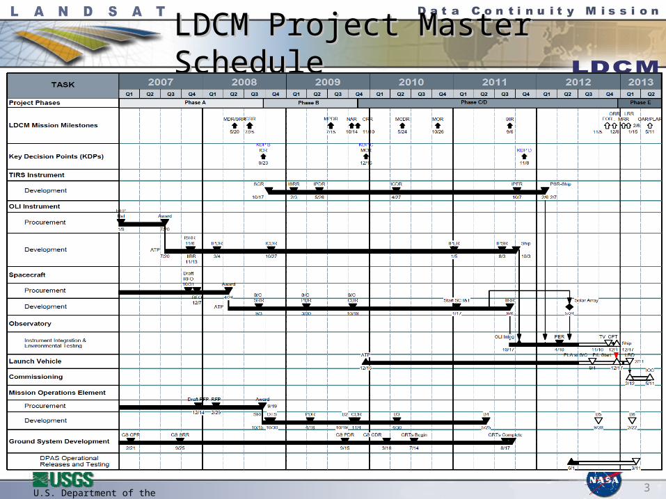
LDCM Project Master ScheduleLDCM Project Master Schedule

U.S. Department of the Interior 4
Day 1 15 30 6045Launch thru Deployment Sep, Bus Init, ACS Acq, SA Deploy
Subsystem Initialization EPS, ACS, TCS, C&DH, RF Comm
ACS Calibration
TIRS Activation - power on and dryout, cryocooler deploy
OLI Activation -Electronics & Htrs On, Shutter, Dryout
OLI Activation – FPA Cooldown
Launch
75
OLI Characterization and Commissioning
90
Orbit Maneuvers, ascent burns
TIRS Activation – cooldown and Diagnostics check
Deploy Earth shield
TIRS Characterization and Commissioning
Close shutter
LDCM Post-launch CheckoutLDCM Post-launch Checkout
U.S. Department of the Interior 5
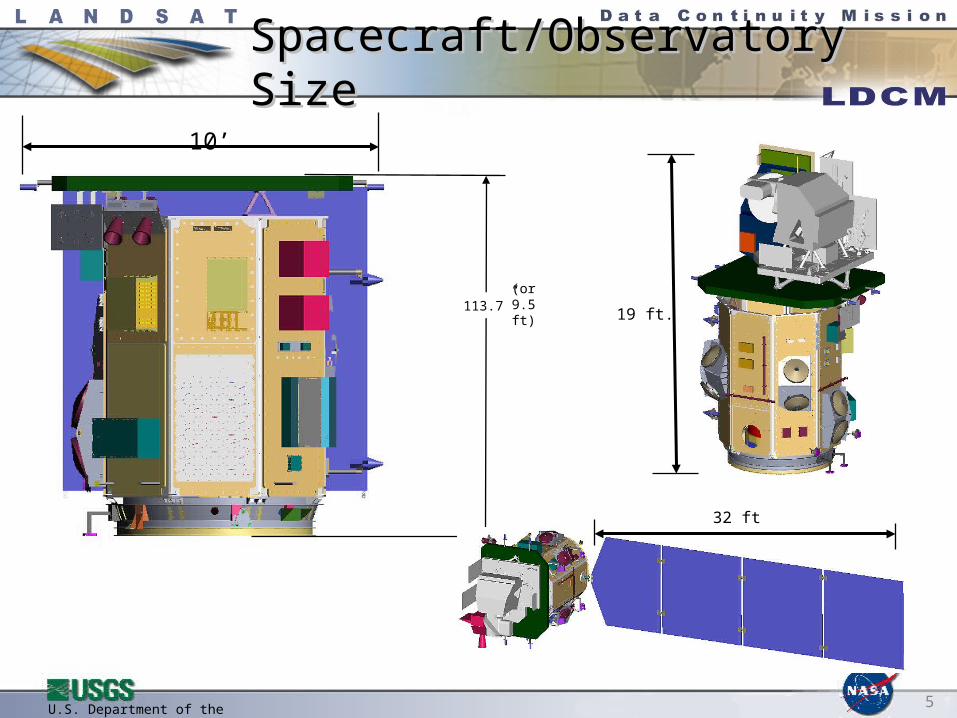
Spacecraft/Observatory SizeSpacecraft/Observatory Size
113.7”(or 9.5 ft)
10’
32 ft
19 ft.
U.S. Department of the Interior 6
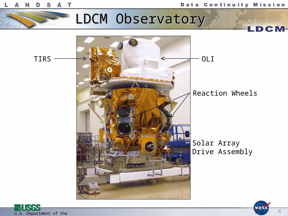
LDCM ObservatoryLDCM Observatory
OLITIRS
Solar ArrayDrive Assembly
Reaction Wheels
U.S. Department of the Interior 7
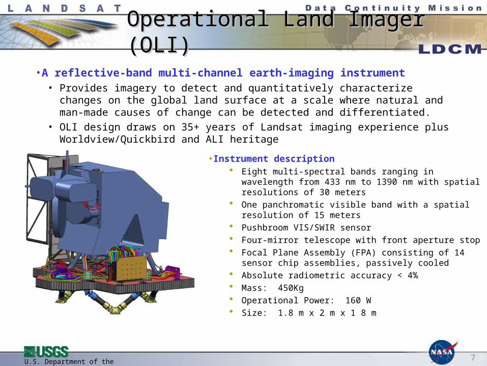
Operational Land Imager (OLI)Operational Land Imager (OLI)
• Instrument description Eight multi-spectral bands ranging in wavelength from
433 nm to 1390 nm with spatial resolutions of 30 meters One panchromatic visible band with a spatial resolution
of 15 meters Pushbroom VIS/SWIR sensor Four-mirror telescope with front aperture stop Focal Plane Assembly (FPA) consisting of 14 sensor
chip assemblies, passively cooled Absolute radiometric accuracy < 4% Mass: 450Kg Operational Power: 160 W Size: 1.8 m x 2 m x 1 8 m
• A reflective-band multi-channel earth-imaging instrument • Provides imagery to detect and quantitatively characterize changes on the global land
surface at a scale where natural and man-made causes of change can be detected and differentiated.
• OLI design draws on 35+ years of Landsat imaging experience plus Worldview/Quickbird and ALI heritage
U.S. Department of the Interior 8
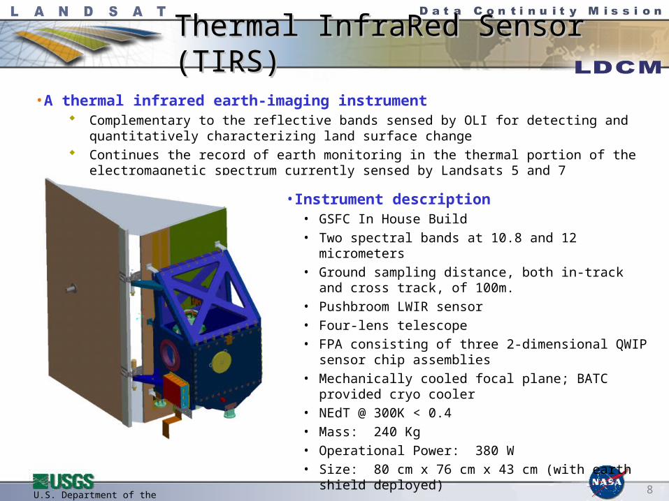
Thermal InfraRed Sensor (TIRS)Thermal InfraRed Sensor (TIRS)
• A thermal infrared earth-imaging instrument Complementary to the reflective bands sensed by OLI for detecting and quantitatively
characterizing land surface change Continues the record of earth monitoring in the thermal portion of the electromagnetic spectrum
currently sensed by Landsats 5 and 7
• Instrument description• GSFC In House Build• Two spectral bands at 10.8 and 12 micrometers • Ground sampling distance, both in-track and cross track,
of 100m. • Pushbroom LWIR sensor • Four-lens telescope• FPA consisting of three 2-dimensional QWIP sensor chip
assemblies• Mechanically cooled focal plane; BATC provided cryo
cooler• NEdT @ 300K < 0.4• Mass: 240 Kg• Operational Power: 380 W• Size: 80 cm x 76 cm x 43 cm (with earth shield
deployed)
U.S. Department of the Interior 9
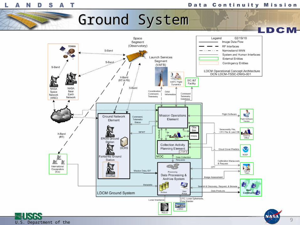
Ground SystemGround System

U.S. Department of the Interior 10
Operational Land Imager BandsOperational Land Imager Bands
U.S. Department of the Interior 11
New LDCM Capabilities New LDCM Capabilities Spectral band improvements
Landsat 7 offered 8 spectral bands (3 VIS, 1 NIR, 2 SWIR, 1 TIR, and pan band) LDCM has 11 spectral bands (4 VIS, 1 NIR, 3 SWIR, 2 TIR, and a pan band)
• New VIS “coastal aerosol” band allows detection of water column constituents (e.g., chlorophyll, suspended materials, etc.)
• New SWIR “cirrus” band will improve overall image quality because of better cloud screening
• Addition of a 2nd thermal band will improve the accuracy and precision of temperature measurements. Note, however, that TIR resolution decreases from 60m to 100m.
• Changes in panchromatic band spectral range will increase the overall use of this band for image sharpening and other applications.
Detection, quantification, and mapping of surface (land and water) characteristics will improve because of: 5x improvement of signal-to-noise ratios of spectral measurements 12 bit quantization of spectral signals (Landsat 7 was 8 bit)
Limited off-nadir imaging capability will allow viewing adjacent path rows.

U.S. Department of the Interior 12
T-150 days and counting…
LDCM is almost ready for launch!!