Embed Size (px)
Citation preview
U.S. Fish & Wildlife Service
WETLAND MAPPING & CLASSIFICATION
National Wetlands Inventory Southwest Region

U.S. Fish & Wildlife Service
Program Vision
The National Wetlands Inventory (NWI) provides scientifically-based information on the location, status, extent, characteristics, and functions of
wetlands and related habitats to promote the understanding and conservation of these resources.
Bosque del Apache NWR

U.S. Fish & Wildlife Service
Program Mission The NWI program supports National and Service policies and initiatives to further conservation of the Nation’s wetlands and related habitats by; 1. Producing, maintaining, and providing current and historical geospatial
wetland data and information for the Nation.
2. Analyzing and reporting on status and trends where wetlands and related habitats are vulnerable to change, loss or degradation, either man made or natural. 3. Promoting sound decision making and policy formation, through the development and dissemination of wetlands data and information through a variety of media.

U.S. Fish & Wildlife Service
The National Wetlands Inventory was established in 1974. In 1986 The Emergency Wetlands Resources Act (P.L. 99-645) directed the USFWS to complete mapping of the Conterminous United States and Alaska. The Cowardin Classification System used by the USFWS to describe wetland habitats is now the National Standard for any federally-based wetland mapping. The Presidential; Office of Management and Budget (OMB) Circular A-16 states the USFWS is responsible for maintaining the wetlands data layer of the National Spatial Data Infrastructure (NSDI).
NWI: A National Program,
Setting Standards

U.S. Fish & Wildlife Service
1970’s: Wetlands photo interpretation done on 1:120,000 and 1:80,000 B&W aerial photography. Wetlands coded out to Class only. Wetland delineations manually rectified to USGS topo base with Zoom Transfer Scope. 1980’s: Wetlands photo interpretation done on 1:58,000 and 1:40,000 CIR aerial photography. Wetlands coded to full extent of class system. Transfer rectification still done manually. Status and Trends work begins. Large-scale production of NWI maps ensues. 1990’s: Various scales and types of aerial photos are used as project areas become more focused, due to budget cuts and loss of primary contractor. Large-scale vectorization of NWI maps begins. Early attempts at digital map creation take place. 2000’s: “Pen & ink” era of NWI map creation ends. All data is created digitally, in a head’s-up or Digital Transfer Scope environment. NWI partners with USGS to create a Wetlands Master Geodatabase and web interface. National data standards are created for all digital NWI data. 2010’s: The onset of contributed and “scalable” data lead to near total completion of national wetlands dataset. EPA State and Tribal wetland programs account for much the this data inflow. Look for “NWI 2.0”.
Program History

U.S. Fish & Wildlife Service
Data Limitations The Service's objective of mapping wetlands and deepwater habitats is to produce reconnaissance level information on the location, type and size of these resources. The maps are prepared from the analysis of high altitude imagery. Wetlands are identified based on vegetation, visible hydrology and geography. A margin of error is inherent in the use of imagery; thus, detailed on-the-ground inspection of any particular site may result in revision of the wetland boundaries or classification established through image analysis.
Precautions - Federal, state, and local regulatory agencies with jurisdiction over wetlands may define and describe wetlands in a different manner than that used in this inventory. There is no attempt, in either the design or products of this inventory, to define the limits of proprietary jurisdiction of any Federal, state, or local government or to establish the geographical scope of the regulatory programs of government agencies. Persons intending to engage in activities involving modifications within or adjacent to wetland areas should seek the advice of appropriate federal, state, or local agencies concerning specified agency regulatory programs and proprietary jurisdictions that may affect such activities.

U.S. Fish & Wildlife Service
What is a Wetland?
The Service uses the Cowardin et al. (1979) definition of a wetland; Classification of Wetlands and Deepwater Habitats of the United States (FWS/OBS – 79/31 December 1979). This definition is the Federal standard for classifying and mapping wetlands as determined by the Federal Geographic Data Committee. It is a two-part definition as indicated below: Wetlands are lands transitional between terrestrial and aquatic systems where the water table is usually at or near the surface or the land is covered by shallow water. For purposes of this classification wetlands must have one or more of the following three attributes: 1) at least periodically, the land supports predominantly hydrophytes; 2) the substrate is predominantly undrained hydric soil; and 3) the substrate is nonsoil and is saturated with water or covered by shallow water at some time during the growing season of each year.

U.S. Fish & Wildlife Service
Are Wetlands Important?
• Maintain Natural Fish/Wildlife Habitat • Flood Control/Retention • Promote Nutrient Transformation • Carbon Sequestration • Stream Bank Maintenance • Water Quality • Aquifer Recharge (other areas) • Education/Recreation
One part of a bigger picture of ecosystem health… relating directly to human health.

U.S. Fish & Wildlife Service
Why Map Wetlands?
Create a current spatial inventory of wetland habitats; • Location • Area • Structure and Composition
Set a baseline for trend studies, future and past;
• Human Development • Climate Change/Natural Variations • Restoration & Re-establishment

U.S. Fish & Wildlife Service
Why Map Wetlands?
Wetlands Hydrography Land Cover Elevation Jurisdiction Etc…
One tool, in the toolbox of data and information systems to aid in making sound, scientific decisions.

U.S. Fish & Wildlife Service
Mapping Wetlands… The NWI Way!
U.S. Fish & Wildlife Service
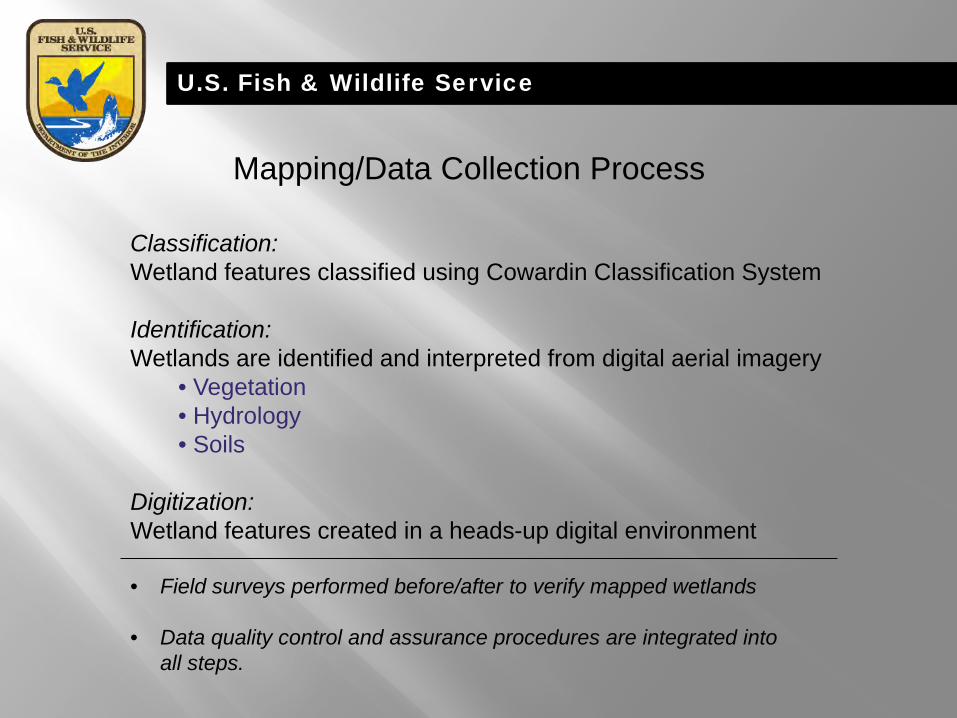
Classification: Wetland features classified using Cowardin Classification System Identification: Wetlands are identified and interpreted from digital aerial imagery
• Vegetation • Hydrology • Soils
Digitization: Wetland features created in a heads-up digital environment • Field surveys performed before/after to verify mapped wetlands
• Data quality control and assurance procedures are integrated into all steps.
Mapping/Data Collection Process

U.S. Fish & Wildlife Service
Mapping/Data Collection Process: Classification Cowardin Classification System for Mapping Wetlands
Hierarchal (L1UBHh) System (L)
Subsystem (1)
Class (UB)
Subclass (-)
Water Regime (H)
Special Modifiers (h)

U.S. Fish & Wildlife Service
Mapping/Data Collection Process: Classification Cowardin Classification System for Mapping Wetlands

U.S. Fish & Wildlife Service
Mapping/Data Collection Process: Classification Cowardin Classification System for Mapping Wetlands
U.S. Fish & Wildlife Service
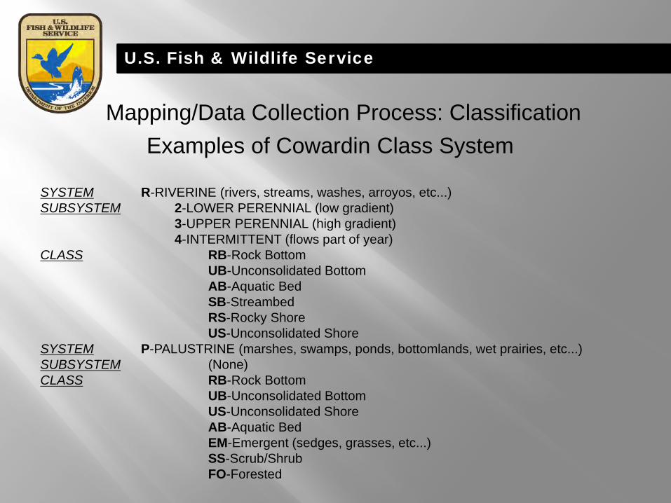
SYSTEM R-RIVERINE (rivers, streams, washes, arroyos, etc...) SUBSYSTEM 2-LOWER PERENNIAL (low gradient) 3-UPPER PERENNIAL (high gradient) 4-INTERMITTENT (flows part of year) CLASS RB-Rock Bottom UB-Unconsolidated Bottom AB-Aquatic Bed SB-Streambed RS-Rocky Shore US-Unconsolidated Shore SYSTEM P-PALUSTRINE (marshes, swamps, ponds, bottomlands, wet prairies, etc...) SUBSYSTEM (None) CLASS RB-Rock Bottom UB-Unconsolidated Bottom US-Unconsolidated Shore AB-Aquatic Bed EM-Emergent (sedges, grasses, etc...) SS-Scrub/Shrub FO-Forested
Examples of Cowardin Class System Mapping/Data Collection Process: Classification

U.S. Fish & Wildlife Service
CLASS SS-Scrub/Shrub and FO-Forested SUBCLASS 1 Broad-leaved Deciduous (ex. willow, cottonwood) 2 Needle-leaved Deciduous (ex. Salt cedar) 3 Broad-leaved Evergreen 4 Needle-leaved Evergreen 5 Dead 6 Deciduous 7 Evergreen
Examples of Cowardin Class System, Cont.
MODIFIERS WATER REGIME A Temporarily Flooded B Saturated C Seasonally Flooded E Seasonally Flooded/Saturated F Semi-permanently Flooded H Permanently Flooded J Intermittently Flooded K Artificially Flooded SPECIAL MODIFIERS b Beaver d Partially drained/Ditched f Farmed h Diked/Impounded x Excavated
Mapping/Data Collection Process: Classification

U.S. Fish & Wildlife Service
Generalized Wetland Structure, Relating to Classification Mapping/Data Collection Process: Classification

U.S. Fish & Wildlife Service
Mapping/Data Collection Process: Identification & Digitization
In order to assure wetlands are accurately interpreted and identified, ancillary datasets are used to derive needed information; • Hydrology/Topology (NHD, DRG’s, LiDAR) • Soils (SSURGO)
Field surveys are conducted, before and after, the mapping process to verify wetland type and classification. Wetland features are digitized using Esri, inc. ArcGIS, Geodatabase format. Polygonal and linear shapes are used to define wetland areas.
Digital aerial imagery (publicly available) is used as a base for all wetland mapping.

U.S. Fish & Wildlife Service
True color aerial image.

U.S. Fish & Wildlife Service
Field surveys are conducted to verify photo signatures.

U.S. Fish & Wildlife Service
Wetland features digitized, using Esri, Inc. ArcGIS.
U.S. Fish & Wildlife Service
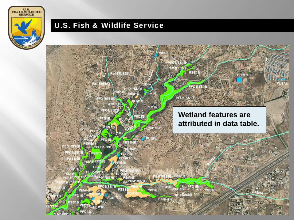
Wetland features are attributed in data table.

U.S. Fish & Wildlife Service
Overview of wetland geospatial data (polygon and linear features).

U.S. Fish & Wildlife Service
Wetland Code Generalized Wetland Habitat Type Basic Hydrology Flooding Duration Man-Impact PEM1/SS1E Freshwater Emergent/Shrub Wetland Groundwater & Surface Flooding Saturated & Seasonal/Drainage PEM1/SS1J Freshwater Emergent/Shrub Wetland Surface Flooding Intermittent PEM1Ah Freshwater Emergent Wetland Surface Flooding Temporary PEM1B Freshwater Emergent Wetland Groundwater Saturated/Slope PEM1Cx Freshwater Emergent Wetland Surface Flooding Seasonal Excavated PEM1E Freshwater Emergent Wetland Groundwater & Surface Flooding Saturated & Seasonal/Drainage PEM1Eh Freshwater Emergent Wetland Groundwater & Surface Flooding Saturated & Seasonal/Drainage Impounded PEM1J Freshwater Emergent Wetland Surface Flooding Intermittent PEM1Jh Freshwater Emergent Wetland Surface Flooding Intermittent Impounded PFO1/4B Freshwater Forested Wetland Groundwater Saturated/Slope PFO1/EM1B Freshwater Forested/Shrub Wetland Groundwater Saturated/Slope PFO1/SS1E Freshwater Forested/Shrub Wetland Groundwater & Surface Flooding Saturated & Seasonal/Drainage PFO1/SS2C Freshwater Forested/Shrub Wetland Surface Flooding Seasonal PFO1B Freshwater Forested/Shrub Wetland Groundwater Saturated/Slope PFO1E Freshwater Forested/Shrub Wetland Groundwater & Surface Flooding Saturated & Seasonal/Drainage PFO1J Freshwater Forested/Shrub Wetland Surface Flooding Intermittent PSS1/2C Freshwater Forested/Shrub Wetland Surface Flooding Seasonal PSS1/4B Freshwater Forested/Shrub Wetland Groundwater Saturated/Slope PSS1B Freshwater Forested/Shrub Wetland Groundwater Saturated/Slope PSS1Cx Freshwater Forested/Shrub Wetland Surface Flooding Seasonal Excavated PSS1E Freshwater Forested/Shrub Wetland Groundwater & Surface Flooding Saturated & Seasonal/Drainage PUBHh Freshwater Pond Surface Flooding Permanent Impounded PUBHx Freshwater Pond Surface Flooding Permanent Excavated PUBKx Freshwater Pond Surface Flooding Artificial Excavated PUSCx Freshwater Pond Surface Flooding Seasonal Excavated PUSJh Freshwater Pond Surface Flooding Intermittent Impounded R2UBH Riverine Surface Flooding Permanent R4SBA Riverine Surface Flooding Temporary R4SBC Riverine Surface Flooding Seasonal R4SBJ Riverine Surface Flooding Intermittent
Describing Wetland Habitats

U.S. Fish & Wildlife Service
Intermittent streambed with forested wetland (R4SBJ & PFO1J).
Emergent & scrub-shrub wetland (PEM1F & PSS1C).
Wetland Examples;

U.S. Fish & Wildlife Service
Emergent wetland, former river channel (PEM1F).
Impounded pond, with adjacent emergent Wetlands (PUBHh & PEM1Fh).
Wetland Examples;

U.S. Fish & Wildlife Service
Types of NWI Wetlands Data Standard Wetlands Digital Data (Vector) •Meets FGDC National Standards •Photo interpreted, detailed mapping (0.1 acre) Scanned Raster (from hardcopies) •Scanned from original map mylar or photo overlay •Rough geo-referencing •Labels, leader lines, corner tic marks included
Hardcopy Only (1:24,000 scale) Scalable Mapping Landscape-level approach (small scale) “Generalized” wetlands mapping Truncated class system Assembled from various data sources May not meet National Map Standards

U.S. Fish & Wildlife Service
Types of NWI Wetlands Data
9/30/12

U.S. Fish & Wildlife Service
Scalable and Contributed Wetlands Data: “Filling in the Gaps”
Issues currently being faced by NWI/USFWS: • Reduced Budgets • Reduced Manpower • Shifting Priorities • Wetland Data Gaps • Need for Landscape-level Data (LCC Support) • Need to Cover Large Areas… Quickly!

U.S. Fish & Wildlife Service
Scalable Wetlands Data: “Filling in the Gaps”
Scalable to ‘fill-in’ data gaps provide less detailed information
Scalable maps are considered an interim product and may include map information at different scales, classification level(s), or resolution that are capable of being easily expanded or upgraded.
Less detail (preliminary data)
More information (comprehensive inventory)
Very detailed (subclasses/dominance types)

U.S. Fish & Wildlife Service
Scalable Wetlands Data: “Filling in the Gaps”
Source(s) Information (utilizing existing databases)
Hydrography Topology Other topographic map
information Available imagery with limited
analysis
Classification attributes Herbaceous wetland (emergent) Woody wetland (forested/shrub) Ponds
Impounded Lakes (lacustrine)
Reservoirs (impounded) Rivers
Lower perennial Unknown perennial Intermittent stream bed

U.S. Fish & Wildlife Service
Scalable Wetlands Data: “Filling in the Gaps”
Linear hydrology features buffered to create polygons and attributed to Cowardin classification. Geospatial model creates topologically correct polygon feature class. This process is automated as an ArcGIS model.

U.S. Fish & Wildlife Service
Contributed Wetlands Data: “Filling in the Gaps”
Wetlands Data Produced/Funded from Outside Sources: States (NM, AZ, WI, FL, NY, etc…) Tribal (Navajo Nation, etc…) Universities (Texas Tech) NGO’s (Duck’s Unlimited) Some State and Tribal projects were EPA-Funded. Partnering w/ NWI/USFWS to meet National Wetland Mapping Standards.

U.S. Fish & Wildlife Service
9/30/12
Scalable and Contributed Wetlands Data: “Filling in the Gaps”

U.S. Fish & Wildlife Service
9/30/13
Scalable and Contributed Wetlands Data: “Filling in the Gaps”

U.S. Fish & Wildlife Service
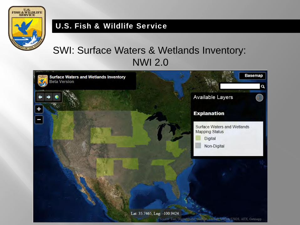
SWI: Surface Waters & Wetlands Inventory: NWI 2.0
• Single composite database of landscape-level NWI wetland and surface water/hydrography data
• Assembled at a State-scale • Seemless data layer, within and across state boundaries • Complete ecological descriptions/Cowardin classification maintained • Constructed for geospatial analysis/modeling • Traceable water flow paths
U.S. Fish & Wildlife Service
SWI: Surface Waters & Wetlands Inventory: NWI 2.0

U.S. Fish & Wildlife Service
SWI: Surface Waters & Wetlands Inventory: NWI 2.0

U.S. Fish & Wildlife Service
SWI: Surface Waters & Wetlands Inventory: NWI 2.0

U.S. Fish & Wildlife Service
Addition of “Riparian” Data
The term “riparian” may be viewed from different perspectives, and has many definitions. In1997, the western Regions of the Service developed a classification system to identify riparian areas that fell outside of the Cowardin et al. (1979) system. Since that time, “A System for Mapping Riparian Areas in the Western United States” (USFWS 2009) has also been adopted by the Service and is a national standard for riparian mapping, monitoring and data reporting as determined by the Federal Geographic Data Committee. The definition is indicated below: Riparian areas are plant communities contiguous to and affected by surface and subsurface hydrologic features of perennial or intermittent lotic and lentic water bodies (rivers, streams, lakes, or drainage ways). Riparian areas have one or both of the following characteristics:1)distinctly different vegetative species than adjacent areas, and 2) species similar to adjacent areas but exhibiting more vigorous or robust growth forms. Riparian areas are usually transitional between wetland and upland.

U.S. Fish & Wildlife Service
Applicability of “Riparian” Data
Riparian areas are plant communities contiguous to and affected by surface and subsurface hydrologic features of perennial or intermittent lotic and lentic water bodies (rivers, streams, lakes, or drainage ways). Riparian areas are usually transitional between wetland and upland.
U.S. Fish & Wildlife Service
Importance of Riparian Habitats
• Greater than 75 percent of terrestrial wildlife species in the Great Basin region of eastern Oregon, as well as in southeastern Wyoming, are dependent on riparian habitats.
• In Arizona and New Mexico, 80 percent of all vertebrates use riparian areas for at least half their life cycles; more than half of these are totally dependent on riparian areas.
• 60 - 75 percent of Arizona's resident wildlife species depend on riparian areas to sustain their populations, yet these areas occupy less than 0.5 percent of the state's land area.
• Aquatic and fish productivity are directly related to a properly functioning and healthy riparian habitat (Washington Dept. Fish and Wildlife 1995).

U.S. Fish & Wildlife Service

U.S. Fish & Wildlife Service
Riparian habitats adjacent to Santa Fe River.

U.S. Fish & Wildlife Service
Forested riparian areas associated with, but not flooded by drainage.

U.S. Fish & Wildlife Service
More Information National Wetlands Inventory Website:
http://www.fws.gov/wetlands
Facebook: https://www.facebook.com/USFWSWetlands
Contact
Jim Dick, Regional Wetlands Coordinator USFWS, Southwest Region, Albuquerque, NM
505-248-6660 [email protected]