Embed Size (px)
Citation preview

Lake Umbagog National Wildlife RefugeDraft Comprehensive Conservation Plan and Environmental Impact Statement
Summary
June 2007
U.S. Fish & Wildlife Service
The U.S. Fish and Wildlife Service is the principal Federal agency responsible for conserving, protecting, and enhancing fish, wildlife, plants, and their habitats for the continuing benefit of the American people. The Service manages the 95-million acre National Wildlife Refuge System comprised of more than 545 national wildlife refuges and thousands of waterfowl production areas. It also operates 65 national fish hatcheries and 78 ecological services field stations. The agency enforces Federal wildlife laws, manages migratory bird populations, restores nationally significant fisheries, conserves and restores wildlife habitat such as wetlands, administers the Endangered Species Act, and helps foreign governments with their conservation efforts. It also oversees the Federal Assistance Program which distributes hundreds of millions of dollars in excise taxes on fishing and hunting equipment to state wildlife agencies.
Comprehensive Conservation Plans provide long term guidance for management decisions and set forth goals, objectives, and strategies needed to accomplish refuge purposes and identify the Service’s best estimate of future needs. These plans detail program planning levels that are sometimes substantially above current budget allocations and, as such, are primarily for Service strategic planning and program prioritization purposes. The plans do not constitute a commitment for staffing increases, operational and maintenance increases, or funding for future land acquisition.
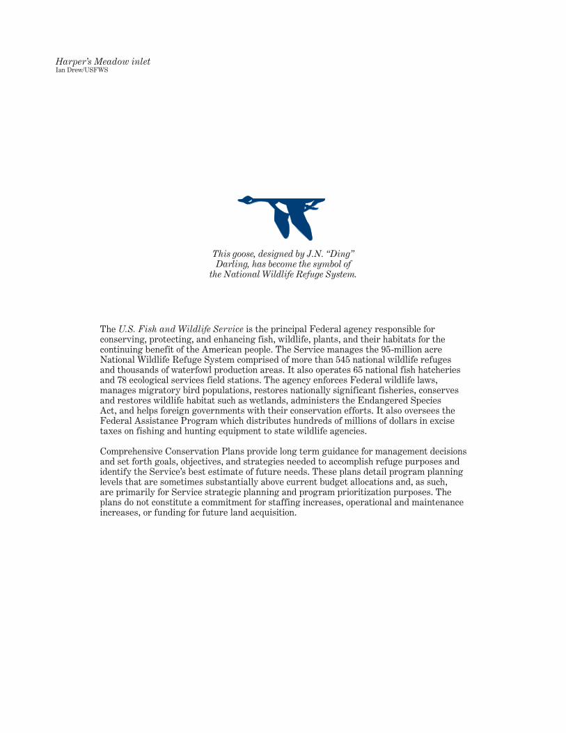
This goose, designed by J.N. “Ding” Darling, has become the symbol of
the National Wildlife Refuge System.
Harper’s Meadow inletIan Drew/USFWS
Summary i
Abstract
Lake Umbagog National Wildlife RefugeDraft Comprehensive Conservation Plan and Environmental Impact Statement
Abstract Administrative
U.S. Department of the Interior, Fish and Wildlife Service
Marvin Moriarty, Regional Director, Region 5
Nancy McGarigal, Planning Team LeaderU.S. Fish and Wildlife Service, Region 5300 Westgate Center DriveHadley, MA 01035(413) 253–8562; [email protected]
The “Draft Comprehensive Conservation Plan and Environmental Impact Statement for the Lake Umbagog National Wildlife Refuge” fully compares three management alternatives. Its 14 appendixes provide additional information supporting our analysis.
This “no action” alternative, required by regulations under the National Environmental Policy Act of 1969, would simply extend the way we now manage the refuge over the next 15 years. It also provides a baseline for comparing the two “action” alternatives. We would continue to protect the refuge from external threats, monitor its key resources, and conduct baseline inventories to improve our knowledge of its ecosystem. We would continue our public use programs for wildlife observation, hunting and fishing, allow snowmobiling and camping at their present capacities in designated areas, and offer limited environmental education and interpretation. We would continue to acquire from willing sellers 6,392 acres within the approved refuge boundary, adding to its current 20,513 acres.
We recommend this alternative for approval. Its highest priority is to protect the biological integrity, diversity, and environmental health of Umbagog Lake and its associated rivers and tributaries. Its second priority is to conserve the upland mixed forest and associated species. Management will focus on enhancing habitats for selected refuge focal species: species of regional conservation concern whose habitat needs generally represent the needs of many other federal trust resources. Alternative B would also improve the quality of our wildlife-dependent recreation programs, and strengthen our partnerships with state and local entities offering similar programs in the area. Another partnership would focus on developing a Land Management Research Demonstration (LMRD) program for applying the best available science in management decisions that affect wildlife resources in the Northern Forest. This alternative includes expanding the refuge as part of a network of conservation lands by acquiring 49,718 acres from willing sellers: 65 percent in fee simple and 35 percent in easements. Those habitats are important for conserving refuge focal species and other federal trust resources. Alternative B also proposes a new refuge headquarters and visitor contact facility. Refuge staffing and budgets would increase commensurately.
This alternative focuses not so much on benefiting selected species, but rather, on passively or actively manipulating vegetation to create or hasten the development of natural communities, landscape patterns and processes. Similar to alternative B, it improves wildlife-dependent recreation, strengthens our partnerships, develops the LMRD program, and adds a new headquarters and visitor contact facility. It expands the refuge by 76,304 acres, which we will purchase in fee simple from willing sellers. Our target is to create contiguous blocks of hydrologically connected conservation habitat greater than 25,000 acres: the size we estimate as the minimum necessary to facilitate the natural progression of ecological processes in the Northern Forest conservation network.
Type of action:Type of action:
Lead agency:Lead agency:
Responsible official:Responsible official:
For further information:For further information:
Alternative A.—Current Management:Alternative A.—Current Management:
Alternative B.—Focal Species Habitat Management (Service-preferred):
Alternative B.—Focal Species Habitat Management (Service-preferred):
Alternative C.—Natural Landscape Composition, Patterns, and Processes Management:
Alternative C.—Natural Landscape Composition, Patterns, and Processes Management:
Table of ContentsIntroduction . . . . . . . . . . . . . . . . . . . . . . . . . . . . . . . . . . . . . . . . . . . . . Sum-1Proposed Action . . . . . . . . . . . . . . . . . . . . . . . . . . . . . . . . . . . . . . . . . . Sum-1Purpose and Need for Action . . . . . . . . . . . . . . . . . . . . . . . . . . . . . . . . . . Sum-1Brief History and Purposes for Establishing the Refuge . . . . . . . . . . . . . . . . . . Sum-2Refuge Setting and its Resources . . . . . . . . . . . . . . . . . . . . . . . . . . . . . . . Sum-2Refuge Complex Vision and Goals . . . . . . . . . . . . . . . . . . . . . . . . . . . . . . . Sum-6Alternatives Considered, Including the Service-Preferred Alternative. . . . . . . . . Sum-7Actions Common to All of the Alternatives . . . . . . . . . . . . . . . . . . . . . . . . . . Sum-8Actions Common to Alternatives B and C Only . . . . . . . . . . . . . . . . . . . . . . Sum-10Alternative A – Current Management . . . . . . . . . . . . . . . . . . . . . . . . . . . . Sum-11Alternative B – Preferred Alternative: Management for Particular
Habitats and Focal Species. . . . . . . . . . . . . . . . . . . . . . . . . . . . . . . . . Sum-14Alternative C – Management to Create Natural Landscape Composition,
Patterns, and Processes . . . . . . . . . . . . . . . . . . . . . . . . . . . . . . . . . . Sum-19Summary Comparison of Management Actions by Alternative . . . . . . . . . . . . Sum-24Environmental Consequences. . . . . . . . . . . . . . . . . . . . . . . . . . . . . . . . . Sum-31
Table of Contents
Table of Contents iii
List of MapsMap 1 Refuge Setting and its Resources . . . . . . . . . . . . . . . . . . . . . . Sum-3Map 2 Refuge Setting and its Resources . . . . . . . . . . . . . . . . . . . . . . Sum-4Map 3 Refuge Setting and its Resources . . . . . . . . . . . . . . . . . . . . . . Sum-5Map 4 Actions Common to All of the Alternatives . . . . . . . . . . . . . . . . . Sum-9Map 5 Alternative A – Current Management . . . . . . . . . . . . . . . . . . . Sum-12Map 6 Alternative A – Current Management . . . . . . . . . . . . . . . . . . . Sum-13Map 7 Alternative B – Preferred Alternative: Management for Particular Habitats
and Focal Species . . . . . . . . . . . . . . . . . . . . . . . . . . . . . . . Sum-15Map 8 Alternative B – Preferred Alternative: Management for Particular Habitats
and Focal Species . . . . . . . . . . . . . . . . . . . . . . . . . . . . . . . Sum-16Map 9 Alternative B – Preferred Alternative: Management for Particular Habitats
and Focal Species . . . . . . . . . . . . . . . . . . . . . . . . . . . . . . . Sum-18Map 10 Alternative C – Management to Create Natural Landscape Composition,
Patterns, and Processes . . . . . . . . . . . . . . . . . . . . . . . . . . . Sum-21Map 11 Alternative C – Management to Create Natural Landscape Composition,
Patterns, and Processes . . . . . . . . . . . . . . . . . . . . . . . . . . . Sum-22Map 12 Alternative C – Management to Create Natural Landscape Composition,
Patterns, and Processes . . . . . . . . . . . . . . . . . . . . . . . . . . . Sum-23
List of TablesTable 1 Summary comparison of management actions by alternative
and their relationship to goals and significant issues . . . . . . . . Sum-24
Summary Sum-1
As part of its congressional mandate, the U.S. Fish and Wildlife Service conserves habitat and protects fish, wildlife and plants on the more than 545 refuges in the National Wildlife Refuge System (Refuge System), in cooperation with the American public, States, and our other partners in conservation. On the public lands in that System, “Wildlife Comes First.”
The Lake Umbagog National Wildlife Refuge comprises 20,513 acres in Coos County, New Hampshire, and Oxford County, Maine. It protects the wetlands, habitats and species noted for their importance in the Upper Androscoggin River watershed.
We prepared the draft Comprehensive Conservation Plan and Environmental Impact Statement (draft CCP/EIS) to describe three alternatives for managing the refuge for the next 15 years. Each alternative proposes varying strategies to achieve important objectives in managing habitat, species, and public use. Two alternatives also propose to expand the boundary of the refuge by a number of acres determined in part by the environmental impacts of implementing those strategies and achieving those objectives. This document summarizes that draft CCP/EIS.
We propose to implement a CCP for the refuge that best achieves its vision and goals, best addresses its significant management issues, best conforms to its conservation mandates, best applies sound science in managing fish and wildlife, and best contributes to the mission of the System.
We examined a wide range of alternatives for managing the refuge. From among them, we fully developed three. We then selected as our preferred alternative the one that, in our professional judgment, would best accomplish all of the actions above.
Alternative B.—Focal Species Habitat Management: This Service-preferred alternative manages refuge habitats for selected focal species, improves existing opportunities for compatible, wildlife-dependent recreation, and proposes a refuge expansion of 49,718 acres acquired from willing sellers as part of a regional conservation lands network.
Our purpose in developing a CCP by fully involving others is crucial for our future success. It allows interested individuals, organizations, and elected officials to engage in resolving management issues and public concerns. The CCP explains the reasons for our management actions, and clearly links them to desired future conditions for refuge habitat, wildlife, visitor services, staffing, and facilities. It ensures that our refuge management conforms to the mandates of the System, and that wildlife-dependent recreational uses are compatible with the purposes for which the refuge was established. Finally, it provides long-term direction and continuity in developing refuge program priorities and annual budgets.
Our need to develop a CCP for the refuge is manifold. The National Wildlife Refuge System Improvement Act of 1997 requires us to write CCPs for all national wildlife refuges by 2012 to help fulfill the mission of the Refuge System. This refuge lacks a master plan to accomplish the actions above; yet, the economy and land ownership patterns in local communities have changed; pressures for public access have continued to grow; and new ecosystem and species conservation plans bearing directly on refuge management have developed. In response, we need to evaluate locations for a proposed new refuge headquarters and visitor contact facility. We have developed strong partnerships vital for our continued success, and we must convey to them our vision for the refuge. Finally, we need a CCP to guide us in future land conservation designed to sustain federal trust species and wetlands in the Northern Forest. Refuge lands are
IntroductionIntroduction
Proposed ActionProposed Action
Purpose and Need for ActionPurpose and Need for Action
Proposed Action
Summary
part of a much larger land conservation partnership network. Map 1 depicts the refuge in relationship to other conserved land in the Upper Androscoggin River Watershed.
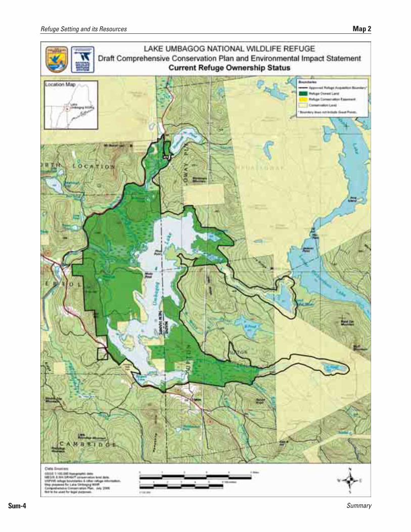
Congress authorized the establishment of the refuge in 1992 for the purposes of conserving the unique diversity of wetlands habitats and associated wildlife and protecting water quality in the area. The current, approved acquisition boundary for the refuge encompasses 26,905 acres. The Service has acquired 20,513 acres, leaving 6,392 acres still to be acquired as funding and landowner interest permit. The refuge has acquired most of its land in the last 5 years. Map 2 depicts the current refuge boundary.
The refuge was established for the following purposes, under the following authorities:
“the conservation of the wetlands of the Nation in order to maintain the public benefits they provide and to help fulfill international obligations contained in various migratory bird treaties and conventions….” [Emergency Wetlands Resources Act of 1986; 16 U.S.C. 3901(b)];
“for use as an inviolate sanctuary, or for any other management purpose, for migratory birds.” [Migratory Bird Conservation Act; 16 U.S.C. 715d];
“for the development, advancement, management, conservation, and protection of fish and wildlife resources….” [Fish and Wildlife Act of 1956; 16 U.S.C. 742f(a)(4)]; and
“for the benefit of the United States Fish and Wildlife Service, in performing its activities and services. Such acceptance may be subject to the terms of any restrictive or affirmative covenant, or condition of servitude….” [16 U.S.C. 742f(b)(1)]
In the draft CCP/EIS, appendix A, “Land Protection Plan,” describes the lands we have acquired, and the lands we propose to acquire in expanding the refuge under the Service-preferred alternative.
The towns of Errol, New Hampshire (pop. 298) and Upton, Maine (pop. 62) are the communities closest to the refuge. Historically they have had strong ties to forest-dependent industries: namely, lumber and paper. The recreation industry, based on activities such as snowmobiling and motor boating, is becoming increasingly important economically. The current refuge staff of five is headquartered in Errol. One of the refuge manager’s priorities has been to develop a positive relationship with these and other towns in the two-county area.
Geographically, the refuge lies in the Upper Androscoggin River watershed, a broad valley nearly surrounded by mountains above 3,000 feet. Refuge habitats are very diverse: approximately 50 percent of its 20,513 acres consists of wetlands, open water or floodplain; 50 percent is upland forest. They include several rare, unique wetland plant communities: namely, bog and peat lands, including the 850-acre Floating Island National Natural Landmark. The upland forest primarily consists of a mix of three habitat types: spruce-fir, mixed woods, and northern hardwoods. That diverse habitat supports a wide assemblage of wildlife native to the Northern Forest ecosystem. Federal-listed bald eagles nest on the refuge, as do 11 state-listed birds, including the highly visible osprey, common loon, and several species of waterfowl. Three state-listed mammals also live on the refuge. Map 3 depicts current habitats and their distribution on the refuge.
Brief History and Purposes for Establishing the Refuge
Brief History and Purposes for Establishing the Refuge
Refuge Setting and its Resources Refuge Setting and its Resources
Brief History and Purposes for Establishing the Refuge
Sum-2

Summary Sum-3
Map 1 Refuge Setting and its Resources
SummarySum-4
Refuge Setting and its Resources Map 2

Summary Sum-5
Map 3 Refuge Setting and its Resources

Summary
The refuge is a very popular destination, especially for water recreation. It is now open for hunting, wildlife observation and photography, and environmental education and interpretation. We also allow snowmobiling and camping in designated locations. Chapter 3 of the draft CCP/EIS presents detailed descriptions of the refuge setting and its natural and cultural resources.
“We envision Umbagog National Wildlife Refuge as an essential link in the network of conservation lands in the Northern Forests. We will showcase science-based, adaptive management in a working forest landscape and provide an outstanding center for research. We will achieve this through strong partnerships with State agencies, conservation organizations, land managers, and neighboring communities.
“Our management will perpetuate the diversity and integrity of upland spruce-fir and northern hardwood forests, boreal and riverine wetlands, and lake habitats for the continued health of native fish and wildlife populations. These habitats will provide an important regional breeding area for migratory land birds, waterfowl, and other species of regional significance, such as the common loon and bald eagle.
“Visitors of all ages will feel welcome to enjoy the full complement of priority wildlife-dependent public uses. We will foster their knowledge of and support for conserving northern forest habitats through exceptional outreach and visitor programs. We want all our visitors to return home filled with enthusiasm for promoting and practicing resource stewardship in their own communities.
“We hope residents of neighboring communities in Maine and New Hampshire will value the refuge for enhancing their quality of life. Within the National Wildlife Refuge System, the refuge will be treasured for conserving Federal trust resources and providing inspirational outdoor experiences for present and future generations of Americans.”
These are intentionally broad statements of our purposes and the focus of our management actions. We have not ranked them in any sequence; however, the biological goals will take precedence in decisions about refuge management.
Goal 1: Manage open water and wetland habitats to benefit Federal trust species and other species of conservation concern.
Goal 2: Manage floodplain and lakeshore forests to benefit Federal trust species and other species of conservation concern.
Goal 3: Manage upland forest habitats, consistent with site capabilities, to benefit Federal trust species and other species of conservation concern.
Goal 4: Provide high quality wildlife-dependent activities such as hunting, fishing, wildlife observation and photography.
Goal 5: Develop high-quality interpretative opportunities, and facilitate environmental education, to promote an understanding and appreciation for the conservation of fish and wildlife and their habitats, as well as the role of the refuge in the Northern Forest.
Refuge Complex Vision and GoalsRefuge Complex Vision and Goals
VisionVision
GoalsGoals
Sum-6
Refuge Complex Vision and Goals
Summary
Goal 6: Enhance the conservation and management of wildlife resources in the Northern Forest Region through partnerships with public and private conservation groups, private landowners, State and local entities.
Goal 7: Develop the refuge as an outstanding center for research and development of applied management practices to sustain and enhance the natural resources in the Northern Forest in concern with the Land Management and Research Demonstration Area program.
Relating Goals, Objectives, and StrategiesRefuge goals and objectives define each of the management alternatives identified below. Developing refuge goals was one of the first steps in our planning process. By design, they are less quantitative, and more prescriptive, in defining the targets of our management. All of the goals appear in each of the alternatives.
Objectives are essentially incremental steps toward achieving a goal; they also further define the management targets in measurable terms. They typically vary among the alternatives and provide the basis for determining more detailed strategies, monitoring refuge accomplishments, and evaluating our success.
Strategies are specific actions, tools, techniques, or a combination of those that we may use to achieve the objective. We will evaluate most of the strategies further as to how, when, and where refuge step-down plans should implement them.
Developing Alternatives, including the “No Action” AlternativeSimply put, alternatives are packages of complementary objectives and strategies designed to meet refuge purposes and goals, the Refuge System mission, while responding to the issues and opportunities identified during the planning process. We fully analyze in this draft CCP/EIS three alternatives which characterize different ways of managing the refuge over the next 15 years. We believe they represent a reasonable range of alternative proposals for managing the refuge.
Alternative A satisfies the National Environmental Policy Act (NEPA) requirement of a “no action” alternative, which we define as “continuing current management.” It describes our existing management priorities and activities, and serves as a baseline for comparing and contrasting alternatives B and C.
Alternative B, the Service-preferred alternative, combines the actions we believe would most efficiently and effectively achieve refuge purposes, vision and goals, and respond to public issues. It emphasizes management of specific refuge habitats to support focal species whose habitat needs benefit other species of conservation concern in the Northern Forest. In particular, we emphasize habitat for priority bird species of conservation concern identified for the Northern Forest Ecosystem Bird Conservation Region (BCR 14).
Alternative C emphasizes management to restore, where practicable, the distribution of natural communities in the Upper Androscoggin River watershed that would have resulted from natural processes without the influence or intervention of human settlement and management. While this alternative does not propose breaching the Errol Dam that expanded Umbagog Lake, it proposes actions to modify the flow and timing of water to mimic the annual natural historic high and low water events, within the requirement of the existing Federal Energy Regulatory Commission (FERC) license. In the uplands, it proposes actions to restore the structure and function of native vegetation that resulted from natural historic ice and windstorms.
Alternatives Considered, Including the Service-Preferred Alternative
Alternatives Considered, Including the Service-Preferred Alternative
Sum-7
Alternatives Considered, Including the Service-Preferred Alternative
Summary
Although the alternatives differ in many ways, they also share some similarities. These are highlights of some of the actions common to all alternatives.
All alternatives include the same schedule for completing 11 refuge step-down plans. We will assign first priority to the Habitat Management Plan (HMP), which we will complete within 1 year of CCP approval.
Continue to work cooperatively with the licensee of the Errol Project (currently Florida Power & Light Energy Hydro Maine, LLC (FPLE)). Specifically under Article 27 of the current license, we will continue to develop a yearly water level management plan with the licensee and other regulatory agencies “to benefit nesting wildlife”; pursue a Memorandum of Understanding (MOU) with the current licensee to formalize coordination within the current FERC boundary.
Develop a list of invasive species of greatest concern on the refuge, identify priority areas with which to be vigilant, and establish monitoring and treatment strategies.
Continue to work with state agencies to prevent introduction of invasive species to all water bodies on the refuge; increase enforcement to check boats and equipment to protect against invasive plant transport
Initiate several priority studies during 2006–2007, including visitor use and impact; wildlife disturbance; ecological systems analysis to identify the ecological processes that historically and currently influence the lake; and, a baseline contaminants assessment.
Continue to coordinate with state agencies in the monitoring of bald eagle, osprey, and loon nests, and to evaluate the effectiveness of our protection measures
Work with the Lynx Recovery Team to determine whether a monitoring or inventory program on the refuge is warranted.
Develop a priority list of monitoring and inventory needs for the 15-year planning cycle.
Conserve and maintain all natural vernal pools, including those pools embedded in wetland or riparian habitats, on existing refuge lands and within the respective refuge expansion areas.
Conserve and protect cliffs, talus slopes, and other unique, significant, or rare upland habitat types identified on these same lands.
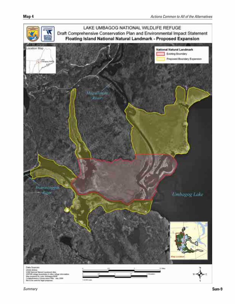
In cooperation with the National Park Service (NPS), expand the boundary of the FINNL to one that is more ecologically based using the 2002-2003 vegetation survey results (see map 4).
Convene a workshop with wetlands ecologists to determine what information should be collected and what monitoring should occur to document any potential loss or degradation.
Create an Umbagog Lake Working Group, whose mission would be to voluntarily coordinate, facilitate, or streamline management affecting the lake as a partnership to reduce resource threats and resolve user conflicts on the lake and associated rivers.
■
■
■
■
■
■
■
■
■
■
■
■
■
Actions Common to All of the AlternativesActions Common to All of the AlternativesDeveloping Refuge Step-down PlansDeveloping Refuge Step-down Plans
Coordinating Umbagog Lake Water Level Management
Coordinating Umbagog Lake Water Level Management
Controlling Invasive Plant SpeciesControlling Invasive Plant Species
Implementing and Prioritizing a Biological Monitoring and Inventory Program
Implementing and Prioritizing a Biological Monitoring and Inventory Program
Protecting Vernal Pools and other Unique or Rare Communities
Protecting Vernal Pools and other Unique or Rare Communities
Expanding and Protecting the Floating Island National Natural Landmark (FINNL)
Expanding and Protecting the Floating Island National Natural Landmark (FINNL)
Creating an Umbagog Lake “Working Group” Creating an Umbagog Lake “Working Group”
Sum-8
Actions Common to All of the Alternatives
Summary Sum-9
Map 4 Actions Common to All of the Alternatives

Summary
Ensure compliance with section 106 of the National Historic Preservation Act. Evaluate the potential for refuge projects to impact archeological and historical resources, and consult with respective State Historic Preservation Offices (SHPOs). Compliance may require any or all of the following: a State Historic Preservation Records survey, literature survey, or field survey.
Fill our currently approved but vacant positions we believe necessary to accomplish our highest priority projects. Alternatives B and C also propose additional staff to provide depth in our biological and visitor services programs.
Establish a new headquarters and visitor contact facility at the Potter Farm site. Alternatives A and B propose a small office facility, defined by the new Service facility standards, while alternative C proposes a medium office facility.
Maintain the present headquarters building as a research or auxiliary field office.
Change the name of the refuge to “Umbagog National Wildlife Refuge,” to better represent the broader geographic context and management emphasis we would pursue under all alternatives.
Continue to allow priority public uses such as hunting, wildlife observation and photography, and environmental education and interpretation, and officially open the refuge to fishing.
Continue to allow camping and snowmobiling in designated areas.
Continue to conduct outreach and enforce against activities not allowed on the refuge including: sled dog mushing, mountain biking, horseback riding, ATV or ORV or motorbike use, competitions or organized events (e.g. fishing derbies, dog trials, or mountain bike, foot, cross-country ski, or boat races), and geocaching.
Actively manage upland forested habitats, within site compatibility and natural potential, to achieve habitat and wildlife objectives.
All commercial and non-commercial tree cutting would adhere to accepted silvicultural prescriptions, and the best management practices in each respective state at a minimum.
Our management activities in the proposed expansion areas, within the 15 year life of this CCP, would be more pre-commercial operations in nature, such as thinning, habitat restoration (e.g. restoring log landings, slash piles, etc), and/or vegetation manipulations to create openings and enhance woodcock habitat in woodcock focus areas.
Within three years of CCP approval, develop a furbearer management plan. Establish furbearer management units as warranted and identify where habitat management or reintroductions, increases, or reductions of native furbearer species, such as beaver, is desirable.
■
■
■
■
■
■
■
■
■
■
■
■
Protecting Cultural ResourcesProtecting Cultural Resources
Refuge Staffing and Administration Refuge Staffing and Administration
Visitor Services Visitor Services
Actions Common to Alternatives B and C Only
Actions Common to Alternatives B and C Only
Implementing Forest Management to Achieve Habitat Objectives
Implementing Forest Management to Achieve Habitat Objectives
Implementing a Furbearer Management ProgramImplementing a Furbearer Management Program
Sum-10
Actions Common to Alternatives B and C Only
Summary
Construct a series of interpretive trails at the Potter Farm site; at least one would be designed to allow travel by people with disabilities.
Provide additional visitor facilities along major travel routes, including roadside pullouts on Routes 16, and a roadside pullout with overlook platform on Route 26. Each of these sites would have an information kiosk, and provide parking for several vehicles.
Complete a ¼-mile loop extension to the Magalloway River trail accessible to people with disabilities.
Within one year of CCP approval, initiate administrative process to open the refuge to two new seasons: turkey hunting on refuge lands in both states, and a bobcat hunt on refuge lands in Maine. A new Hunt Plan package, including associated NEPA document, Federal Register Notice, and public involvement would be required.
Pursue a refuge expansion, through fee acquisition and/or conservation easements, to support habitat and species goals and objectives; size of expansion varies by alternative.
This alternative portrays current, planned, or approved management activities, and is the baseline for comparing the other two alternatives. Our biological program would continue its present priorities, such as cooperating with partners in the monitoring of loon, bald eagle, and osprey populations on the lake; protecting loon, bald eagle, and osprey active nest sites from human disturbance on refuge lands; and, conducting annual bird and amphibian inventories according to regional protocols. We would continue those projects with the help of volunteers, our conservation partners, and our own staff as funding and staffing allow. We would continue to facilitate biological research studies, if they would benefit the Service and the refuge manager determines them compatible. Map 5 depicts the broad habitat types we predict would result after 100 years of implementing the management objectives in alternative A.
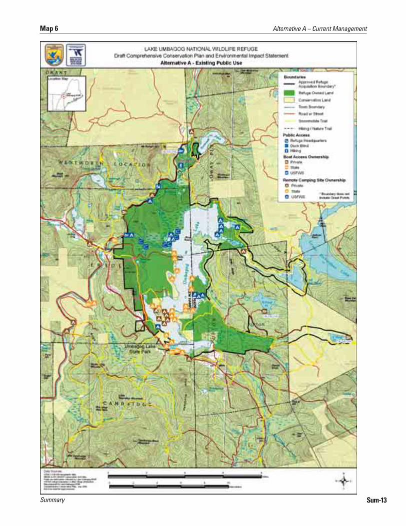
As for visitor services, we would continue to offer hunting and fishing opportunities on refuge lands, and respond to requests for interpretive and school programs. However, we would not to be able to meet most requests because of limited staff and resources. We would also continue to partner with the State of New Hampshire to provide remote camping sites on Umbagog Lake. We would continue to allow snowmobiling confined to the designated trails. The Magalloway River Trail would continue to be the only walking trail maintained on the refuge. We would continue to coordinate two annual community events: the “Umbagog Wildlife Festival” and “Take Me Fishing.” Map 6 depicts the public use facilities under current management.
We would continue to seek acquisition from willing sellers of the 6,392 acres that remain in private ownership within our currently approved acquisition boundary.
■
■
■
■
■
Enhancing Visitor ProgramsEnhancing Visitor Programs
Expanding the Refuge BoundaryExpanding the Refuge Boundary
Alternative A – Current ManagementAlternative A – Current Management
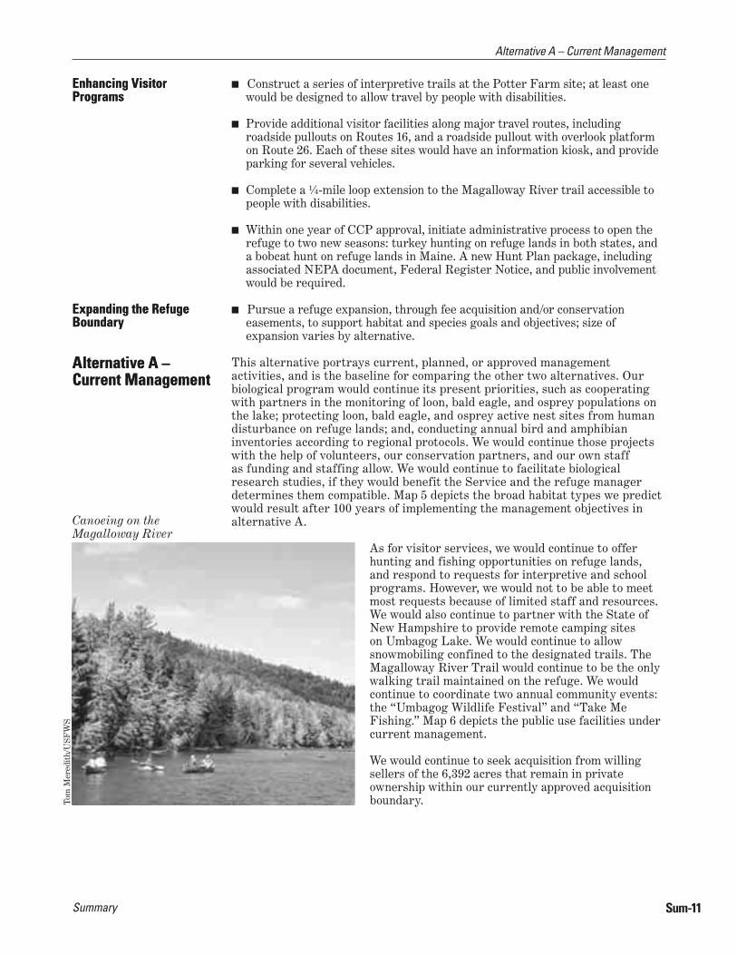
Canoeing on the Magalloway River
Tom
Mer
edit
h/U
SFW
S
Alternative A – Current Management
Sum-11

SummarySum-12
Alternative A – Current Management Map 5
Summary Sum-13
Map 6 Alternative A – Current Management

Summary
Alternative B is the alternative our planning team favors for implementation. It includes an array of management actions that, in our professional judgment, work best toward achieving the refuge purposes, its vision and goals, and contribute to conserving federal trust resources of concern in the Northern Forest. This alternative would most effectively address the significant issues identified in chapter 1 of the draft CCP/EIS. We believe it is reasonable, feasible, and practicable within the 15-year period of the CCP.
We designed this alternative to emphasize the conservation of a mixed forest matrix landscape and its component habitat types: spruce-fir, mixed woods, and northern hardwoods. Our analysis of site capability and natural potential indicates that the refuge is in a unique position to make an important contribution to the mixed forest matrix in the watershed, as well as in the larger Northern Forest landscape, and within the Refuge System. The three habitat types we describe support a wide variety of federal trust resources: in particular, birds of conservation concern identified in the BCR 14 region and those that depend on wetlands. We identify focal species for each habitat type objective whose life requirements would guide management activities in that habitat type. We selected those focal species because, in our opinion, they are federal trust resources whose habitat needs broadly represent the habitat requirements for most of the other federal trust species and native wildlife dependent on that habitat type.
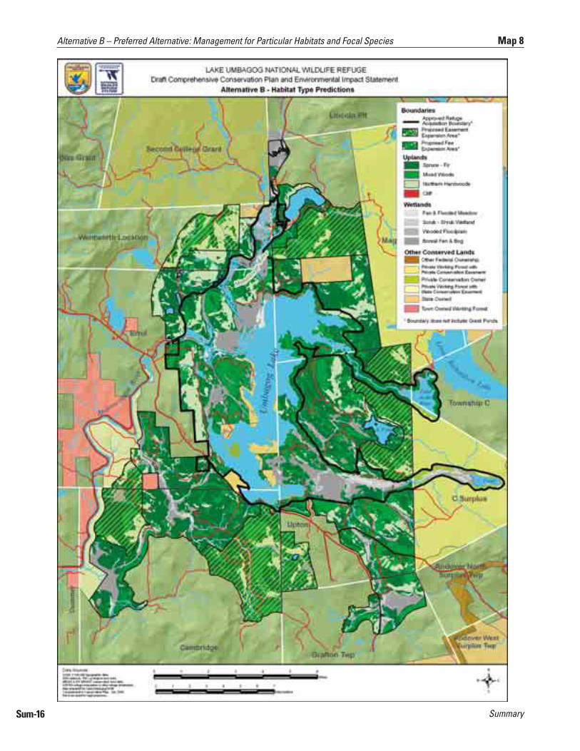
Appendix N in the draft CCP/EIS describes in detail our process for selecting focal species by habitat type. Our actions in alternative B for Goals 1–3 below identify the habitat type, acres conserved, and the focal species that would be a target of our management. The presentation in the draft CCP/EIS includes a rationale that identifies each focal species’ particular habitat needs. We identify strategies as potential management actions for accomplishing the objectives and meeting those habitat needs. Map 8 depicts the broad habitat types we predict would result after approximately 100 years of implementing the management objectives in alternative B for upland habitats.
Similar to alternative A, and in keeping with the original purposes for which we established the refuge, the wetlands actions under goal 1 are our highest priority for implementation in the biological program. Protecting the biological integrity, diversity, and environmental health of Umbagog Lake and its associated rivers is paramount. As our second habitat management priority under alternative B, we propose implementing the actions under goal 3, which would promote and sustain a mixed forest matrix: that is, a mosaic of spruce-fir, mixed woods, and northern hardwood habitat types, with emphasis on promoting the conifer component. As our third habitat management priority, we propose to implement those actions that would improve American woodcock habitat.
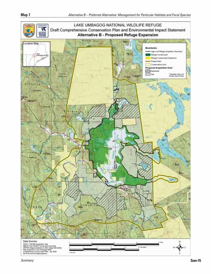
In support of those priorities and our other habitat goals and objectives, alternative B proposes to expand the existing, approved refuge boundary by 49,718 acres, through a combination of Service acquisition in fee-simple (65 percent) and conservation easement (35 percent) (map 7). All of the lands we propose to acquire are undeveloped. They either are or have the potential to be high quality wildlife habitat. Their amount and distribution provides us management flexibility in achieving our habitat goals and objectives. Collectively, they would form a land base that affords vital links to other conserved lands in the Upper Androscoggin watershed and Northern Forest region. As we acquire lands in fee, we would manage them by the goals, objectives, and strategies under this alternative.
Alternative B – Preferred Alternative: Management for Particular Habitats and Focal Species
Alternative B – Preferred Alternative: Management for Particular Habitats and Focal Species
©R
ober
t Q
uinn
Harper’s Meadow
Alternative B – Preferred Alternative: Management for Particular Habitats and Focal Species
Sum-14
Summary Sum-15
Map 7 Alternative B – Preferred Alternative: Management for Particular Habitats and Focal Species
SummarySum-16
Alternative B – Preferred Alternative: Management for Particular Habitats and Focal Species Map 8

Summary
Our land conservation objectives result from a very active regional partnership, and fully complement the management on both public and private adjacent conserved lands. Our proposal also complements the original purpose and intent for which the refuge was established. It identifies the significance of the refuge expansion in contributing to the current and planned network of conservation lands and wildlife resources in the regional landscape. Working in partnership with these surrounding landowners is crucial for its successful implementation. We developed its strategies cooperatively with our state fish and wildlife agency partners and other land conservation partners working in the Northern Forest region who support it.
Regarding our visitor services programs, alternative B would enhance existing, priority, public use opportunities for hunting and fishing by providing better outreach and information materials and improving access and parking (map 9). We propose to open the refuge to two new hunts as we previously described. Implementation of these hunts would require a separate environmental analysis, including public involvement opportunities. Opportunities for viewing and photographing wildlife and interpretation would expand, primarily providing new infrastructure such as trails and viewing areas. In addition, we propose new roadside pullouts, informational kiosks, and viewing platforms along the major travel corridors. Further, we would develop new visitor infrastructure, including a series of interpretive trails, in conjunction with the proposed new location for a refuge administrative headquarters and visitor contact facility at the former Potter Farm site. We would also pursue a partner-managed regional visitor contact facility in the Town of Errol.
As for other uses of the refuge, we would continue to allow snowmobiling on the trails now designated. In cooperation with the Department of Resources and Economic Development (NH DRED) we would also continue to allow and manage remote camping on the 12 lake sites so designated; although we would increase their monitoring, and rehabilitate or relocate those in need of restoration. We would eliminate the two river sites; we would not replace them. We do not plan to increase opportunities for either snowmobiling or camping. We also plan to open the refuge to furbearer management under permit, in conformance with a Furbearer Management Plan.
Under alternative B, the lands we acquire in the proposed expansion area would be open to long-term public access for compatible, priority public uses such as hunting, fishing, wildlife observation and photography and environmental education and interpretation. We would keep open the major road corridors in the expansion lands to facilitate access to those activities.
We would also enhance local community outreach and partnerships, continue to support a Friends Group, and provide valuable volunteer experiences as we implement alternative B. As described under goal 7, we would pursue the establishment of a Land Management and Research Demonstration (LMRD) site on the refuge to promote research and the development of applied management practices to benefit the species and habitats identified in this alternative.
Ian
Dre
w/U
SFW
S
Fishing on Leonard Pond
Alternative B – Preferred Alternative: Management for Particular Habitats and Focal Species
Sum-17

SummarySum-18
Alternative B – Preferred Alternative: Management for Particular Habitats and Focal Species Map 9
Summary
This alternative strives to establish and maintain the ecological integrity of natural communities on the refuge and surrounding landscape in the Upper Androscoggin River watershed. Ecological integrity is defined by having all native species present, and allowing ecological processes and natural disturbance events to occur within their respective distribution, abundance or frequency, and natural range of variability characteristic of that community type under natural conditions. A natural community with high integrity is also defined as being resilient and able to recover from severe disturbance events. Management under alternative C would range from passive, or “letting nature take its course,” to actively manipulating vegetation to create, or hasten the development of, mature forest structural conditions shaped by natural disturbances. No particular wildlife species are a focus of management.
As a priority, we would implement studies, consult experts, and conduct literature reviews, to further refine our knowledge of disturbance patterns and structural conditions in both wetlands and uplands natural communities. Under alternative C, we would continue to recognize the current FERC license agreement; however, we would also discuss with the licensee opportunities to manage at water levels that mimic a more natural hydrologic flow throughout the year. Our wetland management would also pursue restoration projects where past land uses hinder natural hydrological flow and wetlands development.
In refuge uplands, we would manage to restore the forest communities predicted as the “potential natural vegetation,” using both Kuchler’s delineations of potential types and ecological land units (ELUs), as the basis to determine which types are best -suited and most capable of growing on these sites. Our management would be designed to create similar mature stand structural conditions that would be expected from the natural disturbances that shaped the Northern Forest landscape. Those disturbances include hurricanes, flooding, ice storms, and small blow-downs. We would manage the distribution of forest age-class, species, and diameter, understory development, the amount of dead and dying and cavity trees, large and old trees, coarse woody debris, and canopy closure indicated by historic accounts or as described by experts. Notwithstanding those actions, we would also ensure protection of current or future threatened and endangered species, and control the establishment and spread of any non-native, invasive species. Introduced pests and pathogens, including beech-scale disease, gypsy moth, and hemlock and balsam wooly adelgid, may present management issues in the future that require intervention. Map 11 depicts the broad habitat types we predict would result after approximately 150 years of implementing the management objectives in alternative C.
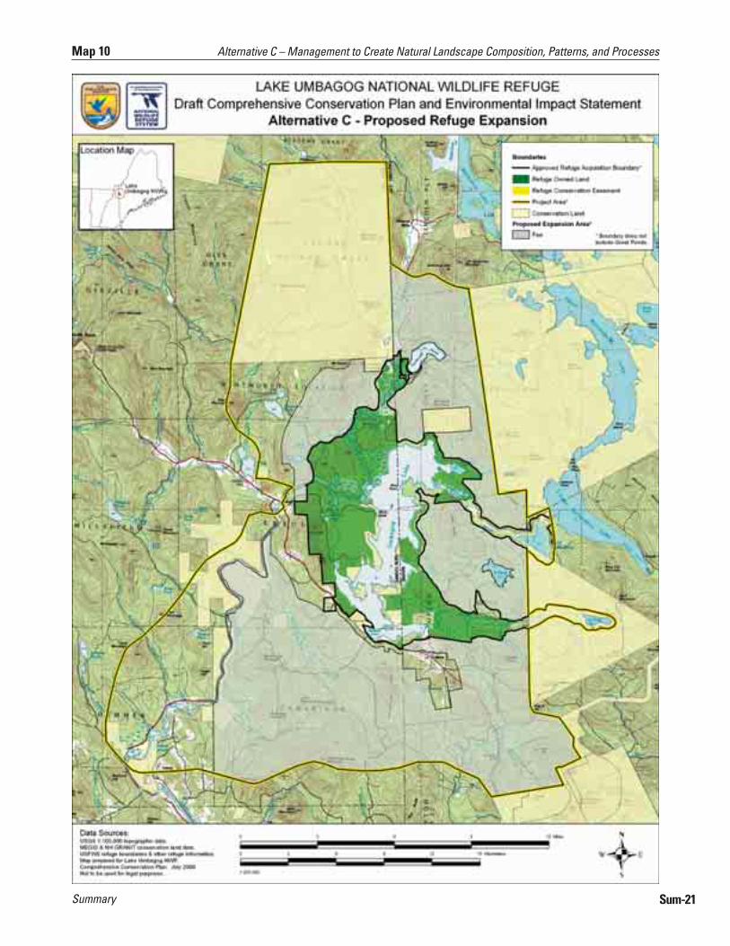
The proposed refuge expansion of 76,304 acres is essential for the success of alternative C (map 10). Experts have suggested that 25,000 contiguous acres, hydrologically connected and in a relatively undisturbed condition, is a reasonable approximation of the minimum size at which ecological processes, structure and function could occur naturally, including the disturbances we identified above. We designed our expansion proposal in alternative C to protect and conserve large, contiguous habitat blocks exceeding 25,000 acres and connect them to other conserved lands. Unlike alternative B, our need for adjacent conservation landowners to work cooperatively and complement our management is less important, because the extent of the lands we propose to acquire would allow
Alternative C – Management to Create Natural Landscape Composition, Patterns, and Processes
Alternative C – Management to Create Natural Landscape Composition, Patterns, and Processes
©R
ober
t Q
uinn
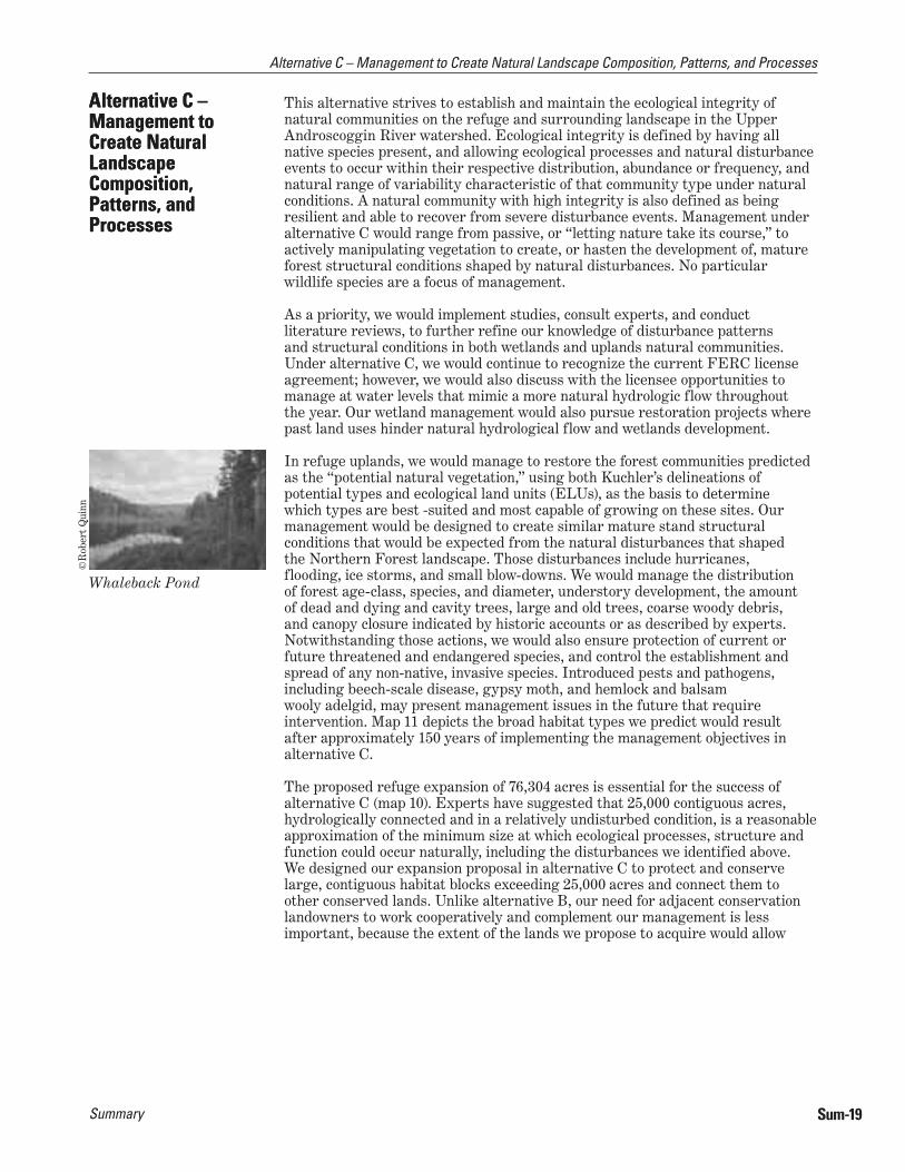
Whaleback Pond
Sum-19
Alternative C – Management to Create Natural Landscape Composition, Patterns, and Processes

Summary
us to meet our objectives independent of adjacent lands. We would acquire all of the 76,304 acres we identified from willing sellers in fee simple. Fee simple acquisition ensures full management control and flexibility. As we acquire those lands, we would manage them by the goals, objectives, and strategies under this alternative.
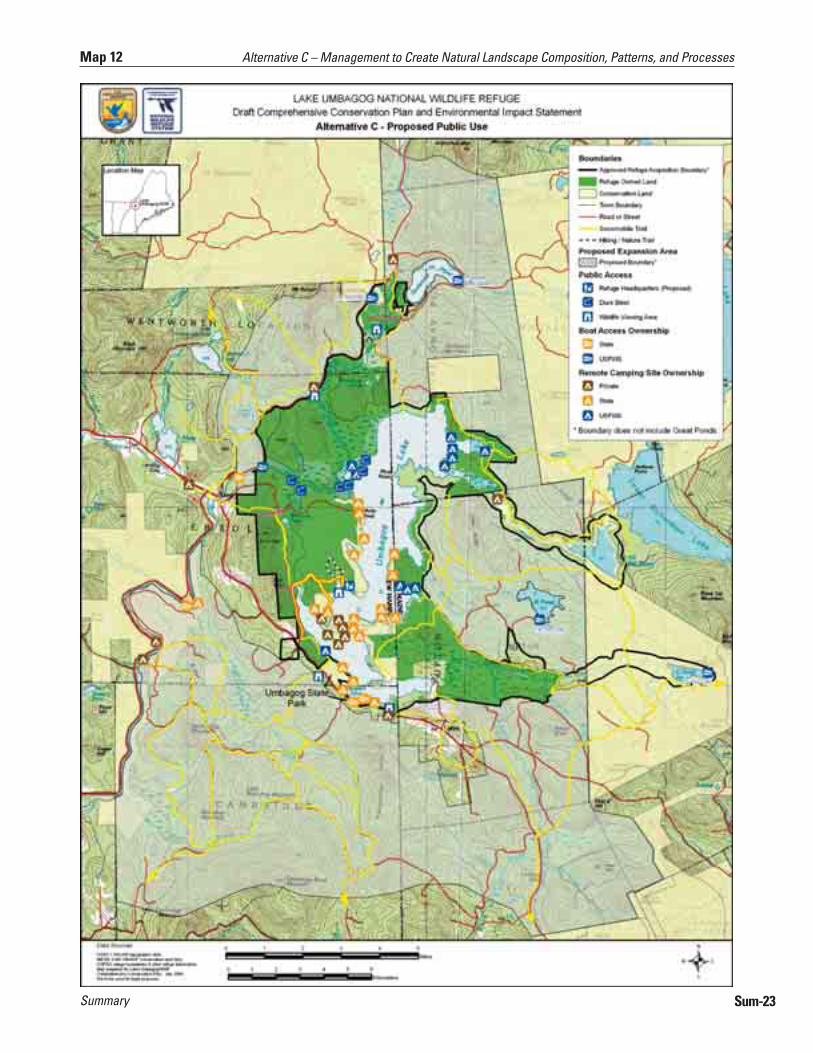
Compared to the proposals in alternative B for visitor services programs and refuge uses, alternative C would limit new infrastructure for wildlife observation, photography, and interpretation to those around the Potter Farm facility and roadside pullouts along Routes 16 and 26; however, it would similarly enhance the existing opportunities for hunting and fishing (map 12). It would also open the refuge for furbearer trapping under permit, although, unlike alternative B, the program would emphasize natural furbearer population dynamics. Like alternative B, remote camping on the existing designated lake sites would continue to be allowed, and we would increase monitoring of individual sites, and rehabilitate, or close permanently or seasonally those in need of restoration.
Also similar to alternative B, under alternative C, we would enhance local community outreach and partnerships, continue to support a Friends Group, and provide valuable volunteer experiences. We would also pursue the establishment of a LMRD site on the refuge to promote research, and the development of applied management practices, to sustain and enhance the natural composition, patterns and processes within their range of natural in the Northern Forest.
Paul
Cas
ey/U
SFW
S
Winter view of the Dead Cambridge
Alternative C – Management to Create Natural Landscape Composition, Patterns, and Processes
Sum-20
Summary Sum-21
Map 10 Alternative C – Management to Create Natural Landscape Composition, Patterns, and Processes

SummarySum-22
Alternative C – Management to Create Natural Landscape Composition, Patterns, and Processes Map 11
Summary Sum-23
Map 12 Alternative C – Management to Create Natural Landscape Composition, Patterns, and Processes
SummarySum-24
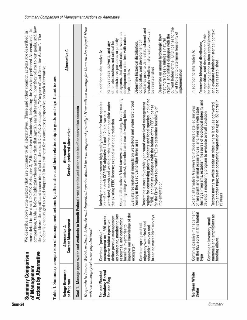
Summary Comparison of Management Actions by Alternative
Tab
le 1
. Sum
mar
y co
mpa
riso
n of
man
agem
ent
acti
ons
by a
lter
nati
ve a
nd t
heir
rel
atio
nshi
p to
goa
ls a
nd s
igni
fica
nt is
sues
Refu
ge R
esou
rce
or P
rogr
amA
ltern
ativ
e A
Curr
ent M
anag
emen
tA
ltern
ativ
e B
Serv
ice-
pref
erre
d al
tern
ativ
eA
ltern
ativ
e C
Goa
l 1.
Man
age
open
wat
er a
nd w
etla
nds
to b
enefi
t Fe
dera
l tru
st s
peci
es a
nd o
ther
spe
cies
of c
onse
rvat
ion
conc
ern
Res
pond
s to
Iss
ues:
Whi
ch w
etla
nds
habi
tats
and
dep
ende
nt s
peci
es s
houl
d be
a m
anag
emen
t pri
orit
y? H
ow w
ill w
e m
anag
e fo
r th
em o
n th
e re
fuge
? H
ow
wil
l we
man
age
furb
eare
r po
pula
tion
s?
Fen
and
Floo
ded
Mea
dow
; Bor
eal
Fen
and
Bog
Cont
inue
“pa
ssiv
e”
man
agem
ent o
n 1,
666
acre
s of
thes
e ha
bita
t typ
es; w
e de
fi ne
pass
ive
man
agem
ent
as p
rote
ctin
g, m
onito
ring
key
reso
urce
s, a
nd c
ondu
ctin
g ba
selin
e in
vent
orie
s to
im
prov
e ou
r kno
wle
dge
of th
e ec
osys
tem
Cont
inue
spr
ing
and
fall
mig
rato
ry w
ater
fow
l and
sh
oreb
ird s
urve
ys a
nd
bree
ding
mar
sh b
ird s
urve
ys
Activ
ely
man
age
to p
rom
ote
high
qua
lity
habi
tat f
or fo
cal s
peci
es
iden
tifi e
d in
dra
ft CC
P/EI
S ob
ject
ive
1.1
and
1.2
(e.g
. var
ious
w
ater
fow
l, m
arsh
and
wad
ing
bird
s), t
o th
e ex
tent
pos
sibl
e un
der
the
exis
ting
FERC
lice
nse;
exp
and
wild
rice
pro
duct
ion
Expa
nd a
ltern
ativ
e A
bird
sur
veys
to in
clud
e ne
stin
g, b
rood
-rea
ring
and
mig
ratin
g w
ater
fow
l, sh
oreb
ird a
nd m
arsh
wad
ing
bird
s
Eval
uate
recr
eatio
nal i
mpa
cts
on w
ater
fow
l and
wat
er b
ird b
rood
re
arin
g in
the
Dead
Cam
brid
ge R
iver
are
a
Dete
rmin
e a
mor
e fa
vora
ble
year
roun
d w
ater
leve
l man
agem
ent
regi
me
for c
onse
rvin
g pr
iorit
y ha
bita
ts a
nd fo
cal s
peci
es, i
nclu
ding
FI
NN
L, a
nd in
itiat
e di
alog
ue w
ith th
e ho
lder
of t
he F
ERC
licen
se
for t
he E
rrol
Pro
ject
(cur
rent
ly F
PLE)
to d
eter
min
e fe
asib
ility
of
impl
emen
tatio
n
In a
dditi
on to
alte
rnat
ive
A:
Rem
ove
road
s, c
ulve
rts, a
nd a
ny
othe
r obs
truct
ions
not
crit
ical
for
adm
inis
trativ
e pu
rpos
es o
r prio
rity
prog
ram
s, th
at a
ffect
nat
ural
wet
land
s de
velo
pmen
t or i
nter
fere
with
nat
ural
hy
drol
ogic
fl ow
Dete
rmin
e hi
stor
ical
dis
tribu
tion,
co
mpo
sitio
n, a
nd d
evel
opm
ent o
f w
etla
nds
prio
r to
dam
est
ablis
hmen
t and
ev
alua
te w
heth
er h
isto
rical
con
text
can
be
rees
tabl
ishe
d
Dete
rmin
e an
ann
ual h
ydro
logi
c fl o
w
that
mor
e cl
osel
y m
imic
s a
natu
ral
regi
me,
and
initi
ate
dial
ogue
with
the
curr
ent h
olde
r of t
he F
ERC
licen
se fo
r the
Er
rol P
roje
ct to
det
erm
ine
feas
ibili
ty o
f im
plem
enta
tion
Nor
ther
n W
hite
Ce
dar
Cont
inue
pas
sive
man
agem
ent
on th
e 82
9 ac
res
in th
is h
abita
t ty
pe
Cont
inue
to in
vent
ory
smal
l m
amm
als
and
amph
ibia
ns a
s fu
ndin
g al
low
s
Expa
nd a
ltern
ativ
e A
surv
eys
to in
clud
e m
ore
deta
iled
surv
eys
of ra
re p
lant
and
ani
mal
occ
urre
nces
; and
, wor
king
with
sta
te
Herit
age
Prog
ram
s, e
stab
lish
mea
sure
s of
eco
logi
cal i
nteg
rity
and
deve
lop
a m
onito
ring
prog
ram
to e
valu
ate
over
all c
ondi
tion
Rest
ore
north
ern
whi
te c
edar
on
site
s w
here
land
use
con
verte
d it
to a
noth
er ty
pe; t
reat
com
petin
g ve
geta
tion
on u
p to
150
acr
es in
15
yea
rs
In a
dditi
on to
alte
rnat
ive
A:
Dete
rmin
e hi
stor
ical
dis
tribu
tion,
co
mpo
sitio
n, a
nd d
evel
opm
ent o
f thi
s ha
bita
t typ
e pr
ior t
o da
m e
stab
lishm
ent
and
eval
uate
whe
ther
his
toric
al c
onte
xt
can
be re
esta
blis
hed
W
e de
scri
be a
bove
som
e ac
tion
s th
at a
re c
omm
on t
o al
l alt
erna
tive
s. T
hese
and
oth
er c
omm
on a
ctio
ns a
re d
escr
ibed
in
mor
e de
tail
in t
he d
raft
CC
P/E
IS c
hapt
er 2
, “A
lter
nati
ves
Con
side
red,
Inc
ludi
ng t
he S
ervi
ce-p
refe
rred
Alt
erna
tive
”. I
n co
mpa
riso
n, t
able
1 b
elow
hig
hlig
hts
thos
e ac
tion
s th
at d
isti
ngui
sh e
ach
alte
rnat
ive,
how
the
y re
late
to
our
goal
s, a
nd h
ow
they
add
ress
the
sig
nifi
cant
issu
es id
enti
fied
in t
he d
raft
CC
P/E
IS c
hapt
er 1
, “P
urpo
se o
f and
Nee
d fo
r A
ctio
n”.
The
re
ader
is e
ncou
rage
d to
rea
d ch
apte
r 2
in it
s en
tire
ty fo
r a
com
plet
e pe
rspe
ctiv
e on
eac
h al
tern
ativ
e.
Sum
mar
y Co
mpa
rison
of
Man
agem
ent
Actio
ns b
y Al
tern
ativ
e
Sum
mar
y Co
mpa
rison
of
Man
agem
ent
Actio
ns b
y Al
tern
ativ
e

Summary Sum-25
Summary Comparison of Management Actions by Alternative
Refu
ge R
esou
rce
or P
rogr
amA
ltern
ativ
e A
Curr
ent M
anag
emen
tA
ltern
ativ
e B
Serv
ice-
pref
erre
d al
tern
ativ
eA
ltern
ativ
e C
Goa
l 1. (
cont
’d)
Man
age
open
wat
er a
nd w
etla
nds
to b
enefi
t Fe
dera
l tru
st s
peci
es a
nd o
ther
spe
cies
of c
onse
rvat
ion
conc
ern
Nor
ther
n W
hite
Ce
dar (
cont
’d)
Eval
uate
hab
itat n
eeds
of b
orea
l spe
cies
usi
ng th
is h
abita
t typ
e;
man
age
to e
nhan
ce th
ose
feat
ures
, if n
ot p
rese
ntW
ork
with
sta
te h
erita
ge p
rogr
ams
to,
cond
uct b
asel
ine
stud
ies
of ra
re p
lant
an
d an
imal
occ
urre
nces
, est
ablis
h m
easu
res
of e
colo
gica
l int
egrit
y an
d de
velo
p a
mon
itorin
g pr
ogra
m
Scru
b-Sh
rub
Cont
inue
pas
sive
man
agem
ent
on th
e 65
5 ac
res
in th
is h
abita
t ty
pe
In w
oodc
ock
focu
s ar
eas,
iden
tify
treat
men
t uni
ts a
nd a
ctiv
ely
enha
nce
habi
tat t
o ju
xtap
ose
fora
ging
, roo
stin
g, c
ourts
hip,
ne
stin
g an
d br
ood
cove
r; e.
g. p
rom
ote
alde
r, cr
eate
ope
ning
s, a
nd
enco
urag
e be
aver
In a
dditi
on a
ltern
ativ
e A:
Use
beav
er to
sus
tain
this
hab
itat t
ype;
m
anag
e be
aver
pop
ulat
ions
with
in th
eir
hist
oric
, nat
ural
rang
e of
den
sity
/mile
fo
und
in s
uita
ble
habi
tat i
n no
rther
n N
H an
d M
E
Ope
n W
ater
Cont
inue
pas
sive
man
agem
ent
on th
e 5,
033
acre
s in
this
ha
bita
t typ
e
Wor
k w
ith s
tate
s, to
pro
tect
and
enh
ance
SAV
bed
s, im
prov
e w
ater
qua
lity,
and
incr
ease
pro
duct
ion
of n
ativ
e br
ook
trout
Sa
me
as a
ltern
ativ
e A
Com
mon
Loo
n Co
ntin
ue to
mon
itor a
nd
prot
ect l
oon
nest
ing
site
s (e
.g. r
estri
ct p
ublic
acc
ess,
bu
oy li
nes,
nes
t obs
erve
rs
and
mon
itors
, out
reac
h an
d ed
ucat
ion)
in p
artn
ersh
ip
with
sta
tes
and
the
hold
er o
f th
e FE
RC li
cens
e fo
r the
Err
ol
Proj
ect (
curr
ently
FPL
E)
Cont
inue
to s
uppo
rt re
sear
ch
into
the
decl
ine
of th
e lo
cal
loon
pop
ulat
ion.
In a
dditi
on to
alte
rnat
ive
A, in
itiat
e su
rvey
s an
d st
udie
s to
:
Map
and
mon
itor r
ecre
atio
nal u
se a
nd p
ress
ure
near
loon
nes
ting
terr
itorie
s
Eval
uate
loon
inte
ract
ions
with
wat
erfo
wl d
urin
g th
e br
eedi
ng
seas
on a
nd d
eter
min
e im
pact
of p
reda
tors
in lo
on n
estin
g su
cces
s;
man
age
loon
pre
dato
rs a
s w
arra
nted
Eval
uate
ava
ilabi
lity
and
qual
ity o
f nat
ural
nes
ting
site
s
Sam
e as
alte
rnat
ive
A
Furb
eare
r M
anag
emen
tN
o m
anag
emen
tAt
refu
ge m
anag
er’s
disc
retio
n, u
se tr
appi
ng a
s a
furb
eare
r m
anag
emen
t too
l to
achi
eve
obje
ctiv
es.
Sam
e as
alte
rnat
ive
B; a
lthou
gh
furb
eare
r tra
ppin
g le
ss li
kely
to b
e ut
ilize
d un
der t
his
scen
ario
SummarySum-26
Summary Comparison of Management Actions by Alternative
Refu
ge R
esou
rce
or P
rogr
amA
ltern
ativ
e A
Curr
ent M
anag
emen
tA
ltern
ativ
e B
Serv
ice-
pref
erre
d al
tern
ativ
eA
ltern
ativ
e C
Goa
l 2.
Man
age
fl ood
plai
n an
d la
kesh
ore
habi
tats
to b
enefi
t Fe
dera
l tru
st s
peci
es a
nd o
ther
spe
cies
of c
onse
rvat
ion
conc
ern
Res
pond
s to
Iss
ue: W
hich
hab
itat
s an
d de
pend
ent s
peci
es s
houl
d be
a m
anag
emen
t pri
orit
y? H
ow w
ill w
e m
anag
e fo
r th
em o
n th
e re
fuge
?
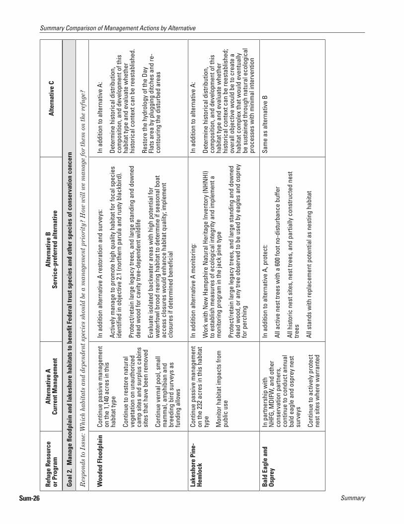
Woo
ded
Floo
dpla
in
Cont
inue
pas
sive
man
agem
ent
on th
e 1,
140
acre
s in
this
ha
bita
t typ
e
Cont
inue
to re
stor
e na
tura
l ve
geta
tion
on u
naut
horiz
ed
cam
p si
tes
and
surp
lus
cabi
ns
site
s th
at h
ave
been
rem
oved
Cont
inue
ver
nal p
ool,
smal
l m
amm
al, a
mph
ibia
n an
d br
eedi
ng b
ird s
urve
ys a
s fu
ndin
g al
low
s
In a
dditi
on a
ltern
ativ
e A
rest
orat
ion
and
surv
eys:
Activ
ely
man
age
to p
rom
ote
high
qua
lity
habi
tat f
or fo
cal s
peci
es
iden
tifi e
d in
obj
ectiv
e 2.
1 (n
orth
ern
paru
la a
nd ru
sty
blac
kbird
).
Prot
ect/r
etai
n la
rge
lega
cy tr
ees,
and
larg
e st
andi
ng a
nd d
owne
d de
ad w
ood
for c
avity
tree
-dep
ende
nt w
ildlif
e
Eval
uate
isol
ated
bac
kwat
er a
reas
with
hig
h po
tent
ial f
or
wat
erfo
wl b
rood
rear
ing
habi
tat t
o de
term
ine
if se
ason
al b
oat
acce
ss c
losu
res
wou
ld e
nhan
ce h
abita
t qua
lity;
impl
emen
t cl
osur
es if
det
erm
ined
ben
efi c
ial
In a
dditi
on to
alte
rnat
ive
A:
Dete
rmin
e hi
stor
ical
dis
tribu
tion,
co
mpo
sitio
n, a
nd d
evel
opm
ent o
f thi
s ha
bita
t typ
e an
d ev
alua
te w
heth
er
hist
oric
al c
onte
xt c
an b
e re
esta
blis
hed.
Rest
ore
the
hydr
olog
y of
the
Day
Flat
s ar
ea b
y pl
uggi
ng d
itche
s an
d re
-co
ntou
ring
the
dist
urbe
d ar
eas
Lake
shor
e Pi
ne-
Hem
lock
Cont
inue
pas
sive
man
agem
ent
on th
e 23
2 ac
res
in th
is h
abita
t ty
pe
Mon
itor h
abita
t im
pact
s fro
m
publ
ic u
se
In a
dditi
on a
ltern
ativ
e A
mon
itorin
g:
Wor
k w
ith N
ew H
amps
hire
Nat
ural
Her
itage
Inve
ntor
y (N
HNHI
) to
est
ablis
h m
easu
res
of e
colo
gica
l int
egrit
y an
d im
plem
ent a
m
onito
ring
prog
ram
in th
e ja
ck p
ine
type
Prot
ect/r
etai
n la
rge
lega
cy tr
ees,
and
larg
e st
andi
ng a
nd d
owne
d de
ad w
ood,
or a
ny tr
ee o
bser
ved
to b
e us
ed b
y ea
gles
and
osp
rey
for p
erch
ing
In a
dditi
on to
alte
rnat
ive
A:
Dete
rmin
e hi
stor
ical
dis
tribu
tion,
co
mpo
sitio
n, a
nd d
evel
opm
ent o
f thi
s ha
bita
t typ
e an
d ev
alua
te w
heth
er
hist
oric
al c
onte
xt c
an b
e re
esta
blis
hed;
ov
eral
l obj
ectiv
e w
ould
be
to c
reat
e a
habi
tat c
ompl
ex th
at w
ould
eve
ntua
lly
be s
usta
ined
thro
ugh
natu
ral e
colo
gica
l pr
oces
ses
with
min
imal
inte
rven
tion
Bal
d Ea
gle
and
Osp
rey
In p
artn
ersh
ip w
ith
NHF
G, M
DIFW
, and
oth
er
cons
erva
tion
partn
ers,
co
ntin
ue to
con
duct
ann
ual
bald
eag
le a
nd o
spre
y ne
st
surv
eys
Cont
inue
to a
ctiv
ely
prot
ect
nest
site
s w
here
war
rant
ed
In a
dditi
on to
alte
rnat
ive
A, p
rote
ct:
All a
ctiv
e ne
st tr
ees
with
a 6
00 fo
ot n
o-di
stur
banc
e bu
ffer
All h
isto
ric n
est s
ites,
nes
t tre
es, a
nd p
artia
lly c
onst
ruct
ed n
est
trees
All s
tand
s w
ith re
plac
emen
t pot
entia
l as
nest
ing
habi
tat
Sam
e as
alte
rnat
ive
B

Summary Sum-27
Summary Comparison of Management Actions by Alternative
Refu
ge R
esou
rce
or P
rogr
amA
ltern
ativ
e A
Curr
ent M
anag
emen
tA
ltern
ativ
e B
Serv
ice-
pref
erre
d al
tern
ativ
eA
ltern
ativ
e C
Goa
l 3.
Man
age
upla
nd fo
rest
ed h
abita
ts, c
onsi
sten
t with
site
cap
abili
ties,
to b
enefi
t Fe
dera
l tru
st s
peci
es a
nd o
ther
spe
cies
of c
onse
rvat
ion
conc
ern
Res
pond
s to
Iss
ues:
Whi
ch u
plan
d fo
rest
hab
itat
s an
d fo
rest
-dep
ende
nt s
peci
es s
houl
d be
a m
anag
emen
t pri
orit
y? H
ow w
ill w
e m
anag
e fo
r th
em o
n th
e re
fuge
?
Mix
ed F
ores
t M
atri
x
With
3 e
mbe
dded
ha
bita
t typ
es:
1) S
pruc
e-Fi
r2)
Mix
ed W
oods
3)
Nor
ther
n H
ardw
ood
Cont
inue
pas
sive
man
agem
ent
on th
e 9,
913
acre
s in
this
ha
bita
t typ
e
Cont
inue
to w
ork
with
NHF
G an
d M
DIFW
to id
entif
y an
d pr
otec
t all
deer
win
ter y
ards
Cont
inue
to c
ondu
ct a
nnua
l br
eedi
ng b
ird s
urve
ys
Activ
ely
man
age
to p
rom
ote
and
sust
ain
high
qua
lity
habi
tat f
or
refu
ge fo
cal s
peci
es id
entifi
ed
in o
bjec
tive
3.1
(e.g
. bla
ckbu
rnia
n,
Cana
da, a
nd b
lack
-thro
ated
gre
en w
arbl
ers,
and
Am
eric
an
woo
dcoc
k); m
anag
e fo
r a d
iver
sity
of a
ge a
nd s
truct
ural
cla
sses
Cont
inue
to c
ondu
ct a
ltern
ativ
e A
bree
ding
bird
sur
veys
.
Wor
k w
ith ly
nx re
cove
ry te
am to
det
erm
ine
any
futu
re
man
agem
ent p
oten
tial
Man
age
mix
ed fo
rest
mat
rix d
evel
opm
ent
acro
ss th
e re
fuge
land
scap
e to
ap
prox
imat
e th
e na
tive
spec
ies
and
the
ecol
ogic
al p
roce
sses
, inc
ludi
ng n
atur
al
dist
urba
nce
regi
me,
cha
ract
eris
tic o
f the
m
ixed
fore
st m
atrix
with
in th
eir n
atur
al
rang
e of
var
iatio
n.
Goa
l 4.
Prov
ide
high
qua
lity
wild
life-
depe
nden
t act
iviti
es s
uch
as h
untin
g, fi
shin
g, w
ildlif
e ob
serv
atio
n, a
nd p
hoto
grap
hy
Res
pond
s to
Iss
ues:
Wha
t is
the
appr
opri
ate
leve
l of u
se fo
r ea
ch o
f the
six
pri
orit
y pu
blic
use
pro
gram
s on
the
refu
ge: h
unti
ng, fi
shi
ng, w
ildl
ife
obse
rvat
ion
and
phot
ogra
phy,
env
iron
men
tal e
duca
tion
and
inte
rpre
tati
on?
Wha
t mea
ns o
f acc
ess
wil
l we
allo
w fo
r th
ese
acti
viti
es?
How
wil
l we
man
age
rem
ote
cam
ping
on
the
refu
ge?
Hun
ting
Cont
inue
to o
ffer a
hun
t pr
ogra
m.
Cont
inue
to m
aint
ain
6 w
ater
fow
l hun
t blin
ds a
nd
allo
w u
se u
nder
a re
serv
atio
n sy
stem
In a
dditi
on to
alte
rnat
ive
A:
Impr
ove
info
rmat
ion
mat
eria
ls p
rovi
ded
to h
unte
rs (e
.g. a
llow
ed
acce
ss, o
ther
rest
rictio
ns)
Incr
ease
kno
wle
dge
of re
fuge
har
vest
info
rmat
ion
and
hunt
er
satis
fact
ion.
With
in 1
yea
r of C
CP a
ppro
val,
initi
ate
adm
inis
trativ
e pr
oces
s,
incl
udin
g ad
ditio
nal N
EPA
anal
ysis
and
pub
lic in
volv
emen
t op
portu
nitie
s to
ope
n th
e re
fuge
to 2
new
hun
ting
seas
ons.
Esta
blis
h hu
ntin
g un
its a
nd d
istri
bute
use
an
d lim
it nu
mbe
rs th
roug
h fre
e sp
ecia
l us
e pe
rmit
prog
ram
;
No
new
dev
elop
men
ts, f
acili
ties,
or
impr
oved
acc
ess
wou
ld b
e pr
ovid
ed;
maj
ority
of a
rea
is w
alk-
in u
se o
nly
Fish
ing
Cont
inue
to a
llow
fi sh
ing.
Cont
inue
to h
ost T
ake
Me
Fish
ing
even
t
In a
dditi
on to
alte
rnat
ive
A:
Com
plet
e al
l adm
inis
trativ
e ac
tions
to o
ffi ci
ally
ope
n th
e re
fuge
to
fi shi
ng
Prov
ide
impr
oved
lake
and
rive
r sho
relin
e ac
cess
at d
esig
nate
d si
tes,
and
new
pro
pose
d si
tes.
Wor
k w
ith N
HFG
and
MDI
FW to
mai
ntai
n hi
gh q
ualit
y br
ook
trout
fi s
hery
in th
e Ra
pid,
Dea
d Di
amon
d, a
nd D
ead
Cam
brid
ge ri
vers
Sam
e as
alte
rnat
ive
B, e
xcep
t the
ob
ject
ive
is to
pro
mot
e a
rem
ote,
low
de
nsity
ang
ling
expe
rienc
e. A
ctio
ns th
at
wou
ld d
iffer
incl
ude:
Cons
ider
per
mit
syst
em o
nce
thre
shol
ds
have
bee
n br
each
ed
No
new
dev
elop
men
ts, f
acili
ties,
or
impr
oved
acc
ess
wou
ld b
e pr
ovid
ed;
maj
ority
of a
rea
is w
alk-
in u
se o
nly
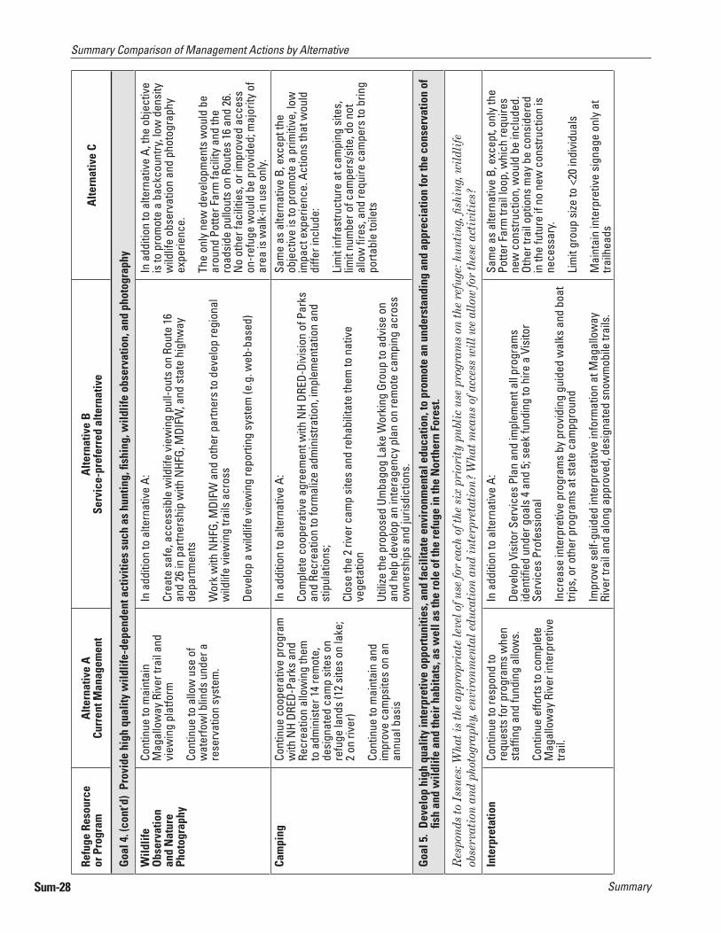
SummarySum-28
Summary Comparison of Management Actions by Alternative
Refu
ge R
esou
rce
or P
rogr
amA
ltern
ativ
e A
Curr
ent M
anag
emen
tA
ltern
ativ
e B
Serv
ice-
pref
erre
d al
tern
ativ
eA
ltern
ativ
e C
Goa
l 4. (
cont
’d)
Prov
ide
high
qua
lity
wild
life-
depe
nden
t act
iviti
es s
uch
as h
untin
g, fi
shin
g, w
ildlif
e ob
serv
atio
n, a
nd p
hoto
grap
hy
Wild
life
Obs
erva
tion
and
Nat
ure
Phot
ogra
phy
Cont
inue
to m
aint
ain
Mag
allo
way
Riv
er tr
ail a
nd
view
ing
plat
form
Cont
inue
to a
llow
use
of
wat
erfo
wl b
linds
und
er a
re
serv
atio
n sy
stem
.
In a
dditi
on to
alte
rnat
ive
A:
Crea
te s
afe,
acc
essi
ble
wild
life
view
ing
pull-
outs
on
Rout
e 16
an
d 26
in p
artn
ersh
ip w
ith N
HFG,
MDI
FW, a
nd s
tate
hig
hway
de
partm
ents
Wor
k w
ith N
HFG,
MDI
FW a
nd o
ther
par
tner
s to
dev
elop
regi
onal
w
ildlif
e vi
ewin
g tra
ils a
cros
s
Deve
lop
a w
ildlif
e vi
ewin
g re
porti
ng s
yste
m (e
.g. w
eb-b
ased
)
In a
dditi
on to
alte
rnat
ive
A, th
e ob
ject
ive
is to
pro
mot
e a
back
coun
try, l
ow d
ensi
ty
wild
life
obse
rvat
ion
and
phot
ogra
phy
expe
rienc
e.
The
only
new
dev
elop
men
ts w
ould
be
arou
nd P
otte
r Far
m fa
cilit
y an
d th
e ro
adsi
de p
ullo
uts
on R
oute
s 16
and
26.
N
o ot
her f
acili
ties,
or i
mpr
oved
acc
ess
on-r
efug
e w
ould
be
prov
ided
; maj
ority
of
area
is w
alk-
in u
se o
nly.
Cam
ping
Cont
inue
coo
pera
tive
prog
ram
w
ith N
H DR
ED-P
arks
and
Re
crea
tion
allo
win
g th
em
to a
dmin
iste
r 14
rem
ote,
de
sign
ated
cam
p si
tes
on
refu
ge la
nds
(12
site
s on
lake
; 2
on ri
ver)
Cont
inue
to m
aint
ain
and
impr
ove
cam
psite
s on
an
annu
al b
asis
In a
dditi
on to
alte
rnat
ive
A:
Com
plet
e co
oper
ativ
e ag
reem
ent w
ith N
H DR
ED-D
ivis
ion
of P
arks
an
d Re
crea
tion
to fo
rmal
ize a
dmin
istra
tion,
impl
emen
tatio
n an
d st
ipul
atio
ns;
Clos
e th
e 2
river
cam
p si
tes
and
reha
bilit
ate
them
to n
ativ
e ve
geta
tion
Utili
ze th
e pr
opos
ed U
mba
gog
Lake
Wor
king
Gro
up to
adv
ise
on
and
help
dev
elop
an
inte
rage
ncy
plan
on
rem
ote
cam
ping
acr
oss
owne
rshi
ps a
nd ju
risdi
ctio
ns.
Sam
e as
alte
rnat
ive
B, e
xcep
t the
ob
ject
ive
is to
pro
mot
e a
prim
itive
, low
im
pact
exp
erie
nce.
Act
ions
that
wou
ld
diffe
r inc
lude
:
Lim
it in
frast
ruct
ure
at c
ampi
ng s
ites,
lim
it nu
mbe
r of c
ampe
rs/s
ite, d
o no
t al
low
fi re
s, a
nd re
quire
cam
pers
to b
ring
porta
ble
toile
ts
Goa
l 5.
Dev
elop
hig
h qu
ality
inte
rpre
tive
oppo
rtun
ities
, and
faci
litat
e en
viro
nmen
tal e
duca
tion,
to p
rom
ote
an u
nder
stan
ding
and
app
reci
atio
n fo
r the
con
serv
atio
n of
fi s
h an
d w
ildlif
e an
d th
eir h
abita
ts, a
s w
ell a
s th
e ro
le o
f the
refu
ge in
the
Nor
ther
n Fo
rest
.
Res
pond
s to
Iss
ues:
Wha
t is
the
appr
opri
ate
leve
l of u
se fo
r ea
ch o
f the
six
pri
orit
y pu
blic
use
pro
gram
s on
the
refu
ge: h
unti
ng, fi
shi
ng, w
ildl
ife
obse
rvat
ion
and
phot
ogra
phy,
env
iron
men
tal e
duca
tion
and
inte
rpre
tati
on?
Wha
t mea
ns o
f acc
ess
wil
l we
allo
w fo
r th
ese
acti
viti
es?
Inte
rpre
tatio
n Co
ntin
ue to
resp
ond
to
requ
ests
for p
rogr
ams
whe
n st
affi n
g an
d fu
ndin
g al
low
s.
Cont
inue
effo
rts to
com
plet
e M
agal
low
ay R
iver
inte
rpre
tive
trail.
In a
dditi
on to
alte
rnat
ive
A:
Deve
lop
Visi
tor S
ervi
ces
Plan
and
impl
emen
t all
prog
ram
s id
entifi
ed
unde
r goa
ls 4
and
5; s
eek
fund
ing
to h
ire a
Vis
itor
Serv
ices
Pro
fess
iona
l
Incr
ease
inte
rpre
tive
prog
ram
s by
pro
vidi
ng g
uide
d w
alks
and
boa
t tri
ps, o
r oth
er p
rogr
ams
at s
tate
cam
pgro
und
Impr
ove
self-
guid
ed in
terp
reta
tive
info
rmat
ion
at M
agal
low
ay
Rive
r tra
il an
d al
ong
appr
oved
, des
igna
ted
snow
mob
ile tr
ails
.
Sam
e as
alte
rnat
ive
B, e
xcep
t, on
ly th
e Po
tter F
arm
trai
l loo
p, w
hich
requ
ires
new
con
stru
ctio
n, w
ould
be
incl
uded
. Ot
her t
rail
optio
ns m
ay b
e co
nsid
ered
in
the
futu
re if
no
new
con
stru
ctio
n is
ne
cess
ary.
Lim
it gr
oup
size
to <
20 in
divi
dual
s
Mai
ntai
n in
terp
retiv
e si
gnag
e on
ly a
t tra
ilhea
ds

Summary Sum-29
Summary Comparison of Management Actions by Alternative
Refu
ge R
esou
rce
or P
rogr
amA
ltern
ativ
e A
Curr
ent M
anag
emen
tA
ltern
ativ
e B
Serv
ice-
pref
erre
d al
tern
ativ
eA
ltern
ativ
e C
Goa
l 5. (
cont
’d)
Dev
elop
hig
h qu
ality
inte
rpre
tive
oppo
rtun
ities
, and
faci
litat
e en
viro
nmen
tal e
duca
tion,
to p
rom
ote
an u
nder
stan
ding
and
app
reci
atio
n fo
r the
co
nser
vatio
n of
fi sh
and
wild
life
and
thei
r hab
itats
, as
wel
l as
the
role
of t
he re
fuge
in th
e N
orth
ern
Fore
st.
Com
mun
ityO
utre
ach
Cont
inue
to c
oord
inat
e tw
o an
nual
com
mun
ity e
vent
s:
Umba
gog
Wild
life
Fest
ival
, and
Ta
ke M
e Fi
shin
g.
Cont
inue
to d
istri
bute
br
ochu
res
and
liter
atur
e on
im
pact
s to
wild
life
from
lead
fi s
hing
tack
le
In a
dditi
on to
alte
rnat
ive
A:
Crea
te n
ew, a
nd im
prov
e ex
istin
g ou
treac
h m
ater
ials
(new
slet
ter,
web
site
, med
ia a
nd p
ress
kits
, fac
t she
ets,
virt
ual t
ours
of r
efug
e an
d w
ebca
ms
at b
ald
eagl
e an
d lo
on n
estin
g si
tes)
Coor
dina
te w
ith s
tate
s an
d Um
bago
g La
ke W
orki
ng G
roup
to
deve
lop
lake
acc
ess
man
agem
ent p
lan
and
outre
ach
mat
eria
ls.
Cond
uct o
utre
ach
targ
eted
at r
efug
e ne
ighb
ors
to e
ncou
rage
thei
r aw
aren
ess,
inte
rest
and
invo
lvem
ent i
n re
fuge
act
iviti
es.
Sam
e as
alte
rnat
ive
B
Envi
ronm
enta
l Ed
ucat
ion
No
curr
ent p
rogr
amFa
cilit
ate
partn
er-le
d ed
ucat
iona
l pro
gram
dev
elop
men
t and
im
plem
enta
tion
on th
e re
fuge
; ref
uge
staf
f and
reso
urce
s w
ould
be
limite
d
Eval
uate
pot
entia
l for
adu
lt ed
ucat
iona
l par
tner
ship
s th
roug
h un
iver
sitie
s or
pro
gram
s su
ch a
s El
der H
oste
l
Sam
e as
alte
rnat
ive
B
Goa
l 6.
Enha
nce
the
cons
erva
tion
and
man
agem
ent o
f fi s
h an
d w
ildlif
e re
sour
ces
in th
e N
orth
ern
Fore
st R
egio
n th
roug
h pa
rtne
rshi
ps w
ith p
ublic
and
pri
vate
co
nser
vatio
n gr
oups
, pri
vate
land
owne
rs, S
tate
and
loca
l ent
ities
Res
pond
s to
Iss
ues:
Wha
t sho
uld
be th
e re
fuge
’s r
ole
in la
nd c
onse
rvat
ion
effo
rts
in th
e U
pper
And
rosc
oggi
n R
iver
wat
ersh
ed?
Shou
ld w
e pu
rsue
a r
efug
e ex
pans
ion?
How
can
the
refu
ge a
nd it
s st
aff b
e an
ass
et to
loca
l com
mun
itie
s an
d su
ppor
t the
ir r
espe
ctiv
e vi
sion
and
goa
ls fo
r th
e ar
ea?
Land
Con
serv
atio
n an
d Pr
otec
tion
Cont
inue
to p
artic
ipat
e in
re
gion
al la
nd c
onse
rvat
ion
partn
ersh
ips
Cont
inue
to a
cqui
re 6
,392
to
tal a
cres
of h
igh
prio
rity
habi
tat f
rom
will
ing
selle
rs
with
in th
e cu
rren
t, ap
prov
ed
refu
ge. A
cres
are
del
inea
ted
by re
spec
tive
habi
tat t
ype
in
chap
ter 2
of t
he d
raft
CCP/
EIS.
In a
dditi
on to
acq
uisi
tion
prio
ritie
s un
der a
ltern
ativ
e A,
incr
ease
th
e Se
rvic
e’s
cont
ribut
ion
to c
onse
rvin
g si
gnifi
cant
hab
itats
and
sp
ecie
s of
con
serv
atio
n co
ncer
n th
roug
h Se
rvic
e fe
e-si
mpl
e ac
quis
ition
of 3
2,15
9 ac
res
and
17,5
59 a
cres
in c
onse
rvat
ion
ease
men
ts. A
cres
pro
pose
d fo
r acq
uisi
tion
from
will
ing
selle
rs
are
delin
eate
d by
resp
ectiv
e ha
bita
t typ
e in
cha
pter
2 o
f the
dra
ft CC
P/EI
S.
In a
dditi
on to
acq
uisi
tion
prio
ritie
s un
der
alte
rnat
ive
A, in
crea
se c
ontri
butio
n to
co
nser
ving
sig
nifi c
ant h
abita
ts, n
ativ
e sp
ecie
s, a
nd th
e ec
olog
ical
pro
cess
es
char
acte
ristic
of t
he N
orth
ern
Fore
st
with
in th
eir n
atur
al ra
nges
of v
aria
tion,
th
roug
h Se
rvic
e fe
e-si
mpl
e ac
quis
ition
of
76,
304
acre
s. A
cres
pro
pose
d fo
r ac
quis
ition
from
will
ing
selle
rs a
re
delin
eate
d by
resp
ectiv
e ha
bita
t typ
e in
ch
apte
r 2 o
f the
dra
ft CC
P/EI
S.
Regi
onal
and
Co
mm
unity
Pa
rtne
rshi
ps
Cont
inue
wor
king
with
the
num
erou
s pa
rtner
s id
entifi
ed
unde
r obj
ectiv
e 6.
1 to
ad
dres
s bo
th re
gion
al (e
.g.
Nor
ther
n Fo
rest
and
Upp
er
Andr
osco
ggin
wat
ersh
ed)
and
loca
l (to
wn,
indi
vidu
al
reso
urce
or p
rogr
am) i
ssue
s an
d op
portu
nitie
s
In a
dditi
on to
alte
rnat
ive
A:
Expl
ore
the
pote
ntia
l for
a re
gion
al U
mba
gog
Area
Frie
nds
Grou
p
Parti
cipa
te in
regi
onal
and
loca
l com
mun
ity e
cono
mic
de
velo
pmen
t and
con
serv
atio
n pa
rtner
ship
s an
d in
itiat
ives
, suc
h as
Upp
er A
ndro
scog
gin
Advi
sory
Com
mitt
ee
Sam
e as
alte
rnat
ive
B

SummarySum-30
Summary Comparison of Management Actions by Alternative
Refu
ge R
esou
rce
or P
rogr
amA
ltern
ativ
e A
Curr
ent M
anag
emen
tA
ltern
ativ
e B
Serv
ice-
pref
erre
d al
tern
ativ
eA
ltern
ativ
e C
Goa
l 6. (
cont
’d)
Enha
nce
the
cons
erva
tion
and
man
agem
ent o
f fi s
h an
d w
ildlif
e re
sour
ces
in th
e N
orth
ern
Fore
st R
egio
n th
roug
h pa
rtne
rshi
ps w
ith p
ublic
and
pri
vate
co
nser
vatio
n gr
oups
, pri
vate
land
owne
rs, S
tate
and
loca
l ent
ities
Coop
erat
ive
Man
agem
en t o
f U
mba
gog
Lake
Not
hing
form
al e
stab
lishe
d,
but c
ontin
ue to
wor
k w
ith
NHF
G an
d M
DIFW
to c
ondu
ct
boat
er a
nd a
ngle
r saf
ety
and
ethi
cs o
utre
ach
durin
g fe
stiv
als
and
indi
vidu
al v
isito
r co
ntac
ts
In a
dditi
on to
alte
rnat
ive
A:
Prom
ote
the
esta
blis
hmen
t of a
n in
tera
genc
y, in
ter-
juris
dict
iona
l Um
bago
g La
ke W
orki
ng G
roup
to d
evel
op v
olun
tary
bes
t m
anag
emen
t pra
ctic
es, a
nd to
add
ress
use
r and
reso
urce
issu
es
that
cro
ss o
wne
rshi
ps
Sam
e as
alte
rnat
ive
B
Part
ner-
man
aged
Vi
sito
r Fac
ilitie
sN
one
With
loca
l bus
ines
s an
d to
wn
offi c
ials
and
sta
te p
artn
ers,
dev
elop
a
visi
tor c
onta
ct fa
cilit
y in
Err
ol to
orie
nt v
isito
rs to
the
Umba
gog
regi
on
Sam
e as
alte
rnat
ive
B
Goa
l 7.
Dev
elop
Um
bago
g N
atio
nal W
ildlif
e Re
fuge
as
an o
utst
andi
ng c
ente
r for
rese
arch
and
dev
elop
men
t of a
pplie
d m
anag
emen
t pra
ctic
es to
sus
tain
and
enh
ance
th
e na
tura
l res
ourc
es in
the
Nor
ther
n Fo
rest
in c
once
rt w
ith th
e La
nd M
anag
emen
t Res
earc
h D
emon
stra
tion
(LM
RD) P
rogr
am
Rese
arch
an
d A
pplie
d M
anag
emen
t
No
prog
ram
Seek
sup
port
and
fund
ing
to e
stab
lish
the
refu
ge a
s an
LM
RD s
ite;
hire
an
LMRD
coo
rdin
ator
to fa
cilit
ate
impl
emen
tatio
n
Cond
uct a
rese
arch
nee
ds a
sses
smen
t for
the
refu
ge
Sam
e as
alte
rnat
ive
B, e
xcep
t pro
gram
em
phas
is is
on
natu
ral l
ands
cape
co
mpo
sitio
n, p
atte
rns,
and
pro
cess
es
Out
reac
h fo
r Re
sear
ch a
nd
Man
agem
ent
Prog
ram
s
Non
eFa
cilit
ate
dem
onst
ratio
n ar
ea o
n-re
fuge
, and
on
othe
r co
nser
vatio
n ow
ners
hips
, tha
t sho
wca
se a
pplie
d m
anag
emen
t to
bene
fi t n
atur
al re
sour
ces
Coop
erat
e w
ith P
artn
ers
for W
ildlif
e pr
ogra
m to
acc
ompl
ish
outre
ach,
dem
onst
ratio
n pr
ojec
ts, a
nd s
eek
fund
ing
Cond
uct w
orks
hops
, cou
rses
, and
oth
er te
chni
cal f
orum
s
Publ
ish
rese
arch
fi nd
ings
in p
eer-
revi
ewed
pub
licat
ions
Sam
e as
alte
rnat
ive
B
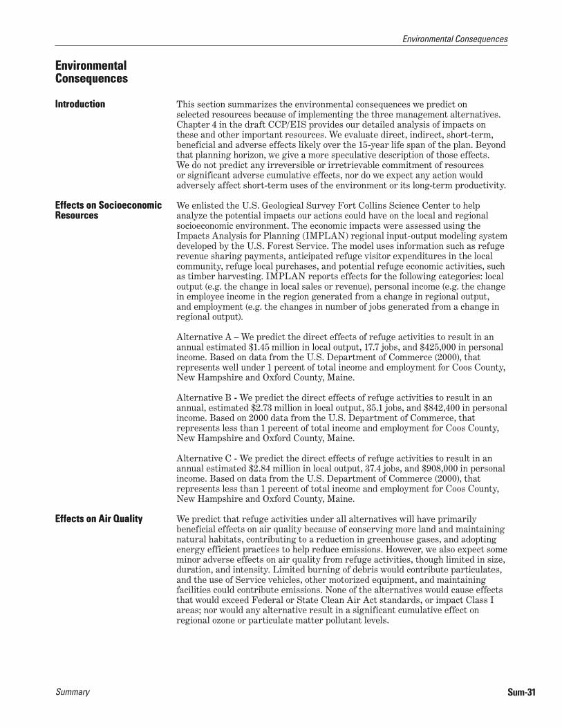
Environmental Consequences
Summary Sum-31
This section summarizes the environmental consequences we predict on selected resources because of implementing the three management alternatives. Chapter 4 in the draft CCP/EIS provides our detailed analysis of impacts on these and other important resources. We evaluate direct, indirect, short-term, beneficial and adverse effects likely over the 15-year life span of the plan. Beyond that planning horizon, we give a more speculative description of those effects. We do not predict any irreversible or irretrievable commitment of resources or significant adverse cumulative effects, nor do we expect any action would adversely affect short-term uses of the environment or its long-term productivity.
We enlisted the U.S. Geological Survey Fort Collins Science Center to help analyze the potential impacts our actions could have on the local and regional socioeconomic environment. The economic impacts were assessed using the Impacts Analysis for Planning (IMPLAN) regional input-output modeling system developed by the U.S. Forest Service. The model uses information such as refuge revenue sharing payments, anticipated refuge visitor expenditures in the local community, refuge local purchases, and potential refuge economic activities, such as timber harvesting. IMPLAN reports effects for the following categories: local output (e.g. the change in local sales or revenue), personal income (e.g. the change in employee income in the region generated from a change in regional output, and employment (e.g. the changes in number of jobs generated from a change in regional output).
Alternative A – We predict the direct effects of refuge activities to result in an annual estimated $1.45 million in local output, 17.7 jobs, and $425,000 in personal income. Based on data from the U.S. Department of Commerce (2000), that represents well under 1 percent of total income and employment for Coos County, New Hampshire and Oxford County, Maine.
Alternative B - We predict the direct effects of refuge activities to result in an annual, estimated $2.73 million in local output, 35.1 jobs, and $842,400 in personal income. Based on 2000 data from the U.S. Department of Commerce, that represents less than 1 percent of total income and employment for Coos County, New Hampshire and Oxford County, Maine.
Alternative C - We predict the direct effects of refuge activities to result in an annual estimated $2.84 million in local output, 37.4 jobs, and $908,000 in personal income. Based on data from the U.S. Department of Commerce (2000), that represents less than 1 percent of total income and employment for Coos County, New Hampshire and Oxford County, Maine.
We predict that refuge activities under all alternatives will have primarily beneficial effects on air quality because of conserving more land and maintaining natural habitats, contributing to a reduction in greenhouse gases, and adopting energy efficient practices to help reduce emissions. However, we also expect some minor adverse effects on air quality from refuge activities, though limited in size, duration, and intensity. Limited burning of debris would contribute particulates, and the use of Service vehicles, other motorized equipment, and maintaining facilities could contribute emissions. None of the alternatives would cause effects that would exceed Federal or State Clean Air Act standards, or impact Class I areas; nor would any alternative result in a significant cumulative effect on regional ozone or particulate matter pollutant levels.
Environmental ConsequencesEnvironmental Consequences
IntroductionIntroduction
Effects on Socioeconomic ResourcesEffects on Socioeconomic Resources
Effects on Air QualityEffects on Air Quality

Summary
Environmental Consequences
Sum-32
Alternative A – Undeveloped refuge lands and waters provide air quality benefits by filtering out many air pollutants; approximately 26,905 acres would be conserved under alternative A. Alternative A includes few ground disturbing activities requiring large equipment, thus minimizing additional emission sources. The new headquarters and visitor contact station at the Potter Farm would be a small facility according to regional Service standards. Construction activities would cause short-term, localized effects from construction vehicle and emission exhausts. Operation of the facility would slightly increase stationary source emissions over current contributions. A 10% increase to approximately 55,150 annual refuge visits, primarily by motor vehicles, would cause minor increase in air emissions in the long term, but contribute minimally to potential cumulative effects.
Alternative B – Similar to alternative A, refuge land and waters would filter out air pollutants; however, under alternative B, this would be expanded to 76,623 acres. Impacts from the new headquarters would be similar to alternative A. Additional facilities for our visitor services programs would be constructed (e.g. trails, pullouts, etc) and would cause short-term, localized effects from construction vehicle and equipment exhausts. A projected increase in the number refuge visits to 90,950 would increase emissions on and near the refuge over the long term. However, the contribution to the cumulative local and regional air quality effects would likely be compensated for, to a large degree, by precluding development in the proposed expansion area.
Alternative C – Impacts are similar as those described for alternative B except with the larger expansion proposed, 103,209 acres would be providing the air pollution filtering benefits. Other impacts described for alternative B are similar under alternative C, although their contribution may be slightly higher due to plans for a medium-sized headquarters and visitor contact facility, and an expected 93,700 annual visits.
Refuge activities under all alternatives are predicted to have primarily beneficial effects on soils due to increased land conservation affecting land development and other major land use changes, and the restoration of developed or disturbed areas not needed for refuge administration. However, we also expect some adverse effects on soils from refuge activities. The construction of buildings, parking areas, and trails, forest management, and a predicted increase in visitor use will each impact the soils resource.
Alternative A – Refuge lands (26,905 acres) described under the air quality discussion also provide long-term protection to soil quality and productivity. With exception of the new headquarters and visitor contact facility, we plan few ground-disturbing activities that would affect soils. We do not expect the increase in visitation to impact soils, because that increase is tied more to activities on the lake than on land. Camp restoration would increase soil productivity.
Alternative B – Similar to alternative A, refuge lands would provide long-term protection to soil quality and productivity; however under this alternative, 76,623 acres would provide this benefit. Local soil compaction and loss of soil productivity would occur where new visitor facilities are planned, including kiosks, parking areas, trails, and boat launches. There would constitute an unavoidable adverse impact, but in total, would not amount to more than 50 acres. The increased land-based visits predicted would primarily be confined to these developed areas, thus limiting in area and scope the expected impacts on soils from more refuge visitors. Offsetting these impacts would be the planned reclamation of natural soil productivity on restored cabin sites, campsites, trails, and roads. Other localized, short-term soil impacts could occur from planned forest management activities on approximately 4,000 acres. These impacts would be minimized by adhering to state forest best management practices.
Effects on SoilsEffects on Soils
Environmental Consequences
Summary Sum-33
Alternative C – This alternative would provide more benefits to the soils resource because of the increased expansion proposal described under air quality above (103,209 acres), and the fewer trail projects planned. The acres impacted by forest management would be similar to alternative B.
Refuge activities under all alternatives are predicted to have primarily beneficial effects on hydrology and water quality due to increased land conservation and watershed protection, maintaining natural habitats, the restoration of areas noted above under soils, water quality monitoring, and improved cooperation with other landowners and managers in the lake area. However, some minor adverse effects on hydrology and water quality are also expected primarily from a predicted increase in visitor use.
Alternative A – Refuge lands (26,905 acres) described under the air quality discussion also provide long-term protection to hydrology and water quality because we would prohibit potentially damaging development and other incompatible uses. Camp restoration activities would reduce erosion, restore hydrology, and eliminate the potential for household contamination at these sites. Increased boating activities predicted would have the potential to introduce an increase in petroleum products into lakes and rivers. However, the planned public outreach on this and other issues related to invasive aquatic weeds, invasive fish, and lead contamination from sinkers would help mitigate that risk.
Alternative B – Similar to alternative A, refuge lands would provide long-term protection to hydrology and water quality; however, in this alternative, 76,623 acres would provide that benefit. In addition to the camp restoration planned in alternative A, this alternative would restore roads and trails not needed for administrative use or visitor programs, thus improving the natural hydrology on those sites. We would also restore the hydrology of certain sites, such as the Day Flats area, by plugging ditches and re-contouring the disturbed areas. Increases in boating activity and associated impacts would be approximately 25 percent greater than in alternative A, but we would also implement the outreach program mentioned to help mitigate that risk.
Alternative C – This alternative would provide more benefits to the hydrology resources and water quality because of the increased expansion proposal described under air quality above (103,209 acres). Other impacts are similar to alternative B.
The purpose of the refuge is to conserve wildlife habitat and native species. Refuge activities often promote or enhance certain habitats or species to the disadvantage of others, but none of the alternatives proposes actions that would jeopardize the existence or viability of any native wildlife population or habitat. None of the alternatives would significantly modify the amount or distribution of wetlands and uplands habitats, but rather, are more likely to change their respective composition. Beneficial actions include the acquisition and conservation of native habitats, the control of invasive species, the restoration of areas noted above under soils, improved cooperation among lake landowners and land managers, active habitat enhancement, and management of visitor use to minimize impacts. Adverse effects may result from increased visitor use and its potential to disturb wildlife, despite management to minimize those impacts, and the construction of permanent facilities such as buildings and trails.
Alternative A – Refuge lands (26,905 acres) described under the air quality discussion provide long-term protection to wildlife and habitats. Continued passive management under this alternative would allow natural vegetative succession to progress, resulting in most forest types progressing to older age classes, including old fields and shrub lands changing to forest. That progression will benefit forest-dependent wildlife, but reduce habitat quality over the long term for those
Effects on Hydrology and Water QualityEffects on Hydrology and Water Quality
Effects on Habitats and SpeciesEffects on Habitats and Species
Summary
Environmental Consequences
Sum-34
species that favor early successional habitats. Protecting wetlands and wetland dependent species would continue to be a priority. The current management focus on protecting nesting territories for bald eagles, osprey, and common loons would also continue. The increased visitation predicted has the potential to create additional human disturbance impacts to these nesting sites; however, planned public outreach and increased law enforcement would help mitigate that risk.
Alternative B – Similar to alternative A, refuge lands would provide long-term protection to wildlife and habitats, but would increase to 76,623 acres. This alternative is designed to actively manage all habitat types to benefit federal trust resources and other species of conservation concern. Focal species were selected for each habitat type. The habitat attributes favored by selected focal species would guide management prescriptions. Age and structural class amounts and distribution would change from what is on the landscape today. Wetlands conservation, and sustaining a mature upland mixed forest with a high conifer component, would be the priorities for management. Species that favor extensive, pure hardwood stands would be adversely impacted the most over the long term. Also impacted would be species that prefer extensive (>50 acres) early successional single-aged forested openings, such as clear-cuts of this size. Forested areas undergoing treatment would directly impact wildlife sensitive to human disturbance. For some species this would be a temporary disturbance, but for others it may be long-term or permanent. Since birds and large mammals are more mobile, they would not be as impacted as much as a small mammal or reptile which may be permanently displaced. We would map rare plant communities and the Floating Islands National Natural Landmark in detail, and develop monitoring strategies to insure their permanent protection. As in alternative A, the increased visitation predicted has the potential to create additional human disturbance impacts on wildlife; however, planned public outreach and increased law enforcement would help mitigate that risk.
Alternative C – This alternative would provide more benefits for wildlife and habitat conservation because of the increased expansion proposal described under air quality above (103,209 acres). We designed this alternative to promote forest and wetland conditions similar to those that would occur under natural processes. Active habitat management would mimic the amount, distribution and timing of natural disturbances. No particular species would be a target of management. Over the next 15 years, active forest management would focus on creating small (half-acre) openings resembling small wind throws, promoting older age and structural classes through planting, creating snags, and other wildlife trees and downed woody debris. Other areas would not be managed at all, allowing vegetative succession to occur unimpeded. Impacts to forested wildlife in areas planned for management, and impacts predicted from increased visitation, would be similar to alternative B.
All of the alternatives predict an increase in annual refuge visitation. The level of increase varies among the alternatives due to the differences in their proposed expansions of the refuge boundary. Refuge ownership is beneficial to the public because it guarantees permanent access for compatible, priority, wildlife-dependent public uses, unless it would affect federal trust resources, or the activity would otherwise detract from refuge purposes, or because administrative resources are not available. The alternatives included visitor services infrastructure improvements, a better distribution of information about the refuge and its resources, and increased partnerships with local, regional, and state recreational interests to promote a diversity of experiences. We also expect refuge ownership and activities to have adverse impacts on public use and access. It may result in the elimination of non-priority, non-wildlife public uses on lands to be acquired, create increased conflicts and encounters among user groups, or create additional confusion over ownership boundaries and which rules, laws, and regulations apply.
Effects on Public Use and AccessEffects on Public Use and Access
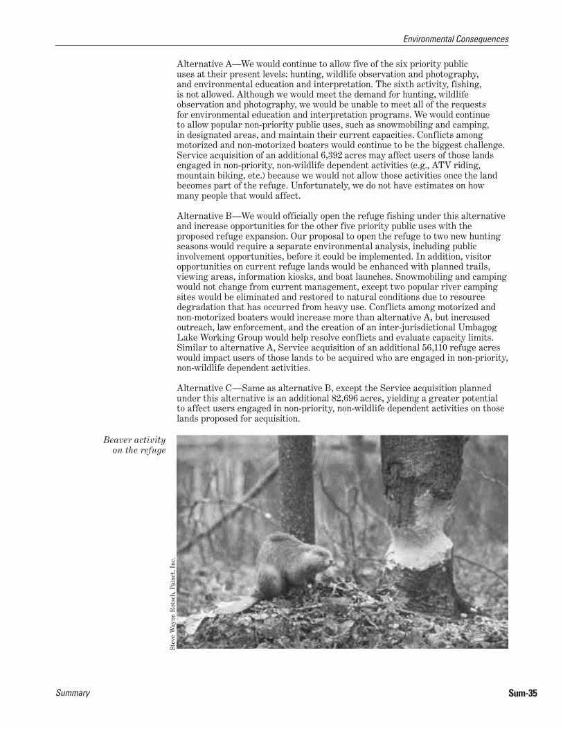
Environmental Consequences
Summary Sum-35
Alternative A—We would continue to allow five of the six priority public uses at their present levels: hunting, wildlife observation and photography, and environmental education and interpretation. The sixth activity, fishing, is not allowed. Although we would meet the demand for hunting, wildlife observation and photography, we would be unable to meet all of the requests for environmental education and interpretation programs. We would continue to allow popular non-priority public uses, such as snowmobiling and camping, in designated areas, and maintain their current capacities. Conflicts among motorized and non-motorized boaters would continue to be the biggest challenge. Service acquisition of an additional 6,392 acres may affect users of those lands engaged in non-priority, non-wildlife dependent activities (e.g., ATV riding, mountain biking, etc.) because we would not allow those activities once the land becomes part of the refuge. Unfortunately, we do not have estimates on how many people that would affect.
Alternative B—We would officially open the refuge fishing under this alternative and increase opportunities for the other five priority public uses with the proposed refuge expansion. Our proposal to open the refuge to two new hunting seasons would require a separate environmental analysis, including public involvement opportunities, before it could be implemented. In addition, visitor opportunities on current refuge lands would be enhanced with planned trails, viewing areas, information kiosks, and boat launches. Snowmobiling and camping would not change from current management, except two popular river camping sites would be eliminated and restored to natural conditions due to resource degradation that has occurred from heavy use. Conflicts among motorized and non-motorized boaters would increase more than alternative A, but increased outreach, law enforcement, and the creation of an inter-jurisdictional Umbagog Lake Working Group would help resolve conflicts and evaluate capacity limits. Similar to alternative A, Service acquisition of an additional 56,110 refuge acres would impact users of those lands to be acquired who are engaged in non-priority, non-wildlife dependent activities.
Alternative C—Same as alternative B, except the Service acquisition planned under this alternative is an additional 82,696 acres, yielding a greater potential to affect users engaged in non-priority, non-wildlife dependent activities on those lands proposed for acquisition.
Beaver activity on the refuge
Stev
e W
ayne
Rot
sch,
Pai
net,
Inc
.
Lake Umbagog National Wildlife RefugeP.O. Box 240Route 16 NorthErrol, NH 03579-0240E-Mail: [email protected]: 603/482-3415
http://lakeumbagog.fws.gov
Federal Relay Servicefor the deaf or hard of hearing1800/877 8339
U.S. Fish and Wildlife Service Websitehttp://www.fws.gov
For National Wildlife Refuge System Information:1800/344 WILD
June 2007