Embed Size (px)
Citation preview
28th Session of Asia and Pacific Commission on Agricultural Statistics
Bali, Indonesia, 10 – 14 February 2020
Use of Administrative Land
Records in India’s Agriculture
Census
Dr. Ramesh Kumar Yadav
Deputy Director
Ministry of Agriculture
India
1
APCAS/20/6.3.5
28th Session of Asia and Pacific Commission on Agricultural Statistics
Bali, Indonesia, 10 – 14 February 2020
Outline
•Agriculture Census
•Organizational Structure
•Coverage
•Schedules used for Data Collection
•Items of Data Collected
•Survey Design
•Methods of Data Collection
•Steps for Improvement of Data Quality/Control
•Processing and Dissemination of Data
2
28th Session of Asia and Pacific Commission on Agricultural Statistics
Bali, Indonesia, 10 – 14 February 2020
Agriculture Census in India
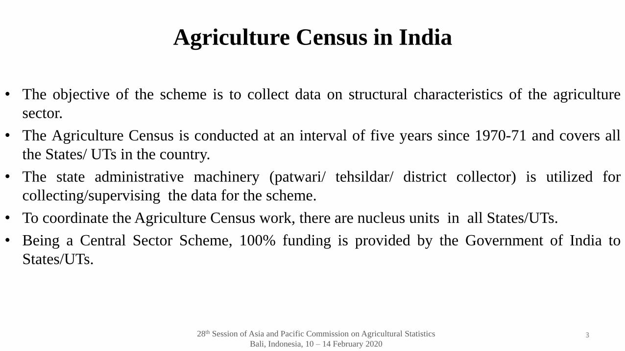
• The objective of the scheme is to collect data on structural characteristics of the agriculture
sector.
• The Agriculture Census is conducted at an interval of five years since 1970-71 and covers all
the States/ UTs in the country.
• The state administrative machinery (patwari/ tehsildar/ district collector) is utilized for
collecting/supervising the data for the scheme.
• To coordinate the Agriculture Census work, there are nucleus units in all States/UTs.
• Being a Central Sector Scheme, 100% funding is provided by the Government of India to
States/UTs.
3
28th Session of Asia and Pacific Commission on Agricultural Statistics
Bali, Indonesia, 10 – 14 February 2020
Organizational Structure
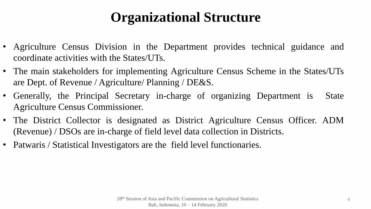
• Agriculture Census Division in the Department provides technical guidance and
coordinate activities with the States/UTs.
• The main stakeholders for implementing Agriculture Census Scheme in the States/UTs
are Dept. of Revenue / Agriculture/ Planning / DE&S.
• Generally, the Principal Secretary in-charge of organizing Department is State
Agriculture Census Commissioner.
• The District Collector is designated as District Agriculture Census Officer. ADM
(Revenue) / DSOs are in-charge of field level data collection in Districts.
• Patwaris / Statistical Investigators are the field level functionaries.
4

28th Session of Asia and Pacific Commission on Agricultural Statistics
Bali, Indonesia, 10 – 14 February 2020
Coverage
• Geographical coverage
– The Agriculture Census covers the whole country.
– Urban areas are generally excluded from the purview of Agriculture Census, ifthere is no agriculture activities are going on.
• Statistical coverage
– Phase-I: Covers all villages in Land record States (23 States) and data is re-tabulated from revenue records; sample of 20% villages (from EARAS) inNon-Land Record States(NLR) through household enquiry.
– Phase-II: sample of 20% of villages and complete enumeration in selectedvillages.
– Phase III: Sample of 7% villages and 4 holdings from each of the 5 size classesare selected. 5
28th Session of Asia and Pacific Commission on Agricultural Statistics
Bali, Indonesia, 10 – 14 February 2020
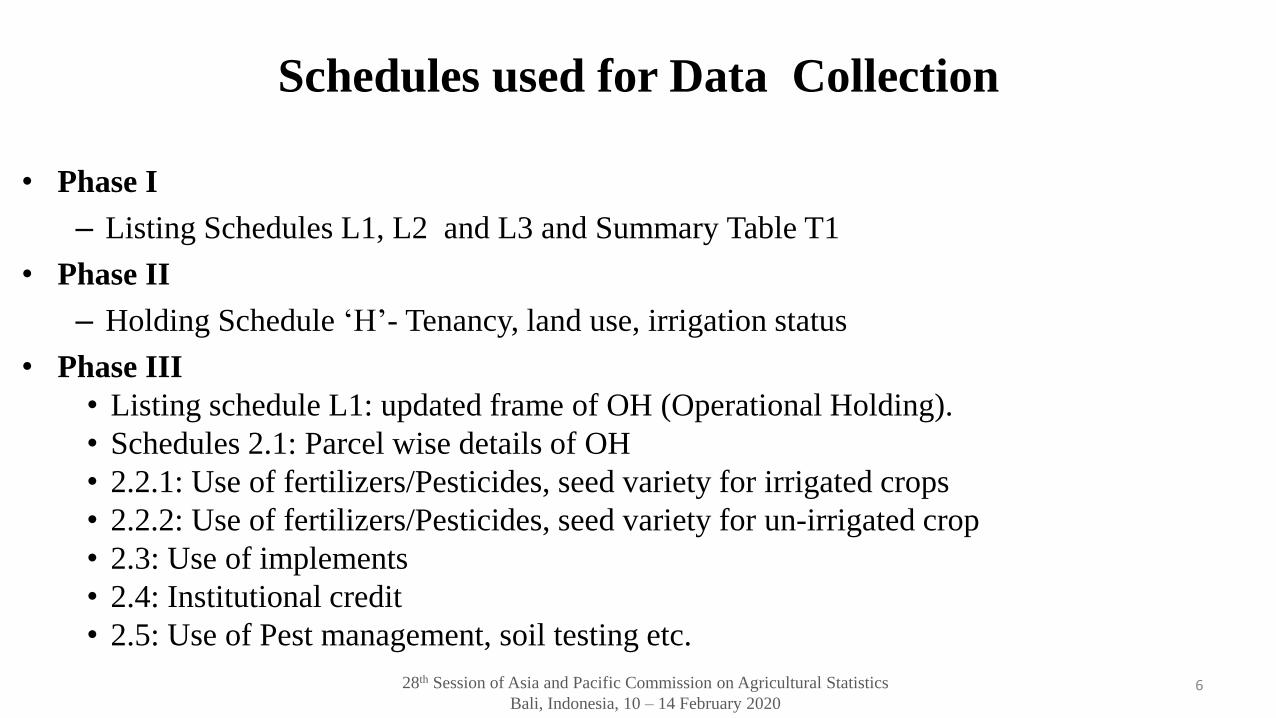
Schedules used for Data Collection
• Phase I
– Listing Schedules L1, L2 and L3 and Summary Table T1
• Phase II
– Holding Schedule ‘H’- Tenancy, land use, irrigation status
• Phase III
• Listing schedule L1: updated frame of OH (Operational Holding).
• Schedules 2.1: Parcel wise details of OH
• 2.2.1: Use of fertilizers/Pesticides, seed variety for irrigated crops
• 2.2.2: Use of fertilizers/Pesticides, seed variety for un-irrigated crop
• 2.3: Use of implements
• 2.4: Institutional credit
• 2.5: Use of Pest management, soil testing etc.
6
28th Session of Asia and Pacific Commission on Agricultural Statistics
Bali, Indonesia, 10 – 14 February 2020
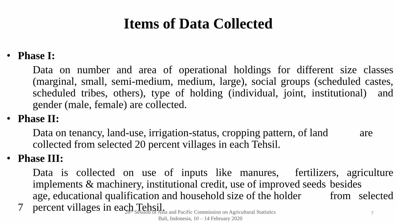
Items of Data Collected
• Phase I:
Data on number and area of operational holdings for different size classes(marginal, small, semi-medium, medium, large), social groups (scheduled castes,scheduled tribes, others), type of holding (individual, joint, institutional) andgender (male, female) are collected.
• Phase II:
Data on tenancy, land-use, irrigation-status, cropping pattern, of land arecollected from selected 20 percent villages in each Tehsil.
• Phase III:
Data is collected on use of inputs like manures, fertilizers, agricultureimplements & machinery, institutional credit, use of improved seeds besidesage, educational qualification and household size of the holder from selected
7 percent villages in each Tehsil.7
28th Session of Asia and Pacific Commission on Agricultural Statistics
Bali, Indonesia, 10 – 14 February 2020
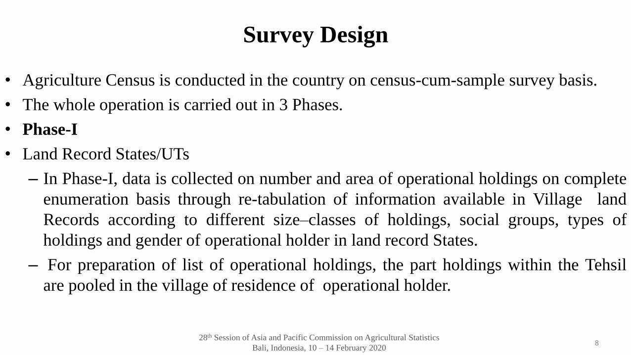
Survey Design
• Agriculture Census is conducted in the country on census-cum-sample survey basis.
• The whole operation is carried out in 3 Phases.
• Phase-I
• Land Record States/UTs
– In Phase-I, data is collected on number and area of operational holdings on complete
enumeration basis through re-tabulation of information available in Village land
Records according to different size–classes of holdings, social groups, types of
holdings and gender of operational holder in land record States.
– For preparation of list of operational holdings, the part holdings within the Tehsil
are pooled in the village of residence of operational holder.
8
28th Session of Asia and Pacific Commission on Agricultural Statistics
Bali, Indonesia, 10 – 14 February 2020
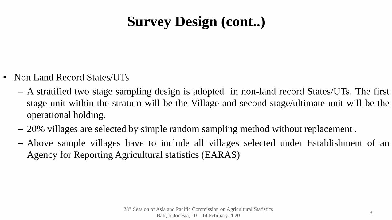
Survey Design (cont..)
• Non Land Record States/UTs
– A stratified two stage sampling design is adopted in non-land record States/UTs. The first
stage unit within the stratum will be the Village and second stage/ultimate unit will be the
operational holding.
– 20% villages are selected by simple random sampling method without replacement .
– Above sample villages have to include all villages selected under Establishment of an
Agency for Reporting Agricultural statistics (EARAS)
9
28th Session of Asia and Pacific Commission on Agricultural Statistics
Bali, Indonesia, 10 – 14 February 2020
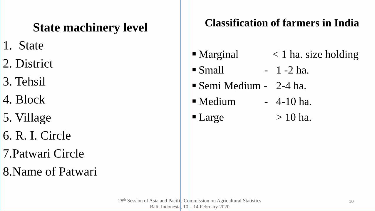
State machinery level
1. State
2. District
3. Tehsil
4. Block
5. Village
6. R. I. Circle
7.Patwari Circle
8.Name of Patwari
10
Classification of farmers in India
▪ Marginal < 1 ha. size holding
▪ Small - 1 -2 ha.
▪ Semi Medium - 2-4 ha.
▪ Medium - 4-10 ha.
▪ Large > 10 ha.
28th Session of Asia and Pacific Commission on Agricultural Statistics
Bali, Indonesia, 10 – 14 February 2020
Survey Design
• Phase-II
– Detailed data on agricultural characteristics is collected on sample basis from
randomly selected 20 percent villages both in Land Record and Non-Land
Record States.
• Land Record States/UTs
– 20% villages are selected from Timely Reporting Scheme (TRS) and Holding
Schedule-H is filled up for all the holdings in selected villages and information
on different characteristics is tabulated from the basic village land records,
viz., Khatauni and Khasra in respect of all the resident cultivators.
11
28th Session of Asia and Pacific Commission on Agricultural Statistics
Bali, Indonesia, 10 – 14 February 2020
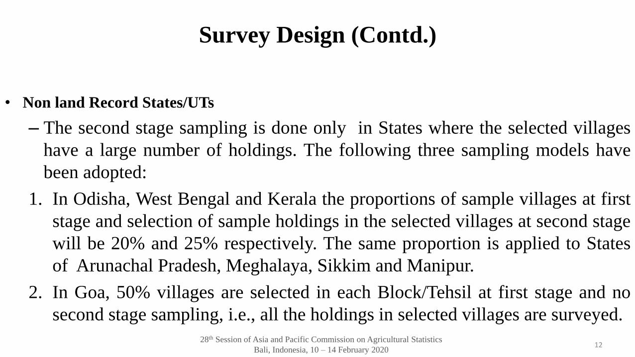
Survey Design (Contd.)
• Non land Record States/UTs
– The second stage sampling is done only in States where the selected villages
have a large number of holdings. The following three sampling models have
been adopted:
1. In Odisha, West Bengal and Kerala the proportions of sample villages at first
stage and selection of sample holdings in the selected villages at second stage
will be 20% and 25% respectively. The same proportion is applied to States
of Arunachal Pradesh, Meghalaya, Sikkim and Manipur.
2. In Goa, 50% villages are selected in each Block/Tehsil at first stage and no
second stage sampling, i.e., all the holdings in selected villages are surveyed.
12
28th Session of Asia and Pacific Commission on Agricultural Statistics
Bali, Indonesia, 10 – 14 February 2020
Survey Design (Contd.)
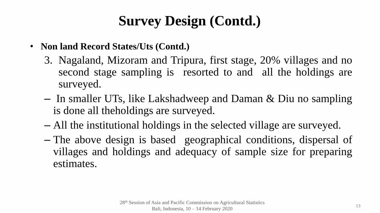
• Non land Record States/Uts (Contd.)
3. Nagaland, Mizoram and Tripura, first stage, 20% villages and nosecond stage sampling is resorted to and all the holdings aresurveyed.
– In smaller UTs, like Lakshadweep and Daman & Diu no samplingis done all theholdings are surveyed.
– All the institutional holdings in the selected village are surveyed.
– The above design is based geographical conditions, dispersal ofvillages and holdings and adequacy of sample size for preparingestimates.
13
28th Session of Asia and Pacific Commission on Agricultural Statistics
Bali, Indonesia, 10 – 14 February 2020
Survey Design (Contd.)
• In Phase-III
– Data on input use pattern are collected on a sample basis from 7 percent
selected villages and the estimates are prepared at District/State level.
– A two-stage stratified sampling is adopted for Input Survey. Tehsil/CD Blocks
are the strata and villages within the stratum form first stage unit and
operational holding are the second stage sampling unit.
– The sample size of first stage unit is 7% of the villages from each Tehsil.
– A simple random sample of 4 operational holdings is selected from each of the
5 size-groups.
– 7% villages are selected from villages of phase-II of Agriculture Census 2015-
16.14
28th Session of Asia and Pacific Commission on Agricultural Statistics
Bali, Indonesia, 10 – 14 February 2020
Methods of Data Collection
Phase-I & II : Data is collected by following two broad approaches –
–In Land Record States, broadly the information is re-tabulated by Patwaris from information
available in revenue records.
–In Non-Land Record States, the data is collected on sample basis following household
enquiry approach.
Phase-III:
–Data is collected following household enquiry approach both in land record and non-land
record States/UTs.
15
28th Session of Asia and Pacific Commission on Agricultural Statistics
Bali, Indonesia, 10 – 14 February 2020
Steps for Improvement of Data Quality/Control
• The Steering Committee consisting of various stake-holders and domain experts guides on
technical/administrative issues relating to implementation of Agriculture Census Scheme.
• The sampling scheme of the Census is designed to give a representative sample for generation
of reliable estimates.
• Comprehensive guidelines as also the manual of instructions for selection of sample,
supervision of field work, and compilation of data have been developed.
• Before commencement of the field work, training is provided to field functionaries and other
supervisory staff to clear conceptual doubts and apprise them about methods to carry out
census activities.
16
28th Session of Asia and Pacific Commission on Agricultural Statistics
Bali, Indonesia, 10 – 14 February 2020
Processing and Dissemination of Data
• On completion of the field work, data is entered and validated.
• After validating the database, trial tables are generated and are forwarded to States for
checking accuracy/consistency.
• The data is taken for inclusion in the All India Report after the approval from the State
Government.
• The results of Agriculture Census are released through a set of Reports - each for the three
phases of the Census.
• For wider dissemination of the information to general public, policy planners, researcher etc.
the results, reports and other documents of Agriculture Census and Input Survey are uploaded
on the Department’s website http://agcensus.nic.in
17
28th Session of Asia and Pacific Commission on Agricultural Statistics
Bali, Indonesia, 10 – 14 February 2020
Thank you!
Dr. Ramesh Kumar Yadav (Deputy Director)
Ministry of Agriculture, India
18