Embed Size (px)
Citation preview

Use of (H-SAF) satellite data in the
European Flood Awareness System
Peter Salamon
& EFAS Team
& EFAS Consortium

26 November 2014
European Flood Awareness System (EFAS)
• EFAS fully operational: EFAS is fully operational since September 2012 under the Copernicus Emergency Management Service.
• 4 EFAS Centers: EFAS Computational Center (ECMWF) – EFAS Dissemination Center (SMHI, RWS, SHMU) – EFAS Hydrological Data Collection Center (REDIAM, ELIMCO) – EFAS Meteorological Data Collection (JRC)
• Objectives of EFAS:
Provide complementary flood forecasting information to national services
Provide European scale overview to the ERCC
• EFAS partners: national/regional hydrometeorological authorities; currently more than 35 partners (EU & non-EU)

3
6 November 2014
COSMO
EFAS technical set up: • Distributed hydrological model
(LISFLOOD)
• Spatial extent: Europe
• Grid Resolution 5 km x 5 km
• Temporal resolution forecasts: 6 hourly with exception ECMWF EPS (daily)
• Temporal resolution IC: daily
• Sources for meteorological forecasts: German Weather Service, ECMWF, COSMO Consortium
• Forecast update at 12:00 and 00:00UTC. A total of 138 forecasts are produced daily!
DWD
ECMWF
46 November 2014
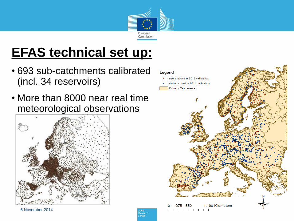
EFAS technical set up:
• 693 sub-catchments calibrated (incl. 34 reservoirs)
• More than 8000 near real time meteorological observations

Weather forecasts in EFAS
Deterministic• DWD – 7 days, ~ 7 km (Day 1 – 3), ~ 30 km (day
4 - 7), twice daily• ECMWF, 10 days, ~16 km, twice daily
Ensembles• ECMWF EPS – 10 days , ~ 30 km, 51 members,
twice daily• COSMO-LEPS - 5 days, ~ 7 km, 16 members
DWD
ECMWF

66 November 2014
EFAS web interface:
• User can zoom into his region for detailed information
• Large number of layers with additional info is available
• www.efas.eu

Comparing model and satellite rel. soil moisture in near real time
• Purpose I: added value information for the forecaster
• Purpose II: model validation in near real time
• Problem: Soil moisture ≠ soil moisture – products need to be made comparable first (parameterisation of soil layers)
• Available since May 2014
EFAS & H-SAF data:
Rel. soil moisture LISFLOOD 31 Oct. 2014
Rel. soil moisture H-SAF 31 Oct. 2014

Comparing model and satellite snow water equivalent in near real time
• Purpose I: added value information for the forecaster
• Purpose II: model validation in near real time
• Problem: accuracy of satellite SWE (tentatively 20 mm)– quality of the product is dependent on the surface characteristics
• Available since May 2014
EFAS & H-SAF data:
Snow water equivalent LISFLOOD 31 Oct. 2014
Snow water equivalent
H-SAF 31 Oct. 2014

Comparing model and satellite anomalies in near real time
• 10 day average snow water equivalent anomaly
• highly valuable information for forecasting
• Problem: different reference periods (EFAS 1990 – 2012; FMI 1979 - 2010)
EFAS & satellite data:
10 day SWE anomaly LISFLOOD 28 Apr. 2014
10 day satellite SWE anomaly FMI 28 Apr. 2014

Comparing model and satellite anomalies in near real time
• Soil moisture anomaly
• highly valuable information for forecasting
EFAS & satellite data:
Soil moisture anomaly LISFLOOD 12 May 2014
H-SAF soil moisture anomaly?
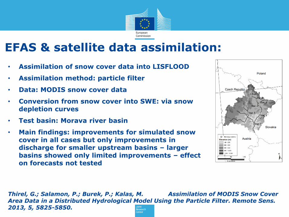
• Assimilation of snow cover data into LISFLOOD
• Assimilation method: particle filter
• Data: MODIS snow cover data
• Conversion from snow cover into SWE: via snow depletion curves
• Test basin: Morava river basin
• Main findings: improvements for simulated snow cover in all cases but only improvements in discharge for smaller upstream basins – larger basins showed only limited improvements – effect on forecasts not tested
EFAS & satellite data assimilation:
Thirel, G.; Salamon, P.; Burek, P.; Kalas, M. Assimilation of MODIS Snow Cover Area Data in a Distributed Hydrological Model Using the Particle Filter. Remote Sens. 2013, 5, 5825-5850.
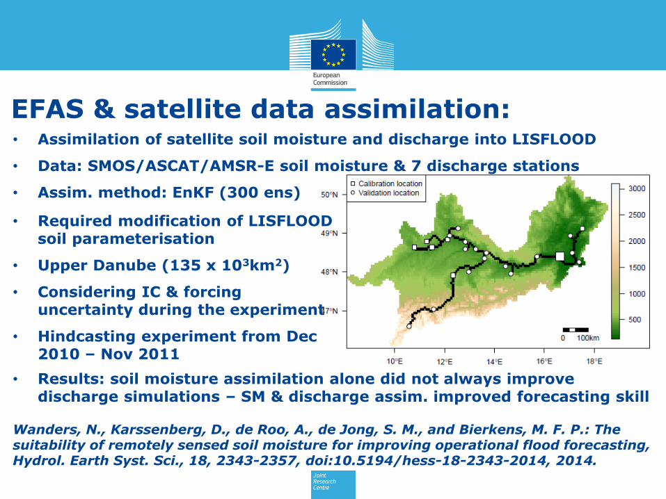
• Required modification of LISFLOOD soil parameterisation
• Upper Danube (135 x 103km2)
• Considering IC & forcing uncertainty during the experiment
• Hindcasting experiment from Dec 2010 – Nov 2011
EFAS & satellite data assimilation:
Wanders, N., Karssenberg, D., de Roo, A., de Jong, S. M., and Bierkens, M. F. P.: The suitability of remotely sensed soil moisture for improving operational flood forecasting, Hydrol. Earth Syst. Sci., 18, 2343-2357, doi:10.5194/hess-18-2343-2014, 2014.
• Assimilation of satellite soil moisture and discharge into LISFLOOD
• Data: SMOS/ASCAT/AMSR-E soil moisture & 7 discharge stations
• Assim. method: EnKF (300 ens)
• Results: soil moisture assimilation alone did not always improve discharge simulations – SM & discharge assim. improved forecasting skill

• Satellite products provide valuable complementary information in near real-time for EFAS
• H-SAF satellite anomaly products would be highly appreciated
• H-SAF accumulated precip not used because it is not operational
• Satellite soil moisture in combination with discharge data assimilation seems most promising for EFAS, HOWEVER, great challenges still are ahead:
Testing of assimilation at continental scale
Feasibility study focusing on operational aspects of data assimilation (how many ensembles in the EnKF? Design of failure mechanisms, etc….)
Conclusions & challenges:

146 November 2014
Questions?
Thank you for your attention!
For more info:
www.efas.eu