Embed Size (px)
Citation preview
Coordinated Needs Management Strategy (CNMS) Tutorial April 2015
2
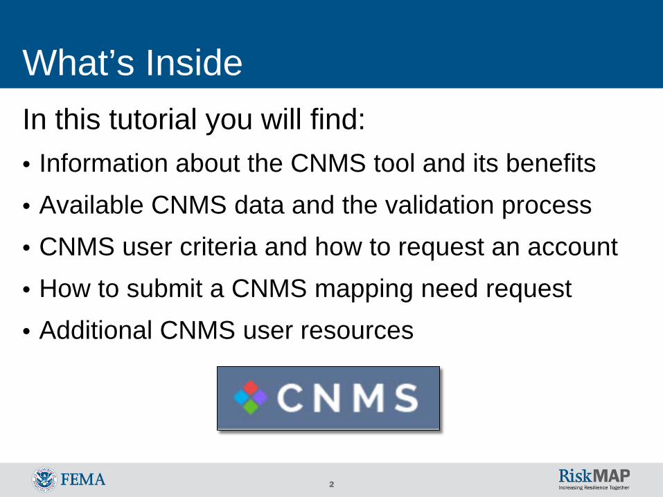
What’s Inside In this tutorial you will find: • Information about the CNMS tool and its benefits • Available CNMS data and the validation process • CNMS user criteria and how to request an account • How to submit a CNMS mapping need request • Additional CNMS user resources
3
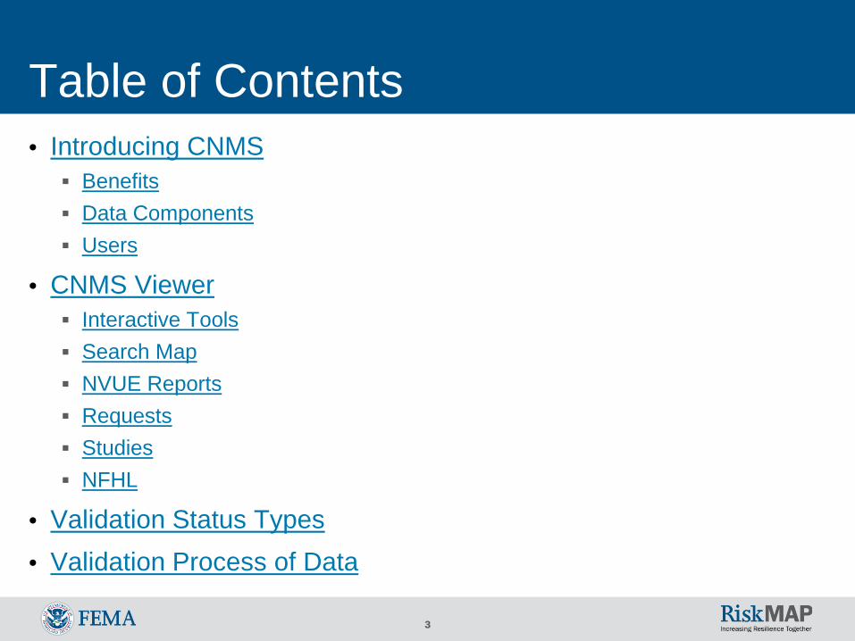
Table of Contents • Introducing CNMS Benefits Data Components Users
• CNMS Viewer Interactive Tools Search Map NVUE Reports Requests Studies NFHL
• Validation Status Types • Validation Process of Data
4
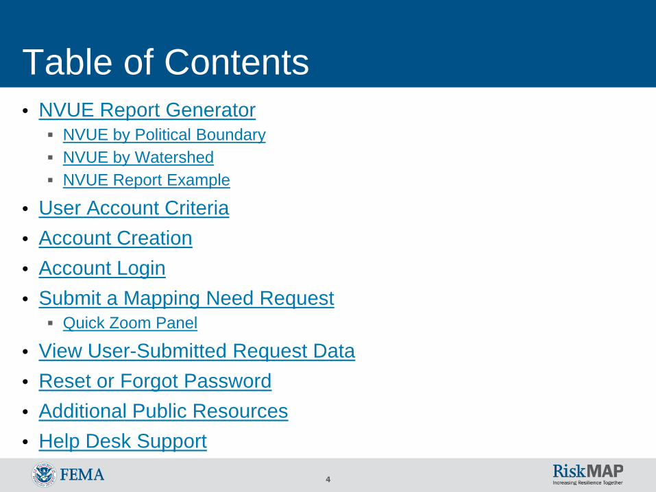
Table of Contents • NVUE Report Generator NVUE by Political Boundary NVUE by Watershed NVUE Report Example
• User Account Criteria • Account Creation • Account Login • Submit a Mapping Need Request Quick Zoom Panel
• View User-Submitted Request Data • Reset or Forgot Password • Additional Public Resources • Help Desk Support
5
Introducing CNMS • The Coordinated Needs Management Strategy (CNMS) tool
(https://msc.fema.gov/cnms/) coordinates the management of FEMA’s flood hazard mapping inventory, including validation status of flood studies and flood hazard mapping needs nationwide, with the exception of coastal study areas The CNMS tool does not reflect validation statuses of coastal shorelines or
coastal studies
• The tool identifies and tracks the lifecycle of flood studies and mapping need requests of FEMA’s flood maps (known as Flood Insurance Rate Maps or FIRMs) to determine which flood study areas are completed with up-to-date engineering methodology and which studies may warrant additional analysis
6
Introducing CNMS • FEMA uses CNMS to maintain the validity of flood hazard data and
maps and to assess if conditions on the ground are adequately represented on the FIRM Information that does not adequately represent actual conditions is considered
a mapping need and may warrant a new flood study by FEMA
7
Introducing CNMS: Benefits • CNMS helps community members and officials, and FEMA
Regions analyze and manage their flood hazard mapping inventory through the following ways: Informs mapping project planning and standardizes how new and updated
flood data is collected for flood map production Enhances data driven planning activities for map update prioritization Validates Special Flood Hazard Areas (SFHAs) and flood hazard data on
FIRMs Allows authorized account users to submit, review, track, and evaluate
mapping need requests Facilitates greater control of review and evaluation of mapping needs requests
to authorized Regional officials
8
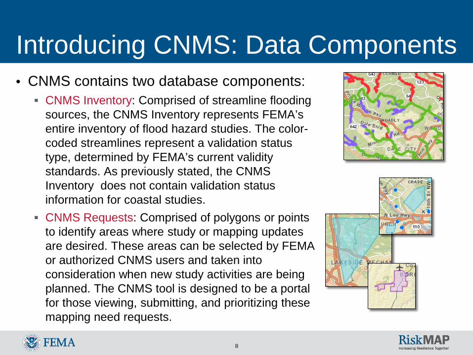
Introducing CNMS: Data Components • CNMS contains two database components: CNMS Inventory: Comprised of streamline flooding
sources, the CNMS Inventory represents FEMA’s entire inventory of flood hazard studies. The color-coded streamlines represent a validation status type, determined by FEMA’s current validity standards. As previously stated, the CNMS Inventory does not contain validation status information for coastal studies.
CNMS Requests: Comprised of polygons or points to identify areas where study or mapping updates are desired. These areas can be selected by FEMA or authorized CNMS users and taken into consideration when new study activities are being planned. The CNMS tool is designed to be a portal for those viewing, submitting, and prioritizing these mapping need requests.
9
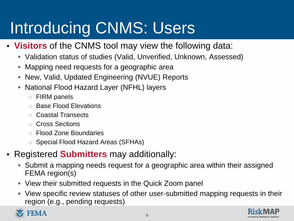
Introducing CNMS: Users • Visitors of the CNMS tool may view the following data: Validation status of studies (Valid, Unverified, Unknown, Assessed) Mapping need requests for a geographic area New, Valid, Updated Engineering (NVUE) Reports National Flood Hazard Layer (NFHL) layers
o FIRM panels o Base Flood Elevations o Coastal Transects o Cross Sections o Flood Zone Boundaries o Special Flood Hazard Areas (SFHAs)
• Registered Submitters may additionally: Submit a mapping needs request for a geographic area within their assigned
FEMA region(s) View their submitted requests in the Quick Zoom panel View specific review statuses of other user-submitted mapping requests in their
region (e.g., pending requests)
10
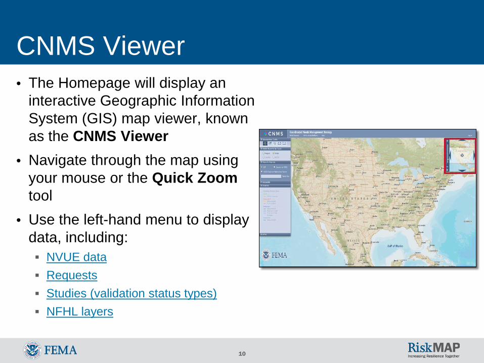
CNMS Viewer • The Homepage will display an
interactive Geographic Information System (GIS) map viewer, known as the CNMS Viewer
• Navigate through the map using your mouse or the Quick Zoom tool
• Use the left-hand menu to display data, including: NVUE data Requests Studies (validation status types) NFHL layers
11
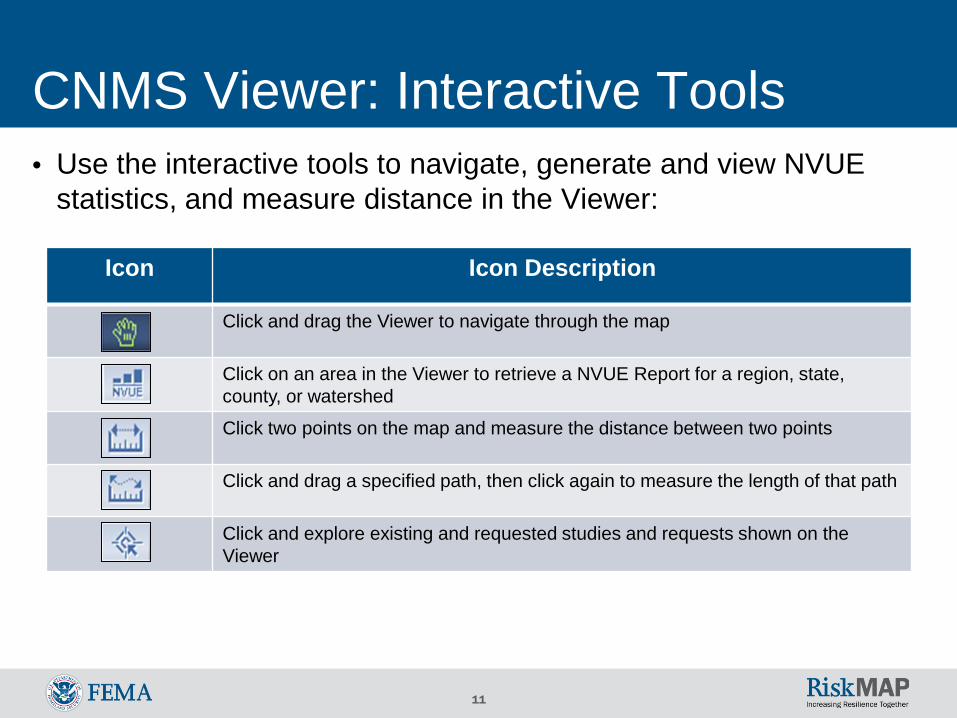
Icon Icon Description
Click and drag the Viewer to navigate through the map
Click on an area in the Viewer to retrieve a NVUE Report for a region, state, county, or watershed
Click two points on the map and measure the distance between two points
Click and drag a specified path, then click again to measure the length of that path
Click and explore existing and requested studies and requests shown on the Viewer
CNMS Viewer: Interactive Tools • Use the interactive tools to navigate, generate and view NVUE
statistics, and measure distance in the Viewer:
12
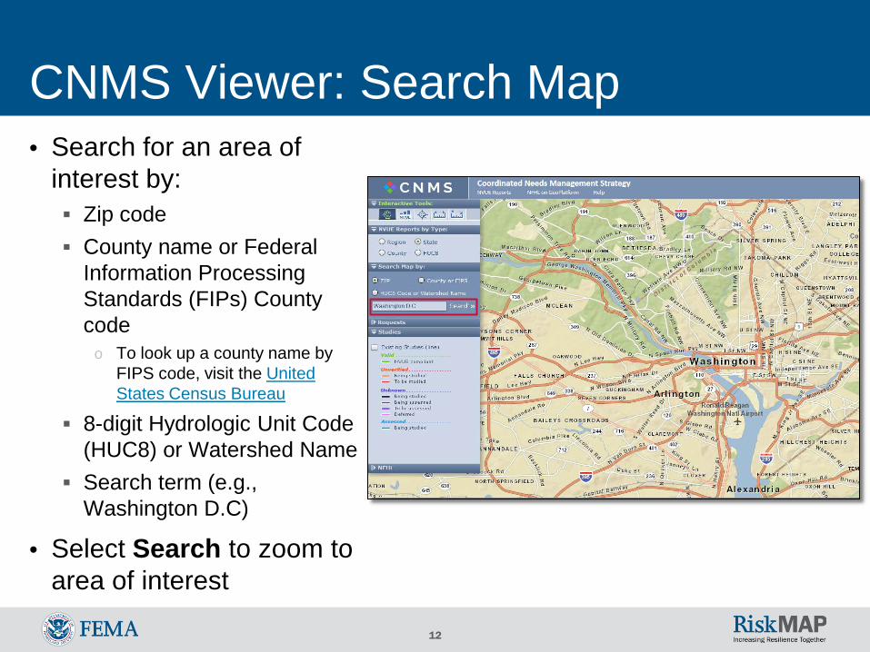
CNMS Viewer: Search Map • Search for an area of
interest by: Zip code County name or Federal
Information ProcessingStandards (FIPs) Countycode
o To look up a county name byFIPS code, visit the UnitedStates Census Bureau
8-digit Hydrologic Unit Code(HUC8) or Watershed Name
Search term (e.g.,Washington D.C)
• Select Search to zoom toarea of interest
13
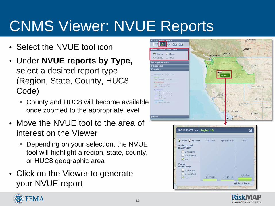
CNMS Viewer: NVUE Reports • Select the NVUE tool icon • Under NVUE reports by Type,
select a desired report type (Region, State, County, HUC8 Code) County and HUC8 will become available
once zoomed to the appropriate level
• Move the NVUE tool to the area of interest on the Viewer Depending on your selection, the NVUE
tool will highlight a region, state, county, or HUC8 geographic area
• Click on the Viewer to generate your NVUE report
14
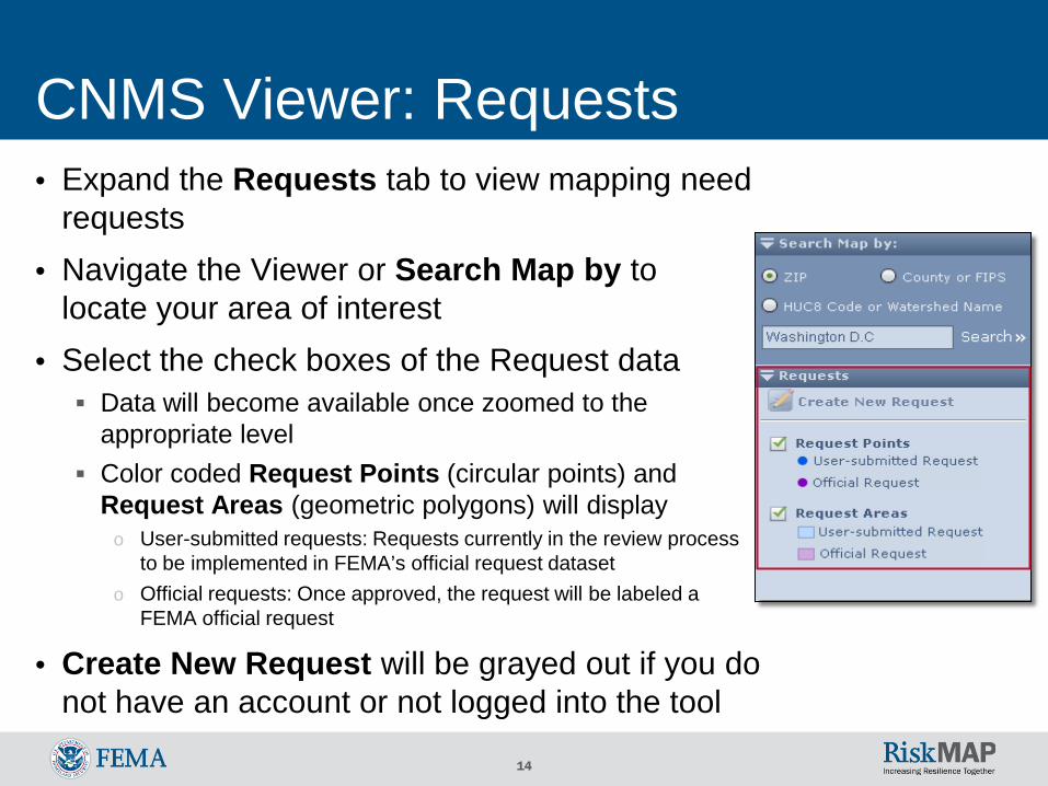
CNMS Viewer: Requests • Expand the Requests tab to view mapping need
requests • Navigate the Viewer or Search Map by to
locate your area of interest • Select the check boxes of the Request data Data will become available once zoomed to the
appropriate level Color coded Request Points (circular points) and
Request Areas (geometric polygons) will display o User-submitted requests: Requests currently in the review process
to be implemented in FEMA’s official request dataset o Official requests: Once approved, the request will be labeled a
FEMA official request
• Create New Request will be grayed out if you do not have an account or not logged into the tool
15
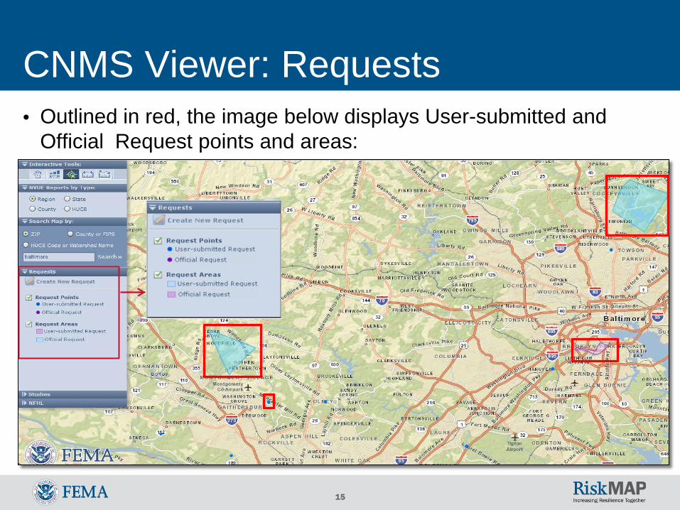
CNMS Viewer: Requests • Outlined in red, the image below displays User-submitted and
Official Request points and areas:
16
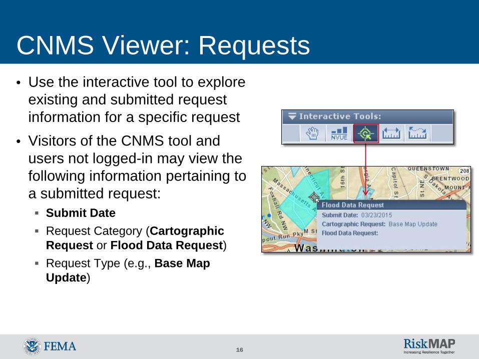
CNMS Viewer: Requests • Use the interactive tool to explore
existing and submitted request information for a specific request
• Visitors of the CNMS tool and users not logged-in may view the following information pertaining to a submitted request: Submit Date Request Category (Cartographic
Request or Flood Data Request) Request Type (e.g., Base Map
Update)
17
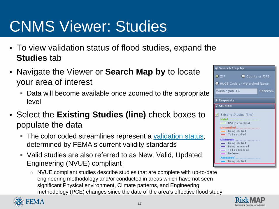
CNMS Viewer: Studies • To view validation status of flood studies, expand the
Studies tab • Navigate the Viewer or Search Map by to locate
your area of interest Data will become available once zoomed to the appropriate
level
• Select the Existing Studies (line) check boxes to populate the data The color coded streamlines represent a validation status,
determined by FEMA’s current validity standards Valid studies are also referred to as New, Valid, Updated
Engineering (NVUE) compliant o NVUE compliant studies describe studies that are complete with up-to-date
engineering methodology and/or conducted in areas which have not seen significant Physical environment, Climate patterns, and Engineering methodology (PCE) changes since the date of the area’s effective flood study
18
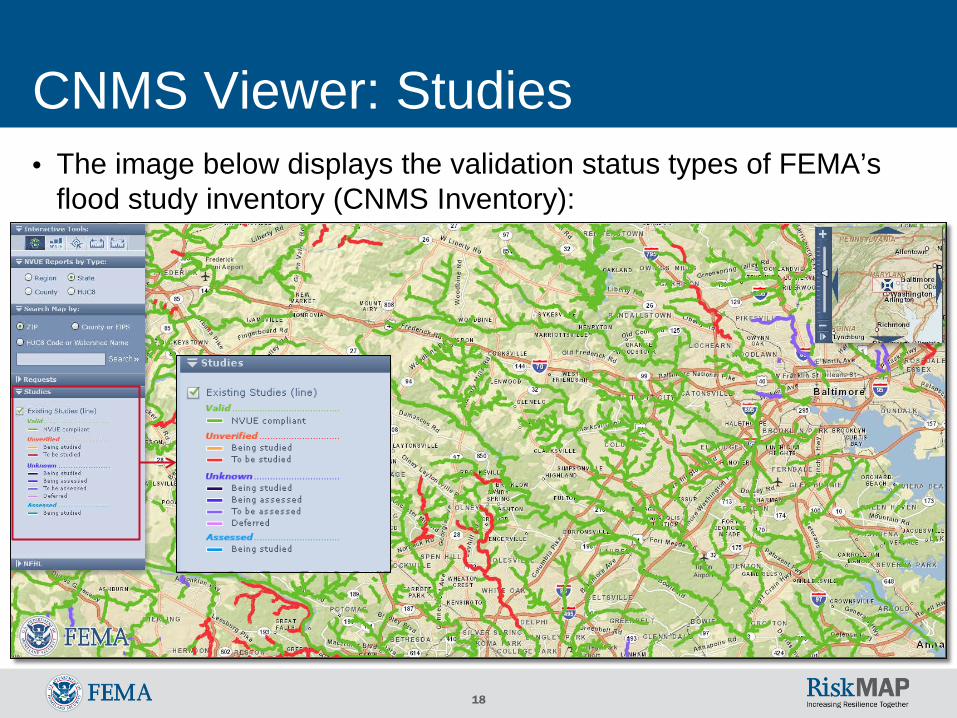
CNMS Viewer: Studies • The image below displays the validation status types of FEMA’s
flood study inventory (CNMS Inventory):
19
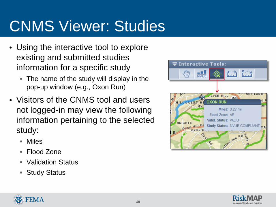
CNMS Viewer: Studies • Using the interactive tool to explore
existing and submitted studies information for a specific study The name of the study will display in the
pop-up window (e.g., Oxon Run)
• Visitors of the CNMS tool and users not logged-in may view the following information pertaining to the selected study: Miles Flood Zone Validation Status Study Status
20
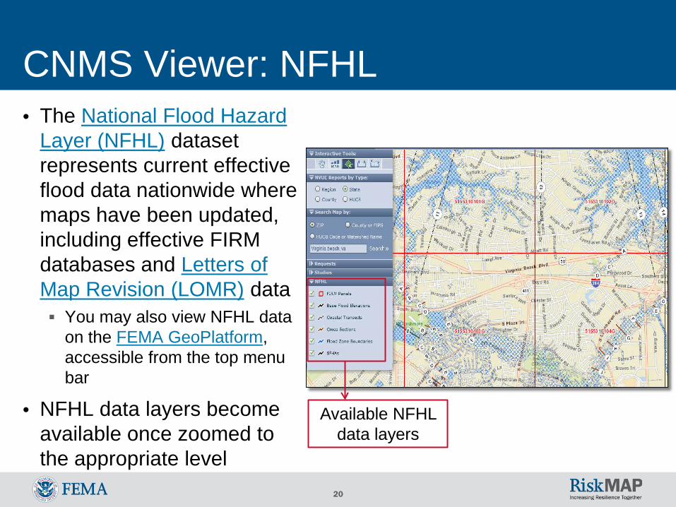
CNMS Viewer: NFHL
Available NFHL data layers
• The National Flood Hazard Layer (NFHL) dataset represents current effective flood data nationwide where maps have been updated, including effective FIRM databases and Letters of Map Revision (LOMR) data You may also view NFHL data
on the FEMA GeoPlatform, accessible from the top menu bar
• NFHL data layers become available once zoomed to the appropriate level
21
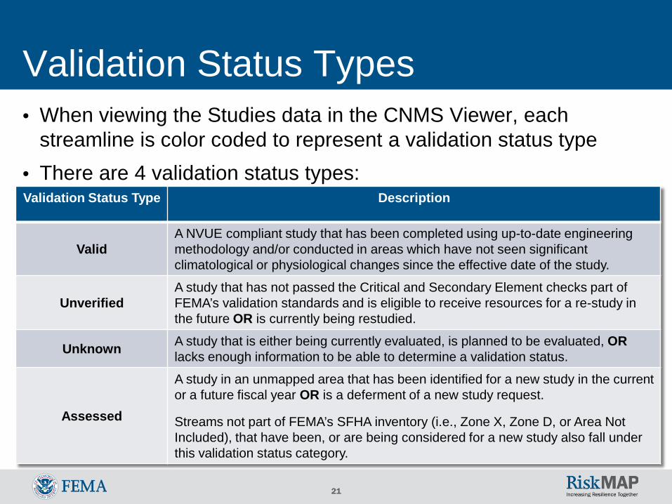
Validation Status Types
Validation Status Type Description
Valid A NVUE compliant study that has been completed using up-to-date engineering methodology and/or conducted in areas which have not seen significant climatological or physiological changes since the effective date of the study.
Unverified A study that has not passed the Critical and Secondary Element checks part of FEMA’s validation standards and is eligible to receive resources for a re-study in the future OR is currently being restudied.
Unknown A study that is either being currently evaluated, is planned to be evaluated, OR lacks enough information to be able to determine a validation status.
A study in an unmapped area that has been identified for a new study in the current or a future fiscal year OR is a deferment of a new study request.
Assessed Streams not part of FEMA’s SFHA inventory (i.e., Zone X, Zone D, or Area Not Included), that have been, or are being considered for a new study also fall under this validation status category.
• When viewing the Studies data in the CNMS Viewer, each streamline is color coded to represent a validation status type
• There are 4 validation status types:
22
Validation Process of Data • Floodplains are constantly changing due to Physical environment,
Climate patterns, and Engineering (hydraulic and hydrologic modeling) methodology (PCE) changes
• The CNMS Validation Process inspects a study against a variety of PCE changes that may have occurred since the date of the effective flood study (e.g., changes in land use, new/removed bridges and culverts, recent flood events captured by gauge data) By statute, FEMA is required to inspect all floodplain studies at least once
every 5 years
• FEMA evaluates a study on 17 elements (7 critical and 10 secondary) to determine validity For additional information on FEMA’s validation process and validity
standards, view the most current Coordinated Needs Management Strategy (CNMS) Technical Reference on FEMA’s website
23
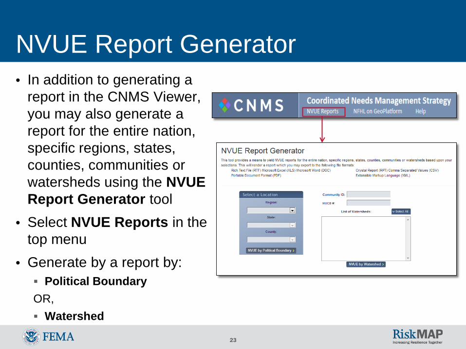
NVUE Report Generator • In addition to generating a
report in the CNMS Viewer, you may also generate a report for the entire nation, specific regions, states, counties, communities or watersheds using the NVUE Report Generator tool
• Select NVUE Reports in thetop menu
• Generate by a report by: Political Boundary OR, Watershed
24
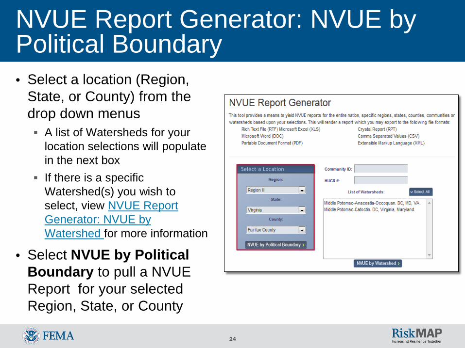
NVUE Report Generator: NVUE by Political Boundary • Select a location (Region,
State, or County) from the drop down menus A list of Watersheds for your
location selections will populate in the next box
If there is a specific Watershed(s) you wish to select, view NVUE Report Generator: NVUE by Watershed for more information
• Select NVUE by Political Boundary to pull a NVUE Report for your selected Region, State, or County
25
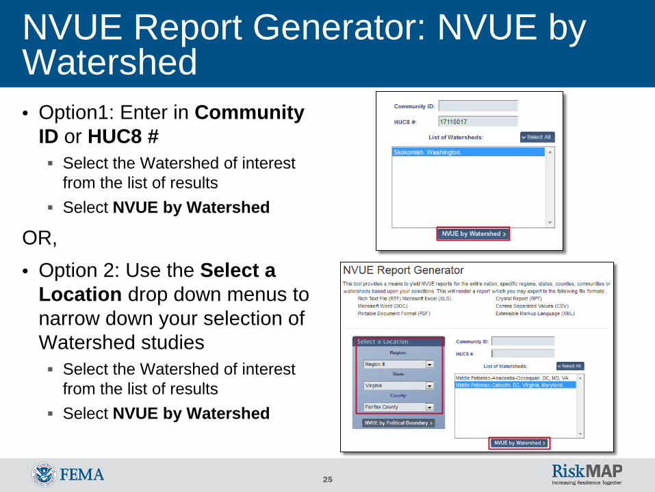
NVUE Report Generator: NVUE by Watershed • Option1: Enter in Community
ID or HUC8 # Select the Watershed of interest
from the list of results Select NVUE by Watershed
OR, • Option 2: Use the Select a
Location drop down menus to narrow down your selection of Watershed studies Select the Watershed of interest
from the list of results Select NVUE by Watershed
26
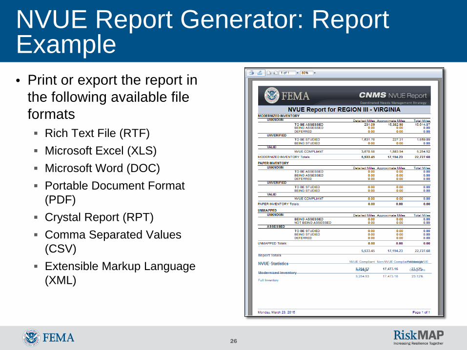
NVUE Report Generator: Report Example • Print or export the report in
the following available fileformats Rich Text File (RTF) Microsoft Excel (XLS) Microsoft Word (DOC) Portable Document Format
(PDF) Crystal Report (RPT) Comma Separated Values
(CSV) Extensible Markup Language
(XML)
27
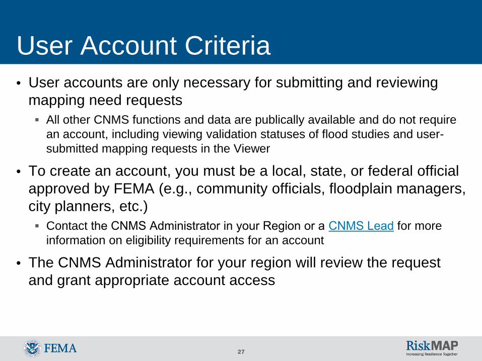
User Account Criteria • User accounts are only necessary for submitting and reviewing
mapping need requests All other CNMS functions and data are publically available and do not require
an account, including viewing validation statuses of flood studies and user-submitted mapping requests in the Viewer
• To create an account, you must be a local, state, or federal officialapproved by FEMA (e.g., community officials, floodplain managers,city planners, etc.) Contact the CNMS Administrator in your Region or a CNMS Lead for more
information on eligibility requirements for an account
• The CNMS Administrator for your region will review the requestand grant appropriate account access
28
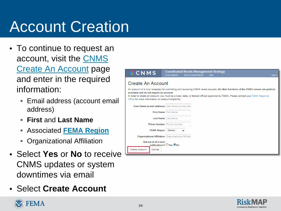
Account Creation • To continue to request an
account, visit the CNMSCreate An Account pageand enter in the requiredinformation: Email address (account email
address) First and Last Name Associated FEMA Region Organizational Affiliation
• Select Yes or No to receiveCNMS updates or systemdowntimes via email
• Select Create Account
29
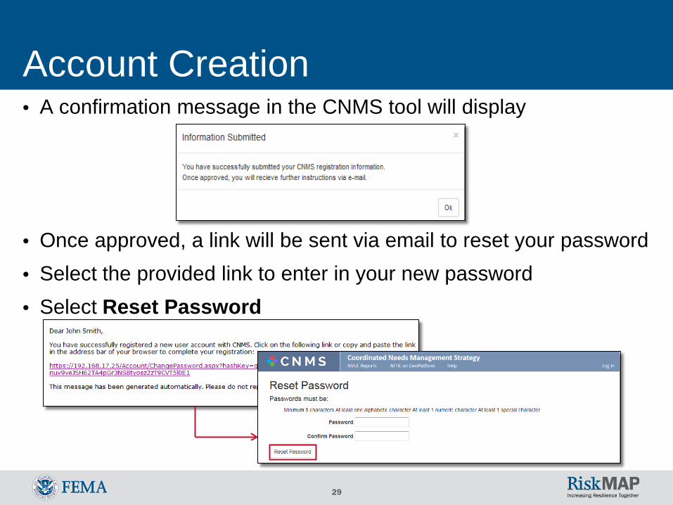
Account Creation • A confirmation message in the CNMS tool will display
• Once approved, a link will be sent via email to reset your password• Select the provided link to enter in your new password• Select Reset Password
30
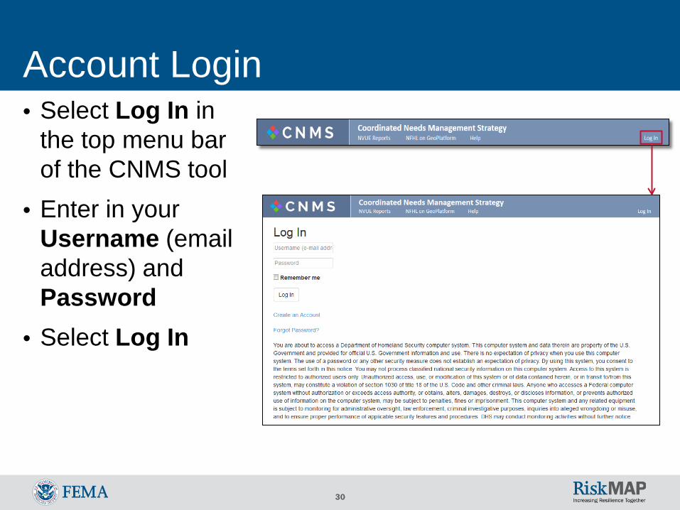
Account Login • Select Log In in
the top menu barof the CNMS tool
• Enter in yourUsername (emailaddress) andPassword
• Select Log In
31
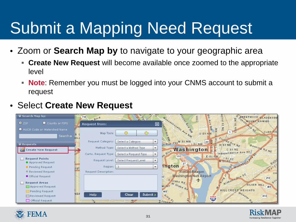
Submit a Mapping Need Request • Zoom or Search Map by to navigate to your geographic area Create New Request will become available once zoomed to the appropriate
level Note: Remember you must be logged into your CNMS account to submit a
request
• Select Create New Request
32
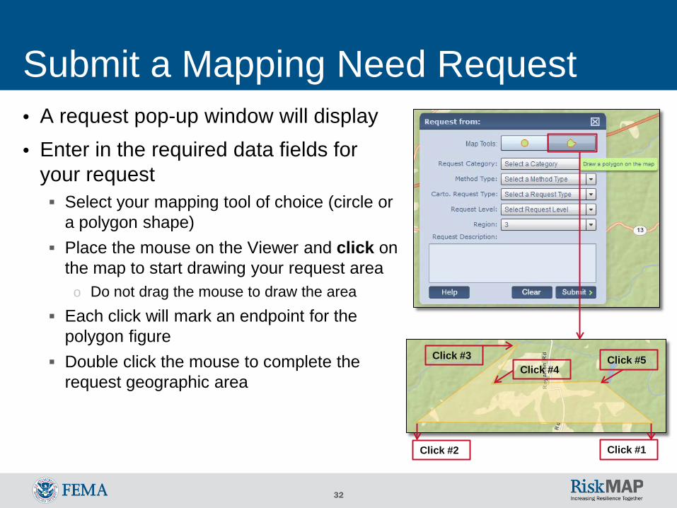
Click #1 Click #2
Click #3 Click #4
Click #5
Submit a Mapping Need Request • A request pop-up window will display• Enter in the required data fields for
your request Select your mapping tool of choice (circle or
a polygon shape) Place the mouse on the Viewer and click on
the map to start drawing your request areao Do not drag the mouse to draw the area
Each click will mark an endpoint for thepolygon figure
Double click the mouse to complete therequest geographic area
33
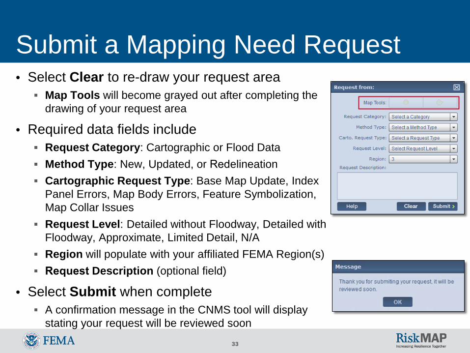
Submit a Mapping Need Request • Select Clear to re-draw your request area Map Tools will become grayed out after completing the
drawing of your request area
• Required data fields include Request Category: Cartographic or Flood Data Method Type: New, Updated, or Redelineation Cartographic Request Type: Base Map Update, Index
Panel Errors, Map Body Errors, Feature Symbolization,Map Collar Issues
Request Level: Detailed without Floodway, Detailed withFloodway, Approximate, Limited Detail, N/A
Region will populate with your affiliated FEMA Region(s) Request Description (optional field)
• Select Submit when complete A confirmation message in the CNMS tool will display
stating your request will be reviewed soon
34
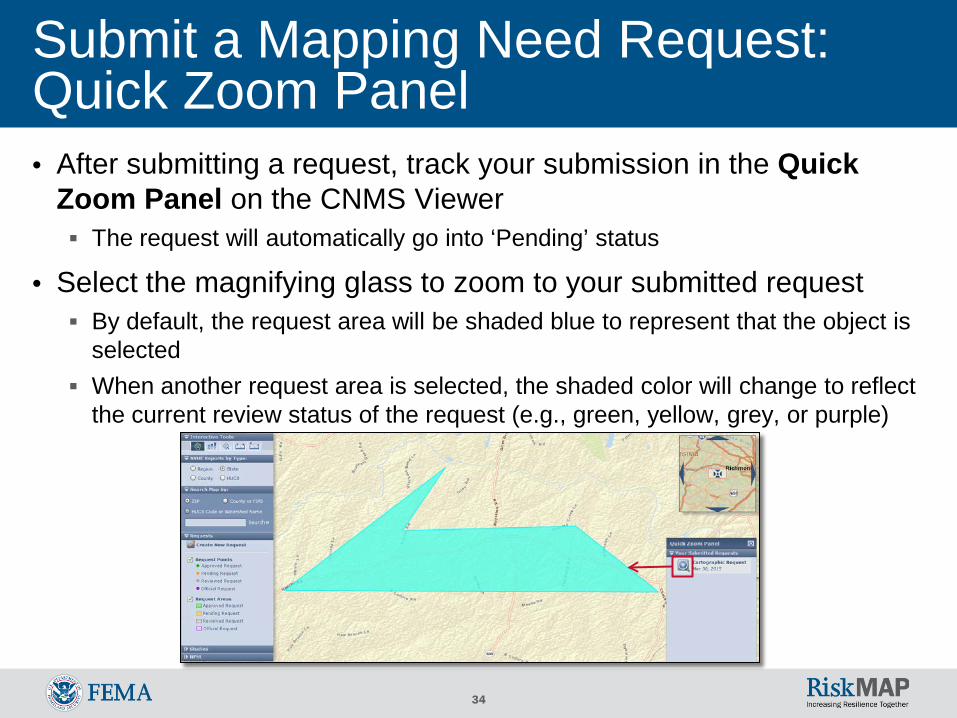
Submit a Mapping Need Request: Quick Zoom Panel • After submitting a request, track your submission in the Quick
Zoom Panel on the CNMS Viewer The request will automatically go into ‘Pending’ status
• Select the magnifying glass to zoom to your submitted request By default, the request area will be shaded blue to represent that the object is
selected When another request area is selected, the shaded color will change to reflect
the current review status of the request (e.g., green, yellow, grey, or purple)
35
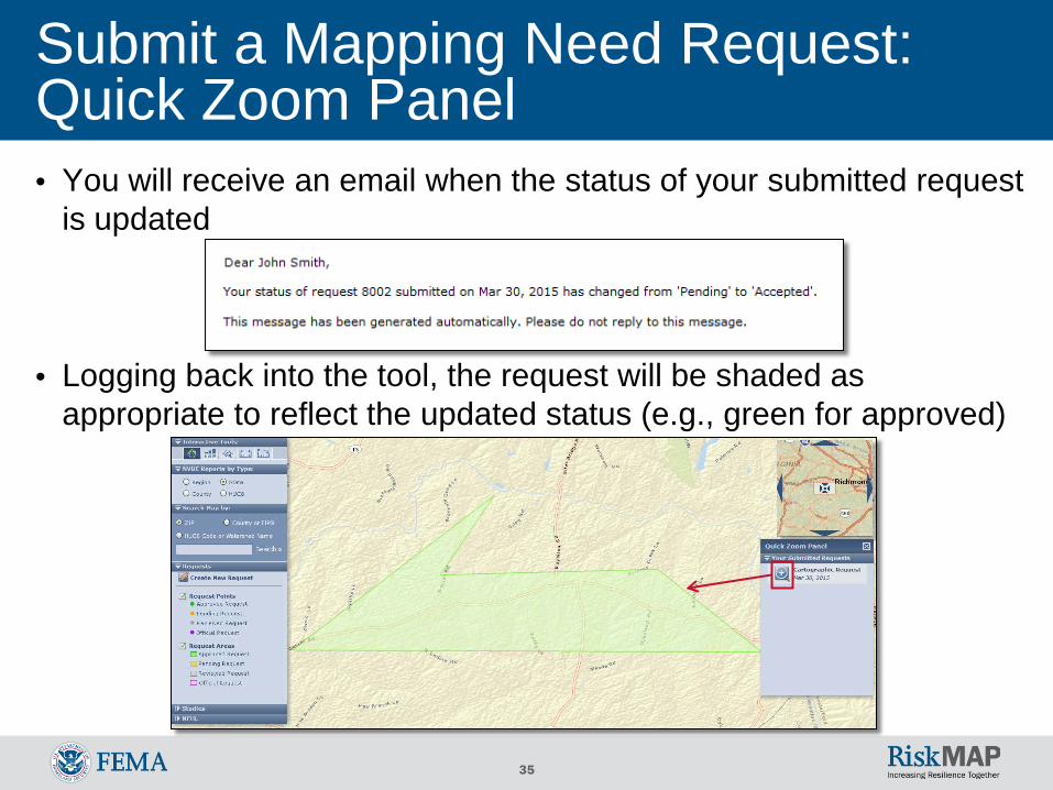
Submit a Mapping Need Request: Quick Zoom Panel • You will receive an email when the status of your submitted request
is updated
• Logging back into the tool, the request will be shaded asappropriate to reflect the updated status (e.g., green for approved)
36
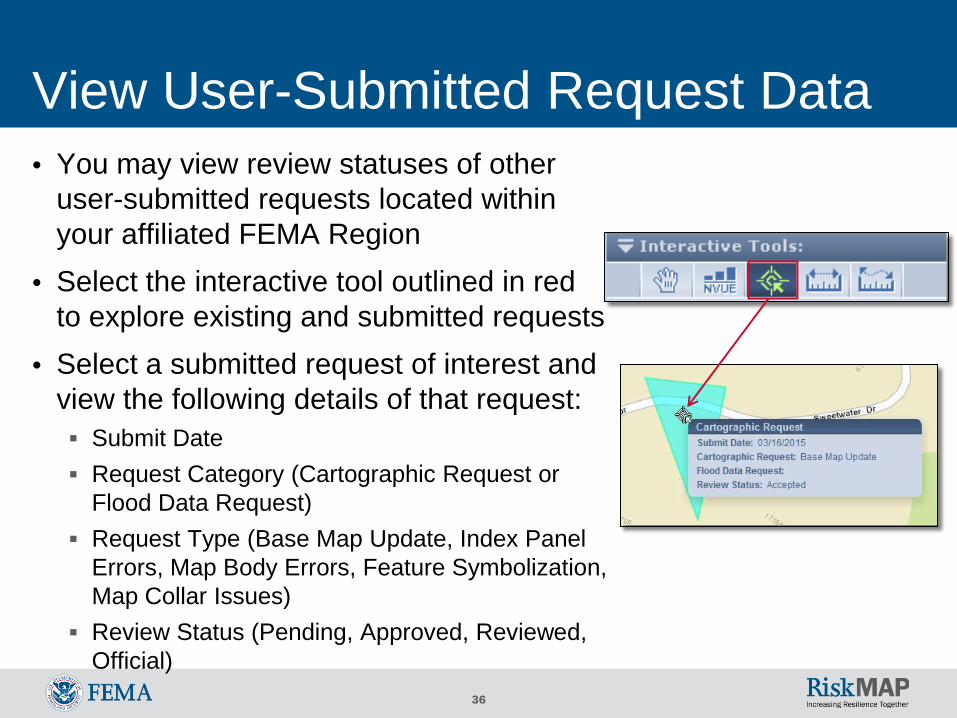
View User-Submitted Request Data • You may view review statuses of other
user-submitted requests located withinyour affiliated FEMA Region
• Select the interactive tool outlined in redto explore existing and submitted requests
• Select a submitted request of interest andview the following details of that request: Submit Date Request Category (Cartographic Request or
Flood Data Request) Request Type (Base Map Update, Index Panel
Errors, Map Body Errors, Feature Symbolization,Map Collar Issues)
Review Status (Pending, Approved, Reviewed,Official)
37
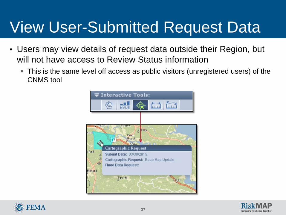
View User-Submitted Request Data • Users may view details of request data outside their Region, but
will not have access to Review Status information This is the same level off access as public visitors (unregistered users) of the
CNMS tool
38
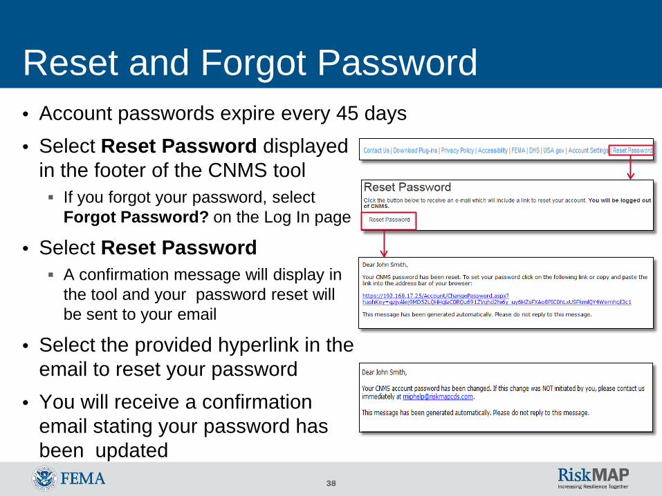
Reset and Forgot Password • Account passwords expire every 45 days• Select Reset Password displayed
in the footer of the CNMS tool If you forgot your password, select
Forgot Password? on the Log In page
• Select Reset Password A confirmation message will display in
the tool and your password reset willbe sent to your email
• Select the provided hyperlink in theemail to reset your password
• You will receive a confirmationemail stating your password hasbeen updated
39
Additional User Resources • For more information on CNMS, visit the following user resources: Webpage Fact sheet on the FEMA Library
• Or, contact the following CNMS leads: National CNMS Leads:
o Rick Sacbibit- [email protected] (Headquarters)o Andy Read- [email protected] (Headquarters)
o Jon Johnson at [email protected] (Production and Technical Services (PTS) Provider)
o Eric Danielson at [email protected] (Production and Technical Services (PTS) Provider)
Jeff Burm at [email protected] (Production and Technical Services (PTS) Provider)o
40
Help Desk Support • For Help Desk support, contact: A FEMA Map Information eXchange (FMIX) Map Specialist for flood hazard
mapping or floodplain management related inquirieso Call (1-877)FEMA MAP (1-877-336-2627) Monday-Friday, 8:00am- 6:30pm (EST)o Email [email protected] Chat with a Map Specialist Monday-Friday, 9:00am- 5:00pm (EST)
The MIP Help Desk at [email protected] for assistance in passwordresets or other system related inquiries
41