Embed Size (px)
Citation preview
Using Space Syntax to trace the Japanese urban renovation from JYOKAMACHI to modern cities What formed the city, the Centre or the Boundary?
Proceedings of the 7th International Space Syntax Symposium Edited by Daniel Koch, Lars Marcus and Jesper Steen, Stockholm: KTH, 2009.
Ref 053
053:1
Tsuyoshi Kigawa Fukui University of Technology, Department of Design, Fukui, Japan [email protected] Kyung Wook Seo Kyonggi University, Department of Architecture, Seoul, Republic of Korea [email protected] Keywords spatial configuration; spatial morphology; urban growth; urban morphology; centre; Jyokamachi Abstract Most of the spatial structures of Japanese major cities were founded as JYOKAMACHI, which means Japanese "castle town" built in pre-modern era. In contrast to castle towns in Europe and other Asian countries, the characteristics of JYOKAMACHI can be summarized in the nonexistence of city walls, and the distinct zoning based on the social level; SAMURAI (Warrior), merchants and the clergy class. Since the Meiji period (1868-1912), JYOKAMACHI had been remodelled under the strong influence of modernization, in an attempt to catch up with the western countries. Social renovation could be understood as the transformation in meaning of the castle, from centre of authority to a mere symbolic centre. And, the transition changed the spatial layouts in Japanese cities. The Meiji Restoration witnessed the discontinuation of the Federal Lord's prerogative and freedom with regard to the choice of residence, and they had leaded an exclusion of conventional boundaries. This paper aims to analyze the process how the castle cities had been reformed by means of Space Syntax. For the purpose, we investigated the process of urban modernization in several cities; Kyoto, Hikone, Fukui, and Otsu, which were founded as Jyokamachi. Firstly, we analyzed the forms in pre-modern era from historical map. And, we compared the zoning and the spatial configuration. Then, we examined the modernization process on the cities. By studying the JYOKAMACHI and the process of modernization, we could understand the starting point and the growth in the cities from past to today. •From the comparison between the spatial configuration and historical document, we found the difference among the cities. In the cases of HIKONE and FUKUI, in pre-modern, it had a tendency, which they had low permeability and, the KYOTO and Otsu had higher permeability. The reason could be presumed that former cities were based on 'Defensive castle town' and the latter were 'Commercial castle town'. Then, in the modernization process, the former two cities had difficulty to be reborn in modern cities, but the other two were smoothly transformed.
1. Introduction For an urban researcher who uses space syntax, the problem often encountered is where to set up the boundary of the city for axial analysis. While this problem may be easily solved for researchers who study medieval European cities, it is a much more difficult question for space syntax researchers studying Asian cities. Asian cities have obscure boundaries, and they rapidly expand. In one of Asia's cultural spheres, Japan, the definitions of boundary and centre are related to the culture and are much more than physical aspects. For example, in Japan, there is no law established for the precise location of the country's capital, because the capital is where the emperor lives. In the same way, the feature of a local town in Japan could be characterized and categorized by where the symbolic centre of the town locates. Monzenmachi (a temple or Shrine town) was formed around a
Proceedings of the 7th International Space Syntax Symposium Edited by Daniel Koch, Lars Marcus and Jesper Steen, Stockholm: KTH, 2009. 053:2
temple or Shrine, and JYOKAMACHI, which is studied in this paper, was formed around a castle, the place where the feudal lord lived. The territory of a feudal lord was traditionally measured as the amount of rice the land was calculated to yield. The land, including rice fields, was not surrounded by the castle wall. This differs from other Far Eastern cities such as Korea or China. In Japan, the decline of the central area of cities is an urban problem requiring an immediate solution. Although it is seldom pointed out, one of the reasons for the problem could be that most of the inhabitants consider the ritual centre to be the city centre, not the physical and traffic centres of today, which can be distilled by mathematical or morphological analysis. In other words, the boundaries of the city expand; however, they do not take into account the expansion and the transformation. With regard to this point, the analysis by using space syntax could be a powerful methodology to show how the present condition differs from the historical layout. Most of the principal Japanese cities decided their basic layouts in pre-modern times, expanded in response to the inflow of settlers and transformed into rational forms for the automobile age. Thus, the reason for the urban problems in Japanese cities today is the expansion and transformation of these cities that led them in the wrong direction, or even if the direction was correct, the transformation was not sufficient. Following this hypothesis, we need to analyze (1) what was the foundation of the city built in pre-modern time and (2) how modern planning leads the city. The discussion in this paper could be summarized in one question, 'What formed the city, the Centre or the Boundary?' For this argument, we analyzed several JYOKAMACHI (castle towns), Kyoto, Hikone, Fukui and Otsu in this paper.
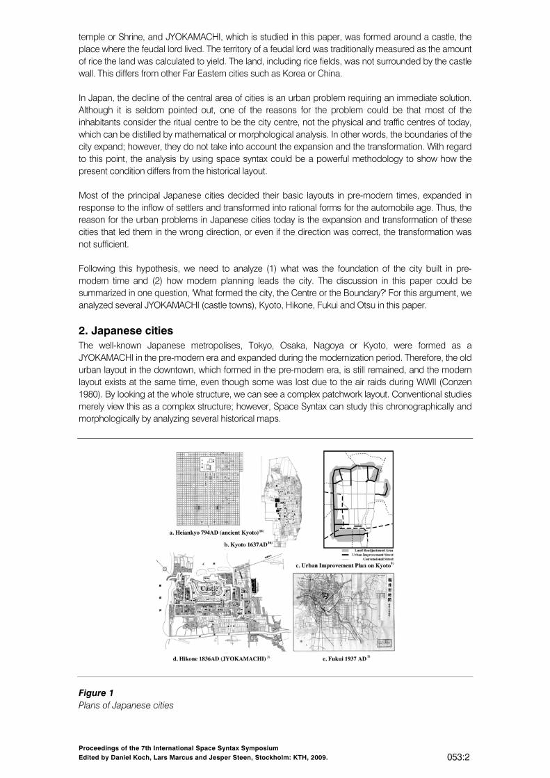
2. Japanese cities The well-known Japanese metropolises, Tokyo, Osaka, Nagoya or Kyoto, were formed as a JYOKAMACHI in the pre-modern era and expanded during the modernization period. Therefore, the old urban layout in the downtown, which formed in the pre-modern era, is still remained, and the modern layout exists at the same time, even though some was lost due to the air raids during WWII (Conzen 1980). By looking at the whole structure, we can see a complex patchwork layout. Conventional studies merely view this as a complex structure; however, Space Syntax can study this chronographically and morphologically by analyzing several historical maps.
Figure 1 Plans of Japanese cities
Proceedings of the 7th International Space Syntax Symposium Edited by Daniel Koch, Lars Marcus and Jesper Steen, Stockholm: KTH, 2009. 053:3
2.1. JYOKAMACHI Let us consider first the JYOKAMACHI, which was the foundation of the present cities. We roughly categorized JYOKAMACHI in two types: commercial castle towns and defensive castle towns. For example, Kyoto was the place where the Emperor lived. Therefore, we can say the capital of Japan was Kyoto, and thus, not warriors but merchants were important in this town. Furthermore, the layout of Kyoto was an orthogonal grid although it was not suitable for defending the town. We call this type as a commercial castle town. Contrary to the commercial castle town, the defensive castle town aimed at the defence by the complex streets. Therefore, even today, we can see dogleg streets in a defensive castle town. Hence, the castle, which should be defended, is located in a segregated place in terms of space syntax. The wall that surrounded the entire city did not exist, and the city was connected to the farm villages in a comparatively gentle fashion. In addition to the castle, which became a ceremonial centre, a commercial area existed downtown. By comparing these two types, this paper will discuss whether the centre sets the boundary or the boundary leads to the centre. 2.2. Modernization The castle town formed as a base of the city greatly changed with the modern wave. The JYOKAMACHI, the foundation of the present cities, changed dramatically during modernization. Two causes led to the change: (1) migration from rural areas and (2) enforcement of city planning laws. The Meiji Restoration witnessed the discontinuation of the Federal Lord's prerogative and freedom with regard to the choice of residence, and this led to an exclusion of conventional boundaries. Urban migration was triggered by the collapse of the feudalistic system, then the farmers could live anywhere and the SAMURAI lost their territory and needed to move to the metropolis. At the beginning of the modernization period, the Japanese government could do only minor correspondence; however, the enforcement of city planning laws in 1919 and the recovery after the Great Kanto earthquake in 1923 could be one of the cues that led to expansion, and many of the cities were expanded. For expansion, the urban improvement plans were implemented as a methodology (Sorensen 2002).
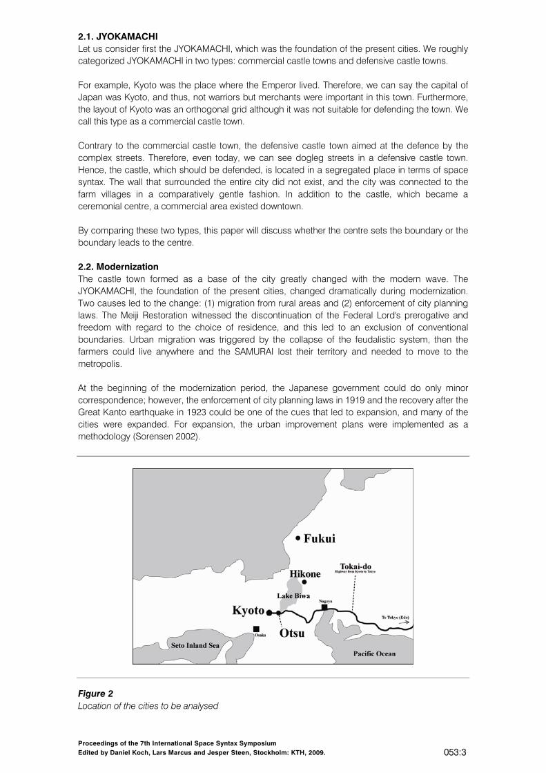
Figure 2 Location of the cities to be analysed
Proceedings of the 7th International Space Syntax Symposium Edited by Daniel Koch, Lars Marcus and Jesper Steen, Stockholm: KTH, 2009. 053:4
Fig.1.c. is a map showing the urban improvement plan in Kyoto. As we can see from several map characteristics, the plan does not change the entire structure but installed several important lines. In the case of Kyoto, the planners preserved the historical area and left it untouched. Therefore, the newly designed streets were located in the outer area of Kyoto. In another town, we can notice interesting urban renovation cases that the plans just traced the farm roads. For example, in Fig.1.e., we can see the strong grid layout of the map. This road was originally a farm road in a rice field, while presently, these areas are residential areas.
3. Methodology In this paper, we used the Urban Entropy Coefficient (UEC) as an index to study JYOKAMACHI in addition to space syntax conventional indexes. 3.1. Urban Entropy Coefficient The UEC is an index showing the degree of estrangement that can be seen between the distributions of Global and Local (Kigawa and Furuyama 2004). Equation (2) defines the UEC. Since each axial line (AL) has its own Global and Local values, we can describe a spatial system as AL1 (x1, y1), AL2 (x2, y2),...ALn (xn, yn), where xn represents the Global value and yn the Local value of ALn. A high UEC value implies that the estrangement between the Global and Local systems is relatively high. We can thus infer that the city does not have a good balance between the Global and Local, and it has a confusing layout (cf Hillier 1996, Stegen1999).
Furthermore, as it was pointed out in a paper in SSS5 (Kigawa and Furuyama 2005), the numerical value of Global and Local (Radius = 3 in Axman) corresponds in a pure grid. The pure grid is a grid without any void, and correspondence is UEC = 0. Then, from the UEC value, we can understand how much the layout differs from the pure grid.
4. Case studies 4.1. Kyoto Kyoto was the Japanese capital from 794 AD to 1868 AD. It was constructed in the shape of an orthogonal grid in the beginning of 794 AD (see fig.1.a.). Until pre-modern times, Kyoto had been burned down several times; and, Kyoto's original shape had disappeared. The foundation of the town of today was laid in the pre-modern era. Hideyoshi, a very powerful man at the time, divided the orthogonal square into two rectangles, shifted the temples to the edge of the town and constructed a castle wall around the whole of Kyoto. Thanks to a lack of extensive war devastation, the urban area of present-day central Kyoto developed during the Edo period (1603-1867). As a result of the Meiji restoration, the political system underwent a dramatic change towards the end of the Edo period, and in 1868, the capital was shifted to Tokyo. An internal war that broke out before the restoration had damaged Kyoto and aristocrats followed the emperor and fled to the new capital. These events led to the decline of Kyoto. In the Meiji period (1868-1912), the new
Proceedings of the 7th International Space Syntax Symposium Edited by Daniel Koch, Lars Marcus and Jesper Steen, Stockholm: KTH, 2009. 053:5
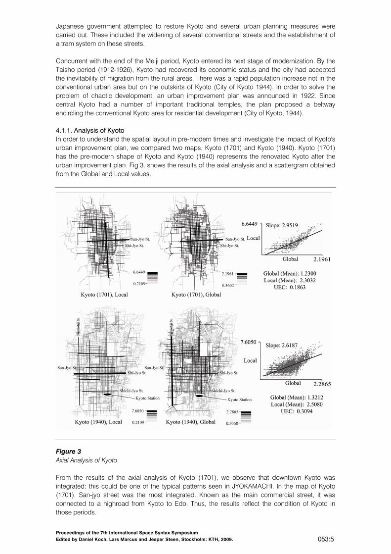
Japanese government attempted to restore Kyoto and several urban planning measures were carried out. These included the widening of several conventional streets and the establishment of a tram system on these streets. Concurrent with the end of the Meiji period, Kyoto entered its next stage of modernization. By the Taisho period (1912-1926), Kyoto had recovered its economic status and the city had accepted the inevitability of migration from the rural areas. There was a rapid population increase not in the conventional urban area but on the outskirts of Kyoto (City of Kyoto 1944). In order to solve the problem of chaotic development, an urban improvement plan was announced in 1922. Since central Kyoto had a number of important traditional temples, the plan proposed a beltway encircling the conventional Kyoto area for residential development (City of Kyoto, 1944). 4.1.1. Analysis of Kyoto In order to understand the spatial layout in pre-modern times and investigate the impact of Kyoto's urban improvement plan, we compared two maps, Kyoto (1701) and Kyoto (1940). Kyoto (1701) has the pre-modern shape of Kyoto and Kyoto (1940) represents the renovated Kyoto after the urban improvement plan. Fig.3. shows the results of the axial analysis and a scattergram obtained from the Global and Local values.
Figure 3 Axial Analysis of Kyoto From the results of the axial analysis of Kyoto (1701), we observe that downtown Kyoto was integrated; this could be one of the typical patterns seen in JYOKAMACHI. In the map of Kyoto (1701), San-jyo street was the most integrated. Known as the main commercial street, it was connected to a highroad from Kyoto to Edo. Thus, the results reflect the condition of Kyoto in those periods.
Proceedings of the 7th International Space Syntax Symposium Edited by Daniel Koch, Lars Marcus and Jesper Steen, Stockholm: KTH, 2009. 053:6
From the analysis of Kyoto (1940), we observe that the urban improvement plan had a strong impact on the whole structure of Kyoto. First, both Global and Local values increased, and the most integrated east-west bounds changed from San-jyo st. to Shi-jyo st. Further, we were able to understand the planner's intentions underlying the integration of Shichi-jyo street, the street nearest to Kyoto station, in the construction of a new entrance into Kyoto. Global indicates that several north-south streets from Kyoto station have been integrated; Shichi-jyo street itself is integrated in Local. 4.1.2. An interpretation of the results of Kyoto's evolution process In 1701, Kyoto may have had one of the typical pre-modern city shapes, constructed by meeting the balance between demands for quality and quantity during the long period of peace, when the condition in society was static. Owing to the difficulty in developing the central area, the plan included the construction of a beltway. Thus, in 1940, Nishiohji Street became the main axis of Kyoto. Subsequently, the balance that had been achieved during the pre-modern era was disrupted. As seen from the changes in the Urban Entropy Coefficient (UEC), Kyoto (1701): UEC 0.1863 and Kyoto (1940): UEC 0.3094, Kyoto changed from a static to a dynamic city. The dynamic condition could be one of reasons behind Kyoto's expansion after WWII. An analysis of Kyoto (1996) is presented in the proceedings of the fifth Space Syntax Symposium (Kigawa and Furuyama, 2005). From the analyses, we understand the impact of the installation of new streets in a city constructed by a strong grid. As seen in the pure grid, the expansion of structures in the grid city could enhance traffic-efficiency. Thus, the integration of Kyoto was beneficial. 4.2. Hikone Hikone is one of the most typical JYOKAMACHI. It was segregated purely by social classes into higher SAMURAI, lower SAMURAI and merchant class (City of Hikone 1960). The feudal lord of Hikone belonged to an honourable family and was close to the SHOGUN. His fief was huge and its castle, splendid; it has been nominated as a national treasure in Japan. Hikone was a very important fief in the pre-modern era, and therefore, its fall after modernization was rapid. Hikone was far from a metropolis and yet, there were too many higher SAMURAI to maintain. They lost their solid status and had to move to another city, namely, Tokyo. Before discussing social change, we will focus on the urban layout in pre-modern times. Hikone was formed as a series of concentric circles with a castle at the centre. The castle was surrounded by three moats, which divided the zones. Higher SAMURAI stayed between the first moat (enclosing the castle) and the second moat (City of Hikone 1962). The zone between the second and third moats was preserved for the middle class SAMURAI and merchants, and this place was called downtown. Downtown was initially close to the castle; however, year-by-year, the centre of the town shifted more to the east, where it connects to the highway. After modernization, the higher SAMURAI sold their land and moved to other cities. Schools and factories soon replaced the mansions. Several parts of Hikone were renovated; however, complete urban renovation only took place in 1935. An urban improvement plan was proposed in order to enhance traffic efficiency and yet reserve the historical layout, resulting in strong streets being built on the moats (City of Hikone 1964). Therefore, nevertheless the improvement, even today, Hikone is known as the town with a labyrinth-like layout. 4.2.1. Axial analysis of Hikone To understand the urban layout of Hikone in pre-modern times, we analysed a historical 1836 map. We observed that downtown Hikone was integrated in the same manner as Kyoto. DENBACHO was the place of KOSATSUJYO, which means a place of message board from administration. The Global centre was located on the DENBACHO. The axial analysis depicted the condition of Hikone in 1836. Until 1920, the street layout, which was suitable for defence, was constructed rationally. This could be seen from the decrease in the number of axial lines from 640 to 386. Then the mean of Global
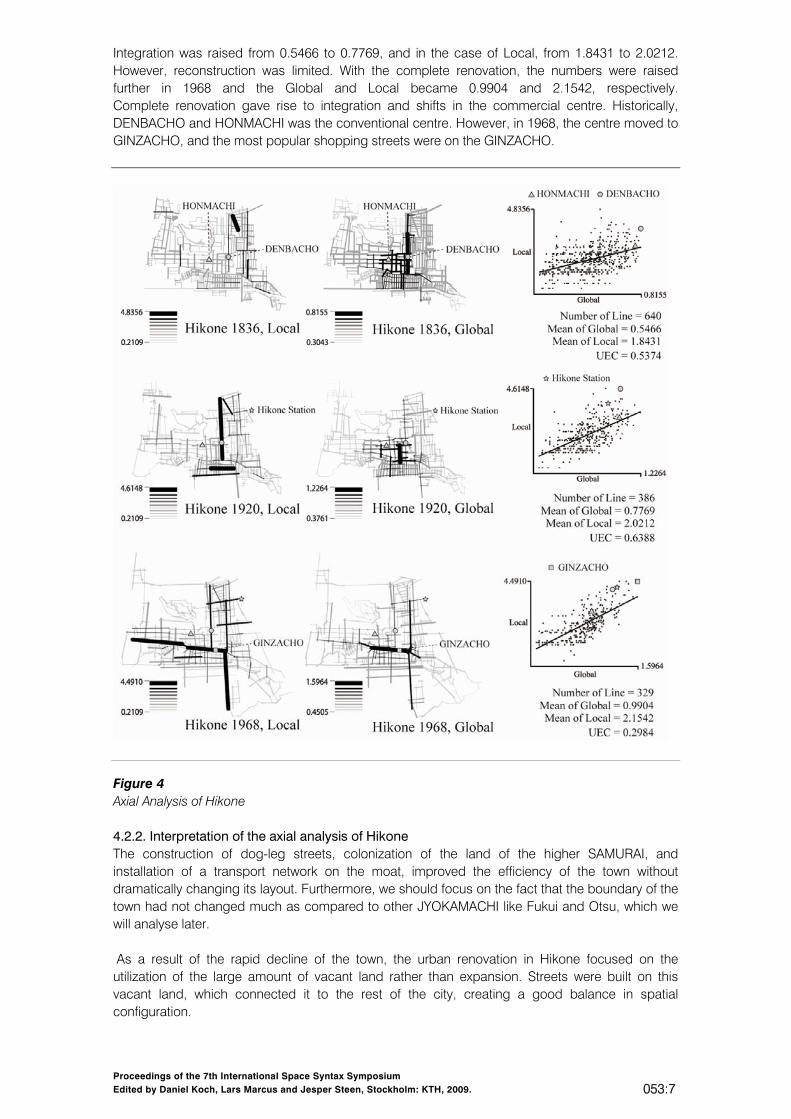
Proceedings of the 7th International Space Syntax Symposium Edited by Daniel Koch, Lars Marcus and Jesper Steen, Stockholm: KTH, 2009. 053:7
Integration was raised from 0.5466 to 0.7769, and in the case of Local, from 1.8431 to 2.0212. However, reconstruction was limited. With the complete renovation, the numbers were raised further in 1968 and the Global and Local became 0.9904 and 2.1542, respectively. Complete renovation gave rise to integration and shifts in the commercial centre. Historically, DENBACHO and HONMACHI was the conventional centre. However, in 1968, the centre moved to GINZACHO, and the most popular shopping streets were on the GINZACHO.
Figure 4 Axial Analysis of Hikone 4.2.2. Interpretation of the axial analysis of Hikone The construction of dog-leg streets, colonization of the land of the higher SAMURAI, and installation of a transport network on the moat, improved the efficiency of the town without dramatically changing its layout. Furthermore, we should focus on the fact that the boundary of the town had not changed much as compared to other JYOKAMACHI like Fukui and Otsu, which we will analyse later. As a result of the rapid decline of the town, the urban renovation in Hikone focused on the utilization of the large amount of vacant land rather than expansion. Streets were built on this vacant land, which connected it to the rest of the city, creating a good balance in spatial configuration.
Proceedings of the 7th International Space Syntax Symposium Edited by Daniel Koch, Lars Marcus and Jesper Steen, Stockholm: KTH, 2009. 053:8
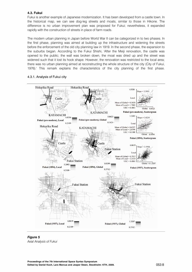
4.3. Fukui Fukui is another example of Japanese modernization. It has been developed from a castle town. In the historical map, we can see dog-leg streets and moats, similar to those in Hikone. The difference is no urban improvement plan was proposed for Fukui; nevertheless, it expanded rapidly with the construction of streets in place of farm roads. The modern urban planning in Japan before World War II can be categorized in to two phases. In the first phase, planning was aimed at building up the infrastructure and widening the streets before the enforcement of the old city planning law in 1919. In the second phase, the expansion to the suburbs began. According to the Fukui Shishi, 'After the Meiji renovation, the castle was opened to the public; the wall was broken down, the moat was dried up and the street was widened such that it lost its hook shape. However, the renovation was restricted to the local area; there was no urban planning aimed at reconstructing the whole structure of the city (City of Fukui, 1976).' This remark explains the characteristics of the city planning of the first phase. 4.3.1. Analysis of Fukui city
Figure 5 Axial Analysis of Fukui
Proceedings of the 7th International Space Syntax Symposium Edited by Daniel Koch, Lars Marcus and Jesper Steen, Stockholm: KTH, 2009. 053:9
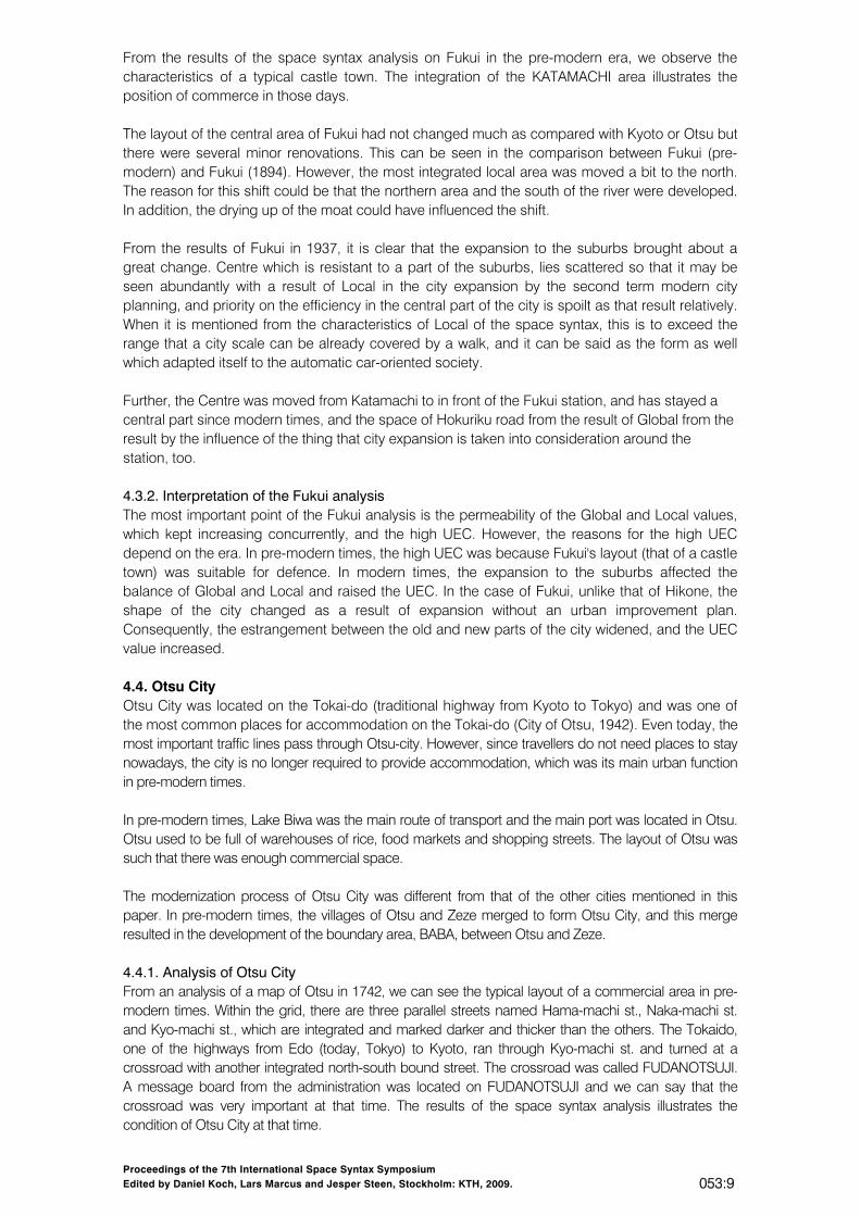
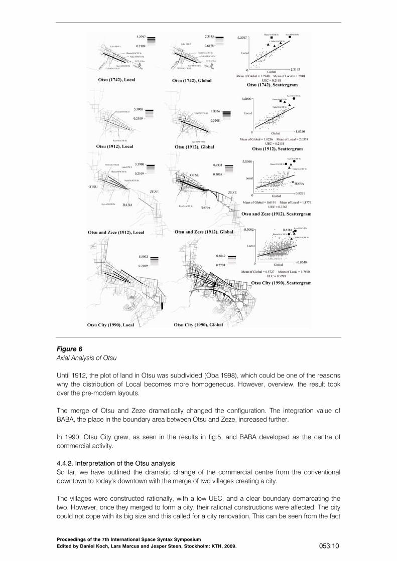
From the results of the space syntax analysis on Fukui in the pre-modern era, we observe the characteristics of a typical castle town. The integration of the KATAMACHI area illustrates the position of commerce in those days. The layout of the central area of Fukui had not changed much as compared with Kyoto or Otsu but there were several minor renovations. This can be seen in the comparison between Fukui (pre-modern) and Fukui (1894). However, the most integrated local area was moved a bit to the north. The reason for this shift could be that the northern area and the south of the river were developed. In addition, the drying up of the moat could have influenced the shift. From the results of Fukui in 1937, it is clear that the expansion to the suburbs brought about a great change. Centre which is resistant to a part of the suburbs, lies scattered so that it may be seen abundantly with a result of Local in the city expansion by the second term modern city planning, and priority on the efficiency in the central part of the city is spoilt as that result relatively. When it is mentioned from the characteristics of Local of the space syntax, this is to exceed the range that a city scale can be already covered by a walk, and it can be said as the form as well which adapted itself to the automatic car-oriented society. Further, the Centre was moved from Katamachi to in front of the Fukui station, and has stayed a central part since modern times, and the space of Hokuriku road from the result of Global from the result by the influence of the thing that city expansion is taken into consideration around the station, too. 4.3.2. Interpretation of the Fukui analysis The most important point of the Fukui analysis is the permeability of the Global and Local values, which kept increasing concurrently, and the high UEC. However, the reasons for the high UEC depend on the era. In pre-modern times, the high UEC was because Fukui's layout (that of a castle town) was suitable for defence. In modern times, the expansion to the suburbs affected the balance of Global and Local and raised the UEC. In the case of Fukui, unlike that of Hikone, the shape of the city changed as a result of expansion without an urban improvement plan. Consequently, the estrangement between the old and new parts of the city widened, and the UEC value increased. 4.4. Otsu City Otsu City was located on the Tokai-do (traditional highway from Kyoto to Tokyo) and was one of the most common places for accommodation on the Tokai-do (City of Otsu, 1942). Even today, the most important traffic lines pass through Otsu-city. However, since travellers do not need places to stay nowadays, the city is no longer required to provide accommodation, which was its main urban function in pre-modern times. In pre-modern times, Lake Biwa was the main route of transport and the main port was located in Otsu. Otsu used to be full of warehouses of rice, food markets and shopping streets. The layout of Otsu was such that there was enough commercial space. The modernization process of Otsu City was different from that of the other cities mentioned in this paper. In pre-modern times, the villages of Otsu and Zeze merged to form Otsu City, and this merge resulted in the development of the boundary area, BABA, between Otsu and Zeze. 4.4.1. Analysis of Otsu City From an analysis of a map of Otsu in 1742, we can see the typical layout of a commercial area in pre-modern times. Within the grid, there are three parallel streets named Hama-machi st., Naka-machi st. and Kyo-machi st., which are integrated and marked darker and thicker than the others. The Tokaido, one of the highways from Edo (today, Tokyo) to Kyoto, ran through Kyo-machi st. and turned at a crossroad with another integrated north-south bound street. The crossroad was called FUDANOTSUJI. A message board from the administration was located on FUDANOTSUJI and we can say that the crossroad was very important at that time. The results of the space syntax analysis illustrates the condition of Otsu City at that time.
Proceedings of the 7th International Space Syntax Symposium Edited by Daniel Koch, Lars Marcus and Jesper Steen, Stockholm: KTH, 2009. 053:10
Figure 6 Axial Analysis of Otsu Until 1912, the plot of land in Otsu was subdivided (Oba 1998), which could be one of the reasons why the distribution of Local becomes more homogeneous. However, overview, the result took over the pre-modern layouts. The merge of Otsu and Zeze dramatically changed the configuration. The integration value of BABA, the place in the boundary area between Otsu and Zeze, increased further. In 1990, Otsu City grew, as seen in the results in fig.5, and BABA developed as the centre of commercial activity. 4.4.2. Interpretation of the Otsu analysis So far, we have outlined the dramatic change of the commercial centre from the conventional downtown to today's downtown with the merge of two villages creating a city. The villages were constructed rationally, with a low UEC, and a clear boundary demarcating the two. However, once they merged to form a city, their rational constructions were affected. The city could not cope with its big size and this called for a city renovation. This can be seen from the fact
Proceedings of the 7th International Space Syntax Symposium Edited by Daniel Koch, Lars Marcus and Jesper Steen, Stockholm: KTH, 2009. 053:11
that the UEC increased from 0.2108 to 0.3763. In other words, the merger increased the UEC and resulted in the development of the boundary area. As a result, BABA became the commercial centre. Moreover, residential areas have been constructed in the grid and this mixture complicated the city even more. Consequently, the UEC value increased further. Although the high UEC resulted in the expansion and development of the city, a decline in the population and an urban problem, Otsu is not the exception. 4.5. Comparisons among the four JYOKAMACHI As shown above, the chronographic change in the indexes were different between the commercial castle towns and the defensive castle towns, even though both types of towns had expanded. From the index analyses of Kyoto, a commercial castle town, we realize that the expansion strongly influenced the permeability of the city. The case of Otsu City was also very interesting. It constituted a merge between Otsu, a commercial castle town, and Zeze, a defensive castle town. The Otsu could have predominance on the efficiency; however, Zeze became segregated by the merge. Hikone and Fukui, the defensive castle towns, experienced dissimilar patterns of modernization because renovation in the two cities differed. Hikone executed the urban improvement plan without expansion while Fukui expanded and its traffic efficiency decreased. In other words, Hikone renovated the conventional area but Fukui did not.
5. Conclusion
In the Japanese cities, the general idea of the castle wall enclosing the whole city was not common. In the age of feudalism, although there were no castle walls, there existed a boundary around cities. Within the boundary, the efficiency of the commercial castle towns like Kyoto and Otsu improved, and the defensive castle towns such as Hikone and Fukui aimed at low permeability for the purpose of defence. Modernization in Japanese urban history can be understood as the age of expansion. Kyoto and Otsu adjusted to the expansion shape comparatively easily. In contrast, Hikone needed to urbanize streets and Fukui could not bridge the gap between the conventional urban area and the suburbs. With respect to the question on whether the centre sets the boundary or the boundary leads the centre, the answer could be both of them. The efficiency of commercial castle towns was raised with the change in boundary, which was a direct change; thus, these towns were able to cope with new layouts. On the other hand, in the defensive castle towns, the conventional layouts influenced and changed the boundary, which seems to have negatively influenced the city from the viewpoint of traffic efficiency. The UEC index did not have much significance in the commercial castle towns but was rather significant in the defensive castle towns. For example, the UEC could show where the boundary should be established. For a sustainable compact city, the UEC needs to be maintained at a low value. The foundations of Japanese cities were laid within conventional boundaries. The vector of modernization was the collapse of the boundary. Attempts were made to solve today's urban problems, such as how to activate the central area of a city, without considering the whole structure of the city or the location of its boundary. The question of how to lead people to the centre should be understood where the boundary should be setup.
References City of Fukui. 1976. Shinshu Fukui Shishi [New revision of history of Fukui], City of Fukui (In
Japanese) City of Hikone. 1960. Hikone shishi Vol 1. [History of Hikone city], city of Hikone. City of Hikone. 1962. Hikone shishi Vol 2. [History of Hikone city], city of Hikone. City of Hikone. 1964. Hikone shishi Vol 3. [History of Hikone city], city of Hikone.
Proceedings of the 7th International Space Syntax Symposium Edited by Daniel Koch, Lars Marcus and Jesper Steen, Stockholm: KTH, 2009. 053:12
City of Kyoto. 1944. Kyoto Toshikeikaku Gaiyou [Outline of City Planning in Kyoto]. City of Kyoto. City of Otsu. 1942. Otsu Shishi [History of Otsu city]. city of Otsu (In Japanese). Conzen, M.R.G. 1980. Japanese and English Castle Towns: An Historico-Geographical
Comparison of their Morphology, in Conzen M.P. ed. Thinking about Urban Form. Peter Lang. Hillier, B. 1996. Space is the Machine. Cambridge University Press. Ishida, J. 2000. Kyoto no Kindaiga Motometa Kyojuu Kukan[Residential space Modern Kyoto urge
for]. Kindai Nihon no Kougaijyutaku[Modern Japanese Suburbs] Katagi, A. et al. (ed.), Kajima, pp.245-260.
Kigawa, T., and Furuyama, M. 2004. The Urban Entropy Coefficient: A measure describing urban condition. Journal of the City Planning Institute of Japan, No.39-3, pp.823-828.
Kigawa, T., and Furuyama, M. 2005. Kyoto — A morphological cycle between a city of rituals and a city of games, proceedings of 5th Space Syntax Symposium, Delft.
Kigawa, T., Seo, K.W. and Furuyama, M. 2007. The Significance of Modern Japanese City Planning. A Morphological Examination of the Land Readjustment Projects in Korea, Taiwan, and Japan. Proceedings of 6th international Space Syntax Symposium.
Nishikawa, K. 2007. Memory of Jyokamachi [Jyokamachi no Kioku]. Sunrise Publishing, Hikone, Japan.
Sorensen, A. 2002. The Making of Urban Japan, RoutledgeCurzon. Stegen, G.M. 1999. Qualitative descriptions of urban clusters. Proceedings of 2nd Space Syntax
International Symposium, Brasilia. Takahashi, Yasuo and Yoshida, Nobuyuki (eds.) . 1989. Nihon Toshishi Nyumon, Vol.1, Univirsity
of Tokyo Press.