Embed Size (px)
Citation preview
UTAH GEOLOGI01L
{'1' QUARTERLY REVIEW MINERALOGI 01 L
SURVEY Vol. 7, No. 1 Service to the State of Utah February 1973
UGMS FOREWARNS
Earth Failures Menace 1-80 Last August along Interstate
Highway 80 between Coalville and Echo in Summit County, a portion of the road cut failed - the second such occurrence along that stretch since the road was first opened t6 traffic.
At least two years prior, Utah Geological and Mineralogical Survey staff had photographed the lanes, before and after being opened to traffic , and had predicted landsliding (see top picture taken from UGMS' Earth Science Education Series No. 2, published February 1971).
Below: The second slide between Coalville and Echo in Summit County, Augu st 1972. Left center : Farther north along the same highway, en echelon tension cracks portend future problems. Right center : Excavation of the slide foot revealed this scarplet with a clearly deformed (differentially shored) claystone horizon; the cone-in-<:one structure (arrow) is believed penccontemporaneous with most of the deformation. Splintering, which already is destroying the structure, follows the fluting and slickensides in orientation.
A third massive earth failure in December 1972 covered the westbound lane of traffic and required snowplows to clear the area. The slide was entirely in fill embankment material. Drill rig equipment is being used to explore subsurface conditions to provide data for a solution to the problem.
Above : View along newly opened traffic lanes ; notch cut in slope is the result of a failure onto the road. Landsliding was predicted. (All photos by B. N. Kaliser , UGMS.)
(Page 2
More than 3 million gallons of water are pumped daily at Bountiful City's new well.
CITY INSTALLS PUMP
QUARTERLY REVIEW
Kaliser checks Peterson Brothers' truckmounted pump equipment.
Bountiful Well Boosts Water Supply The City of Bountiful has a
new water well, gauged at flowing 2,225 gallons per minute maximum pump capacity. The rate of 3,204,000 gallons of water per day provides a terrific boost to Bountiful's supply of water to serve the community.
Bruce N. Kaliser, UGMS engineering geologist, recommended siting the well at the mouth of Barton Canyon at the east end of
6th South, an elevation considerably above the greater urban area, to avoid filtration, evaporation and pressure loss problems; he also supervised the drilling operation.
Peterson Brothers Drilling Co. of Bountiful drilled the well to 550 feet and installed a pump. Water will be drawn into the city water reservoir for dispersal.
Oil Shale-Possible Energy Source "Oil shale and oil-impregnated
rocks," presented by H. R. Ritzma, UGMS petroleum geologist, at the 1972 annual meeting of the American Association of Petroleum Geologists, will be published in the proceedings of the Mineral Economics Symposium (AAPG) by the Mineral Economics Institute, Colorado School of Mines.
The paper describes the oil shale and oil-impregnated rock resources of the U. S. and, in particular, the oil shale of Colorado, Utah and Wyoming and Utah's oil-impregnated rock.
The magnitude of these resources and their possible exploi-
tation as energy sources is discussed. Both oil shale and oilimpregnated rocks (tar sands) are predicted to contribute to the nation's supply of synthetic petroleum by 197 5 and in significant amounts by 1985.
In addition to the paper by Ritzma, the volume will contain articles oi;i mining and mineral policies, petroleum, natural gas, coal and uranium by authorities in each field.
Copies are to be sold by: Publications Department, Colorado School of Mines, Golden, Colorado 80401. Price is $3.00 per copy payable by check or money order.
February 197 3)
Utahns Mourn Armand J. Eardley
Dr. Armand J. Eardley, professor emeritus, Department of Geo I ogical and Geophysical Sciences, University of Utah, died November 7, 1972 at his home of a heart ailment.
Dr. Eardley, former dean of the College of Mines and Mineral Industries at the University for 11 years, was also head of the Department of Geology. He was president of the Rocky Mountain Section of the American Association of Petroleum Geologists and a member of the Utah Geological Society and other professional organizations.
He was the recipient of several awards honoring him as a scientist, scholar and teacher, i.e., the James E. Talmage Scientific Achievement Award in 1963 from Brigham Young University and meritorious service award in 1956 from the Utah Academy of Sciences.
Although he had exceptionally wide interests and published papers of global scope, he maintained especiai interest in the geology of the Salt Lake area. His studies of the waters, sediments and environ of Great Salt Lake are world famous.
At the time of his death, he was actively engaged in a joint study, financed by the National Science Foundation, of a deep core from the Great Salt Lake.
In eulogizing Dr. Eardley, one colleague said if ever there was a man to emulate, it was Dr. Eardley, because he was, in the true sense, a gentleman and a scholar.
The Utah Geological Survey joins with his friends and associates in mourning the loss of a great man. ·
(February 1973
UGMS RELEASES NEW SERIES
The first studies in a new Oil and Gas Field series were released this month by UGMS. Nos. 1 and 2, Pariette Bench Field and Agate Field Area, are in Uintah and Grand counties; No. 3, Grassy Trail Creek Field, straddles the Carbon-Emery county line.
A map depicting the structure of the field, stratigraphic data where significant to production , and a type log-usually electric or gammaray-neu tron-cover each field, with one or more cross sections for larger fields.
Accompanying text details the field's discovery, development, reservoir data and production statistics and describes its geology.
The series begins with fields discovered and developed since 1961, but ultimately will update and supplement older data (i.e. , the Intermountain Association of Petroleum Geologists' Guidebook, Oil and Gas Fields of Utah - A Sy mposium).
Work on fifteen fields is underway or has been completed by P. R. Peterson, consulting geologist , under con tract to the Survey.
Maps, charts and text are folded in to an envelope for convenience in filing or binding in a looseleaf. The first three studies are $1.00 each over-the-counter, $1.10 by mail (Utah Survey, 103 UGMS Bldg., University of Utah, Salt Lake City, Utah 8411 2).
Utah's Sen. Frank E. Moss, chairman of the Subcommittee on Minerals, Materials and Fuels, was appointed chairman of the Committee on Aeronautical and Space Sciences and will no lohger serve on the Interior Committee. A new subcommittee chairman has not been chosen.
QUARTERLY REVIEW Page 3)
Hollis Dole Resigns Federal Post President Nixon has accepted
the resignation of Hollis M. Dole, Assistant Secretary of the Interior (Mineral Resources). A professional geologist, Dole joined the Nixon Administration on March 21, 1969.
Dole held major responsibilities for federal policies and programs related to energy and mineral resource development ; he was among the first administration officials to call attention to the nation's deteriorating energy situation . He was instrumental in securing the passage of the Mining and Minerals Policy Act and the Geothermal Steam Act, and in carrying out significant portions of President Nixon's Clean Energy
. program.
t't'Trickl,e-Root" System
Implemented in U. S.
An agreement between S. Blass, originator of trickle-root irrigation in Israel, and H. Klein , Washington, D. C., to market the trickleroot system in the U. S. may be a crucial development in water management.
Present estimates of withdrawals for irrigation in 1980 run as high as 136,000 million gallons daily , with consumptive use projected at 82,000 million gallons daily (Water Newsletter, v. 14, no. 8, 1972). Amounts for 1965 were 111 ,000 and 65,000 million respectively. In a nation which uses the equivalent of about 1,800 gallons of water per person each day to serve its homes, farms and factories, cutting back irrigation demands is a major shift in the direction of sensible water budgeting.
As stated by the American Mining Congress, Dole's record as both a state and federal official reflects a philosophy of making public resources available for development by private enterprise.
He has consistently sought to increase the number of mining engineers being graduated and to upgrade the capabilities of mineral science colleges through programs of federal assistance.
Dole is a graduate of the College of Mines, University of Utah , and an honorary member of the Association of American State Geologists. From June 19 5 5 until March 1969 he was Oregon's state geologist and acted in that position from January 1954 to June 1955. The UGMS salutes him for his accomplishments .
Although some areas in the U. S. presently use the drip watering method, the agreement paves the way for large-scale implementation with "tens of thousands of acres of various row crops and orchards exploiting this system throughout the United States"-using 30 percent less water to grow crops twice as large as those now grown with conventional irrigation techniques.
The Blass method reportedly helps stem pollution by eliminating the irrigation flooding of land with its consequent dumping of sediment-laden water and chemicals from fertilizers in nearby streams.
A fixed plastic network incorporating a fertilizer control head , main filters , mainpipes and dripping lines is placed on the soil to feed sufficient water and nutrients to "grow fruit not roots." Crop watering is planned at predetermined rates sufficient to
(continued on page 7)
(Page 4 QUARTERLY REVIEW
Mineral Production in Utah, 1971-1972
by Carlton H. Stowe, UGMS Staff Specialist
During 1972, Utah's mineral industry accounted for more than 20 percent of the assessed valuation for the en tire state, or $403,196,468, an increase over 1971 's $402,538 ,800.
Utah collected more than $35 million in taxes from mineral producers: +$2. 9 million in state royalties, +$28.6 million in property tax ( 17.07 percent of total), +$3. 8 million in occupation tax, and corporation and sales taxes.
In 1972, the Bureau of Land Management administered 22,722,316 acres (43.12 percent) of Utah's 52 ,696,960 acres. Largest contributor of receipts from ELM-administered lands and resources during fiscal 1972 came from the Mineral Leasing Act of 1920: $10,035,591 (89.25 percent) of the total $11 ,244,294; although total receipts were larger
in 1972 than 1971, mineral leasing provided 90. 7 percent of the total in 1971.
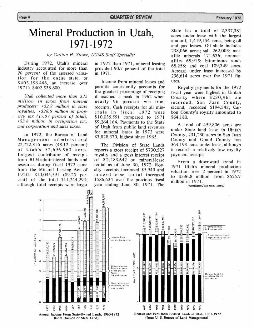
Income from mineral leases and permits consistently accounts for the greatest percentage of receipts; it reached a peak in 1962 when nearly 96 percent was from receipts. Cash receipts for all miner al s in fiscal 1972 were $ I 0,035,591 compared to 1971 $9,264,164. Payments to the State of Utah from public land revenues for mineral leases in 1972 were $3,828,370, highest since 1965.
The Division of State Lands reports a gross receipt of $730,527 royalty and a gross interest receipt of $2 , 183,642 on mineral-lease rental as of June 30, 1972. Royalty receipts increased $5,940 and mineral-lease rental increased $586,634 over the previous fiscal year ending June 30, 1971. The
~n ""WV (")
V, Cl::
("). (X) a,
10 .--------------:- -- ~--
(fl ~ -
(X)
9 t-----------~ -(").
(")
a, °'· N ,-...
8 1--------~-~-a, <D
(X)
a,
,-...
~ 1----00--------cc~ (") <D.
~
...
(fl I'!"":":": ....
r- ~ - \~!! f-r--.. ..• oo·
~
-- ::: r- ::::
I ncome from ► <:( ,-... ,:
-.J 6 -----j ~N- :: - : : :: r-- :::: ~ b on d s. loans , etc . -.J (") .n" ::
g ~- ~ . ;g,.... ~- i r---. en_ :
l..l. N tO :::_;·_ -E:::-- ~:~: :: t--a 5 .--~.-~_- ! ~ V, V> .,.
§ !!!,
-- ::: ,-- :: :: ._
:j 4 r-- - ::: .,__ :: : - :: ,-- ::; r-- ::: r-
~ ..
3 ,- ~ :::: 1-- ::: ~ ·· ~ :: ::--- = = -- ~ ) -~
2 ,-_ i I I •
1 r-
[
G ra71nij leases . R ,ghts a l w ay . Stat e -o w ned fa r m s , Sale of timb e r
M 1nPra l Inc o m e ► royalties . lease s
and ren l als
-.J -.J
~
February 1973)
State has a total of 2,337,381 acres under lease with the largest amount, 1,419, I 54 acres, being oil and gas leases. Oil shale includes 238,066 acres; salt 262,003; metallic minerals 171,636; nonmetallics 68,915; bituminous sands 68,258; and coal I 09,349 acres. Acreage under lease increased by 236,614 acres over the 1971 figures.
Royalty payments for the 1972 fiscal year were highest in Uintah County where $ 2 3 0, 9 6 1 are recorded. San Juan County, second, recorded $194,542; Carbon County's royalty amounted to $64,180.
A total of 459,806 acres are under State land lease in Uintah County, 231 ,230 acres in San Juan County and Grand County has 364,198 acres under lease, although it records a relatively low royalty payment receipt.
From a downward trend in 1971 Utah's mineral production valuation rose 2 percent in 1972 to $536.8 million from $525.7 million in 1971.
..;.;..·
(continued on next page)
Gra zin g re nta ls and t imber sal es
F ees , co mm,ss,ons
r ight of wa y rental s
M inera l In come roya ltie s, leases an d r e ntals
0 -0 L...a.__. ________ ~a__J--------~...._.__,_
Annual Income From State-Owned Lands, 1963-! 972 (from Division of State Land)
Rentals and Fees from Federal Lands in Utah, 1963-1972 (from U. S. Bureau of Land Management)
(Febru~ry 1973
(continued from page 4)
In preliminary data the U. S. Bureau of Mines reports that production in the metals group remained about the same in I 972 as in 1971 and accounted for 65 percent of the total value. Production of mineral fuels increased 5 .6 percent and accounted for 25 percent of the value, while nonmetals increased 8.2 percent to about I 0 percent of the value.
Largest increase noted is in gold which rose to $21,391,000 in 1972 compared to 197l's $15,221,000. Production in 1972 was less than 1971 (367,155 compared to 368,996 troy ounces). Copper rose to $274,299,000 over $273,989,000. Because of the tremendous increase in oil explora-
QUARTERLY REVIEW
tion, primarily in the Uinta Basin area, petroleum climbed to $79,648,000, hlghest since 1963 when the mark was set at $90.9 million. Marketed natural gas, however, fell from $7,084,000 in 1971 to $7,020,000 in 1972.
At the end of 1972, oil and gas operating companies and independent operators had drilled 159 wells in Utah compared to 90 wells drilled in 1971-86 were exploratory whereas 56 were exploratory in 1971.
Utah's 1972 well completions include:
New field wildcats: IO oil, 2 gas, 56 dry for a total of 68 wells. Footage drilled, 458,863 feet. Other exploratory wells: 12 oil, 6 dry for a total of 18 and 195,715
Page 5)
feet drilled. Includes new pool, deeper pool, shallower pool, outpost and extension tests. All wells drilled for oil and gas: 7 5 oil, 13 gas, 71 dry for a total of 159 wells. A grand total of 1,292,374 feet of hole was drilled for the year.
Note: Federal and state mineral statistics related to leasing and royalties are maintained on a fiscal year basis; data apply to the fiscal year July 1, 1971 to June 30, 1972. U. S. Bureau of Mines reports, however, are on a calendar year basis. Mineral production and values by county for 197 2 will be included in May's Quarterly Review.
Information for this report was derived from the following sources: U. S. Bureau of Mines 1971 annual yearbook data, 1972 preliminary data and additional information released to UGMS by the USBM; Public Land Statistics, 1971, Bureau of Land Management; BLM Facts and Figures for Utah, 1972, and Utah Division of State Lands fiscal report, July 1, 1971 to June 30, 1972.
Utah lands fees, royalties, rentals, fiscal year data 1967-1972.
1967 1968 1969 1970 1971
FEDERAL
Minerals 8,413.,371 "7,998,034 8',662,523 8,022,666 9,246,164 Grazing 445,606 41'6,165 450,874 570,172 660,371 Others 322,963 315,227 284,538 55,292 287,602
Total 9, I 81,940 8,729,426 91397,935 8,648,130 10,212,137
STATE
Minerals 1,979,388 2,312,647 2,406,454 2,373,514 2,321,596 Grazing 151,130 156,898 172,386 183,291 193,396 Others 2,964,753 4,724,084 5,354,268 11,836,688 5,273,717
Total 5,095,271 7,193,629 7,933,108 14,393,493 7,788,709
Minerals activity on federal lands in Utah, July 1, 1971, to June 30, 1972 (U.S. Bureau of Land Management)
Mineral permits and Licenses Mineral Leases
Commodity No. I Acres No. I Acres Production Petroleum 1,383 1,329;521 13,412 9,686,581 10,561,959 Natural gas 26,623,751 Oil and gas liquids 51,976,219 Coal 0 0 241 405,355 2,281,418 Other
Potash 38 75,772 74 133,547 Phosphate 1 322 18 · 25,94Q Gilsonite and
bituminous sands 0 0 15 J,546 Carbon dioxide 63,087 Silica sand 13,8'29
Totals 1,422 1,405,615 13,760 10,254,969 (7-1-70 to 6-30-71) 1,626 2,153,464 15,184 9,487,982
1972
10,035,591 731,342 477,361
11,244,294
2,914,169 208,031
6,131,983
9,254,183
Receipts Leases, Permits
$8,575,974
593,731 . 25,436
55,6'~1 13,371
9,,264,163 8,646,079
I Royalties $4,722,553
507,955 22,335 44,392 12,979
5,310,214 4,926,712
Total receipts from leases and permits on public lands in fiscal year 1972 include royalties on Federal leases collected by U.S. Geological Survey: $10,035,591.
Allocation of Bureau of Land Management receipts to State of Utah for mineral leases and permits: $3,828,370. Source: Bureau of Land Management Facts and Figures for Utah, 1972. (continued on next page)
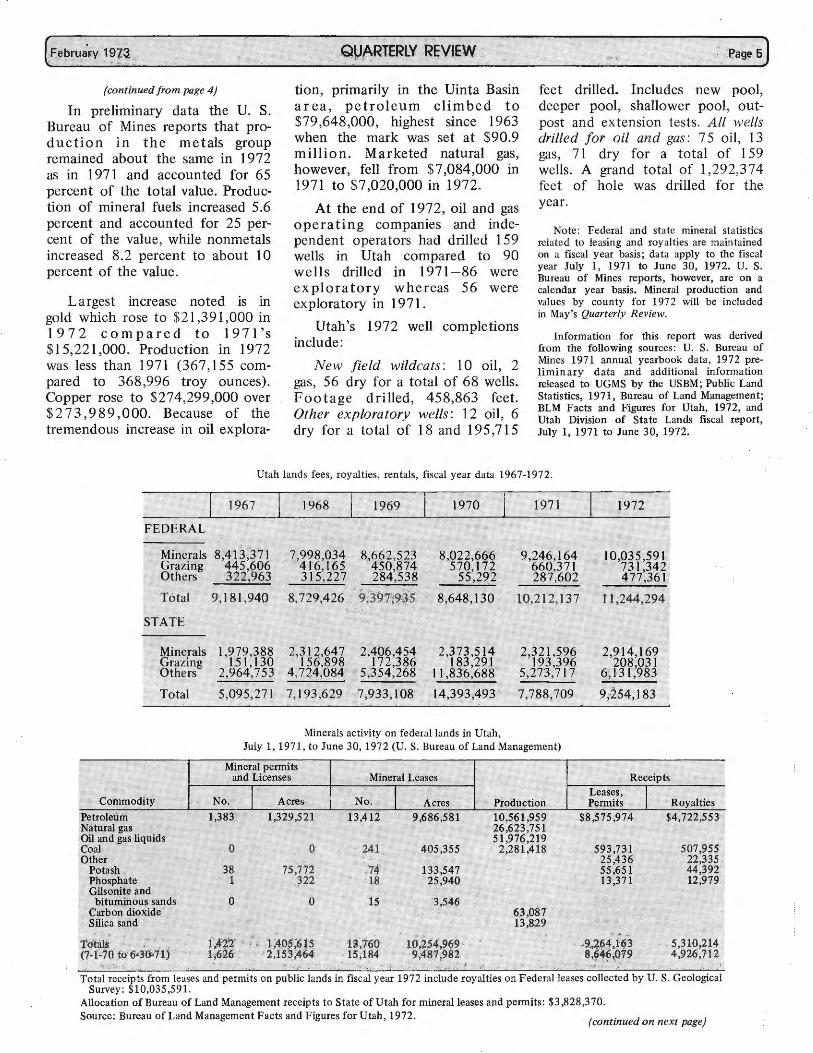
San Arroyo Field
StudyO o
Title still h Govern men el d by U. S 300 000 t (roughly . (continued fi rom page S)
WATER LAND l,64928 52 6 ' O Acres ' acres)
n pen File TOTAL • 96,960 Acres
54,346 240 • Acres
M = Million
A stud b Geolo y Y 0. A M
fi Id
gy of the s · onsalve e ' Grand an Arroyo gas'
open f" l Coun ty Ut h 1 e at U , a , is on
FEE LANDS
21% = 11 .1 M Acs.
e o ogical Survey. tah G
1
The stud stratigraph Y covers the accumulation Y' structure the San A of natural and Utah's 1 rroyo field gas in argest , one of series of gas producers A anticlinal stru~t~~s depicts . the several levels and e of the field of and thickness t~e areal extent sandstone b d o each majo faulting on t: y. Large-seal r San A e north fl e b rroyo anticli ank of D~ff de tailed struc~e was revealed
1 erence . ural ma . . s m th ppmg m the field are d . e gas produced iscussed.
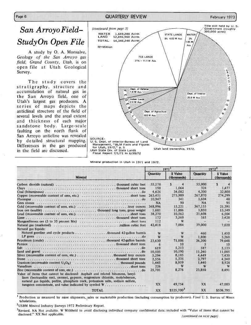
Carbon dioxid ( Mineral Oays . . e natural) . Coal (bitu · : · · · · · · · • . · · · · · · · · · · • . c nunous) · · •. . . . · · • ...
opper (recover bl· · · · · · • . · · · · · · · • . · · · · · · · · • thou Fluorspar . a e content of . . . . . . . . . . . . ........ ... th sand cubic feet Gem stone,' . . . . . . . . . . . . ores, etc.) ... : ............. ousand short tons
Gold ( · · · ·. · · · · ·. · · · · · . · · · ·. recoverabl · · · • . . . . · · · • . . . . · · · · . . · · · · • do Iron ore ( e content of · · · · . . . . · · · · • . . . · · · · .short to Lead ( usable) . . . ores, etc.) · · • . . . . . . . . · · . . . . . . . . . ns L' recoverable · · • . . . . . . · · • . . . . . . · · • . . . . . . · · • . do
1me . . . content of ore . . . . . . . . . . . . . . . . . . ..... . Manganife. . . . . . . . . s, etc.). . . .... thousand lo ....... troy ounc .. N rous ore (5 • . . . . . • • . . . ng tons es atural gas ( to 35 per · · · · · . . . . . · · · · · · . . . . . • gross weight Natural gas tarketed) . . cent Mn) ................. th ..... short tons
Na tu 1 qmds: . . . . . . . . . . . . . . . . . . . . . ousand short t ra gasoline . . . . . . . . . . . . . . . . . . sh ons
LP gases and cycle prod .......... miili . . ort tons
Petroleum (c;.,d· . . . . . . . . . . ucts . . . . . . . on cubic feet Pumice e) · • . . . · · · · · · · : : · · · · · thousand 42- . Salt . . . . . .. : : : · . . . . . . · · • . . . . . . . gallon barrels Sa d . · · . · · .. · th ... ·
Sil
n and gravel· · · · · · ....... : · · · · • ....... : · · · · ousand 42-;,
1· · · · · . do
ver (re · · • . · · · . · · · • th c"-' on barr l St coverable . . . . . . . . . . . . . . . . . . . . ousand h es one . . content of
O
• • • • • • • • • • • • • • • • • • s ort tons U · · · · · res etc) · · · • · · • raruum (re . . . • . . • . . . . . • . . . . . . . . . . do Vanadium ~overableco~t~i'U ·o .) ..... : : : : : ........ : :th~~;.· d ..... : :do Zmc (r . . . . . 3 8 • . . . • n troy ou
Val~: :t:::~~let~:f if i ~f·,;;;s, ~t~:). : : : : : : : : : : : : : : : : : : : th_o;;:::a~~ort ;~:, m (bertrand· nnot be discl _- · • . . . . . . · · · . . . . . . . pounds
natural gas liqu1~ed ore), cement gosed. Asphalt and .. 1· • • • • • . • • • • short tons tung t • s pe li • ypsum re ated b' · · · .. s en concentr;te r ~e, phosphate r~ ~agnesium chlorid itumens, beryi_- .. do
• an value indicated\• potassium salts e, m?lybdenum
55,178 198
4,626 263,451
10,947 NA
368,996 1,681
38,270 172 112
42,418
w w
23,630 6
619 10,505
5,294 2,556 1,445
226 25,701
4 1,064
34,082 273,989
341 90
15,221 11,886 10,562
3,569 w
7,084
w w
71,886 10
5,213 10,190
8,185 5,335 8,959
w 8,276
55,000 324
4,300 267,870
1,604 NA
367,155 1,850
21,608 165
-39,000
460 1,800
26,200 5
587 11,240 4,449 2,797 1,440
w 23,850
$ 4 1,477
32,800 274,299
48 95
21,391 13,149 6,504 3,420
7,020
1,450 3,260
79,648 10
5 ,123 11,005
7,430 4,240 8,928
w 8,491
47,003 • y symbol W. · .. '. sodium sulfate:
Production tabulations as measured by . TOTAL XX 2 • mrne shi 49 US BM M. pments sal , 7 54 3 mernl In dust , I es or marketabl XX XX Revised. NA ry Surveys 1972 . e production (in . $525,700'
disclosed." xr~ available. W Withh Preliminary Report cludmg consumption b XX ot applicable eld to avoid d. . Y producm) r· · 1sclosing • d.. .. mal U s m IVldual co . . Burnau of M
mpany c fi mes on idential d· , . ata; included with " V· l a ue of items th ·
(continued <It canno t be on next page)
(February 1973
(continued from page 6)
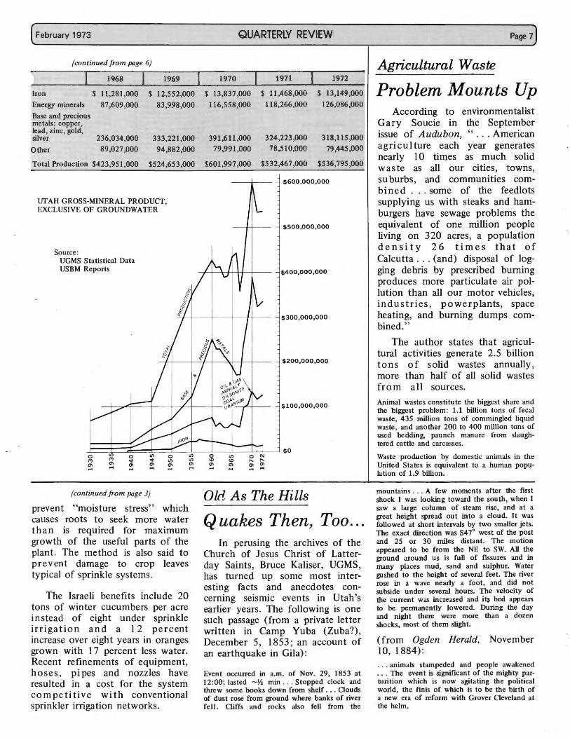
1968
Iron $ 11 ,281,000
Energy minerals 87,609,000
Base and precious metals: copper, lead, zinc, gold, silver 236,034,000
Other 89,027,000
1969
$ 12,552,000
83,998,000
333,221,000
94 ,882,000
Total Production $423,951 ,000 $524,653,000
UTAH GROSS-MINERAL PRODUCT, EXCLUSIVE OF GROUNDWATER
Source: UGMS Statistical Data USBM Reports
QUARTERLY REVIEW
1970
$ 13,837,000
116,558,000
391,611,000
79,991,000
$601,997 ,000
1971 1972
$ 11,468,000
118,266,000
$ 13,149,000
126,086,000
324,223,000
78,510,000
$532,467,000
318,115,000
79,445,000
$536,795,000
$600,000,000
$500,000,000
$400,000,000
$300,000,000
$200,000,000
$100,000,000
Jo====~t=:~o~~~~~~o±::::=..__J~ _ _Jo _ _J~=~ o~N~-_j $O ('I') ('I') <:t <:t ~ ~ \0 \0 r-- r--0\ O'I O'I O'I O'I O'I O'I O'I O'I O'I .... .... .... .... .... .... .... .... ........
(continued from page 3)
prevent "moisture stress" which causes roots to seek more water than is required for maximum growth of the useful parts of the plant . The method is also said to prevent damage to crop leaves typical of sprinkle systems.
The Israeli benefits include 20 tons of winter cucumbers per acre instead of eight under sprinkle i rr i g at ion an d a I 2 percent increase over eight years in oranges grown with 17 percent less water. Recent refinements of equipment, hoses , pipes and nozzles have resulted in a cost for the system competitive with conventional sprinkler irrigation networks.
Old As The Hills
Quakes Then, Too ... In perusing the archives of the
Church of Jesus Christ of Latterday Saints, Bruce Kaliser, UGMS, has turned up some most interesting facts and anecdotes concerning seismic events in Utah's earlier years. The following is one such passage (from a private letter written in Camp Yuba (Zuba?), December 5, 1853 ; an account of an earthquake in Gila):
Event occurred in a.m. of Nov. 29, 1853 at 12:00; lasted ~½ min . . . Stopped clock and threw some books down from shelf ... Oouds of dust rose from ground where banks of river fell. Cliffs and rocks also fell from the
Page 7)
Agricultural Waste
Problem Mounts Up According to environmentalist
Gary Soucie in the September issue of Audubon, " ... American agriculture each year generates nearly 10 times as much solid waste as all our cities, towns, suburbs, and communities combined ... some of the feedlots supplying us with steaks and hamburgers have sewage problems the equivalent of one million people living on 3 20 acres, a population density 26 times that of Calcutta ... (and) disposal of logging debris by prescribed burning produces more particulate air pollution than all our motor vehicles, industries , powerplants, space heating, and burning dumps combined."
The author states that agricultural activities generate 2.5 billion tons of solid wastes annually, more than half of all solid wastes from all sources.
Animal wastes constitute the biggest share and the biggest problem: 1.1 billion tons of fecal waste, 435 million tons of commingled liquid waste, and another 200 to 400 million tons of used bedding, paunch manure from slaughtered cattle and carcasses.
Waste production by domestic animals in the United States is equivalent to a human population of 1.9 billion.
mountains . . . A few moments after the first shock I was looking toward the south, when I saw a large column of steam rise, and at a great height spread out into a cloud. It was followed at short intervals by two smaller jets. The exact direction was S4 7° west of the post and 25 or 30 miles distant. The motion appeared to be from the NE to SW. All the ground around us is full of fissures and in many places mud, sand and sulphur. Water gushed to the height of several feet. The river rose in a wave nearly a foot , and did not subside under severai hours. The velocity of the current was increased and it~ bed appears to be permanently lowered. During the day and night there were more than a dozen shocks, most of them slight.
(from Ogden Herald, November 10, 1884): . .. animals stampeded and people awakened ... The event is significant of the mighty parturition which is now agitating the political world, the finis of which is to be the birth of a new era of reform with Grover Cleveland at the helm .
QUARTERLY REVIEW February 1973)
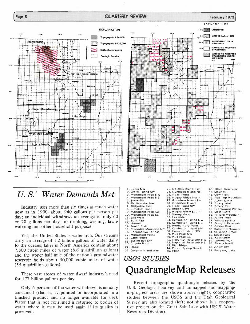
EXPLANATION
EXPLANATION
D Topographic 1 :24,000
Q Topographic 1:125,000
~ Orthophotomappin9
D Geologic Division
~F?J)f:Vslf-
1. 5% . UNMAPPED
.,.~5 % ~ MAPPED (before 19401
2 4 % mm ~~b~~~~ED OR IN
74%□ ~~=~Ec°A1i:ccEPTED -MAPPED TO ACCEPTED STANDARDS, UNDER REVISION
,, • .I..
U.S.' Water Demands Met
Industry uses more than six times as much water now as in 1900- about 940 gallons per person per day ; an individual withdraws an average of only 60 or 70 gallons per day for drinking, washing, lawnwatering and other household purposes.
Yet , the United States is water ri ch. Our streams carry an average of 1. 2 billion gallons of water daily to the oceans ; lakes in North America contain about 7,800 cubic miles of water (8. 6 quadrillion gallons) and the upper half mile of the nation 's groundwater reservoir holds about 50,000 cubic miles of water (5 5 quadrillion gallons).
These vast stores of water dwarf industry's need for 1 77 billion gallons per day .
Only 6 percent of the water withdrawn is ac tually consumed (that is, evapora ted or incorpo ra ted in a fi nished product and no longer available for use). Water tha t is not consumed is retu rned to bodies of wa ter where it may be used again if its quality is preserved .
,,,.I. ,,Jw.
1 . Lucin NW 23 . Dolphin Island East 46 . O lsen Rese r vo ir 2. Crater Island SW 24. Gunniso n Island NE 47. M o unds 3. Monument Peak NW 25. Ro zel Point 48. Co w Flats 4 . Monument Peak NE 26 . Hogup Ridge North 49 . Fla t T o p M ou nta i n 5. Snowville 27. Gunniso n Island SW 50. A cor d La k es 6. Rattlesnake Pass 28 . Gunniso n Island 51 . Emer y West 7. Ridgedale Pass 29 . Ro zel Poin t SW 52. Emer y East 8 . Limekiln Knoll 30 . Indian C o ve 53. Old W o m an Pl at ea u 9. Monument Peak SW 31. Hogup Ridge s o uth 54 . M esa Butte
10. Monument Peak SE 32. Strong Knob 55. Hilgard M o untai n 11. Salt Wells 33. Lakeside 56. John's Pea k 12 . Bulls Pass 34. Ca rr ington Island NW 57. W i ll o w Spri n gs 13. Howell 35 . Ca rri ngton Island NE 58. F orsy t h Reser vo i r 14. Peplin Flats 15. Crocodile Mountain NE 16. Locomot i ve Spri ngs 17. Monument Poi n t
36. Promont o ry Po i nt 37. Carrington Island SW 38 . Frem o nt Island SW 39 . Plug Pea k NW
59. Geyser Pe ak 60. Solomons T em pl e 61 . Sa lvat ion Creek 62 . S il ve r Falls
18. Lake Ridge 19. Spr ing Bay SW 20 . Coyote Po int
21 . Ro zel
22 . Dolphin Island West
40. Plug Peak S E 41 . N e ponset Rese r voi r NW 4 2. N e po n set Reser voir N E 43 . F la t R i dge 44. Po iso n Spri ng Ben c h 4 5. Elmo
63. K oosharem 64 . M oro n i Peak 65. Flossie Kn ol l 66 . An timon y 67. Po l l y w o g L ake
USGS STUDIES
Quadrangle Map Releases R ecent topographic q uadrangle releases by the
U. S. Geological Survey and unm apped and mapp ingin-progress areas are shown above ( righ t) ; cooperat ive studies betwee n th e USGS and th e Utah Geologica l Survey are also Ioca ted (left ; no t show n is a cooperati ve project o n th e Grea t Salt Lak e with USGS' Water Resources Di visio n).
--~ E
Gentlemen:
This is our yearly request for help from you. Inquiries regarding Utah geology often involve areas where there is no published geologic coverage, but on which there has been geologic field work. Therefore, the Utah Geological and Mineralogical Survey hereby solicits your cooperation for our open file listing of those areas being studied by professors and students or agencies. The Survey requests that you circulate this form among your staff and graduate students so it may be filled in and returned. Information supplied by respondents will be published in the Quarterly Review and should be submitted not later than March 31.
Your general knowledge of studies being conducted by other organizations or universities is also requested.
Some of the information solicited may be contingent on future decisions. Please do not withhold that which is available pending more definite plans. Our compilation must be timely if it is to be meaningful.
Where possible, please indicate on the map on the other side of this page the areas covered or to be covered.
Yours truly,
William P. Hewitt, Director Utah Geological and Mineralogical Survey
Organization _______________________________________ _
Name of chief investigator _________________________________ _
Address ________________________________________ _
Subject of thesis _____________________ or study ____________ _
Geographic area _____________________________________ _
Location by township ___________________ Range _____________ _
Latitude Longitude ______________ _ (Please also note location on reverse side on map)
Scope and class: (i.e., detail, reconnaissance , photo interpretation with or without field checking, etc.)
Pertinent information: (i.e., special techniques, methods, map scales, cooperating agencies, commodities, etc.)
Dates: Inception ________________ _
Projected· completion ___________ _
Probable location of information: (i.e., thesis file only, where, publication agency, etc.)
Probable status on completion: (i.e., University thesis; open file-where; state agency-where; publication-where ; company confidential-release date and provision, where)
Please return this form to: Utah Geological and Mineralogical Survey, 103 UGS Building, University of Utah, Salt Lake City, Utah 84112, Attn: Editorial Department.
<[
0
<[
>
w
z
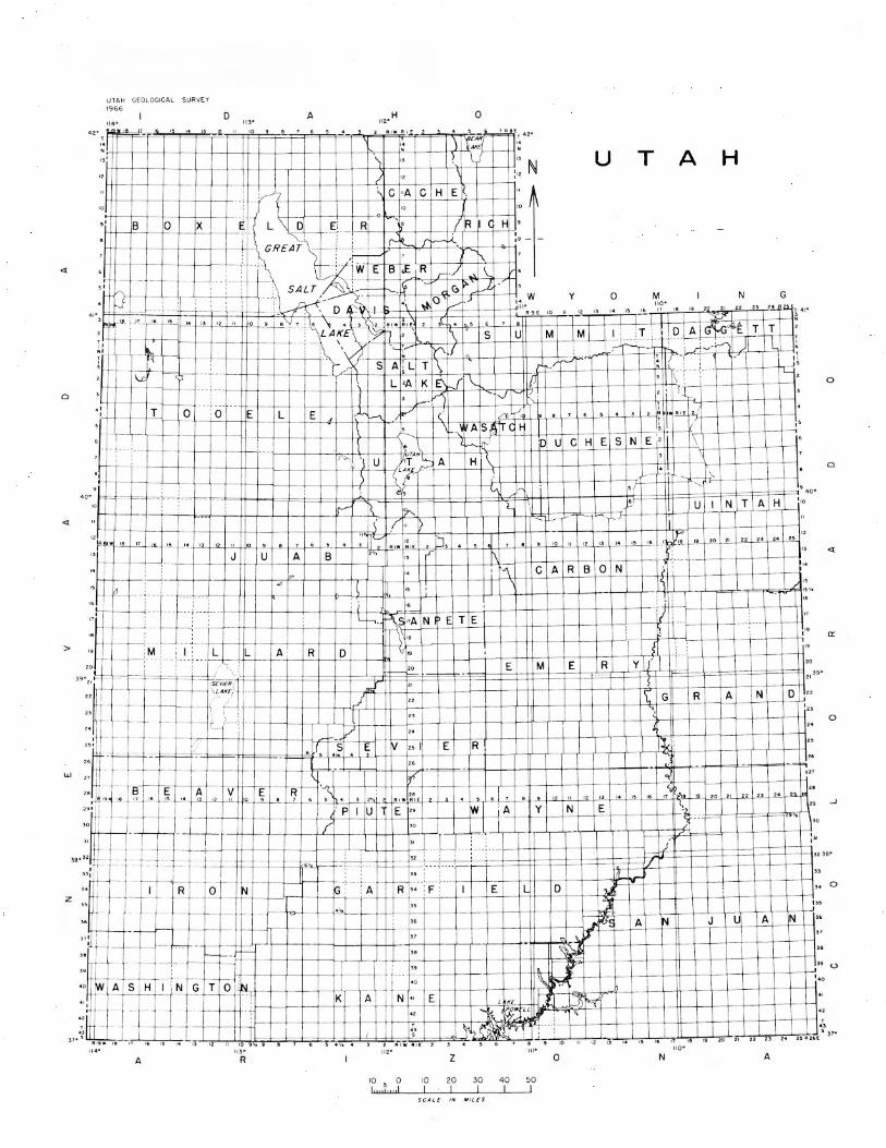
UTAH GEOLOGICAL SURVEY !966
D
•r' rr+B--+----1-0-+-+x- l--+-t i
ii • ,, ,~ G
A 0
u T A H
N G
•' T I 1-'--i---1r0~·-··T: 0~-+· --+~E+ ~ L=+--+'E~4-+~··..l.-=1HQ~/iV:__J_-tJCJ' ~k-k~/Y2''~2J'H-\4L4-'-+~-'-l-'---\-'--H' ~ ., ,uR '-'-t'-'-1 , :+---l---l--+-+--+--1 ' \ . w As ~. l C t I s , ,
I
~ ;__
+--+-+--l--1--1---1-~-J.--+-(~--JL-L-l:_:,,L_lY~-=!-++-l-+-f-+--t--::+-c:-+-:-:--t-=- ,c't:t-----t\,-+-l--+---t-t---t: : 1 ~kf--' jD U C H E S N E ' ,
H I t~
·c.. '! u y,fH\._ A ('?- ~-.
e,
IC'-'"' 'l, ·~ < ,I " )
,~ " 2 ['], ~-~ ' .,. "" B ( 1" I 1,,
: i " L h. ~ "AN , E T E
:M I : L L \"
A· R D \. " I s
_ 20 E M E R y j' :
I = t G R A N D
" i - ,-- t--- ,;... J
~
," ,.
" ,,.
22
I~ ~ q
" B E A V E R, - ·-~ ' ,. ,- _J~ 1e 11 10_-t"'='-r'~'i-'''-'t-""'+-"---H"'-l-"-'+'--l--'-.J-!~-''C-l\~~•_j...~'-+''''ti'l--'1-~•'-''•[\J~'-1••.<.El--'--,'L.Lj'--'-'+-'-+-'' ..LI..' -l--"-"~ •4..-",04.!!"-+-.!.!"+"-" -l-'-'-" +'''-'+'"'-+-""4 :_~,.t-.!!L-f-2<S04-''"-'+''"-'+-'-"4-'-"'-j-="f'1'
'" j -~-~-- _ P U 1 E 2• 1w ;_A Y N E }~ " w ' ~
+-,__ - -l__ - - -1--- - r- -tt-t- -t--+- t--+L.....t-+-1-1-++-+-'r--',_ - -__ _ ~. --· -: ,,o
/ : 31
0
0
<[
0::
0
.J
-- --l--r--+:-::r:*~4*~~~~~~~~;;,-~-m#m~ffimj=f=~ --+ f---- - 32:
32 35•
I " 1 /(
r
- - -- r-+ -<1-+-+-+--+l- l--+---"- JJ--.- + .. -+--+--+-+-+-R'-'-1----j-o_-t-it'N-i--t-"rt-t-rk,-t· --t-'--A+++R+ "-;--F-i-++-+=-E+---H-t-r-~H~ J_J__.(_-ll--\---l---i-++-+-+-D ,.
""J
.1' i(f~ A N J u A N
d.J ~ -- ~ ~ ~
·•-I-- --,
• 0 W ASH N G T 0 :_: N ·r
'¾ •""
"
'" "
38
" '•o
' 1--1--l--l--+--+K+-+-A-+--t-+-N-:+-"-+:E=+--+---+---k--'''4'-'~'±-,tt J ~ r-+--+-+--+- t-t-+-t-++-+.,-+-t--+-c--1-~~--~~u <g"' :' ~ . r-'-+-+--+-l-+--+-f+--+-+--+-t~+-c-t--i---t1::,
0
(.)
I I
" ,, ,,
" 10 9, 9
43 ~c~;~-~ "f" ,.L,;,.L.,,...J-,\;--hJ::=;=±:=:±C?i:::,c±;,;:, cl,,,,,±, ;;;,,:±~±:=:,~,=,=.~::::,.±:;cc, ±;:S!::d..:kti!:1~,si,.,,...-!..,l-'-,,-'--::,,o...L-,,,,.L,,,.,..L.,,,.., L,.,..L.,,.,,..L.,,,.,.L,..,lL-;;, • ...1.., ... ..L.,,.,;o.J,,,, J...,,l-;;-'-,.:--'--,,r,,;;,,.\26E s 31•
11 2· 111• 110• 113•
A R
10 5 0 L11 11111 d
10 I
z
20 I
30 I
SCALF I N M IL £S
40 I
50 I
0 N A
(February 1973 QUARTERLY REVIEW
At Home With Geology
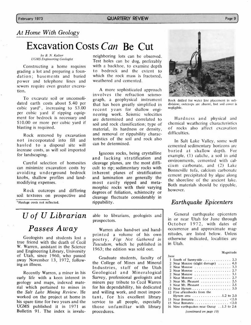
Excavation Costs Can Be Cut by B. N. Kaliser
UGMS Engineering Geologist
Constructing a home requires grading a lot and preparing a foundation; basements and buried power and telephone lines and sewers require even greater excavation.
To excavate soil or unconsolidated earth costs about $.40 per cubic yard', increasing to $3.00 per cubic yard if ripping equipment for bedrock is necessary and $10. 00 or more per cubic yard if blasting is required.
Rock removed by excavation not incorporated into fill and hauled to a disposal site will increase costs, as will soil imported for landscaping.
Careful selection of homesites can minimize excavation costs by avoiding underground bedrock knobs, shallow profiles and landmodifying expenses.
Rock outcrops and differing soil textures on prospective and 1 Haulage costs not reflected.
U of U Librarian
Passes Away Geologists and students lost a
true friend with the death of Cecil W. Warren, assistant in the Science and Engineering Library, University of Utah, since I 960, who passed away November 13, 1972, following an illness.
Recently Warren, a miner in his early life with a keen interest in geology and maps, indexed material which pertained to mines in the Salt Lake Mining Review. He worked on the project at home in his spare time for two years and the UGMS published it in 197 l as Bulletin 91. The index is invalu-
neighboring lots can be observed. Test holes can be dug, preferably with a backhoe, to examine depth to bedrock and the extent to which the rock mass is fractured, weathered and cemented.
A more sophisticated approach involves the refraction seismograph, a geophysical instrument that has been greatly simplified in recent years for shallow engineering work. Seismic velocities are determined and correlated to soil and rock classification; type of material, its hardness or density, and removal or rippability characteristics of the soil and rock also can be determined.
Igneous rocks, being crystalline and lacking stratification and cleavage planes, are the most difficult to rip; sedimentary rocks with inherent planes of stratification and lamination are generally the most easily ripped and metamorphic rocks with their varying degrees of foliation, schistocity or cleavage fluctuate considerably in rippability.
able to librarians, geologists and prospectors.
Warren also hand-set and handprinted a volume of his own poetry, Figs Not Gathered in Tusculum, which he published m I 963; the edition was sold out.
Graduate students, faculty of the College of Mines and Mineral Industries, staff of the Utah Geological and Mineralogical Survey, professional geologists and miners pay tribute to Cecil Warren for his dependability, his dedicated and willing work, and most important, for his excellent library service to all people, especially those unfamiliar with library procedures.
Page 9)
Rock drilled for water line placement in subdivision ; outcrops are absent, but soil cover is negligible.
Hardness and physical and chemical weathering characteristics of rocks also affect excavation difficulties.
In Salt Lake Valley, some well cemented sedimentary horizons are buried at shallow depth. For example, (I) caliche, a soil in arid environments, cemented with calcium carbonate, and (2) Lake Bonneville tufa, calcium carbonate cement precipitated by algae along the shoreline of the ancient lake. Both materials should be rippable, however.
Earthquake Epicenters
General earthquake epicenters in or near Utah for June through 0 ct ob er 1 9 7 2 , with dates of occurrence and approximate magnitudes, are listed below. Unless otherwise indicated , localities are in Utah.
Magnitude June
1 South of Sunnyside . .... . . . .. .. . 2.3 2 Near Monroe (slight damage) ... .. . 4 .0 2 Near Monroe .. .... . .. . .. . . . . . 3.3 2 Near Monroe . . . . . . . . . . . . . . . . . 2. 7 2 Near Monroe . . . . . . . . . . . . . . . . . 3. l 3 Near Monroe . . . . . ... ..... .... 2.7 3 Near Mt. Pleasant .. ... . . .... . .. 2.5 3 Near Mt. Pleasant . . . . . . . . . . . . . . 2.5
12 Near Hyrum .......... . ..... . . 3.0 12 Five aftershocks from the
Hyrum area ... .. . .. ... ... 1.2 to 2.0 15 Near Bonanza . . ........ .. .... < 2.0 15 Near Bonanza ... ...... . ...... < 2.0 16 Nine ea'rthqu akes near Ouray .. 1.3 to 2.6
(continued on page I 0)
(Page 10
(continued from page 9)
17 Near Bonanza . . . . . . . . . . . . . . . . . 1.6 19 South of Sunnyside ............ < 2.0 20 Near Bonanza ................ < 2.0 21 Near Bonanza .... ......... .... 2.1 24 Near Bonanza . . . . . . . . . . . . . . . . . 2.0 24 Near Bonanza . . . . . . . . . . . . . . . . . 2.0 29 Near Coalville . . . . . . . . . . . . . . . . . 1.9 30 South of Vernon ............ . . 2.2
July 1 Near Antimony . . . . . . . . . . . . . . . 2.4 1 San Rafael Swell . . . . . . . . . . . . . . . 2.4 2 East central Nevada . . . . . . . . . . . . . 2.5 2 East central Nevada ..... .. .... .. 3.0 2 South of Hatch . . . . . . . . . . . . . . . 3.0 3 South of Hatch ............... 2.5 4 South of Sunnyside ... . . ........ 2.6 6 South of Bonanza .. .... ........ 1.7 7 Near Fairview ... . ..... . .... ... 2.7
13 Near Marysvale . . . . . . . . . . . . . . . . 3.0 14 Promontory Point ........ . ..... 2.3 18 East of Bear Lake .. .. ... ... .... 3.5 19 Near Fayette ..... . .......... < 2.0 20 South end of Great Salt Lake ..... < 2.0 20 Near Lehi . . . . . . . . . . . . . . . . . . . 2.6 21 South of Ephraim . ............ . 2.6 22 North of Preston , Idaho .. .... .... 2.5 22 North of Oak City .. . . . . . ...... 2.2 26 East of Sigurd ............... < 2 .0 26 South Wyoming . ..... . .. . . .... 2.1 27 South of Levan ...... . ....... < 2.0 31 Near Manti ......... . .. ...... 2.2 31 East of Richfield ....... . ...... 2.5
August 1 Near Morgan . . . . . . . . . . . . . . . . . 1.6 5 Near Junction .... ... . ........ 2.6 6 North of Randolph ..... ... ..... 3.6 8 Near Spanish Fork ..... .. ...... 2.1
16 Near Redmond . ............ ... 2.1 16 Promontory Point . .. .. . .. . . ... < 2.0 16 North of Vernal .. .... ..... . .. < 2.0 17 Near Bear Lake . .... . . .. ... ... 2.5 17 Central Utah-Arizona border . . ... . . 2.5 22 South of Coalville . . . . . . . . . . . . . . 1. 7 26 Near Cedar City .............. < 2 .0
UTA H
G EOLOGICAL .\!'ID Ml:'\TERALOGIC:\L SURVEY
! OJ U TAH Gr.0Loc1CAL SuRvE.v Bu11.01No
THE UN IVERSITY OF UTAH SALT LAKE CIT\' , UTA H 84112
llddn ·.,·s correction requested
QUARTERLY REVIEW
26 Near Salina .................. 2.1 27 Near Big Piney, Colorado . . . . . . . . . 2.9 28 Near Coalville . . . . . . . . . . . . . . . . . 2.3 28 Near Cedar City .......... . ... <2.0 28 Near Scipio . . . . . . . . . . . . . . . . . . 2.0
September 1 South of Moore ..... ... . . . .... 2.0 2 South of Cedar City ............ 3.5 7 Near Castle Dale .. ......... ... <2.0
13 Near Helper . . . . . . . . . . . . . . . . . < 2 .0 13 South of Sunnyside ....... .. ... < 2.0 14 South of Bonanza . ..... . ...... < 2.0 15 South of Sunnyside . . ........... 2.2 15 Near Richmond . . . . . . . . . . . . . . . 2.9 15 Near Castle Gate . . . . . . . . . . . . . . . 1.9 16 South of Sunnyside .. . . ..... ... <2.0 19 North of Scipio ... ... ......... 2.2 21 Near Farmington Bay . . . . . . . . . . . 1.5 21 Near Farmington Bay ...... . .... 2.2 22 Near Farmington Bay . . . . . . . . . . . 1.5 23 San Rafael Swell ............ . . < 2.0 27 Near Strawberry Reservoir . . . . . . . . 2.3 27 South of Fillmore . . , . . .... .. .. . 2.5 28 Near Castle Dale ....... ..... ... 2.2
October 1 Near Richfield . . . . . . . . . . . . . . . . 2.6 1 Near Heber City (slight damage in
Heber City and Midway (approx. location 40° 51' N. lat. 111°35' W. long.) .............. 4.1
1 Near Heber City . . ............ . 3.8 1 Near Heber City . . . . . . . . . . . . . . . 2.8 1 Near Heber City . . . . . . . . . . . . . . . 3.1 2 Near Heber City . . . . . . . . . . . . . . . 3.2
1-13 Ninety small aftershocks near Heber City ........ .... .. < 2.5
8 Near Price . . .......... . ..... < 2.0 13 South of Sunnyside .... .. . . .... < 2.0 14 Near Strawberry Reservoir ....... < 2.0 15 Near Heber City . . . . . . . . . . . . . . . 1.4 16 Near Hanna (approx. location 40° 41'
N. lat. 111°01' W. long.) . .. . ..... 3.0 17 Near Hanna . . . . . . . . . . . . . . . . . . 2.4 17 Kaiparowits Plateau ............. 3.2
February 1973)
19 Utah-Nevada border west of Palute, Utah . . . . . . . . . . . . . . . . . . 2.9
21 South of Kamas .. . . . ... ....... 2.1 29 South of Sunnyside ............ < 2.0 29 Utah-Arizona border south of
St. George . . ..... . .. ........ . 3.2 29 Utah-Arizona border south of
St. George ....... ... . ..... . .. 3.0 30 Near Cedar City .. ............ < 2.0 30 Fifteen miles northwest of
Strawberry Reservoir . . . . . . . . . . . . 1.9 30 Fifteen miles northwest of
Strawberry Reservoir ... . ........ 1.4 31 Near Heber City ....... ... . ... . 1.6
These earthquakes were recorded by the University of Utah seismograph stations under the direction of Kenneth L. Cook. All locations and magnitudes are preliminary determinations; the fin a 1 de term in at i o n s w i 11 be printed in the University of Utah Seismological Bulletin, issued quarterly.
QUARTERLY RFVl [W State of ll tah
Universit y nf Utah
. . C a/1' 111 / .. Rampton (,'n1·1·nw r
.. -1/frcd C hn,n· l'r n 1J<' 11t
College nf Mines & Mineral Industries .... Alex C. Oblad
Acting Dean Utah Ceolog,cal & Mincralo!!iL·al
Survey . William I'. 1/ew ilf I >irectnr
UTAH GEOLOGIC AL AND MINERALOGI CAL SURVEY
I 03 Utah Cenlogi u 1l Survey Building Uni vern ty o f Uta h
Sa lt Lake City. Utah 84 112
Nonprofit Org. U. S. Postage Paid Permit No. 15 29
Salt Lake City, Utah