Embed Size (px)
Citation preview

Utah History MapsUtah History Maps
By Christin Figgins
Trails and Boundaries of Trails and Boundaries of Deseret MappingDeseret Mapping
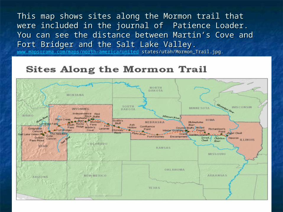
This map shows sites along the Mormon trail that were This map shows sites along the Mormon trail that were included in the journal of Patience Loader. You can see the included in the journal of Patience Loader. You can see the distance between Martindistance between Martin’’s Cove and Fort Bridger and the Salt s Cove and Fort Bridger and the Salt Lake Valley.Lake Valley.www.mapsorama.com/maps/north-america/united states/utah/Mormon_Trail.jpg. states/utah/Mormon_Trail.jpg.
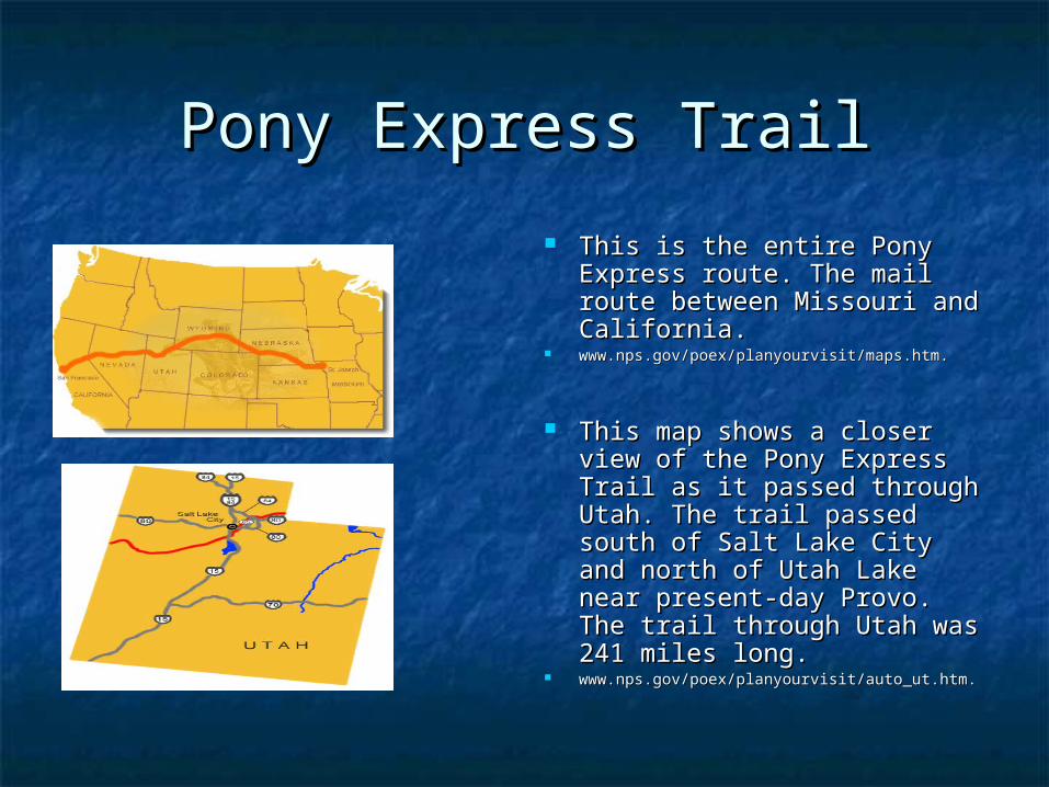
Pony Express TrailPony Express Trail
This is the entire Pony This is the entire Pony Express route. The mail Express route. The mail route between Missouri and route between Missouri and California. California.
www.nps.gov/poex/planyourvisit/maps.htm.www.nps.gov/poex/planyourvisit/maps.htm.
This map shows a closer This map shows a closer view of the Pony Express view of the Pony Express Trail as it passed through Trail as it passed through Utah. The trail passed south Utah. The trail passed south of Salt Lake City and north of Salt Lake City and north of Utah Lake near present-of Utah Lake near present-day Provo. The trail through day Provo. The trail through Utah was 241 miles long.Utah was 241 miles long.
www.nps.gov/poex/planyourvisit/auto_ut.htm.www.nps.gov/poex/planyourvisit/auto_ut.htm.

The Old Spanish TrailThe Old Spanish Trail
www.oldspanishtrail.org/learn/maps.phpwww.oldspanishtrail.org/learn/maps.php
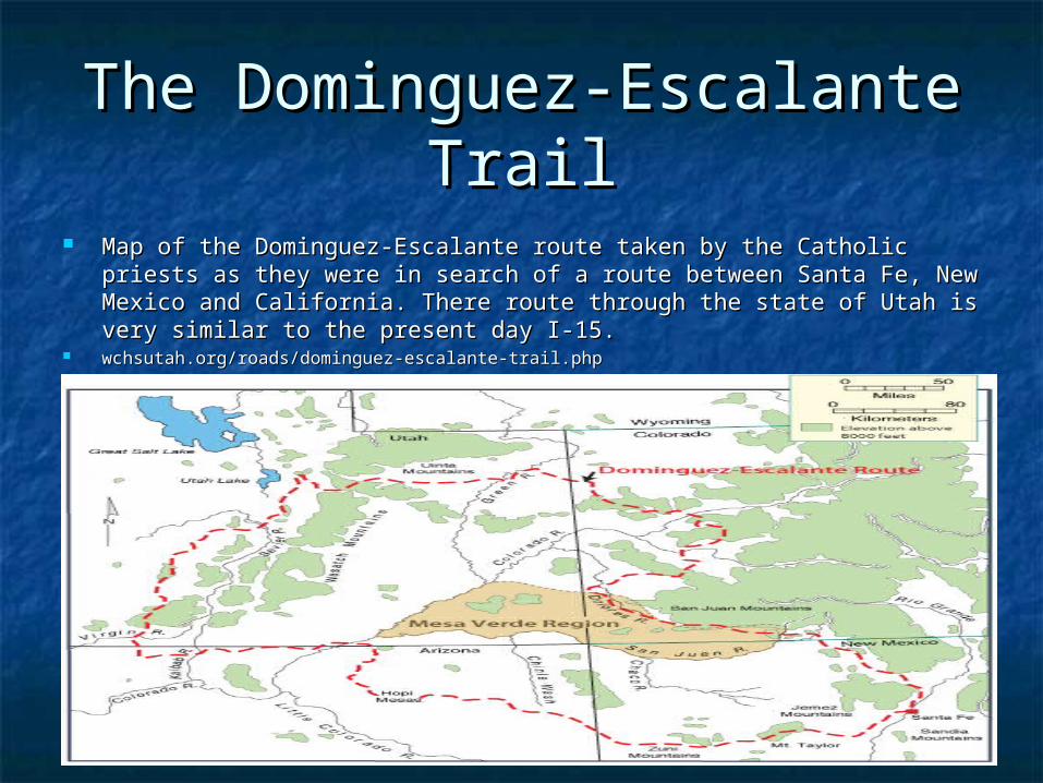
The Dominguez-Escalante The Dominguez-Escalante TrailTrail
Map of the Dominguez-Escalante route taken by the Catholic priests as Map of the Dominguez-Escalante route taken by the Catholic priests as they were in search of a route between Santa Fe, New Mexico and they were in search of a route between Santa Fe, New Mexico and California. There route through the state of Utah is very similar to the California. There route through the state of Utah is very similar to the present day I-15.present day I-15.
wchsutah.org/roads/dominguez-escalante-trail.phpwchsutah.org/roads/dominguez-escalante-trail.php
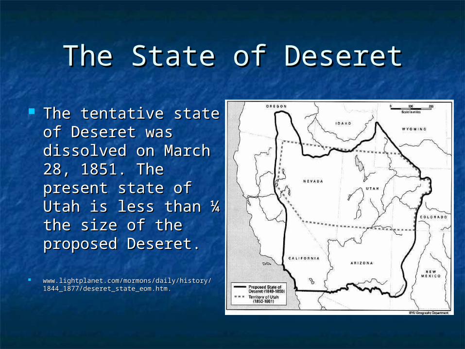
The State of DeseretThe State of Deseret
The tentative state The tentative state of Deseret was of Deseret was dissolved on March dissolved on March 28, 1851. The 28, 1851. The present state of present state of Utah is less than ¼ Utah is less than ¼ the size of the the size of the proposed Deseret.proposed Deseret.
www.lightplanet.com/mormons/daily/history/www.lightplanet.com/mormons/daily/history/1844_1877/deseret_state_eom.htm.1844_1877/deseret_state_eom.htm.

•Historic Locations Maps

Mountain MeadowsMountain Meadows This map shows where the massacre occurred in comparison to the cities This map shows where the massacre occurred in comparison to the cities
of Cedar City and St. George.of Cedar City and St. George. Law2.umkc.edu/faculty/projects/ftrials/mountainmeadows/mmmmap2.jpgLaw2.umkc.edu/faculty/projects/ftrials/mountainmeadows/mmmmap2.jpg

Cove FortCove Fort Located approximately 71 miles north of Cedar City.Located approximately 71 miles north of Cedar City. www.covefort.com/map.htmwww.covefort.com/map.htm

Camp FloydCamp Floyd Camp Floyd, located just west of the present city of Lehi and near Camp Floyd, located just west of the present city of Lehi and near
the town of Fairfield, was the first military post built in the state of the town of Fairfield, was the first military post built in the state of Utah. It was built in 1858 to house federal soldiers sent to Utah Utah. It was built in 1858 to house federal soldiers sent to Utah during the during the ““Mormon WarMormon War””..
www.nps.gov/poex/planyourvisit/site7.htm.www.nps.gov/poex/planyourvisit/site7.htm.
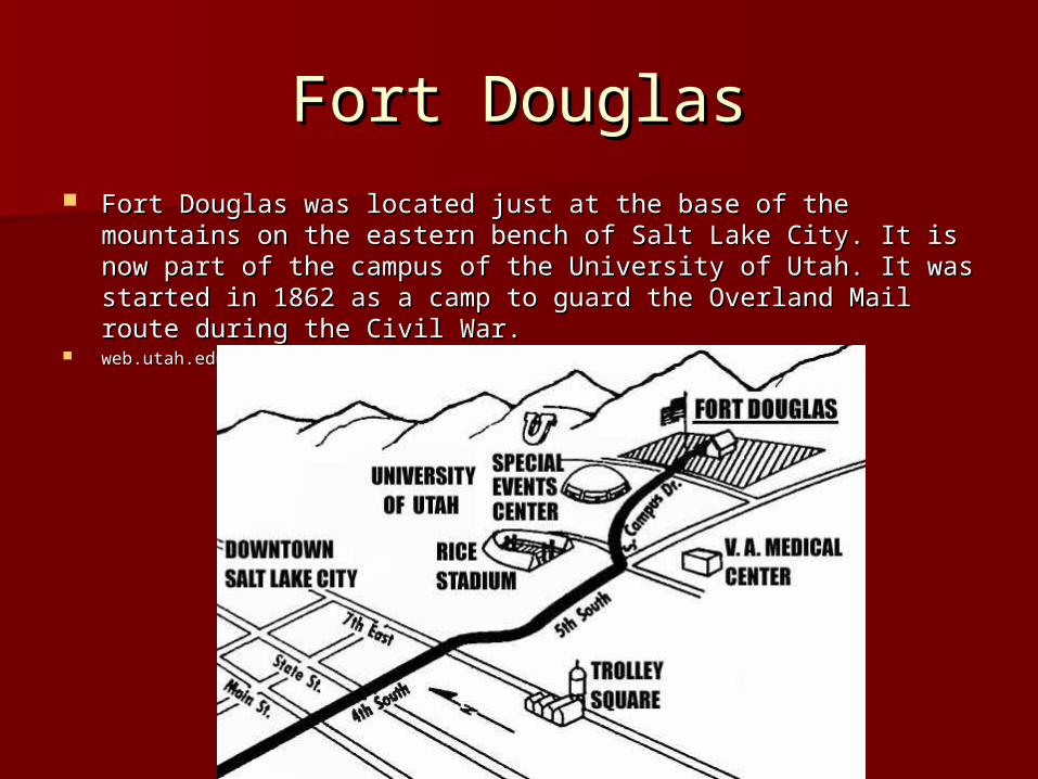
Fort DouglasFort Douglas Fort Douglas was located just at the base of the mountains on the Fort Douglas was located just at the base of the mountains on the
eastern bench of Salt Lake City. It is now part of the campus of the eastern bench of Salt Lake City. It is now part of the campus of the University of Utah. It was started in 1862 as a camp to guard the University of Utah. It was started in 1862 as a camp to guard the Overland Mail route during the Civil War.Overland Mail route during the Civil War.
web.utah.edu/facilities/fd/welcome/location_map.htmlweb.utah.edu/facilities/fd/welcome/location_map.html
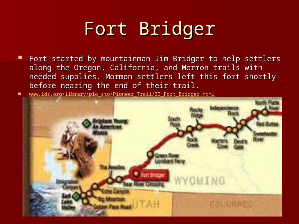
Fort BridgerFort Bridger Fort started by mountainman Jim Bridger to help settlers along the Fort started by mountainman Jim Bridger to help settlers along the
Oregon, California, and Mormon trails with needed supplies. Oregon, California, and Mormon trails with needed supplies. Mormon settlers left this fort shortly before nearing the end of Mormon settlers left this fort shortly before nearing the end of their trail.their trail.
www.lds.org/library/pio_sto/Pioneer_Trail/33_Fort_Bridger.html
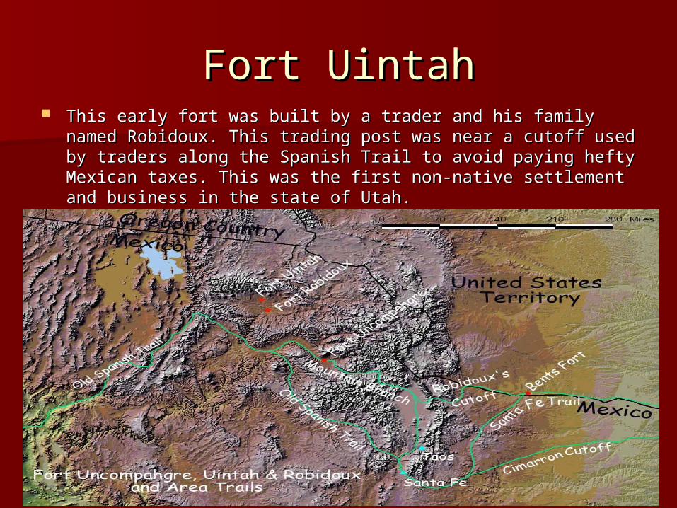
Fort UintahFort Uintah This early fort was built by a trader and his family named This early fort was built by a trader and his family named
Robidoux. This trading post was near a cutoff used by traders Robidoux. This trading post was near a cutoff used by traders along the Spanish Trail to avoid paying hefty Mexican taxes. This along the Spanish Trail to avoid paying hefty Mexican taxes. This was the first non-native settlement and business in the state of was the first non-native settlement and business in the state of Utah.Utah.
www.nman.us/FortUncompahgreMap.htm.www.nman.us/FortUncompahgreMap.htm.
• Physiographic Locations

Mountain Ranges in UtahMountain Ranges in Utah(Uintah, Wasatch, and Oquirrh)(Uintah, Wasatch, and Oquirrh)
Geology.utah.gov/surveynotes/gladasked/gladglaciers.htm.Geology.utah.gov/surveynotes/gladasked/gladglaciers.htm.
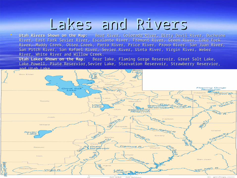
Lakes and RiversLakes and Rivers Utah Rivers Shown on the Map:Utah Rivers Shown on the Map: Bear River, Colorado River, Dirty Devil River, Duchesne River, East Fork Sevier Bear River, Colorado River, Dirty Devil River, Duchesne River, East Fork Sevier
River, Escalante River, Fremont River, Green River, Lake Fork River, Muddy Creek, Otter Creek, Paria River, Price River, Escalante River, Fremont River, Green River, Lake Fork River, Muddy Creek, Otter Creek, Paria River, Price River, Provo River, San Juan River, San Pitch River, San Rafael River, Sevier River, Uinta River, Virgin River, Weber River, Provo River, San Juan River, San Pitch River, San Rafael River, Sevier River, Uinta River, Virgin River, Weber River, White River and Willow Creek. River, White River and Willow Creek. Utah Lakes Shown on the Map:Utah Lakes Shown on the Map: Bear lake, Flaming Gorge Reservoir, Great Salt Lake, Lake Powell, Piute Bear lake, Flaming Gorge Reservoir, Great Salt Lake, Lake Powell, Piute Reservior,Sevier Lake, Starvation Reservoir, Strawberry Reservior, and Utah Lake.Reservior,Sevier Lake, Starvation Reservoir, Strawberry Reservior, and Utah Lake.
geology.com/lakes-rivers-water/utah.shmtl.geology.com/lakes-rivers-water/utah.shmtl.
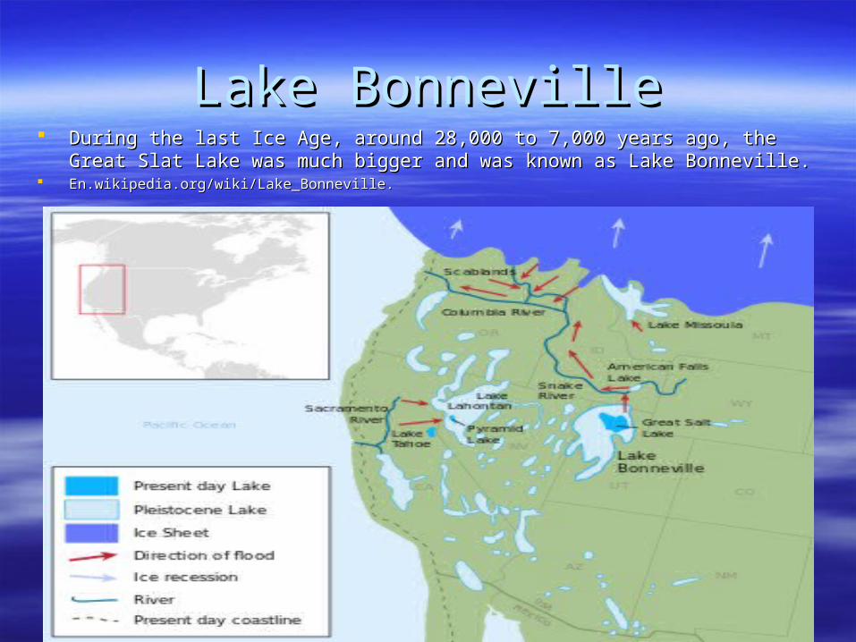
Lake BonnevilleLake Bonneville During the last Ice Age, around 28,000 to 7,000 years ago, the Great Slat Lake was During the last Ice Age, around 28,000 to 7,000 years ago, the Great Slat Lake was
much bigger and was known as Lake Bonneville.much bigger and was known as Lake Bonneville. En.wikipedia.org/wiki/Lake_Bonneville.En.wikipedia.org/wiki/Lake_Bonneville.
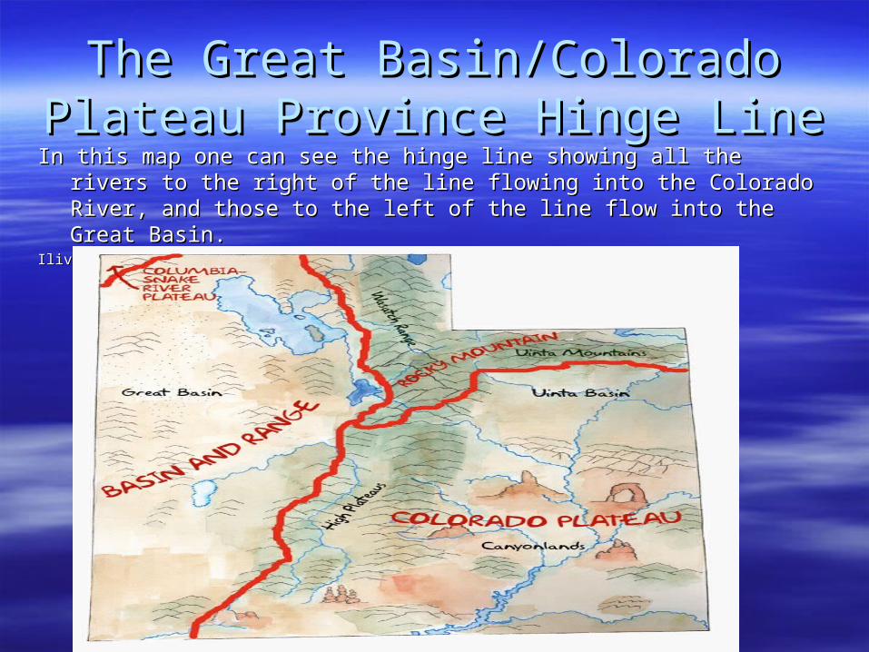
The Great Basin/Colorado Plateau The Great Basin/Colorado Plateau Province Hinge LineProvince Hinge Line
In this map one can see the hinge line showing all the rivers to the right of the line In this map one can see the hinge line showing all the rivers to the right of the line flowing into the Colorado River, and those to the left of the line flow into the flowing into the Colorado River, and those to the left of the line flow into the Great Basin.Great Basin.
Ilivehistory.utah.gov/place/land/maps/provinces.html#map.Ilivehistory.utah.gov/place/land/maps/provinces.html#map.

Valleys in UtahValleys in Utahilovehistory.utah.gov/place/land/maps/provinces.html#map
Cache ValleyCache Valley
Salt Lake Valley
Utah Valley Ashley Valley
San Pete Valley
Sevier Valley
Cache Valley
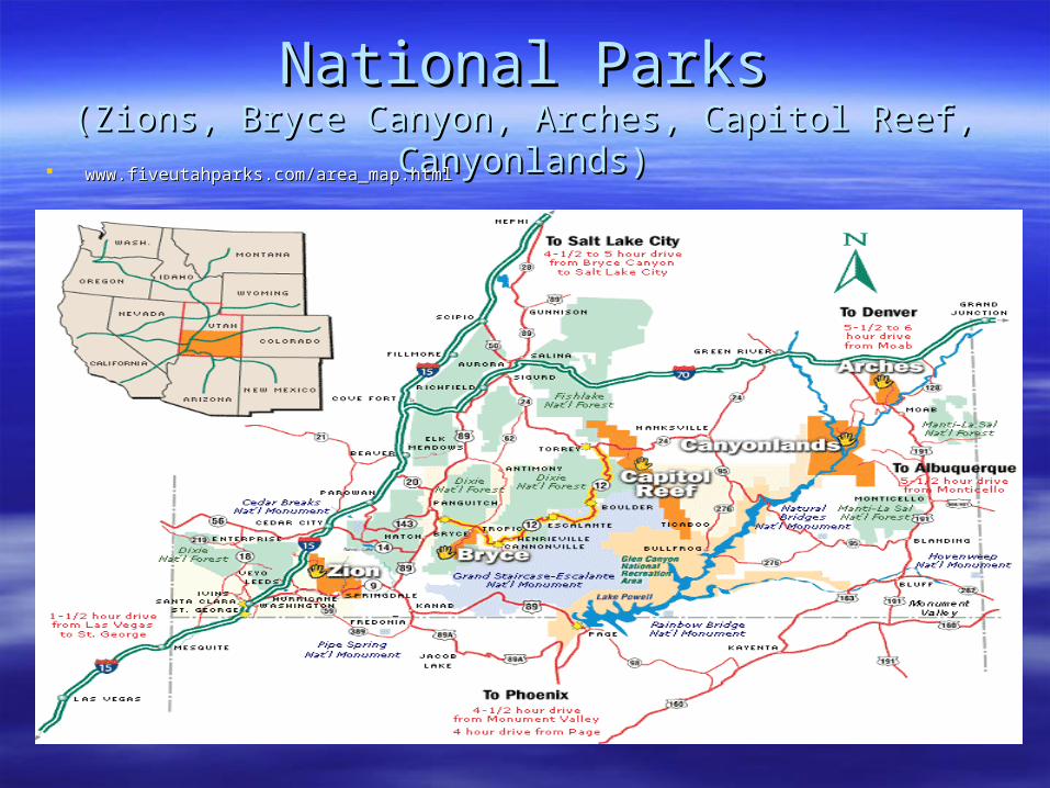
National ParksNational Parks(Zions, Bryce Canyon, Arches, Capitol Reef, Canyonlands)(Zions, Bryce Canyon, Arches, Capitol Reef, Canyonlands)
www.fiveutahparks.com/area_map.htmlwww.fiveutahparks.com/area_map.html