Embed Size (px)
Citation preview

Vancouver Island Region
for Woss Lake Provincial Park
ANAGEMENT D IRECTION S TATEMENT
Ministry of Water, Land andAir Protection Environmental Stewardship Division
September 2003
M

1
Woss Lake Provincial Park Approvals Page
Forward This management direction statement for Woss Lake Provincial Park provides management direction for the foreseeable future.
Approvals:

1
Table of Contents page
Introduction 1
Purpose of the Management Direction Statement ....................................................................2 Context ..................................................................................................................................2 Conservation......................................................................................................................... 5 Cultural Heritage ....................................................................................................................5 Recreation and Tourism..........................................................................................................6 Significance in the Protected Areas System .............................................................................6
Land Uses, Activities and Interests 7
Access...................................................................................................................................7 Existing Tenures, Alienations and Encumbrances .................................................................... 7 Existing Land Use Activities and Facilities .............................................................................. 7 Adjacent Patterns of Land Use .............................................................................................. 7 First Nations Interests ........................................................................................................... 7 Other Agency Interests.......................................................................................................... 8 Private and Public Stakeholder Interests ................................................................................ 8
Role of the Park 8
Management Commitments and Issues 9
Management Direction from Previous Planning ....................................................................... 9 Management Issues ............................................................................................................... 9
Management Direction 11
Priority Management Objectives and Strategies..................................................................... 11 Consultation and Future Planning ......................................................................................... 12 Zoning Plan......................................................................................................................... 13
Wilderness Recreation Zone 13 Natural Environment Zone 13 Special Feature Zone 13
Appendix A ........................................................................................................................ 15
Table of Figures
Figure 1: Regional Context Map ........................................................................................... 3 Figure 2: Park Map .............................................................................................................. 4 Figure 3: Zoning Plan.......................................................................................................... 14

2
Introduction
Purpose of the Management Direction Statement Management direction statements provide strategic management direction for all protected areas that do not have an approved management plan, but do not negate the need for more detailed management plans in the future. Management direction statements include protected area values; management issues and concerns; and priority management objectives and strategies. The implementation and completion of all these strategies to resolve management issues is subject to available funding. In addition, all development associated with these strategies is subject to BC Parks Impact Assessment Policy within protected areas.
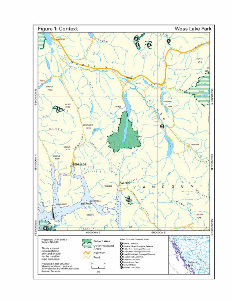
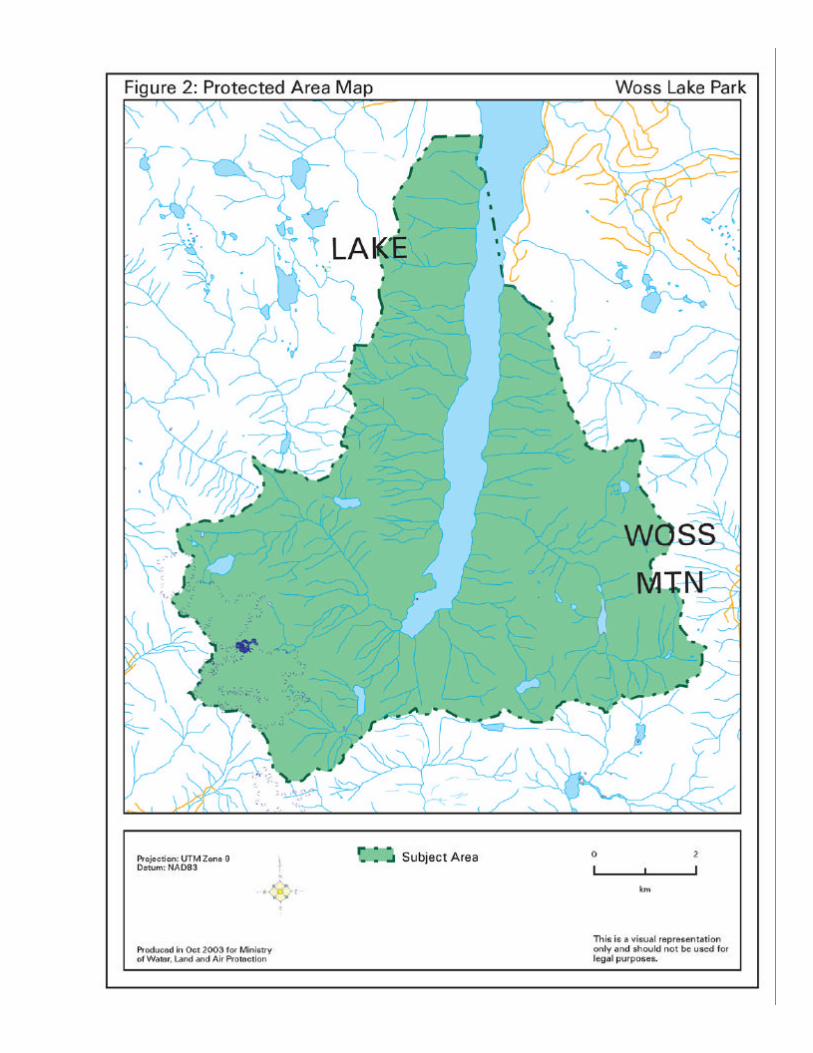
Context Woss Lake Provincial Park is 6,634 hectares and is located on north-central Vancouver Island, at the head of Woss Lake, immediately south of Woss. The park is approximately 140 km northwest on the island highway from Campbell River. The protection of Woss Lake addresses Goal 1 of the Protected Areas Strategy by conserving viable representative examples of old growth forest, lake and mountain ecosystems in the Northern Island Mountains Ecosection (NIM). The park contributes land in the Coastal Western Hemlock (CWH) Biogeoclimatic sub-zones vm1, vm2, xm2, all of which are under-represented (<8%) in the Protected Areas System. Woss Lake Park also addresses Goal 2 of the Protected Area Strategy by protecting special old-growth forest features, an alpine glacier, archeological sites, salmon-spawning watershed, sensitive delta, and rare plants, and by offering outstanding outdoor wilderness recreation and the potential for extensive First Nations cultural and heritage interpretation opportunities. Woss Lake Park was recommended for protection by the Commission on Resources and the Environment (CORE), and by the Vancouver Island Land Use Plan. The area was designated Class A Provincial Park on July 12, 1995. The park is within the traditional territory of the ‘Namgis First Nation which has a long and diverse history associated with the area in and around Woss Lake Park, one that includes guiding the first forestry explorers in 1896. The ‘Namgis First Nation has asserted its Aboriginal rights and title to Woss Lake Park, and has identified it as an area of interest in its negotiation of a treaty under the British Columbia Treaty Commission process.

5
Protected Area Attributes
Conservation • Protects a representative example of a temperate rainforest environment that is greater than 5,000
hectares in size located in the under-represented Northern Island Mountains Ecosection (NIM). At 11%, it is the third largest contributor to the representation of NIM out of 18 other protected areas located in this ecosection. The park makes a minimal contribution (less than 1%) to the representation of Windward Island Mountains Ecosection (WIM) which is well-protected in the protected areas system.
• Contributes to three under-represented variants of the Coastal Western Hemlock (CWH) biogeoclimatic zone. They include CWH xm2, vm2, and vm1. It is the fourth largest contributor of 30 protected areas to the representation of CWHvm2; it contributes 4.2% to the representation of this variant that has only 4.1% protected. The park also contributes to representation of Mountain Hemlock which is well-represented at 16%.
• Protects a viable representative example of old-growth forest habitat. Most of the upland portion of the park is covered with mature forest more than 360 years old in a region where old growth forests have become rare due to extensive forest development.
• Protects important anadromus fish habitat in an unnamed creek with spawning chinook salmon (Oncorhynchus tshawytscha), and steelhead (Oncorhynchus gairdneri). The streams in Woss Lake Park also provide habitat for resident populations of rainbow trout and blue listed cutthroat trout and Dolly Varden
• Protects blue listed plants - lance-fruited draba (Draba lonchocarpa car vestige), wedge-leaf primrose (Primula cuneifolice ssp saxifragifolia) and yellow-listed species for conservation concern (S3-S4) - caltha-leaved avens (Geum calthifolium), alp lily (Lloydia serotina) and western St. John-wort (Hypericum scouleri var scouleri)
• Includes high potential habitat to red listed Vancouver Island wolverine, Vancouver Island marmot and blue listed Roosevelt elk
• Contains largest alpine glacier on Vancouver Island , Rugged Mountain, stream with glacial silt (unusual for Vancouver Island), sensitive river delta
Cultural Heritage • Contains part of an ancient trail system that includes a ‘grease’ trail crossing from the southern end
of Woss Lake to the West Coast (Tahsis Inlet) which was used for trade and commerce between the ‘Namgis and Mowachaht / Muchalaht First Nations. The Grease Trail is one part of a broad cultural-tourism initiative that is being developed by the ‘Namgis First Nation.
• Protects the site of several ancient ‘origin’ stories that connect the emergence of some of the ‘Namgis ‘houses’ or clans to the present day
• Protects a large number of pictographs, arborglyphs and other culturally modified trees (CMTs) • Contains several ancient village, sacred and ceremonial sites • Includes numerous hunting, fishing, trapping, and traditional food and medicinal plant harvesting
areas

6
Recreation and Tourism • Offers a variety of wilderness recreation opportunities including backcountry hiking, camping,
fishing, skiing and mountaineering on Rugged Mountain. Mountaineering history includes first attempt, by Europeans, to climb Rugged Mountain (referred to as Ben Lomond) in 1852 by Hamilton Moffat of Hudson Bay Company. First successful ascent was in 1959, by local climbers George Lepore and Robert Bissed.
• Provides recreational angling on Woss Lake • Features opportunities for ‘Namgis First Nation to develop interpretive cultural tours for park and
surrounding area • Includes spectacular mountain scenery, including the largest glacier on Vancouver Island providing
superb opportunities for photography and nature appreciation
Significance in the Protected Areas System • Contributes to the under-represented CWHvm1 (7%), vm2 (8.7%) and xm2 (4.1%)variants in the
Northern Island Mountains • Protects important anadromous fish habitat, and contributes spawning habitat for resident fish
populations in Woss Lake • Protects rare plant and animal species in old-growth forest • Protects significant First Nation values

7
Land Uses, Activities and Interests
Access • Can be accessed directly by air or boat, or by logging roads outside the park. Unpaved road leads
to access point on eastern shore of Woss Lake at the northern edge of the park. • Mountaineers approach peaks and glaciers of Rugged Mountain from south using Zeballos Road to
Nomash River Valley
Existing Tenures, Alienations and Encumbrances • Trapping license • Guide outfitter territory
Existing Land Use Activities and Facilities • Recreational fishing and hunting • Adjacent Canadian Forest Products (Canfor) campsite with 24 sites, dock, and boat launch. • Mountain climbing • Heli-skiing and snow-boarding on Rugged Mountain • No built-in facilities
Adjacent Patterns of Land Use • Surrounded by Tree Farm License 37 operated by Canadian Forest Products (Canfor) • Grease trail within park boundary part of larger trail system used for over land transport by First
Nations • ‘Namgis structure erected near park boundary in 2002 to support traditional gatherings • Logging road along east side of Woss Lake reaches northeastern border of park and ends at
campsite
First Nations Interests • Within the traditional territory of the ’Namgis First Nation, and subject of negotiations in BC Treaty
Process • Extensive current and traditional use in park and throughout Woss Lake region including significant
trade/commerce and transportation routes, hunting, trapping and fishing, food, medicinal plant gathering, and traditional resource harvesting
• Identification and protection of cultural and heritage sites - ‘Namgis First Nation is considering a permitting system in some areas of park to minimize impacts on cultural and heritage sites
• Identification and protection of cultural heritage features including petroglyphs, arborglyphs and other culturally-modified trees
• Identification and protection of spawning beaches • Identification and protection of, and access to, sacred and ceremonial sites within park
8
• Opportunities to develop cultural-tourism initiatives relating to grease trail and other cultural and heritage sites and activities
• Ability to develop traditional structure(s) within park boundary • Continued access to important food and resource harvesting areas • Pursuing management of the park
Other Agency Interests • Fisheries and Oceans Canada (DFO) - anadromous fish habitat and populations • Ministry of Water, Land and Air Protection, Fish and Wildlife Science and Allocation Section - fish
and wildlife populations and habitat, biodiversity objectives, administration of traplines and guide outfitting tenures
• Ministry of Sustainable Resource Management, Archeology Branch - historic aboriginal sites • Mt. Waddington Regional District - planning issues
Private and Public Stakeholder Interests • Gwa’ni fish hatchery
• Local communities - Woss, Zeballos • Guide outfitters • Trappers • Canadian Forest Products • Environmental groups concerned about protected area management
Role of the Park The primary role of Woss Lake Park is to protect an outstanding example of northern Vancouver Island’s mountain environment. With 6,634 hectares, the park protects part of Woss Lake and pristine old growth forested slopes above Woss Lake and an alpine wilderness area focused on the dominant feature of the area, Rugged Mountain. The scenery offered by this mountain and its glaciers, the largest on Vancouver Island, are of provincial significance. The natural ecosystems of the park support numerous wildlife species, including some that are endemic only to Vancouver Island. The park contains a nameless, intact secondary watershed of 1,600 hectares that drains from Rugged Mountain into the head of Woss Lake. This unnamed drainage was once proposed for ecological reserve designation and contains rare plants, avalanche track plant communities, and Coastal Western Hemlock plant communities, as well as valuable chinook salmon and steelhead spawning habitat and a sensitive river delta. The creek has a striking blue-green colour caused by glacial silt loading which is an unusual occurrence on Vancouver Island. Woss Lake Park protects a representative example of a temperate rainforest environment that is greater than 5,000 hectares in size located in the under-represented Northern Island Mountains (NIM) ecosection. The park also contributes to three under-represented variants of the Coastal Western Hemlock (CHW) biogeoclimatic zone, and a well-represented variant of the Mountain Hemlock (MH)

9
zone. Adding to the conservation value of these representative ecosystems, Woss Lake Park has most of its upland portion covered with mature forest more than 360 years old and the park is located in a region where old growth forests have become rare due to extensive forestry development. The secondary role is to protect cultural features. The park is the site of several ancient ‘origin’ stories of the ‘Namgis First Nation. It protects a number of village, sacred and ceremonial sites as well as pictographs, arborglyphs and other culturally modified trees. A heritage trade route and Grease Trail cross from the southern of the lake to the west coast of the island. The park has also long mountaineering history with the first European attempt to Rugged Mountain dating back to 1852. The tertiary role is to provide outstanding backcountry mountaineering opportunities in a roadless wilderness setting, a rare opportunity in a protected area on Vancouver Island. The park contains a variety of outdoor recreation features set in a scenic lake and rugged mountain context. There are no recreation facilities in the park but visitors with a boat, canoe, or kayak can enjoy various forms of recreation ranging from rugged backcountry hiking, camping and fishing, to aboriginal culture, nature, and scenery appreciation. Rugged Mountain, which is accessed by air or by way of logging roads outside the park, provides challenging backpacking, mountaineering and heli-dependent winter recreation opportunities. Outside the park boundary, a Canfor campsite on the northeast shore of Woss Lake that has a dock, boat launch and 24 campsites complements the recreational experience of Woss Lake Park.
Management Commitments and Issues
Management Direction from Previous Planning In June 1994, the Vancouver Island Land Use Plan recommended a protected area that included he southern end of Woss Lake to the height of land and the Clint Creek watershed. This recognized the area’s significant contribution of the representation of ecological variants.
A final technical review of the boundaries by the Protected Areas Boundary Adjustment Team (PABAT) excluded private land on the northern periphery and logged and roaded lands in the Clint Creek watershed. The remaining protected area continues to protect a large representative sample of the Northern Island Mountains Ecosection and under-represented biogeoclimatic variants, a heritage trade route, and wilderness recreation opportunities.
Management Issues
Theme Issue
Protecting cultural values • Increasing tourist and recreation use and lack of knowledge
and appreciation of First Nation’s cultural heritage may result in removal or destruction of cultural features and artifacts.
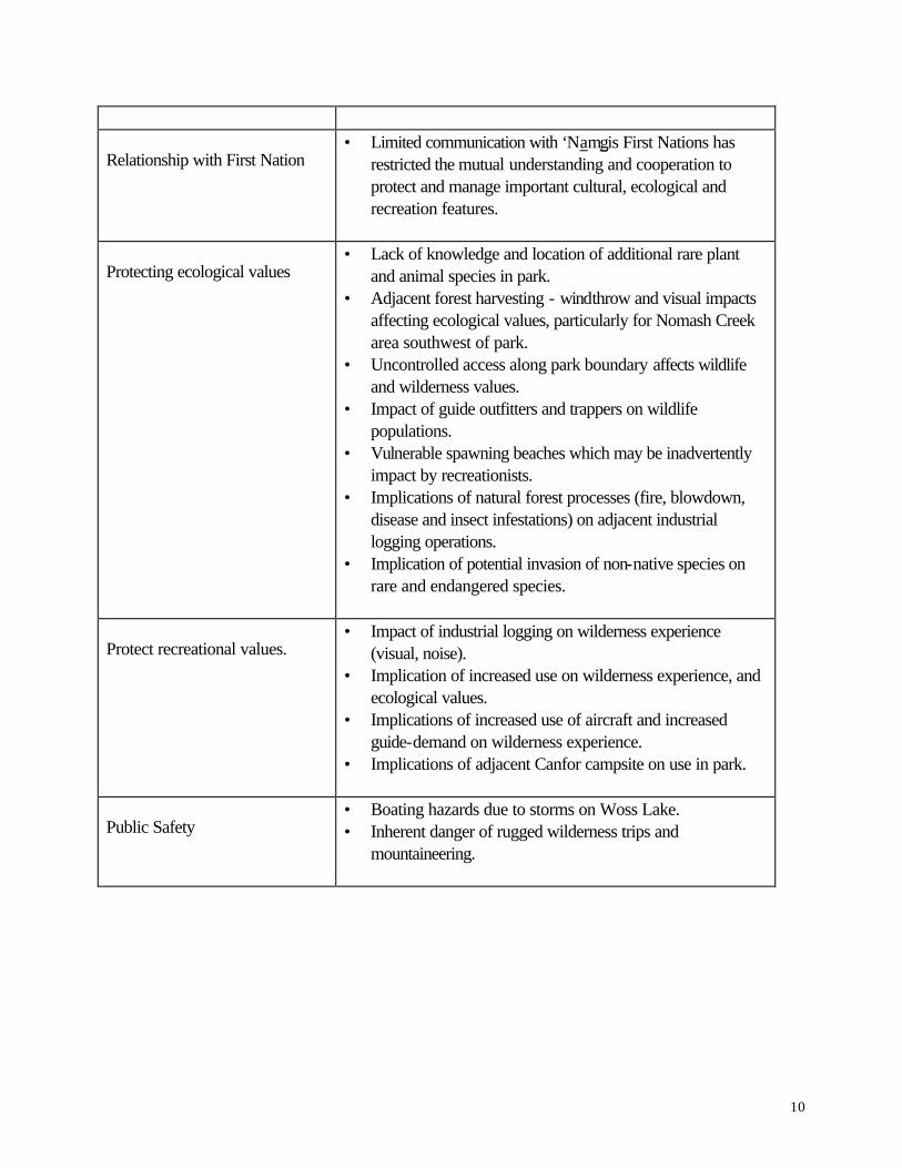
10
Relationship with First Nation • Limited communication with ‘Namgis First Nations has
restricted the mutual understanding and cooperation to protect and manage important cultural, ecological and recreation features.
Protecting ecological values • Lack of knowledge and location of additional rare plant
and animal species in park. • Adjacent forest harvesting - windthrow and visual impacts
affecting ecological values, particularly for Nomash Creek area southwest of park.
• Uncontrolled access along park boundary affects wildlife and wilderness values.
• Impact of guide outfitters and trappers on wildlife populations.
• Vulnerable spawning beaches which may be inadvertently impact by recreationists.
• Implications of natural forest processes (fire, blowdown, disease and insect infestations) on adjacent industrial logging operations.
• Implication of potential invasion of non-native species on rare and endangered species.
Protect recreational values.
• Impact of industrial logging on wilderness experience (visual, noise).
• Implication of increased use on wilderness experience, and ecological values.
• Implications of increased use of aircraft and increased guide-demand on wilderness experience.
• Implications of adjacent Canfor campsite on use in park.
Public Safety • Boating hazards due to storms on Woss Lake. • Inherent danger of rugged wilderness trips and
mountaineering.
11
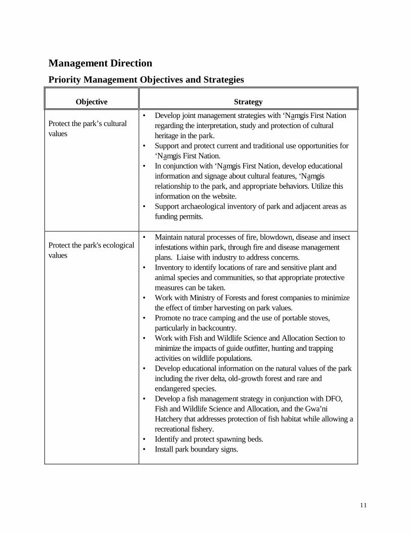
Management Direction
Priority Management Objectives and Strategies
Objective Strategy
Protect the park’s cultural values
• Develop joint management strategies with ‘Namgis First Nation regarding the interpretation, study and protection of cultural heritage in the park.
• Support and protect current and traditional use opportunities for ‘Namgis First Nation.
• In conjunction with ‘Namgis First Nation, develop educational information and signage about cultural features, ‘Namgis relationship to the park, and appropriate behaviors. Utilize this information on the website.
• Support archaeological inventory of park and adjacent areas as funding permits.
Protect the park's ecological values
• Maintain natural processes of fire, blowdown, disease and insect infestations within park, through fire and disease management plans. Liaise with industry to address concerns.
• Inventory to identify locations of rare and sensitive plant and animal species and communities, so that appropriate protective measures can be taken.
• Work with Ministry of Forests and forest companies to minimize the effect of timber harvesting on park values.
• Promote no trace camping and the use of portable stoves, particularly in backcountry.
• Work with Fish and Wildlife Science and Allocation Section to minimize the impacts of guide outfitter, hunting and trapping activities on wildlife populations.
• Develop educational information on the natural values of the park including the river delta, old-growth forest and rare and endangered species.
• Develop a fish management strategy in conjunction with DFO, Fish and Wildlife Science and Allocation, and the Gwa’ni Hatchery that addresses protection of fish habitat while allowing a recreational fishery.
• Identify and protect spawning beds. • Install park boundary signs.

12
Protect recreational values
• Monitor fishing pressure on the lake. • Develop education information and signage to ensure compliance
with DFO and WLAP fisheries regulations, restrictions and closures, e.g. for salmon and trout.
• Work with MOF and forest companies to address visual impacts, access and noise associated with timber harvesting, particularly along the lake approach to park.
• Work with ‘Namgis to explore the development of a small rustic campsite on the debris fan on the west side of the lake.
• Work with commercial aircraft operators to limit the impact of overflights and landings on the wilderness experience.
• Upgrade heritage trade route (Grease Trail) at south end of Woss Lake in conjunction with ‘Namgis First Nation. Develop two shelters to support cultural research and tourism.
• Monitor impacts of recreation use. Consider limiting use or issuing permits to ensure protection of cultural and wilderness experiences for all users.
Build a strong relationship with First Nations
• Work with ‘Namgis First Nation to identify interests for park management and for treaty.
• Work closely with the ‘Namgis First Nation in the development of a management plan when that occurs.
• Meet with ‘Namgis on a regular basis to keep them apprised of park management, seek advise, assist in cultural heritage initiatives, and increase cultural awareness and appreciation..
• Support ‘Namgis efforts to develop cultural tourism opportunities in park.
Ensure public safety • Alert boaters of potential sudden storms and lack of protected
moorage along Woss Lake shoreline within park through educational information posted on website.
• Alert wilderness travelers and mountaineers of inherent hazards through information posted on website.
Consultation and Future Planning • Development of a Management Plan to further define acceptable uses, use levels and zoning and
ensure the integrity of important habitats and species with public, industry and agency input. • Management Plan is a moderate priority for this park.
13
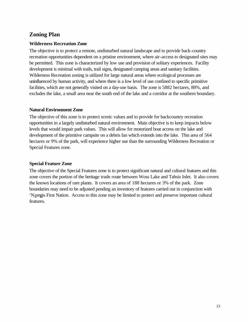
Zoning Plan
Wilderness Recreation Zone The objective is to protect a remote, undisturbed natural landscape and to provide back-country recreation opportunities dependent on a pristine environment, where air-access to designated sites may be permitted. This zone is characterized by low use and provision of solitary experiences. Facility development is minimal with trails, trail signs, designated camping areas and sanitary facilities. Wilderness Recreation zoning is utilized for large natural areas where ecological processes are uninfluenced by human activity, and where there is a low level of use confined to specific primitive facilities, which are not generally visited on a day-use basis. The zone is 5882 hectares, 88%, and excludes the lake, a small area near the south end of the lake and a corridor at the southern boundary.
Natural Environment Zone The objective of this zone is to protect scenic values and to provide for backcountry recreation opportunities in a largely undisturbed natural environment. Main objective is to keep impacts below levels that would impair park values. This will allow for motorized boat access on the lake and development of the primitive campsite on a debris fan which extends into the lake. This area of 564 hectares or 9% of the park, will experience higher use than the surrounding Wilderness Recreation or Special Features zone.
Special Feature Zone The objective of the Special Features zone is to protect significant natural and cultural features and this zone covers the portion of the heritage trade route between Woss Lake and Tahsis Inlet. It also covers the known locations of rare plants. It covers an area of 188 hectares or 3% of the park. Zone boundaries may need to be adjusted pending an inventory of features carried out in conjunction with ‘Namgis First Nation. Access to this zone may be limited to protect and preserve important cultural features.


15
Appendix A This table provides a summary of commitments made through land use planning processes with regard to acceptable uses, activities and facilities within this park.
Activity/Use/Facility Acceptable Uses Aboriginal Rights Y Hunting Y Fishing Y Trapping Y Utility Corridors N Communication Sites N Horse Use/ Pack Animals N Guide Outfitting-Hunting: Y - Fishing Y - Nature Tour Y Cat –Assisted Skiing N Commercial Recreation (facility –based) N Commercial Recreation (non-facility based) Y Backcountry Huts M Water Control Structures N Fish Stocking and Enhancement M Off-road Access (snowmobiling) N Off-road Access (motorized) N Off-road (mechanical activities) N Motorized Water Access (in designated areas) Y Aircraft Access M Fire Management: - Prevention Y - Prescribed fire management M - Suppression Y Forest Insect/Disease M Noxious Weed Control M Exotic Insect/Disease M Scientific Research (Specimens) M Scientific Research (Manipulations) M
Y = allowed subject to management conditions M = may be allowed N = not allowed N1 = allowed for expressed management purposes only N2 = present and allowed to continue but not normally allowed