Embed Size (px)
Citation preview
PLANNING AND LAND MANAGEMENT GROUP URBAN SERVICES
LAND (PLANNING AND ENVIRONMENT) ACT 1991
VARIATION TO THE
TERRITORY PLAN
No.130
North Gungahlin
(the suburbs of Bonner, Casey, Forde, Jacka, Moncrieff, Taylor and Part of Amaroo and
Ngunnawal)
June 2003
1
CONTENTS
FOREWORD .........................................................................................................................1 EXPLANATORY STATEMENT...........................................................................................1
Note ....................................................................................................................................1 1. Background................................................................................................................1 2. North Gungahlin Structure Plan (the Structure Plan) ..............................................2 3. Changes to the Territory Plan Map..........................................................................5 3.1 Residential Areas..................................................................................................6 3.2 Shopping Centres .................................................................................................7 3.3 Community Facilities ............................................................................................7 3.4 Open Space and Hills Ridges and Buffer Areas ...............................................8 3.5 Natural Resources.................................................................................................8 3.6 Urban Edge Interface..........................................................................................15 3.7 Transport Network...............................................................................................17 3.8 Stormwater Management...................................................................................17 4. Proposed Changes to the Territory Plan Written Statement ..............................18 4.1 Residential B8 Area Specific Policy.................................................................18 4.2 Residential B9 Area Specific Policy.................................................................20 5. Defined Land ...........................................................................................................20 6. Consultation on the Draft Variation .......................................................................21 7. Revision of the Draft Variation...............................................................................21
ATTACHMENT A ................................................................................................................23 1. Variation to the Territory Plan Map........................................................................23 2. Variation to the Territory Plan Written Statement ................................................25 3. Principles and Policies for Development of Defined Land.................................27 3.1 General Planning Principles...............................................................................27 3.2 Suburbs ................................................................................................................28
1
FOREWORD Aboriginal people have lived in the region now known as the Australian Capital Territory for tens of thousands of years. The European colonisation of Australia disrupted Aboriginal traditional land use and has constrained the association of Aboriginal people with land, to their detriment. The ACT and wider region is still occupied by descendants of the Aboriginal people who lived in this area and places of Aboriginal cultural heritage places provide tangible reminders of their traditional land use. PALM would like to acknowledge the relationship of Aboriginal people to the lands that are the subject of this Variation to the Territory Plan and the significance of the cultural heritage places that demonstrate traditional Aboriginal land use, to the Aboriginal and wider community.
EXPLANATORY STATEMENT
Note This document contains references to Planning and Land Management (PALM) which was replaced by a new organisation, ACT Planing and Land Authority (ACTPLA), on 1 July 2003. These references relate to work carried out under the administration of PALM prior to 1 July 2003.
1. Background Planning for Gungahlin dates back to the 1970s, when the National Capital Development Commission (NCDC) first commissioned surveys of the area. In the 1980s the NCDC continued the planning and in 1988 released a draft plan for Gungahlin for comment, and an accompanying Environmental Impact Statement (EIS) which formed the basis of the original National Capital Plan Map and Territory Plan for Gungahlin. The original Gungahlin Policy Plan was gazetted in 1989. In 1991 when development in Gungahlin began, the plan was amended to include more detailed planning for the suburbs of Amaroo, Casey, Harrison, Ngunnawal and Nicholls. It was amended again in 1992 to provide for the development of the Harcourt Hill estate in the suburb of Nicholls. Since the introduction of the Territory Plan in October 1993, two major variations in Gungahlin have been gazetted. The Mulligans Flat Variation (Number 15, 1994) significantly expanded the Nature Reserve, and the Gungahlin Town Centre and Central Area Variation (Number 53, 1995), in response to the discovery of the Striped Legless Lizard (Delma impar), substantially altered the original plan for the town centre in both its location and development as an urban village. Further work has also occurred, through the preparation of Action Plans, to protect and manage threatened species and ecological communities declared under the Nature Conservation Act 1980. Action Plans that are relevant to the area subject to this Variation have been developed for Natural Temperate Grassland, the Yellow Box-Red Gum Grassy Woodland (YBRG), and species including the Golden Sun Moth and several birds. The locations of these communities and species are recognised in the planning for this area.
2
Since the release of the draft Variation, Environment ACT has completed a review of Action Plan 10 (Yellow Box/Red Gum Grassy Woodland). This review takes into account significant areas of Yellow Box/Red Gum Grassy Woodland requiring further study at Gooroo (East Gungahlin) and Kinlyside, both adjacent to the area subject to this Variation. The outcomes of this study are part of a draft ACT Lowland Woodland Conservation Strategy (Action Plan 27). The outcomes of this review have been taken into consideration in finalising the North Gungahlin Structure Plan and the principles and policies are consistent with the draft Lowland Woodland Conservation Strategy. Changes in trends for urban management and a growing emphasis on principles of sustainable development have also impacted on initial planning. These include the development of alternative approaches to urban water management and the co-location of community facilities, incorporation of Aboriginal and European heritage and the location of retail centres as a result of changing shopping trends. Canberra’s population growth in greenfield developments over the next 15 to 20 years will be concentrated in Gungahlin. The Gungahlin Development Sequence (April 2000) provided an agreed order for development to occur in Gungahlin, to guide decisions about a wide range of infrastructure and support services, many of which require a lead-time of several years. Now under review, the sequence focuses development for the foreseeable future (based on current growth rates) in the Ginninderra Creek catchment and ensures that effective use will be made of the major existing investment in schools, roads, stormwater and other infrastructure networks. The Gungahlin community will continue to evolve as new technologies and trends emerge. In response to these changes, and those outlined above the government has undertaken a review of the existing planning for the undeveloped northern areas of Gungahlin to ensure that development now will be appropriate for the future.
2. North Gungahlin Structure Plan (the Structure Plan) This Variation revises the planning for the northern, undeveloped area of Gungahlin in response to the Gungahlin Structure Plan. This revision is necessary due to changes in approaches to urban management and government policies, the relocation of the Gungahlin Town Centre, and a better understanding of cultural heritage and ecological issues. The Structure Plan covers an area of approximately 1,500 hectares, located predominantly north of the existing established area of Gungahlin. The furthest point of residential development is approximately 15 kilometres from Civic and 5 kilometres from the Gungahlin Town Centre. The Structure Plan confirms the planning for the remaining undeveloped areas of the existing suburbs Amaroo and Ngunnawal and introduces a revised structure for six additional suburbs. It is anticipated that these suburbs will provide around 14,100 dwellings, accommodating approximately 34,500 persons when fully developed. The Structure Plan establishes a robust and flexible framework of objectives, principles and land use policies to guide the continuing development of the area within the context of sustainable development. One of the primary objectives of the Structure Plan is to ensure that the development of North Gungahlin incorporates sustainability principles including
3
ecological, social, cultural and economic considerations. Ecological studies have played a major role in the planning of Gungahlin from its initial stages. As ecological knowledge has expanded there have been significant changes to the planning of Gungahlin, including the establishment and expansion of the Mulligans Flat Nature Reserve at Forde and the relocation and redesign of the town centre to conserve native grassland habitat. Whilst the planning principles and policies recognise the importance of conservation of native grasslands and grassy woodlands, it will not be feasible to preserve remnants of endangered communities in every place they occur. Retention of remnants in urban areas may only occasionally be realistic when considering urban development and infrastructure requirements against the size, ecological quality and connectivity of grassland and woodland remnants. Sites of Aboriginal and European cultural heritage significance, including the Horse Park precinct and Gundaroo Road are identified and conserved within the urban fabric. The Structure Plan aims to provide for an accessible and efficient public transport system. The proposed commercial centres contain the highest residential densities with further medium density housing areas located within easy walking distance of public transport services. The pedestrian and cycle networks will establish effective links between residential areas, schools, neighbourhood centres, recreational resources and public transport networks. As a result of changing community profiles and attitudes with a greater emphasis on home based care, the Structure Plan identifies community facility sites in each neighbourhood, with further sites potentially available in commercial centres. Sustainable urban water management design principles are to be adopted for the development of North Gungahlin. The principal objective is to secure economic, social and environmental benefits of integrated ‘water in the landscape’ (including water sensitive urban design techniques) and ‘total water cycle’ based designs to achieve a better balance of water across the landscape, at the block, neighbourhood, district and catchment levels. Adoption of these principles by the Structure Plan will improve water quality in receiving waters, enhance ecological values and amenity, reduce potable water demand, and potentially provide long term cost savings. The Structure Plan places a great deal of emphasis on the design of suburbs and neighbourhoods, which are intended to foster a strong sense of community among residents. Each suburb has a centre, which includes a local centre, an area of mixed uses, medium density residential developments and in the case of Bonner, Jacka and Taylor, a primary school. To provide access to these facilities the fundamental determinant in the suburb design process is a 400m unit of walking distance or approximately 5 minute walk from local centres. Groups of suburbs will focus on group centres, while the whole urban area is designed to focus on the Gungahlin Town Centre. The Structure Plan provides for 3 group centre sites, 5 local centres, one new high school and at least 3 new primary schools. The open space network is designed to incorporate a system of natural floodways and, where possible, a representative range of woodlands and grasslands as well as significant Aboriginal and European heritage sites. The open space system is responsive to topography and other natural and cultural features.
4
5
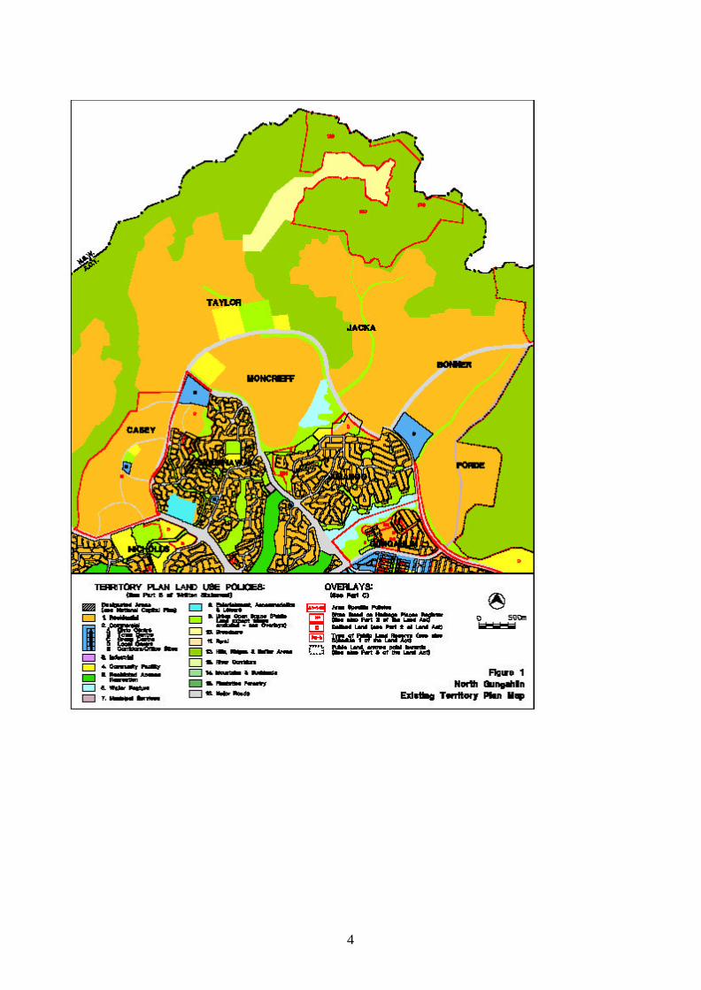
3. Changes to the Territory Plan Map The Variation redefines the basic land use policy framework of the existing Territory Plan as shown on Figure 1 and introduces a greater level of detail. Detailed planning and the landscape characteristics of the site generate a series of suburbs divided by major transport routes or open space corridors incorporating ridgelines, natural drainage lines and other significant landscape, ecological and heritage features. Mirrabei Drive, a major north-south arterial, is realigned and the collector road network identified. The Variation reflects the recommendations of engineering studies on stormwater management by replacing a single large pond with a series of smaller water quality and retardation ponds. The location of major commercial and community facilities is revised and new sites are identified for local facilities. The urban edge is further redefined together with the Hill Ridges and Buffer Area boundary. The area is covered by a Defined Land Overlay (see Section 5) to enable further refinement during later detailed planning stages. The principal planning philosophy supporting the Variation is to provide a sustainable base for the integration of the natural and human settings. The natural environment is therefore better protected and integrated with the layout of the individual suburbs. The urban environment is rearranged to provide stronger focal points for the community to use, and at the same time more intensely developed uses are sited to encourage use of public transport. The planning principles and policies for the broad structure are that: • development should encourage an environment that facilitates sustainability in terms of
ecological, cultural, social and economic considerations;
• the landscape setting and values of the site should be recognised and enhanced. Existing significant landscape features will be retained;
• the local neighbourhood should be based on a walkable radius of 400m, and focussed on an activity node such as a basic unit of open space (such as a park and potential community facility);
• residential areas should be based on a series of inter-connected suburbs (each generally containing 3 or 4 neighbourhoods) with their own local centre, typically adjoining a primary school site and open space corridor;
• mixed and multiple uses will be permitted at all levels of the urban structure;
• group centres serving larger populations should be well located on major roads in order to serve a cluster of suburbs to ensure the long term viability of the centre;
• an integrated cycling route network should be created within and between communities consistent with national standards;
• the open space system should form a continuous web of spaces that contains a sequence of destinations eg. centres, schools, parks, community facilities, ovals, ponds and hilltop lookouts;
• the road hierarchy should be clearly legible and provide good and safe access to all users and encourage high levels of public transport usage;
6
• the links between sustainable urban water management and downstream ecological impacts on flora and fauna, both through the direct impact of altered flow regimes caused by urban development and through water quality impacts partially driven by these altered flow regimes should be recognised. Appropriate sustainable urban water management measures will be adopted to protect downstream ecology; and
• Aboriginal and historic heritage place will be recognised and significant sites conserved in public open space where appropriate.
The changes to the Territory Plan Map are detailed at Attachment A of the Variation. These changes reflect the various elements of the Structure Plan. Following the Variation process, further detailed planning will be undertaken. This detailed planning could take the form of Concept Plans, Development Control Plans, Estate Development Plans and Implementation Plans, consistent with existing land use policies, design and siting codes and any relevant principles and policies for Defined Land. Other areas, notably the plans for Commercial Centres, major public open space and conservation areas, may require the preparation of Centre Master Plans and related Land Management Plans respectively. 3.1 Residential Areas The residential areas further refine the boundary between the natural landscape setting and urban development, and closely correspond to the current Territory Plan boundary. There are six new suburbs, Bonner, Casey, Forde, Jacka, Moncrieff, and Taylor, which are incorporated in the Residential Land Use Policy. The basic structure of each suburb is characterised by the following elements: • a neighbourhood or local centre, which typically incorporates a small group of buildings
(retail/commercial) together with a park and/or site for community facilities; • a linear open space network based primarily on drainage lines, incorporating pedestrian
paths and cycleways; • a clearly articulated road hierarchy where the engineering design and landscape treatment
reflect the proposed traffic function of each street; • local parks sited in locations that conserve natural or cultural heritage features wherever
possible; • defined local bus routes with bus stops within 500m of at least 95% of dwellings; and • housing choice with increased densities close to major nodes and transport corridors. The Structure Plan proposes a mixture of housing types with increased densities close to activity nodes, such as group centres and local centres. It is estimated that this will comprise around 20% of the total housing yield. In these areas the Structure Plan proposes to apply the Residential B8 and B9 Area Specific Policies. PALM has recently undertaken a review of these policies to assess their relevance in light of more recent developments in the Gungahlin Town Centre and proposed development in North Gungahlin. The proposed changes to the B8 and B9 policies are described at Section 4, (Proposed Changes to the Territory Plan Written Statement) and detailed at Attachment A, Part 2.
7
3.2 Shopping Centres The Structure Plan proposes three group centres, at Casey, Moncrieff (Mirrabei) and Amaroo, and five local centres at Bonner, Casey, Forde, Jacka and Taylor. The retail structure is consistent with the BIS Retail Study released in early 1999 and the outcomes of community consultation processes. The group centre developments will be carefully planned, being aligned with the staged development of Gungahlin. Centre sizes will be reviewed close to the time of their release, but will generally vary in site area from 4,000m2 to 10,000m2. Effective pedestrian and bicycle access will be integrated with their development, as will strong public transport links. The group centres will act as ‘nodes’ for employment, retailing, community and entertainment facilities and will provide a focal point for several suburbs. Each of the group centres will incorporate significant opportunities for the co-location of ‘urban housing’ ie. higher density multi-unit residential developments so that an effective mixed use character can be established. The residential land use policy of sites closest to the retail core will permit a vertical mix of commercial and residential uses. The five local centres aim to provide convenience shopping with ‘mixed use’ characteristics within walking distance of the adjoining residential areas. These centres will be designed to be flexible to accommodate the changes in community demands over time. Local centres will also be supported by concentrations of medium density housing which will foster the ‘mixed use’ characteristics of the precinct. 3.3 Community Facilities The Structure Plan identifies community facility sites throughout the new suburbs, introducing a greater level of detail in terms of their location. Most community facility sites are located close to commercial centres thus providing good access to public transport, open space, and schools, and facilitating a sense of community. Current site identification is based on estimated demand at the time of structure planning. Detailed facilities planning and provision is based on estimated demand and demographic characteristics before and during the development of an area. The location and distribution of facilities with specialised siting requirements and large land take, such as schools, need to be refined prior to more detailed planning. Changing community needs will affect the number and types of facilities required, resulting in the need for planning to retain a degree of flexibility. Sites for government primary schools are identified at Bonner, Jacka and Taylor. The site at Taylor is co-located with a government high school. A further site is set aside for a possible education facility (college) at Moncrieff. In addition to intended school sites, other possible community facility sites are identified within the open space system for community facilities requiring a smaller land take, such as churches, scout halls and community halls. Demonstrated demand for the development of these sites will be established in later detailed planning stages.
8
3.4 Open Space and Hills Ridges and Buffer Areas The Structure Plan emphasises the importance of urban open space as a structural element, contributing to sustainability as well as providing a recreational resource and visual amenity for the future residents of North Gungahlin. The ‘web’ of open space defines, and gives identity to, each of the six North Gungahlin suburbs as well as meeting traditional open space needs. The resultant linear open space system shown on the Structure Plan is designed not only to protect the natural drainage system and major ridgelines, but also to create the opportunity for a comprehensive off-road movement system suitable for pedestrian, cycle and, to a lesser extent, equestrian users. A further important feature of the open space system is that it connects local centres, group centres and bus routes to optimise land use relationships and to encourage multi-purpose trips. Within the suburb of Jacka, the Horse Park Homestead and Wetlands area is to be retained and protected in the urban open space system, and will be subject to specific planning policies and management practices. The area includes cultural and heritage values associated with both European and Aboriginal occupation. The wetlands are identified as an area of high aquatic ecosystem value and provide habitat for Latham’s Snipe, a species subject to international migratory bird agreements. In Forde the open space system reflects the cultural heritage significance of the Gundaroo Road, with the alignment being retained and utilised as an open space corridor. A former road alignment adjacent to Horse Park Drive near Casey, encompasses as areas of Yellow Box/Red Gum woodland which is also being retained within urban open space. Adjustments will also be made to the boundary of the Hills, Ridges and Buffer Policy Areas to reflect more detailed planning and facilitate urban edge management, including consideration of bushfire hazard reduction. Such fire mitigating measures would be reflected in a fire management plan prepared by the relevant land manager. The Structure Plan also identifies a more comprehensive and sustainable urban stormwater management system, where overland stormwater and flood movements are accommodated predominantly in road reservations and within the web of open space.
3.5 Natural Resources The principles and policies of the North Gungahlin Structure Plan and the Variation have been reviewed following the recent release of the draft ACT Lowland Woodlands Conservation Strategy for the conservation of woodland communities. They were found to be consistent in their approach to conservation and management of native vegetation and associated species. The North Gungahlin area contains a large component of remnant native vegetation that varies in terms of its ecological integrity, depending on the nature of previous land uses. The value of the area for wildlife depends to a significant degree on this previous land use history, and current land uses. The ACT Flora and Fauna Committee, established under the Nature Conservation Act 1980 is responsible for assessing the conservation status of flora and fauna in the ACT, and the ecological significance of potentially threatening processes. Where in its opinion a species
9
or community is under threat, a recommendation for declaration is made, and if adopted, an Action Plan is prepared in response by the Conservator of Flora and Fauna. An Action Plan includes proposals for the identification, protection and survival of a threatened species or community. Action plans 10 and 15-20 are the subject of assessment in the draft ACT Lowland Woodland Conservation Strategy. All Action Plans were reviewed to determine the extent of recorded information and conservation recommendations for endangered communities or vulnerable/threatened species in the ACT, and the following were found to be relevant to the North Gungahlin Structure Plan: Action Plan No. 1 Natural Temperate Grassland Action Plan No. 7 Golden Sun Moth (Synemon plana) Action Plan No. 10 Yellow Box/Red Gum Grassy Woodland Action Plan No. 15 Hooded Robin (Melanodryas cucullata) Action Plan No. 16 Swift Parrot (Lathamus discolor) Action Plan No. 17 Superb Parrot (Polytelis swainsonii) Action Plan No. 18 Brown Treecreeper (Climacteris picumnus) Action Plan No. 20 Regent Honeyeater (Xanthomyza phryga) In order to provide for balanced planning outcomes, it is not feasible to preserve all ecological elements. However, the ACT planning process allows flexibility in its approach to accommodate conservation imperatives outlined in Action Plans prepared under the Nature Conservation Act (1980). These plans indicate that some natural features are not proposed to be protected in full but elements could be considered for incorporation into the urban fabric as part of the detailed planning process. This principle is implemented in the planning for the North Gungahlin Structure Plan where ecological assets, including the Horse Park Wetland, some remnant patches of Yellow Box/Red Gum woodland such as the eucalypt arcade in Casey and some areas of Natural Temperate Grassland will be maintained and protected within open space and parks. These outcomes demonstrate that protection of the environment plays an important role in planning in the ACT and will be continued through the implementation of the North Gungahlin Structure Plan area and subsequent stages of the detailed planning process. Yellow Box/Red Gum Grassy Woodland The most significant of the woodland communities in the ACT, the Yellow Box/Red Gum (YBRG) Grassy Woodland community occurs throughout the ACT. Declaration of this ecological community as endangered in May 1997 emphasised the significance of the woodland community locally and its role in the provision of habitat for a variety of common and vulnerable animal and bird species. Very high conservation value woodland areas identified by Action Plan No. 10 and the subsequent draft Lowland Woodland Conservation Strategy (LWCS) are located in the Mulligans Flat Nature Reserve and Gooroo to the east, and Kinlyside to the west, of North Gungahlin. Smaller remnant patches (totalling 147 ha) of high conservation value woodland are identified in areas proposed for future urban development in North Gungahlin. Adjoining the eastern boundary of Forde, an area of very high and high conservation value woodland is identified in Action Plan No.10 and the draft LWCS. 19 ha of this woodland have now been incorporated into Mulligans Flat Nature Reserve under Variation to the Territory
10
Plan No. 182. The North Gungahlin Structure Plan takes this into account by modifying the structure of the proposed future suburb of Forde and incorporates planning principles and policies to address the buffer area between the future urban area of Forde and the Nature Reserve. The remaining woodland in Forde will not be retained as a woodland community, however high value individual trees and stands of trees capable of being incorporated into the urban fabric will be retained in open space. Several remnant patches of high and moderate conservation value YBRG grassy woodland are located within the North Gungahlin area. The distribution of these remnant patches within the Structure Plan, and the proposed future management options for these areas within the urban fabric are summarised in the tables below.
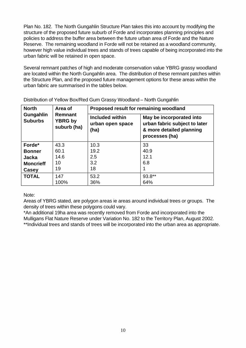
Distribution of Yellow Box/Red Gum Grassy Woodland – North Gungahlin
Proposed result for remaining woodland North Gungahlin Suburbs
Area of Remnant YBRG by suburb (ha)
Included within urban open space (ha)
May be incorporated into urban fabric subject to later & more detailed planning processes (ha)
Forde* Bonner Jacka Moncrieff Casey
43.3 60.1 14.6 10 19
10.3 19.2 2.5 3.2 18
33 40.9 12.1 6.8 1
TOTAL
147 100%
53.2 36%
93.8** 64%
Note: Areas of YBRG stated, are polygon areas ie areas around individual trees or groups. The density of trees within these polygons could vary. *An additional 19ha area was recently removed from Forde and incorporated into the Mulligans Flat Nature Reserve under Variation No. 182 to the Territory Plan, August 2002. **Individual trees and stands of trees will be incorporated into the urban area as appropriate.
11
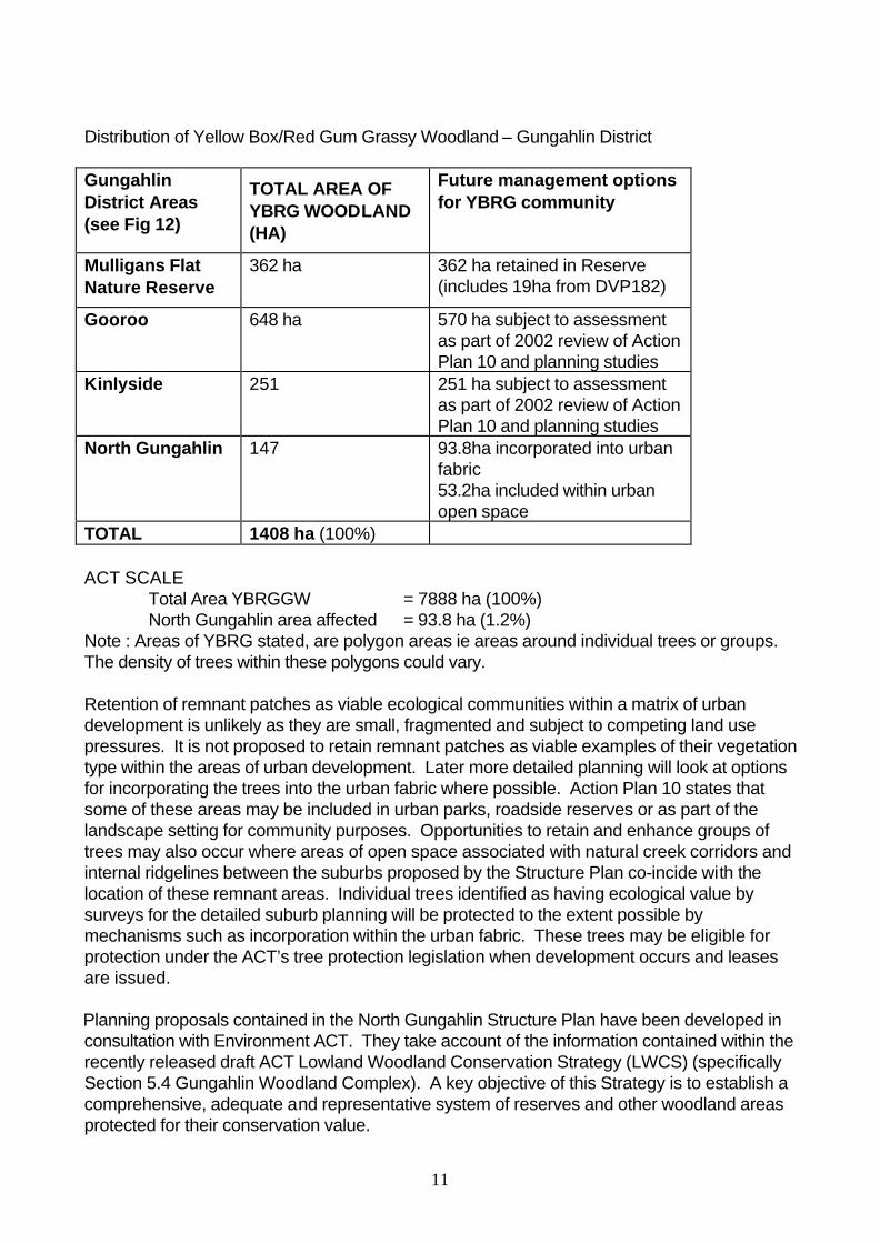
Distribution of Yellow Box/Red Gum Grassy Woodland – Gungahlin District Gungahlin District Areas (see Fig 12)
TOTAL AREA OF YBRG WOODLAND (HA)
Future management options for YBRG community
Mulligans Flat Nature Reserve
362 ha 362 ha retained in Reserve (includes 19ha from DVP182)
Gooroo 648 ha 570 ha subject to assessment as part of 2002 review of Action Plan 10 and planning studies
Kinlyside 251 251 ha subject to assessment as part of 2002 review of Action Plan 10 and planning studies
North Gungahlin 147 93.8ha incorporated into urban fabric 53.2ha included within urban open space
TOTAL 1408 ha (100%) ACT SCALE
Total Area YBRGGW = 7888 ha (100%) North Gungahlin area affected = 93.8 ha (1.2%)
Note : Areas of YBRG stated, are polygon areas ie areas around individual trees or groups. The density of trees within these polygons could vary. Retention of remnant patches as viable ecological communities within a matrix of urban development is unlikely as they are small, fragmented and subject to competing land use pressures. It is not proposed to retain remnant patches as viable examples of their vegetation type within the areas of urban development. Later more detailed planning will look at options for incorporating the trees into the urban fabric where possible. Action Plan 10 states that some of these areas may be included in urban parks, roadside reserves or as part of the landscape setting for community purposes. Opportunities to retain and enhance groups of trees may also occur where areas of open space associated with natural creek corridors and internal ridgelines between the suburbs proposed by the Structure Plan co-incide with the location of these remnant areas. Individual trees identified as having ecological value by surveys for the detailed suburb planning will be protected to the extent possible by mechanisms such as incorporation within the urban fabric. These trees may be eligible for protection under the ACT’s tree protection legislation when development occurs and leases are issued. Planning proposals contained in the North Gungahlin Structure Plan have been developed in consultation with Environment ACT. They take account of the information contained within the recently released draft ACT Lowland Woodland Conservation Strategy (LWCS) (specifically Section 5.4 Gungahlin Woodland Complex). A key objective of this Strategy is to establish a comprehensive, adequate and representative system of reserves and other woodland areas protected for their conservation value.
12
The draft LWCS concluded that significant conservation gains can be made, by avoiding greenfield development in areas containing large areas of Yellow Box/Red Gum woodland. In its initial response to the draft LWCS, the Government has announced that about 750Ha of Yellow Box/Red Gum and other lowland woodland types in the Gooroo area will be protected in a new Nature Reserve. This area includes land that was originally scheduled for development as parts of new suburbs for Gungahlin. It contains woodland in good ecological condition, which forms a major link between Mulligans Flat and Majura Nature Reserves and retains habitat suitable for vulnerable woodland birds including the Hooded Robin and Brown Treecreeper (Vulnerable species). It is intended, where appropriate, to incorporate suitable trees and stands of trees into the urban fabric of the proposed North Gungahlin suburbs. Detailed planning for Forde has identified three groups of mature Yellow Box/Red Gum trees that will be protected within urban open space areas. This will result in some habitat elements being retained for native fauna tolerant of urban environments. An additional 19ha of Yellow Box/Red Gum Grassy Woodland was added to the Mulligans Flat Nature Reserve as a result of DVP 182 in April 2002. Other woodlands Both botanical and ecological values are also attributed to other woodland communities, primarily for wildlife habitat and wildlife corridors. North Gungahlin contains areas of regenerating woodland that are of potentially high conservation value in the context of the ecological resources of the ACT and the local area. The proposed urban development will impact on these other woodland communities. The North Gungahlin Structure Plan limits development on the higher slopes, and considered the presence woodlands in the design and location of the outer edge of urban development. The Structure Plan retains the woodland communities to the north as a continuous native woodland corridor in the Hills, Ridges and Buffer areas land use policy of the Territory Plan, and NCOSS under the National Capital Plan. The scattered nature of small, fragmented woodland areas across the lower slopes of the study area makes their integration and/or conservation as isolated communities within the urban fabric virtually impossible. However, it is anticipated that there will be trees that have individual value independent of their role in a forest or woodland ecosystem ie trees with particularly good nesting hollows. A tree survey conducted during the detailed planning stage for each suburb will identify trees with high ecological values. Further design work at the detailed planning stage will then offer feasible retention and protection options for these trees within the urban area, such as incorporation in small parks, village centres and road reserves. These trees also may be eligible for protection under the ACT’s tree protection legislation when development occurs and leases are issued. Forestry Plantation The plantation area to the north of the urban development area of North Gungahlin was established for the production and supply of fuelwood for the ACT. The eucalypt plantings have been in place for over 20 years, during which time they have matured sufficiently to integrate with the existing native woodland vegetation in that location, to form a modified woodland community, to which some ecological and landscape value can now be attributed.
13
The implementation of the North Gungahlin Structure Plan will not have any impact on this plantation. Future harvesting for fuelwood is unlikely to occur. As a result it will be allowed to mature and contribute to the continuous woodland corridor skirting the north of the ACT along the NSW border. The decision not to harvest the plantation to provide a supply of fuelwood to the ACT is also consistent with current initiatives aimed at the reduction of the use of fuelwood appliances, to prevent deterioration in air quality over the ACT. Individual trees and stands of trees within the areas of forward tree plantation in Jacka and Taylor are to be incorporated into the urban fabric where practicable for landscape purposes. Natural Temperate Grassland Due to its pastoral history, very little of the native grassland community thought to have existed in the Gungahlin area now remains. Declaration of the Natural Temperate Grassland as an endangered ecological community in April 1996 recognised the decline in the distribution of the grassland community and its changing composition as a result of land use history. Action Plan 1 in its recognition of the decline of this community identified several areas of natural temperate grassland in the Gungahlin District, three of which are protected in reserves to the south of the North Gungahlin Structure Plan area (Mulanggarri, Gungahlin and Crace Nature Reserves). The Action Plan assessed the area of grassland identified in the North Gungahlin area as having moderate to low botanical significance. As other better examples of higher order grassland are reserved in the Gungahlin area, not all of the grassland in North Gungahlin will be retained, though parts may be kept as landscaped feature elements within the urban fabric. Development of the proposed future suburb of Bonner will impact on Grassland Action Plan Site No.1. The Action Plan has assigned a moderate botanical significance rating to the 10.3 ha Wet Themeda component of this grassland, and a low conservation value to the remaining 21.8 ha Danthonia grassland. The Structure Plan does not propose to retain the entire grassland area although parts may feature as landscape elements within the urban fabric such as within areas of open space associated with natural drainage lines, internal ridgelines and/or local parks. Further consideration of these options will occur at later detailed planning stages. Parts of the grasslands are habitat for an uncommon plant species, the Emu Foot Cullen tenax. The species has also been recorded at a site on the eastern side of Gundaroo Rd in the proposed urban areas of Forde. Further investigations of the Forde location by Environment ACT have shown that there are only a few plants in a very degraded site. Environment ACT has advised that the site is not worthy of retention nor is translocation of the few plants from this location. Further consideration of this species in the Bonner area will be required in conjunction with Environment ACT at the detailed planning stage to determine future management options. Wetlands The Horse Park Wetland is identified as the most significant wetland within the North Gungahlin area, and in the Gungahlin District. The significance of its cultural and ecological values is demonstrated by its listing as part of the Horse Park precinct on the Register of the National Estate, inclusion in “A Directory of Important Wetlands in Australia”, classification by the National Trust of Australia (ACT) and nomination for listing on the ACT Heritage Register.
14
The Directory of Important Wetlands in Australia noted the potential threat to the Horse Park wetlands from suburban development, and that it needed to be carefully managed to minimise impacts on the hydrology of the site. Potential impacts on the population of Latham’s Snipe by domestic pets was also noted. The Structure Plan proposes to protect the wetland by including it within a substantial area of Urban Open Space (generally incorporating the curtilage boundaries identified by the Register of the National Estate listing for the wetland) which will be subject to specific planning policies and management practices. At the detailed planning stage, further consideration of sensitive edge development, access options and future permissible uses for passive recreation will be undertaken. The conservation of this wetland within an urban environment depends not only on its physical protection, but also on regulating the flow and quality of water flowing into it from future urban development. Options for managing stormwater with a view to maintaining the natural flow regime through the wetland will require further investigation. A decision on the appropriate action will depend on detailed evaluation of geotechnical and hydraulic investigations of the areas around the wetland. Other wetland and aquatic ecosystem habitat occurs through drainage lines in the North Gungahlin area. The possible treatment of these areas to enhance their ecological values, consistent with the principles of sustainable urban stormwater management, will be subject to further investigation during later detailed planning stages in the land development process. Wildlife North Gungahlin and the surrounding region support a diversity of native mammals, birds, reptiles and invertebrates. The presence of many of these species in the area can largely be attributed to high value habitat contained within the various types of woodland and grassland communities found throughout the region. Action Plans have been prepared for the ecological communities and species listed as threatened in the ACT and several of these items occur in the North Gungahlin area. Earlier in this section, Action Plans for YBRG Grassy Woodland community and Natural Temperate Grassland communities were discussed, including Structure Plan proposals for the incorporation of elements of these communities in the future development. Coupled with the existing reservation of large tracts of the YBRG Grassy Woodland community in the Mulligans Flat Nature Reserve, high quality habitat beneficial to their associated fauna species will be retained elsewhere. Five bird species, declared as either vulnerable or endangered, which are known to occur in the North Gungahlin area, are the subject of Action Plan No.s 15 to 18 and 20. For each of the identified species, their distribution occurs predominantly in and around the Mulligans Flat Nature Reserve, and in some instances the Gungahlin District, including the Village of Hall and its environs. The major habitat for these bird species is the YBRG grassy woodland, and the retention of large tracts in the Mulligans Flat Nature Reserve and the adjoining area of Gooroo will create one of the largest areas of protected endangered communities of this type in the region, making a substantial contribution towards the achievement of the Action Plan conservation objectives for these threatened bird species.
15
In addition to the areas of woodland retained around the periphery of and adjacent to the North Gungahlin development area, the proposed ‘web’ of open space throughout North Gungahlin will also contribute to a network of natural corridors, linking key areas of habitat within the urban fabric to these peripheral areas. Principles and policies are included in the Structure Plan to address the management of the buffer areas between the proposed future suburbs and the Nature Reserve. While it may not be feasible to preserve the entire ecological community within the urban fabric, the habitat value of individual trees and stands of trees, and their landscape amenity value will be retained. Additional habitat resources for some bird species can be expected in the longer term from native gardens established by new residents. As discussed in the wetlands section above, a substantial area incorporating the Horse Park wetlands is to be placed into Urban Open Space as public land with specific management requirements. This action, in part, responds to the habitat value of the wetlands for the migratory Latham’s Snipe, and recognition of the importance of retaining this wetland habitat within the future North Gungahlin development area. The large curtilage area retained will assist to prevent intrusion of the wetlands by domestic pets from the surrounding areas. The wetland will also provide habitat for several of the frog species known to occur in North Gungahlin. The Structure Plan proposes to retain the creeks and corridors to minimise change within the urban fabric in their natural location, where possible, assisting ecological connectivity through the urban area. Several off-line ponds proposed by the Structure Plan to contribute to the management of stormwater may also contain some alternative habitat value for frogs and other species in place of farm dams, removed as the development front progresses. The endangered Golden Sun Moth (Action Plan No. 7) has been recorded at Mulligans Flat North, in the hills, ridges and buffer area north of the proposed North Gungahlin urban area. This area is already contained in the Mulligans Flat Nature Reserve, on the northern side of Gundaroo Road. The Structure Plan does not propose any disturbance or development of this area. Mulligans Flat Nature Reserve provides a refuge and habitat for the known reptile species that occur in North Gungahlin. The potential impact of the Structure Plan on these species outside the Nature Reserve due to habitat disturbance and destruction will be significant given previous experience with land development. In addition, there is not a strong tolerance to many reptile species, particularly snakes, by residents in urban areas, so retention or improvement of remnant habitat areas by residents, such as occurs for birds, is unlikely to occur.
3.6 Urban Edge Interface
To ensure that the level of risk from the threat of bushfire is reduced at the interface with the new suburbs, the Structure Plan recognises provision for buffer or fire management zones extending into the Hills Ridges and Buffer areas of the Territory Plan to create a fuel load modified area between the residential and bushland areas. These zones may range in width, depending on adjacent topography and aspect. In addition to their function for fire management, these zones will also contain a service corridor that may include infrastructure

16
services, access tracks for land management purposes, recreation trails, and catch drains for water management purposes in accordance with the Urban Edge Zone section of the Canberra Landscape Guidelines.
The Hills Ridges and Buffers land use area boundaries are adjusted at the suburb interface to reflect more detailed planning and consideration of topographic features surrounding and within the new suburbs. Whether the interfaces are permanent or in transition, (ie the interface is only temporary due to further development) they will require different management applications to mitigate the impact of bushfires on the immediate community. These adjustments will continue to be made during later detailed planning stages. Bushfire Mitigation As a general rule, protecting the community from bushfire impacts requires the integration of four major policy strategies, of which land use planning and urban design may be addressed through the Structure Plan. An objective of bushfire mitigation in planning is to ensure that the level of fire risk is reduced and the level of fire protection is improved at interface areas. Key issues to be considered in planning to achieve this objective include: • Consideration of topographic features • Inclusion of a bushfire protection zone within buffer zones • Landscape design and vegetation type • Road design and location that ensures multiple safe access and egress points for fire
fighting and evacuation, • Water requirements, ensuring a sufficient supply at the interface and • Design and siting of buildings. The urban edge design and management will be consistent with vulnerability assessment, based on topographic features, fuel loads, prevailing climatic conditions and key planning considerations as listed above. Mulligans Flat Nature Reserve To fulfil this important conservation requirement, the proposed buffer area for the urban interface between Forde and Bonner with the Mulligans Flat Nature Reserve will contain several elements to create an overall zone that is managed primarily for bushfire protection but endeavours to maintain conservation values where compatible. The zone will include a fenced area within the standard buffer between the urban area and Nature Reserve. This will create a higher maintenance conservation management area within the buffer area. This conservation management area will assist in reducing the potential impacts associated with nearby residential areas including the incursion of weeds, predation by domestic pets, dumping of rubbish, inappropriate access and removal of plants/timber. This buffer will also form part of the fire management zone, similar to that described earlier in this section between residential areas and Hills Ridges and Buffer land use areas or the Nature Reserve. Equestrian Trails An off-road trail for equestrian and other uses is intended to follow the urban edge. It will link the existing National Trail entering the ACT from NSW along Gundaroo Road, with the existing trail, showground and horse facilities at Hall to the west of North Gungahlin. It will require the widening of the road reserve alongside Gundaroo Road where it passes adjacent to the Nature Reserve to accommodate the parallel trail, then follows the edge of the existing urban development and will move incrementally as the urban edge develops.
17
This urban edge trail will function both as a local equestrian trail and as a section of the National Trail. Future planning studies will investigate opportunities for further development of recreation/equestrian trails in North Gungahlin, including the possibility of trails extending into the Hills, Ridges and Buffer areas. 3.7 Transport Network The transport network is comprehensive, including roads, an inter-town public transport route (IPT), local bus routes, cycle ways and pathways. The road network has been established using a range of road types including arterial, boulevard, avenue, local road, minor road and laneways. A feature of the boulevards is the provision of service roads, which allow for residential frontage but not necessarily access to these key roads. They will also contain continuous verge planting, footpaths and trunk cycle paths. Avenues are a smaller version of boulevards, without the service roads and catering to a lower vehicle capacity. The collector road network is designed to maximise public transport usage, with the pedestrian and cycle network linking residential areas with schools, commercial centres and recreational resources. Generally roads of collector status and above are shown on the Structure Plan. Of the two key roads for the North Gungahlin area, Horse Park Drive provides the trunk route in and out of the area. It protects existing and planned urban areas from traffic infiltration and directs traffic to destinations outside of Gungahlin. Horse Park Drive is supplemented by Mirrabei Drive, which provides the direct connection from the northern areas of Gungahlin to the Town Centre. Both the alignments of Horse Park and Mirrabei Drives are slightly changed to reflect the new structure. The Gungahlin IPT is a major public transport corridor, which runs along Flemington Road, through the Town Centre to Mirrabei Drive, and terminates at the Moncrieff Group Centre. The collector road network is designed to encourage greater public transport usage and supplement the ITP system. The road network satisfies the ACTION criteria, by requiring 90% of dwellings to be located within 400m of a bus route and 95% of dwellings to be within 500m of a potential bus stop. An extensive off-road equestrian/recreation and cycle network is proposed, as part of the open space system, to serve the Town Centre, schools and other activity nodes. An off-road network will also be provided serving main employment centres and connections to the ITP route.
3.8 Stormwater Management Recent research and a better understanding of catchment land use and management practices since the initial planning of Gungahlin, has identified more sustainable management practices that improve water quality in receiving waters, enhance ecological values and amenity, reduce potable water demand, and potentially provide long term cost savings. Sustainable urban water management design principles are to be adopted for the development of North Gungahlin. The principal objective is to secure economic, social and environmental benefits of integrated ‘water in the landscape’ (including water sensitive design techniques) and ‘total water cycle’ based designs to achieve a balance of water across the landscape, at the block, neighbourhood, district and catchment levels.
18
The Structure Plan incorporates a more comprehensive stormwater system, where overland stormwater and flood movements are accommodated mainly in the proposed web of urban open space. The proposal for a linked park system allows for a number of other goals to be achieved in addition to management of stormwater, including provision for off road bicycle paths and walking trails, and the provision of wildlife corridors. This is consistent with current thinking where stormwater is now regarded as a major resource rather than a problem to be exported as quickly as possible. The stormwater strategy embodied in the Structure Plan also allows the opportunity for smaller ponds to be constructed as shown on the Structure Plan Map (See Figure 2). These are capable of being designed with a more natural appearance than the larger ponds, and for water quality reasons will be constructed “off-line”, ie to the side of the creek rather than on the line of the creek (such as the facility on David Street in Turner). Their benefits are related to the establishment of water features and habitats within the open space system, as well as assisting with stormwater management. The proposed large water quality control pond between Amaroo and Moncrieff is replaced by a series of smaller, localised ponds further upstream. A small pond will still be required together with a dry retardation basin for flood management purposes. It is proposed, as a secondary use, that the district playing fields associated with the proposed Amaroo High School be located within the dry retardation basin.
4. Proposed Changes to the Territory Plan Written Statement Residential B8 and B9 Area Specific Policy Review
The Variation amends two of the area specific policies in the residential policies in the Territory Plan Written Statement. The B8 area specific policy aims to allow for higher density mixed use development and provides for residential development up to a maximum of four storeys. Small scale offices, restaurants, community facilities and shops may be permitted at ground floor level. The B9 area specific policy aims to provide for a range of intensive residential uses including a variety of medium to high density housing types. The policy allows for development up to three storeys.
The B8 and B9 policies apply to land adjacent to the Town Centre in the Gungahlin Central Area. The North Gungahlin Structure Plan promotes higher density development in strategic locations close to activity nodes, such as at group and local centres by also applying the Residential B8 and B9 Area Specific Policies in these locations.
4.1 Residential B8 Area Specific Policy
While the concept of mixed uses and higher densities is supported, some of the controls and uses in the B8 policy were not considered appropriate in a mixed-use context. This Variation amends the B8 policy as follows:
(i) The title and objectives of the policy have been amended to be more generic and have a wider application.
19
(ii) Some of the uses have been deleted as they are inappropriate or unnecessary in a mixed-use context. These include:
• Car park (only appropriate as an ancillary use) • Club (Impacts not appropriate and more likely to be located in commercial areas) • Emergency services facility (Impacts not appropriate) • Outdoor recreation facility (Large land take facilities not consistent with intensive
higher density development. Smaller facilities may occur as ancillary to Parkland.) • Recyclable materials collection (Scale and impacts not appropriate) • Service station (Impacts not appropriate) • Place of Assembly (Scale not appropriate, more likely to occur as community activity
centre) (iii) The land use restrictions at Clause 2.10 and Performance Controls of the Residential
Policy have been exempted and individual uses have been replaced with the Group definitions listed below:
COMMUNITY USE means a child care centre, a community activity centre, a community theatre, a cultural facility, an educational establishment, a health facility, a hospital, a place of worship, and/or a religious associated use. COMMERCIAL ACCOMMODATION USE means a commercial accommodation unit, guesthouse, hotel, motel or tourist resort but does not include a caravan park/camping ground or group or organised camp. (refer Variation 158, Group Centre Policies) NON RETAIL COMMERCIAL USE means a business agency, financial establishment, office or public agency. (refer Variation 158) The changes have the effect of removing some of the restrictions on gross floor area, concentration and location that apply to uses such as guest house, community activity centre and health facility, through the general residential policy. The former B8 policy did not treat additional uses consistently because not all uses were subject to the more general restrictions in the Residential Policy. In the standard residential context, the restrictions are aimed at protecting amenity and ensuring development is compatible with the surrounding residential area. However the general residential controls are not considered appropriate in a mixed-use context.
(iv) New controls have been introduced for noise attenuation for potential noise generating uses where they are located adjacent to residential/ commercial accommodation use.
(v) The gross floor area restriction of 200m2 has been applied to other relevant uses to
limit the scale of development and potential impacts on town/commercial centres and adjacent residential development. These include:
• COMMUNITY USE • Craft workshop • Drink establishment
The restriction has been clarified so that it applies per tenancy as well as per establishment.
20
(vi) The restriction on upper floor uses has been reworded to limit uses, other than
residential or commercial accommodation, to the ground floor level. (vii) The building height control has been amended to specify a general building height of 3
storeys. However buildings up to a maximum of 4 storeys may be permitted where provided for in a Building Envelope Plan.
A Building Envelope Plan is a plan that specifies building envelopes and any other specific block development controls and is linked to, and approved along with, an Estate Development Plan. An Estate Development Plan sets out the proposed pattern of subdivision and infrastructure works for an estate. This Estate Development Plan needs to be approved before works are undertaken and leases are granted for the subdivided blocks. The Estate Development Plan may also include a streetscape concept plan. Estate Development Plans will need to be prepared for logical parcels of land before development proceeds.
(viii) The Design and Siting Clause has been amended to apply the Urban Housing Code to multi unit development. This code is based on the Australian Model Code for Residential Development and was introduced in conjunction with the Residential B11 and B12 Area Specific Policies to promote well-designed medium density development.
4.2 Residential B9 Area Specific Policy This Variation also amends the title and objectives of the B9 policy so that they now apply to areas beyond the Gungahlin Town Centre. The clause relating to building height has been amended to refer to the term ‘Building Envelope Plan.’ The Design and Siting Clause has been amended to apply the Urban Housing Code to medium density development.
5. Defined Land The Variation identifies the North Gungahlin Structure Plan area as defined land in accordance with the provisions of the Land Act. The Territory Plan Map is amended to add the defined land overlay to the site. Section 7(3)(e) of the Land Act states that where the Territory Plan identifies land as Defined Land, it shall also set the principles and policies for its development. It is important that the planning of an area the size of North Gungahlin is not unduly constrained during its period of development. The Defined Land process enables the Territory Plan to be progressively updated in line with the current best practices while maintaining principles and policies identified for each area. In summary, the process is: • The land is identified as Defined Land and the principles and policies for its development
are set out in the Territory Plan through the normal Plan Variation process; • Detailed subdivision plans for the development of the site are prepared progressively in
accordance with the principles and policies set out in the approved Variation; and
21
• On approval of the subdivision plans, PALM subsequently varies the Territory Plan by a notice in the ACT Legislation Register pursuant to section 32 of the Land Act. This Variation specifies the boundaries and purposes for which the various parts of the land may be used. On commencement of the subsequent Variation, the land ceases to be Defined Land.
The principles and policies for the development of Defined Land are detailed at Part 3 of Attachment A.
6. Consultation on the Draft Variation
The Variation was released as a draft for public comment in October 2002 with comments closing on 20 December 2002. Written submissions received on the draft Variation were made available for public perusal. Comments from the Conservator of Flora and Fauna received prior to the release of the draft Variation were considered in preparing the document for public release. A Preliminary Assessment (PA) was released for comment in parallel with the Draft Variation to the Territory Plan. The PA evaluation concluded that potential impacts of the proposal on the environment were adequately addressed and no further environmental impact assessment would be required. The PA evaluation report made a number of recommendations which have been considered in finalising the Variation. Issues raised in the submissions were considered by PALM and a report was prepared and submitted to the ACT Executive. Reports on consultation with the Conservator of Flora and Fauna, the National Capital Authority and the ACT Heritage Council were also submitted to the Executive.
Since the release of the draft Variation, Environment ACT has completed a review of Action Plan 10 (Yellow Box/Red Gum Grassy Woodland). This review takes into account significant areas of Yellow Box/Red Gum Grassy Woodland requiring further study at Gooroo (East Gungahlin) and Kinlyside, both adjacent to the area subject to this Variation. The outcomes of this study are part of a draft ACT Lowland Woodland Conservation Strategy (Action Plan 27). The outcomes of this review have been taken into consideration in finalising the North Gungahlin Structure Plan and the principles and policies are consistent with the draft Lowland Woodland Conservation Strategy.
7. Revision of the Draft Variation
A number of revisions have been made to the Variation as a result of the consultation and preliminary assessment process. These are described below.
• The National Capital Authority raised the issue of the proposed arterial road connecting Gungahlin and NSW and advised that an amendment to the National Capital Plan would be required if PALM intended to delete the connection. Although a road is permitted in this location under the Hills Ridges and Buffer Areas Policy in the Territory Plan, the connection has been reinforced in the principles and policies. In particular, at Attachment A, 3.1 General Planning Principles and at 3.2 Suburbs, Bonner new principles have been added to maintain road connection with Gundaroo Road and NSW. The proposed North Gungahlin Structure Plan, Figure 2, has been updated to reflect the extension of Gundaroo Road, as have the Outline Plan Generators (Figures 5,6)
22
• Following the preparation of the draft Variation, detailed planning studies have been undertaken for Forde, which have led to revisions in the principles and policies for that suburb. In particular, specific policies for Forde have been amended to increase areas for open space and retention of endangered species, increase the number of major road access points to the suburb and clarify the alignment of the open space spine. The Outline Plan generators for Forde have been amended accordingly (Figures 3,4).
• Since the draft variation was released, detailed subdivision plans have been prepared for several areas in the suburb of Amaroo and the Defined Land Overlay no longer applies in these circumstances. Consequently the Defined Land overlay at Figure 1 in the Explanatory Statement and Figure 2 in Attachment A has been amended. Land use policies have also been amended to reflect the Amaroo community precinct. (Refer also to Figure 15 Ngunnawal/ Amaroo Outline Plans).
• The statistics in Section 3.5 in the Explanatory Statement relating to the Distribution of Yellow Box/Red Gum Grassy Woodland – North Gungahlin have been changed to reflect the increased retention of woodland in revised planning for Forde.
• References to the review of Action Plans in the Explanatory Statement have been updated in accordance with the release of the draft ACT Lowland Woodland Conservation Strategy.
• An additional General Planning Principle has been added to Attachment A relating to urban edge design in response to bushfire inquiry outcomes.
• Section 5.6 Urban Edge Interface has been updated in light of the recent bushfire, to include details on bushfire mitigation and urban edge planning principles. The term equestrian in parentheses has been removed from paragraph one, to reflect the mixed-use nature of recreation trails.
• The boundary of the 12C Hills Ridges and Buffer Areas Area Specific Policy and the Defined Land Boundary have been adjusted in Figure 2 to follow the urban edge. The 12 C Area specific Policy defines the Eucalypt Plantation.
• The Public Land boundary in Figure 2 has been corrected to follow the boundary of the Mulliganas Flat Nature Reserve established by Variation 182 in September 2002.
23
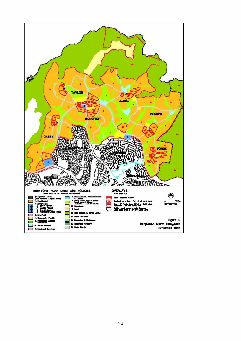
ATTACHMENT A
1. Variation to the Territory Plan Map
The Territory Plan Map is varied for the area identified as “Area Subject to the Variation” as follows:
1. Residential Land Use Policy
• define the suburbs of Bonner, Casey, Forde, Jacka, Moncrieff, and Taylor and adjust the suburbs of Amaroo and Ngunnawal.
• add Residential B8 and B9 Area Specific Policy Overlays.
2. Major Roads Land Use Policy • amend alignments of Horse Park Drive and Mirrabei Drive and identify internal
road network.
3. Commercial Land Use Policy • relocate the two group centres previously proposed at Forde and at the
intersection of Horse Park and Mirrabei Drives and identify a third group centre at Casey.
• identify five local centres in the suburbs of Bonner, Casey, Forde, Jacka and Taylor.
4. Urban Open Space Land Use Policy
• define revised open space system.
5. Community Facility Land Use Policy • identify community facility sites. • Confirm the Amaroo community precinct
6. Water Feature Land Use Policy • reduce the size of the water management pond in Amaroo and identify a series of
smaller ponds.
7. Hills Ridges and Buffer Areas Land Use Policy • revise the urban development edge, • adjust the boundary of the 12C Area Specific Policy, Eucalypt Plantations
Gungahlin, and
8. Add the Defined Land Overlay.
as indicated in Figure 2.
24
25
2. Variation to the Territory Plan Written Statement
(i) At Part B1 Residential Land Use Policies, Clause 4 Area Specific Policies replace Area B8 Gungahlin Town Centre – Residential Mixed Use, as follows:
“Area B8: Residential Mixed Use Objectives
• To promote a range of intensive residential uses combined with
appropriate non-residential uses in highly accessible locations adjacent to the Gungahlin Town Centre and other identified commercial centres.
• To provide for small-scale leisure, recreation, community and commercial activities in conjunction with intensive residential development.
Controls Land Use Add to Schedule 1: Communications facility+, COMMERCIAL ACCOMMODATION USE, COMMUNITY USE, Craft workshop, Drink establishment+, Indoor entertainment facility+, Indoor recreation facility, NON RETAIL COMMERCIAL USE, Pedestrian plaza, Restaurant and Shop.
+ may be subject to mandatory preliminary assessment in accordance with Appendix II of the Plan.
Land Use Restrictions
COMMUNITY USE, Craft workshop, Drink establishment, Indoor entertainment facility, Indoor recreation facility, NON RETAIL COMMERCIAL USE, Restaurant, Shop
• shall be designed and located to minimise impacts on residential or commercial accommodation development. All noise-generating activities are to meet relevant criteria including Environment Protection Regulations.
• shall not be permitted above ground floor level.
• except for Indoor recreation facility shall be limited to 200m2 in gross floor area per establishment or tenancy.
COMMUNITY USE, COMMERCIAL ACCOMMODATION USE – relevant land use restrictions at Clause 2.10 do not apply.
26
Building Height
Replace Clause 2.2 with: The maximum height of buildings shall generally be 3 storeys. Buildings may be built to a maximum of 4 storeys where provided for in an approved Building Envelope Plan.
Design and Siting
Development of multi unit housing shall be in accordance with the Urban Housing Code at Appendix III.3 or its replacement.
Performance Controls
COMMUNITY USE, COMMERCIAL ACCOMMODATION USE Home business – relevant performance controls at Clause 2.11 do not apply.”
(ii) At Part B1 Residential Land Use Policies, Clause 4 Area Specific Policies replace Area B9 Gungahlin Central Area – Residential, as follows:
“Area B9 Urban Residential “Objectives
• To promote a range of intensive residential uses including a variety of
medium and high density housing types adjacent to commercial centres.
Controls
Building Height
Replace Clause 2.2 with: The maximum height of buildings shall generally be 2 storeys. Buildings may be built to a maximum of 3 storeys where provided for in an approved Building Envelope Plan.
Design and Siting
Development of multi unit housing shall be in accordance with the Urban Housing Code at Appendix III .3 or its replacement.
27
3. Principles and Policies for Development of Defined Land Section 7(3)(e) of the Land Act states that where the Territory Plan identifies land as Defined Land, it shall also set the principles and policies for its development. The Land included in this Variation is proposed to be 'Defined Land' pursuant to section 7(3)(e) of the Land Act. The Defined Land process establishes that the development of this land must be consistent with the Principles and Policies contained in this Variation. In addition the process enables the Territory Plan to be progressively updated as the detailed designs for the area unfold.
3.1 General Planning Principles
• The development of North Gungahlin should incorporate sustainability principles including economic, social, cultural and economic considerations.
• The landscape setting and values of the North Gungahlin urban area are to be recognised and enhanced. Boundary hills and significant internal ridges within the urban fabric are to be protected from development and planted with native vegetation. Significant trees should be incorporated into the urban fabric where possible.
• Conservation and Heritage Precincts such as Horse Park Homestead and Wetlands are to be retained and protected within urban open space.
• Detailed planning is to take advantage of the natural, cultural and heritage characteristics of the area and extend them to create a program to support and strengthen the community’s identity.
• The local neighbourhood is to be based on a walkable radius of 400m, and focussed on an activity node such as shops, community facility or school.
• Community facility sites should be located close to public transport and in places where, for reasons of safety, people already have a cause to congregate particularly at shopping centres and schools.
• Public open space, within close proximity to, local centres, together with various other nominated sites, may be utilised for possible community and recreation facility uses. The size and type of facility will be determined at a later detailed planning stage.
• Retail centres serving larger populations should be well located on major roads in order to serve a cluster of suburbs and ensure the long-term viability of the centre.
• Sustainable urban water management design principles are to be adopted to secure economic, social and environmental benefits of integrated ‘water in the landscape’ (including water sensitive urban design techniques) and ‘total water cycle’ based designs to achieve a better balance of water across the landscape.
• An integrated cycling and pedestrian network should connect commercial centres, schools, parks, ovals, and hilltops and provide links to trunk routes.
• The road hierarchy should be legible and provide good and safe access to all users and encourage high levels of public transport usage. Boulevards and Avenues are identified in specific locations.
• Subdivision design should encourage housing diversity and enhance access to energy efficient house design. Higher density residential development is to be located around activity nodes and transport routes.
28
• The national equestrian trail will be planned to move incrementally to follow the urban edge as development areas progress.
• Major public utilities are to be provided as required.
• Aboriginal and historic heritage places are to be recognised and significant sites conserved in public open space where appropriate.
• Road connectivity with Gundaroo Road is to be maintained
• The urban edge will be designed in accordance with any agreed outcomes of inquiries and reviews following the recent bushfires in the ACT
3.2 Suburbs The Outline Plan generators diagrams and the Outline Plans indicate the manner in which the Territory Plan will be implemented for each suburb. The Outline Plans are included to assist in the understanding of the implications of the Variation to the Territory Plan. Only the primary road system is shown on the Outline Plans and the alignments are representative of the planning intentions. The Outline Plans indicate the location of the various land uses proposed for each suburb and reflect the requirements shown on the Outline Plan generators diagrams.
29
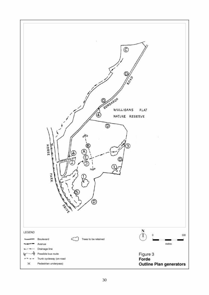
Forde Forde is a highly defined suburb being contained by Mulligans Flat Nature Reserve, the Gundaroo Road connection into NSW and the major east-west arterial, Horse Park Drive. The suburb is located in the south east of the Structure Plan and is adjacent to the Gungahlin Town Centre. GENERAL POLICIES (Refer to Fig. 3) A. The local centre, will incorporate and be adjacent to areas of high density residential, community facilities and the central open space spine. B. A local bus route will be accommodated through the suburb via the local centre and areas of higher density. C. A water detention feature is required to the north and is to be located within the natural
drainage line in open space. D. Edge roads to be utilised wherever possible as a buffer between residential development
and areas of open space. An edge road shall be predominantly used as a buffer where the adjoining open space contains substantial cultural heritage or environmental value.
E. Provide an area close to the local centre for a community facility site. F. Provide for an urban edge trail (equestrian and other uses) that will move incrementally as
the urban edge develops. SPECIFIC POLICIES (Refer to Figs. 3 and 4) 1. Several areas are identified for open space, parkland, specifically to protect existing
remnant tree patches with conservation values and to create an active recreation interface with Mulligans Flat Nature Reserve.
2. The main road access to the suburb from Horse Park Drive is to be of boulevard character
up to the first major southern intersection. 3. An open space spine, along the natural creek line, is proposed through the suburb linking
Mulligans Flat to the central and mixed-use higher density housing area. This spine will also accommodate such facilities as pedestrian pathways and cycleways.
4. Gundaroo Road reservation (within Forde) is to be retained in urban open space, thereby
preserving the existing lines of trees. To the north, Gundaroo Road will form a buffer between the urban edge and Mulligan’s Flat. This interface will be subject to special controls.
5. An area of swampy lowlands is to be retained in urban open space, adjacent to Horse
Park Drive to the south of the suburb. The area is to be treated in a manner, which enhances its ecological value, consistent with the principles of sustainable urban water management.
30
31
32
Bonner Natural landscape features generally delineate the edges of this suburb with a ridge adjoining the western flank, open space to the east and woodlands within Hills, Ridges and Buffer land use area along the northern edge. The suburb is located generally north of Forde and north east of Amaroo. GENERAL POLICIES (Refer to Fig.5) A. Both the central north-south and eastern open space spines are based on existing
drainage paths. B. A centrally located primary school and neighbourhood oval, adjacent to a mixed-
use/higher density housing area, is required. C. The location of a local centre and associated higher density residential areas are placed
at the intersection of the collector road system and bus routes to maximise exposure and encourage higher public transport usage.
D. Opportunities are to be provided for small-scale community facility sites in open space in
convenient locations predominantly along public transport routes. E. Edge roads are to be utilised wherever possible as a buffer between residential
development and areas of open space. An edge road shall be predominantly used as a buffer where the adjoining open space contains substantial cultural heritage or environmental values.
F. A water detention feature is required adjacent to the north-south open space spine. G. Local bus routes are to be provided through the suburb, encouraging public transport
usage. H. Provide an area close to the local centre for a possible community facility site. I. Provide for an urban edge trail (equestrian and other uses) that will move incrementally as
the urban edge develops. SPECIFIC POLICIES (Refer to Figs. 5 and 6) 1. The north-south ridge to the west of the suburb is to be retained and protected in urban
open space. 2. The suburb is accessed from Horse Park Drive by two roads, each of which shall be
boulevard status both in design and nature. 3. Trunk cycleway to be provided to connect to Horse Park Drive trunk cycleway. 4. Higher density housing is to be provided adjacent to the local centre. 5. Cultural and/or heritage site (Aboriginal Heritage) to be preserved within open space.
33
6. Maintain road connection with Gundaroo Road and NSW.
34
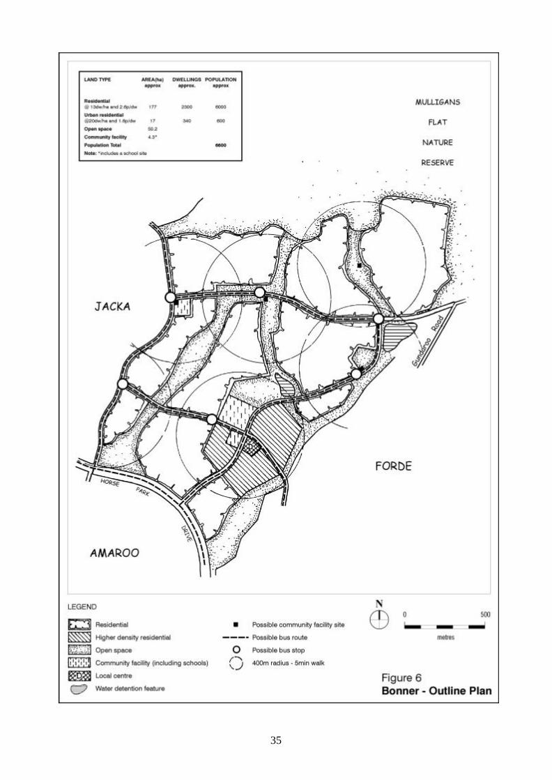
35
36
Jacka This is a relatively large, physically complex and interesting suburb located centrally within the Structure Plan area, and focuses on the Horse Park Wetlands and heritage precinct. GENERAL POLICIES (Refer to Fig. 7) A. The Horse Park Wetlands and heritage precinct is to be protected by inclusion within a
substantial area of Urban Open Space (generally incorporating the curtilage boundaries identified by the Register of the National Estate listing for the wetland) which will be subject to specific planning policies and management practices. The precinct shall have high visibility and ease of access. The wetlands are to be protected by upstream stormwater management techniques.
B. A local centre is to be located in the centre of the suburb incorporating areas of higher
residential density. C. A primary school, neighbourhood oval and district playing fields are to be located
upstream of the wetlands and central to the school catchment. D. Local bus routes to be provided through the suburb, encouraging public transport use. E. Edge roads are to be utilised wherever possible as a buffer between residential
development and areas of open space. An edge road shall be predominantly used as a buffer where the adjoining open space contains substantial cultural heritage or environmental values.
F. To ensure the integrity of water quality and flow to the wetland area, water management
features are to be located upstream. The formation and design of these features will be the subject of further hydraulic studies.
G. Opportunities are to be provided for small-scale community facility sites generally located
in open space in convenient locations predominantly along public transport routes. H. Provide an area close to the local centre for a possible community facility site. I. Provide for an urban edge trail (equestrian and other uses) that will move incrementally as
the urban edge develops. SPECIFIC POLICIES (Refer to Figs.7 and 8) 1. A hilltop reserve lookout is to be located on the major spur of higher country to the west of
wetlands area. This spur is to connect back to the permanent non-urban land to the north via open space.
2. Cultural natural and/or heritage sites are to be preserved within open space. 3. Existing drainage lines are to contribute to a linear park system. 4. Significant hilltops and ridges are to be retained in urban open space. 5. An area of higher density housing is to be provided adjacent to Amaroo Group Centre.
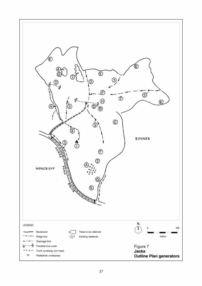
37
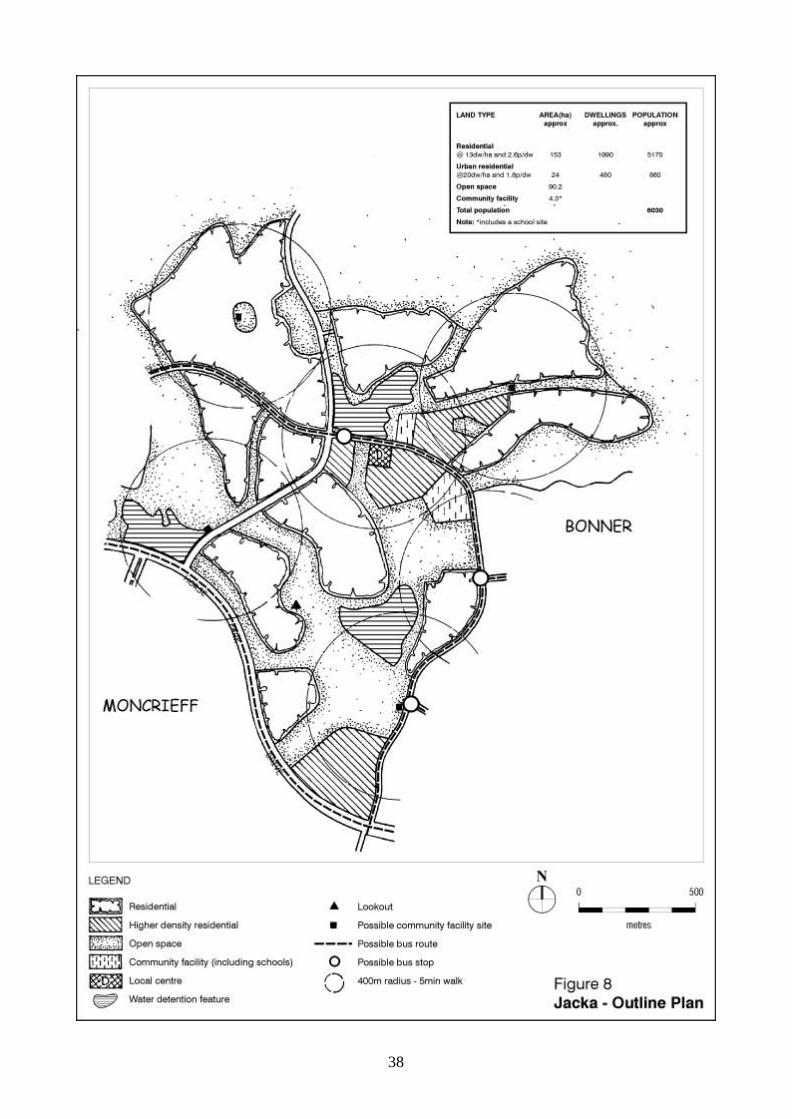
38
39
Moncrieff This is a relatively small suburb, essentially made up of three hills and defined around its north, eastern and western boundaries by Horse Park Drive and is located north of the existing suburbs of Ngunnawal and Amaroo. The suburb is to be developed to provide a strong sense of local identity, achieved by creating hilltop parks. GENERAL POLICIES ( Refer to Fig.9) A. A group centre and higher density housing at the intersection of Horse Park and Mirrabei
Drives shall be developed, in layout and design, on the principles of an ‘urban village’, closely aligned towards public transport use. Each of the intersecting roads shall be designed as urban boulevards, with at-grade pedestrian crossings. The precinct shall be integrated with the major open space system, directly to the north.
B. Bushland revegetation shall be undertaken on the steeply sloped ridge on the eastern
edge of Moncrieff overlooking the Amaroo District Playing Fields. C. Edge roads are to be utilised wherever possible as a buffer between residential
development and areas of open space. An edge road shall be predominantly used as a buffer where the adjoining open space contains substantial cultural heritage or environmental values.
D. Local bus routes are to be provided through the suburb, encouraging public transport
usage. E. Open space spine is to be based on existing drainage paths. F. Opportunities are to be provided for small-scale community facility sites in open space in
convenient locations predominantly along public transport routes. SPECIFIC POLICIES (Refer to Figs.9 and 10) 1. A site is to be reserved for a potential secondary college adjacent to the group centre. 2. The east-west ridge that connects to a generally north-south avenue to Horse Park Drive is
to be retained and protected. 3. Significant hilltops and ridges are to be retained in urban open space. 4. A trunk cycleway is to be provided along Mirrabei Drive connecting with trunk cycleway on
Horse Park Drive. 5. An Inter-town Public Transport (IPT) route is to be provided along Mirrabei Drive with a
terminus to be located at the group centre. 6. Roads are to be designed as boulevards. 7. The road connection to be designed as an avenue and align with water management
feature as a terminating view.
40
8. No development is to be permitted on eastern escarpment.
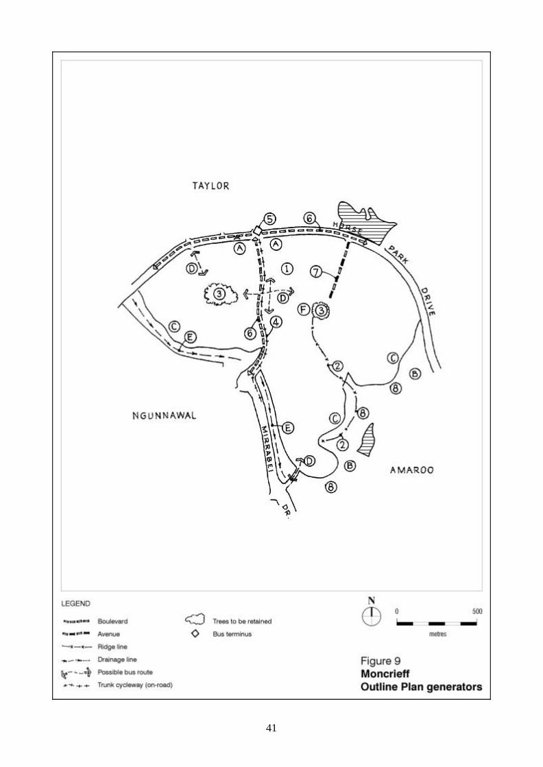
41
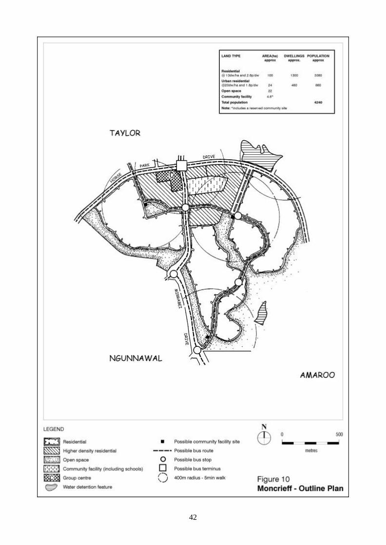
42
43
Taylor A relatively large suburb which provides the highest (Australian Height Datum) residential land in Canberra, is located in the north west corner of North Gungahlin. GENERAL POLICIES (Refer to Fig. 11) A. Two axes are defined which give structure to the area; North-south from the high country
north of Taylor with a line of site to Black Mountain Tower, and east-west from Horse Park Wetland to One Tree Hill. These axes then form the basis for road and open space alignments.
B. A local centre together with adjacent higher density housing is to be centrally located. C. District playing fields and a neighbourhood oval are to be located adjacent to government
primary and high school sites. D. Landscaped floodways interconnect throughout the north of the suburb and terminate at a
landscaped water management feature to the east. E. Local bus routes are to be provided through the suburb, encouraging public transport
usage. F. Edge roads are to be utilised wherever possible as a buffer between residential
development and areas of open space. An edge road shall be predominantly used as a buffer where the adjoining open space contains substantial cultural heritage or environmental values.
G. Opportunities are to be provided for small-scale community facility sites in open space in
convenient locations predominantly along public transport routes. H. Provide an area close to the local centre for a possible community facility site. I. Provide for an urban edge trail (equestrian and other uses) that will move incrementally as
the urban edge develops. SPECIFIC POLICIES (Refer to Fig. 11 and 12) 1. A park is to be located on the hilltop. 2. Heritage site (European heritage - ruins) and adjacent significant trees are to be located
in urban open space. 3. Part of the group centre and higher density housing shall be co-located opposite Moncrieff
at intersection of major roads.
44
45
46
Casey This suburb forms the western edge of North Gungahlin and occupies a relatively narrow strip of land between Horse Park Drive and the treed ridge lines to the west which form the visual backdrops, separating the suburb from Hall and the Kinlyside valley. GENERAL POLICIES (Refer to Fig. 13) A. A group centre with adjoining higher density housing and an open space site is to be
developed in the southeastern corner at the intersection of Horse Park and Clarrie Hermes Drives.
B. A local centre with adjoining higher density housing and an open space site is to be
located to the north of the suburb. C. Edge roads are to be utilised wherever possible as a buffer between residential
development and urban open space. An edge road shall be predominantly used as a buffer where the adjoining open space contains substantial cultural heritage or environmental values.
D. A local bus route is to be provided through the suburb via the local and group centres and
areas of higher density. E. Opportunities are to be provided for small-scale community facility sites in open space in
convenient locations predominantly along public transport routes. F. Provide an area close to the local centre for a possible community facility site. SPECIFIC POLICIES (Refer to Figs.13 and14) 1. A possible road connection to the Kinlyside Valley is to be identified to the north of the
suburb. 2. A neighbourhood playing field to be located within the east-west linear park. 3. A significant stand of trees with high conservation value marking an old north-south road
alignment adjacent to Horse Park Drive is to be protected, retained and managed within the urban open space system. An edge road is to be provided adjacent to the old north-south road alignment and adjacent trees.
4. Stands of trees with high conservation value bisect the suburb and enhance the bushland
character of the resultant open space linkage back to the ridge. This link is to be preserved in the form of an east-west linear park.
47
48
49
Part Ngunnawal (Refer to Fig. 15A) A relatively small area of low-density housing remains to be developed in north west Ngunnawal. A local park protecting existing stands of trees is to be established on the small ridge along the eastern flank of this area. Identify possible site for community facility. Burrumarra Avenue is to be extended through the precinct as the main collector road, providing a direct link to Casey Local Centre. Part Amaroo
(Refer to Fig. 15B) The area comprises the Amaroo Community Precinct and contains a proposed group centre. Development of the group centre shall be in stages and incorporate opportunities for commercial uses, community facilities and higher density residential housing.
50