Embed Size (px)
Citation preview

Vegetation Resources Inventory
The B.C. Land Cover ClassificationScheme
Prepared byMinistry of Sustainable Resource Management
Terrestrial Information Branchfor the Terrestrial Ecosystems Task Force - Vegetation
Resources Inventory Committee
March 29, 2002
Version 1.3

© The Province of British ColumbiaPublished by theResources Inventory Committee
National Library of Canada Cataloguing in Publication Data
Main entry under title:Vegetation resources inventory [electronic resource] : the B.C. land coverclassification scheme – Version 1.3
Previous version published by Ministry of Forests, Resources InventoryBranch.Available on the Internet.Issued also in printed format on demand.Includes bibliographical references: p.ISBN 0-7726-4707-0
1. Vegetation classification - British Columbia.2. Plants – Identification. 3. Plant communities – British Columbia. I.British Columbia. Ministry of Sustainable Resource Management. TerrestrialInformation Branch. II. Resources Inventory Committee (Canada).Terrestrial Ecosystems Task Force. III. Resources Inventory CommitteeCanada). Vegetation Inventory Working Group.
QK203.B7V43 2002 333.95’311’09711 C2002-960025-1
Additional Copies of this publication can be purchased from:
Government Publication ServicesPhone: (250) 387-6409 orToll free: 1-800-663-6105Fax: (250) 387-1120www.publications.gov.bc.ca
Digital Copies are available on the Internet at:http://www.for.gov.bc.ca/ric

BC Land Cover Classification Scheme
March 29, 2002 iii
AcknowledgmentsFunding of the Resources Inventory Committee work, including the preparation of thisdocument, is provided by the Corporate Resource Inventory Initiative (CRII) and by ForestRenewal BC (FRBC). Preliminary work of the Resources Inventory Committee was fundedby the Canada-British Columbia Partnership Agreement of Forest Resource DevelopmentFRDA II.
The Resources Inventory Committee consists of representatives from various ministries andagencies of the Canadian and the British Columbia governments as well as from FirstNations peoples. RIC objectives are to develop a common set of standards and proceduresfor the provincial resources inventories, as recommended by the Forest ResourcesCommission in its report “The Future of our Forests”.
For further information about the Resources Inventory Committee and its various TaskForces, please access the Resources Inventory Committee Website at:http://www.for.gov.bc.ca/ric.
Terrestrial Ecosystems Task ForceThe Vegetation Inventory Working Group was formed in 1993 and issued their final report inMarch 1995 on a “Proposed New Inventory” for British Columbia. The Ministry of Forests,Resources Inventory Branch, in cooperation with the Ministry of Environment, otherMinistry of Forests branches, and consultants, developed the suite of Vegetation ResourcesInventory Procedures based on the recommendations in that report. Many individuals wereinvolved in writing the original version of the various Vegetation Resources InventoryProcedures documents.
For questions concerning the content of this publication please contact the:
Vegetation Resources Inventory Coordinatorc/o Ministry of Sustainable Resource ManagementTerrestrial Information BranchPO Box 9333, 722 Johnson StreetVictoria, BC V8W 9R7
Phone: (250) 387-1314Fax: (250) 387-5999


BC Land Cover Classification Scheme
March 29, 2002 v
Table of ContentsAcknowledgments ....................................................................................................................iii
BC Land Classification System................................................................................................. 1
Introduction ........................................................................................................................... 1
Who will use the information?.......................................................................................... 1
Classifying Land Cover......................................................................................................... 2
Polygon Attribute - The Information Source for the Cover Designation.......................... 2
The Coding System........................................................................................................... 3
Level 1 - Classifying the Land Base ..................................................................................... 6
Classifying Vegetated Polygons............................................................................................ 6
Level 2 - Land Cover Type ............................................................................................... 6
Level 3 - Landscape Position ............................................................................................ 7
Level 4 - Vegetation Type................................................................................................. 7
Level 5 - Density Class ..................................................................................................... 9
Classifying Non-Vegetated Polygons ................................................................................. 10
Level 2 - Land Cover Type ............................................................................................. 10
Classifying Non-Vegetated Land Polygons ........................................................................ 10
Level 3 - Landscape Position (Land) .............................................................................. 10
Level 4 - Non-Vegetated Cover Type (Land) ................................................................. 11
Level 5 - Non-Vegetated Categories (Land) ................................................................... 11
Classifying Non-Vegetated Water Polygons....................................................................... 13
Level 3 - Landscape Position (Water)............................................................................. 13
Level 4 - No Level 4 for Water ....................................................................................... 14
Level 5 - Water Categories ............................................................................................. 14
Literature Cited ....................................................................................................................... 15
Appendix A - Land Cover Classification Criteria................................................................... 17
Appendix B - Definitions ........................................................................................................ 18
Vegetated Land Definitions ............................................................................................ 18
Non-Vegetated Land Definitions .................................................................................... 19
Wetland Definitions ........................................................................................................ 21

BC Land Cover Classification Scheme
vi March 29, 2002
Appendix C - The B.C. Tree Code List ...................................................................................23
Appendix D - Low Woody Species and Intermediate Life Forms ..........................................27
Appendix E - Discussion of the B.C. Land Classification Scheme.........................................30
Index ........................................................................................................................................35
List of FiguresFigure 1 - Structure of the B.C. Land Cover Classification Scheme - Vegetated polygons......4
Figure 2 - Structure of the B.C. Land Cover Classification Scheme - Non-Vegetated polygons...........................................................................................................................................5

BC Land Cover Classification Scheme
March 29, 2002 1
BC Land Classification System
IntroductionThe Vegetation Inventory Working Group, a component of the Resources InventoryCommittee (RIC), was given the task of creating a land cover classification system to meetthe needs of British Columbia’s resource managers today and in the future. Present inventorysystems were found to be inadequate when used to assess integrated resource managementoptions. It was from this perspective, along with growing world-wide demand for an accurateassessment of land cover, that the classification scheme was created.
The B.C. Land Cover Classification Scheme was designed to meet present provincial andnational needs, and to be capable of providing data for global vegetation accounting asproposed by Bones (1993) for the Forest Resources Division of the Food and AgricultureOrganization of the United Nations (FAO). In designing the B.C. system, the working groupexamined a number of classification systems, including Dansereau 1957, Küchler 1967,Fosberg 1967, Ellenberg and Mueller-Dombois 1967 (UNESCO), Ellenberg 1973, NationalVegetation Working Group 1990, Viereck et al. 1992, Alberta Forestry, Lands and Wildlife1992, and Bones 1993. The intent was to make a useful functional system for B.C. whileretaining compatibility with other systems. The new classification will take the place of theold timber-based inventory system.
The B.C. Land Cover Classification Scheme meets all 12 criteria suggested by Bones (1993)for international standard forest definitions and classifications (see Appendix A for a list ofthe 12 criteria). The B.C. system embraces the first criteria that the classification be based oncurrent cover (vegetated or non-vegetated), not on climax or potential cover. As well, therevised system has no culturally biased terms such as the old term “non-productive brush.”This provides an unbiased assessment of what exists at the time of the inventory, not whatpotentially could exist. Beyond the classification levels, additional attributes can be specifiedto provide more information on a described unit. For example, the plant association found onthe site or the silvicultural treatments done on that unit can be described.
This manual describes the various steps and levels in the classification system. A schematicof the classification is shown in Figures 1 and 2 to help visualize the entire system. AppendixB provides definitions of all classes used. Appendix E provides a comparison of the B.C.Scheme with other systems.
Who will use the information?The B.C. classification system will be used as a baseline for resource managers when makingintegrated resource management decisions. For example, information will be available towildlife managers on the extent of various vegetation communities, such as the location ofareas covered by browse species. Hydrologists will have access to information on vegetationcover relating to hydrological green-up on a drainage-by-drainage basis. Range managerswill be able to assess the extent of grass- and herb-dominated sites when determining rangeoptions. Timber managers will be provided with an assessment of the timber resource,including all of the present information and additional details on adjacent land cover. The
BC Land Cover Classification Scheme
2 March 29, 2002
classification will also provide snapshots of land cover that can be used as benchmarks fortracking global and local changes.
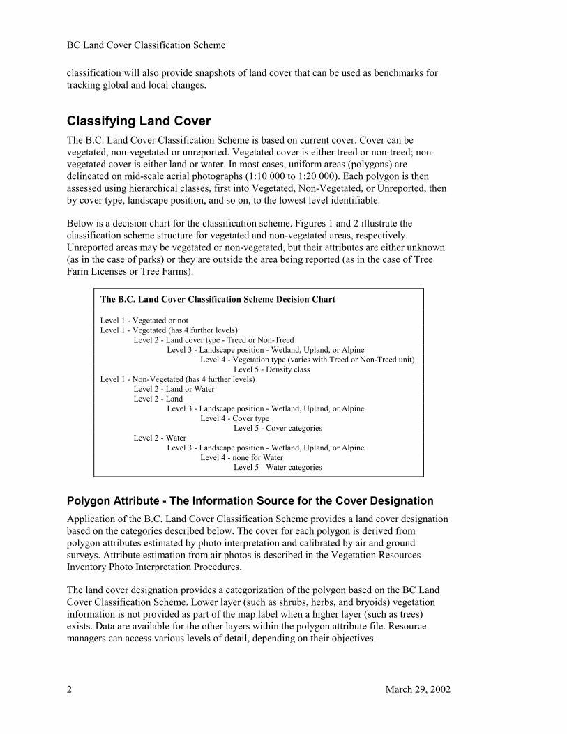
Classifying Land CoverThe B.C. Land Cover Classification Scheme is based on current cover. Cover can bevegetated, non-vegetated or unreported. Vegetated cover is either treed or non-treed; non-vegetated cover is either land or water. In most cases, uniform areas (polygons) aredelineated on mid-scale aerial photographs (1:10 000 to 1:20 000). Each polygon is thenassessed using hierarchical classes, first into Vegetated, Non-Vegetated, or Unreported, thenby cover type, landscape position, and so on, to the lowest level identifiable.
Below is a decision chart for the classification scheme. Figures 1 and 2 illustrate theclassification scheme structure for vegetated and non-vegetated areas, respectively.Unreported areas may be vegetated or non-vegetated, but their attributes are either unknown(as in the case of parks) or they are outside the area being reported (as in the case of TreeFarm Licenses or Tree Farms).
The B.C. Land Cover Classification Scheme Decision Chart
Level 1 - Vegetated or notLevel 1 - Vegetated (has 4 further levels)
Level 2 - Land cover type - Treed or Non-TreedLevel 3 - Landscape position - Wetland, Upland, or Alpine
Level 4 - Vegetation type (varies with Treed or Non-Treed unit)Level 5 - Density class
Level 1 - Non-Vegetated (has 4 further levels)Level 2 - Land or WaterLevel 2 - Land
Level 3 - Landscape position - Wetland, Upland, or AlpineLevel 4 - Cover type
Level 5 - Cover categoriesLevel 2 - Water
Level 3 - Landscape position - Wetland, Upland, or AlpineLevel 4 - none for Water
Level 5 - Water categories
Polygon Attribute - The Information Source for the Cover DesignationApplication of the B.C. Land Cover Classification Scheme provides a land cover designationbased on the categories described below. The cover for each polygon is derived frompolygon attributes estimated by photo interpretation and calibrated by air and groundsurveys. Attribute estimation from air photos is described in the Vegetation ResourcesInventory Photo Interpretation Procedures.
The land cover designation provides a categorization of the polygon based on the BC LandCover Classification Scheme. Lower layer (such as shrubs, herbs, and bryoids) vegetationinformation is not provided as part of the map label when a higher layer (such as trees)exists. Data are available for the other layers within the polygon attribute file. Resourcemanagers can access various levels of detail, depending on their objectives.

BC Land Cover Classification Scheme
March 29, 2002 3
The Coding SystemThe land classification of each polygon is summarized as a seven-letter code to facilitatebroad land classification reporting. The classification scheme also provides the criteria fordistinguishing cover types within the polygon. These criteria are critical for assessingspecific tree, shrub, herbaceous, bryoid, and non-vegetated communities within polygonboundaries (referred to as land cover components). Code letters are given in the detaileddescriptions that follow.
The following is an example of the derivation of the seven-letter Land Cover Class Code:
Level Estimated attributes Code assigned
1 Vegetated crown closure �5% V (Vegetated)2 Tree crown closure �10% T (Treed)3 Not Wetland U (Upland)4 Coniferous �75% of total Crown Closure TC (Treed-Coniferous)5 Tree crown closure = 80% DE (Dense)
The Land Cover Class Code for this polygon would be VTUTCDE.

BC Land Cover Classification Scheme
4 March 29, 2002
Figure 1 - Structure of the B.C. Land Cover Classification Scheme - Vegetatedpolygons
Vegetated
Upland
Upland
Alpine
Coniferous
Broadleaf
Mixed
Wetland
Wetland
Open
Vegetated Polygons
LEVEL 1Land Base
LEVEL 2Land Cover Type
LEVEL 3Landscape Position
LEVEL 4Vegetated Types
LEVEL 5Density Classes
Non-treed
Treed
Sparse
Dense
OpenSparse
Dense
OpenSparse
Dense
Coniferous
Broadleaf
Mixed
OpenSparse
Dense
OpenSparse
Dense
OpenSparse
Dense
Shrub Tall
Shrub Low
Bryoid
OpenSparse
Dense
OpenSparse
Dense
same as Shrub Tall
Herb same as Shrub Tall
same as Non-Treed Wetland
Shrub Tall
Shrub Low
Bryoid
OpenSparse
Dense
OpenClosed
same as Shrub Tall
Herb same as Shrub Tall

BC Land Cover Classification Scheme
March 29, 2002 5
Figure 2 - Structure of the B.C. Land Cover Classification Scheme - Non-Vegetatedpolygons
Non-Vegetated
Upland
Alpine
Upland
Alpine
Snow / Ice
Rock / Rubble
Exposed Land
Wetland
Detailed description
Detailed description
Detailed description
Wetland
Snow / Ice
Rock / Rubble
Exposed Land
Detailed description
Detailed description
Detailed description
Snow / Ice
Rock / Rubble
Exposed Land
Detailed description
Detailed description
Detailed description
Detailed description
Detailed description
Detailed description
Non-Vegetated Polygons
LEVEL 1Land Base
LEVEL 2Land Cover Type
LEVEL 3Landscape Position
LEVEL 4Non-VegetatedCover Types
LEVEL 5Non-VegetatedCategories
Water
Land

BC Land Cover Classification Scheme
6 March 29, 2002
Level 1 - Classifying the Land BaseThe first level of the classification scheme classifies the presence or absence of vegetation,as Vegetated, Non-Vegetated, or Unreported.
V = VegetatedA polygon is considered Vegetated when the total cover of trees, shrubs, herbs,and bryoids (other than crustose lichens) covers at least 5% of the total surfacearea of the polygon.
N = Non-VegetatedA polygon is considered Non-Vegetated when the total cover of trees, shrubs,herbs, and bryoids covers less than 5% of the total surface area of the polygon.Bodies of water are to be classified as Non-Vegetated.
U = UnreportedA polygon is classified as Unreported if it is within the mapsheet being reportedon, but is outside the inventory unit of interest. The Unreported designation isrestricted to areas where inventory information is not currently available.Examples include National Parks, Provincial Parks (where information is notavailable), Tree Farm Licences and Tree Farms that are not in the existingvegetation cover databases, and areas outside of the Province of British Columbia.
Classifying Vegetated PolygonsIf the polygon is classed as Vegetated the following levels apply.(If classified as Non-Vegetated see Classifying Non-Vegetated Polygons for a description offurther levels.)
Level 2 - Land Cover TypeThe first determination for Vegetated polygons is whether they are Treed or Non-Treed.
T = TreedA polygon is considered Treed if at least 10% of the polygon area, by crown cover,consists of tree species of any size. See Appendix C for a list of tree species forB.C.
N = Non-TreedA polygon is considered Non-Treed if less than 10%, by crown cover, of thepolygon area consists of tree species of any size.
Note: Tree species less than 10 m high are not classed as shrubs (as they are in ecologicalsurveys).

BC Land Cover Classification Scheme
March 29, 2002 7
Level 3 - Landscape PositionOnce the polygon has been classified into Treed or Non-Treed, the location relative toelevation and drainage is determined.
W = WetlandWetland has numerous definitions in the literature. The definition used for theclassification is taken from Fraser et al. (1995):
Wetland is defined as land having the water table at, near or above the soil surfacethat remains saturated for a long enough period of time to promote wetland oraquatic processes. These processes are indicated by the presence of Organic orGleysolic soils and hydrophytic vegetation. See Appendix B for a more completedefinition of Wetland.
U = UplandA broad class that includes all non-wetland ecosystems below Alpine that rangefrom very xeric to hygric soil moisture regimes.
A = AlpineTreeless (for practical purposes less than 1% tree cover can be included within theAlpine category), with vegetation dominated by shrubs, herbs, graminoids,bryoids, and lichens. Much of the Alpine is dominated by rock, ice, and snow.Alpine does not typically include the parkland and krummholz forest types. Alpineis a classification level of Non-Treed areas above the tree line only.
Level 4 - Vegetation TypeOnce the polygon is classed as Treed or Non-Treed and determined whether it is Wetland,Upland, or Alpine, it is further classified by the type of vegetation within the unit:
Vegetated Treed
Treed units can be either Coniferous, Broadleaf, or Mixed.
TC = Treed – Coniferous Defined as those trees found in B.C. within the order Coniferae. These species arecommonly referred to as conifer or softwoods. See Appendix C for a list of B.C.species and species codes.
The polygon is classified as Coniferous when trees cover a minimum of 10% of thetotal polygon area by crown cover, and coniferous trees are 75% or more of thetotal tree basal area.

BC Land Cover Classification Scheme
8 March 29, 2002
TB = Treed - BroadleafDefined as those trees classified botanically as Angiospermae in the subclassDicotyledoneae. These species are commonly referred to as deciduous orhardwoods. See Appendix C for a list of B.C. species and species codes.
The polygon is classified as Broadleaf when trees cover a minimum of 10% of thetotal polygon area by crown cover, and broadleaf trees are 75% or more of the totaltree basal area.
TM = Treed – MixedThe polygon is classified as Mixed when trees cover a minimum of 10% of thetotal polygon area by crown cover, but neither coniferous nor broadleaf treesaccount for 75% or more of the total tree basal area.
Vegetated Non-Treed UnitsNon-Treed units can be either Shrub, Herb, or Bryoid.
Non-Treed Shrub
Shrubs are defined as multi-stemmed woody perennial plants, both evergreen and deciduous.A reporting break is made between Tall (greater than or equal to 2 m) and Low (less than2 m) for wildlife management interpretation purposes. Other breaks may be used if preferred,as height data are estimated as a continuous variable.
For a polygon to be classed as Non-Treed Shrub, it must have more than 5% total vegetationcover, have less than 10% of crown cover of trees, and have a minimum of 20% groundcover of shrubs, or shrubs must constitute more than 1/3 of the total vegetation cover.
ST = Shrub Tall A Shrub polygon with average height greater than or equal to 2 m.
SL = Shrub LowA Shrub polygon with average shrub height less than 2 m.
Non-Treed Herb
Herbs are defined, for this system, as vascular plants without a woody stem, including ferns,fern allies, some dwarf woody plants, grasses, and grass-like plants. See Appendix D for alist of low woody species and species of doubtful life form assigned for this classification tothe herb layer.
The Herb class has two further subdivisions based on the proportion of forbs and graminoidplants. The subclasses Forbs and Graminoids are used when any one group accounts forgreater than 50% of the herb cover.
Graminoids are defined as herbaceous plants with long, narrow leaves characterized bylinear venation; including grasses, sedges, rushes, and other related species.
Forbs are defined as herbaceous plants other than graminoids, including ferns, clubmosses,and horsetails.

BC Land Cover Classification Scheme
March 29, 2002 9
For a polygon to be classed as Non-Treed Herb it must have more than 5% total vegetationcover, have less than 10% crown cover of trees, and have a minimum of 20% ground coverof herbs, or herbs must constitute more than 1/3 of the total vegetation cover, and have lessthan 20% shrub cover.
HE = Herb A Herb polygon with no distinction between forbs and graminoids.
HF = Herb – ForbsA Herb polygon with forbs greater than 50% of the herb cover.
HG = Herb – Graminoids A Herb polygon with graminoids greater than 50% of the herb cover.
Non-Treed Bryoid
Bryoids are defined as bryophytes (mosses, liverworts, and hornworts) and lichens (folioseor fruticose; not crustose).
For a polygon to be classed Non-Treed Bryoid it must have more than 5% total vegetationcover, have less than 10% crown cover of trees, and have greater than 50% of the vegetationcover in bryoids, and herb and shrub cover must each be less than 20% crown cover.
The Bryoid class has two further subdivisions based on the proportion of bryophytes andlichens. The class is subdivided into Bryophyte or Lichen when any one group accounts forgreater than 50% of the bryoid cover.
BY = Bryoids A Bryoid polygon with no distinction between mosses and lichens by cover.
BM = Bryoid – MossA Bryoid polygon with mosses, liverworts, and hornworts greater than 50% of thebryoid cover.
BL = Bryoid – LichensA Bryoid polygon with lichens (foliose or fruticose; not crustose) greater than 50%of the bryoid cover.
Level 5 - Density ClassOnce a Vegetated polygon is classed up to Level 4, density is reported using the followingdensity classes available by vegetation type. Note that these are reporting breaks only;interpreters will estimate density in a continuous manner (from 0% to 100%).
The density classes for Treed, Shrub, or Herb polygons are as follows:
DE = DenseTree, shrub, or herb cover is between 61% and 100% crown closure for thepolygon.

BC Land Cover Classification Scheme
10 March 29, 2002
OP = OpenTree, shrub, or herb cover is between 26% and 60% crown closure for the polygon.
SP = SparseTree cover is between 10% and 25% for Treed polygons, or between 20% and 25%for Shrub or Herb polygons.
The density classes for Bryoid polygons are as follows:
CL = ClosedCover of bryoids is greater than 50% of the polygon.
OP = OpenCover of bryoids is less than or equal to 50% of the polygon.
Classifying Non-Vegetated PolygonsA polygon is considered Non-Vegetated when the total cover of trees, shrubs, herbs, andbryoids covers less than 5% of the total surface area of the polygon.
Level 2 - Land Cover TypeThe first decision is whether a polygon is considered to be Land or a Water body. The covertype occupying greater than 50% of the polygon area is the cover type assigned.
L = LandThe portion of the landscape not covered by water (as defined below), based on thepercentage cover area.
W = WaterA naturally occurring, static body of water, two or more metres deep in someportion, or a watercourse formed when water flows between continuous, definablebanks. These flows may be intermittent or perennial; but do not include ephemeralflows where a channel with no definable banks is present. Islands within streamsthat have definable banks are not part of the stream; gravel bars are part of thestream. Interpretation is based on the percentage area covered.
Classifying Non-Vegetated Land PolygonsIf the polygon is classed as Land the following steps and levels apply.(If classed as Water see Land Cover Type - Water for a description of further levels.)
Level 3 - Landscape Position (Land)This level describes the location of the polygon relative to elevation and drainage, and isdescribed as Wetland, Upland, or Alpine. In rare cases, the polygon may be Alpine Wetland.
W = WetlandLand having a water table near, at, or above the soil surface, or which is saturated

BC Land Cover Classification Scheme
March 29, 2002 11
for a long enough period to promote wetland or aquatic processes. These processesare indicated by the presence of Organic or Gleysolic soils and hydrophyticvegetation. See Appendix B for a more complete definition of Wetland.
U = UplandA broad class that includes all non-wetland ecosystems below alpine that rangefrom very xeric to hygric soil moisture regimes.
A = AlpineTreeless (for practical purposes less than 1% tree cover can be included within theAlpine category), with vegetation dominated by shrubs, herbs, graminoids,bryoids, and lichens. Much of the Alpine is dominated by rock, ice, and snow.Alpine does not typically include the parkland and krummholz forest types. Alpineis a classification of Non-Treed areas above the tree line only.
Level 4 - Non-Vegetated Cover Type (Land)Once the polygon is classed as Non-Vegetated and determined whether it is Wetland,Upland, or Alpine, it is further classified by the type of non-vegetated condition within theunit. Non-Vegetated polygons are divided into three groups: Snow/Ice, Rock/Rubble, andExposed Land.
SI = Snow/IceDefined as either glacier or snow cover.
RO = Rock/RubbleDefined as bedrock or fragmented rock broken away from bedrock surfaces andmoved into its present position by gravity or ice. Extensive deposits are found inand adjacent to alpine areas and are associated with steep rock walls and exposedridges; canyons and cliff areas also contain these deposits.
EL = Exposed LandContains all other forms of Exposed Land identified by a range of subclasses.
Level 5 - Non-Vegetated Categories (Land)Classes are defined by the dominant material or feature of the non-vegetated area.
Snow/Ice has two subclasses - Glacier and Snow Cover:
GL = GlacierA mass of perennial snow and ice with definite lateral limits, typically flowing in aparticular direction.
PN = Snow CoverSnow or ice that is not part of a glacier, but is found during summer months on thelandscape.
Rock/Rubble has four subclasses:

BC Land Cover Classification Scheme
12 March 29, 2002
BR = BedrockUnfragmented, consolidated rock contiguous with the underlying material.
TA = TalusRock fragments of any size accumulated on or at the foot of slopes as a result ofsuccessive rock falls. This is a type of colluvium.
BI = BlockfieldBlocks of rock derived from the underlying bedrock by weathering and / or frostheaving. These have not undergone any significant down slope movement as theyoccur on level or gently sloping areas.
MZ = Rubbly Mine SpoilsDiscarded overburden or waste rock moved to extract ore during a miningoperation.
LB = Lava BedAn area where molten rock has flowed from a volcano or fissure and cooled andsolidified to form rock.
Exposed Land has 18 subclasses:
RS = River SedimentsSilt, gravel, and sand bars associated with former river channels and present riveredges.
ES = Exposed SoilAny exposed soil not covered by the other categories, such as areas of recentdisturbance including mud slides, debris torrents, avalanches, or disturbances suchas pipeline rights-of-way or cultivated fields, where vegetation cover is less than5%.
LS = Pond or Lake SedimentsExposed sediments related to dried-up lakes or ponds.
RM = Reservoir MarginLand exposed by a drained or fluctuating reservoir. It is found above “normal”water levels and may consist of a range of substrates including gravel, cobbles,fine sediments, or bedrock.
BE = BeachAn area with sorted sediments reworked in recent time by wave action. It may beformed at the edge of fresh or salt water bodies.
LL = LandingA compacted area adjacent to a road used for sorting and loading logs.
BU = Burned AreaLand showing evidence of recent burning, either natural or prescribed. Vegetationof less than 5% crown cover is present at the time of polygon description.

BC Land Cover Classification Scheme
March 29, 2002 13
RZ = Road SurfaceAn area cleared and compacted for transporting goods and services by vehicles.Older roads that are used infrequently or not at all may cease to be classified asnon-vegetated.
MU = Mudflat SedimentFlat plain-like areas associated with lakes, ponds, rivers, or streams — dominatedby fine-textured sediments, they can be associated with freshwater or estuarinesources.
CB = CutbankPart of a road corridor created upslope of the road surface by excavation into thehillside.
MN = MoraineAn area of debris transported and deposited by a glacier.
GP = Gravel PitAn area exposed through the removal of sand and gravel.
TZ = TailingsAn area containing the solid waste material produced by the mining and milling ofore.
RN = Railway SurfaceA roadbed with fixed rails, may contain single or multiple rail lines.
UR = UrbanBuildings and associated developments such as roads and parking areas whichform an almost continuous covering of the lanscape.
AP = AirportA permanent, paved or gravel area, and associated buildings and parking, used byairplanes.
MI = Open Pit MineAn exposed area used to extract ore during a mining operation. This may containassociated buildings and any tailing produced by the mining and milling process.
OT = OtherA Non-Vegetated polygon where none of the above categories can be reliablychosen.
Classifying Non-Vegetated Water PolygonsIf the polygon is classed as Water the following categories apply:
Level 3 - Landscape Position (Water)The landscape position relative to elevation and drainage is determined.

BC Land Cover Classification Scheme
14 March 29, 2002
W = WetlandLand having a water table near, at, or above the soil surface, which is saturated fora long enough period to promote wetland or aquatic processes. These wetlandprocesses are indicated by the presence of Organic or Gleysolic soils andhydrophytic vegetation. See Appendix B for a more complete definition ofWetland.
U = UplandA broad class that includes all non-wetland ecosystems below alpine that rangefrom very xeric to hygric soil moisture regimes.
A = AlpineTreeless (for practical purposes less than 1% tree cover can be included within theAlpine category), with vegetation dominated by shrubs, herbs, graminoids,bryoids, and lichens. Much of the Alpine is dominated by rock, ice, and snow.Alpine does not typically include the parkland and krummholz forest types. Alpineis a classification of Non-Treed areas above the tree line only.
Level 4 - No Level 4 for WaterThere are no classes at this level (Land Cover Type) for Water.
Level 5 - Water CategoriesFour categories have been identified: Lake, Reservoir, River/Stream, and Salt Water.
LA = LakeA naturally occurring static body of water more than two metres deep in someportion. The boundary for the lake is the natural high water mark.
RE = ReservoirAn artificial basin affected by impoundment behind a human fabricated structuresuch as a dam, berm, dyke, or wall.
RI = River/StreamA watercourse formed when water flows between continuous, definable banks.Flow may be intermittent or perennial, but does not include ephemeral flow wherea channel with no definable banks is present. Gravel bars are part of a stream,while islands within a stream that have definable banks are not.
OC = OceanA naturally occurring body of water containing salt or generally considered to besalty.

BC Land Cover Classification Scheme
March 29, 2002 15
Literature CitedAlberta Forestry, Lands and Wildlife. 1992. Alberta vegetation inventory standards manual.
Land Information Services Division, Resource Information Branch. Mimeo. June 1992.
Bones, J. T. 1993. Report for consultancy on forest definitions and classifications to beemployed for global forest resources assessment, 2000. Pp 175-194 in A. Nyyssönen(ed.), Proceedings of FAO/ECE meeting of experts on global forest resources assessmentin cooperation with UNEP and with the support of FINNIDA (Kotka II). The FinnishForest Research Institute. Research Papers 469. Helsinki, Finland.
British Columbia Ministry of Forests. 1996. Vegetation Resources Inventory PhotoInterpretation Procedures. Inventory Branch, Victoria, BC. Updated 1999.
Cowardin, L.M., V. Carter, F.C. Golet, and E.T. LaRoe. 1979. Classification of wetlands anddeepwater habitats of the United States. U.S. Fish and Wildlife Service, Washington, DC.FWS/OBS-79/31.
Dansereau, P. L. 1957. Biogeography: An ecological perspective. The Ronald Press, NewYork, NY.
Ellenberg, H. 1973. Die Ökosysteme der Erde: Versuch einer Klassifikation der Ökosystemenach funktionalen Gesichtspunkten. Pp. 235-265 in H. Ellenberg (ed.),Ökosystemforschung. Springer-Verlag, Berlin, Heidelberg and New York.
Ellenberg, H, and D. Mueller-Dombois. 1967. Tentative physiognomic-ecologicalclassification of plant formations of the earth. UNESCO Report SC/WS/269 Paris, 26 p.Finalized UNESCO publication 1973. International classification and mapping ofvegetation. Ecology and Conservation Series No. 6.
Fosberg, F.R. 1967. A classification of vegetation for general purposes. Pp. 73-120 in G.F.Peterken, Guide to the check sheet for IBP areas. IBP Handbook No. 4. BlackwellScientific Publications, Oxford and Edinburgh.
Fraser, D.F., A. Banner, and A. Harcombe. 1995. A framework for ecological classificationin British Columbia (V. 13 - February 20 1995) Draft report for the Aquatic andTerrestrial Task Force of RIC, Victoria, BC.
Küchler, A. W. 1967. Vegetation mapping. Ronald Press, New York, NY.
Luttmerding, H.A., D.A Demarchi, E.C. Lea, D.V. Meidinger, and T. Vold. 1990. Describingecosystems in the field. 2nd ed. BC Min. Environ., Lands and Parks. MOE Manual 11,Victoria, BC.
National Vegetation Working Group. 1990. The Canadian vegetation classification system.Canada Committee on Ecological Land Classification. W. L. Strong, E. T. Oswald, and D.J. Downing (eds.). Ecological Land Classification Series, No. 25, SustainableDevelopment, Corporate Policy Group, Environment Canada, Ottawa, ON.

BC Land Cover Classification Scheme
16 March 29, 2002
The Nature Conservancy. 1994. NBS/NPS Vegetation mapping program, standardizednational vegetation classification system (final draft). Environment Systems ResearchInstitute, Redlands, CA.
Viereck, L. A., C. T. Dyrness, A. R. Batten, and K. J. Wenzlick. 1992. The AlaskaVegetation Classification. U.S. Department of Agriculture, Forest Service, Pac. NW Res.Sta., Portland, OR. Gen. Tech. Rep. PNW-GTR-286.

BC Land Cover Classification Scheme
March 29, 2002 17
Appendix A - Land Cover ClassificationCriteriaThe following criteria for developing international standard forest definitions andclassifications are from Bones 1993, p 176:
1. Base the system on current vegetative cover, not climax or potential.
2. Classification should be universally applicable.
3. Optimize, to the extent possible, compatibility with other regional or national landcover/land use systems.
4. Classification should be hierarchically designed (i.e., aggregatable, disaggregatable).
5. The system should be organized from the general to the specific (top down).
6. The system should be designed to take advantage of emerging technologies (e.g.,digital satellite classification) using a vertical projection downward.
7. All categories and life forms (i.e., grass, shrubs, trees) must be accurately defined.
8. Classification must be repeatable from place to place (spatial) and from time to time(temporal).
9. Categories must be mutually exclusive and additive to 100% of the area.
10. The system should set minimum standards for percentage cover (based on vegetationstructure, not species).
11. When possible, definitions should use standard (not scientific) terminology (i.e., termsare understandable, simple, and unbiased in meaning).
12. The system should correspond to identified use and needs.

BC Land Cover Classification Scheme
18 March 29, 2002
Appendix B - DefinitionsThe following terms are defined for use in the B.C. Land Cover Classification Scheme.
Vegetated Land DefinitionsAlpine: Treeless (for practical purposes less than 1% tree cover can be included within theAlpine category), with vegetation dominated by shrubs, herbs, graminoids, bryoids, andlichens. Much of the Alpine is dominated by rock, ice, and snow. Alpine does not typicallyinclude the parkland and krummholz forest types. Alpine is a classification level of Non-Treed areas above the tree line only.
Broadleaf: trees classified botanically as Angiospermae in the subclass Dicotyledoneae(Bones 1993). These species are referred to as hardwoods. For a listing of the species andspecies codes see Appendix C.
Bryoids: are defined as bryophytes (mosses, liverworts, and hornworts) and lichens (folioseor fruticose; not crustose).
Coniferous: trees classified botanically as Coniferae; cone-bearing trees having needles orscale-like leaves, usually evergreen. These species are commonly referred to as softwoods.For a listing of the B.C. species and species codes see Appendix C.
A polygon is classified as Coniferous when trees cover a minimum of 10% of the totalpolygon area by crown cover, and coniferous trees are 75% or more of the total tree basalarea.
Forbs are defined as herbaceous plants other than graminoids, including ferns, clubmosses,and horsetails.
Graminoids are defined as herbaceous plants with long, narrow leaves characterized bylinear venation; including grasses, sedges, rushes, and other related species.
Herbs: vascular plants without a woody stem, including ferns, fern allies (NationalVegetation Working Group 1990), some dwarf woody plants (Luttmerding et al. 1990),grasses, and grass-like plants. See Appendix D for a list of low woody species and species ofdoubful life form assigned, for this classification, to the herb layer.
Krummholz: scrubby, stunted growth form of trees, often forming a characteristic zone atthe limit of tree growth at high elevations.
Non-Treed: a polygon is considered Non-Treed if less than 10%, by crown cover, of thepolygon area consists of tree species of any size.
Parkland: landscape characterized by strong clumping of trees due to environmental factors.
Shrubs: multi-stemmed woody perennial plants, both evergreen and deciduous. A reportingbreak is made between Tall (2 m or more) and Low (less than 2 m) for wildlife management

BC Land Cover Classification Scheme
March 29, 2002 19
interpretation purposes. Other breaks may be made, as height data are estimated as acontinuous variable.
Treed: a polygon is considered Treed if 10% or more of the polygon area, by crown cover,consists of tree species of any size. See Appendix C for a list of tree species for B.C.
Upland: a broad class that includes all non-wetland ecosystems below Alpine that rangefrom very xeric to hygric soil moisture regimes.
Vegetated: a polygon is considered Vegetated when the total cover of trees, shrubs, herbs,and bryoids other than crustose lichens covers at least 5% of the total surface area of thepolygon.
Wetland: is defined as land having the water table at, near, or above the soil surface, orwhich is saturated for a long enough period to promote wetland or aquatic processes. Thesewetland processes are indicated by the presence of Organic or Gleysolic soils andhydrophytic vegetation. See Wetland definitions later in this section for a more completedescription.
Non-Vegetated Land DefinitionsAirport (Exposed Land): a permanent, paved or gravel area, and associated buildings andparking, used by airplanes.
Beach (Exposed Land): an area with sorted sediments reworked in recent time by waveaction. It may be formed at the edge of fresh or salt water bodies.
Bedrock (Rock/Rubble): unfragmented, consolidated rock contiguous with the underlyingmaterial.
Burned Area (Exposed Land): land showing evidence of recent burning, either natural orprescribed. Vegetation of less than 5% crown cover is present at the time of polygondescription.
Cutbank (Exposed Land): part of a road corridor created upslope of the road surface byexcavation into the hillside.
Exposed Land: contains all other forms of exposed land identified by a range of 16subclasses: Beach; Buildings and Parking; Burned Area; Cutbank; Exposed Soil; Gravel Pit;Landing; Moraine; Mudflat Sediment; Other; Pond or Lake Sediments; Railway Surface;Reservoir Margin; River Sediments; Road Surface; Tailings.
Exposed Soil (Exposed Land): any exposed soil not covered by the other categories (e.g.,areas of recent disturbance including mud slides, debris torrents, avalanches, or disturbancessuch as pipe line rights-of-way or cultivated fields) where vegetation cover is less than 5%.
Glacier (Snow/Ice): a mass of perennial snow and ice with definite lateral limits, typicallyflowing in a particular direction.
Gravel Pit (Exposed Land): an area exposed through removal of sand and gravel.

BC Land Cover Classification Scheme
20 March 29, 2002
Lake: a naturally occurring static body of water more than two metres deep in some portion.The boundary for the lake is the natural high water mark.
Land: the portion of the landscape not covered by water, based on the percentage area cover.
Landing (Exposed Land): a compacted area adjacent to a road used for sorting and loadinglogs.
Lava Bed: an area where molten rock has flowed from a volcano or fissure and cooled andsolidified to form rock.
Moraine (Exposed Land): an area of debris transported and deposited by a glacier.
Mudflat Sediment (Exposed Land): flat plain-like areas associated with lakes, ponds,rivers, or streams; dominated by fine-textured sediments. They can be associated withfreshwater or estuarine sources.
Non-Vegetated: A polygon is considered Non-Vegetated when the total cover of trees,shrubs, herbs, and bryoids covers less than 5% of the total surface area of the polygon.Bodies of water are to be classified as Non-Vegetated.
Ocean: a naturally occurring body of water containing salt or generally considered to besalty.
Open Pit Mine (Exposed Land): an exposed area used to extract ore during a miningoperation. This may contain associated buildings and any tailings produced by the miningand milling process.
Other (Exposed Land): a Non-Vegetated polygon where none of the other exposed landcategories can be reliably chosen.
Pond or Lake Sediments (Exposed Land): exposed sediments related to dried-up lakes orponds.
Railway Surface (Exposed Land): a roadbed with fixed rails; may contain single ormultiple rail lines.
Reservoir: an artificial basin affected by impoundment of water behind a human fabricatedstructure such as a dam, berm, dyke, or wall.
Reservoir Margin (Exposed Land): land exposed by a drained or fluctuating reservoir;found above “normal” water levels, and may consist of a range of substrates includinggravel, cobbles, fine sediments, or bedrock.
River/Stream: a watercourse formed when water flows between continuous, definablebanks. Flow may be intermittent or perennial, but does not include ephemeral flow where achannel with no definable banks is present. Gravel bars are part of a stream; islands within astream with definable banks are not.

BC Land Cover Classification Scheme
March 29, 2002 21
River Sediments (Exposed Land): silt, gravel, and sand bars associated with former riverchannels and present river edges.
Road Surface (Exposed Land): an area cleared and compacted for the purpose oftransporting goods and services by vehicles.
Rock/Rubble: bedrock or fragmented rock broken away from the bedrock surface andmoved to its present position by gravity or ice. Extensive deposits are found in and adjacentto alpine areas and are associated with steep rock walls and exposed ridges. Canyons andcliff areas also contain these deposits.
Rubble, Talus, Blockfield (Rock/Rubble): fragmented rock, broken away from the bedrocksurface, and moved to its present position by gravity or ice.
Rubbly Mine Spoils (Rock/Rubble): discarded overburden or waste rock moved to extractore during a mining operation.
Snow Cover (Snow/Ice): snow or ice that is not part of a glacier, but is found duringsummer months on the landscape.
Tailings (Exposed Land): an area containing the solid waste material produced by themining and milling of ore.
Urban (Exposed Land): buildings and associated developments such as roads and parkingareas which form an almost continuous covering of the landscape.
Water: a naturally occurring, static body of water, two or more metres deep in some portion,or a watercourse formed when water flows between continuous, definable banks. Theseflows may be intermittent or perennial; but do not include ephemeral flows where a channelwith no definable banks is present. Islands within a stream with definable banks are not partof the stream; gravel bars are part of the stream. Interpretation is based on the percentagearea covered.
Wetland DefinitionsThis section is taken from Fraser et al. (1995). The wetland classification was under reviewat the time of this report.
Wetland: Land having a water table at, near, or above the soil surface, or which is saturatedfor a long enough period to promote wetland or aquatic processes. Wetland processes areindicated by the presence of Organic or Gleysolic soils and hydrophytic vegetation. Siteswith subhydric soil moisture regime and wetter are generally considered to be wetlands; siteswith deeper waters are aquatic ecosystems. Wetlands must have one of the following fourattributes (adapted from Cowardin et al. 1979):
1. At least periodically, the land supports predominantly hydrophytic plant species.
2. The substrate is predominantly poorly drained subhydric or wetter soil. Soils may beorganic or mineral; in mineral soils, gleying occurs within the top 30 cm.
3. The substrate is nonsoil and is saturated with water covered by shallow water at sometime during the growing season.

BC Land Cover Classification Scheme
22 March 29, 2002
4. A water body less than two metres in depth.
Wetlands can be bogs, swamps, marshes, fens, hotsprings and hotpools, alkali ponds, shrubcarrs, swamps, shallow (less than 2 m) open water, and includes both forested andnonforested ecosystems. As an example, the wetland realm can be subdivided into a numberof classes.
Bogs: a peat-dominated class of wetland. They are wetlands covered or filled with poorly tomoderately decomposed Sphagnum-derived peats. They are nutrient poor. Soils are usuallyFibrisols, Mesisols, or Humisols. In the Fort Nelson Lowlands, bogs can have OrganicCryosolic soils.
Swamps: wooded wetlands dominated by 25% or greater cover of trees or tall shrubs andcharacterized by periodic flooding and nearly permanent subsurface water flow throughvarious mixtures of mineral sediments and peat. Swamps, like fens, are rich in minerals andnutrients, but the characteristic water movement through swamps tends to make them betteraerated than fens. Swamp waters thus have sufficient levels of dissolved oxygen to supporteither tall shrubs or trees.
Marshes: wetlands that are permanently or seasonally inundated with nutrient-rich water,and support extensive cover of emergent herbaceous vegetation rooting in a mineral-richsubstrate. The water level of marshes varies seasonally, and from marsh to marsh. Marshesthat dry by late summer expose matted vegetation and unvegetated mudflats or sandflats, butsaturation persists near the surface. The substrate ranges from dominantly mineral materialsto shallow, well-decomposed peat, derived primarily from marsh vegetation. The substrate isstrongly influenced by water chemistry, which in turn reflects basin geology and regionalclimate.
Fens: wetlands composed of accumulations of well to poorly decomposed, non-sphagnumpeats. Most fens have more than 40 cm of peat accumulation. Fen waters come mostly fromgroundwater and runoff from adjacent mineral uplands. As a result, fens are less acid andmore mineral-rich than are bogs. Fen peat is well to moderately decomposed. Associatedsoils are Mesisols and Humisols. Fen vegetation can be dominated by grasses, sedges, rushes,low shrubs, or trees, and often underlain by mosses.
Wet Meadows: seasonally inundated wetlands, dominated by grasses, sedges, or rushes.They generally occur on mineral soils and have little or no peat accumulation. Tree cover isless than 10%.
Shrub Carrs: wetlands that are seasonally flooded, but dry out at the soil surface during thegrowing season. They occur on mineral soils that are typically gleyed within the top 30 cm.
Shallow Open Water: permanent, shallow (less than 2 m midsummer levels), standingwater that lacks extensive emergent plant cover. Vegetation can be absent or emergent plantscan cover up to 10% of the surface. Shallow Open Waters often include various submergedand floating aquatic macrophytes. Submerged aquatic plants are common. Shallow OpenWater is also found around the edges of many lakes.

BC Land Cover Classification Scheme
March 29, 2002 23
Appendix C - The B.C. Tree Code ListThis section lists the common name, scientific name, and codes for British Columbia trees.Trees are defined as being woody, single stemmed, and capable of growing to greater than10 m in height.
Introduced species not known to occur on Crown Land, but requiring a code for databasepurposes, are indicated with an asterisk *.
From B.C. Tree Code List Version 4.1 - 5 Jan. 1999. Data Custodian: Director, ResearchBranch BC Ministry of Forests.
Common Name Scientific Name Codes
NATIVE CONIFERS
Cedar Thuja Cwestern redcedar Thuja plicata Cw
Cypress Chamaecyparis Yyellow-cedar C. nootkatensis Yc
Douglas-fir Pseudotsuga FDouglas-fir P. menziesii Fd
coastal Douglas-fir P. menziesii var. menziesii Fdc
interior Douglas-fir P. menziesii var. glauca Fdi
Fir (Balsam) Abies Bamabilis fir A. amabilis Ba
grand fir A. grandis Bg
subalpine fir A. lasiocarpa Bl
Hemlock Tsuga Hmountain hemlock T. mertensiana Hm
western hemlock T. heterophylla Hw
mountain x western hemlock hybrid
T. mertensiana x heterophylla Hxm
Juniper Juniperus JRocky Mtn. juniper J. scopulorum Jr
Larch Larix Lalpine larch L. lyallii La
tamarack L. laricina Lt
western larch L. occidentalis Lw
Pine Pinus Pjack pine P. banksiana Pj
limber pine P. flexilis Pf

BC Land Cover Classification Scheme
24 March 29, 2002
Common Name Scientific Name Codeslodgepole pine P. contorta Pl
lodgepole pine P. contorta var. latifolia Pli
lodgepole x jack pine hybrid P. x murraybanksiana Pxj
ponderosa pine P. ponderosa Py
shore pine P. contorta var. contorta Plc
western white pine P. monticola Pw
whitebark pine P. albicaulis Pa
Spruce Picea Sblack spruce P. mariana Sb
Engelmann spruce P. engelmannii Se
Sitka spruce P. sitchensis Ss
white spruce P. glauca Sw
spruce hybrid Picea cross Sx
Engelmann x white P. engelmannii x glauca Sxw
Sitka x white P. x lutzii Sxl
Sitka x unknown hybrid P. sitchensis x ? Sxs
Yew Taxus Twestern yew Taxus brevifolia Tw
NATIVE HARDWOODS
Alder Alnus Dred alder A. rubra Dr
Apple Malus UPacific crab apple Malus fusca Up
Aspen, Cottonwood or Poplar Populus Apoplar P. balsamifera Ac
balsam poplar P. b. ssp. balsamifera Acb
black cottonwood P. b. ssp. trichocarpa Act
hybrid poplars P. spp. Ax
trembling aspen P. tremuloides At
Arbutus Arbutus RArbutus Arbutus menziesii Ra
Birch Betula EAlaska paper birch B. neoalaskana Ea
Alaska x paper birch hybrid B. x winteri Exp
paper birch B. papyrifera Ep
water birch B. occidentalis Ew
Cascara Rhamnus Kcascara R. purshiana Kc

BC Land Cover Classification Scheme
March 29, 2002 25
Common Name Scientific Name Codes
Cherry Prunus Vbitter cherry P. emarginata Vb
choke cherry P. virginiana Vv
pin cherry P. pensylvanica Vp
Dogwood Cornus GPacific dogwood Cornus nuttallii Gp
Maple Acer Mbigleaf maple A. macrophyllum Mb
vine maple A. circinatum Mv
Oak Quercus QGarry oak Q. garryana Qg
Willow Salix spp. WBebb's willow S. bebbiana Wb
Pacific willow S. lucida Wp
peachleaf willow S. amygdaloides Wa
pussy willow S. discolor Wd
Scouler's willow S. scouleriana Ws
Sitka willow S. sitchensis Wt
UNKNOWNS
Unknown XUnknown conifer Xc
Unknown hardwood Xh
OTHERS
Other tree, not on list Z
Other conifer Zc
Other hardwood Zh
EXOTICS
Apple Malus U
apple Malus pumila Ua
Aspen, Cottonwood or Poplar Populus A*southern cottonwood P. deltoides Ad
Birch Betula EEuropean birch B. pendula Ee
silver birch B. pubescens Es
Cherry Prunus Vsweet cherry P. avium Vs
Cypress Chamaecyparis Y*Port Orford-cedar C. lawsoniana Yp

BC Land Cover Classification Scheme
26 March 29, 2002
Common Name Scientific Name Codes
Fir (Balsam) Abies B*balsam fir A. balsamea Bb
noble fir A. procera Bp
*Shasta red fir A. magnifica var. shastensis Bm
*white fir A. concolor Bc
Maple Acer Mbox elder A. negundo Me
*Norway maple A. platanoides Mn
*Sycamore maple A. pseudoplatanus Ms
Other exotics*incense-cedar Calocedrus decurrens Oa
*giant sequoia Sequoiadendron giganteum Ob
*coast redwood Sequoia sempervirens Oc
European mountain-ash Sorbus aucuparia Od
Siberian elm Ulmus pumila Oe
common pear Pyrus communis Of
Oregon ash Fraxinus latifolia Og
Pine Pinus P*Monterey pine P. radiata Pm
*red pine P. resinosa Pr
*sugar pine P. lambertiana Ps
Oak Quercus Q*English oak Q. robur Qe
Spruce Picea S*Norway spruce P. abies Sn

BC Land Cover Classification Scheme
March 29, 2002 27
Appendix D - Low Woody Species andIntermediate Life FormsFrom Habitat Monitoring Committee 1990
Scientific Name Common Name GenusCode
SpeciesCode
Andromeda polifolia bog-rosemary ANDR POL
Anemone multifida cut-leaved anemone ANEM MUL
Apocynum androsaemifolium spreading dogbane APOC AND
Apocynum cannabinum hemp dogbane APOC CAN
Apocynum sibiricum clasping-leaved dogbane APOC SIB
Arctostaphylos alpina alpine bearberry ARCT ALP
Arctostaphylos rubra red bearberry ARCT RUB
Arctostaphylos uva-ursi kinnikinnick ARCT UVA
Aruncus dioicus goatsbeard ARUN DIO
Asclepias ovalifolia oak-leaf milkweed ASCL OVA
Asclepias speciosus showy milkweed ASCL SPE
Cassiope lycopodioides club-moss mountain-heather CASS LYC
Cassiope mertensiana white mountain-heather CASS MER
Cassiope stelleriana Alaskan mountain-heather CASS STE
Cassiope tetragona four-angled mountain-heather CASS TET
Chamaerhodos erecta chamaerhodos CHAM ERE
Chimaphila menziesii Menzies’ pipsissewa CHIM MEN
Chimaphila umbellata prince’s pine CHIM UMB
Comandra umbellata pale comandra COMA UMB
Cornus canadensis bunchberry CORN CAN
Cornus suecica bog bunchberry CORN SUE
Cornus unalaschkensis cordilleran bunchberry CORN UNA
Draba spp. draba DRABA
Dryas drummondii yellow mountain-avens DRYA DRU
Dryas integrifolia entire-leaved mountain-avens DRYA INT
Dryas octopetala white mountain-avens DRYA OCT
Empetrum nigrum crowberry EMPE NIG
Eriogonum androscaceum androscace buckwheat ERIO AND
Eriogonum flavum yellow buckwheat ERIO FLA
Eriogonum heracleoides parsnip-flowered buckwheat ERIO HER
Eriogonum niveum snow buckwheat ERIO NIV

BC Land Cover Classification Scheme
28 March 29, 2002
Scientific Name Common Name GenusCode
SpeciesCode
Eriogonum ovalifolium cushion buckwheat ERIO OVA
Eriogonum pauciflorum few-flowered buckwheat ERIO PAU
Eriogonum umbellatum sulfur buckwheat ERIO UMB
Fragaria chiloensis coastal strawberry FRAG CHI
Fragana vesca wood strawberry FRAG VES
Fragaria virginiana wild strawberry FRAG VIR
Galium boreale northern bedstraw GALI BOR
Gaultheria humifusa alpine wintergreen GAUL HUM
Gaultheria hispidula creeping snowberry GAUL HIS
Gaultheria ovatifolia western tea-berry GAUL OVA
Geocaulon lividum bastard toad-flax GEOC LIV
Kalmia microphylla alpine bog-laurel KALM MIC
Linnaea borealis twinflower LINN BOR
Lithospermum incisum yellow gromwell LITH INC
Lithospermum ruderale lemonweed LITH RUD
Loiseleuria procumbens alpine-azalea LOIS PRO
Luetkea pectinata partridgefoot LUET PEC
Orthilia secunda one-sided wintergreen ORTH SEC
Penstemon davidsonii Davidson’s penstemon PENS DAV
Penstemon ellipticus oval-leaved penstemon PENS ELL
Phlox caespitosa tufted phlox PHLO CAE
Phyllodoce empetriformis pink mountain-heather PHYL EMP
Phyllodoce glanduliflora yellow mountain-heather PHYL GLA
Polygonum cuspidatum Japanese knotweed POLY CUS
Polygonum paronychia beach knotweed POLY PAR
Polygonum polystachyum Himalayan knotweed POLY POL
Polygonum sachalinense giant knotweed POLY SAC
Pyrola spp. wintergreens PYROLA
Rhododendron lapponicum lapland rosebay RHOD LAP
Rubus arcticus dwarf nagoonberry RUBU ARC
Rubus chamaemorus cloudberry RUBU CHA
Rubus lasiococcus dwarf bramble RUBU LAS
Rubus nivalis snow bramble RUBU NIV
Rubus pedatus five-leaved bramble RUBU PED
Rubus ursinus trailing blackberry RUBU URS
Salix artica arctic willow SALI ARC
Salix cascadensis Cascade willow SALI CAS

BC Land Cover Classification Scheme
March 29, 2002 29
Scientific Name Common Name GenusCode
SpeciesCode
Salix polaris polar willow SALI POL
Salix reticulata netted willow SALI RET
Salix stolonifera stoloniferous willow SALI STO
Saxifraga bronchialis spotted saxifrage SAXI BRO
Saxifraga cespitosa tufted saxifrage SAXI CES
Saxifraga flagellaris stoloniferous saxifrage SAXI FLA
Saxifraga oppositifolia purple mountain saxifrage SAXI OPP
Saxifraga tricuspidata three-toothed saxifrage SAXI TRI
Sibbaldia procumbens sibbaldia SIBB PRO
Vaccinium caespitosum dwarf blueberry VACC CAE
Vaccinium myrtillus low bilberry VACC MYT*
Vaccinium oxycoccus syn.Oxycoccus oxycoccos
bog cranberry OXYC OXY
Vaccinium scoparium grouseberry VACC SCO
Vaccinium vitis-idaea lingonberry VACC VIT
* VACCMYR is V. myrtilloides; V. myrtillus defaults to next letter, so code is VACCMYT

BC Land Cover Classification Scheme
30 March 29, 2002
Appendix E - Discussion of the B.C. LandClassification SchemeThe B.C. Land Cover Classification Scheme was based on user needs and compatibility withpresent and proposed classification systems. This report describes the similarities anddifferences between the B.C. system and other systems, and provides the reasoning fordivergence when it occurs.
The systems used for comparison and attempted compatibility are the Alaska VegetationClassification System (Viereck et al. 1992), the Alberta Vegetation Inventory DraftStandards Manual (Alberta Forestry, Lands and Wildlife 1992), the Canadian VegetationClassification System (National Vegetation Working Group 1990), and the proposed ForestDefinitions and Classifications to be Employed for Global Forest Resource Assessment2000, produced for the Forest Resources Division of the Food and Agriculture Organizationof the United Nations (FAO) (Bones 1993). For comparison purposes the systems will bereferred to as Alaska, Alberta, Canadian, and FAO.
After the last draft of this classification was prepared, a copy was obtained of theStandardized National Vegetation Classification System Final Draft (November 1994)prepared by The Nature Conservancy for the United States Department of Interior NationalBiological Survey and National Park Service (NBS/NPS).
The NBS/NPS Vegetation Mapping Program provides a comprehensive vegetationclassification system which is being assessed by many agencies in the United States. Becauseit was not available during design of the B.C. classification scheme it was not used forcomparison. When a final version is available, the B.C. scheme may be revisited to promotefurther compatibility.
The Alaska system is structured from specific to general; it is based on aggregation of plantcommunities, which are then grouped into broader classes. The other systems—Alberta,Canadian, and B.C.—are organized from general to specific, initially making broadclassification splits, then adding detail to each unit.
For comparison purposes each step or level will be addressed separately in the followingdiscussion.
Level 1 - Vegetated or Not
Level 1 provides a classification break into Vegetated or Non-Vegetated. A 5% break isproposed for the B.C. classification. The Alberta and FAO systems use a 5% break, while theCanadian and Alaska systems use a 2% break. The NBS/NPS system uses 1% as the lowestcover for its sparsely vegetated class.
The B.C. working group thought that a 2% break was difficult to determine accurately fromaerial photographs, and that a 5% break would be more accurate and therefore preferable.
BC Land Cover Classification Scheme
March 29, 2002 31
NON-VEGETATED POLYGONS
The B.C. classification uses a first-level break into Vegetated or Non-Vegetated land. TheNon-Vegetated class is further divided into Land or Water.
The Canadian and FAO systems use a first-level break into Land or Water. The Alaskaclassification does not break out Water as an initial class, but identifies Aquatic Vegetationat a lower level in the hierarchy.
The B.C. working group felt the initial break between Vegetated and Non-Vegetatedprovided a less complex and more user-friendly hierarchy than using water versus land as theinitial break.
The Non-Vegetated portion of the classification is not discussed further in this section of thereport.
VEGETATED POLYGONS
Level 2 - Dominant Vegetation Type - Treed or Non-Treed
In the B.C. Scheme, a polygon is considered Treed if at least 10% of the area is covered intrees. Earlier drafts used the terms 'Forested' or 'Non-Forested', but the working group feltthat the term 'treed' better represented what was being classified—vegetation cover with treesas one form of vegetation. ‘Forest’ was seen as a term describing a condition with numerousattributes beyond merely tree cover.
The 10% break between treed land versus another vegetative category is consistent with theAlaska, Alberta, Canadian, and NBS/NPS systems. The FAO system defines the Treed classas an area with vegetation more than 5% of the surface cover, and Coniferous, Broadleaf, orBamboos and Palms, or a combination of the three make up 50% of the total surface cover,or the three make up 20-50% of the cover, and the vegetation does not qualify as Shrubs,Herbs, or Nonvascular. (This was described as forest land in previous FAO systems.)
The FAO system classifies the cover based on the dominant vegetation with categories fortrees, shrubs, herbs, and nonvascular. The FAO report was not completely clear whenvarious cover types would take precedence. J. Bones (pers. comm. January 1995), author ofthe FAO report, indicated that a top-down classification was intended. Thus if a polygonmeets the criteria for trees, it is classed as Trees. If not, it is assessed by the shrub criteria. Ifthe shrub criteria are not met, it is assessed by the herb criteria, and finally by thenonvascular criteria. The FAO will have a final report prepared by May or June of 1995(pers. comm. Joe Lowe 1994). Further consultation with the FAO group is warranted tofoster compatibility.
Level 3 - Landscape Position - Wetland, Upland, or Alpine
At this level the B.C. classification provides more detail than the Alaskan, Alberta,Canadian, or FAO systems. The other systems rely on vegetation cover and do not provide alandscape level. The B.C. working group felt that land managers would find this additionallevel of detail useful for data analysis and interpretation.

BC Land Cover Classification Scheme
32 March 29, 2002
Level 4 - Vegetation Type
Once the polygon is classed as Treed or Non-Treed and as Wetland, Upland, or Alpine, it isfurther classified by the type of vegetation within the unit.
Treed units are divided into three groups: Coniferous, Broadleaf, and Mixed. This followsboth the Alberta and Alaskan systems, except that those systems use ‘needleleaf’ instead of‘coniferous’ as the class name. The Canadian system uses Deciduous, Evergreen, and Mixedcategories. Using ‘evergreen’ as a class causes some difficulties as some conifers are notevergreen (e.g., larch) and some broadleaf species are evergreen (e.g., arbutus). The FAOsystem uses Coniferous and Broadleaf classes.
The B.C. working group felt that Coniferous, Broadleaf, and Mixed classes provided themost recognizable terms to describe the categories. Previous drafts used Needleleaf todescribe the coniferous class.
The classification breaks used in the B.C. system (75%) are the same as those in the Alaska,Alberta, and Canadian systems. The FAO system does not define a percentage compositionbreak between ‘coniferous’ and ‘broadleaf’ classes.
Non-Treed units are divided into Shrubs, Herbs, and Bryoids, which is generally consistentwith the other systems. Each cover type will be addressed separately.
Shrubs are defined as multi-stemmed woody perennial plants, both evergreen and deciduous.The B.C. classification uses a 2 m break for Tall versus Low Shrub classes. This is differentfrom the Alaska and Canadian breaks. The Canadian system uses Deciduous versusEvergreen shrubs with no height differentiation. The Alaska system uses 1.5 m and 20 cmbreaks between Tall, Low, and Dwarf categories. The FAO system does not indicate anysubdivisions within the shrub category.
The 2 m break used in the B.C. classification has been used by wildlife managers since 1980and has been useful in estimating ungulate browse potential. Because the actual shrubheights are estimated for each polygon, and not recorded by class, other classification breakscould be queried.
For a polygon to be classed as Vegetated-Non-Treed-(either Wetland, Upland, or Alpine)-Shrub it must have more than 5% total vegetation, less than 10% crown cover of tree species,have 20% total ground cover in shrubs, or shrubs more than 1�3 of the total vegetation. Thisfollows the Alberta system. The Alaskan classification uses a 25% shrub cover as theclassification break, with no minimum percentage. The Canadian system uses a 10% shrubcover break if they are the tallest stratum, or shrubs constitute a minimum of 50% of thevegetation of similar height. The FAO system requires a minimum of 5% vegetation andshrubs make up more than 50% of the total surface cover, or when the two make up 5% to50% of the cover and the vegetation condition does not qualify as Trees, Herbs, orNonvascular.
Again it will be useful to determine the FAO methodology prior to making a finalcommitment on class breaks. The B.C. breaks were chosen to provide information to wildlifemanagers on shrub abundance. The shrub category supersedes herbs and bryoids if there is

BC Land Cover Classification Scheme
March 29, 2002 33
greater than 20% shrub cover. This was done to provide wildlife managers with informationon shrub abundance over herb or bryoid abundance.
Herbs are defined for the B.C. system as vascular plants without a woody stem, includingferns, fern allies, some dwarf woody plants (see Appendix D) grasses, and grasslike plants.The Canadian system definition is not as detailed as it does not include dwarf woody plantsin the herb category. The Alaska system breaks herbs into three categories - GraminoidHerbaceous (includes grasses and grasslike plants), Forb Herbaceous (herbaceous plantsother than grasses or grasslike plants), and Bryoid Herbaceous (includes mosses and lichens).The FAO system does not define the Herb category beyond inclusion of graminoids.
The B.C. system provides additional categories within the Herb category, based on theabundance of forbs and graminoids. This additional detail was considered useful for rangeand wildlife managers when assessing habitat potential.
The break points for the Herb category are the same as the Alberta system. For a polygon tobe classed as Herb it must have more than 5% total vegetation, less than 10% crown cover oftree species, have a minimum of 20% ground cover of herbs, or herbs constitute more than1/3 of the total vegetation, and have less than 20% shrub cover.
The Canadian system uses a 2% minimum cover of herbs with a maximum nonvascular/herbratio of two or less. The Alaska system describes the Herbaceous class as having up to 25%shrub cover. The FAO system suggests that for an area to be classed as Herb, vegetationmust make up more than 5% of the surface cover, and forbs or graminoids or the two incombination make up more than 50% of the total surface cover, or when the two make up 5%to 50% of the cover, and the vegetative condition does not qualify as Trees, Shrubs, orNonvascular.
All these breaks are somewhat arbitrary. The B.C. break was felt to represent the interests ofrange and wildlife managers while being operationally feasible for airphoto interpretation.
The B.C. Scheme defines Bryoids as bryophytes (mosses, liverworts, and hornworts) orlichens (foliose, or fruticose, but not crustose). The Canadian and the FAO systems use theterm ‘nonvascular’ for this group of plants. The Alberta system uses the class Bryophyteswithout reference to lichens. The Alaska system separates mosses and lichens as individuallevels under Bryoid Herbaceous.
For a polygon to be classed as Vegetated-Non-Treed-(either Wetland, Upland, or Alpine)-Bryoid it must have more than 5% total vegetation, less than 10% crown cover of treespecies, and have more than 50% of the vegetation cover as bryoids, while herb and shrubcover must be less than 20%. This follows the Alberta system. The Canadian system uses a2% minimum plant cover where nonvascular plants must cover a minimum of twice as mucharea as herbs. The Alaska system uses the term 'dominated by' for classifying herbs, mosses,and lichens. The FAO system suggests the area to be classed Nonvascular when vegetationmakes up more than 5% of the surface cover, and lichens and/or bryophytes make up morethan 50% of the total surface cover, or the two make up 5% to 50% of the cover, and thevegetation does not qualify as Trees, Shrubs, or Herbs.

BC Land Cover Classification Scheme
34 March 29, 2002
Level 5 - Density Class
Treed vegetation types have three density classes:Dense - tree cover is 61–100% crown closureOpen - tree cover is 26–60% crown closureSparse - tree cover is 10–25% crown closure
The B.C. system is consistent with the Alaska, Alberta, Canadian, and NBS/NPS systems.The NBS/NPS system has the same breaks with different names: Forest, Woodland, andSparse Woodland. The FAO system does not identify density classes.
Shrubs and herb vegetation types have three density classes:Dense - shrub or herb cover is 61–100%Open - shrub or herb cover is 26–60%Sparse - shrub or herb cover is less than <26%
The Alaska system uses a different strategy for describing density. It has two classes forshrubs: Closed (>75%), and Open (25-74%). There are no density breaks for herbaceousvegetation. The Alberta system does not show breaks at this level. The B.C. and Canadiansystems use the same density categories for shrubs and herbs as for trees. The NBS/NPSsystem breaks shrubs into two height classes, each with two density classes (100-25% and25-10%). The NBS/NPS system has no density break for the herbaceous level. The FAOsystem does not identify density classes.
Non-Treed Bryoid vegetation type has two density classes:Closed - cover of bryoids greater than 50% of the polygonOpen - cover of bryoids �50% of the polygon
The Alberta and Alaska classifications have no density class for this level. The Canadiansystem uses the same breaks as for trees. The FAO system does not identify density classes.
The density classes are meant to provide managers with a useful picture of the vegetation on-site. The density breaks used in B.C. are for reporting purposes and could be presenteddifferently as all information will be collected by estimated cover and height values ratherthan by discrete classes.

BC Land Cover Classification Scheme
March 29, 2002 35
IndexA
Airport ................................................... 13
Alpine .......................................... 7, 11, 14
B
Beach..................................................... 12
Bedrock ................................................. 12
Blockfield .............................................. 12
Bryoid...................................................... 9
Bryoid - Lichens...................................... 9
Bryoid - Moss.......................................... 9
Burned Area .......................................... 12
C
categoriesNon-Vegetated Land polygons.......... 11Non-Vegetated Water polygons ........ 14
codesB.C. Tree Code List........................... 23Land Cover Class ................................ 3low woody species............................. 27
cover typesNon-Vegetated polygons ................... 11
Cutbank ................................................. 13
D
density classesBryoid - Closed ................................. 10Bryoid - Open.................................... 10Dense ................................................... 9Open .................................................. 10Sparse ................................................ 10Tree, Shrub Herb polygons ................. 9
E
Exposed Land ........................................ 11
Exposed Soil .......................................... 12
G
Glacier.............................................. 11, 12
Gravel Pit ............................................... 13
H
Herb ......................................................... 9
Herb - Forb............................................... 9
Herb - Graminoid..................................... 9
L
Lake ....................................................... 14
Lake Sediment ....................................... 12
Land ....................................................... 10
Land Base ................................................ 6Non-Vegetated ..................................... 6Unreported ........................................... 6Vegetated ............................................. 6
Land Cover Classificationcoding system....................................... 3comparisons ....................................... 30decision chart ....................................... 2definitions .......................................... 18Introduction.......................................... 1Non-Vegetated diagram....................... 5polygon attributes ................................ 2procedures............................................ 6uses....................................................... 1Vegetated diagram ............................... 4
land cover typesLand ................................................... 10Non-Treed............................................ 6
BC Land Cover Classification Scheme
36 March 29, 2002
Non-Vegetated polygons....................10Treed ....................................................6Vegetated polygons..............................6Water..................................................10
landscape positionsAlpine.............................................7, 11Upland............................................7, 11Vegetated polygons..............................7Water polygons ..................................13Wetland..........................................7, 10
Lava Bed ................................................12
low woody species list ...........................27
M
Mine Spoil .............................................12
Moraine..................................................13
Mudflat Sediment ..................................13
N
Non-TreedBryoid polygons...................................9Herb polygons......................................8polygons...............................................6Shrub polygons ....................................8
Non-Vegetatedcategories ...........................................11Land polygons....................................10polygons...............................................6
Non-Vegetated polygons .......................10
O
Ocean .....................................................14
Open Pit Mine........................................13
P
Parking ...................................................13
polygon attributes ....................................2
Pond or Lake Sediment..........................12
R
Railway Surface .................................... 13
Reservoir ............................................... 14
Reservoir Margin................................... 12
River Sediment ...................................... 12
River/Stream.......................................... 14
Road Surface ......................................... 13
Rock/Rubble.......................................... 11
Rubble, Talus, Blockfield ..................... 12
Rubbly Mine Spoils............................... 12
S
Shrub Low ............................................... 8
Shrub Tall................................................ 8
Snow Cover ........................................... 11
Snow/Ice................................................ 11
Stream.................................................... 14
T
Tailings.................................................. 13
Tree Code List....................................... 23
TreedBroadleaf ............................................. 8Coniferous ........................................... 7Mixed................................................... 8polygons .............................................. 6
U
Unreported polygons ............................... 6
Upland ............................................... 7, 14
Upland ................................................... 11
Urban..................................................... 13
V
Vegetated polygons ................................. 6
vegetation types....................................... 7Bryoid.................................................. 9

BC Land Cover Classification Scheme
March 29, 2002 37
Bryoid - Lichens.................................. 9Bryoid - Moss...................................... 9Herb ..................................................... 9Herb - Forb .......................................... 9Herb - Graminoid ................................ 9Non-Treed ........................................... 8Shrub Low ........................................... 8Shrub Tall ............................................ 8
Treed - Broadleaf ................................. 8Treed - Coniferous ............................... 7Treed - Mixed ...................................... 8
W
Water...................................................... 10
Wetland........................................ 7, 10, 14