Embed Size (px)
Citation preview

Vehicular cloud computing:from intelligent transport to urban surveillance
ICMU 2012 Keynote AddressOkinawa, May 22, 2012
Mario Gerla UCLA, Computer Science Dept

Outline
• The emergence of vehicular communications: VII and “Connected Vehicle”– Initial applications: safety and content distrinution
• Vehicular Cloud computing– Principles and Challenges– Vehicle Cloud vs Internet Cloud
• Two Vehicle Cloud Applications:– Urban surveillance– Vehicular Traffic Management
• Future Directions

The Vehicle Transport Challenge
Safety• 33,963 deaths/year (2009)• 5,800,000 crashes/year • Leading cause of death for ages 4
to 34
Mobility• 4.2 billion hours of travel
delay• $78 billion cost of urban
congestion
Environment• 2.9 billion gallons of
wasted fuel• 22% CO2 from vehicles

In 2003 DOT launches: Vehicle Infrastr. Integration (VII)
• VII Consortium: USDOT, automakers, suppliers, ..• Goal: V2V and V2I comms protocols to prevent
accidents– Technology validation;– Business Model Evaluation– Legal structure, policies
• Testbeds: Michigan, Oakland (California)• However: 10 year to deploy 300,000 RSUs and
install DSRC on 100% cars• Meanwhile: can do lots with 3G and smart phones• Can we speed up “proof of concept”?
Enter Connected Vehicle (2009-2014)

The Connected Vehicle Program• Previous Veh Infrastr Integr (VII) Model (2003-9)
– DSRC based for all applications– Start with V2I (for all application types) and evolve into V2V
(safety)
• Current DOT’s Connected Vehicle Plan– Non-safety (mobility, environment)
• Leverage existing data sources & communications; include DSRC as it becomes available
– Safety DSRC• Aggressively pursue V2V; • Can leveraging of nomadic devices & retrofitting
accelerate benefits?

Emerging Application Areas
• Safe Navigation• Location Relevant Content Distr.• Entertainment, Games• Urban Sensing• Efficient, Intelligent, Clean Transport

V2V for Safe navigation
• Forward Collision Warning, • Intersection Collision
Warning…….• Advisories to other vehicles
about road perils– “Ice on bridge”, “Congestion ahead”,….

Car to Car communications for Safe Driving
Vehicle type: Cadillac XLRCurb weight: 3,547 lbsSpeed: 65 mphAcceleration: - 5m/sec^2Coefficient of friction: .65Driver Attention: YesEtc.
Vehicle type: Cadillac XLRCurb weight: 3,547 lbsSpeed: 45 mphAcceleration: - 20m/sec^2Coefficient of friction: .65Driver Attention: NoEtc.
Vehicle type: Cadillac XLRCurb weight: 3,547 lbsSpeed: 75 mphAcceleration: + 20m/sec^2Coefficient of friction: .65Driver Attention: YesEtc.
Vehicle type: Cadillac XLRCurb weight: 3,547 lbsSpeed: 75 mphAcceleration: + 10m/sec^2Coefficient of friction: .65Driver Attention: YesEtc.
Alert Status: None
Alert Status: Passing Vehicle on left
Alert Status: Inattentive Driver on Right
Alert Status: None
Alert Status: Slowing vehicle aheadAlert Status: Passing vehicle on left

Location relevant content delivery
• Traffic information• Local attractions, advertisements• Tourist information, etc
CarTorrent : cooperative download of location multimedia files

You are driving to VegasYou hear of this new show on the radio
Video preview on the web (10MB)

One option: Highway Infostation download
Internet
file

Incentive for opportunistic “ad hoc networking”
Problems:Stopping at gas station for full download is a nuisanceDownloading from GPRS/3G too slow and quite expensive3G broadcast services (MBMS, MediaFLO) only for TV
Observation: many other drivers are interested in download sharing
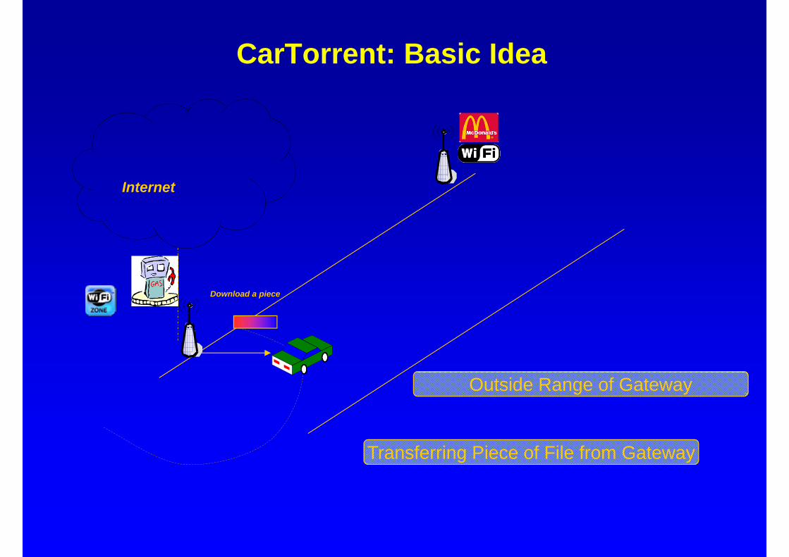
Solution: Co-operative P2P Downloading via Car-Torrent (like Bit Torrent in the Internet)
CarTorrent: Basic Idea
Download a piece
Internet
Transferring Piece of File from Gateway
Outside Range of Gateway
Co-operative Download: Car Torrent
Vehicle-Vehicle Communication
Internet
Exchanging Pieces of File Later

Vehicular Cloud computing
Observed trends:1. Vehicles perform increasingly more complex (sensor) data collection/processing
road alarms (pedestrian crossing, electr. brake lights, etc)cooperative content downloading via P2P car- torrent surveillance (video, mechanical, chemical sensors)road mapping via “crowd sourcing”accident, crime witnessing (for forensic investigations, etc)
2. Spectrum is scarce => Internet upload expensive
Enter Vehicular Cloud Computing:
Keep and process data on vehicle cloud instead of uploading to Internet cloud

Vehicle Cloud vs Internet Cloud
• Both offer a significant pool of resources:– computing, storage, communications
However:• Vehicular applications are mainly location relevant
– Data Sources: Drivers or environment– Customers: generally the drivers
• Vehicle cloud interacts with: – Internet cloud– Personal (smart phone) cloud
• Exception: emergency VANET– During an emergency the infrastructure is destroyed– Emergency cloud is isolated, works on its own power– Vehicle (especially E-vehicles) become the ONLY available
computing/comms resource

We review two emerging Vehicle Cloud applications
• Surveillance – Monitoring the environment events (natural or manmade)
• Urban Traffic management:– From totally centralized to locally distributed to evacuation

Surveillance Scenario: storage and retrieval
• Participating Cars ( busess, taxicabs, commuters): – Continuously collect images from the street (store data locally)– Process the data and detect an event– Classify the event as Meta-data (Type, Option, Loc, time,Vehicle ID)
• Question: how to access this info?
Meta-data : Img, -. (10,10), V10
CRASH
- Sensing - Processing
Crash Summary Reporting
Summary Harvesting

Mobility-assisted Meta-data Diffusion/Harvesting (Mobeyes 2007)
+ Broadcasting meta-data to neighbors+ Listen/store received meta-data
Periodical meta-data broadcasting
Agent harvests a set of missing meta-data from neighbors
HREQ
HREP

MobEyes: Mobility-assisted Epidemic Dissemination
• Mobeyes exploit “mobility” to disseminate meta-data!
• Source periodically broadcasts meta-data to neighbors– Only source can advertise meta-data– Neighbors store advertisements in their local memory– Drop stale data
• A mobile agent (the police) harvests meta-data from vehicles by querying them (with Bloom filter)

Urban Surveillance as a Service
• Suppose a green truck was involved in a suicidal terrorist attack – The truck blows up – The Agency wants to find out the approach path of the vehicle– Wants to learn if any accomplices drove along with the truck up to
the target
• Conventional solution: “road side” video cameras– Sophisticated attacker can avoid video cameras, or disable them
• Mobeyes based solution:– Reconstruct the path by using the other vehicles video cameras
• We have run a simulation experiment in a 2kmx2km area, with 100 vehicles roaming– Vehicles watch each other and agent reconstructs all paths

Trace Reconstruction

Trace Reconstruction

Vehicle Cloud for intelligent navigation
• GPS Based Navigators• Dash Express (came to market in 2008):
• Synergy between Navigator Server and City Transport Authority

NAVOPT – Navigator Assisted Route Optimization
•On Board Navigator– Interacts with the Server– Periodically transmits GPS and route– Receives route instructions
•Manhattan grid (10x10)– 5 routes (F1~ F5) from source to
destination– Link capacity: 14,925 [vehicles/h]
S ……
……
…
Shortest path
F1F3,4
F2
F3
F2,5
F5
F4
D

Analytic Results
0
0.05
0.1
0.15
0.2
0.25
0.3
0.35
0.4
0.45
13500 13600 13700 13800 13900 14000 14100 14200 14300 14400 14500 14600 14700 14800
Ave
rage
del
ay (h
our)
Total average delay (h/veh)
shortest path
flow deviation

Sumo simulation results
• Sumo-0.12– 10 X10 grid– Road segment: 400m– Length of vehicle: 4m– Max speed limit: 60Km/h
• Average delay– Delay increases drastically
around 15000 rate [veh/h] in case of shortest path
– In NAVOPT, delay slightly increases around 20000
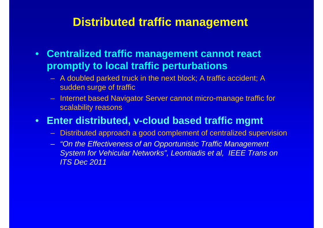
Distributed traffic management
• Centralized traffic management cannot react promptly to local traffic perturbations– A doubled parked truck in the next block; A traffic accident; A
sudden surge of traffic– Internet based Navigator Server cannot micro-manage traffic for
scalability reasons
• Enter distributed, v-cloud based traffic mgmt– Distributed approach a good complement of centralized supervision– “On the Effectiveness of an Opportunistic Traffic Management
System for Vehicular Networks”, Leontiadis et al, IEEE Trans on ITS Dec 2011

CATE: Comp Assisted Travl Environment
• Vehicles crowd source traffic information and traffic load data base:– 1) sensing traffic information;– 2) sharing it with neighboring vehicles (in an ad hoc manner); and– 3) dynamically recomputing the best route to destination from the
current position based on the collected information.
• The study was done by simulation:– QUALNET a popular event driven MANET simulator, and– MobiDense, a mobility simulator that combines topology and traffic
flow information to generate a mobility trace.– Case Study: Traffic pattern for Portland obtained from Los Alamos
Lab
• Potential limitations of CATE:– Delay in traffic loads propagation; lack of trip destination info

Traffic loading w/o CATE
Green no congest Yellow moderate Red heavy congest

Traffic loading with CATE
Green no congest Yellow moderate Red heavy congest
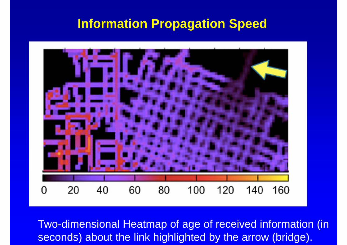
Information Propagation Speed
Two-dimensional Heatmap of age of received information (in seconds) about the link highlighted by the arrow (bridge).

CATE tested on C-VET
• Up to 8 vehicles roaming the Campus with GPS, WiFi radios and 250m range
• Static throughput between two nodes = 30Mps• At 30km/h througput = 7Mbps• Propagation of a 2MB block (traffic sample) from
one node to the other 7 nodes:– First vehicle received full block in 20s– Next four in < 72s– Last two in < 125s

Work ahead in Vehicle Cloud research
– Vehicle cloud formation and maintenance• Subclouds with common “social” interests
– In-Cloud networking• Cloud Content dissemination, storage, indexing,
search (Content Centric Networking)– Efficient spectrum usage (via cog radios)
• Exploit WiFi spectrum – short range• Exploit TV spectrum – long range connections (to
other vehicle clouds) – User-centric security and privacy protection– Interaction with Internet Cloud– Interaction with pedestrian (people) clouds

The End
Thank You