Embed Size (px)
Citation preview
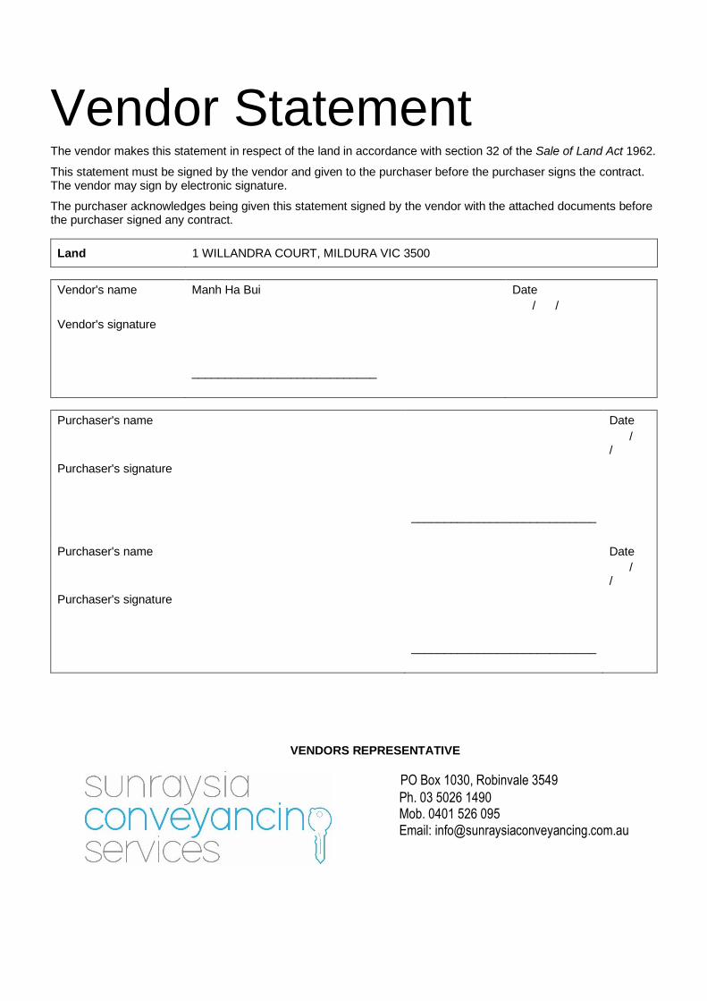
Vendor Statement The vendor makes this statement in respect of the land in accordance with section 32 of the Sale of Land Act 1962.
This statement must be signed by the vendor and given to the purchaser before the purchaser signs the contract. The vendor may sign by electronic signature.
The purchaser acknowledges being given this statement signed by the vendor with the attached documents before the purchaser signed any contract.
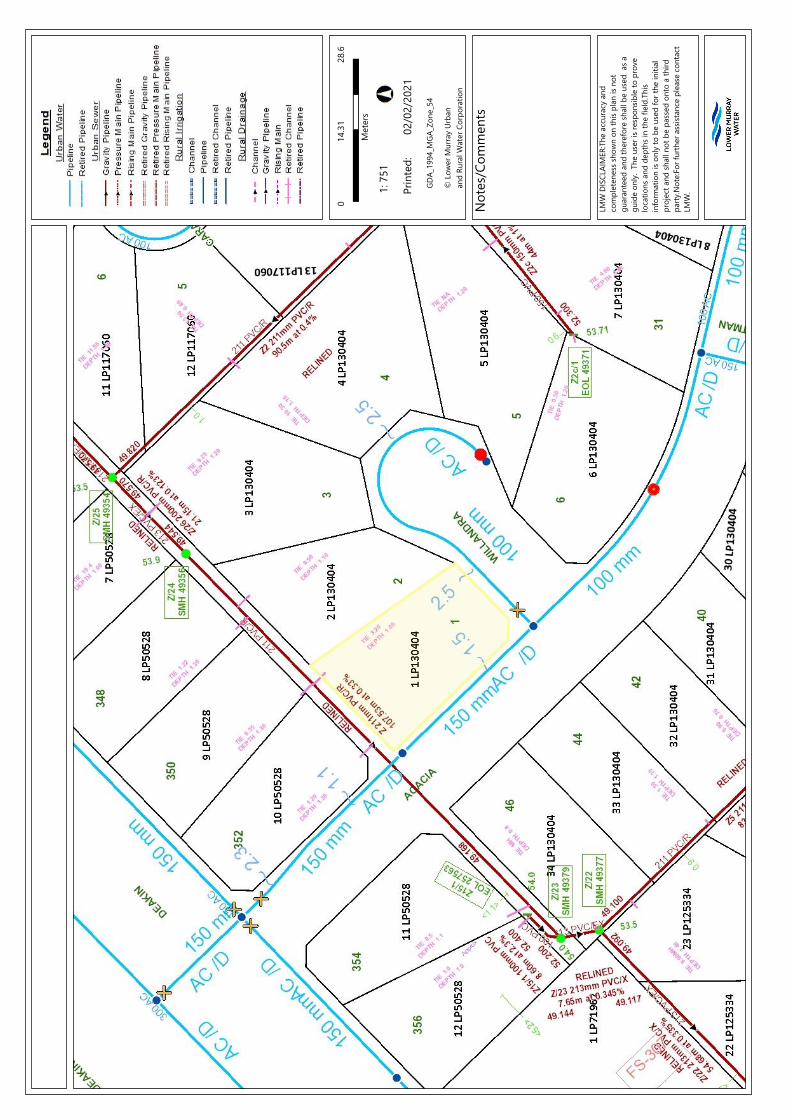
Land 1 WILLANDRA COURT, MILDURA VIC 3500
Vendor's name Manh Ha Bui Date
/ /
Vendor's signature
____________________________
Purchaser's name Date
/ /
Purchaser's signature
____________________________
Purchaser's name Date
/ /
Purchaser's signature
____________________________
VENDORS REPRESENTATIVE
PO Box 1030, Robinvale 3549
Ph. 03 5026 1490 Mob. 0401 526 095
Email: [email protected]
2
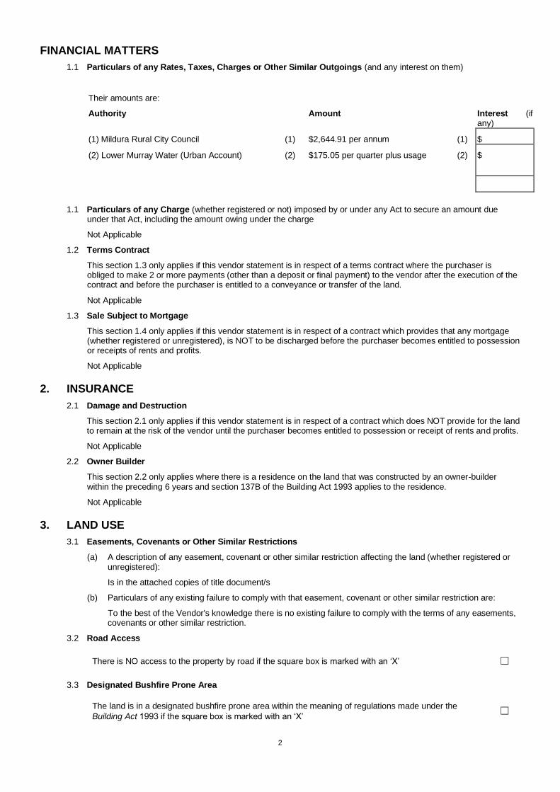
FINANCIAL MATTERS
1.1 Particulars of any Rates, Taxes, Charges or Other Similar Outgoings (and any interest on them)
Their amounts are:
Authority Amount Interest (if any)
(1) Mildura Rural City Council (1) $2,644.91 per annum (1) $
(2) Lower Murray Water (Urban Account)
(2)
$175.05 per quarter plus usage
(2) $
1.1 Particulars of any Charge (whether registered or not) imposed by or under any Act to secure an amount due under that Act, including the amount owing under the charge
Not Applicable
1.2 Terms Contract
This section 1.3 only applies if this vendor statement is in respect of a terms contract where the purchaser is obliged to make 2 or more payments (other than a deposit or final payment) to the vendor after the execution of the contract and before the purchaser is entitled to a conveyance or transfer of the land.
Not Applicable
1.3 Sale Subject to Mortgage
This section 1.4 only applies if this vendor statement is in respect of a contract which provides that any mortgage (whether registered or unregistered), is NOT to be discharged before the purchaser becomes entitled to possession or receipts of rents and profits.
Not Applicable
2. INSURANCE
2.1 Damage and Destruction
This section 2.1 only applies if this vendor statement is in respect of a contract which does NOT provide for the land to remain at the risk of the vendor until the purchaser becomes entitled to possession or receipt of rents and profits.
Not Applicable
2.2 Owner Builder
This section 2.2 only applies where there is a residence on the land that was constructed by an owner-builder within the preceding 6 years and section 137B of the Building Act 1993 applies to the residence.
Not Applicable
3. LAND USE
3.1 Easements, Covenants or Other Similar Restrictions
(a) A description of any easement, covenant or other similar restriction affecting the land (whether registered or unregistered):
Is in the attached copies of title document/s
(b) Particulars of any existing failure to comply with that easement, covenant or other similar restriction are:
To the best of the Vendor's knowledge there is no existing failure to comply with the terms of any easements, covenants or other similar restriction.
3.2 Road Access
There is NO access to the property by road if the square box is marked with an ‘X’ ☐
3.3 Designated Bushfire Prone Area
The land is in a designated bushfire prone area within the meaning of regulations made under the
Building Act 1993 if the square box is marked with an ‘X’ ☐
3
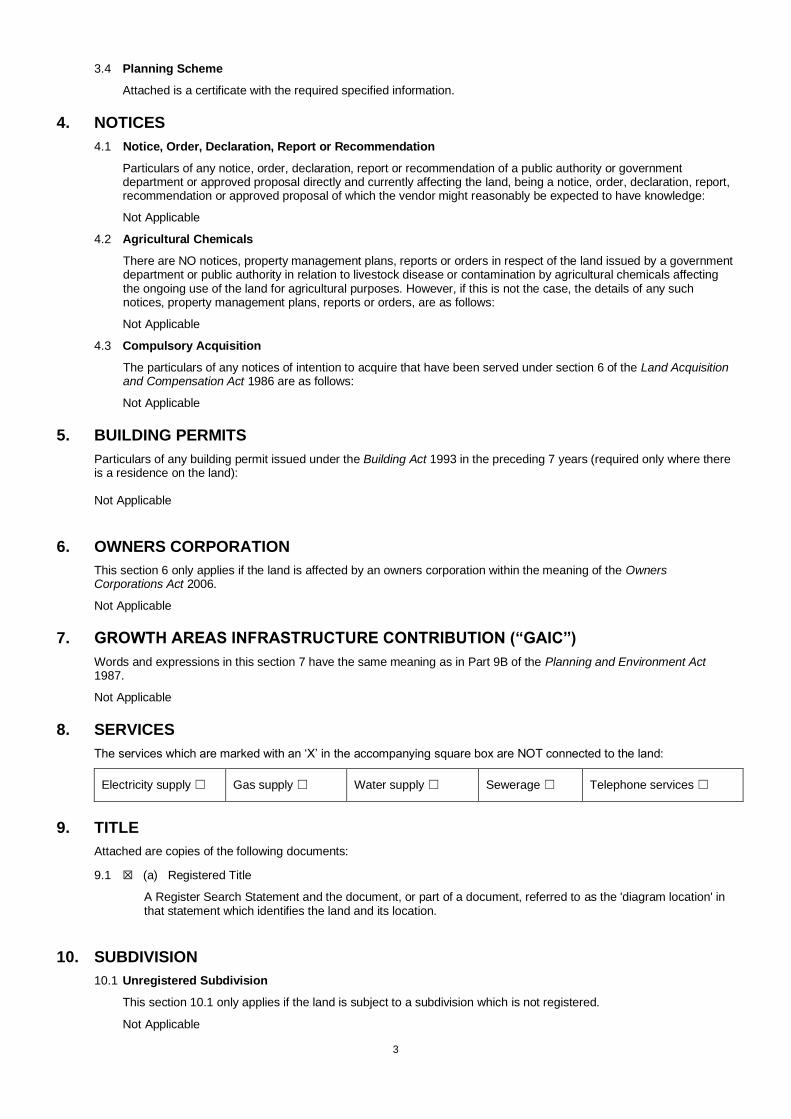
3.4 Planning Scheme
Attached is a certificate with the required specified information.
4. NOTICES
4.1 Notice, Order, Declaration, Report or Recommendation
Particulars of any notice, order, declaration, report or recommendation of a public authority or government department or approved proposal directly and currently affecting the land, being a notice, order, declaration, report, recommendation or approved proposal of which the vendor might reasonably be expected to have knowledge:
Not Applicable
4.2 Agricultural Chemicals
There are NO notices, property management plans, reports or orders in respect of the land issued by a government department or public authority in relation to livestock disease or contamination by agricultural chemicals affecting the ongoing use of the land for agricultural purposes. However, if this is not the case, the details of any such notices, property management plans, reports or orders, are as follows:
Not Applicable
4.3 Compulsory Acquisition
The particulars of any notices of intention to acquire that have been served under section 6 of the Land Acquisition and Compensation Act 1986 are as follows:
Not Applicable
5. BUILDING PERMITS
Particulars of any building permit issued under the Building Act 1993 in the preceding 7 years (required only where there is a residence on the land): Not Applicable
6. OWNERS CORPORATION
This section 6 only applies if the land is affected by an owners corporation within the meaning of the Owners Corporations Act 2006.
Not Applicable
7. GROWTH AREAS INFRASTRUCTURE CONTRIBUTION (“GAIC”)
Words and expressions in this section 7 have the same meaning as in Part 9B of the Planning and Environment Act 1987.
Not Applicable
8. SERVICES
The services which are marked with an ‘X’ in the accompanying square box are NOT connected to the land:
Electricity supply ☐ Gas supply ☐ Water supply ☐ Sewerage ☐ Telephone services ☐
9. TITLE
Attached are copies of the following documents:
9.1 ☒ (a) Registered Title
A Register Search Statement and the document, or part of a document, referred to as the 'diagram location' in that statement which identifies the land and its location.
10. SUBDIVISION
10.1 Unregistered Subdivision
This section 10.1 only applies if the land is subject to a subdivision which is not registered.
Not Applicable
4
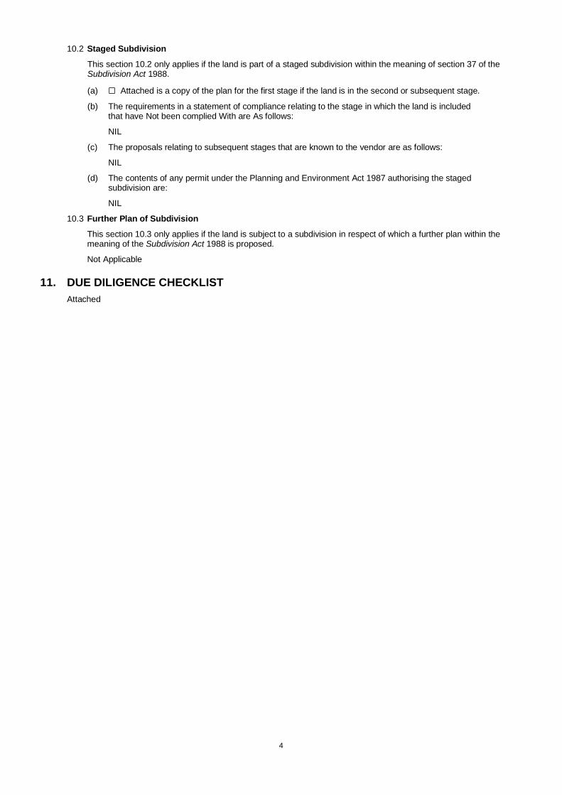
10.2 Staged Subdivision
This section 10.2 only applies if the land is part of a staged subdivision within the meaning of section 37 of the Subdivision Act 1988.
(a) ☐ Attached is a copy of the plan for the first stage if the land is in the second or subsequent stage.
(b) The requirements in a statement of compliance relating to the stage in which the land is included that have Not been complied With are As follows:
NIL
(c) The proposals relating to subsequent stages that are known to the vendor are as follows:
NIL
(d) The contents of any permit under the Planning and Environment Act 1987 authorising the staged subdivision are:
NIL
10.3 Further Plan of Subdivision
This section 10.3 only applies if the land is subject to a subdivision in respect of which a further plan within the meaning of the Subdivision Act 1988 is proposed.
Not Applicable
11. DUE DILIGENCE CHECKLIST
Attached
(04/10/2016)
consumer.vic.gov.au/duediligencechecklist Page 1 of 2
Due diligence checklist
What you need to know before buying a residential property Before you buy a home, you should be aware of a range of issues that may affect that property and impose restrictions
or obligations on you, if you buy it. This checklist aims to help you identify whether any of these issues will affect you.
The questions are a starting point only and you may need to seek professional advice to answer some of them. You
can find links to organisations and web pages that can help you learn more, by visiting the Due diligence checklist page
on the Consumer Affairs Victoria website (consumer.vic.gov.au/duediligencechecklist).
Urban living
Moving to the inner city?
High density areas are attractive for their entertainment and service areas, but these activities create increased traffic
as well as noise and odours from businesses and people. Familiarising yourself with the character of the area will give
you a balanced understanding of what to expect.
Is the property subject to an owners corporation?
If the property is part of a subdivision with common property such as driveways or grounds, it may be subject to an
owners corporation. You may be required to pay fees and follow rules that restrict what you can do on your property,
such as a ban on pet ownership.
Growth areas
Are you moving to a growth area?
You should investigate whether you will be required to pay a growth areas infrastructure contribution.
Flood and fire risk
Does this property experience flooding or bushfire?
Properties are sometimes subject to the risk of fire and flooding due to their location. You should properly investigate
these risks and consider their implications for land management, buildings and insurance premiums.
Rural properties
Moving to the country?
If you are looking at property in a rural zone, consider:
• Is the surrounding land use compatible with your lifestyle expectations? Farming can create noise or odour that may
be at odds with your expectations of a rural lifestyle.
• Are you considering removing native vegetation? There are regulations which affect your ability to remove native
vegetation on private property.
• Do you understand your obligations to manage weeds and pest animals?
Can you build new dwellings?
Does the property adjoin crown land, have a water frontage, contain a disused government road, or are there any
crown licences associated with the land?
Is there any earth resource activity such as mining in the area?
You may wish to find out more about exploration, mining and quarrying activity on or near the property and consider
the issue of petroleum, geothermal and greenhouse gas sequestration permits, leases and licences, extractive industry
authorisations and mineral licences.
Soil and groundwater contamination
Has previous land use affected the soil or groundwater?
You should consider whether past activities, including the use of adjacent land, may have caused contamination at the
site and whether this may prevent you from doing certain things to or on the land in the future.
Page 2 of 2
Land boundaries
Do you know the exact boundary of the property?
You should compare the measurements shown on the title document with actual fences and buildings on the property,
to make sure the boundaries match. If you have concerns about this, you can speak to your lawyer or conveyancer, or
commission a site survey to establish property boundaries.
Planning controls
Can you change how the property is used, or the buildings on it?
All land is subject to a planning scheme, run by the local council. How the property is zoned and any overlays that may
apply, will determine how the land can be used. This may restrict such things as whether you can build on vacant land
or how you can alter or develop the land and its buildings over time.
The local council can give you advice about the planning scheme, as well as details of any other restrictions that may
apply, such as design guidelines or bushfire safety design. There may also be restrictions – known as encumbrances –
on the property’s title, which prevent you from developing the property. You can find out about encumbrances by
looking at the section 32 statement.
Are there any proposed or granted planning permits?
The local council can advise you if there are any proposed or issued planning permits for any properties close by.
Significant developments in your area may change the local ‘character’ (predominant style of the area) and may
increase noise or traffic near the property.
Safety
Is the building safe to live in?
Building laws are in place to ensure building safety. Professional building inspections can help you assess the property
for electrical safety, possible illegal building work, adequate pool or spa fencing and the presence of asbestos,
termites, or other potential hazards.
Building permits
Have any buildings or retaining walls on the property been altered, or do you plan to alter them?
There are laws and regulations about how buildings and retaining walls are constructed, which you may wish to
investigate to ensure any completed or proposed building work is approved. The local council may be able to give you
information about any building permits issued for recent building works done to the property, and what you must do to
plan new work. You can also commission a private building surveyor’s assessment.
Are any recent building or renovation works covered by insurance?
Ask the vendor if there is any owner-builder insurance or builder’s warranty to cover defects in the work done to the
property.
Utilities and essential services
Does the property have working connections for water, sewerage, electricity, gas, telephone and internet?
Unconnected services may not be available, or may incur a fee to connect. You may also need to choose from a range
of suppliers for these services. This may be particularly important in rural areas where some services are not available.
Buyers’ rights
Do you know your rights when buying a property?
The contract of sale and section 32 statement contain important information about the property, so you should request
to see these and read them thoroughly. Many people engage a lawyer or conveyancer to help them understand the
contracts and ensure the sale goes through correctly. If you intend to hire a professional, you should consider speaking
to them before you commit to the sale. There are also important rules about the way private sales and auctions are
conducted. These may include a cooling-off period and specific rights associated with ‘off the plan’ sales. The
important thing to remember is that, as the buyer, you have rights.

VOLUME 09341 FOLIO 480 Security no : 124087885049C Produced 02/02/2021 02:42 PM
LAND DESCRIPTION
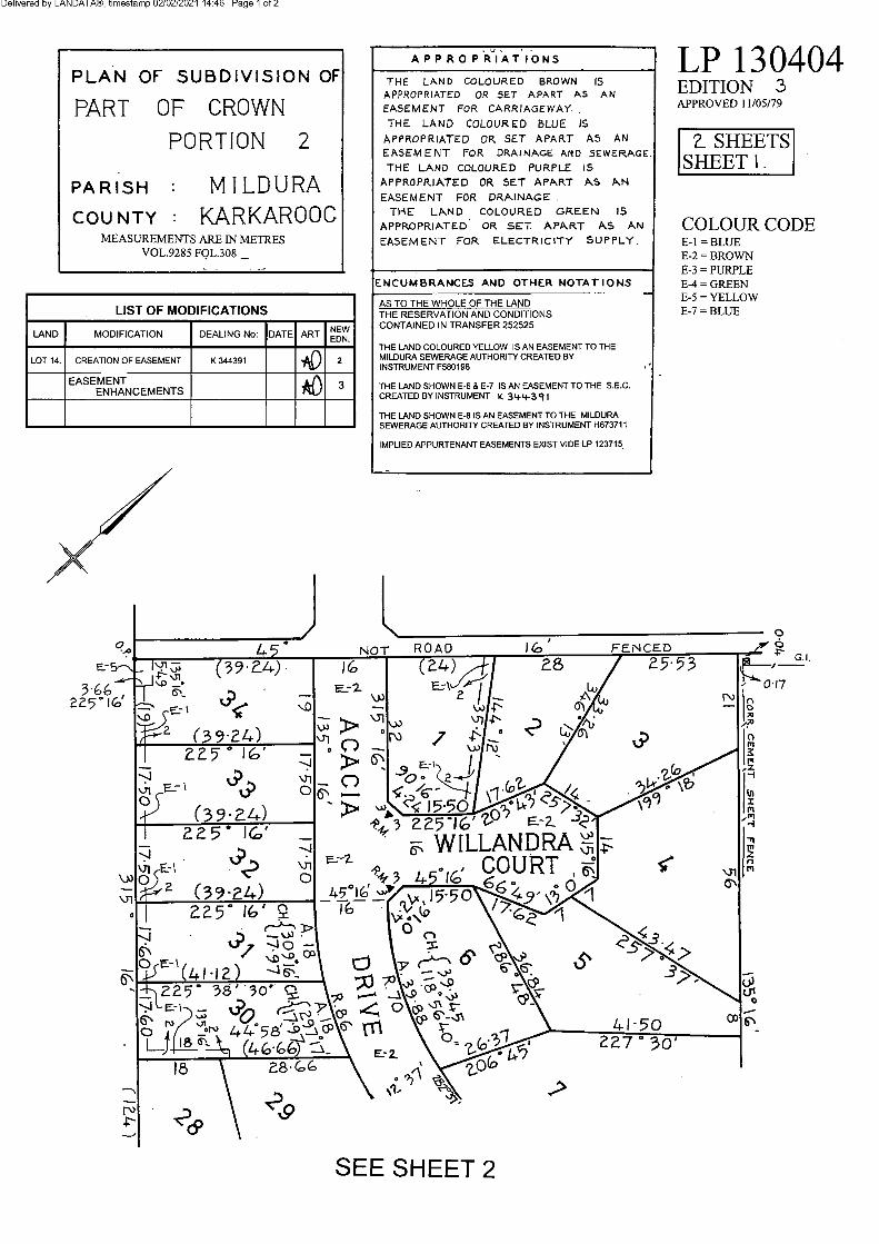
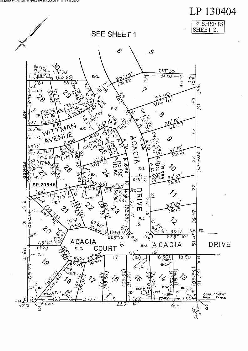
Lot 1 on Plan of Subdivision 130404.PARENT TITLE Volume 09285 Folio 308Created by instrument LP130404 05/07/1979
REGISTERED PROPRIETOR
Estate Fee SimpleSole Proprietor MANH HA BUI of 4 ALBERT STREET REVESBY NSW 2212 AS795899B 10/12/2019
ENCUMBRANCES, CAVEATS AND NOTICES
MORTGAGE AS795900V 10/12/2019 AUSTRALIA AND NEW ZEALAND BANKING GROUP LTD
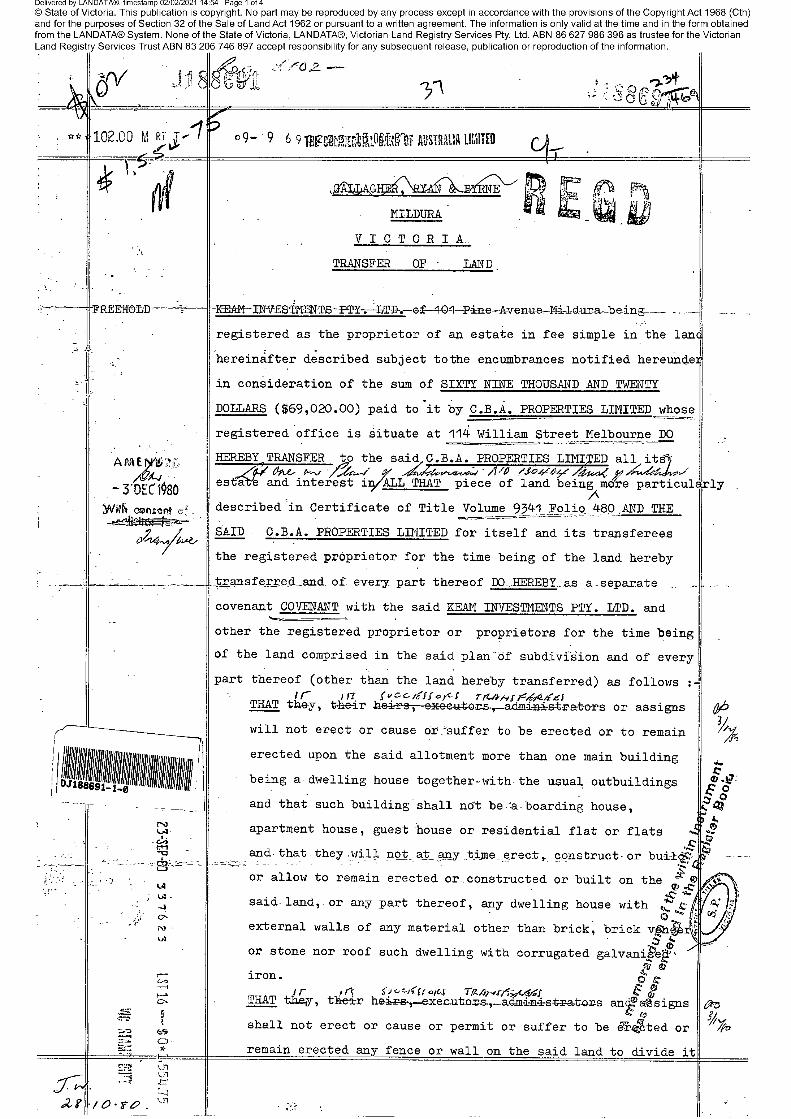
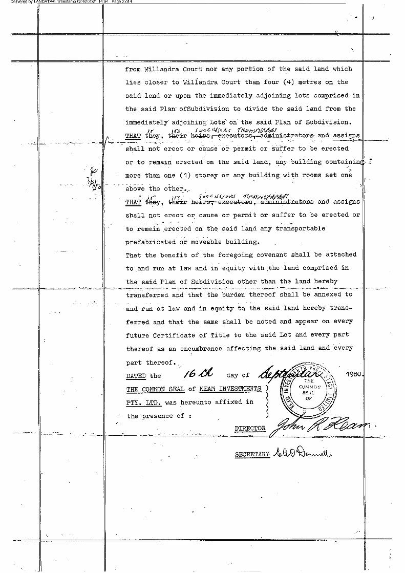
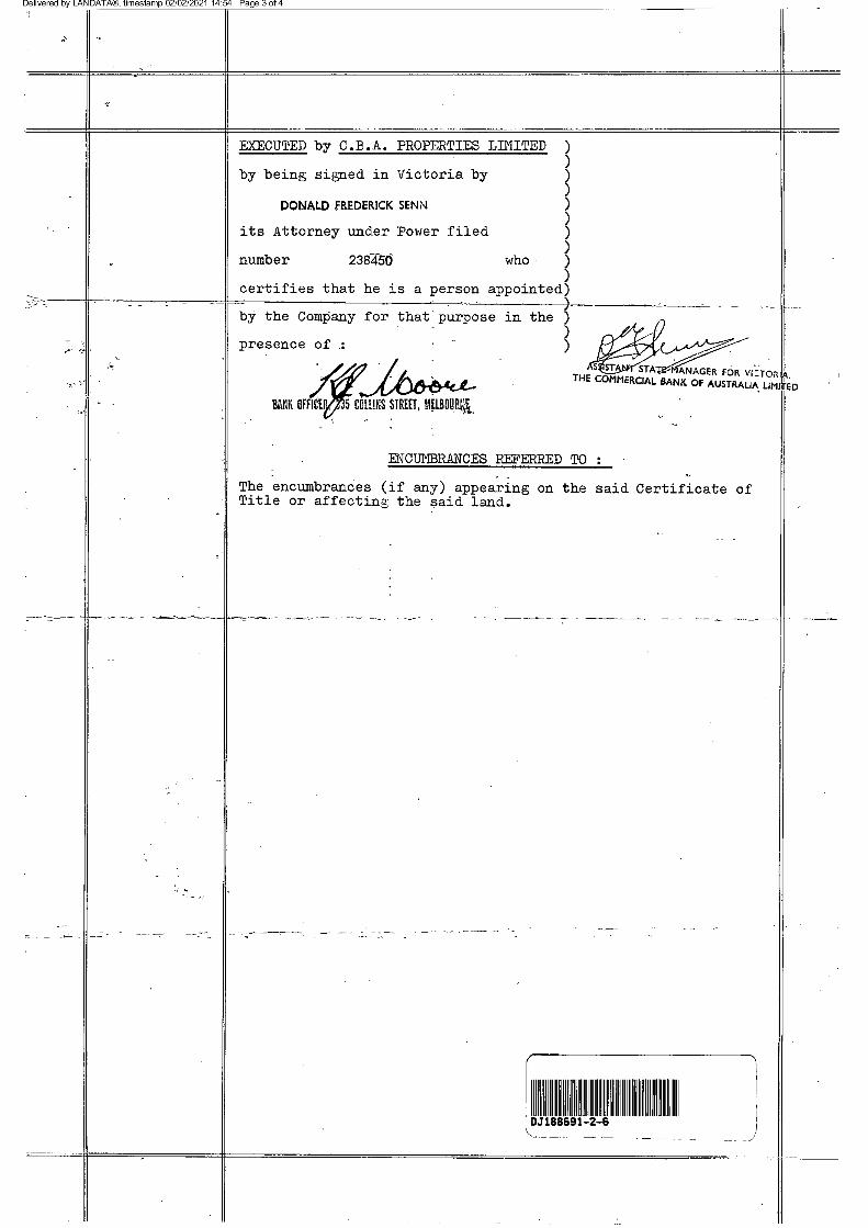
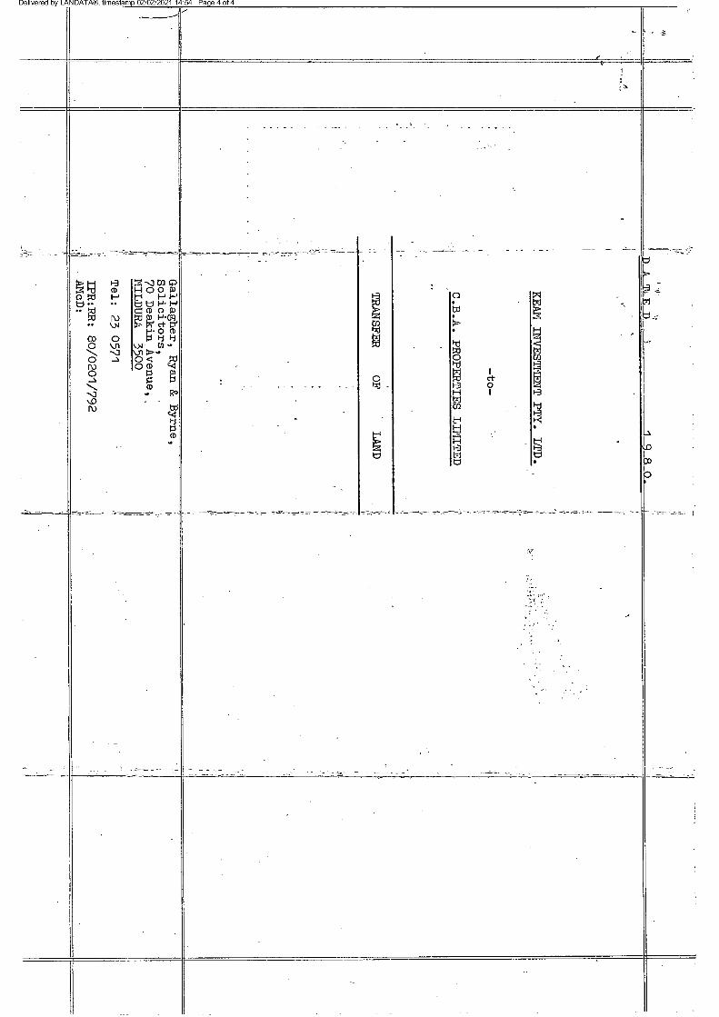
COVENANT J188691 13/10/1980
Any encumbrances created by Section 98 Transfer of Land Act 1958 or Section 24 Subdivision Act 1988 and any other encumbrances shown or entered on the plan or imaged folio set out under DIAGRAM LOCATION below.
DIAGRAM LOCATION
SEE LP130404 FOR FURTHER DETAILS AND BOUNDARIES
ACTIVITY IN THE LAST 125 DAYS
NIL
------------------------END OF REGISTER SEARCH STATEMENT------------------------
Additional information: (not part of the Register Search Statement)
Street Address: 1 WILLANDRA COURT MILDURA VIC 3500
ADMINISTRATIVE NOTICES
NIL
eCT Control 16165A ANZ RETAIL AND SMALL BUSINESSEffective from 10/12/2019
DOCUMENT END
Copyright State of Victoria. This publication is copyright. No part may be reproduced by any process except in accordance with the provisions of the Copyright Act 1968 (Cth) and for thepurposes of Section 32 of the Sale of Land Act 1962 (Vic) or pursuant to a written agreement. The information is only valid at the time and in the form obtained from the LANDATA REGDTM System. None of the State of Victoria, LANDATA REGD TM System, Victorian Land Registry Services Pty. Ltd. ABN 86 627 986 396 as trustee for the Victorian Land Registry ServicesTrust ABN 83 206 746 897 accept responsibility for any subsequent release, publication or reproduction of the information.
REGISTER SEARCH STATEMENT (Title Search) Transfer of Land Act 1958
Page 1 of 1
Title 9341/480 Page 1 of 1
Imaged Document Cover Sheet
The document following this cover sheet is an imaged document supplied by LANDATA®, Victorian Land Registry Services.
Document Type Plan
Document Identification LP130404
Number of Pages
(excluding this cover sheet)
2
Document Assembled 02/02/2021 14:46
Copyright and disclaimer notice:© State of Victoria. This publication is copyright. No part may be reproduced by any process exceptin accordance with the provisions of the Copyright Act 1968 (Cth) and for the purposes of Section 32of the Sale of Land Act 1962 or pursuant to a written agreement. The information is only valid at thetime and in the form obtained from the LANDATA® System. None of the State of Victoria,LANDATA®, Victorian Land Registry Services Pty. Ltd. ABN 86 627 986 396 as trustee for theVictorian Land Registry Services Trust ABN 83 206 746 897 accept responsibility for anysubsequent release, publication or reproduction of the information.
The document is invalid if this cover sheet is removed or altered.
Imaged Document Cover Sheet
The document following this cover sheet is an imaged document supplied by LANDATA®, Victorian Land Registry Services.
Document Type Instrument
Document Identification J188691
Number of Pages
(excluding this cover sheet)
4
Document Assembled 02/02/2021 14:54
Copyright and disclaimer notice:© State of Victoria. This publication is copyright. No part may be reproduced by any process exceptin accordance with the provisions of the Copyright Act 1968 (Cth) and for the purposes of Section 32of the Sale of Land Act 1962 or pursuant to a written agreement. The information is only valid at thetime and in the form obtained from the LANDATA® System. None of the State of Victoria,LANDATA®, Victorian Land Registry Services Pty. Ltd. ABN 86 627 986 396 as trustee for theVictorian Land Registry Services Trust ABN 83 206 746 897 accept responsibility for anysubsequent release, publication or reproduction of the information.
The document is invalid if this cover sheet is removed or altered.
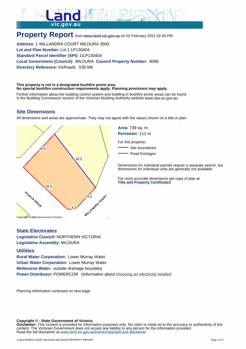
Property Report from www.land.vic.gov.au on 02 February 2021 02:40 PM
Address: 1 WILLANDRA COURT MILDURA 3500Lot and Plan Number: Lot 1 LP130404 Standard Parcel Identifier (SPI): 1\LP130404Local Government (Council): MILDURA Council Property Number: 8068Directory Reference: VicRoads 535 M9
This property is not in a designated bushfire prone area.No special bushfire construction requirements apply. Planning provisions may apply.
Further information about the building control system and building in bushfire prone areas can be found in the Building Commission section of the Victorian Building Authority website www.vba.vic.gov.au
Site DimensionsAll dimensions and areas are approximate. They may not agree with the values shown on a title or plan.
Area: 739 sq. mPerimeter: 111 m
For this property:
Site boundaries
Road frontages
Dimensions for individual parcels require a separate search, butdimensions for individual units are generally not available.
For more accurate dimensions get copy of plan atTitle and Property Certificates
State ElectoratesLegislative Council: NORTHERN VICTORIALegislative Assembly: MILDURA
UtilitiesRural Water Corporation: Lower Murray WaterUrban Water Corporation: Lower Murray WaterMelbourne Water: outside drainage boundaryPower Distributor: POWERCOR (Information about choosing an electricity retailer)
Planning information continued on next page
Copyright © - State Government of VictoriaDisclaimer: This content is provided for information purposes only. No claim is made as to the accuracy or authenticity of thecontent. The Victorian Government does not accept any liability to any person for the information provided.Read the full disclaimer at www.land.vic.gov.au/home/copyright-and-disclaimer
1-WILLANDRA-COURT-MILDURA-DETAILED-PROPERTY-REPORT Page 1 of 2
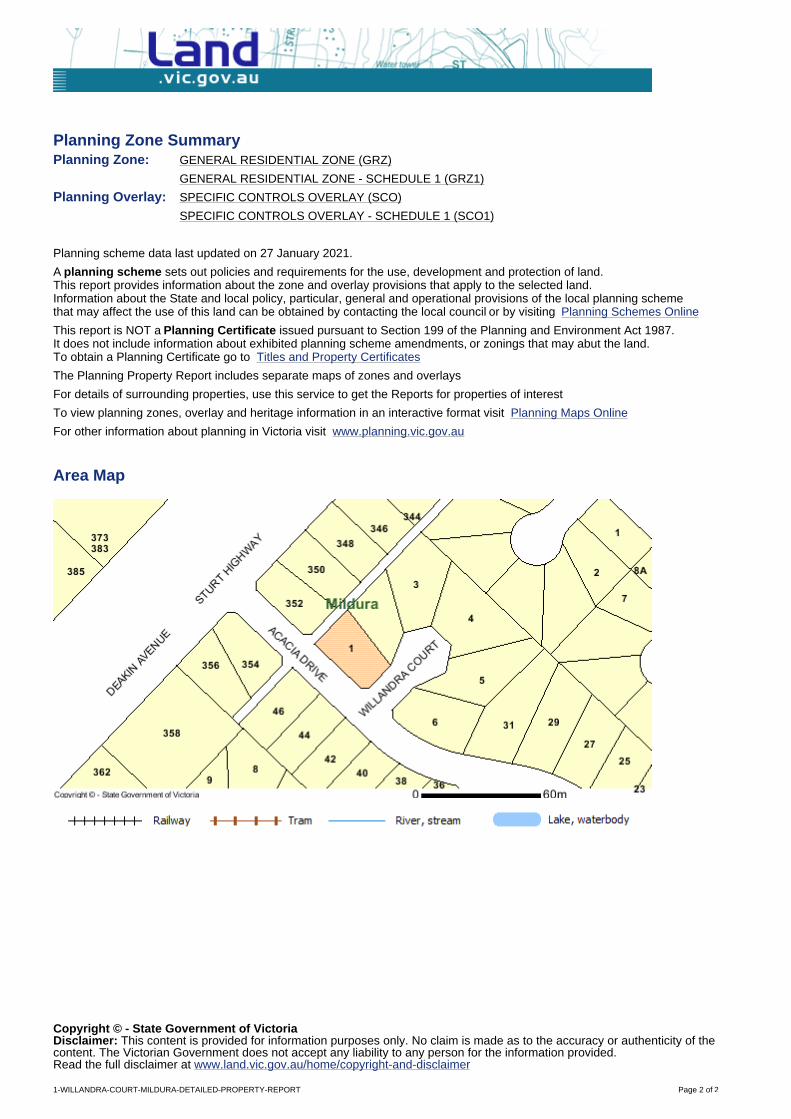
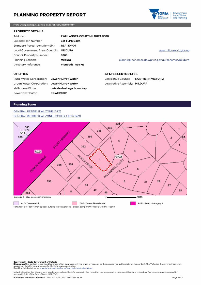
Planning Zone SummaryPlanning Zone: GENERAL RESIDENTIAL ZONE (GRZ)
GENERAL RESIDENTIAL ZONE - SCHEDULE 1 (GRZ1)
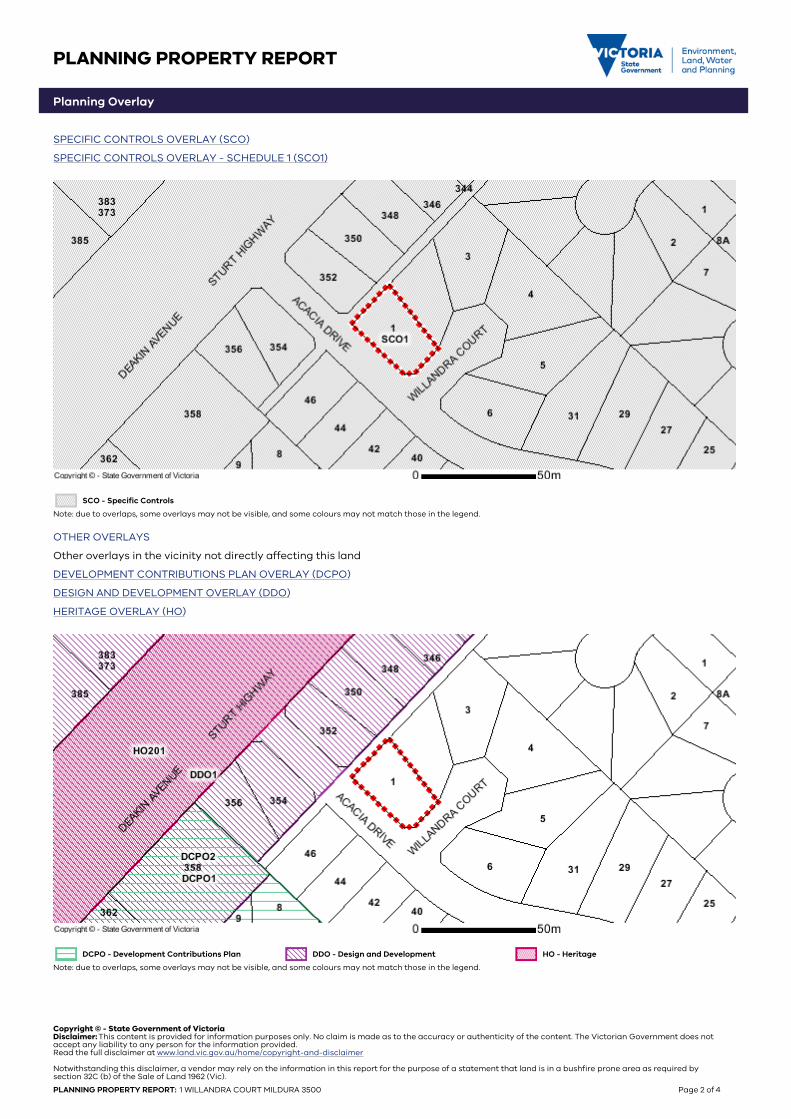
Planning Overlay: SPECIFIC CONTROLS OVERLAY (SCO)
SPECIFIC CONTROLS OVERLAY - SCHEDULE 1 (SCO1)
Planning scheme data last updated on 27 January 2021.
A planning scheme sets out policies and requirements for the use, development and protection of land. This report provides information about the zone and overlay provisions that apply to the selected land.Information about the State and local policy, particular, general and operational provisions of the local planning scheme that may affect the use of this land can be obtained by contacting the local council or by visiting Planning Schemes Online
This report is NOT a Planning Certificate issued pursuant to Section 199 of the Planning and Environment Act 1987.It does not include information about exhibited planning scheme amendments, or zonings that may abut the land. To obtain a Planning Certificate go to Titles and Property Certificates
The Planning Property Report includes separate maps of zones and overlays
For details of surrounding properties, use this service to get the Reports for properties of interest
To view planning zones, overlay and heritage information in an interactive format visit Planning Maps Online
For other information about planning in Victoria visit www.planning.vic.gov.au
Area Map
Copyright © - State Government of VictoriaDisclaimer: This content is provided for information purposes only. No claim is made as to the accuracy or authenticity of thecontent. The Victorian Government does not accept any liability to any person for the information provided.Read the full disclaimer at www.land.vic.gov.au/home/copyright-and-disclaimer
1-WILLANDRA-COURT-MILDURA-DETAILED-PROPERTY-REPORT Page 2 of 2
PLANNING PROPERTY REPORT
From www.planning.vic.gov.au on 02 February 2021 02:40 PM
PROPERTY DETAILS
Address: 1 WILLANDRA COURT MILDURA 3500
Lot and Plan Number: Lot 1 LP130404
Standard Parcel Identifier (SPI): 1\LP130404
Local Government Area (Council): MILDURA www.mildura.vic.gov.au
Council Property Number: 8068
Planning Scheme: Mildura planning-schemes.delwp.vic.gov.au/schemes/mildura
Directory Reference: VicRoads 535 M9
STATE ELECTORATES
Legislative Council: NORTHERN VICTORIA
Legislative Assembly: MILDURA
UTILITIES
Rural Water Corporation: Lower Murray Water
Urban Water Corporation: Lower Murray Water
Melbourne Water: outside drainage boundary
Power Distributor: POWERCOR
Planning Zones
GENERAL RESIDENTIAL ZONE (GRZ)
GENERAL RESIDENTIAL ZONE - SCHEDULE 1 (GRZ1)
C1Z - Commercial 1 GRZ - General Residential RDZ1 - Road - Category 1
Note: labels for zones may appear outside the actual zone - please compare the labels with the legend.
Copyright © - State Government of VictoriaDisclaimer: This content is provided for information purposes only. No claim is made as to the accuracy or authenticity of the content. The Victorian Government does notaccept any liability to any person for the information provided.Read the full disclaimer at www.land.vic.gov.au/home/copyright-and-disclaimer
Notwithstanding this disclaimer, a vendor may rely on the information in this report for the purpose of a statement that land is in a bushfire prone area as required bysection 32C (b) of the Sale of Land 1962 (Vic).
PLANNING PROPERTY REPORT: 1 WILLANDRA COURT MILDURA 3500 Page 1 of 4
PLANNING PROPERTY REPORT
Planning Overlay
SPECIFIC CONTROLS OVERLAY (SCO)
SPECIFIC CONTROLS OVERLAY - SCHEDULE 1 (SCO1)
SCO - Specific Controls
Note: due to overlaps, some overlays may not be visible, and some colours may not match those in the legend.
OTHER OVERLAYS
Other overlays in the vicinity not directly affecting this land
DEVELOPMENT CONTRIBUTIONS PLAN OVERLAY (DCPO)
DESIGN AND DEVELOPMENT OVERLAY (DDO)
HERITAGE OVERLAY (HO)
DCPO - Development Contributions Plan DDO - Design and Development HO - Heritage
Note: due to overlaps, some overlays may not be visible, and some colours may not match those in the legend.
Copyright © - State Government of VictoriaDisclaimer: This content is provided for information purposes only. No claim is made as to the accuracy or authenticity of the content. The Victorian Government does notaccept any liability to any person for the information provided.Read the full disclaimer at www.land.vic.gov.au/home/copyright-and-disclaimer
Notwithstanding this disclaimer, a vendor may rely on the information in this report for the purpose of a statement that land is in a bushfire prone area as required bysection 32C (b) of the Sale of Land 1962 (Vic).
PLANNING PROPERTY REPORT: 1 WILLANDRA COURT MILDURA 3500 Page 2 of 4
PLANNING PROPERTY REPORT
Further Planning Information
Planning scheme data last updated on 27 January 2021.
A planning scheme sets out policies and requirements for the use, development and protection of land. This report provides information about the zone and overlay provisions that apply to the selected land.Information about the State and local policy, particular, general and operational provisions of the local planning scheme that may affect the use of this land can be obtained by contacting the local councilor by visiting https://www.planning.vic.gov.au
This report is NOT a Planning Certificate issued pursuant to Section 199 of the Planning and Environment Act 1987.It does not include information about exhibited planning scheme amendments, or zonings that may abut the land. To obtain a Planning Certificate go to Titles and Property Certificates at Landata - https://www.landata.vic.gov.au
For details of surrounding properties, use this service to get the Reports for properties of interest.
To view planning zones, overlay and heritage information in an interactive format visit http://mapshare.maps.vic.gov.au/vicplan
For other information about planning in Victoria visit https://www.planning.vic.gov.au
Copyright © - State Government of VictoriaDisclaimer: This content is provided for information purposes only. No claim is made as to the accuracy or authenticity of the content. The Victorian Government does notaccept any liability to any person for the information provided.Read the full disclaimer at www.land.vic.gov.au/home/copyright-and-disclaimer
Notwithstanding this disclaimer, a vendor may rely on the information in this report for the purpose of a statement that land is in a bushfire prone area as required bysection 32C (b) of the Sale of Land 1962 (Vic).
PLANNING PROPERTY REPORT: 1 WILLANDRA COURT MILDURA 3500 Page 3 of 4
PLANNING PROPERTY REPORT
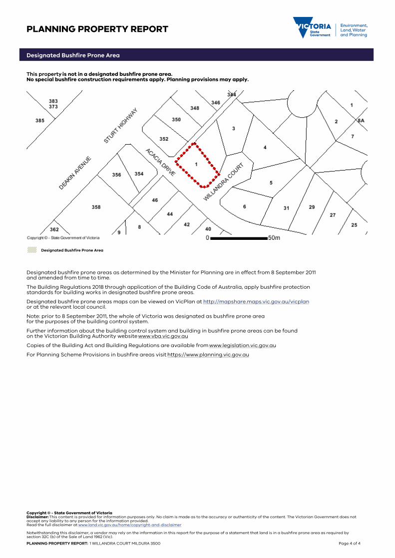
Designated Bushfire Prone Area
This property is not in a designated bushfire prone area.No special bushfire construction requirements apply. Planning provisions may apply.
Designated Bushfire Prone Area
Designated bushfire prone areas as determined by the Minister for Planning are in effect from 8 September 2011and amended from time to time.
The Building Regulations 2018 through application of the Building Code of Australia, apply bushfire protection standards for building works in designated bushfire prone areas.
Designated bushfire prone areas maps can be viewed on VicPlan at http://mapshare.maps.vic.gov.au/vicplanor at the relevant local council.
Note: prior to 8 September 2011, the whole of Victoria was designated as bushfire prone area for the purposes of the building control system.
Further information about the building control system and building in bushfire prone areas can be found on the Victorian Building Authority website www.vba.vic.gov.au
Copies of the Building Act and Building Regulations are available from www.legislation.vic.gov.au
For Planning Scheme Provisions in bushfire areas visit https://www.planning.vic.gov.au
Copyright © - State Government of VictoriaDisclaimer: This content is provided for information purposes only. No claim is made as to the accuracy or authenticity of the content. The Victorian Government does notaccept any liability to any person for the information provided.Read the full disclaimer at www.land.vic.gov.au/home/copyright-and-disclaimer
Notwithstanding this disclaimer, a vendor may rely on the information in this report for the purpose of a statement that land is in a bushfire prone area as required bysection 32C (b) of the Sale of Land 1962 (Vic).
PLANNING PROPERTY REPORT: 1 WILLANDRA COURT MILDURA 3500 Page 4 of 4
������������� ����������������
���������������������������������������
�������������������� ����������!�������������
����������"�� �������������������!���������#��
���������������������������� ����" ����
�� ��������������������!������� ���������������
���$������������������!����������������������
�����"%����&��� �������������������������������
�����"'��������������(�!��)�*+,,-*�)*.���*
/-������01"2%����3�������� �+-"4+5 6/++� 503503050+7������� ���������������������
������
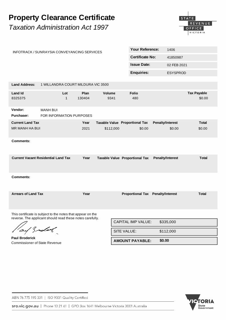
Your Reference:
Issue Date:
Enquiries:
41850987
02 FEB 2021
ESYSPROD
1406
Certificate No:
Vendor: MANH BUI
Purchaser: FOR INFORMATION PURPOSES
This certificate is subject to the notes that appear on the reverse. The applicant should read these notes carefully.
Land Address: 1 WILLANDRA COURT MILDURA VIC 3500
$0.00AMOUNT PAYABLE:
Year Proportional Tax Penalty/Interest Total
INFOTRACK / SUNRAYSIA CONVEYANCING SERVICES
$112,000
Comments:
Arrears of Land Tax
Paul Broderick
Property Clearance CertificateTaxation Administration Act 1997
Land Id8325375
Lot Plan Volume Folio1 130404 9341 480
Tax Payable $0.00
Commissioner of State Revenue
Current Land Tax Proportional Tax TotalPenalty/InterestYear
MR MANH HA BUI $0.00 $0.00 $0.002021
Taxable Value
$112,000
Current Vacant Residential Land Tax Proportional Tax TotalPenalty/InterestYear Taxable Value
Comments:
$335,000CAPITAL IMP VALUE:
SITE VALUE:
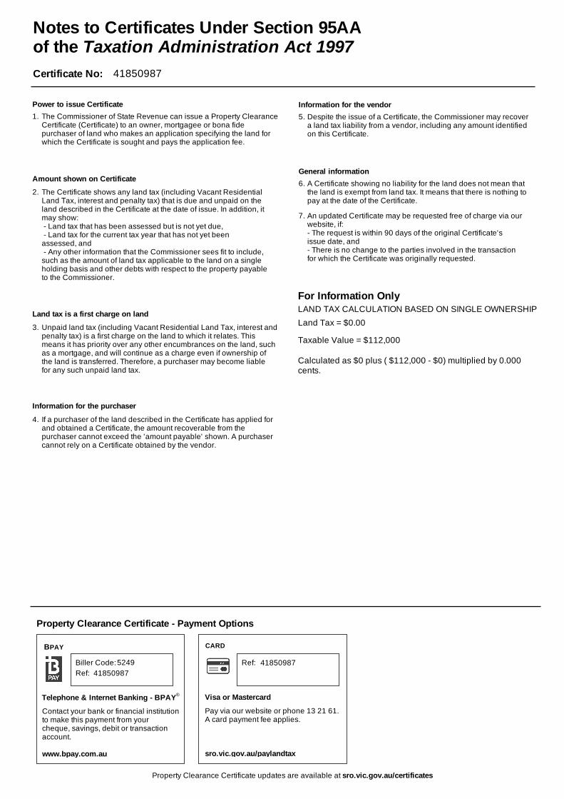
Certificate No: 41850987
Unpaid land tax (including Vacant Residential Land Tax, interest andpenalty tax) is a first charge on the land to which it relates. This means it has priority over any other encumbrances on the land, suchas a mortgage, and will continue as a charge even if ownership of the land is transferred. Therefore, a purchaser may become liable for any such unpaid land tax.
If a purchaser of the land described in the Certificate has applied for and obtained a Certificate, the amount recoverable from the purchaser cannot exceed the 'amount payable' shown. A purchaser cannot rely on a Certificate obtained by the vendor.
Despite the issue of a Certificate, the Commissioner may recover a land tax liability from a vendor, including any amount identified on this Certificate.
A Certificate showing no liability for the land does not mean that the land is exempt from land tax. It means that there is nothing to pay at the date of the Certificate.
For Information Only
Property Clearance Certificate updates are available at sro.vic.gov.au/certificates
Notes to Certificates Under Section 95AAof the Taxation Administration Act 1997
The Commissioner of State Revenue can issue a Property ClearanceCertificate (Certificate) to an owner, mortgagee or bona fide purchaser of land who makes an application specifying the land for which the Certificate is sought and pays the application fee.
Land Tax = $0.00
Calculated as $0 plus ( $112,000 - $0) multiplied by 0.000 cents.
Taxable Value = $112,000
LAND TAX CALCULATION BASED ON SINGLE OWNERSHIP
Property Clearance Certificate - Payment Options
CARD
Telephone & Internet Banking - BPAY
Contact your bank or financial institutionto make this payment from your cheque, savings, debit or transaction account.
www.bpay.com.au
Visa or Mastercard
Pay via our website or phone 13 21 61.A card payment fee applies.
sro.vic.gov.au/paylandtax
Ref:41850987
418509875249
BPAY
®
Ref:Biller Code:
The Certificate shows any land tax (including Vacant Residential Land Tax, interest and penalty tax) that is due and unpaid on the land described in the Certificate at the date of issue. In addition, it may show: - Land tax that has been assessed but is not yet due, - Land tax for the current tax year that has not yet been assessed, and - Any other information that the Commissioner sees fit to include, such as the amount of land tax applicable to the land on a single holding basis and other debts with respect to the property payable to the Commissioner.
1.
2.
3.
4.
5.
6.
7.
Amount shown on Certificate
Power to issue Certificate
Land tax is a first charge on land
Information for the purchaser
Information for the vendor
General information
An updated Certificate may be requested free of charge via our website, if:- The request is within 90 days of the original Certificate's issue date, and- There is no change to the parties involved in the transaction for which the Certificate was originally requested.