Embed Size (px)
Citation preview
Ragnar Stefånsson
Veourstofa islandsReport
SIL project - final report
Vi-G96032-JA04ReykjavikDecember 1996
SIL Project
Final report
Ragnar Stef6nsson
Icelandic Metearalagical Office, Reykjavik, December, 1996
Contents
Summary .
4.2 Scientific achievements .
6 Financial overview .
4.1 The SIL system achievements .
4.3 Achievements for risk mitigation .
. 3
...... 5
... 5
. 7
............................... . 7
. 8
. l O
.. 11
. 11
13
7 list of publications related to the SIL proieet or based on SIL dato 15
5 The SIL steering commiHee, overview of activities ..
l The background of the SIL praiect
2 The basic objeetives of the SIL projeet
3 The design objeetives ofthe SIL nelwork .
4 The main achievements of the praieet .
Appendix l. Minutes of SIL steering committee meeting 21 November 1995
Appendix 2 Updoting the SIL software manual. Final reporting
Appendix 3 The formal ownerships of the software implemented into the SIL system
Appendix 4 Accounting revision by the Icelondic State Revision
Appendix 5 An overview of the funds received by University of Uppsala for the proiect
2
Summary
The SIT... project is a cooperative NOl·dic project for earthquake prediction research inthe earthquake-prone area of the South Iceland Lowland (SIT...). Scientists andtechnical engineers from all the Nm·dic countries have cooperated on this project since1986 and came to a formal end on November 21, 1995. The real start of the projectwas after its funding was secured in 1988. The project was financially supported bythe NOl·dic Council of Ministers, by the Science Foundations of Denmark, Norwayand Sweden and the Government of Iceland.
The basic idea behind the SIT... project was to study and monitor the physical proeessesleading to earthquakes. It was concluded that small earthquakes would carry the mostsignificant information about crustal processes in the focal regions of largeearthquakes. Small earthquakes (microearthquakes) occur very frequently inearthquake zones. So if it would be possible to extract information from them, analmost continuous information would be gained about the stress conditions in thecrust. Therefore the main objective of the SIT... project was to create a seismicacquisition and evaluation system which in real-time would evaluate informationcarried by small earthquakes to discover il' stresses were changed, if faults were1110ved or other possible changes premonitory to earthquakes.
The main results of the SIL project can be summarized as follows:
I) An automatic seismic acquisition and evaluation system was successfullydeveloped and has been in autol11atic operation since July 1991. This systemautol11atically locates earthquakes within minutes of their occurrence and providesincreasing amount of information of crustal processes related to the occurrence of theearthquakes. Since the autumn of 1992 an alert system has been in operation whichprovides information about changes in earthquake activity. The SIT... system which wasdeveloped on basis of 8 seismic stations in South Iceland is now covering almost all ofthe plate boundary in Iceland, presumably with 33 SIL stations at the end of 1996. TheSIT... system is widely known as being in the forefront in the world in processinginformation carried by microearthquakes. Besides being of a scientific value the SIT...system is al ready a practical tool for mitigating seismic and volcanic risk in Iceland.
2) It has been shown that small earthquakes reflect tectonic processes. Smallearthquakes can be used for exact mapping of active faults in the crust and themovements along these faults. They can be used for observing stresses and stresschanges.
3) The technology developed paI·allel with the SIT... system has opened variousapplications for the SIT... network. The quality of the system to trace active faults atdepth can be applied in monitoring the effects of thermal energy excavation fromdepth and for finding water-carrying veins at depth. The system is now a basis fordeveloping a new portable seismic system in Sweden.
4) The SIT... project and the SIT... system are the main pillars of a new EC project,Earthquake Prediction Research in a Naturai Laboratory (PRENLAB). It is a project of6 European countries and it is in many ways a continuation of the SIL project.
3

Earthquake prediction is one of the most pressing challenges of geosciences, i.e. toknow where a dangerous earthquake will strike, how it will strike and when. The SILproject has paved the road for earthqllake prediction research in Icelancl and is asignificant contribution of the Nm'dic countries to other earthqllake-prone cOllntries ofthe worlcl.
4
1 The background of the SIL project
The general objective of the SIT... project is a concerted research effort among theNOI'dic countries towards earthquake prediction and mitigation of earthquake risk inthe earthquake-prone area of the South Iceland Lowland (SIL).
In a leller to the NOI'dic Council of Ministers dated November 3, 1986, 8 Nordicscientists applied for funds to carry out the project which was thoroughly described inthe report Seismiskt elatasamlingssystem for Sodra Islanels Låglanel (Stefansson et. al.1986).
However, the discussions for a Norelic earthquake prediction research proposal startedmuch earlier. Its origin was in an ael hoc commillee (CAHRT) set up in 1980 by theCouncil of Europe. The objective of CAHRT was to create an European earthquakeprediction program. In the resolution of the committee, special emphasis was placedon concerted research efforts in five so-called test areas, among them the SouthIceJand Lowlanel, which is cut through by the South Icelanel seismic zone. Followingthese recommendations the chainnen of CAHRT, Luis Mendes-Victor from Portugaland Ola Dahlmann from Sweden visited Iceland on behalf of the committee andstresseel the importance of Iceland as a test area in their report (Dahlmann andMeneles-Victor 1983).
During a meeting of Nordic seismologists, i.e. at the 15th Norelic Seminar onDetection Seismology in Tallberg, Sweden, in 1984, concerted NOI'dic efforts forcreating a prediction research program based on South Iceland Lowland as the testarea was discussed and a group emerged to specify a project which could provide thenecessary background for an application to the NOI'dic Council of Ministers. The nextstep was a meeting of a group of seismologists and engineers in Oslo in April 1986which laid the basis for the report and the application as mentioned above to theNorelic Council of Ministers in November 1986.
2 The basic objectives of the SIL project
The main objective of the project was outlineel in the report as follows:
"This earthquake monitoring project aims to reduce losses due to damagingearthCjuakes, primarily by achieving a eIeeper unelerstaneling of where and when greatearthquakes can occur. It is our judgement that the best results can be achieved byaCCjuiring a knowledge of the physics and dynamics of the crustal deformations takingpJace in the region. The acquisition of such knowledge and its use for earthCjuake riskassessment by deterministic modelling of the dynamics of the area, will result inscientific aelvancement of general interest and of value to other earthquake-proneregions of the world.
The physics of crustal deformation processes will therefore be one of the maintargets in this project."
5
It was stated that the study of frequently occurring microearthquakes was of centralimportance for understanding the physics of the earthquake source zones, and by theirfrequency they would give a semicontinuous record of changes in the regions ofpossible large earthquakes. It was stated on basis of some experience frommicroearthquake studies in Sweden and Denmark that earthquakes down to magnitudeI may be related to regional tectonic stress field anel this inelicateel that e1ata extracteelfrom,microearthquakes give direct information about ongoing crustal deformationsthat may be the same process that produces damaging earthquakes.
Therefore the creation of and installation of a data acqllisition system capable ofcollecting anel evaluating high quality seisl1lic elata from l1licroearthquakes wasproposed. To be able to cope with the enormous amount of information carrieel bymicroeanhquakes the evaluation had to be automatic, making use of the fastelevelopment in modern computer techniques leading to very powerful anel cheapco'mputers on the mass market. The new system should also be semi real-time systemso the information carried by the microeanhquakes cou]d be used for warningpm'poses, as the microeanhquakes would in many cases be the first indication aboutchanges in and near the source region.
Besides the creation of the acquisition system aminor request for research wasincluded in the application to the Nordic Council of Ministers. This was mainlythought of for a research fellowship, i.e. a researcher from outside Iceland who wouldhelp to bring to Iceland relevant knowhow and experience from the other Nordiccountries. This was moelified later, and in the "Second general report" (Stefansson etal. 1989) is written about how to use the research part of the fund: "Research which infirst hanel has the objective to improve the parameter settings of the system and tocollect and prepare high quality data on earthquakes and earthquake relatedphenomena".
The total amount of money appJied for to the Nordic Council of Ministers was 6.9MSEK for a 5-6 years project aiming at creating a seismic acquisition and evaluationsystem. The cost applied for included initial cost for equipment for 8 SIL stations inthe South Iceland Lowland and the SIL center at the Icelandic Meteorologcal Office,and for a 5 years project and system operation. Of these 6.9 MSEK, 0.9 MSEK wereallocateel to research mainly aimed at system development.
The idea was that the scientific objectives of the project should be achieved in firsthand through creating high quaJity data for further research.
6
3 The design objectives of the SIL network
The design objectives of the SIL network have basically been described (Boovarsson1988a; Stefansson et al. 1989). The basic design criteria can be summarized asfollows:
To collect wide dynamic range of earthquake data with sensitivity down tomagnitude zero.
2 Sampling rate of 100 samples/sec and I ms clock accuracy for good resoiution ofthe high frequency local earthquakes.
3 To lake advantage of the modem relatively cheap computer technology availableon the market to create a system based on much computer power at the stationsites, i.e. high level evaluation at the remote sites. The main reason for this was theobjective to create a system which would be cheap in operation, i.e. to save moneyon data transfer, without loosing dala from earlhquakes with significantinformation, which means to keep the sensitivity such that earthquakes down tomagnitude zero would be recorded. Another reason for having much computerpower at the site stations was to make it easy to attach other sensors to the systemlO monitor other earthquake related geophysical data.
4 To follow intensively changes in ongoing defonnation processes, by fast automaticevaluation of data. To reveal in semi real-time as much information as possiblefrom microearthquake recordings as well as from other available geophysicalrecordings about processes which could be precursory to earthquakes.
4 The main achievements of the project
The main achievements of the SIL project can be sUl11marized as follows:
A seismic acquisition and evaluation system has been created and operated whichrenders in semi real-time (a few minutes off real-time) information about locationsand a multiplicity of source parameters of at least, accOl·ding to experience, 1000earthquakes per day. The system to some extent collects data from other geophysicalsensors. The system also now collects automatically teleseismic data of significancefor those who are working on global tomography.
The system renders in real-time (within seconds) information of site stationevaluations of great value for alert purposes.
An alert system has been built on the top of the SIL evaluation system which is nowthe main alerting system in Iceland concerning seismic and vo!canic activity.
The significance of the system for risk mltIgation is twofold. Firstly the earlyinformation and alerting capabilities of the system and secondly the existing
7
capabilities and the potential capabilities of the system for mapping subsurface faultsand fault instability.
Significant scientific outcome of the project are both based on direct scientific workwithin the project as well as on work carried out on basis of evaluated data from theSIL system.
It is a significant achievement of the SIL project that 18 stations 111 Iceland areoperated from the SIL center at the end of 1995, compared to the 8 in the originalprojecl. During 1996 15 new permanent stations are presumed to be installecl in theSIL system.
The installation cost for the 25 stations already in operation or planned, in addition tothe original SIL stations, is estimated 4 MSEK. The year1y operation cost of theadditional stations is 1200 KSEK. Most of this contribution stems from therecognition of the significance of the system for mitigating seismic and vo!canic risk,and the significance of the system towards earthquake prediction and risk mitigation.Some of the contribution stems from the significance of the system for scientific workin general, especially studies of faults, stresses and tomography.
It is a significant achievement of the SIL project that the research project "EarthquakePrediction Research in a NaturaI Laboratory" (Stefansson 1995) has now beenpromised 500.000 ECU, i.e. 4.3 MSEK. It is a two years project and it is acontinuation of the SIL project and based on its achievements. Of this amount 55%will be entirely devoted to research projects based on data from the SIL system. Theother 45% go to projects that are closely related to the SIL project and to the SILsystem achievements.
4.1 The SIL system achievements
For information on the SIL system achievements and faci1ities, see the followingreports and other publications: Stefansson el. al. 1993, 1995; Boovarsson 1996;Boovarsson & Rognvaldsson 1992; Boovarsson et al. 1996; Slunga et al. 1994b andthe attached documentation.
The outcome of the SIL project can be summarized as follows:
I The SIL system was in partial operation from the autumn of J990, and in fulloperation since the end of 1990. From Ju1y 1991 the system has been in full automaticoperation. The system is very stable in operation and the up-times for individual sitestation operation is well over 95% of the time.
2 Automatic alert system based on central evaluation of a multiplicity of information(central alert) has been in practical operation since the aUlllmn of 1992. It providesautomatic alarm if certain parameters describing the situation within definedearthquake or vo!canic zones are surpassed.
8
3 Station alert has been in operation sinee early 1995. It indieates inereased noise,direetivity and large earthquakes. It alerts within a few seeonds. The station alert alsoincludes strainmeters. The station alert is still more or less in a testing period and itspracticability is so far not as much as the central alert.
4 The SIL system provides automatically and on a routine basis information onearthquakes, down to the sizes of microearthquakes which ocem almost continuously.This is information on:
Hypoeenter locationsFault plane solutionsMagnitudes based on maximum velocity amplitudes and momentmagnitudes based on spectral amplitueles and focal mechanismSource parameters like corner frequency, raelius of source, slip on theearthquake fault and stress drop in the earthquakes
5 Detection algorithms for safer detection of phases are uneler steady elevelopment,more accurate time picking and better characterizing. Neural network analysis is usedin practiee for distinguishing between P and S on the site stations. In preparation is touse on-line neural network analysis for more purposes, for example for pickingpolarities of phases.
6 Multievent analysis for very exact relative (10 meters) anel absolute loeation ofsimilar events is available in the system anel used in mapping active minifaults andfault segments at elepth and is the basis for inverting for the stress tensor. Themultievent location analysis can now be run automatically on a daily basis. This hasbeen elone for testing purposes. The goal is to run this analysis on-line, as a part of theon-line automatic analysis.
7 There are severai processes available at the SIL center for manual analysis anel forreviewing the automatic analysis. Still there is a manual supervision and control of allthe automatic analysis. This is done for safer results anel for creating a better leamingset for neural net analysis.
Among significant tools in the SIL center for manual analysis can be mentioned:- OK: A tool for analysis of waveform data- QUAKE-LOOK: A tool for recognizing and mapping active faults at depth
There are severai tools available for displaying and following up seismic activity.
8 The experience with the SIL system inelicates that the goal of a eompletelyautomatic source monitoring is within sight. This means that the automatic sourcemonitoring is sa good that little would be gained by transmitting the waveforms. Thisis of great significance for remote areas where the only communication might besatellite communication and for areas where seismicity is very high for example invo!canic areas or in the preparatory perioel of large earthquakes, in which casesmanual interpretation is not practically possible in the given time space.
9 A "SIL User Manual" covering all the system is now available.
9
4.2 Scientific achievements
Some overview on the scientific achievements can be obtained in the following papersand reports: Stefansson et al. 1993, 1995; Slllnga et al. 1994b; Ragnvaldsson andSlllnga 1994a; Boovarsson 1996. The scientific outcome is to a large extent linked tothe technical development as most of the research was as planned devoted to "improvethe parameter settings of the system and to collect and to prepare high qllality data onearthqllakes and earthqllake related phenomena". Some significant scientific resultswill be outlined below.
I With the good hypoeenter loeations achieved in the STI... system evaillation and thelarge amollnt of earthquakes monitored, a delailed picture of the seismicity of Icelandhas emerged, significantly more detailed than em'lier was possible lO obtain.
2 By comparison between fault plane sollltions of earthquakes evaluated by the STI...system it has been shown that microearthquakes express the regional stress field andknown teetonic features. This is significant in light of the views that prevai led for awhile among many seismologists that such information could not be read frommicroearthquakes.
3 Depth distribution of earthquakes in the South Iceland seismie zone is linked tostable motion at depth, and tims supports the existence of and contributes to theexplanation of strain waves as a significant factor in variable seismie rate.
4 By a method of "multievent analysis of similar events" which has been developedand verified by using STI... data, exact locations and exact mapping of active faultsegments have shown to be possible. The resolution is within tens of meters. Thisachievement has pavecl the roacl for application of the STI... system for monitoring theeffects of extraction of hyclrothermal energy from clepth and for application of the STI...system for mitigating seismie risk. This also helps to invert fault plane solutions forstress tensor monitoring in seismie zones ancl also to improve crustal moclels.
5 It has been shown that it is possible with fully automatic proeesses and in real-timeto obtain high leve! source information carriecl by microearthquakes. These automaticevaluation proeesses can be steadily enhanced to provide early signs of changes in thefocal region of earthquakes, gi ving a better hope for detecting precursory changes.
6 Information of structural features are gradually emerging from evaluation of STI...data besicles the information on faults and craeks. The existence of anisotropyexpressecl in S-wave splitting has been demonstratecl. The velocity models have beenrefined on basis of information from microearthquakes recorcled in the SIL system.
7 From observing seismie activity severai examples have been seen of featuresexpectecl or physically plausible in the preparatory period of intermediate sizeearthquakes. Among such features are quiesence, clustering and migration.
tO
4.3 Achievements for risk mitigation
The achievements of the SIL project and of the SIL system for risk millgation aremanifold. Reports and articles include: Stefansson et al. 1995; Stefansson 1995;Rognvaldsson and Bjornsson 1995; Linde et al. 1993; Boovarsson 1996. Some of themost significant are !isted below.
1 The fast automatic recognitions and evaluations of weak earthquakes are of greatsignificance for vo!canic warnings and for giving early information of what is goingon in earthquake-prone areas. The alert system which has been built onto the SILsystem for taking advantage of these properties of the system are used in praclice inIceland for mitigating risk.
2 The possibility of detecting and mapping active faults at depth and stress tensormonitoring will become a significant contribution to hazard assessment. It will createa physical basis for understanding where fault will open to the surface in the next largeearthquake. This is among the most challenging goals of seismology. The potentialdestruction near open faults is usually by far the most severe.
3 The SIL system capabiJities have fOllJld new applications for monitoring theenvironmenta! effects of water and energy extraction from hydrothermal areas and ingeneral for understanding better the hydrothermal systems and for mitigating risksthere.
4 Even if it cannot be c1aimed that earthquake prediction will be possible, generallyspeaking, the follow-up and the understand ing of physica! processes connected withdeformation in earthquake-prone areas may lead to useful shorl term predictions. TheSIL system can provide such information in real-time. This is also of significance afterthe start of large earthquake sequences, when it may be vital to know what happensnext.
5 The SIL steering committee, overview of activities
In a letter to the Nordic Council of Ministers dated November 3, 1986 the following 8NOl'dic scientists applied for funds to carry out the SIL project:
Hilmar Bungum, NORSAR, Kjeller, NorwayReynir Boovarsson, Uppsala University, SwedenPall Einarsson, University of Iceland, Reykjavfk, IcelandJorgen Hjelme, KMS Office of Seismology, Copenhagen, DenmarkEystein Husebye, University of Oslo, NorwayHeikki KOl'honen, University of Helsinki, FinlandRagnar Slunga, FOA, Stockholm, SwedenRagnar Stefansson, Icelandic Meteorological Office, Reykjavfk, Iceland
These persons created a steering committee which had a meeting in Helsinki, October3, 1987, coinciding with the meeting of the NOl'dic Seminar on Detection Seismology,an open Nordic group of seismologists which traditionally meets once a year in one of
I1

the Nm·dic countries. From this on all steering committee meetings have coincidedwith the Nordic Seminars.
An executive commillee was also created at the meeting in Helsinki for a moreeffective operation and for saving travel cost. It consisted of R. Stefånsson (chairman),R. Btiilvarsson, l. Hjelme and E. Husebye. The executive commiltee held 5 meetingsduring 1988 and 1989, sometimes coinciding with the yearly meetings of the steeringcommittee.
The executive committe held the following meetings:
Copenhagen, lanuary 12-13, 1988Copenhagen, luly 11-12, 1988Reykjavik, September 10-12, 1988Bergen, February 13-14, 1989Sunne, September 24, 1989
At the SIL steering committee meeting in Sunne, September 28, 1989, the executivecommittee was dissolved.
As is explained elsewhere the 3 main financia! pillars behindthe project were:
Firstly a support of the Nordic Council of Ministers, secondly of the ResearchCouncils of Sweden, Denmark and Norway for initial costs, development andresearch, and thirdly a support from the Icelandic Government (through VeilurstofaIslands, the Icelandic Meteorological Office) for operation of the SIL project and ofthe emerging SIL system.
At an early stage a contract was signed between the Nordic Council of Ministers andVeilurstofa Islands for the managing of the project and a contract was agreecl betweenVeilurstofa Islands and the SIL steering committee about a common responsibility forcarrying through the projecl. In that agreement it was declared that Veilurstofa Islandswould provide localities for researchers devoted to work for the project.
Ragnar Stefånsson was electecl project manager at the SIL steering committee meetingin Helsinki 1987 and Reynir Btiilvarsson was elected to !ead the technicaldevelopment work.
Following steering committee meetings were helcl:
Helsinki, October 3, 1987Oslo, October 6, 1988Sunne, September 28, 1989Copenhagen, October 3, 1990Reykjavik, lune 12, 1991Espoo, September 4, 1992Bergen, lune 18, 1993Stockholm, August, 1994
12
There was a change in the SIT... steering commiltee, when Jens Havskov, University ofBergen, formally replaced Eystein Husebye at the steering commiltee meeting on June12,1991. Urmas Luosto replaced Heikki Korhonen at the meeting on lune 18, 1993.
The staff members of the research unit of the Nordic Council of Ministers have alwaysobtained information about the SIT... steering commiltee meetings, but they have onlyonce attended such a meeting, i.e. in Oslo in October 1988.
A more detailed description of the work carried out during the time of the SIT... projectcan be found in the two major general progress reports (Stefånsson et al. 1986, 1989),and in the annual and the semiannual progress repolts Iisted below.
The SIT... project was originally planned as a 5-6 years project. After funding wasse~ured the project could be started fully in 1988. The steering committee hascontinued its work even if the 5-6 years estimated project time has elapsed. Thereason is that even if it can be c1aimed that the SIT... project had fulfilled its originalgoals two years ago, the SIT... system has been in steady development and the steeringcommittee has considered it useful for the development to be able meet yearly forconsultations.
The development of the SIT... system has been both as concerns its acgulsltlOn andevaluation capabilities and as concerns its extensions exceeded by far its originalscope. This extension and further development has in first hand been supported byIcelandic authorities, hazard defence and communities. All this support has beenoffered because of the risk mitigating capabilities of the SIT... system. Thus the SIT...steering commiltee has considered it to be its duty to continue while it was considereduseful for the development.
One significant reason for not dissolving the SIT... steering committee is that it isconsidered significant to document the SIT... system as a whole and there are still somemoney left over to enhancing this documentation.
The "SIT... User Manual" is available now. It contains all information needed forimplementation and operation of a network utilizing the SIT... concept. Recentdocumentation work, eat·lier reports and international publications with additions andmodifications have been assemblecl in this manual. However, a software user manualis never complete. More work needs to be done on troubleshooting, operationalexamples and last but not least a detail ed section on how to install and implement theSIT... system at new sites. This section would include description of hardware,acguisition software and processing software ranging from phase detections to faullplane solutions.
6 Financial overview
The income and expenditure in the SIT... project can be divided into two branches. Infirst hand the funds that were received and accounted for by Veourstofa Islands. Anoverview of income and expenditure is shown (Appendix 4) revised by the IcelandicState Revision. The other branch is the Institute of Geophysics, Section for Solid
13
Earth Physics, University of Uppsala. That institution received all the funds allocatedfrom the Swedish Science Foundation (Naurvetenskapliga Forskningsrådet, NFR) forthe SIL project, to be spent there for development work, supervised by the NFR(Appendix 5).
The total amount of the funds received by Veourstofa islands for the project \Vere ISK40.056.824. The funds were received from the ordic Council of Ministers andscience foundations in Denmark and Norway, and the total amount also includes rent(Appendix 4). The amount of funds received by University of Uppsala was SEK832.000 (Appendix 5).
Of the funds received by Veourstofa Islands ISK 38.571.630 were used for eguipmentand development work as specified in Appendix 4. This leaves ISK 1.485.194. At thefinal meeting of the SIL steering committee in Copenhagen, November 21, 1995, itwas decided that all which was left over at the formal end of the SIL project should beused for necessary documentation of the SIL project and for reporting as said inminutes of the SIL steering committee meeting November 21, 1995 (Appendix I) andthe statement of the SIL steering committee (Appendix 2). Appendix 3 contains asigned declaration of Reynir Boovarsson and Ragnar Slunga about the formalownerships of the software which is used in the system.
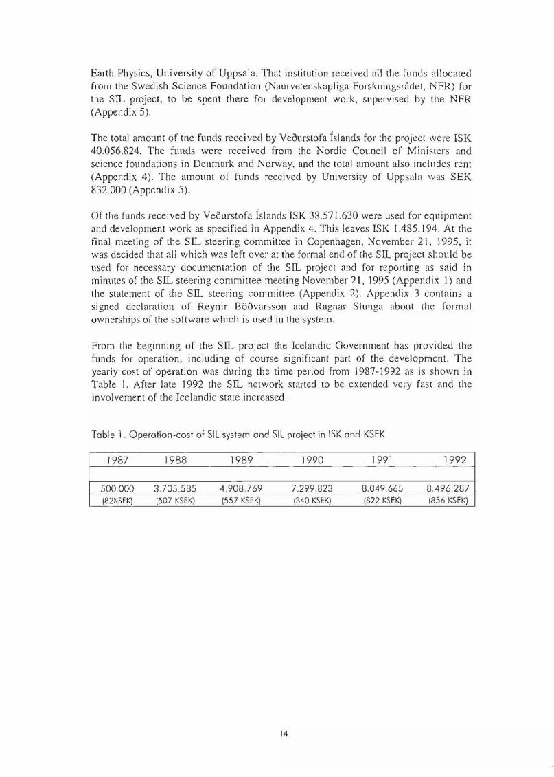
From the beginning of the SIL project the Icelandic Government has provided thefunds for operation, including of course significant part of the development. Theyearly cost of operation \Vas during the time period from 1987-1992 as is shown inTable I. After late 1992 the SIL network started to be extended very fast and theinvolvement of the Icelandic state increased.
Table 1. Operatian-cast of SIL system and SIL project in ISK and KSEK
1987 1988 1989 1990 1991 1992
500.000 3705585 4.908769 7299.823 8.049.665 8.496.287(82KSEK] (507 KSEK) (557 KSEK) (340 KSEK] (822 KSEKI (856 KSEK)
14
7 List of publications related to the SIL project or based onSIL data
Atakan, K., B. Brandsd6ttir, P. Halld6rsson & 0.6. Frioleifsson 1995a. Somecomments on the local site effects: A case study from Iceland. In: Abstracts from the18th European Regional Earthquake Engineering Seminar, September 4-8, 1995,Lyon, France.
Atakan, K., B. Brandsd6ttir, P. Halld6rsson & 0.6. Frioleifsson 1995b. Effects oflocal geology on seismic records: A case study in the South Iceland seismic zone (inpreparation).
Ågustsson, K. 1994. Volumetric strain measurements in southern Iceland, January1990 - November 1993. In: Abstracts from the NorFa workshop Earthquake predictionresearch in the South Iceland test area: State-of-the-art, January 4-7, 1994. VeourstofaIslands.
Ågustsson, K. & R. Stefansson 1992. The eruption of Hekla and its relation to strainrelease in southern Iceland. In: Abstracts from the 20th Nordie Oeological WinterMeeting, 7-] OJanuary, Reykjavik. The Icelandic Geoscience Society, The Faculty ofScience - University of Iceland.
Ågiistsson, K., A.T. Linde & R. Stefansson 1993. The Hekla (Iceland) 1991 eruption:Continuous strain data require a compound source mode!. In: Abstracts from the AGUSpring Meeting, May 24-28, Baltimore, Maryland.
Bjornsson, G. & S.Th. Rognvaldsson 1995. Uppttik jaroskjalfta a Hengilssvæoi arin1992-1994 (Epicentral distribution of earthquakes in the Hengill area 1992-1994).National Energy Authority, Reykjavik. In Icelandic.
Boovarsson, R. 1988a. Design of the data acquisition system for the South IcelandicLowland (SIL) project. Veourstofa Islands.
Boovarsson, R. 1988b. Short description of a layered data network. VeourstofaIslands.
Boovarsson, R. 1988c. SIL project. Status report. Veourstofa Islands.
Boovarsson, R. 1989a. Status of the SIL-data acquisition system. In: Abstracts fromthe 20th Nordic Seminar on Detection Seismology, 26-28 September, Sunne.
Boovarsson, R. 1989b. SIL data acquisition system. Status report. Veourstofa Islands.
Boovarsson, R. 1991 a. The SIL system, a new tool for earthquake acquisition. In:Abstracts from the 22nd NOI'dic Seminar on Detection Seismology, Hverageroi,Iceland, June 9-11, 1991. Veourstofa Islands.
15
Boovarsson, R. 1991 b. Possible future development of the SIL system. In: Abstractsfrom the 22nd Nordie Seminar on Detection Seismology, Hverageroi, Iceland, June 9Il, 1991. Veourstofa Islands.
Biiovarsson, R. 1991 c. The SIL system, a new tool for earthquake acquisition. In:Abstracts from the AGU Fall Meeting, December 9-13, 1991, San Francisco,California.
Biiovarsson, R. 1991 d. The SIL project. SIL reference manual.
Boovarsson, R. 1992a. The SIL system, a new tool for earthquake acquisition. In:Abstracts from the 20th Nordic Geological Winter Meeting, 7-10 January, Reykjavik.The Icelandic Geoscience Society, The Faculty of Science - University of Iceland.
Boovarsson, R. 1992b. A manual for an alert system. Veoustofa Islands.
Boovarsson, R. 1993. Artificia! neural networks and genetic algorithms: Basic theoryand some seismological applications. In: Abstracts from the 24th Nordic Seminar onDetection Seismology, June 16-18, 1993. University of Bergen.
BiiOvarsson, R. I994a. The SIL-data acquisition anc! the monitoring system. In:Abstracts from the NorFa workshop Earthquake prediction research in the SouthIceland test area: State-of-the-art, January 4-7, 1994. Veourstofa Islands.
Biiovarsson, R. 1994b. Application of genetic algorithms in the SIL project. In:Abstracts from the 25th Nordic Seminar on Detection Seismology, Stockholm,Swec!en, August 23-25. National Defence Research Establishment.
Biiovarsson, R. l994c. The Icelandic seismic network for monitoring, automaticevaluation anc! alerts. In: Abstracts from the workshop Monitoring and research formitigating seismic anc! vo!canic risk, October 20-22, 1994. Icelanc!ic MeteorologicalOffice and Commission of the European Communities, Directorate General XIIID-2,Science, Research and Development.
BiiOvarsson, R. 1995. The use of artificial neural network anc! genetic algorithms inthe South Iceland Lowland (SIL) project. In: Abstracts from the XXI ruGG GeneralAssembly, Boulc!er, Colorado, July 2-14,1995.
Biiovarsson, R. 1996. The Icelandic seismic network for monitoring, automaticevaluation anc! alerts. In: B. porkelsson & M. Yeroyanni (editors), Seismic andvolcanic risk, Proceec!ings of the workshop on Monitoring anc! research for mitigatingseismic and vo!canic risk, Reykjavik, Iceland, 20-22 October 1994. EuropeanCommission, Environment anc! Climate Programme.
BiiOvarsson, R. & R. Slunga 1988. Multistation analysis at the central computer. SILreport. Veourstofa Islanc!s.
BiiOvarsson, R. & S. Jakobsd6ttir 1989. SIL prototype station at Bjarnastaoir. Statusreport. Veourstofa Islanc!s.
16
Boovarsson, R. & R. Slunga 1989. Discussion of the detector- and selector functions.SIL report. Veourstofa Islands.
Boilvarsson, R. & S.Th. Rognvaldsson 1992. The SIL acquisition system, a new toolfor earthquake prediction research. Proceedings of the International Conference onPreparedness and Mitigation for Naturai Disasters 28-29 May, 1992, ReykjavIkIceland.
Boilvarsson, R., S. Jakobsd6ttir & R. Stefansson 1992. Seismological network withno waveform data transfer. In: Abstracts from the 23rd Nordic Seminar on DetectionSeismoJogy, Espoo, Finland, 2-4 September, 1992. Institute of Seismology, Universityof Helsinki.
Boovarsson, R., R. Slunga, STh. Rognvaldsson & R.G. Roberts 1992. Evaluation andoptimization of the SIL data analysis. SIL research proposal. Veilurstofa Islands.
Boilvarsson, R., R. Slunga & S.Th. Rognvaldsson 1993. Update and documentation ofthe SIL software. SIL research proposal. Veilustofa Islands.
Boovarsson, R., R. Slunga, S.Th. Rognvaldsson & R. Roberts 1993. Evaluation andoptimization of the SIL data analysis. Status report. Veilustofa Islands.
Boovarsson, R., S. Jakobsd6ttir & R. Stefansson I994a. The SIL data acquisition andmonitoring system. In: Abstracts from the 25th Nordic Seminar on DetectionSeismology, Stockholm, Sweden, August 23-25. National Defence ResearchEstablishment.
Boilvarsson, R., S. Jakobsd6ttir & R. Stefansson 1994b. The SIL data acquisition andthe monitoring system. In: Abstracts from the XXIV ESC General Assembly,September 19-24, 1994, Athens, Greece. University of Athens.
Boovarsson, R., R. Slunga, STh. Rognvaldsson & R. Roberts 1994. Evaluation andoptimization of the SIL data analysis and update and documentation of the SILsoftware. Status report. Veilurstofa Islands.
Boovarsson, R., S.Th .. Rognvaldsson, S. Jakobsd6ttir & R. Stefånsson 1995. The SILsystem, present status, ongoing development and the futme. In: Abstracts from the26th Nordic Seminar on Detection Seismology, National Survey and Cadastre,Denmark, November 20-22, 1995. Kort & Matrikelstyrelsen.
Boilvarsson, R., S.Th. Rognvaldsson, S. Jakobsd6ttir, R. Slunga & R. Stefånsson1995. The SIL data acquisition and monitoring system. In: Abstracts from the XXIlUGG General Assembly, Boulder, Colorado, July 2- 14, 1995.
Boilvarsson, R., STh. Rognvaldsson, S. Jakobsd6ttir, R. Slunga & R. Stefansson1996. The SIL data acquisition and monitoring system. Seism. Res. Lett. 67(5), 35-46.
Dahlmann, O. & L. Mendes-Victor 1983. Report of visit to the test zone of theLowland of South Iceland. European Council, special report. CAHRT 83(4),1-14.
17
Davidsson, M., K. Agustsson, R.T. Williams, l.S. Sacks, R. Stefansson & E.S.Robinson 1991. Precursors to the 17 January 1991 eruption of Hekla in the data fromareeording gravity meter. In: Abstracts from the AGU Fall Meeling, December 9-13,1991, San Francisco, California.
Department of Geophysics, Icelandic Meleorological Office 1994. [SIL-kerfio - HelstunioustOour ur SIL skjalftamælanetinu a Suourlandi). In: Eolisfræoi a islandi VII,Nesjåvollum, 8.-9. okt6ber, 1994. Dagskrå og ågrip. In Icelandic.
Guomundsson, G.B .. 1994. Epicenter distribution in and around the South Icelandseismic zone. In: Abstracts from the NorFa workshop Earthquake prediction researchin the South Iceland test area: State-of-lhe-art, January 4-7, 1994. Veourstofa islands.
Guomundsson, G.B. 1995. Manual for few SIL applications. Veourstofa islands.
Guomundsson, G.B. & R. Stefånsson 1995. Earthquake focal depth estimates from adense network in the South Iceland seismic zone. Veourstofa Islands.
Hu, G., W. Menke & S.Th. Ragnvaldsson 1993. A demonstration of the joint use of Pwave polarization and travel time data in tomographic inversion: Cmstal velocilystructure near the South Iceland Lowland network. Geophys. Res. Lett. 20, 14071410.
Husebye, E. 1988a. SIL project - event detection.
Husebye, E. 1988b. The SIL project - task inventory.
Jakobsd6ttir, S. 1989. Results of noise- and earthquake measurements obtained in theSIL-area. In: Abstracts from the 20th Nordic Seminar on Detection Seisl11ology, 2628. September, Sunne.
Jakobsd6ttir, S. 1990a. SIL-project, the first data records. In: Abstracts from the XXIIESC General Assembly, Barcelona, 17-22 September, 1990. Servei Geologic deCatalunya.
Jakobsd6ttir, S. 1990b. Some characteristics of the first recordings in the SIL-network.In: Abstracts from the 21 th Nordic Seminar on Detection Seismology, October 1-3,Copenhagen, 1990. Kort & Matrikelstyrelsen.
Jakobsd6ttir, S. 1991a. The SIL system: Phase detector - parameter data. In: Abstractsfrom the 22nd Nordic Seminar on Detection Seismology, Hverageroi, Iceland, June 9Il, 1991. Veourstofa Islands.
Jakobsd6ttir, S. 1991 b. The overall performance of the SIL network. In: Abstraetsfrom the AGU Fall Meeting, December 9-13,1991, San Francisco, California.
Jakobsd6ttir, S. 1992. The overall performance of the SIL-network. In: Abstracts fromthe 20th NOl·dic Geological Winter Meeting, 7-10 January, Reykjavik. The IcelandicGeoscience Society, The Faculty of Science - University of lceland.
18
Jakobsd6ttir, S. I994a. The overall performance of the SIL system. In: Abstract fromthe NorFa workshop Earlhguake prediction research in lhe Soulh Iceland lest area:State-of-the-art, January 4-7, 1994. Veourstofa Islands.
Jakobsd6ttir, S. 1994b. Some aspects of the SIL-system and its extension to the northof Iceland. In: Abstracts from the 25th Nordic Seminar on Detection Seismology,Stockholm, Sweden, August 23-25. National Defence Research Establishment.
Jakobsd6ttir, S. 1994c. The deteclability of the SIL earthguake monitoring system andthe seismicity in Icelancl as seen by it. In: Abstracts from the XXIV ESC GeneralAssembly, September 19-24, 1994, Athens, Greece. University of Athens.
Jakobsd6ttir, S. I994d. Ongoing projecls for earthguake precliction research inIceland. In: Abstracts from the workshop Monitoring and research for mitigatingseismic and vo1canic risk, October 20-22, 1994. Icelandic Meteorological Office andCommission of the European Communities, Directorate General XI1ID-2, Science,Research and Development.
Jakobsd6ttir. S. 1996. Ongoing projects for earlhguake prediclion research in Iceland.In: B. porkelsson & M. Yeroyanni (editors), Seismic and vo1canic risk, Proceedings ofthe workshop on Monitoring and research for mitigating seismic and vo1canic risk,Reykjavik, Iceland, 20-22 October 1994. European Commission, Environment andClimate Programme.
Jakobsd6ttir, S. & R. Stefånsson 1988. The vaults. Status report. Veourstofa Islands.
Jakobsd6ttir, S. & R. BOilvarsson 1991: Can Icelandic scientists predict earthguakes?News from Iceland, June 1991, 6B.
Jakobsd6ttir, S., R. Boovarsson & R. Stefansson 1992. The overall performance of theSIL-network in South Iceland Lowland. In: Abstracts from the 23rd Nordic Seminaron Detection Seismology, Espoo, Finland, 2-4 September, 1992. Institute ofSeismology, University of Helsinki.
Jakobsd6ttir S. & R. BOilvarsson 1993. The evaluation and optimization of the SILdata analyzes. In: Abstracts from the 24th Nm'dic Seminar on Detection Seismology,June 16-18, 1993. University of Bergen.
Jakobsd6ttir, S. & G. GuomundssonVeourstofu Islands. SIL-netio. In: P.Råostefna Eolisfræoifelags IslandsEolisfræoifelag Islands. In Icelandic.
1994. Jaroskjålftamælingar JaroeOlissviosArason (editor), Eolisfræoi å Islandi VII.a Nesjavollum, 8.-9. okt6ber, 1994.
Jakobsd6ttir, S. & F. Scherbaum 1995. Effects of the acausal response of zero phaseFIR filters on the onset time determination of P waves for inlennediate and bigearthquakes. In: Abstracts from the 26th Nm'dic Seminar on Detection Seismology,National Survey and Cadastre, Demnark, November 20-22, 1995. Kort &MatrikeIstyrelsen.
19
Linde, AT., S. Sacks, R. Stefansson & K. Ågustsson 199 I. The mechanism of the1991 Hekla, South Iceland eruption from borehole strainmeter data. In: Abstracts fromthe AGU FaJl Meeting, December 9-13, 1991, San Francisco, California.
Linele, A., K. Ågustsson, l.S. Sacks & R. Stefansson 1993. Mechanism of the 1991eruption of Hekla from continuous borehole strain monitoring. Nalllre 365,737-740.
Linele A., S. Sacks & K. Ågustsson 1994. Borehole strain measurements in southernIcelanel. In: Abstracts from the NorFa workshop Earthguake preeliction research in theSouth Iceland test area: State-of-the-art, January 4-7, 1994. Veourstofa Islands.
Menke, W. & V. Levin 1994. Colel crust in a hot spot. Geophys. Res. Lett. 21,19671970.
Menke, W., G. Hu & STh. Rognvaldsson 1994. Cmstal structure in the South Icelandseismic zone eletermined through the inversion of P wave azimulh and travel-timeanomalies. In: Abstracts from the NorFa workshop Earthguake preeliction research inthe South Iceland test area: State-of-the-art, January 4-7, 1994. Veourstofa Islanels.
Menke, W., B. Brandsd6uir, S. Jakobsd6ttir & R. Stefansson I994a. Seismicanisotrophy in the crust at the mid-Atlantic plate bounelary in South Iceland. In:Abstracts from the NorFa workshop Earthguake prediction research in the SouthIceland test area: State-of-the-art, January 4-7,1994. Veourstofa Islands.
Menke, W., B. Brandsel6uir, S. Jakobsd6ttir & R. Stefansson 1994b. Seismicanisotrophy in the crust at the mid-Atlantic plate boundary in South-West Icelanel.Geophys. J. Int. 119,783-790.
Menke, W., V. Levin & R. Sethi 1995. Seismic attenuation in the crust at the midAtlantic plate boundary in South-West Iceland. Geophys. J. Int. 122, 175-182.
Olafsson, S. 1990. Operation of the SIL system. Report. Veourstofa Islands.
Roberts, R., G. Lindfors, A. Christoffersson, R. Boovarsson & STh. Rognvaldsson1993. Three-component elata as an aid to seismic event eletection anel association: Acase study using data from the SIL (Icelanel) network. Computers and Geosciences19(2),123-134.
Rognvaldsson, STh. 1991. SIL project. 3-dimensional presentation of focalparameters. SIL research report, August 1991. Veourstofa Islands.
Rognvaldsson, S.Th. 1992. Fault plane solutions by combined use of polarities anelbody wave amplitudes. Dissertation for licentiate degree, Uppsala University.
Rognvaldsson, STh. 1993. A geometrical spreading function for South Icelanel. TheSIL project - achievements and fu ture prospects. In: Abstracts from the 24th Nm'dicSeminar on Detection Seismology, June 16-18, 1993. University of Bergen.
20
Ragnvaldsson, S.Th. 1994. Microearthquakes in South Iceland, fault plane solutionsand relative locations. PhD thesis, Uppsala University, ISSN lI04-232X.
Rognvaldsson, S.Th. & R. Slunga 1991. Fault plane solutions using amplitudeobservations - a test with synthetic seismograms. In: Abstracts from the 22nd NordicSeminar on Detection Seismology, Hveragerai, Iceland, June 9-1 I, 1991. VeourstofaIslands.
Ragnvaldsson, S.Th., R. Slunga & R. Boovarsson 1992. Evaluation and optimizationof the SIL data analysis. Present status. Veourstofa Islands.
Rognvaldsson, STh. & R. Slunga 1993. Routine fault plane solutions for localnetworks: A test with synlhetic data. Bull. Seism. Soc. Am. 83(4),1232-1247.
Ragnvaldsson, STh. & R. Slunga I994a. Single and joint fault plane solutions formicroearthquakes in South Iceland. Tectonophysics 237, 73-86.
Ragnvaldsson, STh. & R. Slunga 1994b. Relative location techniques applied to SILdata-preliminary results. In: Abstracts from the NorFa workshop Earthquakeprediction research in the South Iceland test area: State-of-the-art, January 4-7, 1994.Veourstofa Islands.
Rognvaldsson, S.Th. & G. Bjornsson 1995. Upptakagreining snu\skjalfta aNesjavollum i arsbyrjun 1995 (Microearthquakes near the Nesjavellir geothermal fieldin the first months of 1995). Report, OS-95034/JHD-05, National Energy Authority,Reykjavik. In Icelandic with English summary.
Ragnvaldsson, S.Th., R. Boovarsson, R. Slunga & S. Jakobsd6ttir 1995. The transferfunction of the SIL seismic data acquisition system. Technical report. VeourstofaIslands.
Ragnvaldsson, STh., R. Slunga, P. Einarsson & R. Stefansson 1995. Mapping activefaults in the Tjornes fracture zone, Iceland. In: Abstracts from the 26th NordicSeminar on Detection Seismology, National Survey and Cadastre, Denmark,November 20-22, 1995. Kort & Matrikelstyrelsen.
Shimamura, H., R. Stefansson, T. Watanabe, G.B. Guomundsson, P. Einarsson, S.Kodaira & H. Shiobara 1994. An extremely narrow zone of seismicity along the crestof the Reykjanes Ridge revealed by a dense ocean bottom seismographic survey. In:Abstracts from the 27th General Assembly of IASPEI, Wellington, New Zealand,January 10-21, 1994.
Slunga, R. 1988. Scientific objectives of the seismic data acquisilion system for thelowland of southern Iceland. Veourstofa Islands.
Slunga, R. 1991 a. The SIL report. Implemenlation of software for earthquake analysisin the SIL system. Veourstofa Islands.
21
Slunga, R. 1991 b. The SIL center automatic selection and event analysis. In: Abstractsfrom the 22nd Nordic Seminar on Detection Seismology, Hverageroi, Iceland, lune 9Il, 1991. Veourstofa Islands.
Slunga, R. 1991 c. Experiences of the earthquake analysis implel11ented at the SIL(South Iceland Lowland) seismic network. In: Abstracts from the 22ml NOl'dicSeminar on Detection Seismology, Hverageroi, Iceland, lune 9-11, 1991. VeourstofaIslands.
Slunga, R. I994a. The seismological routine analysis of microearthquakesimplemented into the SIL-system. In: Abstracts from the NorFa workshop Earthquakeprediclion research in the South Iceland test area: Stale-of-lhe-arl, January 4-7, 1994.Veourstofa Islands.
Slunga, R. 1994b. Principles of the automatic multistation analysis of the SILnetwork. In: Abstracts from the 25th NOl'dic Seminar on Detection Seismology,Stockholm, Sweden, August 23-25. National Defence Research Establishment.
Slunga, R. 1994c. Search for subsurface faults and fault movement in the SouthIceland seismic zone. In: Abstracts from the workshop Monitoring and research formitigating seismic and vo!canic risk, October 20-22, 1994. Icelandic MeteorologicalOffice and Commission of the European Communities, Directorate General XIIID-2,Science, Research and Development.
Slunga, R., S.Th. Rognvaldsson & R. Boovarsson 1994a. Absolute and relativelocations of similar events with application to microearthquakes in South Iceland. In:Abstracts from the 25th Nordic Seminar on Detection Seismology, Stockholm,Sweden, August 23-25. National Defence Research Establishment.
Slunga, R., S.Th. Rognvaldsson & R. Boovarsson 1994b. Absolute and relativelocations of similar events with application to microearthquakes in South Iceland.Geophys. J. Int. 123,409-419.
Slunga, R. 1996. Search for subsurface faults and fault movements in the SouthIceland seismic zone. In: B. Porkelsson & M. Yeroyanni (edi tors), Seismic andvo!canic risk, Proceedings of the workshop on Monitoring and research for mitigatingseismic and volcanic risk, Reykjavik, Iceland, 20-22 October, 1994. EuropeanCommission, Environment and Climate Programme.
Stefansson, R. 1988a. Seismomeler selection, a short overview. Veourstofa Islands.
Stefansson, R. 1988b. Report on the activities of the executive committee of the SILprojecl, October 3, 1987 - October 6, 1988. Veourstofa Islands.
Stefansson, R. 1988c. Report on the activities of the executive committee of the SILproject. Veourstofa Islands.
Stefansson, R. 1989a. SIL-projektet, en oversikt. Veourstofa Islands. In Swedish.
22
Stefansson, R. 1989b. SIL project. An activity report Oktober, 1988 - September,1989. Veourstofa Islands.
Stefansson, R. 1989c. SIL-research plan. In: Abstracts from the 20th Nordic Seminaron Detection Seismology, 26-28 September, Sunne.
Stefansson, R. 1990a. SIL-project, scientific background. In: Abstracts from the XXIIESC General Assembly, Barcelona, 17-22 September, 1990. Servei Geologic deCatalunya.
Stefansson, R. 1990b. SIL related research. In: Abstracts from the 21 th NordicSeminar on Detection Seismology, October 1-3, Copenhagen, 1990. Kort &Matrikelstyrelsen.
Stefansson, R. 1990c. SIL project. Report, October 3, 1990. Veourstofa Islands.
Stefånsson, R. 1991 a. SIL project. Report, February 1991. Veourstofa Islands.
Stefansson, R. 1991 b. SIL project. Report, June 1991. Veourstofa Islands.
Stefansson, R. 1991 c. SIL project. Report, November 5, 1991. Veourstofa Islands.
Stefansson, R. 1991d. The SIL project. Towards earthquake prediction in the SouthIceJand Lowland. In: Abstracts from the AGU Fall Meeting, December 9-13, 1991,San Francisco, California.
Stefansson, R. 1992a. Earthquake prediction and the Nordic SIL project. In: Abstractsfrom the 20th Nordic Geological Winter Meeting, 7-10 January, Reykjavik. TheIcelandic Geoscience Society, The Faculty of Science - University of Iceland.
Slefansson, R. 1992b. SIL project. Report, March 18, 1992. Veourstofa Islands.
Stefansson, R. 1992c. Earthquake prediction research in southern Iceland. A CECresearch proposal. An Environment Project, Area IV.I.I., Seismic Hazard.
Stefansson, R. 1992d. SIL project. Report, August 1992. Veourstofa Islands.
Stefansson, R. l992e. Earthquake prediction in the South Iceland seismic zone - alarge scale laboratory experiment. In: Abstracts from the 23rd Nm·dic Seminar onDetection Seismology, Espoo, Finland, 2-4 September, 1992. Institute of Seismology,Uni versity of Helsinki.
Stefansson, R. 1993a. SIL project. Report, March 1993. Veourstofa Islands.
Stefansson, R. 1993b. The SIL project - achievements and future prospects. In:Abstracts from the 24th Nm·dic Seminar on Detection Seismology, June 16-18, 1993.University of Bergen.
23
Stefansson, R. 1993c. Earthquake prediction research in southern Iceland. A CECresearch proposal. An Environment Project, Area IV.l.I., Seismic Hazarel.
Stefansson, R. I994a. SIL project. Report, August 1994. Veilurstofa Islands.
Stefansson, R. I994b. Iceland mantle plume tectonics. In: Abstracts from theworkshop Monitoring and research for mitigating seismic and vo1canic risk, October20-22, 1994. Icelandic Meteorological Office and Commission of the EuropeanCommunities, Directorate General XII/D-2, Science, Research and Developlllent.
Stefansson, R. 1995. Earthquake-prediction research in a naturai laboratory. Anapplication to the European Comlllission, Environment and Climate 1994-1998.Icelanelic Meteorological Office.
Stefansson, R. 1996a. Iceland plullle tectonics. In: B. l>orkelsson & M. Yeroyanni(editors), Seismic anel vo1canic risk, Proceedings of the workshop on Monitoring andresearch for mitigating seismic and vo1canic risk, Reykjavik, Icelanel, 20-22 October,1994. European Commission, Environment anel Climate Programme.
Stefansson, R. I996b. Iceland plume tectonics. In: Annales Geophysicae, abstractsfrom the XXI General Assembly of the European Geophysical Society, The Hague,May 6-10, 1996.
Stefansson, R., H. Bungulll, R. Bbilvarsson, J. Hjelme, E. Husebye, H. Johansen, H.KOl'honen & R. Slunga 1986. Seismiskt datasamlingssystem fOr Sbdra IslandsLågland. Noreliskt samarbete som syftar till att reducera skaelor i jordbaviningar oehatt kunna fOrutsiiga dem. Veilurstofa Islands. Partiy in Swedish.
Stefansson, R. & S. Jakobsd6ttir 1988. Field recordings, noise studies. VeilurstofaIslands.
Stefansson, R., R. Bbilvarsson & J. Hjelme 1989. The SIL-projeet. The second generalreport. Veilurstofa Islands.
Stefansson, R., R. Bbilvarsson, S. Jakobsd6ttir & S. Olafsson 1990. SIL projeet.Report, October 3, 1990. Veilurstofa Islands.
Stefansson, R. & K. Agustsson 1991. The Hekla eruption of 1991 and release of stressin the South Iceland seismic zone. In: Abstracts from the nnd Nordie Seminar onDetection Seismology, Hveragerili, Iceland, June 9-11, 1991. Veilurstofa Islands.
Stefansson, R. & R. Boovarsson 1991. The SIL project. Background and perspectivesfor earthquake preeliction in South Iceland Lowlanel. In: Scientific-TeehniealProeeedings of the Council of Europe International Conferenee on EarthquakePrediction, Strasbourg, October 1991.
24
Stefansson, R., B. Porkelsson & S. Jakobsd6uir 1992. Earthquake prediction researchin the South Iceland Lowland and the Su.. system. Proceedings of the InternationalConference on Preparedness and Mitigation for Naturai Disasters, 28-29 May, 1992,Reykjavik, Iceland.
Stefansson, R., R. B60varsson, R. Slunga, P. Einarsson, S. Jakobsd6uir, H. Bungum,S. Gregersen, J. Havskov, J. Hjelme & H. Korhonen 1992. The SIL project,background and perspectives for earthquake prediction in the South Iceland seismiczone. Veourstofa Islands.
Stefansson, R. & G. Guomundsson 1993. The shape of the South Iceland seismic zonebased on su.. data. In: Abstracts from the 24th Nm'dic Seminar on DetectionSeismology, June 16-18, 1993. University of Bergen.
Stefansson, R., R. Boovarsson, R. Slunga, P. Einarsson, S. Jakobsd6uir, H. Bungum,S. Gregersen, J. Havskov, 1. Hjelme & H. Km-hanen 1993. Earthquake predictionresearch in the South Iceland seismic zone and the Su.. project. Bull. Seism. Soc. Am.83(3), 696-716.
Stefansson, R., K. Ågustsson & P. Halld6rsson I994a. Confirming and monitoring ofstrainwaves. In: Abstracts from the 25th Nm-dic Seminar on Detection Seismology,Stockholm, Sweden, August 23-25. National Defence Research Establishment.
Stefansson, R., K. Ågustsson & P. Halld6rsson I994b. Confirming and monitoring ofstrainwaves. In: Abstracts from the XXIV ESC General Assembly, September 19-24,1994, Athens, Greece. University of Athens.
Stefånsson, R., G.B. Guomundsson, & R. Slunga 1994. Depth of the brittle ductileboundary in the Icelandic crust. In: Abstracts from the 25th NOt'dic Seminar onDetection Seismology, Stockholm, Sweden, August 23-25. National DefenceResearch Establishment.
Stefansson, R., P. Halld6rsson & G.E. Guomundsson 1994. Some features of theseismicity of the South Iceland seismic zone; Relative location techniques applied toSu.. data-preliminary results. In: Abstracts from the NorFa workshop Earthquakeprediction research in the South Iceland test area: State-of-the-arr, January 4-7, 1994.Veourstofa Islands.
Stefansson, R., R. Boovarsson, R. Slunga & S. Jakobsd6ttir 1994. The Su.. projectapproach to earthquake prediction. In: Abstracts from the XXIV ESC GeneralAssembly, September 19-24, 1994, Athens, Greece. University of Athens.
Stefansson, R., R. Boovarsson, G. Guomundsson, S. Jakobsd6uir & R. Slunga 1994.Earthquake prediction research in southern Iceland. The scope of the project and someresults. In: Abstracts from the 27th General Assembly of IASPEI, Wellington, NewZealand, January 10-21, 1994.
25
Stefansson, R., R. Boovarsson, S. Jakobsd6ttir & R. SllInga 1995. The SIL earthquakeprediction project, main results. In: Abstracts from the XXI ruGG General Assembly,Boulder, Colorado, JlIly 2-14, 1995.
Stefansson, R., R. Boovarsson, S. Jakobsd6ttir, R. Slunga & S.Th. Rognvaldsson1995. The SIL earthquake prediction project, main results, or microearthquakes as atool for earthquake prediction. In: Abstracts from the 26th Nordie Seminar onDelection Seismo10gy, National Survey and Cadastre, Denmark, November 20-22,1995. Kort & Matrikelstyrelsen.
Vogfjoro, K.S. 1994a. Modeling SIL seismograms from local and teleseismicearthqllakes to obtain velocity and Q-structure of the erust and upper mantIe. In:Abstracts from the NorFa workshop Earthquake prediction researeh in the SouthIceland test area: State-of-the-art, January 4-7,1994. Veourstofa Islands.
Vogfjoro, K.S. 1994b. Short-period loeal wave propagation in South-West Iceland. In:Abstracts from the AGU Spring Meeting, May 23-27, Baltimore, Maryland.
Vogfjoro, K.S. I994c. Short-period local and regional wave propagation in Iceland.In: Abstraets from the 25th Nm·dic Seminar on Detection Seismology, Stockholm,Sweden, August 23-25. National Defence Research Establishment.
Vogfjoro, K.S. Use of secondary body phases in the SIL data swarms for determiningthe depth of earthquakes. Work in progress.
26
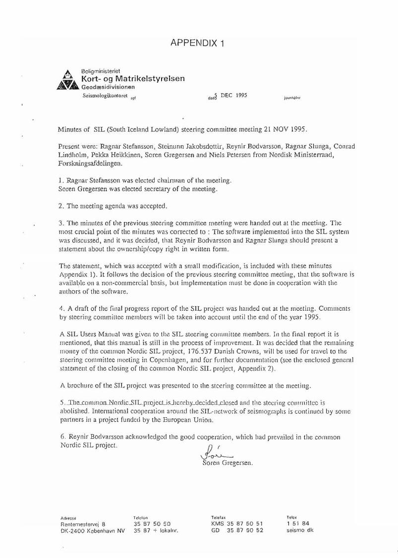
APPENDIX 1
A BoligministerietA_Å Kort- og MatrikelstyrelsenAT" Geodæsidivisionen
Scismologikontorel fcf .ola DEC 1995 jOllrlUJlnr
J~Safen Gregersen.
Minutes of SIL (Soulh Iceland Lowland) sleering commiltee lOeeting 21 NOV 1995.
Present were: Ragnar Stefansson, Steinunn Jakobsdottir, Reynir Bodvarsson, Ragnar Slunga, ConradLindholm, Pekka Heikkinen, Soren Gregersen and Niels Petersen from Nordisk Ministerraad,Forskningsafdelingen.
I. Ragnar Stefansson was elected chairman of the meeting.Soren Gregersen \Vas elected secretary of the meeting.
2. The lOeeting agenda \Vas accepted.
3. The minutes of the previous sleering committee meeting were handed out al the lOeeting. Themost crucial point of the minutes was corrected to : The software implemented into the SIL systemwas diseussed, and it was decided, that Reynir Bodvarsson and Ragnar Slunga should present astatement about thc ownership/copy right in wrilten fom1.
The statement, which was aeceptecl with a small modifieation, is included wilh these minutesAppendix l). It follows the deeision of the previous steering eommiltee meeting, that the software isavailable on a non-commercial basis, but implementation must be done in eooperalion with theauthors of the software.
4. A draft of the final progress report of the SIL project was handed out at the meeting. Commentsby steering eommittee members will be taken into account until the end of the year 1995.
A SIL Users Manual was given to the SIL steering commiltee members. In the final report it ismentioned, that this manual is still in the proeess of improvement. It was deeided that the remainingmoney of the com mon Nordic SIL project, 176.537 Danish Crowns, \Vill be used for travel to thesteering committee meeting in Copcnhagen, and for further documentation (see the enclosed generalstatement of the cIosing of the eommon Nordie SIL project, Appendix 2).
A brochure of the SIL projeet was presented to the stcering eOll1mittee at the meeting.
5 .-Ib"-ComlTIolLNordicSlL.pmjectJsJlereby_decided_closed and the steering eOll1miltec isabolished. International cooperation around thc SIL-nctwork of seismographs is continucd by somcpaJ1ners in a project funded by the European Union.
6. Reynir Bodvarsson acknowledged the good cooperation, whieh had prevailed in the commonNordic SIL projeet.
Adresse Te1cfon
Rentemestervej 8 35 87 50 50DK-2400 København NV 35 87 + løkalnr.
TeIeialt
KMS 35 87 50 51GD 35 87 50 52
Telex
l 51 84seismo dk
APPENDIX 2
IIpdatiog the SIT, software maOIlaI
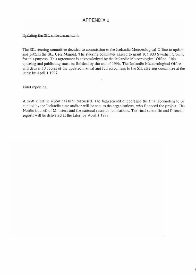
The SIL steering committee decided to commission to the Icelandic Meteorological Office to lIpdateand publish the SIL User Manual, The steering committee agreed to grant 103.800 Swedish Crownsfor this purpose. This agreement is acknowledged by the Icelandic Meteorological Office. Thisupdating and publishing must be fUlished by the end of 1996. The Icelandic Meteorological Officewill deliver 10 copies of the updated manual and full accounting to the SIL steering committee at thelatest by April I 1997.
A draft scientific report has been discussed. The final scientific report and the final accounting to bealldited by the Icelandic state audi tor will be sent to the organisations, who financed the project: TheNordic Council of Ministers and the national research foundations. The final scientific and financiaireports will be delivered at the latest by April I 1997.
APPENDIX 3
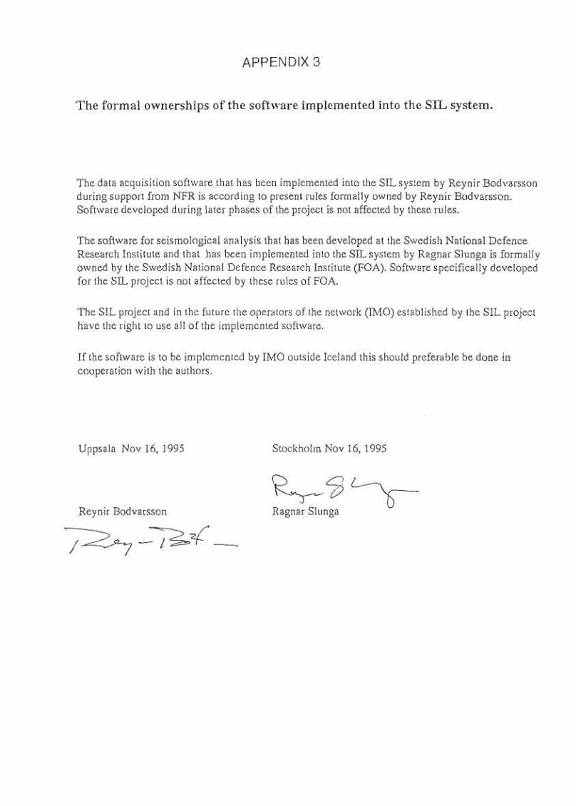
The formal ownerships of the software implemented into the SIL system.
The data acquisition software that has been implemented into the SIL system by Reynir Bodvarssonduring support from NFR is according to present rules forma liYowned by Reynir Bodvarsson.Software developed during later phases of the project is not affected by these rules.
The software for seismological analysis that has been developed at the Swedish National DefenceResearch Institute and that has been implemented into the SIL system by Ragnar Slunga is formallyowned by the Swedish National Defence Research Institute (FOA). Software specifically developedfor the SIL project is not affected by these rules of FOA.
The SIL project and in the future the opera tors of the network (IMO) established by the SIL projecthave the right to use all of the implemented software.
If the software is to be implemented by IMO outside Iceland this should preferable be done incooperation with the authors.
Uppsala Nov 16, 1995
Reynir Bodvarsson
Stockholm Nov 16, 1995
~?J~Ragnar Slunga
APPENDIX 4
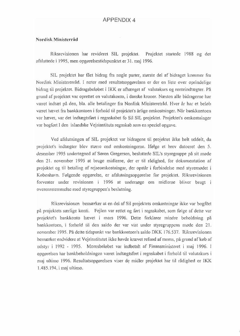
Nordisk Ministerråd
Riksrevisionen har revideret SIL projektet. Projektet startede 1988 og det
afsluttecle i 1995, men opgørelsestidspunktet er 3 I. maj 1996.,
SIL projektet har fået bidrag fra nogle parter, største del af bidraget kommer fra
Nordisk Ministererråd. I noter med resultatsopgørelsen er der en liste over oprindelige
bidrag til projektet. Bidragsbeløbet i IKK er afhænget af valutakurs og renteindtægter. På
grund af projektet var opreltet en valutakonto, i danske kroner. Næsten alle bidragerne har
været indsæt på den, bla. alle betalinger fra Nordisk Ministeretråd. Hver år har et beløb
været hævet fra bankkontoen i forhold til projektet's årlige omkostninger. Når bankkontoen
var hævet, var det indtægtsført i regnskabet fo Sil SIL projektet. Projektet's omkostninger
var bogført l den islandske Vejrisntituts regnskab som en speciel opgave.
Ved afslutningen af SIL projektet var bidragene til projektet ikke helt uddelt, da
projektet's indtægter blev større end omkostningerne. Ifølge et brev datoeret den 5.
desember 1995 undertegned af Søren Gregersen, besluttede SIL's styregruppe på sit møde
den 21. november 1995 at bruge midlerne, der er til rådighed, for dokumentation af
projektet og til betaling af rejseomkostningar, der opstår i forbindelse med styremødet i
København. Følgende opgørelse, er afslutningsopgørelse for projektet. Riksrevisionen
forventer under revisionen i 1996 at undersøge om midlerne bliver brugt i
overensstemmelse med styregruppen's beslutning.
Riksrevisionen bemærker at en del af Sil projektets omkostningar ikke var bogf6rt
på projektets særlige konti. Fejlen var reltet og ført i regnskabet, som følge af dette var
projektet's bankkonto hævet i mars 1996. Delte forklarer mindre beholdning på
bankkontoen, i forhold til den saldo der var vist under styregruppens møde den 21.
november 1995. På dette tidspunkt var bankkontoen's saldo DKK 176.537. Riksrevisionen
bemærker endvidere at Vejrinstitutet ikke havde krævet refund afmoms, på grund afkøb af
udstyr i 1992 - 1995. Momsbeløbet var indbetalt af Finansministeret i maj 1996. I
opgørelsen har bankbeholdningen været indtægtsført i regnskabet i forhold til valutakurs i
maj ultimo 1996. Resu1tatsopgørelsen viser de midler projektet har til rådighed er IKK
1.485.194, i maj ultimo.

Noter
1) På grund af projektet var oprettet en valutabankkonto, da alle bidragerne i DKK er
insæt på kontoen. Indtægtsposter (bidrag) i opgørelsen er i IKK. Det samme gælder når
bankkontoen er hævet til betalig af omkostninger. Som konsekvens er projektet's indtægter,
som består af er bidrag samt renteindtægter med kurssvingninger, summeret i en tal. På
opgørelsestidspunktet er bankbeholdning i DKK 69.968, indtægtsført med hensyn til
valutakurs maj ultimo 1996.
Den øverste tabell viser projketet's total intægter og den nedeste viser oprindelige bidrag
samt renteindtægter. Indtægtsført bidrag samt renteindtægter
Bidrag og renteindtægter
Indtægtsført på bankbeholdning 31.05.1996
lndtægter ialt
Oprinclelig bidrag samt renteindtægter
ordisk Ministerråd
Norges Almenvitenskabelige
Kort og MatrikastyreJsen
Geodædisk Institut
Kort og Matrikalstyrelsen
Renteti Iskrivning
39.263.602
793.222
40.056.824
3.000.000 DKK
322.587 DKK
113.466 DKK
485.333 IKK
884.127 IKK
514.465 DKK
2) Kontoen udstyr var bogført med moms total IKK 22.644.701, men momsbeløbet val'
refunderet IKK 2.092.219. Udstyret's nettobeløb er IKK 20.552.482.
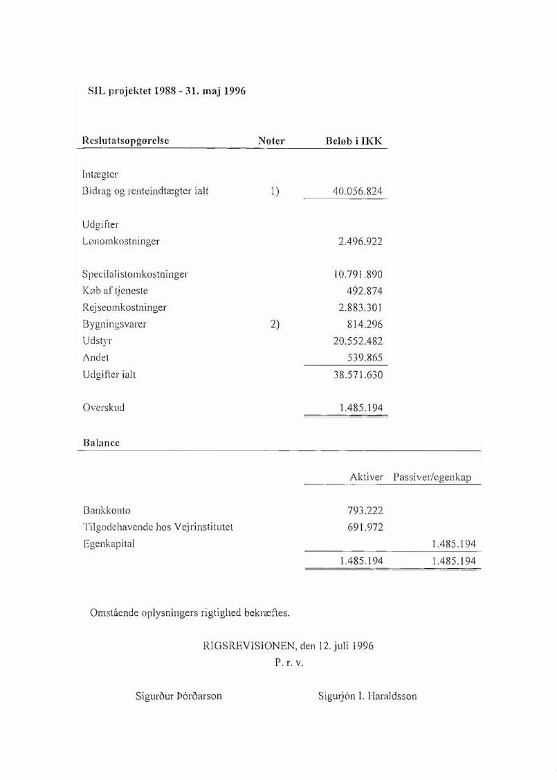
SIL projektet 1988 - 31. maj 1996
Resluta tsopgørelse
Intægter
Bidrag og renteindtægter ialt
Udgifter
Lønomkostninger
Speci IaIistomkostninger
Køb af tjeneste
Rejseomkostninger
Bygningsvarer
Udstyr
I\ndet
Udgifter ialt
Overskud
Balanee
Noter
1)
2)
Beløb i IKK
40.056.824
2.496.922
10.791.890
492.874
2.883.301
814.296
20.552.482
539.865
38.571.630
1.485.194
Aktiver Passiverlegenkap
Bankkonto
Tilgodehavende hos Vejrinstitutet
Egenkapital
Omstående oplysningers rigtighed bekræftes.
793.222
691.972
1.485.194
1.485.194
1.485.194
RlGSREVISIONEN, den 12. juli 1996
P. r. v.
Sigur5ur !>6r5arson Sigurjån l. Haraldsson
A•UPPSALA UNIVERSITET
InstilUtioDCD for geofysik
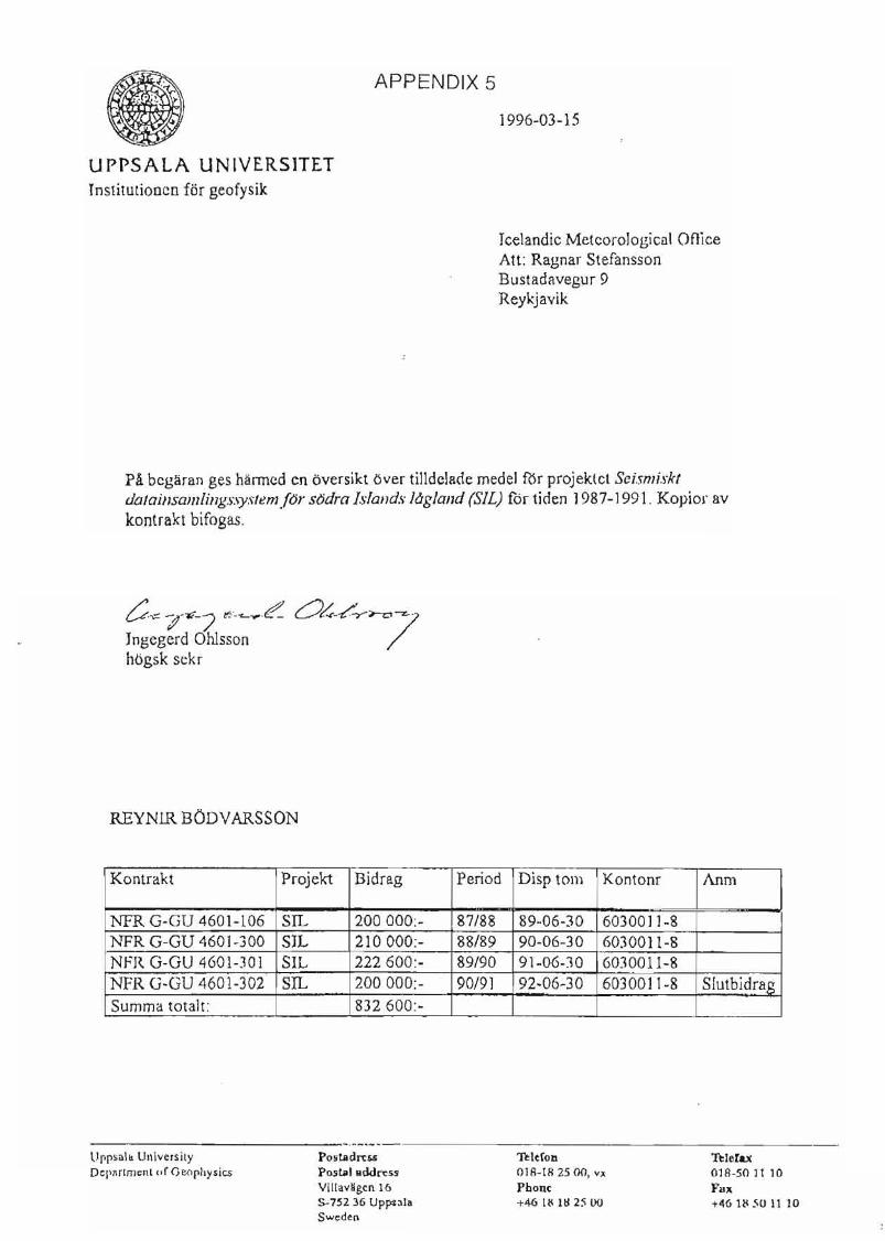
APPENDIX 5
1996-03-15
Icelandie Meteorologienl OflieeAtt: Rngnar StefanssonBustadavegur 9Reykjavik
P! bcgaran ges harrned en oversikt over tilldclacle medel RIr projektet Seismi.rktdatainsamlil1g.r:\ystem (or sodra lI-lal1d.\·låglal1d (SIL) fdr tiden 1987-1991. Kopior avkontrakt bifogas.
t:-.", -;;-7<-7 ",._~~e:- Oh-/-Y~7·Jngegerd Ohlssonhogsk sekr
REYNLR BODYARSSON
Kontrakt Projekt Bidrag Period Disp tom Kontonr Anm
NFR G·GU 4601-106 SIL 200000:- 87/88 89-06-30 603001 ]-8NFR G-GU 460]-300 SIL 210000:- 88/89 90-06-30 6030011-8NFR G-GU 4601-301 SIL 222600:- 89/90 91-06-30 6030011-8NFR G-GU 4601-302 SIL 200000:- 90/91 92-06-30 6030011-8 Slutbidrag
Summa totalt: 832600:-
Oppsal&. UniversityDcpl\rtmcnl of Geoph)lsics
P05"tiIdrt5SPostal ilddn:ssVillav"gcn 165-752 36 Uppn'aSweden
Teleron01A-18 25 00, V;(
PbODC+46 1~ U:~ 2~ 00
ThIefaxOla-50 lt 10Fa.+46 IN 501110