Embed Size (px)
Citation preview
North WestGreen
InfrastructureGuide
P R E P A R E D B Y T H E N O R T H W E S T G R E E N I N F R A S T R U C T U R E T H I N K T A N K
Version: 1.1
©Nat
ural
Eng
land
The North WestGreen InfrastructureThink Tank Partners:
CABE Space
Cass Associates
Cure
Environment Agency
Forestry Commission
Government Office North West
Green Space North West
Groundwork
Natural Economy North West
Natural England
North West Regional Assembly
Red Rose Forest
TEP
The Mersey Forest
University of Salford
Version: 1.1
INTRODUCTION
1.0 What is Green Infrastructure?
1.1 How it Works
1.2 Why is Green Infrastructure Planning Important?
1.3 Green Infrastructure Planning – the Process
1.4 What do you get at the end?
CO
NT
EN
TS
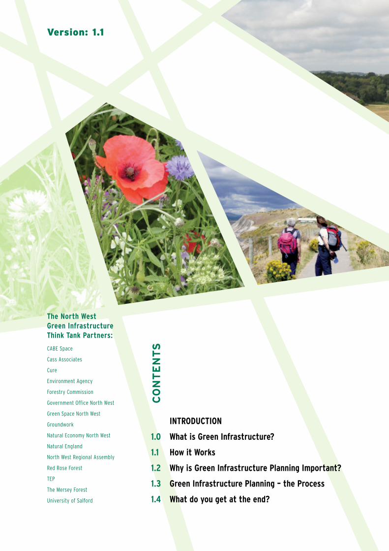
1.0 What is Green Infrastructure?
GREEN INFRASTRUCTURE IS THE REGION’S LIFE SUPPORT SYSTEM –
THE NETWORK OF NATURAL ENVIRONMENTAL COMPONENTS AND GREEN
AND BLUE SPACES THAT LIES WITHIN AND BETWEEN THE NORTH WEST’S
CITIES, TOWNS AND VILLAGES WHICH PROVIDES MULTIPLE SOCIAL,
ECONOMIC AND ENVIRONMENTAL BENEFITS.DE
FIN
ITIO
N
ComponentsIn the same way that a transport system is made up of a network of roads,rail, airports etc. green infrastructure has its own physical components.These include:
Hedges
Outdoor sports facilities Coastal habitat
Cemeteries, churchyards and burial groundsGrassland and Heathland
Allotments, community gardens and urban farmsAgricultural LandMoorland
Degraded LandOpen SpacesVillage GreensPrivate Gardens
ParksWildlife HabitatsPondsLakes
FieldsOpen CountrysideStreet TreesWoodlands
WaterwaysOpen Spaces
1.1 How it Works
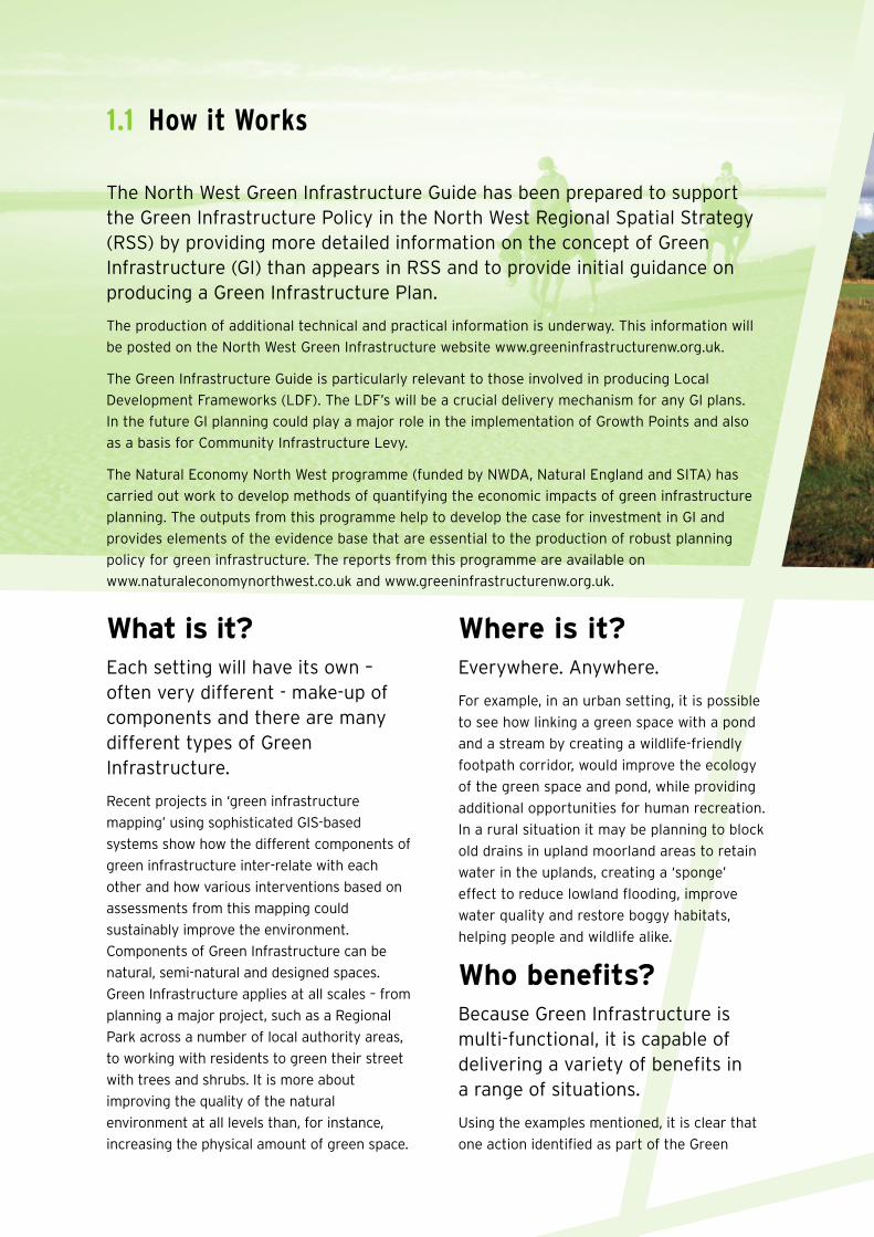
What is it?Each setting will have its own –often very different - make-up ofcomponents and there are manydifferent types of GreenInfrastructure.
Recent projects in ‘green infrastructure
mapping’ using sophisticated GIS-based
systems show how the different components of
green infrastructure inter-relate with each
other and how various interventions based on
assessments from this mapping could
sustainably improve the environment.
Components of Green Infrastructure can be
natural, semi-natural and designed spaces.
Green Infrastructure applies at all scales – from
planning a major project, such as a Regional
Park across a number of local authority areas,
to working with residents to green their street
with trees and shrubs. It is more about
improving the quality of the natural
environment at all levels than, for instance,
increasing the physical amount of green space.
Where is it?Everywhere. Anywhere.
For example, in an urban setting, it is possible
to see how linking a green space with a pond
and a stream by creating a wildlife-friendly
footpath corridor, would improve the ecology
of the green space and pond, while providing
additional opportunities for human recreation.
In a rural situation it may be planning to block
old drains in upland moorland areas to retain
water in the uplands, creating a ‘sponge’
effect to reduce lowland flooding, improve
water quality and restore boggy habitats,
helping people and wildlife alike.
Who benefits?Because Green Infrastructure ismulti-functional, it is capable ofdelivering a variety of benefits ina range of situations.
Using the examples mentioned, it is clear that
one action identified as part of the Green
The North West Green Infrastructure Guide has been prepared to supportthe Green Infrastructure Policy in the North West Regional Spatial Strategy(RSS) by providing more detailed information on the concept of GreenInfrastructure (GI) than appears in RSS and to provide initial guidance onproducing a Green Infrastructure Plan.
The production of additional technical and practical information is underway. This information will
be posted on the North West Green Infrastructure website www.greeninfrastructurenw.org.uk.
The Green Infrastructure Guide is particularly relevant to those involved in producing Local
Development Frameworks (LDF). The LDF’s will be a crucial delivery mechanism for any GI plans.
In the future GI planning could play a major role in the implementation of Growth Points and also
as a basis for Community Infrastructure Levy.
The Natural Economy North West programme (funded by NWDA, Natural England and SITA) has
carried out work to develop methods of quantifying the economic impacts of green infrastructure
planning. The outputs from this programme help to develop the case for investment in GI and
provides elements of the evidence base that are essential to the production of robust planning
policy for green infrastructure. The reports from this programme are available on
www.naturaleconomynorthwest.co.uk and www.greeninfrastructurenw.org.uk.
Infrastructure process can have multiple
benefits for people and wildlife. It is also a
flexible approach so if, for example, an area
became prone to flash flooding due to climate
change, a range of actions from physical
defences to water catchment changes to
planting appropriate trees or crops – or a
mixture of all of these – can be put into place
relatively quickly. It is also a tool for connecting
areas of fragmentation – it may be equally used
to increase the physical range of habitat for an
important species or ensure that sufficient
area is available to sustain a species.
Green Infrastructure can be planned to be close
to where people need it most – for example in
areas of high deprivation and ill health where it
can be a valuable contributor to improving
wellbeing. Good green infrastructure is of
considerable economic value too. A recent
CABE report ‘The Value of Public Space’ cites
many examples from around the world where
improvements in green infrastructure have
helped attract inward investment, increase local
house prices and drive up local economies.
1.2 Why is Green InfrastructurePlanning Important?
In the context of climate change,development pressure and a rapidlychanging business and agriculturallandscape, finding a joined-up andcross-regional approach to planningthe North West’s future GreenInfrastructure – our life supportsystem – is seen as crucial.
The built infrastructure upon which our
economy depends – which provides the
framework for future growth and development
– is planned in advance as a system of
interconnected parts. We owe the environment
the same consideration and should embrace
Green Infrastructure planning as the
framework for future land management.
The overall purpose of green infrastructure
planning is to answer the question: ‘How can
the North West’s natural environment be
conserved, improved and managed to deliver
the best social, economic and environmental
benefits for the region?’ It is a key AID to the
delivery of objectives that ALREADY exist at
regional, sub-regional and local level rather
than an additional Strategy.
The Green Infrastructure approach to planning
is important to anyone whose objectives relate
to, use, or draw upon the natural environment:
• Urban renaissance
• Rural renewal
• Social inclusion and community cohesion
• Health and wellbeing
• Sustainable development
Green Infrastructure is a core outcome of any
regeneration programme involving land or
water. As a planning tool, it is highly flexible
and therefore can apply to all of the region’s
different urban and rural settings.
In this Guide where the term ‘Planning’ is used it refers to Spatial Planning; ‘planning’ in the sense of activity is referred to as ‘project planning’
1.3 Green Infrastructure Planning – The Process
There are five basic steps to GreenInfrastructure Planning (these are
expanded upon in detail in Section 2).
1 Partnerships and Priorities
• Build partnerships of stakeholders who
benefit from, and lobby for, green
infrastructure
• Review relevant policies and strategies
• Determine the key outcomes for the
green infrastructure mapping process
• The Partnership determines the scope of
the plan based on resources, objectives
and information available
• Build organisational support for the Green
Infrastructure Plan
2 Data Audit and Resource Mapping
• Identify available information, including
maps, regional and national guidance,
datasets, relevant policy frameworks,
regional and national strategies and
stakeholders
• Generate a map of the physical area
showing green infrastructure types and
locations (usually on a GIS system)
3 Functional Assessment
• Assess current situation – what the green
infrastructure is doing, where it is
functioning well and needs to be
maintained, where it needs to be improved
• Assess future situation – what are the
threats to green infrastructure, where are
the opportunities for improvement, how it
might need to change, how to secure
change
4 Needs Assessment
• Cross-reference Green Infrastructure
planning with strategic outcomes identified
in Step 1
• ?Reference relevant datasets such as
deprivation indices, market research,
house prices etc
5 Intervention PlanThe Green InfrastructurePlan will set out:
• What the green infrastructure of an area is
• What it is doing and what it might do
• Where the green infrastructure is
functioning well and needs maintaining
• How it needs to change
• What will be done to secure change
The last two elements form the ‘Intervention
Plan’ which works out what changes need to
happen at what localities, when and by
which means. This will need to ensure that
positive environmental changes can be
made while taking into account a wide range
of related issues such as local character,
landscape and resources. It will also
determine the type of intervention required
– physical/policy, regulatory/incentive,
direct/indirect – or combination to achieve
the desired change.
A comprehensive, interactive andhighly flexible evidence base fora range of purposes:
• A framework for the sustainable
land management of the area
• A tool for predicting the implications
of change on the natural environment
• An accurate picture of the green
infrastructure of an area – essential in
making planning decisions, informing
developments and strategies
• A tool for delivering the natural
environmental contribution to identified
priorities in the fields of health,
economy and quality of life etc
• A structured plan for delivering
environmental change
• Attracting funding by demonstrating
researched needs and outcomes
• Attracting inward investment
1.4 What do you get at the end?
North WestGreen
InfrastructureGuide
Section 2
P R E P A R E D B Y T H E N O R T H W E S T G R E E N I N F R A S T R U C T U R E T H I N K T A N K
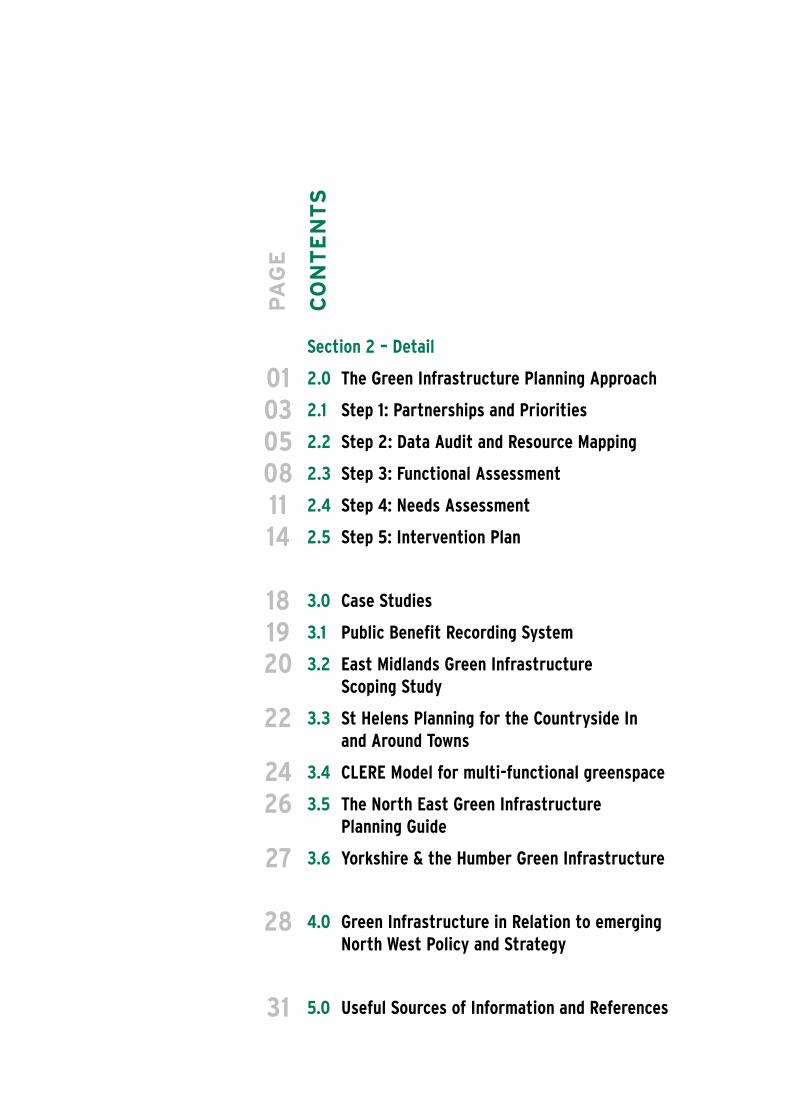
Section 2 – Detail
2.0 The Green Infrastructure Planning Approach
2.1 Step 1: Partnerships and Priorities
2.2 Step 2: Data Audit and Resource Mapping
2.3 Step 3: Functional Assessment
2.4 Step 4: Needs Assessment
2.5 Step 5: Intervention Plan
3.0 Case Studies
3.1 Public Benefit Recording System
3.2 East Midlands Green InfrastructureScoping Study
3.3 St Helens Planning for the Countryside Inand Around Towns
3.4 CLERE Model for multi-functional greenspace
3.5 The North East Green InfrastructurePlanning Guide
3.6 Yorkshire & the Humber Green Infrastructure
4.0 Green Infrastructure in Relation to emerging North West Policy and Strategy
5.0 Useful Sources of Information and References
CO
NT
EN
TS
PA
GE
010305081114
181920
22
2426
27
28
31
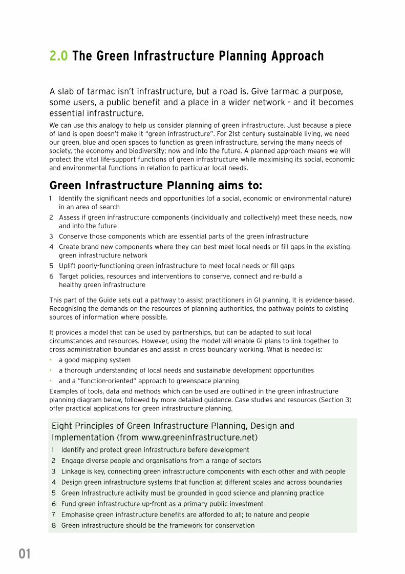
2.0 The Green Infrastructure Planning Approach
A slab of tarmac isn’t infrastructure, but a road is. Give tarmac a purpose,some users, a public benefit and a place in a wider network - and it becomesessential infrastructure.We can use this analogy to help us consider planning of green infrastructure. Just because a pieceof land is open doesn’t make it “green infrastructure”. For 21st century sustainable living, we needour green, blue and open spaces to function as green infrastructure, serving the many needs ofsociety, the economy and biodiversity; now and into the future. A planned approach means we willprotect the vital life-support functions of green infrastructure while maximising its social, economicand environmental functions in relation to particular local needs.
Green Infrastructure Planning aims to:1 Identify the significant needs and opportunities (of a social, economic or environmental nature)
in an area of search
2 Assess if green infrastructure components (individually and collectively) meet these needs, now and into the future
3 Conserve those components which are essential parts of the green infrastructure
4 Create brand new components where they can best meet local needs or fill gaps in the existing green infrastructure network
5 Uplift poorly-functioning green infrastructure to meet local needs or fill gaps
6 Target policies, resources and interventions to conserve, connect and re-build ahealthy green infrastructure
This part of the Guide sets out a pathway to assist practitioners in GI planning. It is evidence-based.Recognising the demands on the resources of planning authorities, the pathway points to existingsources of information where possible.
It provides a model that can be used by partnerships, but can be adapted to suit localcircumstances and resources. However, using the model will enable GI plans to link together tocross administration boundaries and assist in cross boundary working. What is needed is:
• a good mapping system
• a thorough understanding of local needs and sustainable development opportunities
• and a “function-oriented” approach to greenspace planning
Examples of tools, data and methods which can be used are outlined in the green infrastructureplanning diagram below, followed by more detailed guidance. Case studies and resources (Section 3)offer practical applications for green infrastructure planning.
01
Eight Principles of Green Infrastructure Planning, Design andImplementation (from www.greeninfrastructure.net)1 Identify and protect green infrastructure before development
2 Engage diverse people and organisations from a range of sectors
3 Linkage is key, connecting green infrastructure components with each other and with people
4 Design green infrastructure systems that function at different scales and across boundaries
5 Green Infrastructure activity must be grounded in good science and planning practice
6 Fund green infrastructure up-front as a primary public investment
7 Emphasise green infrastructure benefits are afforded to all; to nature and people
8 Green infrastructure should be the framework for conservation
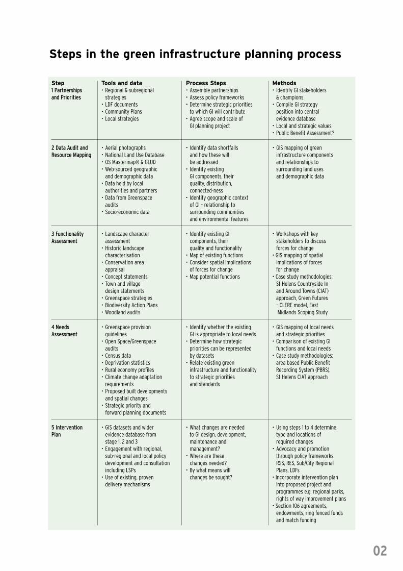
Step Tools and data Process Steps Methods1 Partnerships • Regional & subregional • Assemble partnerships • Identify GI stakeholdersand Priorities strategies • Assess policy frameworks & champions
• LDF documents • Determine strategic priorities • Compile GI strategy • Community Plans to which GI will contribute position into central• Local strategies • Agree scope and scale of evidence database
GI planning project • Local and strategic values• Public Benefit Assessment?
2 Data Audit and • Aerial photographs • Identify data shortfalls • GIS mapping of greenResource Mapping • National Land Use Database and how these will infrastructure components
• OS Mastermap® & GLUD be addressed and relationships to• Web-sourced geographic • Identify existing surrounding land uses
and demographic data GI components, their and demographic data• Data held by local quality, distribution,
authorities and partners connected-ness• Data from Greenspace • Identify geographic context
audits of GI – relationship to• Socio-economic data surrounding communities
and environmental features
3 Functionality • Landscape character • Identify existing GI • Workshops with keyAssessment assessment components, their stakeholders to discuss
• Historic landscape quality and functionality forces for changecharacterisation • Map of existing functions • GIS mapping of spatial
• Conservation area • Consider spatial implications implications of forcesappraisal of forces for change for change
• Concept statements • Map potential functions • Case study methodologies:• Town and village St Helens Countryside In
design statements and Around Towns (CIAT)• Greenspace strategies approach, Green Futures• Biodiversity Action Plans – CLERE model, East• Woodland audits Midlands Scoping Study
4 Needs • Greenspace provision • Identify whether the existing • GIS mapping of local needsAssessment guidelines GI is appropriate to local needs and strategic priorities
• Open Space/Greenspace • Determine how strategic • Comparison of existing GIaudits priorities can be represented functions and local needs
• Census data by datasets • Case study methodologies:• Deprivation statistics • Relate existing green area based Public Benefit• Rural economy profiles infrastructure and functionality Recording System (PBRS),• Climate change adaptation to strategic priorities St Helens CIAT approach
requirements and standards• Proposed built developments
and spatial changes• Strategic priority and
forward planning documents
5 Intervention • GIS datasets and wider • What changes are needed • Using steps 1 to 4 determinePlan evidence database from to GI design, development, type and locations of
stage 1, 2 and 3 maintenance and required changes• Engagement with regional, management? • Advocacy and promotion
sub-regional and local policy • Where are these through policy frameworks:development and consultation changes needed? RSS, RES, Sub/City Regionalincluding LSPs • By what means will Plans, LDFs
• Use of existing, proven changes be sought? • Incorporate intervention plandelivery mechanisms into proposed project and
programmes e.g. regional parks,rights of way improvement plans
• Section 106 agreements, endowments, ring fenced funds and match funding
Steps in the green infrastructure planning process
02
2.1 Step 1 – Partnerships and Priorities
The process of green infrastructure planning starts by establishing a clearunderstanding of the partnerships that are needed to plan and deliver greeninfrastructure in the area and the strategic social, economic andenvironmental priorities that apply to the area.
Building PartnershipsA healthy green infrastructure requires continuing input from private, public and voluntary sector
partners; including landowners and stakeholders representing the functions green infrastructure
serves – economic growth, social inclusion, community values and environmental sustainability.
Early stages of green infrastructure planning should bring together as wide a partnership as
possible in order to agree shared priorities, broker consensus and build a coalition for
implementation. Importantly it should not just be environmental organisations, but will bring
together professionals involved in social and economic regeneration and growth too.
Green infrastructure needs champions at regional, sub-regional and local levels. Champions will
define and promote a vision for green infrastructure and co-ordinate actions by partners. As key
contact points within their organisation or discipline, they will assist practitioners in getting to grips
with the green infrastructure concept and key policy requirements; and will assist with constraints
and operational issues they may face. Identifying, at an early stage, those individual or groups who
may be potential “blockers” to green infrastructure will also be beneficial.
The GI plan may be built up over several years, as resources allow, with particular immediate
needs being met either geographically (i.e. an area with obvious poor Green Infrastructure) or
thematically (i.e. the role that GI can play in improving the image of an area).
At regional and sub-regional level, partnerships will be strategic in nature, concerned with
championing cross-sector working, identifying the major building-blocks of green infrastructure,
horizon-scanning and securing support for implementation.
At local level, partnerships will focus on delivering positive change in the quantity, quality,
connectivity and functioning of the parcels of open space that form the green infrastructure for
their area. Local partnerships should, through consultation, understand how and why their
communities value green infrastructure. Statements of Community Involvement (prepared as part
of Local Development Frameworks) provide guidance on groups and organisations active in the area
and also types of consultation appropriate to different circumstances.
03
Assessment of policyframeworks and determinationof strategic prioritiesPriorities for green infrastructure planning will be
influenced by the partnerships and also by the
framework of social, economic and environmental
policies and strategies. As these evolve over time, it is
useful to retain policy and strategy information in one
place.
For St Helens (see Case Study) a central policy database
was built which listed all the relevant policies and related
the functions of green infrastructure to each policy – in
turn this allows intervention plans to explicitly deliver
those policies.
National, regional and sub-regional documents set the
ethos of green infrastructure planning and stimulate
strategic actions. The local context needs to supplement
this and should include Local Development Frameworks,
Community Plans, Local Strategic Partnerships and other
geographic or thematic strategies.
Strategies and policies should be examined in a
methodical and thorough way. The following questions
can be used as prompts:
• Does this policy aim to create new green infrastructure resources?
• Does this policy aim to change management of green infrastructure resources?
• Could this policy be delivered through improvements to the green infrastructure resource?
• Does this policy directly or indirectly link to one of the five key stages of green
infrastructure planning?
• Which green infrastructure functions (e.g. health, economic growth, habitat for wildlife)
does this policy seek to influence and provide?
During consultation on this guide, practitioners identified a number of documents which help to
define priorities for local and/or strategic action (see Section 5).
As well as being influenced by partnerships and policy, strategic priorities might also consider a
public benefit assessment or sustainability appraisal – this is perhaps more applicable to regional
or sub-regional planning. Such an appraisal helps practitioners identify the areas and/or
communities of the North West in deepest need of the multiple benefits that healthy green
infrastructure brings. A Case Study describes the Public Benefit Recording System (PBRS), an
approach that is promoted by Forestry Commission as an aid to investment in new environmental
resources.
04
St Helens Together, thenationally accredited LSP forSt Helens, brings together ata local level the public sectoras well as the private,business, community andvoluntary sectors allowingdifferent initiatives andservices to support eachother and work together.Operating at a level whichenables strategic decisions tobe taken and close enough toindividual neighbourhoods toallow actions to bedetermined at communitylevel, this LSP has beeninstrumental in aiding theSt Helens countryside in andaround towns plan shown asa Case Study in Section 3.
2.2 Step 2 – Data Audit and CurrentResource Mapping
This step requires checking and collating data sources that are needed toanalyse the existing green infrastructure resource and develop anintervention plan. Mapping the information allows the spatial extent, contextand character of the existing green infrastructure resource to be identified.
Assessment of dataAn initial understanding of the green infrastructure resource can be made through examination of
national datasets; supplemented by locally specific datasets. The choice of datasets will depend on
the strategic priorities, local circumstances and character of the area to be planned. Datasets
loosely fall into four categories:
• Land Use (e.g. Woodland, private garden, general amenity space)
• Land Cover (e.g. Improved grassland, broadleaf, saltmarsh)
• Environmental Value
• Demographic Patterns
The National Land Use Database (NLUD) and Land Use Change Statistics (LUCS) are available from
the Office of National Statistics (ONS). The Department for Communities and Local Government
(DCLG) holds the Generalised Land Use Database (GLUD). When used alongside OS Mastermap®,
current land use patterns and an initial estimate of the extent of the existing green infrastructure
resource can be determined.
ONS and DCLG also hold demographic datasets, such as the Index of Multiple Deprivation, 2004
(IMD), data on community health, skills and employment, and information about population density
– all factors which influence how green infrastructure is planned. The Audit Commission’s Area
Profiles include data on community perceptions of the public realm and the way greenspace is
managed and valued.
• www.statistics.gov.uk
• www.communities.gov.uk
• www.areaprofiles.audit-commission.gov.uk
A number of websites hold national level Geographical Information System (GIS) datasets. These
datasets can refine and add information to initial green infrastructure resource estimates, and can
begin to identify greenspace functionality. The websites provide datasets available for download
and signpost to other organisations who hold datasets.
• www.magic.gov.uk
• www.gigateway.org.uk
• www.landscapecharacter.org.uk
05
Other useful sources of green infrastructure datasets include:
Natural England UKBAP habitat areas, ecological frameworks, designated areas,
open access areas, landscape character, land management and
tenure data, uptake of Countryside / Environmental Stewardship
Environment Agency water resource management, flood risk, soils and other natural
resource management issues
English Heritage cultural heritage and archaeology
Sport England playing pitches and sports tracks
Forestry Commission woodland inventory
Local Authorities aerial photography, local environmental surveys and designations,
(District, County planning allocations, greenspace audits, and numerous other
and Unitary) locally specific information re socio-economic and environmental
conditions and priorities.
Community Forests, woodland planting and management, habitat creation and
countryside management management, accessible areas, reserves
initiatives, Woodland and
Wildlife Trusts
Much data on typology and function is already held by Local Authorities, often collected in previous
greenspace studies, for instance PPG17 appraisals and Greenspace Strategies or as part of the
development of Ecological Frameworks. Many Local Authorities have Citizens Panels whose views on the
public realm generally, and greenspaces in particular, will reflect local priorities. Such data, sometimes
subjective, is vital to include because it helps ensure the way the community values and interacts with
green infrastructure is considered; in turn building partnerships and adding delivery capacity.
When mapping is to occur across administrative boundaries, the availability and consistency of data
across boundaries is an important and/or limiting factor. In addition there may be legal restrictions
on the use of some datasets which will need to be overcome.
Data shortfallsGreen infrastructure planning should be a dynamic approach to natural environmental intervention
which reflects the changing needs of an area over time. Therefore whilst data shortfalls at the
outset will prevent a completely accurate assessment from being undertaken, additional data can
be incorporated into the intervention plan at a later stage. It is recommended that data used to
determine intervention should be revisited periodically in order to take advantage of new or
amended datasets, recently produced policy and strategy information, and additional stakeholders
who can contribute to the planning process.
In the assessment of data, the green infrastructure partnership should consider whether a stand
alone GI document is necessary or whether it can be incorporated into other policy/strategy
documents.
06
Identifying and mapping the greeninfrastructure resource
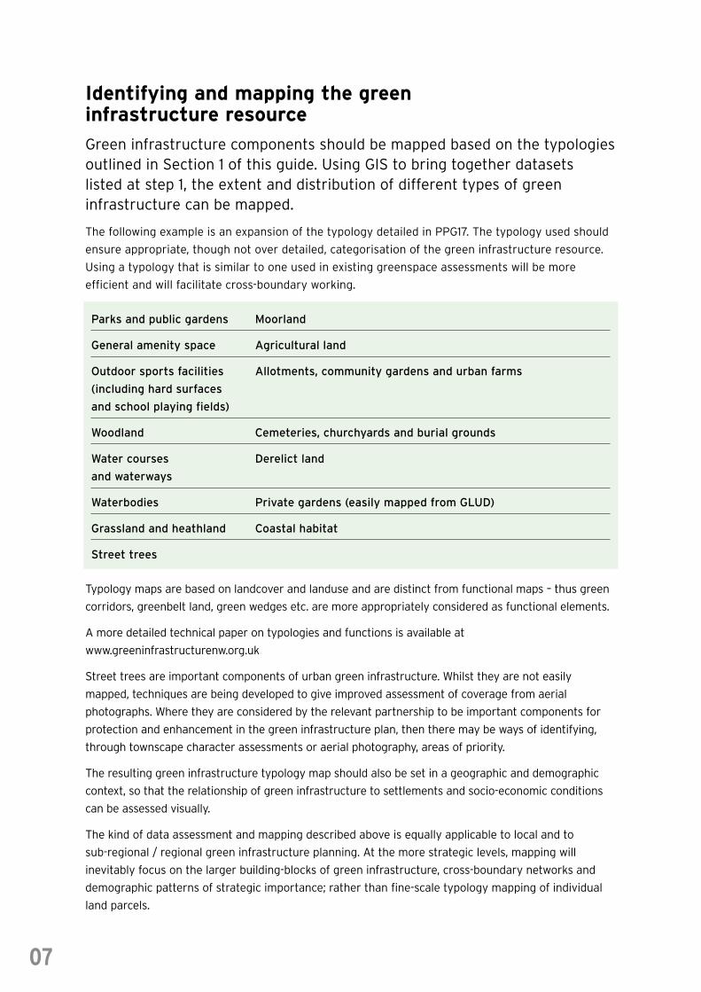
Green infrastructure components should be mapped based on the typologiesoutlined in Section 1 of this guide. Using GIS to bring together datasets listed at step 1, the extent and distribution of different types of greeninfrastructure can be mapped.
The following example is an expansion of the typology detailed in PPG17. The typology used should
ensure appropriate, though not over detailed, categorisation of the green infrastructure resource.
Using a typology that is similar to one used in existing greenspace assessments will be more
efficient and will facilitate cross-boundary working.
Parks and public gardens Moorland
General amenity space Agricultural land
Outdoor sports facilities Allotments, community gardens and urban farms
(including hard surfaces
and school playing fields)
Woodland Cemeteries, churchyards and burial grounds
Water courses Derelict land
and waterways
Waterbodies Private gardens (easily mapped from GLUD)
Grassland and heathland Coastal habitat
Street trees
Typology maps are based on landcover and landuse and are distinct from functional maps – thus green
corridors, greenbelt land, green wedges etc. are more appropriately considered as functional elements.
A more detailed technical paper on typologies and functions is available at
www.greeninfrastructurenw.org.uk
Street trees are important components of urban green infrastructure. Whilst they are not easily
mapped, techniques are being developed to give improved assessment of coverage from aerial
photographs. Where they are considered by the relevant partnership to be important components for
protection and enhancement in the green infrastructure plan, then there may be ways of identifying,
through townscape character assessments or aerial photography, areas of priority.
The resulting green infrastructure typology map should also be set in a geographic and demographic
context, so that the relationship of green infrastructure to settlements and socio-economic conditions
can be assessed visually.
The kind of data assessment and mapping described above is equally applicable to local and to
sub-regional / regional green infrastructure planning. At the more strategic levels, mapping will
inevitably focus on the larger building-blocks of green infrastructure, cross-boundary networks and
demographic patterns of strategic importance; rather than fine-scale typology mapping of individual
land parcels.
07
2.3 Step 3 – Functionality Assessment
A functionality assessment is required to locate gaps in physical orfunctional provision. A spatial representation of the policy framework andconsideration of the drivers of landscape change that influence greeninfrastructure needs to be undertaken in order to inform the resultingintervention plan.
Assessing quality and functionalityof green infrastructureGreen infrastructure planning focuses on conserving land of significant green infrastructure
function and enhancing the quantity, quality and connectivity of land which could serve such
functions.
In order to determine the functionality of green infrastructure components, it is necessary to
consider:
• the ways an area is used:
• how it performs;
• and the role it plays at both micro and macro scales.
The functions which green infrastructure performs are discussed in a number of studies (see
Section 5 – References), notably including Brandt et. al. (2000), Bartlett School of Planning (2004),
East Midlands Green Infrastructure Scoping Study (2005), Countryside In and Around Towns (2005)
and Barber (2005). Case Studies at Section 3 provide more details on these approaches. A range of
social, economic and environmental functions are cited. The following list of functions is a very
simplified précis of the in-depth analysis in these studies:
• Sport and active recreation
• Access to natural greenspace
• Mental and physical health
• Image and investment
• Land and property value
• Education and life-long learning
• Social inclusion
• Intrinsic value of a place to a community
• Flood management
• Air, water and soil quality
• Climate change adaptability
• Landscape character / sense of place
• Biodiversity
• Connectivity within a network
• Setting for tourism
• Availability for social enterprises
• Food, fishery and energy production
• Historic resource
• Setting for culture
08
The list is deliberately loosely defined. Some functions appear most relevant when green
infrastructure is viewed at “macro” scales (e.g. connectivity, productivity, climate change, flood).
Some functions only come into play when there is a specific association between a community and
a place. Functions can co-exist, leading to multifunctionality, and can therefore aid economic,
environmental and social objectives through the spatial integration of land uses and activities.
Where functions co-exist, interactions between functions will occur, some of which will be
synergistic e.g. the benefits to community safety and inclusion from sport and culture. Practitioners
may use the list, or the source material, to identify those functions most relevant to the strategic
priorities for their area of search.
Multi-functionality is generally desirable, as it encourages efficient use of land, delivers wider public
benefit and builds partnerships of user groups, leading to better stewardship. However, there will be
sensitive sites where the conservation of one particular green infrastructure function is of over-
arching importance.
An understanding of what functions areas of green infrastructure can provide is also informed by
people’s knowledge of an area and the importance they attach to its greenspaces. It is imperative to
have access to people who can provide this information at a local level. Workshops with
stakeholders identified in step 1 provide a useful way to capture detailed and wide-ranging
knowledge.
It is also useful to consider variables associated with a function
that can be used to determine a) if a function is, or is not,
present, and b) if it is present, whether it is working well. For
instance, the public health function of green infrastructure is
particularly needed where greenspace is near populations with
negative health indicators (e.g. high risk of heart disease).
Whether that green infrastructure is performing to the best of
its ability may be determined by a qualitative indicator which
shows whether healthy walking schemes operate in the area, or
assessments of the current use of an area by local people. This
begins to provide a basis for step 4 –? a more detailed needs
assessment.
Considering spatial implications of forces for changeTo fully understand how changes to green infrastructure should occur, strategic reasons as to why
these changes are necessary need to be established. By spatially representing both the forces for
change that are impacting on a landscape, and the
existing resource, the future for green infrastructure
can be planned. Forces for change may be planned
(e.g. regeneration of a post-industrial landscape);
or may be predictable (e.g. demographic shifts
associated with an expanding and ageing
population); or may be external and unpredictable
(e.g. the effects of climate change on biodiversity
and flood-management).
09
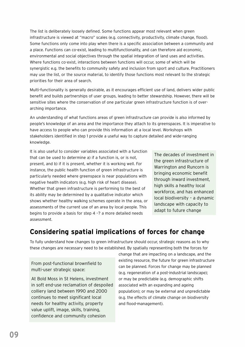
The decades of investment inthe green infrastructure ofWarrington and Runcorn isbringing economic benefitthrough inward investment,high skills a healthy localworkforce, and has enhancedlocal biodiversity – a dynamiclandscape with capacity toadapt to future change
From post-functional brownfield tomulti-user strategic space:
At Bold Moss in St Helens, investmentin soft end-use reclamation of despoiledcolliery land between 1990 and 2000continues to meet significant localneeds for healthy activity, propertyvalue uplift, image, skills, training,confidence and community cohesion
Analysis of strategy and policy information, carried out at step 1, can help spatial representation of
forces for change. Forces for change may mean that green infrastructure functions must be
protected or enhanced. This needs to be considered in the intervention plan. The case study
examples from St Helens and the East Midlands provide methodologies for this type of spatial
analysis.
Mapping of potential functionsPotential functions of the green infrastructure resource are a combination of policy and strategic
forces for change, and planned physical changes which are likely to occur in the future. Mapping
these proposed or potential changes to green infrastructure is necessary to feed into the
intervention plan. This information allows existing aspirations and plans for the area to be
acknowledged and to ensure recommendations made in the intervention plan take account of these,
and consider whether further enhancements to the green infrastructure resource could be achieved
through proposed projects.
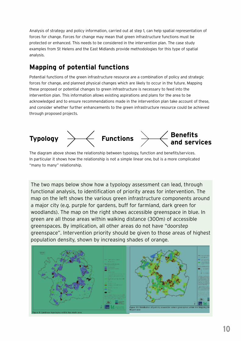
The diagram above shows the relationship between typology, function and benefits/services.
In particular it shows how the relationship is not a simple linear one, but is a more complicated
“many to many” relationship.
The two maps below show how a typology assessment can lead, throughfunctional analysis, to identification of priority areas for intervention. Themap on the left shows the various green infrastructure components arounda major city (e.g. purple for gardens, buff for farmland, dark green forwoodlands). The map on the right shows accessible greenspace in blue. Ingreen are all those areas within walking distance (300m) of accessiblegreenspaces. By implication, all other areas do not have “doorstepgreenspace”. Intervention priority should be given to those areas of highestpopulation density, shown by increasing shades of orange.
10
Typology Functions Benefitsand services
2.4 Step 4 – Needs Assessment
The needs assessment considers how the green infrastructure of an areacurrently meets the needs of the particular communities it serves; how wellit sustains environmental quality; how its performance will be affected byfuture changes; and how all these can be improved through the interventionplan.
Identifying whether green infrastructureis appropriate to local needsStep 2 will have indicated whether green infrastructure is operating effectively for all the
functions considered to be important in the area. Step 3 allows more detailed consideration of
socio-economic requirements, needs and deficits specific to the area of the green infrastructure
plan. Locally-distinctive approaches are needed – the green infrastructure needs in a rural district
will differ from those of the urban fringes within a City Region.
By comparing the mapped green infrastructure resource with land use and socio-economic
information, and with local knowledge, it is possible to identify areas which have specific needs;
or where deficits can be identified.
At a neighbourhood level, for instance, there
may be nowhere for workers to take a break
from employment, relax in the open air, eat their
lunch or meet friends. In terms of economics,
a local area may have a poor image due to the
presence of ‘grot spots’ or low house prices
because of a lack of green infrastructure.
Alternatively, the available types of greenspace
may not provide for particular needs.
For instance, a local nature reserve will not offer a suitable place for children to play. Deficits may
be due to barriers to accessing green infrastructure – such as major transport routes impeding easy
access from a needy community to a local sports park, or areas of remote countryside inaccessible
to those using public transport.
There are some national standards relating to green infrastructure provision, the best known being
the Accessible Natural Greenspace Targets (ANGST). GIS techniques can rapidly locate
neighbourhoods which have shortfalls of accessible greenspace – in response, resources can be
allocated to creating new greenspaces, or improving the quality of existing greenspaces to improve
their capacity.
Where there are no national standards relating to green infrastructure functions such as economic
contribution or health, the green infrastructure in an area can still be benchmarked against local
and regional averages to identify areas of apparent need.
11
Increasing the functions of existing spaces:
Furey Woods in Northwich was anabandoned patch of woodland servinglittle purpose – until residents clubbedtogether to turn it into a communityeducational resource – somewhere forchildren to play and experience wildlife.
Needs assessment will benefit from engagement with a diversity of stakeholders. In St Helens,
the Local Strategic Partnership focused strongly on issues of crime and health which were seen as
barriers to enjoyment of greenspace; and conversely, as social issues which could be tackled
through improved greenspace management.
Although a priority at local level, needs assessment is also part of sub-regional or cross-boundary
green infrastructure planning – the needs may be more strategic in nature; such as climate change
adaptation, flood risk planning, regeneration and biodiversity opportunity.
Determine how strategic priorities can be representedby datasets and linkages made to existing greeninfrastructureMatching strategic priorities and specific needs in an area to the existing green infrastructure
resource allows the identification of how green infrastructure currently operates and what changes
are needed in order for it to become a more fully functioning system. Specific datasets can assist in
spatially representing strategic priorities. The Office for National Statistics offers a vast array of
information at a range of spatial scales which can be used to relate, for instance, multiple deprivation
to the green infrastructure resource that was identified in step 2. Examples of this approach to
spatial articulation of strategic priorities are provided through the case studies in part 3.
In considering need, appropriate responses should be considered from the outset. These three
courses of action form the basis for the intervention plan:
• Creation of new green infrastructure
• Conservation of existing green infrastructure from functional changes
• Enhancement through new and/or alternative uses and management of land to provide
appropriately functioning green infrastructure
The table shows, for two different land types, how their respective green infrastructure functions
might be identified and enhanced in response to local needs. The first example is of urban fringe
equestrian enterprise land which is presently performing few green infrastructure functions and
delivering relatively little public benefit. Because of its strategic location, its potential contribution to
economic growth (through image uplift) and environmental sustainability (through access and
habitat improvements), it could perform several new functions; while retaining its ability to sustain
existing uses. The need here is for creation of green infrastructure.
The second example is an urban park with obvious importance to surrounding communities.
It already delivers significant public benefit so the key is to enhance and refresh those green
infrastructure functions which it already provides; while seeking opportunities to create new training
and enterprise opportunities, and to diversify and sustain habitats for future climate change.
12
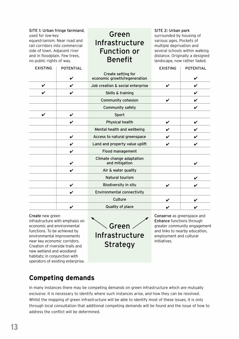
SITE 1: Urban fringe farmland,used for low-keyequestrianism. Near road andrail corridors into commercialside of town. Adjacent riverand in floodplain. Few trees,no public rights of way.
GreenInfrastructure
Function orBenefit
GreenInfrastructure
Strategy
Create new greeninfrastructure with emphasis oneconomic and environmentalfunctions. To be achieved byenvironmental improvementsnear key economic corridors.Creation of riverside trails andnew wetland and woodlandhabitats; in conjunction withoperators of existing enterprise.
Conserve as greenspace andEnhance functions throughgreater community engagementand links to nearby education,employment and culturalinitiatives.
EXISTING4
4
4
4
4
4
POTENTIAL
4
4
4
4
4
4
4
4
4
4
4
4
4
4
4
4
4
4
Create setting foreconomic growth/regeneration
Job creation & social enterprise
Skills & training
Community cohesion
Community safety
Sport
Physical health
Mental health and wellbeing
Access to natural greenspace
Land and property value uplift
Flood management
Climate change adaptationand mitigation
Air & water quality
Natural tourism
Biodiversity in situ
Environmental connectivity
Culture
Quality of place
EXISTING
4
4
4
4
4
4
4
4
4
4
4
4
4
POTENTIAL
4
4
4
4
4
4
4
4
4
4
4
4
4
4
4
4
SITE 2: Urban parksurrounded by housing ofvarious ages. Pockets ofmultiple deprivation andseveral schools within walkingdistance. Originally a designedlandscape, now rather faded.
13
Competing demandsIn many instances there may be competing demands on green infrastructure which are mutually
exclusive. It is necessary to identify where such instances arise, and how they can be resolved.
Whilst the mapping of green infrastructure will be able to identify most of these issues, it is only
through local consultation that additional competing demands will be found and the issue of how to
address the conflict will be determined.
2.5 Step 5 – Intervention Plan
Mapping green infrastructure is not an end in itself. An Intervention Planneeds to be established. Some interventions are within the reach of theplanning system; others require changes in targeting of resources used forland management; others require consideration of green infrastructure asthe sustainable development component of investment in regeneration andeconomic development.
In the North West, actions may include:
1 creating new green infrastructure associated with new built development;
2 refreshing existing (or creating new) green infrastructure in areas of regeneration priority;
3 improving management of rural and urban open lands so they fulfil more green infrastructure
functions, and collectively contribute to a sustainable landscape.
Locally-endorsed intervention and delivery plans should identify type, size and locations of assets
required, and the contribution levels expected to assist in their delivery, including the improved
resourcing and management of existing and future green infrastructure assets.
Where are changes needed?Steps 1 to 4 outline where changes in green infrastructure resources are required, based on
strategic priorities, functional assessment and specific local needs. These requirements will be
unique to the area the Intervention Plan is being prepared for. The implications of adjacent
Intervention Plans must be considered to ensure cross-boundary compliance and integration of
priorities and action on the ground. Regional and sub-regional green infrastructure plans must
inform the priorities of local plans and “smooth” cross-boundary working. Equally, local plans need
to feed into sub-regional strategies.
What changes are needed,and by what means arethey sought?When creating and changing green infrastructure,
long-term maintenance and management must
not be forgotten. One of the outcomes of green
infrastructure planning should be that land
management takes on a more holistic and
rationalised quality. If carried out correctly,
effective management will meet a number of
policy goals using less resources than if each
goal was pursued separately. Acknowledging the
multi-functional nature of green infrastructure can
help secure funding from different sectors over
the long term.
14
From “single-functional” farmland tomultifunctional landscapes for living;
At the new housing development ofStamford Brook, river corridor restoration,creation of new community woodland,neighbourhood greenspaces sustainabledrainage systems and new cycle routesmeet the needs for improved floodmanagement, property value, biodiversityand healthy recreation. Long-termmanagement is secured through abespoke estate management body to beset up by developers Redrow Homes andTaylor Woodrow with the National Trustmaintaining a long-term board position.
Delivery through the Local Development PlanThe planning system is essential to the integrated delivery of green infrastructure across the region.
Strategically significant existing and potential networks and sites of green infrastructure importance
should be safeguarded, where appropriate, within Local Development Frameworks and Supplementary
Planning Documents. There should be a co-ordinated approach across the plan area (and into
neighbouring authorities) to ensure green assets are interlinked.
An example of a core policy from Northamptonshire is provided below. Another alternative, which may
be more suitable to some Local Development Frameworks, is to embed green infrastructure principles
into policies on other issues. The content of the policy prescription should see the planning, design,
management and maintenance of green infrastructure as an integrated, multidisciplinary and long
term requirement. This includes a requirement to protect and conserve existing green infrastructure
where it is of high quality and already providing appropriate functions, improve or add functionality
where required, and create new assets where green infrastructure is lacking.
North Northamptonshire Core Strategy – Policy 5: The Green Framework
A net gain in green infrastructure will be sought through the protection and enhancement of
assets and the creation of new multifunctional areas of green space that promote recreation and
tourism, public access, green education, biodiversity, water management, the protection and
enhancement of the local landscape and mitigation of climate change, along with green economic
uses and sustainable land management.
Sub-Regional Green Infrastructure corridors will connect locations of natural heritage, green
space, biodiversity or other environmental interest. They will be safeguarded through:
a) Not permitting development that compromises their integrity and therefore that of the overall
green infrastructure framework
b) Using developer contributions to facilitate improvements to their quality and robustness
c) Investing in enhancement and restoration where the opportunities exist, and the creation of
new resources where necessary
Development will contribute towards the establishment, enhancement or ongoing management of
a series of local corridors linking with the sub-regional corridors. Priorities for investment will be
those areas where net gains in the range of functions can be improved, particularly those that
improve access to the urban core and rural service centres and remedy local deficiencies in open
space provision and quality.
Endowments or other sources of ring-fenced funds should be sought from development and set
aside for future revenue requirements. This could include taking a strategic approach to the use of
Section 106 agreements to deliver green infrastructure via the planning system. This approach has
been investigated in the South East Growth Areas where a framework for securing the delivery of
strategic and local infrastructure through land value capture, based around the planning system,
has been set out in a paper produced for the Milton Keynes-South Midlands Inter-Regional Board in
October 2004. This advocates a joined-up approach to the delivery of infrastructure through
developer contributions, encouraging local planning authorities to consider how a range of
developments can contribute to the delivery of necessary infrastructure.
The way in which planning gain is used is actively under review which may have implications for the
North West’s ability to deliver strategic green infrastructure. However, developer contributions
alone will not deliver sufficient funds to provide a significant gain in green infrastructure in the
North West, other than in localised areas associated with development.
15
Delivery through alignment with regenerationand infrastructure schemesOf course, the development control aspects of the planning system only have a limited sphere of
influence and find it particularly difficult to secure investment in green infrastructure ahead of
development. There are many areas of the North West where there will be significant physical
regeneration and investment in economic development. These include major developments in the
three City Regions, Housing Market Renewal Areas, Strategic Sites, Urban Regeneration Companies,
Coalfield Portfolio Sites, Rural Key Service Centres, key tourism areas and many other local
initiatives. Government agencies will also be investing in physical infrastructure (road / rail /
waterways).
Regional Economic Strategy highlights the importance
of investment in greenspace and environmental quality
for such areas. Sub-regional and local intervention plans
should prioritise such areas and seek structural funding
for investment in green infrastructure where it can be
shown to deliver transformational benefits to such
initiatives.
At a local level, the inclusion of green infrastructure in
LSP delivery plans and Local Area Agreements will help
to secure mainstream and bespoke funding streams
(managed at local level) focus on green infrastructure
creation and management. This is a rapidly emerging
area of activity and practitioners should take advantage
of the opportunities afforded – many LAAs do seek
“Cleaner, Safer, Greener” outcomes, for example.
Delivery through Land ManagementThis need to manage green infrastructure to meet social, economic and environmental agendas may
also open up opportunities to attract match funding from a range of organisations, including
realising opportunities to increase the contribution of rural areas to green infrastructure through
improved management and access. This may be partly assisted by, for instance, the new
Environmental Stewardship Scheme which promotes sustainable land management. Land managers
will therefore be a key group of stakeholders with whom to engage in terms of long-term
management of green infrastructure including consideration of possible new structures for managing
land in a way which supports green infrastructure. Contributions from corporate social responsibility
and carbon-sequestration initiatives provide resources for green infrastructure implementation.
In order to take advantage of the changing political, planning and corporate frameworks, we may
also want to look at examples of longer term governance models for green infrastructure
development and management, including:
• An informal partnership of supportive
organisations
• A semi-autonomous, formalised partnership
of supportive organisations
• A group of existing Local Delivery Partnerships
• An independent Trust or Company
• A new Park Authority or similar
organisation
• A Regional Park Development Company
16
“For the Central Lancashire CityRegion Development Plan, thedriver for green infrastructure iseconomic; and the emphasis will beon pursuing only those works whichadd value to the overall objectivesof the CLCRDP. This will involve thedevelopment of comprehensive yetstrategic green infrastructure as atransformational action. This willinclude the further development ofregional parks in Lancashire.”
Lancashire Economic Partnership –consultation response, August 2006
What is a good green infrastructure plan?The previous sections have shown that green infrastructure planning should take account of local
need. However, there are certain features that should be common to any good green infrastructure
plan. Any plan should:
• Effectively communicate the concept of green infrastructure
• Holistically address the three pillars of sustainability
• Build effective partnerships and leadership at strategic and local levels
• Recognise and advocate the need for improved management and funding of resources for
green infrastructure
• Ensure commonality with other Local Authorities, thus ensuring an integrated approach across
boundaries, while allowing local distinctiveness
• Provide a comprehensive map or plan of the existing GI resource – and a vision of how it might
be improved and sustained
• Set and determine strategic priorities taking account of regional and sub-regional strategies,
public benefit assessment and stakeholder opinion
• Give a public statement of a will to improve green infrastructure
• Set targets and outline mechanisms to attain such targets
• Provide long-term targets
• Monitor and revise the plan based on best available information
• Be a ‘Living’ document, updated and enhanced as resources and information becomes available
so that it remains relevant and a source of information to all those involved in planning and
delivering green infrastructure
17
3.0 Case Studies
The following case studies illustrate aspects of green infrastructureplanning, and represent differing spatial scales, strategic priorities and localcircumstances.
Public Benefit Recording SystemThe Public Benefit Recording System (PBRS) was developed as a system to anticipate and measure
the delivery of socio-economic and environmental benefits through green space provision and
derelict land remediation. It can be considered on two levels: as a technical, GIS based aid to
strategic planning and investment, and as a philosophy for assisting social, economic and
environmental sectors to work together in land management and regeneration.
East Midlands Green Infrastructure Scoping StudyThe Scoping Study was commissioned to investigate the underlying causes of the under-investment
in green infrastructure in the East Midlands region, outside of the Milton Keynes Growth Area. It
demonstrates a detailed approach to typology mapping and functional assessment of greenspaces.
It also identifies drivers of landscape change and recommends actions for organisations in the region
to collectively improve delivery of green infrastructure.
St Helens Countryside In and Around Towns approachThe approach integrates the Countryside Agency and Groundwork UK, Countryside In and Around
Towns Vision (CA207) into the planning of the urban fringe. The Metropolitan Borough of St Helens
was used as the test area with the project forming part of the wider national Countryside Agency
programme of Countryside In and Around Towns.
Green Futures CLERE Model for Multifunctional GreenspaceThe CLERE model identifies five broad functions of greenspace; community, landscape, ecosystem,
recreation, and economy. It provides detailed examination of the rationale behind each function and
management strategies to enhance each function. This model is taken from the recently published
book Green Future (published by GreenSpace Publications).
The North East Green Infrastructure Planning GuideThe North East Green Infrastructure Planning Guide was undertaken by a number of partners in the
North East of England. It is an aid to the production of geographically based green infrastructure
plans, and provides practitioners with a more informed and systematic way of considering the
competing priorities of green infrastructure within the spatial planning process.
18
Countryside In and Around Towns:The Green Infrastructure of Yorkshire & the HumberSimilar to the St Helens case study, the Countryside Agency and Groundwork’s Countryside In and
Around Towns (CIAT) vision provided the basis for this regional study to map green infrastructure
assets and explore those policies and mechanisms by which green infrastructure is recorded,
protected and enhanced.
Case Study 1: Public Benefit Recording SystemWhat is PBRS?
The Public Benefit Recording System (PBRS) was developed as a system to anticipate and measure
the delivery of socio-economic and environmental benefits through green space provision and
derelict land remediation. It provides a combined social, economic and environmental baseline of
needs and opportunities, helping to aid decision makers on where green space provision actually
meets green infrastructure principles: conserving, creating and improving open spaces that meet
local needs or fill gaps in the green infrastructure network.
PBRS can be considered on two levels: as a technical, GIS-based aid to strategic planning and
investment, and as a philosophy for assisting social, economic and environmental sectors to work
together in establishing a new understanding and approaches to green infrastructure delivery.
How does PBRS work?
An area’s public benefit potential is assessed using an objective GIS map-based system. This is
applied by decision makers – assisting in the prioritisation of green space investment to maximise
sustainable project outputs.
Data from across the social, economic and environmental spectrum is gathered in layers:
Layer 1 is comprised of the existing Government data on socio-economic deprivation contained in
the Indices of Deprivation (ID). In general terms, the PBRS approach seeks to determine the broadest
profile of deprivation and, as such, tends to use all of the seven ID domains together. However, for a
more refined or targeted approach, it is possible and appropriate to select and de-select particular
domains, and to benchmark ID for the region, or to rural / urban settlements.
Layer 2 (Thematic Focus) contains additional data which can be laid on the socio-economic baseline
to perform a variety of analytical functions. Again, this layer of data can include a number of distinct
datasets depending on the scope of the PBRS, tailoring it to provide a particular thematic focus.
Layer 3 (Constraints & Opportunities) contains information on opportunities and constraints,
considering the practicalities of project delivery to take account of physical, legal and policy contexts
in relation to the illustration of public benefit potential created by Layer One and Layer Two.
Layer 4 holds information which helps to define the target areas, themes or outcomes on specific
sites or spatial areas, to further the appreciation of scope for project delivery or solely for recording
site attributes and useful information.
PBRS can be applied on almost any geographical scale, from site based to regional (provided that
appropriate data is available), allowing results to be finely tuned or broad-based in nature.
19
The Value of Local Knowledge
PBRS demonstrates an evidence base from which planners and decision makers can make reasoned
judgements on maximising public benefit through green infrastructure planning and green space
provision. Some level of vision and ‘entrepreneurship’ is needed to make those decisions and carry
out those actions which really deliver the results, and the intelligence and insights generated by
PBRS need to be considered alongside local knowledge and local priorities to truly guarantee that
green infrastructure investment is maximised to meet local needs and respond to opportunities.
Examples of PBRS application
PBRS has been applied in several projects to identify gaps / opportunities in provision and to target
activity namely Newlands, Environmental Equity, Affordable Housing in Cumbria.
Developed by:
TEP and Forestry Commission NW, in partnership with NWDA, GONW, Defra RDS, Community Forests
Northwest, and other regional and sub regional stakeholders.
Case Study 2:East Midlands Green Infrastructure Scoping Study
The Integrated Regional Strategy for the East Midlands identifies theenhancement of Environmental Infrastructure as a key challenge for theregion. Environmental Infrastructure is the overall framework that providesfor the sustainable use of environmental resources (minerals and water),waste management, sustainable travel and construction, and a high qualitybuilt and natural environment. Green Infrastructure is a central componentof Environmental Infrastructure and has been identified as the first priorityfor improved action across the region.
Foundations for a GI Network
The success of the study in achieving its objectives is a direct result of the constructive and
enthusiastic input of organisations working at all levels across the East Midlands through
Stakeholder Workshops and dialogue. However, this study marks the beginning of a long but vital
process. Success will rely on the commitment of stakeholders to act upon the recommendations
arising from the study, which are commended to the region by the East Midlands Regional Assembly
Environment Group.
Strategic Fit
The role of green infrastructure in contributing to sustainable development and prosperity, in
conjunction with wider environmental provision and considerations, is reinforced by its strong fit
within key national and regional policies. At a regional level, green infrastructure sits firmly as a
spatial and thematic concept, reinforcing the objectives and priorities of the Integrated Regional
Strategy, the Regional Environment Strategy, the emerging Regional Spatial Strategy and the
Regional Economic Strategy.
20
Identifying Existing Green Infrastructure Typology and Function
Mapping commenced with the identification of green infrastructure ‘typologies’ (categories of
greenspace) through aerial photography interpretation. A wide range of spatial data was then
analysed to determine the role of each greenspace in relation to a range of economic, social and
environmental themes. This analysis identifies which spaces have multiple functions or important
single functions, and also where physical intervention might unlock further functions that are not
presently apparent.
Delivery Impediments
• The misalignment of key policy drivers and funding mechanisms, most notably in relation to the
restrictive nature of single pot funding criteria which focus heavily on direct economic outputs
• A lack of consistent understanding of the principles and benefits of green infrastructure
across the region
• Land and environmental constraints relating to the resource intensive nature of negotiations with
landowners, the need for long-term stewardship that may extend beyond the capacity or interest
of landowners, which is exacerbated by a paucity of revenue funding mechanisms for asset
management
• The prevailing silo mentality of many public sector organisations resulting from the separation of
functions and geographic remits between departments
Key Recommendations
Several measures can be implemented by partners in the region to overcome many of the issues
relating to green infrastructure mapping and delivery of enhanced greenspaces. They include:
• Stakeholders need to coalesce into a GI Network, to help drive the agenda on
Green Infrastructure forward
• Bring together the Green Infrastructure Network to develop a public benefit assessment
framework that is aligned to the multi-functional role of Green Infrastructure in order to
determine strategic priorities
• The policies that support green infrastructure at a national and regional level should be reflected
in the Regional Economic Strategy and flow through to sub-regional and local policies and plans
• The GI Network should work to ensure sub-regional plans reflect regional and national
level plan focus
• A central data resource should be created within the region that is owned by the GI Network i.e. a
regional digital data exchange portal that allows organisations to download spatial datasets for
synthesis in a GIS platform
• Mechanisms for providing long-term stewardship of green infrastructure and for accruing
endowments to provide for long-term maintenance should be explored within the region and with
central Government, with particular emphasis on the feasibility of a Regional Environment Fund.
21
Delivering Public Benefits through green infrastructure
A further study was undertaken to identify whether the Public Benefit Recording System (PBRS)
could be applied to identify where the greatest public benefit could be derived from investments in
Green Infrastructure in the East Midlands region.
Geographical Information Systems (GIS) were used to map where green infrastructure could
contribute to the 17 social, economic and environmental objectives of the Region’s Integrated
Regional Strategy (IRS), resulting in the production of ‘public benefit’ maps.
The maps highlight particular areas within the region where social, economic, environmental and
combined needs and opportunities are greatest, with the greatest depth of public benefit generally
derived where greatest need and opportunity coincide and where multiple objectives may be
delivered in parallel. The implications of these results were assessed in terms of priorities for the
delivery of green infrastructure and the implications for the region’s spatial strategy, population
growth, quality of life and sustainable development, providing a firm evidence base for strategic
investment in green infrastructure to deliver regional objectives in an integrated manner.
Champions and Delivery Partnership
The database of stakeholders developed through this project will form the basis of a Green
Infrastructure Network (GIN) for the coordinated delivery of green infrastructure across the East
Midlands region.
The East Midlands Green Infrastructure Scoping Study was prepared by TEP, IBIS Environment &
Design Consultants, and Alison Millward Associates. For further information please contact TEP on
01925 844004.
Case Study 3:St Helens - Planning for the Countryside Inand Around Towns
The countryside in and around towns in St Helens is significant in size andopportunity. Over half of the Borough is designated as greenbelt withadditional green wedges and greenways running through the central urbancore, linking town and country.
At the outset of the project, a steering group comprising the Countryside Agency, Groundwork Trust,
The Mersey Forest, the University of Liverpool and St Helens Council was put in place to guide
development. The Mersey Forest provided the lead and a dedicated project officer.
Initially the study area was categorised and mapped in order to build a picture of its existing
functions. This drew together 96 datasets (including local authority information, habitat coverage,
designations, and historic characterisation) to form individual function maps of the area. This was
matched by analysis of local and regional strategies such as Transport Plans, Greenspace Strategies
and Agricultural Landholdings Plans to identify policies which would help to contribute to an
improved green infrastructure in and around St Helens. Policy statements were spatially articulated
by linkage to individual and multiple functions through an evidence database.
22
Green infrastructure functions were grouped into four themes; health, education, recreation, and
regeneration. These are particularly relevant to the priorities of the Community Plan and Local
Strategic Partnership, and reflect wider sub-regional and local focus topics.
These themes were also used to understand the different types of needs and negative trends found
in local communities which could be improved through increased accessibility to, and use of, high
quality countryside in and around towns. 2001 census data, Index of Multiple Deprivation, Attitudes
Questionnaire, an Open Space Audit and local expertise were used to identify needs in each thematic
area. Mapping the co-existence of functions within each theme allowed multi-functional resources to
be understood. Opportunity areas within the urban fringe were identified from this analysis allowing
raised awareness of the significant resource already available to local people.
A landscape character assessment considered urban, urban fringe and rural landscapes, and these
character areas were compared with the functions. This showed which character areas were strongly
associated with particular themes and how recommendations for retaining and improving landscape
character and quality could be incorporated into emerging policy for the countryside in and around
St Helens. The evidence database was used in the emerging Local Development Framework process.
Recommendations were developed at three levels recognising the important positive contribution
the countryside in and around St Helens can make to a range of social, economic and environmental
agendas.
• Firstly, the evidence database should be maintained and updated as it provides an excellent
source of information with many uses for both St Helens Council and other interested
organisations
• Secondly, through the project the understanding of the urban fringe had been improved, and
awareness and recognition of the importance of different functions and their inter-relationships
meant that the countryside in and around St Helens should be integrated into the Local
Development Framework
• Finally, recommendations specific to the issues found in St Helens within each of the themes of
health, education, recreation and regeneration were developed. These ranged from making
the evidence database available for schools’ use to providing an integrated approach for use in
considering the development of a Forest Park
The demonstration project has been a successful starting point for raising awareness and
understanding of the sometimes overlooked countryside in and around towns, and the many
functions and uses these areas can provide for local communities. In St Helens this approach is being
taken forward through further engagement with the Local Strategic Partnership. Through the work
of The Mersey Forest Team it is also anticipated that this approach will inform the planning and
delivery of high quality, multifunctional green infrastructure across the Mersey belt.
For further information please contact Paul Nolan at The Mersey Forest on 01925 816217 or email
23
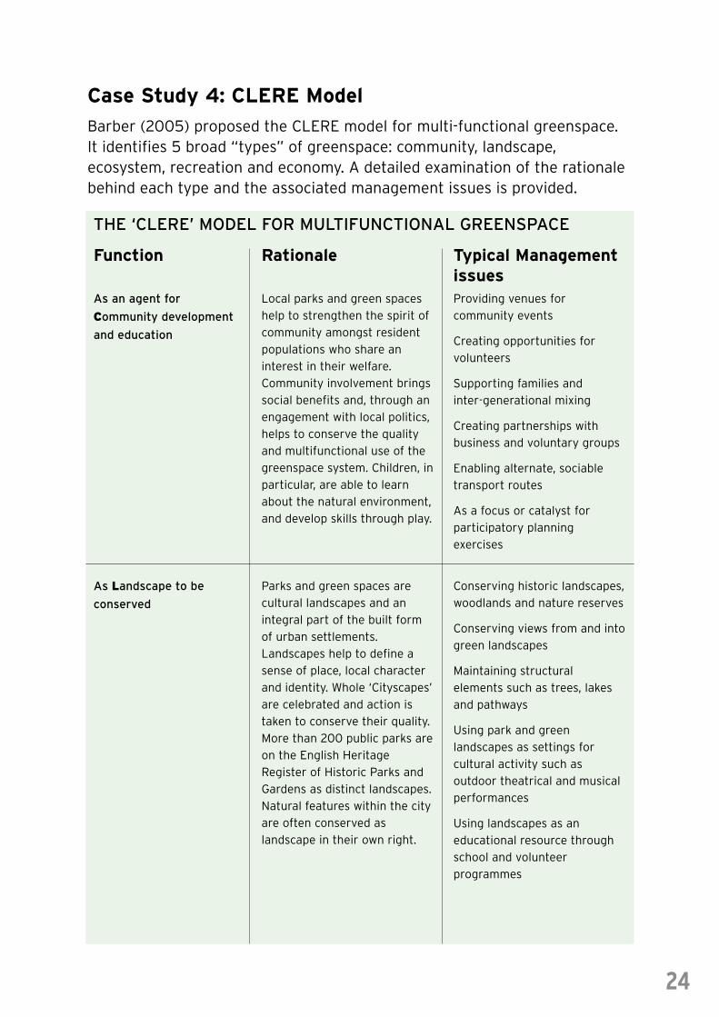
Case Study 4: CLERE Model
Barber (2005) proposed the CLERE model for multi-functional greenspace.It identifies 5 broad “types” of greenspace: community, landscape,ecosystem, recreation and economy. A detailed examination of the rationalebehind each type and the associated management issues is provided.
24
As an agent for
Community development
and education
Local parks and green spaces
help to strengthen the spirit of
community amongst resident
populations who share an
interest in their welfare.
Community involvement brings
social benefits and, through an
engagement with local politics,
helps to conserve the quality
and multifunctional use of the
greenspace system. Children, in
particular, are able to learn
about the natural environment,
and develop skills through play.
Providing venues for
community events
Creating opportunities for
volunteers
Supporting families and
inter-generational mixing
Creating partnerships with
business and voluntary groups
Enabling alternate, sociable
transport routes
As a focus or catalyst for
participatory planning
exercises
As Landscape to be
conserved
Parks and green spaces are
cultural landscapes and an
integral part of the built form
of urban settlements.
Landscapes help to define a
sense of place, local character
and identity. Whole ‘Cityscapes’
are celebrated and action is
taken to conserve their quality.
More than 200 public parks are
on the English Heritage
Register of Historic Parks and
Gardens as distinct landscapes.
Natural features within the city
are often conserved as
landscape in their own right.
Conserving historic landscapes,
woodlands and nature reserves
Conserving views from and into
green landscapes
Maintaining structural
elements such as trees, lakes
and pathways
Using park and green
landscapes as settings for
cultural activity such as
outdoor theatrical and musical
performances
Using landscapes as an
educational resource through
school and volunteer
programmes
Function
THE ‘CLERE’ MODEL FOR MULTIFUNCTIONAL GREENSPACE
Rationale Typical Managementissues
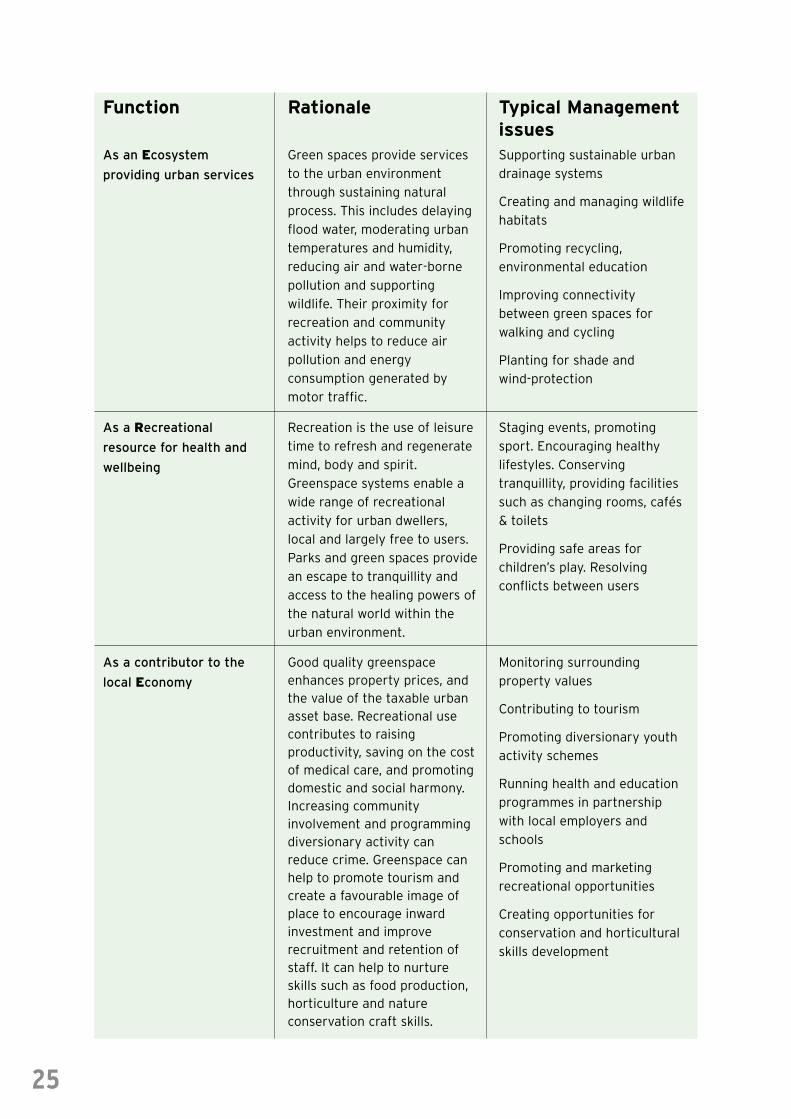
25
As an Ecosystem
providing urban services
Green spaces provide services
to the urban environment
through sustaining natural
process. This includes delaying
flood water, moderating urban
temperatures and humidity,
reducing air and water-borne
pollution and supporting
wildlife. Their proximity for
recreation and community
activity helps to reduce air
pollution and energy
consumption generated by
motor traffic.
Supporting sustainable urban
drainage systems
Creating and managing wildlife
habitats
Promoting recycling,
environmental education
Improving connectivity
between green spaces for
walking and cycling
Planting for shade and
wind-protection
As a Recreational
resource for health and
wellbeing
Recreation is the use of leisure
time to refresh and regenerate
mind, body and spirit.
Greenspace systems enable a
wide range of recreational
activity for urban dwellers,
local and largely free to users.
Parks and green spaces provide
an escape to tranquillity and
access to the healing powers of
the natural world within the
urban environment.
Staging events, promoting
sport. Encouraging healthy
lifestyles. Conserving
tranquillity, providing facilities
such as changing rooms, cafés
& toilets
Providing safe areas for
children’s play. Resolving
conflicts between users
As a contributor to the
local Economy
Good quality greenspaceenhances property prices, andthe value of the taxable urbanasset base. Recreational usecontributes to raisingproductivity, saving on the costof medical care, and promotingdomestic and social harmony.Increasing communityinvolvement and programmingdiversionary activity canreduce crime. Greenspace canhelp to promote tourism andcreate a favourable image ofplace to encourage inwardinvestment and improverecruitment and retention ofstaff. It can help to nurtureskills such as food production,horticulture and natureconservation craft skills.
Monitoring surrounding
property values
Contributing to tourism
Promoting diversionary youth
activity schemes
Running health and education
programmes in partnership
with local employers and
schools
Promoting and marketing
recreational opportunities
Creating opportunities for
conservation and horticultural
skills development
Function Rationale Typical Managementissues
Case Study 5:The North East Green Infrastructure Planning Guide
Partners in the North East of England have produced a Green InfrastructurePlanning Guide, facilitating the production of geographically based greeninfrastructure plans, and providing practitioners with a more informed andsystematic way of considering the competing priorities of greeninfrastructure within the spatial planning process.
The Guide presents a 10 step guide to the use of Geographic Information Systems, resulting in a
baseline green infrastructure typology map.
This can then be used as a tool to support planners in making informed judgements about green
infrastructure within their area of responsibility, identifying 6 key questions which must be
considered once the baseline map is established (some of which will require extra GIS datasets to be
combined with the baseline green infrastructure typology):
• What green infrastructure elements must be protected?
• What elements should be changed in character or enhanced?
• Where is there a need to create new elements and what type should they be?
• Where should the development of grey infrastructure be integrated with green infrastructure?
• Which elements should be linked together?
• Which elements are possibly tradable to achieve net environmental gains in both an infrastructure
and qualitative sense?
The questions are based on a matrix that considers quality and infrastructure to provide a clear but
flexible framework for the assessment of individual green spaces and links and their
interrelationships. The ‘quality’ elements distinguishes between low, acceptable and high quality
greenspaces, while the ‘infrastructure’ axis focuses on connectivity and integrity of the networks
which combine to form infrastructure – with a high quality green infrastructure recognised as high
quality green spaces and routes that are linked together to form coherent, multi-functional networks.
This approach provides users – including planners, strategists and policymakers, landscape architects
and regeneration specialists – with a flexible technique that will assist in establishing those existing
green infrastructure resources that should be conserved, those which should be enhanced or
changed, and where new green infrastructure should be created.
Developers:
Northumbria University, North East Community Forests, University of Newcastle upon Tyne,
The Countryside Agency (Landscape, Access, Recreation), English Nature, Forestry Commission,
Groundwork. Available at www.necf.org.uk/inc/getDoc.php?id=46
26
Case Study 6:The Green Infrastructure of Yorkshire & the HumberThe Countryside Agency and Groundwork’s Countryside In and AroundTowns (CIAT) Vision provided the basis for this regional study to map greeninfrastructure assets and explore those policies and mechanisms by whichgreen infrastructure is recorded, protected and enhanced.
Approach taken
Using GIS software, comprehensive mapping of green assets was undertaken, allowing the region to
be assessed as to where any gaps in green space provision lay and identifying options on how green
infrastructure potential could be better realised. An analysis of relevant strategies and plans from
the local to the national level determined not just where green infrastructure was represented and
supported, but also how it was ‘joined up’ in policy and its promotion in the region’s emerging spatial
planning framework.
Key Findings
The study found that there is great potential for the development and application of a green
infrastructure approach in Yorkshire and the Humber.
GIS technology was considered to be an effective tool for mapping both the extent of and potential
for green infrastructure, and a useful method for future policy development, especially in relation to
Countryside In and Around Towns. However, the indication was that there was scope for much more
joined-up thinking about green assets, how to link them into networks and how to better realise their
potential contribution to the region.
Recommendations
The development of green infrastructure approaches in Yorkshire and the Humber was considered
both an achievable and realistic progression from the current situation, but that certain
recommendations would have to be acted upon:
• An agreed definition of green infrastructure and the green infrastructure approach (as suggested
in the study’s report) should be adopted across the region
• The commitment of key regional stakeholders to the green infrastructure approach should be
explicitly reflected in regional strategies, most urgently the Regional Spatial Strategy
• GIS and related data should be gathered and held as a central regional resource to help map and
support regional green infrastructure development
• Natural England in Yorkshire and the Humber should continue in the development and promotion
of both the CIAT agenda and the green infrastructure approach, particularly in promoting urban-
rural connectivity aspects
• Regional ecological structure and recreational routes networks should be mapped, using an
inclusive approach that would result in a ‘people’s map’ of green infrastructure, encourage
participation in local spatial planning and help build community cohesion
• Key mainstream funding bodies should seek to provide substantial and reliable financial support
for NGOs and communities to undertake locally important green infrastructure projects
27
• A Green Infrastructure Pathfinder Project (GIPP) should be supported to test out alternative ways
to realise the green infrastructure approach on the ground, and to explore the potential for local
communities and enterprises to become actively involved and take ownership of local green
spaces
• A regional Green Infrastructure Network should be established, developing a strong and diverse
partnership that can pursue the green infrastructure approach, secure ‘buy-in’ of and ownership
from key stakeholders, and to act as a signpost to green infrastructure resources and advice
www.yhub.org.uk/resources/Statutory%20Bodies/CIA-report-July06.pdf
28
4.0 Green Infrastructure in Relation to EmergingNorth West Policy and Strategy
National, regional and sub-regional documents set the ethos of greeninfrastructure planning and stimulate strategic actions. Four key regionaldocuments with a strong influence on green infrastructure are outlinedbelow. These are followed by a table listing a number of types of documentwhich were identified during consultation on this Guide which can helpgreen infrastructure practitioners identify the priorities for their area ofsearch and scale of influence.
Regional Spatial StrategyDraft Regional Spatial Strategy policy EM3 on green infrastructure states that plans, strategies,
proposals and schemes should:
• Identify, promote and deliver multi-purpose networks of greenspace, particularly where there is
currently limited access to natural greenspace or where connectivity between these places
is poor
And
• Integrate green infrastructure provision within existing and new development, particularly within
major development and regeneration schemes
This policy is also cross referenced to draft policy EM4 on Regional Parks and RT7 which promotes
a regional framework for walking and cycling. There are also numerous references within the
Regional Spatial Strategy and its policies to high quality design, improving local environmental
quality, cleaning and greening neighbourhoods and developing sustainable communities, including
within its sub-regional development frameworks.
When adopted, the statutory nature of the Regional Spatial Strategy will mean policy EM3 will
eventually form part of the development plan.
Regional Economic StrategyTwo transformational activities within the Regional Economic Strategy relate directly to green
infrastructure. They are:
• Transformational activity 113 – Develop the economic benefit of the region’s natural environment
through better alignment of environmental activities and economic gain
• Transformational activity 119 – Invest in quality public realm/greenspace/environmental quality
focused on the cities of Liverpool, Manchester and Preston; Tourism “Attack Brand” and
“Signature Project” locations and key arrival points; Housing Market Renewal and Urban
Regeneration Companies; Key Rural Service Centres
In addition, delivering more, higher quality and improved functionality of green infrastructure relates
to a number of other activities within the Regional Economic Strategy. These include:
• Improving regional image
• Adapting to climate change
• Reducing worklessness
• Reducing long term health related work absences
Regional Rural Delivery FrameworkThe Regional Rural Delivery Framework Priority 6 concerns:
• Enhancing the quality of, and promotion of, our rural environmental inheritance
Outcome 6.3 calls for:
• Maximising the contribution the rural environment can make to the economic and social wellbeing
of the region, where the natural and historic environment is an integral component and
recognised for the socio-economic benefits it provides
Key Objective 6.3.4 calls for:
• The development and implementation of a strategic approach to planning and delivering more
and improved green infrastructure
Improved provision and functionality of green infrastructure relates to many of the objectives within
RRDF Priority 6 as well as those within Priority 2 (promoting a prosperous sustainable farming and
food sector that contributes to the environment and social wellbeing of the region).
Regional Forestry FrameworkThe development of more, higher quality and improved multi-functional green infrastructure relates
to many of the priorities set out in the Regional Forestry Framework, including those under:
Action Area 2 – Regional Image.
Action Area 3 – Biodiversity and Landscape.
Action Area 4 – Health, Wellbeing and Quality of Life.
Action Area 5 – Climate Change and Energy.
29
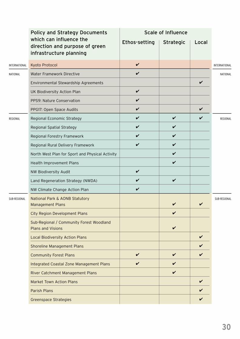
Kyoto Protocol
Water Framework Directive
Environmental Stewardship Agreements
UK Biodiversity Action Plan
PPS9: Nature Conservation
PPG17: Open Space Audits
Regional Economic Strategy
Regional Spatial Strategy
Regional Forestry Framework
Regional Rural Delivery Framework
North West Plan for Sport and Physical Activity
Health Improvement Plans
NW Biodiversity Audit
Land Regeneration Strategy (NWDA)
NW Climate Change Action Plan
National Park & AONB Statutory
Management Plans
City Region Development Plans
Sub-Regional / Community Forest Woodland
Plans and Visions
Local Biodiversity Action Plans
Shoreline Management Plans
Community Forest Plans
Integrated Coastal Zone Management Plans
River Catchment Management Plans
Market Town Action Plans
Parish Plans
Greenspace Strategies
INTERNATIONAL
NATIONAL
REGIONAL
SUB-REGIONAL
INTERNATIONAL
NATIONAL
REGIONAL
SUB-REGIONAL
Policy and Strategy Documentswhich can influence thedirection and purpose of greeninfrastructure planning
Scale of Influence
Ethos-setting Strategic Local
30
4
4
4
4
4
4 4
4 4 4
4 4
4 4
4 4
4
4
4
4 4
4
4 4
4
4
4
4
4 4 4
4 4
4
4
4
4
5.0 Useful Sources of Information and References
The following section aims to provide some background information,evidence and relevant contacts for those practitioners who may not yet havebeen involved in green infrastructure planning or management but who willbe integral to the successful development of green infrastructure. It alsosets out some key literature references that provide a starting point forthinking how green infrastructure may help you derive benefits for yourown work.
NW Green Infrastructure UnitThe NW Green Infrastructure Unit exists to develop and promote green infrastructure concepts and
planning in the NW region. The GIU supports the Green Infrastructure Forum and Think Tank as well
as assisting in the delivery of regional and sub-regional projects and plans.
A regional website is maintained by the NW Green Infrastructure Unit. The website provides a
central resource for information on green infrastructure in the NW including projects ongoing (this
guide is available to download). It will continue to be developed into a regional resource and can be
accessed at www.greeninfrastructurenw.org.uk
NW Green Infrastructure Think Tank The NW Green Infrastructure Think Tank is a group established by the Green Infrastructure Unit
that exists to provide cross-sectoral technical advice and feedback on developing regional green
infrastructure approaches and activities. The group is drawn from a variety of practitioners,
academics, policy makers and agencies relevant to green infrastructure.
NW Green Infrastructure Forum The Green Infrastructure Forum is an open Forum for discussion of GI concepts, development of
technical information and showing of ideas.
References• A better quality of life – a strategy for sustainable development in the UK (1999), DETR
• Barber A (2005) Green Future, GreenSpace Publications
• Barker G (1997) A Framework for the Future: green networks with multiple uses in and around
towns and cities. Research Report No. 253, English Nature, Peterborough
• Bartlett School of Planning (2004). Vision for a sustainable multi-functional
rural-urban fringe
• Biodiversity by Design: a Guide for Sustainable Communities (2004), Town and Country
Planning Association (http://www.tcpa.org.uk/biodiversitybydesign/index.htm)
31
• Brandt J, Tress B and Tress G, (eds) (2000) Multifunctional landscapes: interdisciplinary
approaches to landscape research and management, Centre for Landscape Research,
Roskilde University, Denmark
• CABE Space (2004) Green Space Strategies: A Good Practice Guide
• Countryside Agency and Groundwork UK (2005). Vision for the Countryside in and Around
Towns, Countryside Agency publications
• East Midlands Green Infrastructure Scoping Study (2005), East Midlands Regional Assembly
and partnership
• Enriching Our Region: an Environmental Manifesto for the West Midlands (2005), West
Midlands Regional Sustainability Forum (http://www.cprewm.org.uk/EnvManifesto.pdf)
• Green Infrastructure for the Liverpool and Manchester City-regions (2005), Community
Forests Northwest & The Countryside Agency
• Green Infrastructure Strategy (2006), Cambridgeshire Horizons.
(http://www.cambridgeshirehorizons.co.uk/Document_links_det.asp?id=3433)
• Green Infrastructure for Sustainable Communities (2005), Environment Agency, Countryside
Agency & Partners (http://www.culturesoutheast.org.uk/media/uploads/18/4%20Pager.pdf)
• Green Spaces, Better Places (2002), The Urban Greenspaces Taskforce, DTLR
• Greenhalgh L and Worpole K (1995), Park Life: Urban Parks and Social Renewal,
Comedia and Demos
• Harrison C, Burgess J, Millward A and Dawe G (1995) Accessible Natural Greenspace in Towns
and Cities. Research Report No. 153, English Nature, Peterborough
• Nature for People: the importance of green spaces to East Midlands communities (2004),
Research Report No. 567, English Nature, Peterborough
• Nature Conservation and Local Community Strategies (2003), English Nature Leaflet
32
www.naturaleconomynorthwest.co.uk
www.greeninfrastructurenw.org.uk
Both these websites are continually updated with the latest available information and reports on
Green Infrastructure Planning.
Any comments on either website can be forwarded to The Green Infrastructure Unit.
SOURCES OF ADDITIONAL INFORMATION
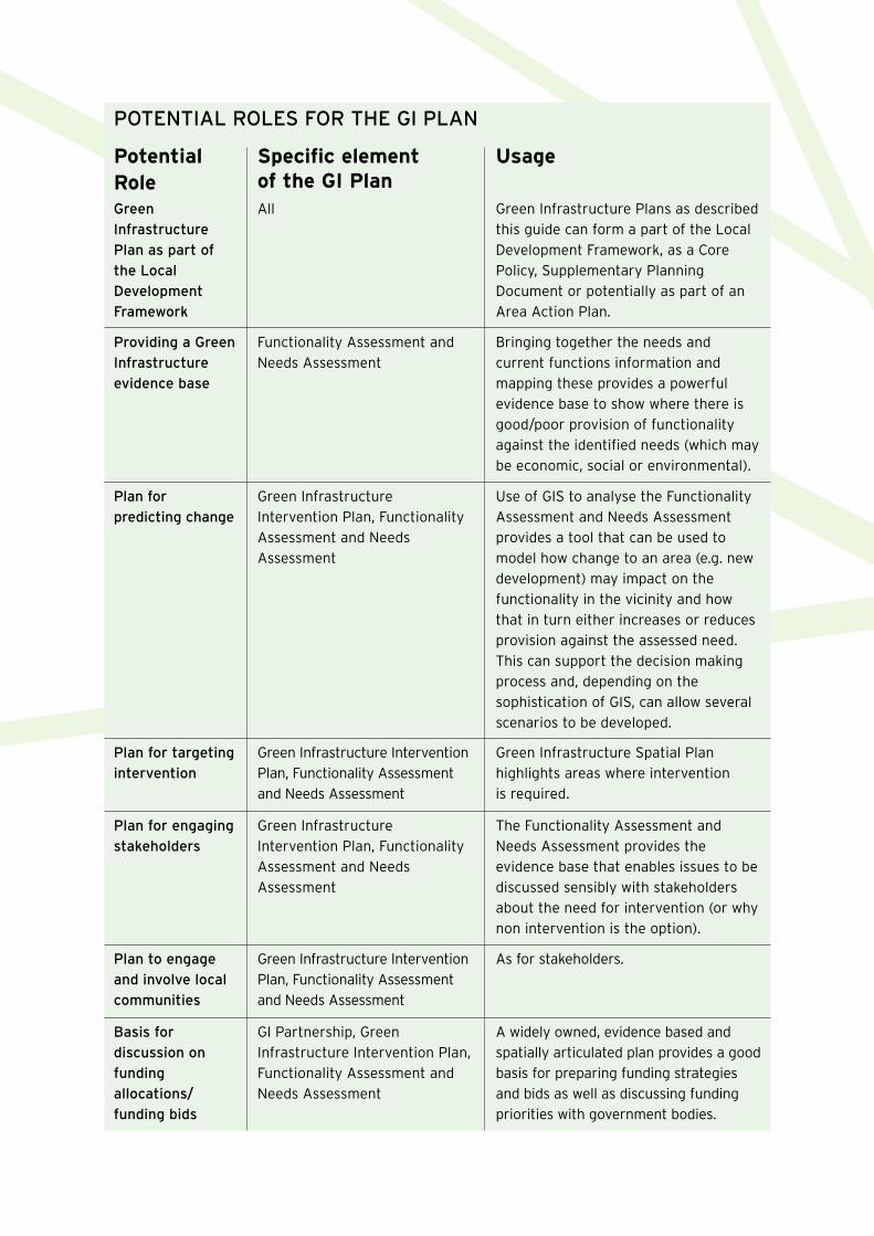
Green
Infrastructure
Plan as part of
the Local
Development
Framework
All Green Infrastructure Plans as described
this guide can form a part of the Local
Development Framework, as a Core
Policy, Supplementary Planning
Document or potentially as part of an
Area Action Plan.
Providing a Green
Infrastructure
evidence base
Functionality Assessment and
Needs Assessment
Bringing together the needs and
current functions information and
mapping these provides a powerful
evidence base to show where there is
good/poor provision of functionality
against the identified needs (which may
be economic, social or environmental).
PotentialRole
POTENTIAL ROLES FOR THE GI PLAN
Specific elementof the GI Plan
Usage
Plan for targeting
intervention
Green Infrastructure Intervention
Plan, Functionality Assessment
and Needs Assessment
Green Infrastructure Spatial Plan
highlights areas where intervention
is required.
Plan for engaging
stakeholders
Green Infrastructure
Intervention Plan, Functionality
Assessment and Needs
Assessment
The Functionality Assessment and
Needs Assessment provides the
evidence base that enables issues to be
discussed sensibly with stakeholders
about the need for intervention (or why
non intervention is the option).
Plan to engage
and involve local
communities
Green Infrastructure Intervention
Plan, Functionality Assessment
and Needs Assessment
As for stakeholders.
Basis for
discussion on
funding
allocations/
funding bids
GI Partnership, Green
Infrastructure Intervention Plan,
Functionality Assessment and
Needs Assessment
A widely owned, evidence based and
spatially articulated plan provides a good
basis for preparing funding strategies
and bids as well as discussing funding
priorities with government bodies.
Plan for
predicting change
Green Infrastructure
Intervention Plan, Functionality
Assessment and Needs
Assessment
Use of GIS to analyse the Functionality
Assessment and Needs Assessment
provides a tool that can be used to
model how change to an area (e.g. new
development) may impact on the
functionality in the vicinity and how
that in turn either increases or reduces
provision against the assessed need.
This can support the decision making
process and, depending on the
sophistication of GIS, can allow several
scenarios to be developed.
The North WestGreen InfrastructureThink Tank Partners:
CABE Space
Cass Associates
Cure
Environment Agency
Forestry Commission
Government Office North West
Green Space North West
Groundwork
Natural Economy North West
Natural England
North West Regional Assembly
Red Rose Forest
TEP
The Mersey Forest
University of Salford
North WestGreen
InfrastructureGuide
P R E P A R E D B Y T H E N O R T H W E S T G R E E N I N F R A S T R U C T U R E T H I N K T A N K
©Natural England/Rob Petley-Jones
©C
ount
rysi
de A
genc
y