Embed Size (px)
Citation preview
December 2017
Native vegetation gain
scoring manual
Version 2

Cover image: Hattah-Kulkyne National Park, Victoria, DELWP (Penny Croucamp)
© The State of Victoria Department of Environment, Land, Water and Planning 2017
This work is licensed under a Creative Commons Attribution 4.0 International licence. You are free to re-use the work under that licence, on the condition that you credit the State of Victoria as author. The licence does not apply to any images, photographs or branding, including the Victorian Coat of Arms, the Victorian Government logo and the Department of Environment, Land, Water and Planning (DELWP) logo. To view a copy of this licence, visit http://creativecommons.org/licenses/by/4.0/
ISBN 978-1-76047-866-7 (pdf)
Disclaimer
This publication may be of assistance to you but the State of Victoria and its employees do not guarantee that the publication is without flaw of any kind or is wholly appropriate for your particular purposes and therefore disclaims all liability for any error, loss or other consequence which may arise from you relying on any information in this publication.
Accessibility
If you would like to receive this publication in an alternative format, please telephone the
DELWP Customer Service Centre on 136186, email [email protected]
or via the National Relay Service on 133 677 www.relayservice.com.au. This document is
also available on the internet at www.delwp.vic.gov.au.
Page 1 of 65
1 Introduction ............................................................................................................................................ 2
2 Gain ......................................................................................................................................................... 3
2.1 What is gain? ....................................................................................................................... 3
2.2 Types of vegetation that can generate gain ..................................................................... 3
2.3 Types of gain ....................................................................................................................... 4
2.4 Gain scoring assessment ................................................................................................... 5
2.6 How is the gain score used? .............................................................................................. 7
3 Offset site eligibility .............................................................................................................................. 8
3.1 Security ................................................................................................................................ 8
3.2 Current land use and future land use................................................................................ 8
3.3 Existing offsets or existing agreements ........................................................................... 8
3.4 Threats to native vegetation condition ............................................................................. 8
3.5 Managing bushfire risk of offset sites............................................................................... 9
3.6 Freehold land transferred to the Crown ............................................................................ 9
3.7 Existing Crown land ............................................................................................................ 9
3.8 Minimum standards for protected vegetation ................................................................ 10
3.9 Offset management ........................................................................................................... 11
4 Minimum commitments to generate gain ......................................................................................... 13
4.1 Prior management gain .................................................................................................... 13
4.2 Security gain ...................................................................................................................... 13
4.3 Maintenance gain and improvement gain ....................................................................... 16
5 Description of management commitments ...................................................................................... 20
5.1 Large trees ......................................................................................................................... 20
5.2 Tree canopy cover ............................................................................................................. 20
5.3 Understorey ....................................................................................................................... 21
5.4 Lack of weeds .................................................................................................................... 25
5.5 Recruitment ........................................................................................................................ 25
5.6 Organic litter ...................................................................................................................... 25
5.7 Logs .................................................................................................................................... 26
5.8 Additional commitment for scattered trees .................................................................... 27
5.9 Additional commitments for revegetation ...................................................................... 27
5.10 Additional commitments for Crown land ........................................................................ 27
Appendices .................................................................................................................................................... 29
Glossary ......................................................................................................................................................... 63
Contents
Page 2 of 65
This manual describes the approach for calculating
the predicted improvement in native vegetation
quality and quantity due to active management and
increased security of the native vegetation. This
improvement is referred to as ‘gain’.
The approach in this manual is closely linked to the
vegetation quality assessment method outlined in
Native vegetation: sustaining a living landscape.
Vegetation Quality Assessment Manual – Guidelines
for applying the habitat hectares scoring method,
Version 1.3 (VQA manual). Users of this approach
are expected to have a working knowledge of the
vegetation quality assessment method in order to
adequately calculate the gains due to active
management and increased security.
The method described enables the user to calculate
gains over a 10 year time frame. This approach
assumes that the site will receive the required
management and security for this period in order for
the gains to be realised. In general, this will require
the use of an appropriate management agreement
that sets out the land management commitments
and actions for the ten year period to achieve the
predicted gains. Where required, it is possible to use
the approach outlined in this manual to
proportionally calculate gains for other periods of
management.
This document specifies:
• the considerations used in the prediction of the
amount of gain at a site
• the information used to calculate the gain score
• when gain is available
• how much gain is generated from management
and security commitments.
Where vegetation is to be protected as an offset to
compensate for biodiversity loss from the removal of
native vegetation, Guidelines for the removal,
destruction or lopping of native vegetation (the
Guidelines) describe the eligibility requirements for
the offset site. Section 3 details these requirements
for offset site eligibility.
The eligibility requirements for sites that are
unrelated to offsets are generally specified in the
specific incentive or grants program. However, it is
likely the same eligibility criteria would be
considered and applied for any program.
1 Introduction
Page 3 of 65
2.1 What is gain?
Gain results from commitments to protect, maintain
and improve native vegetation condition. Gain is
available at a site where the commitments are
higher than the landowner’s current legal
management responsibilities (duty of care). This is
known as ‘additionality’. Activities that landowners
undertake to meet their current duty of care will not
generate gain.
A landowner’s legal management responsibilities
include:
• legislative requirements, particularly the
Catchment and Land Protection Act 1994
• requirements of existing agreements or contracts
that apply to the site
• planning scheme requirements to retain native
vegetation.
On Crown land, the community expects Crown land
managers to undertake a certain level of
management to protect biodiversity values as
funding is made available to undertake this
management. Therefore, a stronger case for
‘additionality’ is required to generate gain on Crown
land.
2.2 Types of vegetation that can generate gain
Native vegetation is defined in planning schemes as
‘plants that are indigenous to Victoria, including
trees, shrubs, herbs and grasses’1. Native
vegetation is further classified as a patch of native
vegetation or a scattered tree.
Vegetation that can generate gain can be any or a
combination of the following, provided it meets the
eligibility requirements described in section 3:
• a patch of native vegetation
• scattered trees
• revegetation.
For the purposes of this manual, reference to ‘vegetation’ includes a patch of native vegetation, scattered trees or revegetation.
1 Victoria Planning Provision – Definitions – Clause 72.
Patch of native vegetation
A patch of native vegetation is:
• an area of native vegetation where at least 25% of
the total perennial understorey plant cover2 is
native, or
• any area with three or more native canopy trees3
where the drip line4 of each tree touches the drip
line of at least one other tree, forming a continuous
canopy.
Scattered tree
A scattered tree is:
• a native canopy tree that does not form part of a
patch.
Revegetation
Revegetation is the establishment of native
vegetation to a minimum prescribed standard, in
areas that do not qualify as a patch or a scattered
tree.
Where vegetation is to be protected as an
offset to compensate for biodiversity loss
from the removal of native vegetation,
Guidelines for the removal, destruction or
lopping of native vegetation (Guidelines)
describe the eligibility requirements for the
offset site, the type of vegetation, and the
minimum security standards.
2 Plant cover is the proportion of the ground that is shaded by vegetation
foliage when lit from directly above. Areas that include non-vascular
vegetation (such as mosses and lichens) but otherwise support no
native vascular vegetation are not considered to be a patch for the
purposes of the Guidelines. However, when non-vascular vegetation is
present with vascular vegetation, it does contribute to cover when
determining the percentage of perennial understorey plant cover.
3 A native canopy tree is a mature tree (i.e. it is able to flower) that is
greater than 3 metres in height and is normally found in the upper
layer of the relevant vegetation type.
4 The drip line is the outermost boundary of a tree canopy (leaves and/or
branches) where the water drips on to the ground.
2 Gain
Page 4 of 65
2.3 Types of gain
Different types of gain can be generated by
landowners or land managers, these are described
below.
On freehold land any security or
management commitments must be agreed
to by the landowner. On Crown land the
agreement must be made by the Crown
land manager. For the purposes of this
manual, “landowner” includes both
landowner and Crown land manager where
information relates generally to both
freehold and Crown land.
Prior management gain
Prior management gain acknowledges management
undertaken by landowners on a freehold site since
State-wide planning permit controls for native
vegetation removal were introduced in 1989.
Security gain
Security gain results from increasing the protection
of native vegetation on a specific site. Landowners
can generate security gain by recording a security
agreement on the land title (for example under
Section 69 of the Conservation Forests and Lands
Act 1987 or a conservation covenant under Section
3A of the Victorian Conservation Trust Act 1972).
Landowners can also generate security gain by
transferring freehold land to a secure Crown land
reserve managed for conservation purposes.
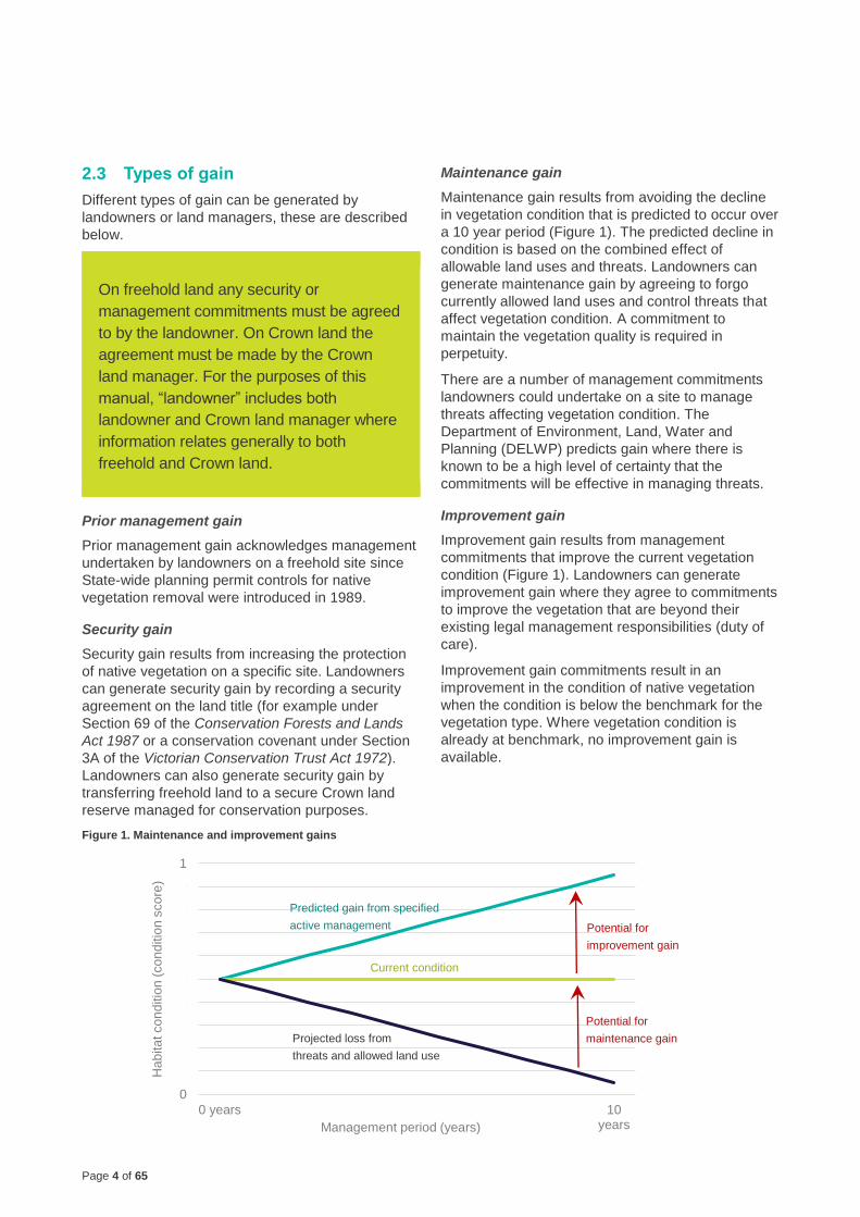
Maintenance gain
Maintenance gain results from avoiding the decline
in vegetation condition that is predicted to occur over
a 10 year period (Figure 1). The predicted decline in
condition is based on the combined effect of
allowable land uses and threats. Landowners can
generate maintenance gain by agreeing to forgo
currently allowed land uses and control threats that
affect vegetation condition. A commitment to
maintain the vegetation quality is required in
perpetuity.
There are a number of management commitments
landowners could undertake on a site to manage
threats affecting vegetation condition. The
Department of Environment, Land, Water and
Planning (DELWP) predicts gain where there is
known to be a high level of certainty that the
commitments will be effective in managing threats.
Improvement gain
Improvement gain results from management
commitments that improve the current vegetation
condition (Figure 1). Landowners can generate
improvement gain where they agree to commitments
to improve the vegetation that are beyond their
existing legal management responsibilities (duty of
care).
Improvement gain commitments result in an
improvement in the condition of native vegetation
when the condition is below the benchmark for the
vegetation type. Where vegetation condition is
already at benchmark, no improvement gain is
available.
Figure 1. Maintenance and improvement gains
0
0.1
0.2
0.3
0.4
0.5
0.6
0.7
0.8
0.9
1
0 years 10years
Hab
ita
t co
nd
itio
n (
co
nd
itio
n s
co
re)
Management period (years)
Predicted gain from specified
active management
Current condition
Potential for
improvement gain
Projected loss from
threats and allowed land use
Potential for
maintenance gain
Page 5 of 65
2.4 Gain scoring assessment
The process of calculating the gain that can be
generated at a site is called gain scoring. A gain
scoring assessment includes:
• a site assessment, including an assessment of a
site’s eligibility, threatening processes and weed
cover, and
• calculation of the gain score.
The gain calculator has been developed by DELWP to assist with determining the gain score in accordance with this manual. The calculator is available on the DELWP website.
2.4.1 Site assessment
A site assessment must be completed by an
accredited native vegetation assessor and includes:
• A habitat hectare assessment of any patches of
native vegetation to be protected, including the
‘habitat score’, extent (in hectares), Ecological
Vegetation Class (EVC) and bioregional
conservation status. The habitat hectare
assessment method is described in the Native
vegetation: sustaining a living landscape.
Vegetation Quality Assessment Manual –
Guidelines for applying the habitat hectares
scoring method, Version 1.3 (VQA manual) (or its
successor).
Note: For the purpose of assessing native
vegetation removal and offsetting in Victoria, the
advice within the VQA manual regarding habitat
zone delineation has been superseded. See
below.
• The location, number, circumference (in
centimetres measured at 1.3 metres above ground
level) and species of large trees within patches.
• The location, number, circumference (in
centimetres measured at 1.3 metres above ground
level) and species of scattered trees, and whether
each tree is small or large.
• An assessment of a site’s eligibility, including an
assessment of significant threats (see section 3).
Accredited native vegetation assessors are listed on
DELWP’s Vegetation Quality Assessment
Competency Register and have current accreditation
(less than two years old at the time the site
assessment is completed). A site assessment report
must be current, as detailed in the Assessor’s
handbook – applications to remove, destroy or lop
native vegetation (Assessor’s handbook).
Habitat zone delineation
For the purpose of assessing native vegetation for
removal or offsetting, Chapter 5: Site Inspection -
“Estimating the required number and size of habitat
zones” of the VQA manual has been superseded.
The revised advice is:
• A Vegetation Quality Assessment (VQA) must be
constrained to a single EVC.
• A habitat zone is a single continuous patch of
vegetation of the same EVC.
• Changes in habitat condition should generally not
influence how a habitat zone is defined.
In general, a habitat zone at an offset site should
only be split based on the presence of a different
EVC, not based on a change in the vegetation
condition. However, a habitat zone must be split:
• when it cannot be reasonably represented by a
single VQA because:
– the site condition score (out of 75) varies by at
least 15 points and
– the extent of the continuous patch of vegetation
is greater than 1 hectare; or
• to exclude areas of the habitat zone that do not
meet the offset eligibility criteria detailed in section
9.1.3 of the Guidelines. That is, a minimum ‘site
condition score’ of 30 out of 75 and any treeless
EVC must also have a minimum ‘lack of weeds
score’ of 7 out of 15.
Page 6 of 65
2.4.3 Calculation of the gain score
Calculating a gain score is described below:
1. Review the eligibility criteria in section 3 to
confirm the site is eligible to generate gain.
2. Undertake a site assessment, as described in
section 2.4.1.
3. Confirm the landowner agrees to the minimum
security and management commitments
required to generate gain (see section 3).
4. Calculate the prior management gain, security
gain, maintenance gain and improvement gain
using the components of the habitat score
(Appendix 2 and 3).
5. Calculate the gain score (Appendix 4). The
gain score is the sum of prior management
gain, security gain, maintenance gain and
improvement gain to achieve a score out of
100.
Gain score = prior management gain + security gain +
maintenance gain + improvement gain
2.4.4 Is a gain scoring assessment always
required?
A gain scoring assessment must be undertaken in
the following circumstances:
• all third party offset sites
• where first party offset sites are generating
species habitat units, or are located within wetland
vegetation types.
DELWP has systems and tools that calculate a
simplified gain score. These tools allow a person
who is not an accredited native vegetation
assessors to assess their own property. The tools
can be used instead of undertaking a gain scoring
assessment in the following circumstances:
• a first party offset site generating general habitat
units only, and that is not located within wetland
vegetation types
• a Crown land offset site generating general habitat
units only, that is not located within wetland
vegetation types and the habitat units will not be
traded.
The Guidelines further explain when a gain scoring
assessment is required for offset sites.
Page 7 of 65
2.6 How is the gain score used?
The gain score can be combined with other site
attributes, values or metrics to give an overall
predicted gain in a specific metric. For example,
when the gain score is combined with the area in
hectares of the site the gain at the site will be
represented in habitat hectares.
To calculate ‘habitat hectares of gain’ the gain score
is divided by 100 to obtain a score between 0 and 1.
This number is multiplied by the extent (hectares) of
native vegetation.
Habitat hectares of gain
= extent of native vegetation × gain score
100
2.6.1 Incentive programs
Gain scoring can be used to measure predicted
improvement in native vegetation from security and
management commitments on sites unrelated to
offsets. An example of this could be government
incentive programs where landowners are required
to demonstrate the gains that they can deliver. For
these purposes the measure of improvement in the
vegetation quality and quantity at a site is often
expressed as ‘habitat hectares of gain’ (see
Appendix 4B).
While the broad steps for calculating gain outlined in
Section 3 are likely to be relevant, they may be
differently applied. For example, incentive programs
will have their own set of eligibility criteria, may
choose a different measurement of landscape scale
importance that suits the program’s purpose or may
weigh components differently to suit a range of
objectives.
It should also be noted that incentive programs may
consider whether prior management gain and
security gain, and the related commitments, will be
applicable.
2.6.2 Offset sites
The Guidelines are incorporated into the Victoria
Planning Provisions and all planning schemes in
Victoria. The Guidelines set out the state policy and
process for the assessment of impacts from
removing native vegetation. A native vegetation
offset is required to compensate for the loss to
biodiversity from approved removal of native
vegetation. The offset must deliver a gain in
biodiversity value that is equivalent to the loss in
biodiversity value from the removal of native
vegetation.
For the purpose of the Guidelines, the biodiversity
value of an offset site incorporates landscape scale
information (landscape factor) to measure the
importance of one location relative to other locations
in Victoria. The Guidelines provide further
information about landscape information and offset
requirements.
The biodiversity value of an offset site is measured
in ‘habitat units of gain’. A ‘general habitat unit of
gain’ provides a measure of the improvement in the
overall biodiversity value of native vegetation at the
site. A ‘species habitat unit of gain’ provides a
measure of the improvement in biodiversity value of
native vegetation at the site for a particular rare or
threatened species.
To calculate general habitat units of gain available at
an offset site, the habitat hectares of gain is
multiplied by a landscape factor (described in the
Guidelines):
General habitat unit of gain = habitat hectares of gain
× general landscape factor
To calculate species habitat units of gain available at
an offset site, the habitat hectares of gain is
multiplied by a landscape factor (described in the
Guidelines):
Species habitat unit of gain = habitat hectares of gain
× species landscape factor
Page 8 of 65
Where vegetation is to be protected as an offset to
compensate for biodiversity loss from the removal of
native vegetation, the Guidelines describe the
eligibility requirements for the offset site. This
section details these requirements. A site that does
not meet eligibility requirements cannot be used as
an offset.
The eligibility requirements for sites that are
unrelated to offsets are generally specified in the
specific incentive or grants program. However, it
is likely the same eligibility criteria would be
considered and applied for any program.
Eligibility criteria include consideration of:
• current land use and future land use (where
known)
• existing offsets or other existing agreements
• Crown land
• threats to native vegetation condition
• security
• minimum management actions
• revegetation.
These criteria are described below.
For first party offsets the responsible authority will
check a site’s eligibility. For potential third party offset
sites (where a landowner wishes to sell credits to
another landowner who needs an offset), a site’s
eligibility will be checked by the native vegetation credit
register (NVCR). The NVCR may have additional
criteria for third party offset sites to those described
below, refer to published NVCR information for further
detail.
3.1 Security
Offset sites must provide permanent compensation
for the loss in biodiversity value from the removal of
native vegetation. This is achieved via the security
commitments described in section 4.2.
3.2 Current land use and future land use
Current and future land use(s) must be compatible
with managing the native vegetation for
conservation. Incompatible current and future land
use may include:
• fuel reduction activities requiring removal of logs or
trimming/clearing of understorey plants or trees
• horse-riding, cycling or motorised vehicle use of
established tracks
• infrastructure easements
• areas identified for other uses that are
incompatible with managing native vegetation for
conservation. This includes those with a public
acquisition overlay for creation of a road or with
approval to undertake activities that will damage
native vegetation (e.g. extractive industries works
approvals)
• other ongoing land uses that are likely to degrade
vegetation condition or restrict improvement in
vegetation condition.
3.3 Existing offsets or existing agreements
An area of native vegetation is eligible to be an
offset if the native vegetation to be protected is:
• not already being used to offset other clearance of
native vegetation or species habitat required under
Victorian or federal legislation
• not subject to a current agreement or initiative to
generate carbon credits
• not subject to a current agreement under a
biodiversity or native vegetation related incentive
or grant program to undertake actions which are
equivalent to the commitments specified in Section
4.
An area of land is eligible if it was formerly subject to
an agreement and the agreement period has
expired.
3.4 Threats to native vegetation condition
Significant threats to the condition of native
vegetation impact on a landowner’s ability to
complete management commitments. An area of
native vegetation is not eligible to be an offset if the
landowner cannot control and manage significant
threats to the condition of the native vegetation and
ensure that over time the condition of the native
vegetation does not decline.
Any threat that can’t be controlled and prevents a
site from being appropriately managed will result in
an area of vegetation being ineligible to be used as
an offset. The assessor should consider whether site
management will be significantly affected by threats
to the native vegetation condition and whether the
management commitments agreed to by the
landowner would control the threat.
3 Offset site eligibility
Page 9 of 65
The following is a list of common issues or threats
that generally cannot be controlled:
• high levels of continued nutrient run off
• secondary salinity with a high likelihood of the
effect increasing
• continuing significant erosion which is
uncontrollable without affecting native vegetation
• significant invasion from introduced animals such
as rabbits, deer, goats and pigs
• extensive die-back or other plant diseases
• planned disturbance regimes incompatible with
native vegetation objectives such as fuel reduction
burning or flooding
• lack of, or inappropriate flooding regime
• highly invasive weeds that are difficult to control at
a site level.
3.5 Managing bushfire risk of offset sites
Managing an offset site for conservation objectives
may be in conflict with managing native vegetation
to reduce the risk to life and property from bushfire.
To eliminate this conflict all offset sites must meet
the following eligibility requirements in relation to
managing bushfire risk. An offset cannot be
established within:
• 150 metres of a dwelling5 or any area (building
envelope) to be used as a dwelling in the future if
the dwelling or area is within a Bushfire
Management Overlay (BMO)
• 50 metres of a dwelling or any area (building
envelope) that will or may be used as a dwelling in
the future, when the dwelling or area is not within a
BMO.
The distance can be reduced if the landowner or
manager of the offset site has written approval from
the Country Fire Authority, or relevant fire authority
as defined by the planning schemes, that this
distance can be safely reduced.
3.6 Freehold land transferred to the Crown
In addition to the eligibility requirements described
above, freehold land transferred to the Crown must
5 Dwelling includes any building used for accommodation.
meet the following eligibility requirements to be an
offset:
• the land meets the assessment criteria for
proposed regional conservation land acquisitions
• the minister responsible for administering the
applicable Act has agreed that the land can be
accepted into the Crown land estate
• the land is reserved in the parks and reserve
system under either the National Parks Act 1975
or Crown land (Reserves) Act 1978.
3.7 Existing Crown land
Crown land must meet the following eligibility
requirements to be an offset:
• the site meets all other eligibility requirements
described in this section
• a Crown land offset agreement is signed between
the Crown land manager and the DELWP
Secretary
• the offset site is reserved6 land, and can be
managed for conservation objectives
• the offset is only used to either:
– offset clearing on Crown land, OR
– to provide species offsets that are not available
on freehold land
• the site is highly unlikely to be used for another
purpose
• the site is clearly identifiable to land managers
• the surrounding land use is compatible with an
offset site in the long-term.
The process for establishing offsets on Crown land
must be transparent and demonstrate that gains are
real and that management actions are additional to
what is required by legislation.
3.7.1 Transparency - Native Vegetation Offset
Register
Crown land offset site managers are held to the
same standard of accountability as private land
offset site managers. Crown land offsets must be
visible to all current and future Crown land
managers and the public. All first and third party
6 This means land of the Crown that has been reserved or set aside for a
purpose under an Act.
Page 10 of 65
Crown land offsets must be registered on the Native
Vegetation Offset Register.
3.7.2 Additionality - Available gain
To ensure the objective of ‘no net loss’ is achieved,
actions at the offset site must be additional to base-
line management actions. On Crown land, the
community expects Crown land managers to
undertake a certain level of management to protect
biodiversity values as funding is made available to
undertake this management.
Demonstrable additionality constitutes actions that
are above the expected role of a public land
manager. For example basic weed management
would be considered a base-line responsibility of a
public land manager. Actions that are specifically
targeted towards improving habitat requirements for
a threatened species for which an offset is being
established could be considered additional.
3.8 Minimum standards for protected vegetation
The minimum standards described below may be
adapted for specific objectives determined under an
incentive program.
3.8.1 Patches of native vegetation
A patch of native vegetation assessed by an
accredited native vegetation assessor must meet the
following eligibility requirements to be an offset:
• have a minimum ‘site condition score’7 of 30 out of
75
• any treeless8 EVCs must also have a minimum
‘lack of weeds score’9 of 7 out of 15.
7 This is the site condition score determined in accordance with the VQA
Manual.
8 Treeless – refers to all vegetation types without a tree overstorey
(although may include taller shrublands and scrubs) and structurally
dominated by either woody or non-woody life forms. May also include
vegetation types with occasional emergent trees. And as defined in the
VQA Manual.
9 This is the lack of weeds score determined in accordance with the VQA
Manual.
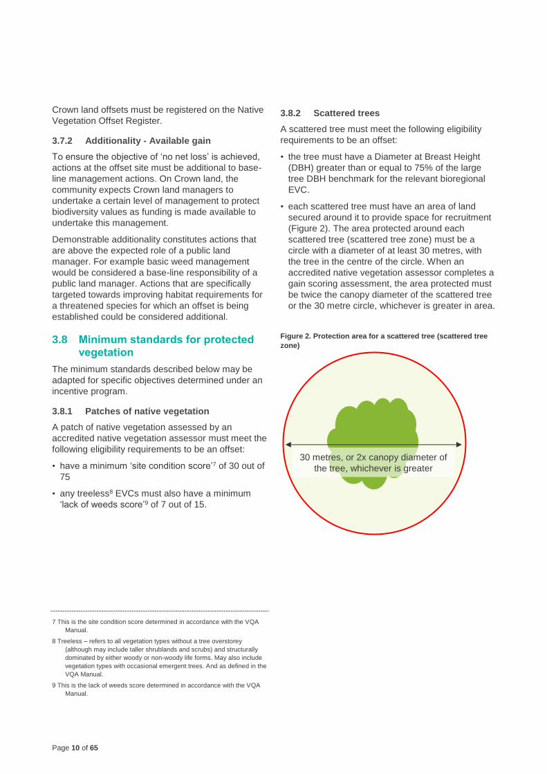
3.8.2 Scattered trees
A scattered tree must meet the following eligibility
requirements to be an offset:
• the tree must have a Diameter at Breast Height
(DBH) greater than or equal to 75% of the large
tree DBH benchmark for the relevant bioregional
EVC.
• each scattered tree must have an area of land
secured around it to provide space for recruitment
(Figure 2). The area protected around each
scattered tree (scattered tree zone) must be a
circle with a diameter of at least 30 metres, with
the tree in the centre of the circle. When an
accredited native vegetation assessor completes a
gain scoring assessment, the area protected must
be twice the canopy diameter of the scattered tree
or the 30 metre circle, whichever is greater in area.
Figure 2. Protection area for a scattered tree (scattered tree
zone)
30 metres, or 2x canopy diameter of
the tree, whichever is greater
Page 11 of 65
3.8.3 Revegetation
Revegetation must be done in accordance with the
minimum planting standard specified in Appendix 1.
Revegetation of native vegetation must meet the
following eligibility requirements to be an offset:
• revegetation must be for a woody vegetation type
• revegetation offset sites must meet the following
size requirements:
– for revegetation not abutting a patch of native
vegetation the area of revegetation must have
an area to perimeter ratio of at least 20
– for revegetation abutting a patch of native
vegetation the combined area of revegetation
plus adjacent patch of native vegetation must
have an area to perimeter ratio of at least 20.
The area to perimeter ratio is calculated by dividing
the area (metres squared) by the perimeter (metres).
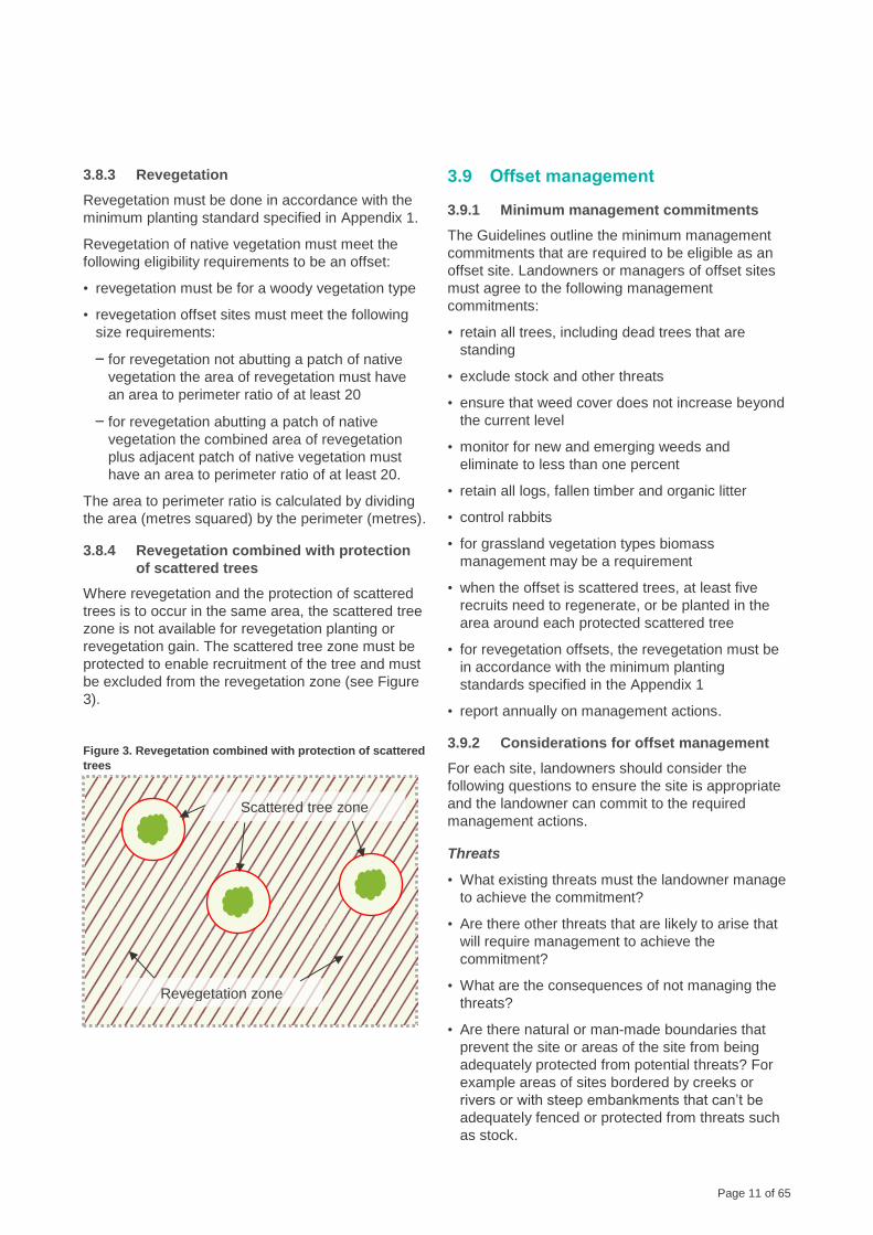
3.8.4 Revegetation combined with protection
of scattered trees
Where revegetation and the protection of scattered
trees is to occur in the same area, the scattered tree
zone is not available for revegetation planting or
revegetation gain. The scattered tree zone must be
protected to enable recruitment of the tree and must
be excluded from the revegetation zone (see Figure
3).
Figure 3. Revegetation combined with protection of scattered
trees
3.9 Offset management
3.9.1 Minimum management commitments
The Guidelines outline the minimum management
commitments that are required to be eligible as an
offset site. Landowners or managers of offset sites
must agree to the following management
commitments:
• retain all trees, including dead trees that are
standing
• exclude stock and other threats
• ensure that weed cover does not increase beyond
the current level
• monitor for new and emerging weeds and
eliminate to less than one percent
• retain all logs, fallen timber and organic litter
• control rabbits
• for grassland vegetation types biomass
management may be a requirement
• when the offset is scattered trees, at least five
recruits need to regenerate, or be planted in the
area around each protected scattered tree
• for revegetation offsets, the revegetation must be
in accordance with the minimum planting
standards specified in the Appendix 1
• report annually on management actions.
3.9.2 Considerations for offset management
For each site, landowners should consider the
following questions to ensure the site is appropriate
and the landowner can commit to the required
management actions.
Threats
• What existing threats must the landowner manage
to achieve the commitment?
• Are there other threats that are likely to arise that
will require management to achieve the
commitment?
• What are the consequences of not managing the
threats?
• Are there natural or man-made boundaries that
prevent the site or areas of the site from being
adequately protected from potential threats? For
example areas of sites bordered by creeks or
rivers or with steep embankments that can’t be
adequately fenced or protected from threats such
as stock.
Revegetation zone
Scattered tree zone
Page 12 of 65
Practicality
• What are the costs to undertake the commitment?
• How difficult is it to achieve the commitment?
• What resources would the landowner require to
achieve the commitment?
• Can the landowner undertake the commitment
using standard approaches, given the timeframes,
resources and difficulty?
• Can the landowner provide enough time and
labour to achieve the commitment?
• Does the landowner require additional advice or
guidance to achieve the commitment?
• Can the landowner undertake the commitment and
minimise collateral damage to native vegetation?
3.9.3 Site management plan
The management of a site is detailed in a site
management plan. At an offset site this is called an
offset management plan. This plan includes 10
years of management commitments for the
vegetation to be protected. It also includes ongoing
management actions to maintain the vegetation at
the improved condition, following the initial 10 year
period.
All offset sites must have an offset management
plan, except for freehold land transferred to the
Crown. Offset sites to be registered on the Native
Vegetation Credit Register (NVCR) must have a
management plan that also complies with the
standards of the NVCR.
A site management plan should be developed to
manage the specific requirements of the
vegetation to be protected, and should clearly
identify the following:
• the location of the vegetation to be protected
• security commitments agreed to by the landowner
to permanently protect the vegetation
• management commitments agreed to by the
landowner
• the gain to be achieved by the management
commitments
• activities that will be forgone within the offset area,
such as grazing, removal of all fallen timber and
standing trees
• persons responsible for implementing and
monitoring the offset management plan. If
someone other than the owner of the land is
expected to be responsible for management
actions (and associated costs) then this should be
clearly stated in the offset management plan
• time frame for implementing the offset
management plan. If the action is to be undertaken
in perpetuity, then the management plan should
state this
• annual reporting.
Templates for standard 10 year offset management
plans for first and third party offset sites are
available on the DELWP website
https://www.environment.vic.gov.au/native-
vegetation/native-vegetation.
If a landowner or land manager has committed to
controlling all high threats, the site management
plan must contain the following additional
information:
• identification of all on-site threats (e.g. threats from
introduced animals including deer, wild pigs and
goats or overgrazing by native herbivores
including kangaroos, wallabies and possums,
inappropriate fire or flood regime, other threats as
identified)
• the level of risk of each threat to improvement in
the tree canopy recruitment and condition,
understorey cover, diversity and recruitment and
organic litter cover improvement
• ongoing monitoring for presence, activity and
disturbance from introduced animals and
overgrazing by native herbivores
• a strategic and integrated program of management
and control actions to effectively eliminate all
introduced animals and adequately control
overgrazing by native herbivores. The program
must be integrated to ensure all identified threats
are addressed and managed through coordinated
actions and at multiple times throughout each
management year to ensure the control of all
threats is sustained. The land manager must be
able to demonstrate that the control actions can be
maintained in the long-term
• controlling introduced animals and native
herbivores must be through the necessary
approvals required under relevant legislation
• control actions must be appropriate for the threat
and location (e.g. for introduced animals and
native herbivores shooting may be inappropriate in
some locations, extensive exclusion fencing is
likely not practical or achievable in the long term).
Page 13 of 65
To generate gain at a site, landowners must agree
to minimum commitments for security and land
management. This section summarises the
minimum commitments for prior management,
security, maintenance and improvement gains.
The requirements for offset site eligibility (section 3)
generally coincide with the minimum commitments
required to generate prior management, security and
maintenance gain, along with some improvement gain.
If a proposed offset site meets the eligibility
requirements to be an offset, then it is likely that gain
can be achieved.
Before entering in to an agreement to secure and
manage a site, landowners should have an
understanding of what the commitments entail, and
whether they are appropriate for their site (see
section 5).
It is particularly important that landowners understand
their security and land management obligations as the
agreed commitments will form part of the security
agreement. Failure to undertake the commitments
would breach the security agreement and could result
in enforcement action to rectify the breach.
The commitments to generate gain for protected
vegetation depend on the vegetation type. The
following vegetation types are considered when
calculating gain:
• Patch of native vegetation. A patch of native
vegetation is further broken down in to four broad
vegetation types:
– Woody vegetation
– High rainfall Victorian Volcanic Plains or
Gippsland Plains grassland vegetation
– Other grassland vegetation
– Non-woody wetland vegetation
• Scattered tree
• Revegetation.
4.1 Prior management gain
4.1.1 Freehold land
The minimum commitment to generate prior
management gain on freehold land is to protect the
vegetation using one of the approved security
options described in section 4.2.1.
Appendix 2A explains how to calculate the amount
of prior management gain that can be generated on
freehold land.
4.1.2 Crown land
Crown land is required to be protected and managed
in accordance with its reserve status. Therefore,
prior management gain is not available on Crown
land.
4.2 Security gain
4.2.1 Freehold land
Options to generate security gain on freehold land
are described in Table 1. Appendix 2B explains how
to calculate the amount of security gain that can be
generated on freehold land.
All third party offset sites must be recorded on the
Native Vegetation Credit Register (NVCR). Third
party offset sites transferred to the Crown must be
recorded on the DELWP Offset Register.
4.2.2 Crown land
The amount of security gain available on Crown land
depends on the current Crown land category of the
site. Crown land can be in any of three categories
depending on the legal management responsibilities
for conservation. These categories are described in
Table 2 and include:
• conservation as primary purpose
• multiple purposes which includes conservation
(but not primary purpose)
• other purposes.
Minimum commitment options to generate security
gain on Crown land are described in Table 3.
Appendix 3 explains how to calculate the amount of
security gain that can be generated on Crown land.
4 Minimum commitments to generate gain
Page 14 of 65
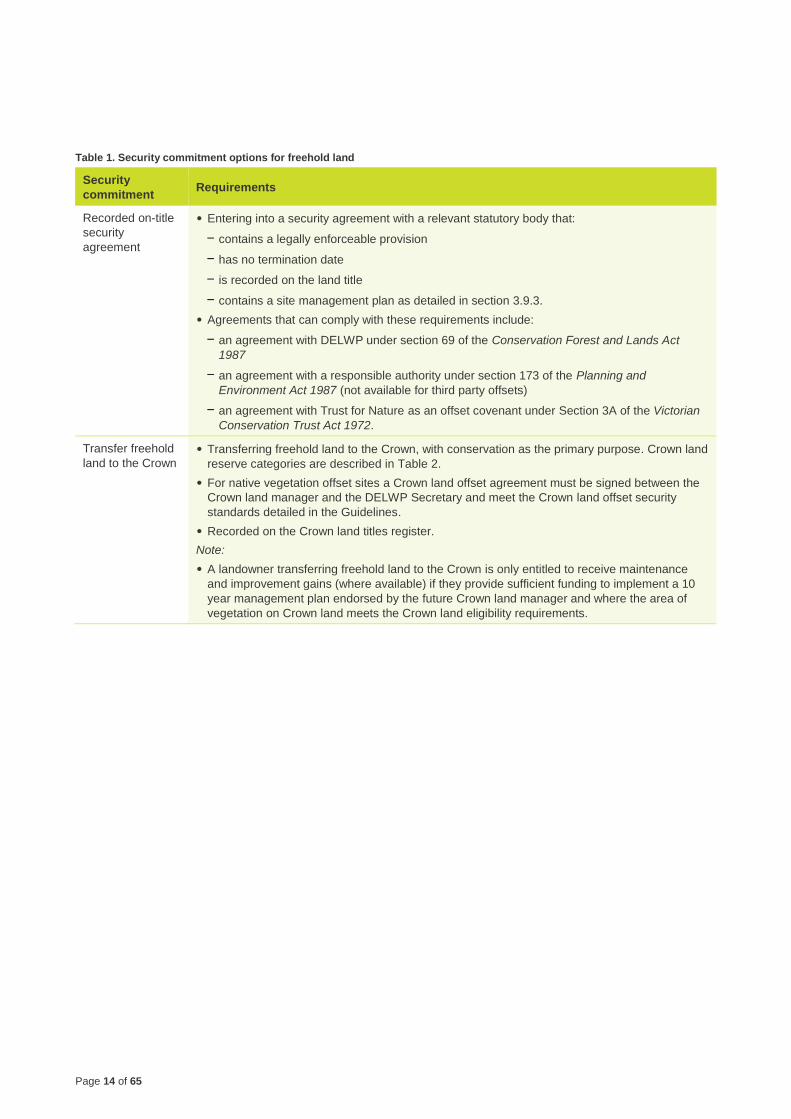
Table 1. Security commitment options for freehold land
Security
commitment Requirements
Recorded on-title
security
agreement
• Entering into a security agreement with a relevant statutory body that:
– contains a legally enforceable provision
– has no termination date
– is recorded on the land title
– contains a site management plan as detailed in section 3.9.3.
• Agreements that can comply with these requirements include:
– an agreement with DELWP under section 69 of the Conservation Forest and Lands Act
1987
– an agreement with a responsible authority under section 173 of the Planning and
Environment Act 1987 (not available for third party offsets)
– an agreement with Trust for Nature as an offset covenant under Section 3A of the Victorian
Conservation Trust Act 1972.
Transfer freehold
land to the Crown
• Transferring freehold land to the Crown, with conservation as the primary purpose. Crown land
reserve categories are described in Table 2.
• For native vegetation offset sites a Crown land offset agreement must be signed between the
Crown land manager and the DELWP Secretary and meet the Crown land offset security
standards detailed in the Guidelines.
• Recorded on the Crown land titles register.
Note:
• A landowner transferring freehold land to the Crown is only entitled to receive maintenance
and improvement gains (where available) if they provide sufficient funding to implement a 10
year management plan endorsed by the future Crown land manager and where the area of
vegetation on Crown land meets the Crown land eligibility requirements.
Page 15 of 65
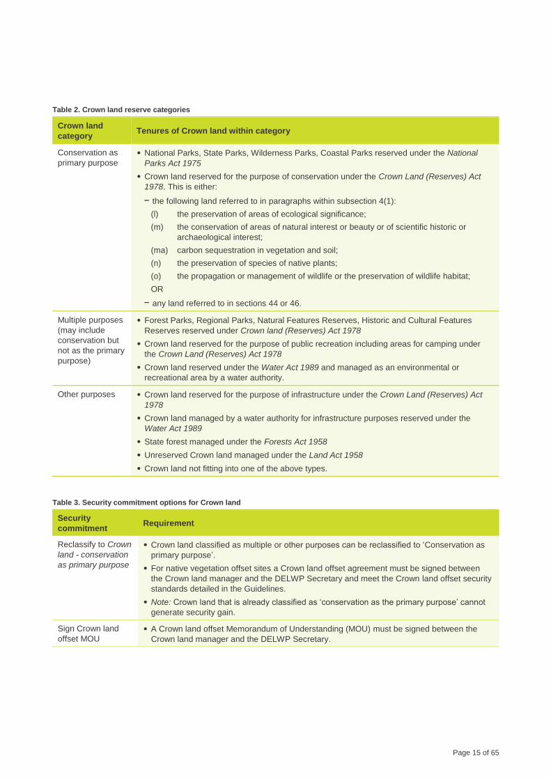
Table 2. Crown land reserve categories
Crown land
category Tenures of Crown land within category
Conservation as
primary purpose
• National Parks, State Parks, Wilderness Parks, Coastal Parks reserved under the National
Parks Act 1975
• Crown land reserved for the purpose of conservation under the Crown Land (Reserves) Act
1978. This is either:
– the following land referred to in paragraphs within subsection 4(1):
(l) the preservation of areas of ecological significance;
(m) the conservation of areas of natural interest or beauty or of scientific historic or
archaeological interest;
(ma) carbon sequestration in vegetation and soil;
(n) the preservation of species of native plants;
(o) the propagation or management of wildlife or the preservation of wildlife habitat;
OR
– any land referred to in sections 44 or 46.
Multiple purposes
(may include
conservation but
not as the primary
purpose)
• Forest Parks, Regional Parks, Natural Features Reserves, Historic and Cultural Features
Reserves reserved under Crown land (Reserves) Act 1978
• Crown land reserved for the purpose of public recreation including areas for camping under
the Crown Land (Reserves) Act 1978
• Crown land reserved under the Water Act 1989 and managed as an environmental or
recreational area by a water authority.
Other purposes • Crown land reserved for the purpose of infrastructure under the Crown Land (Reserves) Act
1978
• Crown land managed by a water authority for infrastructure purposes reserved under the
Water Act 1989
• State forest managed under the Forests Act 1958
• Unreserved Crown land managed under the Land Act 1958
• Crown land not fitting into one of the above types.
Table 3. Security commitment options for Crown land
Security
commitment Requirement
Reclassify to Crown
land - conservation
as primary purpose
• Crown land classified as multiple or other purposes can be reclassified to ‘Conservation as
primary purpose’.
• For native vegetation offset sites a Crown land offset agreement must be signed between
the Crown land manager and the DELWP Secretary and meet the Crown land offset security
standards detailed in the Guidelines.
• Note: Crown land that is already classified as ‘conservation as the primary purpose’ cannot
generate security gain.
Sign Crown land
offset MOU
• A Crown land offset Memorandum of Understanding (MOU) must be signed between the
Crown land manager and the DELWP Secretary.
Page 16 of 65
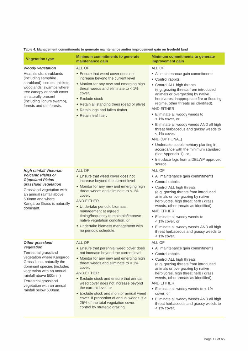
4.3 Maintenance gain and improvement gain
4.3.1 Freehold land
To generate maintenance and improvement gains,
landowners must first agree to protect the vegetation
using one of the approved security options
described in Table 1.
The minimum commitments required to generate
maintenance gain and improvement gain on freehold
land are listed in Table 4. To generate maintenance
gain, landowners must agree to all maintenance
gain minimum commitments for the relevant
vegetation type. Landowners can also generate
improvement gain by agreeing to the improvement
gain minimum commitments. To generate gain, all
commitments must be implemented as described in
section 5.
Appendix 2C explains how to calculate the amount
of maintenance gain and improvement gain that can
be generated in each vegetation type on freehold
land.
Overlays
Gain is only available where the commitments are
higher than the landowner’s current legal
management responsibilities (duty of care). Overlays
increase the legal management responsibilities and
therefore affect the availability of maintenance gain.
For example, under an Environmental Significance
Overlay (ESO) the landowner has a duty of care to
retain all standing trees. Therefore, this commitment
does not generate maintenance gain for the ‘tree
canopy cover’ component of the habitat score.
Maintenance gains are available for the ‘large trees’
component of the habitat score, including where an
overlay is present. This is to recognise the important
role large trees contribute to habitat and services for
biodiversity, their age that they are difficult to replace
in the short term.
To determine the availability of maintenance gains
on freehold land, first determine whether the area is
covered by one of the following overlays:
Environmental Significance Overlay (ESO),
Vegetation Protection Overlay (VPO), Significant
Landscape Overlay (SLO), Erosion Management
Overlay (EMO), Salinity Management Overlay
(SMO), Bushfire Management Overlay (BMO).
Check the management restrictions that apply to
land under the overlay. The following lists the
management restrictions that may apply and how
the restriction affects the availability of maintenance
and improvement gain for components of the habitat
score:
• Restriction 1: Not permitted to graze with domestic
stock – no maintenance gain for ‘understorey’ or
‘recruitment’.
• Restriction 2: Not permitted to remove trees - no
maintenance gain for ‘tree canopy cover’.
• Restriction 3: Not permitted to remove dead
vegetation – no maintenance gain for ‘organic
litter’ or ‘logs’.
• Restriction 4: Requirement for regular fuel
reduction - no maintenance or improvement gain
for ‘understorey’, ‘recruitment’, ‘organic litter’ or
‘logs’.
Transferring freehold land to the Crown
If transferring freehold land to the Crown is the
chosen security option, a landowner is only entitled
to receive maintenance and improvement gains
(where available) if they provide sufficient funding to
implement a 10 year management plan endorsed by
the future Crown land manager and where the area
of vegetation on Crown land meets standards
detailed in the Guidelines.
If a funded management plan is not provided, the
future Crown land manager can generate
maintenance and improvement gains by funding and
implementing a 10 year management plan
incorporated into the Crown land offset MOU, at the
time the Crown land offset MOU is signed.
Page 17 of 65
Table 4. Management commitments to generate maintenance and/or improvement gain on freehold land
Vegetation type Minimum commitments to generate
maintenance gain
Minimum commitments to generate
improvement gain
Woody vegetation
Heathlands, shrublands
(including samphire
shrubland), scrubs, thickets,
woodlands, swamps where
tree canopy or shrub cover
is naturally present
(including lignum swamp),
forests and rainforests.
ALL OF
• Ensure that weed cover does not
increase beyond the current level
• Monitor for any new and emerging high
threat weeds and eliminate to < 1%
cover.
• Exclude stock
• Retain all standing trees (dead or alive)
• Retain logs and fallen timber
• Retain leaf litter.
ALL OF
• All maintenance gain commitments
• Control rabbits
• Control ALL high threats
(e.g. grazing threats from introduced
animals or overgrazing by native
herbivores, inappropriate fire or flooding
regime, other threats as identified).
AND EITHER
• Eliminate all woody weeds to
< 1% cover, or
• Eliminate all woody weeds AND all high
threat herbaceous and grassy weeds to
< 1% cover.
AND (OPTIONAL)
• Undertake supplementary planting in
accordance with the minimum standard
(see Appendix 1), or
• Introduce logs from a DELWP approved
source.
High rainfall Victorian
Volcanic Plains or
Gippsland Plains
grassland vegetation
Grassland vegetation with
an annual rainfall above
500mm and where
Kangaroo Grass is naturally
dominant.
ALL OF
• Ensure that weed cover does not
increase beyond the current level
• Monitor for any new and emerging high
threat weeds and eliminate to < 1%
cover.
AND EITHER
• Undertake periodic biomass
management at agreed
timing/frequency to maintain/improve
native vegetation condition, or
• Undertake biomass management with
no periodic schedule.
ALL OF
• All maintenance gain commitments
• Control rabbits
• Control ALL high threats
(e.g. grazing threats from introduced
animals or overgrazing by native
herbivores, high threat herb / grass
weeds, other threats as identified).
AND EITHER
• Eliminate all woody weeds to
< 1% cover, or
• Eliminate all woody weeds AND all high
threat herbaceous and grassy weeds to
< 1% cover.
Other grassland
vegetation
Terrestrial grassland
vegetation where Kangaroo
Grass is not naturally the
dominant species (includes
vegetation with an annual
rainfall above 500mm)
Terrestrial grassland
vegetation with an annual
rainfall below 500mm.
ALL OF
• Ensure that perennial weed cover does
not increase beyond the current level
• Monitor for any new and emerging high
threat weeds and eliminate to < 1%
cover.
AND EITHER
• Exclude stock and ensure that annual
weed cover does not increase beyond
the current level, or
• Exclude stock and monitor annual weed
cover. If proportion of annual weeds is ≥
25% of the total vegetation cover,
control by strategic grazing.
ALL OF
• All maintenance gain commitments
• Control rabbits
• Control ALL high threats
(e.g. grazing threats from introduced
animals or overgrazing by native
herbivores, high threat herb / grass
weeds, other threats as identified).
AND EITHER
• Eliminate all woody weeds to < 1%
cover, or
• Eliminate all woody weeds AND all high
threat herbaceous and grassy weeds to
< 1% cover.
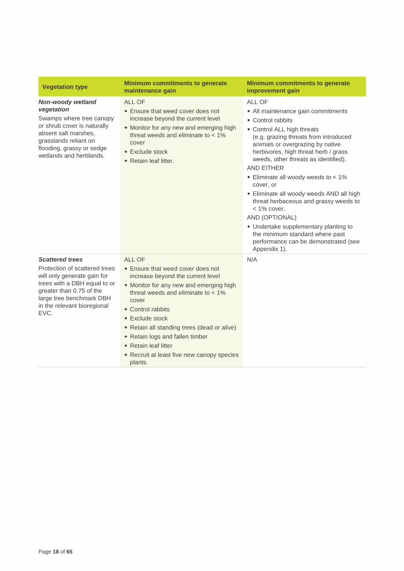
Page 18 of 65
Vegetation type Minimum commitments to generate
maintenance gain
Minimum commitments to generate
improvement gain
Non-woody wetland
vegetation
Swamps where tree canopy
or shrub cover is naturally
absent salt marshes,
grasslands reliant on
flooding, grassy or sedge
wetlands and herblands.
ALL OF
• Ensure that weed cover does not
increase beyond the current level
• Monitor for any new and emerging high
threat weeds and eliminate to < 1%
cover
• Exclude stock
• Retain leaf litter.
ALL OF
• All maintenance gain commitments
• Control rabbits
• Control ALL high threats
(e.g. grazing threats from introduced
animals or overgrazing by native
herbivores, high threat herb / grass
weeds, other threats as identified).
AND EITHER
• Eliminate all woody weeds to < 1%
cover, or
• Eliminate all woody weeds AND all high
threat herbaceous and grassy weeds to
< 1% cover.
AND (OPTIONAL)
• Undertake supplementary planting to
the minimum standard where past
performance can be demonstrated (see
Appendix 1).
Scattered trees
Protection of scattered trees
will only generate gain for
trees with a DBH equal to or
greater than 0.75 of the
large tree benchmark DBH
in the relevant bioregional
EVC.
ALL OF
• Ensure that weed cover does not
increase beyond the current level
• Monitor for any new and emerging high
threat weeds and eliminate to < 1%
cover
• Control rabbits
• Exclude stock
• Retain all standing trees (dead or alive)
• Retain logs and fallen timber
• Retain leaf litter
• Recruit at least five new canopy species
plants.
N/A
Page 19 of 65
Vegetation type Minimum commitments to generate
maintenance gain
Minimum commitments to generate
improvement gain
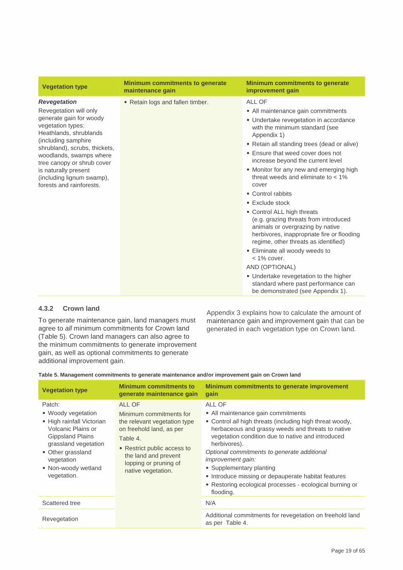
Revegetation
Revegetation will only
generate gain for woody
vegetation types:
Heathlands, shrublands
(including samphire
shrubland), scrubs, thickets,
woodlands, swamps where
tree canopy or shrub cover
is naturally present
(including lignum swamp),
forests and rainforests.
• Retain logs and fallen timber. ALL OF
• All maintenance gain commitments
• Undertake revegetation in accordance
with the minimum standard (see
Appendix 1)
• Retain all standing trees (dead or alive)
• Ensure that weed cover does not
increase beyond the current level
• Monitor for any new and emerging high
threat weeds and eliminate to < 1%
cover
• Control rabbits
• Exclude stock
• Control ALL high threats
(e.g. grazing threats from introduced
animals or overgrazing by native
herbivores, inappropriate fire or flooding
regime, other threats as identified)
• Eliminate all woody weeds to
< 1% cover.
AND (OPTIONAL)
• Undertake revegetation to the higher
standard where past performance can
be demonstrated (see Appendix 1).
4.3.2 Crown land
To generate maintenance gain, land managers must
agree to all minimum commitments for Crown land
(Table 5). Crown land managers can also agree to
the minimum commitments to generate improvement
gain, as well as optional commitments to generate
additional improvement gain.
Appendix 3 explains how to calculate the amount of
maintenance gain and improvement gain that can be
generated in each vegetation type on Crown land.
Table 5. Management commitments to generate maintenance and/or improvement gain on Crown land
Vegetation type Minimum commitments to
generate maintenance gain
Minimum commitments to generate improvement
gain
Patch:
• Woody vegetation
• High rainfall Victorian
Volcanic Plains or
Gippsland Plains
grassland vegetation
• Other grassland
vegetation
• Non-woody wetland
vegetation.
ALL OF
Minimum commitments for
the relevant vegetation type
on freehold land, as per
Table 4.
• Restrict public access to
the land and prevent
lopping or pruning of
native vegetation.
ALL OF
• All maintenance gain commitments
• Control all high threats (including high threat woody,
herbaceous and grassy weeds and threats to native
vegetation condition due to native and introduced
herbivores).
Optional commitments to generate additional
improvement gain:
• Supplementary planting
• Introduce missing or depauperate habitat features
• Restoring ecological processes - ecological burning or
flooding.
Scattered tree N/A
Revegetation Additional commitments for revegetation on freehold land
as per Table 4.
Page 20 of 65
Maintenance and improvement gains are calculated
separately for each component of the habitat score:
large trees, tree canopy cover, understorey, lack of
weeds, recruitment, organic litter and logs.
The following sections provide information on how
the relevant management commitments contribute to
the generation of gain in each habitat component.
Proposing other management commitments
Other management commitments may require
further study through scientific research to determine
their effectiveness and certainty. This may include
commitments for offsets of particular threatened
species. The commitments listed in this document
will improve the condition of vegetation, which in turn
will increase the condition of the habitat for the
majority of species. However, some other
commitments may be particularly effective in
increasing the condition of rare or threatened
species habitat. This habitat may be a particular
habitat component or another habitat attribute which
is not recorded in the vegetation quality assessment.
If it is not recorded in the vegetation quality
assessment, a clear method of assessing the gain
and the relationship with vegetation quality
assessment method would be required.
5.1 Large trees
Retain all standing trees
Maintenance gains can be generated for the large
tree component where a land manager is currently
entitled to remove large trees and where the land
manager is prepared to forego this entitlement for
the 10 year management period or in the case of
offsets, where this entitlement is permanently
surrendered.
Although under Clause 52.17 of the Victoria
Planning Provisions a permit is required to remove
standing living and dead large trees, without
permanent protection their ongoing security and
persistence is not guaranteed. Therefore, to
recognise the important role large trees contribute to
habitat and services for biodiversity and the age and
difficulty to replace them in the short term,
maintenance gains are available for large trees on
freehold land, where they are permanently
protected.
In woody vegetation, maintenance gain scoring for
the large tree component is risk and proportionate
based and recognises the risk of loss of large trees
is greatest where there are fewer large trees within
smaller areas. Therefore, the amount of
maintenance gain available for a habitat zone
depends on the total number of hectares of native
vegetation (patch only) on the same property
(including the habitat zone to be protected).
Due to the time taken to ‘grow a large tree’, no
improvement gains are possible for large trees over
the 10 year management period.
5.2 Tree canopy cover
Retain all standing trees
Maintenance gains can be generated for the tree
canopy cover component by retaining all standing
trees. See section 5.1 for more information.
In woody vegetation, maintenance gain scoring for
the tree canopy cover component is risk and
proportionate based and recognises the risk of loss
of large trees is greatest where there are fewer large
trees within smaller areas. Section 5.1 provides
further detail.
Maintenance gain for tree canopy cover is only
available where the site is on contiguous land in the
same ownership with an area equal to or more than 10
hectares.
Control all high threats
Improvement gain can be generated for the tree
canopy cover component if a landowner commits to
controlling all high threats. This recognises that 10
years of threat management may result in partial
recovery of the tree canopy cover where this is
currently below benchmark cover.
Under most of the gain scoring scenarios outlined in
Appendix 2 the qualification for improvement gains
is predicated on landowners committing to
controlling all high threats to native vegetation
condition improvement. This includes typical high
threats to soil structure, natural water flow,
vegetation condition and the recruitment cycle.
Examples of typical high threats to improvement
includes, but is not limited to grazing and
disturbance threats from introduced animals (non-
domestic animals) such as deer, goats, wild pigs
and horses or overgrazing by native herbivores
including kangaroos, wallabies and possums, high
threats weeds, threats from inappropriate fire or
flood regime and other threats as identified. For
example:
• sites where deer are known to be in high numbers
including in the surrounding landscape and pose a
significant threat to improvement in habitat
components including the tree canopy cover and
5 Description of management commitments
Page 21 of 65
woody species recruitment, understorey life forms
and organic litter cover, then it is unlikely that
improvement in these components will be
achievable or sustainable in the long term at the
site. As such improvement gains is not available
for these habitat components.
• sites where deer may be present, but are in quite
low numbers and the risk from deer is a much
lower threat, then where the landowner can
commit to monitor and manage the threat
adequately in the long-term through a
management plan that outlines an integrated
program of ongoing monitoring, management and
control actions as outlined above, improvement
gains can be assessed as being available for
these habitat components.
Improvement gain in the tree canopy cover component
is only available where all high threats can be
adequately controlled. Where the threat is assessed as
too great and unlikely to be able to be controlled, or the
landowner cannot commit to managing the threat in the
long-term, then improvement in tree canopy cover is
unlikely and improvement gain is not available.
If a land manager has committed to controlling all
high threats, the site management plan must
contain the additional information described in
section 3.9.3.
Control rabbits
Improvement gain can be generated for the tree
canopy cover component if a land manager commits
to management of rabbits. The Catchment and Land
Protection Act 1994 lists rabbits as an established
pest animal and requires that all landowners take
reasonable steps to prevent the spread of, and as
far as possible eradicate, established pest animals
on their land. It should be noted that landowners
cannot rely on myxomatosis and the rabbit
calicivirus diseases alone to effectively control
rabbits. Integrated rabbit control should be
implemented to control rabbits in native vegetation.
In native vegetation integrated rabbit control should
include a combination of:
• fumigating and hand collapsing warrens
• destruction of surface harbour
• baiting
• shooting where appropriate.
Integrated rabbit control must be carefully
implemented in native vegetation to ensure that the
condition of native vegetation or habitat for
indigenous species is not degraded.
Supplementary planting
A land manager can commit to supplementary
planting of native vegetation to generate
improvement gain, but only if supplementary
planting is appropriate for the specific site
conditions. In some cases, it may be considered
desirable to introduce life forms and/or species that
would have occurred on a site but are now absent.
To determine if supplementary planting is
appropriate, assessors should consider whether key
woody life-forms such as small shrubs, medium
shrubs, understorey trees or canopy trees are
missing, and if there is available space for planting
(bare ground outside drip line of canopy trees).
Supplementary planting must meet the standards
outlined in the minimum standard for revegetation
and supplementary planting (Appendix 1), calculated
for the available space for supplementary planting in
the zone. The species, plant numbers and areas to
be planted must be detailed in the site management
plan.
Supplementary planting is only available where
benchmark life forms are missing, and can reasonably
be re-introduced, as determined by DELWP on a case-
by-case basis.
Improvement gain for supplementary planting is
generally only available in woody vegetation and can
be generated for planting canopy tree species where
there is no tree canopy cover (score is 0), or
understorey species where the understorey score is low
(0 or 5).
5.3 Understorey
Exclude stock
Maintenance gain can be generated for the
understorey component where a land manager is
currently entitled to graze the area with domestic
stock and where they are prepared to forego this
entitlement for the 10 year management period or in
the case of offsets, where this entitlement is
permanently surrendered. Land managers will also
need to ensure that the weed cover does not
increase beyond current levels following grazing
control in order to qualify for understorey
maintenance gain. Weed control is discussed below.
Page 22 of 65
Control weeds
Control weeds (general)
To generate maintenance gain, land managers must
undertake weed control. The focus of weed control
varies depending on the vegetation type. Specific
controls for woody weeds and annual weeds are
discussed below.
Landowners must meet their obligations under the
Catchment and Land Protection Act 1994 with respect
to eradicating regionally prohibited weeds and
preventing the growth and spread of regionally
controlled weeds.
Control of Catchment and Land Protection Act 1994
weeds is part of the landowner’s legal management
responsibilities (duty of care), even without an offset
site agreement. In the context of managing native
vegetation, weeds are not restricted to those listed
under the Act. As such, eradication of regionally
prohibited and control of regionally controlled
Catchment and Land Protection Act 1994 weeds alone
does not generate site gain.
Landowners and assessors should consider how the
proposed method for managing weeds may impact
native plants and animals. In some instances, a
landowner may not be able to commit to eliminating
weed species if there is potential to cause significant
damage to native plants and animals. On some
sites, weeds provide habitat for native animals and
therefore removal of weed species can be
detrimental. In most cases, the preferred approach
is to remove the weeds and progressively plant
suitable indigenous species in their place. The
management plan should describe how habitat will
be progressively replaced as the weeds are
removed.
In some cases, high threat weeds may be
particularly difficult to eliminate or control. This could
be due to the species being well-established on a
site or due to its biology. For example, it is often
difficult to control Chilean Needle-grass once it has
become established. To determine if elimination to
less than 1% cover will be feasible, the assessor
should consider the:
• current cover of the high threat weed species
• predicted response of the species to the control
methods
• size of the area to be managed
• extent of high threat weeds in the vicinity and their
potential to invade the site
• landowner’s capacity to effectively implement the
control method.
Where a landowner has committed to eliminating all
high threat weeds, all high threat weeds observed
on site must be listed in the site management plan
with a description about how they will be eliminated.
High threat weeds are determined as per a
Vegetation Quality Assessment. That is, any
introduced species (including non-indigenous
natives) with the ability to out-compete and
substantially reduce one or more indigenous life
forms in the longer term. All perennial weeds and
those listed as high impact in the bioregional
EVC benchmarks should be considered high
threat, and in some cases annual weeds may
also be considered high threat.
Control woody weeds
Improvement gain can also be generated by
agreeing to manage woody weeds and high threat
herbaceous and grassy weeds. The amount of
improvement gain available will depend on the
current lack of weeds score and the commitment
that the landowner agrees to. For habitat zones
where the cover of high threat weeds is higher (lack
of weeds score of < 9) landowners are unlikely to be
able to eliminate all high threat herbaceous and
grassy weeds, but generally should be able to
eliminate all woody weeds. Consequently,
landowners only have a choice of one commitment
where the lack of weeds score is < 9: Eliminate all
woody weeds to < 1% cover.
The option to eliminate all woody weeds AND all high
threat herbaceous and grassy weeds to < 1% cover is
not considered feasible if the current ‘Lack of weeds’
score is <9.
Control annual weeds
In Other grassland vegetation, improvement gain
can be generated by agreeing to manage annual
weeds. Control of annual grassy weeds may be
difficult in other grassland vegetation (< 500 mm
rainfall) where the existing seed bank of annual
weeds may be considerable. Landowners may use
strategic grazing as a tool to control annual weeds
and supplement it with targeted weed control.
Strategic grazing can be particularly useful in
reducing flowering of annual weeds when applied at
the right time. When successfully applied, strategic
grazing can deplete the seed source of annual
weeds to the point where the landowner can control
the annual weeds by targeted weed control alone.
This is also the long-term goal and preferred
Page 23 of 65
approach to managing and maintaining the native
vegetation condition at the site.
The general strategy for reducing flowering of
annual weeds is to introduce a high density of sheep
for a short period before flowering and seeding. It
should be noted that strategic grazing is less
desirable than targeted weed control, as it carries a
much higher risk of irreversible damage from stock.
Many native species also flower at the same time as
annual weeds. As such, strategic grazing will
inevitably reduce seed set of native species as well
as annual weeds.
Strategic grazing should only be implemented when
cover of annual weeds is above 25% and where native
species won’t be adversely impacted over the long
term.
When deciding whether to use strategic grazing for
control of annual weeds in other grassland
vegetation, assessors should carefully analyse the
positive and negative effects of grazing on habitat
condition and species diversity. In particular, they
should consider:
• the tolerance of both exotic and native species to
grazing
• the palatability of the exotic species compared to
native species found on site
• the flowering season and the seed source of exotic
and native species
• the likely response to grazing of exotic and native
species (particularly native herbs and smaller life
forms)
• when strategic grazing is likely to be required
• the capacity of the landowner and the resources
required to undertake strategic grazing
• the methods for monitoring changes in weed cover
and identifying when cover of annual weeds
reaches 25%
• monitoring and keeping records of the number of
sheep and duration of grazing as well as impact on
native species.
Biomass management
In High rainfall Victorian Volcanic Plains or
Gippsland Plains grassland vegetation, maintenance
gain can be generated by agreeing to manage
biomass. In this vegetation type, thatching by
Kangaroo Grass (Themeda triandra) can lead to
reductions in plant populations and species diversity.
As Kangaroo Grass leaves wither and dry they
thatch over the surrounding open spaces, reducing
the amount of area available for recruitment of other
native species. As a result, biomass management is
generally required in high rainfall grasslands where
Kangaroo Grass is dominant.
The objective of biomass management is to maintain
inter-tussock spaces for herb recruitment, and
improve species richness, diversity of life forms and
variety of habitats.
Grazing and burning are the most common
techniques to manage biomass. Slashing and
removal of thatch is also an option provided there is
strict slasher hygiene to ensure that no weeds are
transferred. Where highly invasive environmental
weeds such as Nassella species are present
slashing should not occur. The choice of technique
should take into account the past management of
the site. For example, a grassland community that
was periodically burnt in the past may contain
species that are sensitive to grazing.
Landowners should monitor the effects of biomass
management to allow for management approaches
to be modified to ensure species diversity is
maintained and structural diversity is improved.
When deciding which biomass management
technique to use, assessors should consider:
• the potential for ‘thatching over’ of Kangaroo
Grass
• the past management of the grassland
• the tolerance of both exotic and native species to
grazing or burning
• the flowering season and the seed source of both
exotic and native species
• the optimum frequency or timing of biomass
management
• the capacity of the landowner and the resources
required to undertake the biomass management
technique
• the methods for monitoring changes in vegetation
cover due to grazing to identify when it is
approaching 70%.
Most native species in a high rainfall grassland
environment require biomass management to open
up available space (bare ground) to enable
germination. However, native plants benefit from a
break in grazing while flowering and seeding. For
most high rainfall volcanic plains or Gippsland plains
grasslands the best time to graze is usually from late
summer to late winter, on an annual basis. However,
Page 24 of 65
this will depend on site conditions and rainfall
patterns. In some high rainfall volcanic plains or
Gippsland plains grassland sites, the vegetation may
have been modified to the point where Kangaroo
Grass is absent or only a minor component. On
these sites, introducing stock on an annual basis for
biomass management may be detrimental to
vegetation condition and species diversity because
grazing animals may selectively graze the smaller
(more palatable) native species. When deciding
whether to use grazing for biomass management
where Kangaroo Grass is not clearly dominant,
assessors should carefully assess the potential
positive and negative effects of grazing on habitat
condition and species diversity and decide if an
alternative biomass management technique may be
more appropriate.
Where grazing is the method used for biomass
management, to minimise significant impacts on native
plants and animals from grazing, landowners must
maintain the total vegetation cover above 70%.
If it is determined that biomass management is still
important in maintaining diversity and reducing
Kangaroo Grass thatch, but annual grazing is likely
to result in a decline in diversity, the following
options should be considered:
• irregular grazing to control biomass build-up (two
to five years between grazing events) after
monitoring by a suitably qualified ecologist
• mosaic burning (scheduled every two to five years)
after monitoring by a suitably qualified ecologist
• slashing and removing thatch, after monitoring by
a suitably qualified ecologist.
If using burning, landowners must only undertake
mosaic burns. Mosaic burning is when only a section
of the site is burned at a time, so that each section is
burned only once every two to five years. When
burning, landowners must abide by local laws and
Country Fire Authority (CFA) restrictions, obtaining
appropriate permits as necessary.
The optimal season and frequency for burning high
rainfall volcanic plains or Gippsland plains
grasslands can vary and depends on the dominant
species. For sites dominated by Kangaroo Grass
burning every one to two years may be suitable. For
sites dominated by species not prone to thatching
every two to five years may be suitable. In general,
burning in autumn is preferred to minimise the
impact on native species flowering and setting seed
(although burning in spring can sometimes be
beneficial). The timing and frequency of burns will
vary on each site and must be decided on a case by
case basis. Landowners should also consider the
impacts of burning the grassland on habitat for
native animals including threatened species where
present.
Landowners may generate site gain if they
undertake biomass management (by grazing,
mosaic burning or slashing and removal of thatch) at
an agreed time and frequency. A reduced amount of
site gain may be generated if biomass management
is undertaken without an agreed schedule. If the
landowner is considering managing biomass without
a schedule, the assessor and landowner should
discuss:
• the relative benefits of periodic biomass
management at an agreed timing and frequency
compared with biomass management with no
schedule
• the methods for monitoring changes in vegetation
cover and determining when biomass
management should begin or end
• where using grazing, monitoring to ensure that
total vegetation cover does not fall below 70% and
a strategy for removing and excluding stock when
this occurs
• the strategy for biomass management.
Control all high threats
Improvement gain can be generated for the
understorey component if a land manager commits
to management of all high threats. See section 5.2
for more details.
Improvement gain in the understorey component is only
available where all high threats can be adequately
controlled. Where the threat is assessed as too great
and unlikely to be able to be controlled, or the
landowner cannot commit to managing the threat in the
long-term, then improvement in the understorey is
unlikely and improvement gain is not available.
If a land manager has committed to controlling all
high threats, the site management plan must
contain the additional information described in
section 3.9.3.
Control rabbits
In some vegetation types, improvement gain can be
generated for the understorey component if a land
manager commits to management of rabbits. See
section 5.2 for more details.
Supplementary planting
A land manager can commit to supplementary
planting of native vegetation to generate
Page 25 of 65
improvement gain for the understorey component,
but only if supplementary planting is appropriate for
the specific site conditions. See section 5.2 for more
information.
5.4 Lack of weeds
Maintenance gain is not applicable to the ‘lack of
weeds’ component although ensuring that weed
cover does not increase beyond current levels is a
requirement to qualify for maintenance gains for
other habitat components.
Control weeds
Improvement gain can be generated for the lack of
weeds component if a land manager commits to
management of weeds, including woody weeds and
high threat herbaceous and grassy weeds. See
section 5.3 for more details about weed control.
5.5 Recruitment
Exclude stock
Maintenance gain can be generated for the
recruitment component where a land manager is
currently entitled to graze the area with domestic
stock and where they are prepared to forego this
entitlement for the 10 year management period or in
the case of offsets, where this entitlement is
permanently surrendered. Land managers will also
need to ensure that the weed cover does not
increase beyond current levels following grazing
control in order to qualify for recruitment
maintenance gain.
Control weeds
To generate maintenance gain for the recruitment
component, land managers must undertake weed
control.
Improvement gain can be generated if a land
manager commits to management of woody weeds
and high threat herbaceous and grassy weeds.
Improvement gain can be generated in Other
grassland vegetation for the recruitment component
if a land manager commits to management of annual
weeds.
See section 5.3 for more details about weed control.
Biomass management
In High rainfall Victorian Volcanic Plains or
Gippsland Plains grassland vegetation, maintenance
gain can be generated by agreeing to manage
biomass. See section 5.3 for more details.
Control all high threats
Improvement gain can be generated for the
recruitment component if a land manager commits to
management of all high threats. See section 5.2 for
more details.
Improvement gain in the recruitment component is only
available where all high threats can be adequately
controlled. Where the threat is assessed as too great
and unlikely to be able to be controlled, or the
landowner cannot commit to managing the threat in the
long-term, then improvement in recruitment is unlikely
and improvement gain is not available.
If a land manager has committed to controlling all
high threats, the site management plan must
contain the additional information described in
section 3.9.3.
Control rabbits
Improvement gain can be generated for the
recruitment component if a land manager commits to
management of rabbits. See section 5.2 for more
details.
5.6 Organic litter
Exclude stock
Maintenance gain can be generated for the organic
litter component where a land manager is currently
entitled to graze the area with domestic stock and
where they are prepared to forego this entitlement
for the 10 year management period or in the case of
offsets, where this entitlement is permanently
surrendered. Land managers will also need to
ensure that the weed cover does not increase
beyond current levels following grazing control in
order to qualify for understorey maintenance gain.
Control weeds
To generate maintenance gain for the organic litter
component, land managers must undertake weed
control. See section 5.3 for more details about weed
control.
Page 26 of 65
Retain leaf litter
Maintenance gain can be scored for organic litter
where a land manager is entitled to remove fallen
branches/twigs/leaf litter and agrees to forego this
entitlement and retain them on the ground for the 10
year management period or in the case of offsets,
where these entitlements are permanently
surrendered.
If a site is covered by an overlay, such as an
Environmental Significance Overlay, that specifies that
a permit is required to remove dead native vegetation,
then the land manager is not entitled to remove fallen
branches, twigs or leaf litter. Therefore, maintenance
gain is not available for organic litter.
Biomass management
In High rainfall Victorian Volcanic Plains or
Gippsland Plains grassland vegetation, maintenance
gain can be generated by agreeing to manage
biomass. See section 5.3 for more details.
Control all high threats
Improvement gain can be generated for the organic
litter component if a land manager commits to
management of all high threats. See section 5.2 for
more details.
Improvement gain in the organic litter component is
only available where all high threats can be adequately
controlled. Where the threat is assessed as too great
and unlikely to be able to be controlled, or the
landowner cannot commit to managing the threat in the
long-term, then improvement in organic litter is unlikely
and improvement gain is not available.
If a land manager has committed to controlling all
high threats, the site management plan must
contain the additional information described in
section 3.9.3.
Control rabbits
Improvement gain can be generated for the organic
litter component if a land manager commits to
management of rabbits. See section 5.2 for more
details.
5.7 Logs
Retain logs and fallen timber
Maintenance gains can be scored for the logs
component where a land manager is currently
entitled to remove fallen timber and is prepared to
forego this entitlement for the 10 year management
period or in the case of offsets, where this
entitlement is permanently surrendered. Under such
circumstances the land manager qualifies for 100%
of the current log score as a gain.
In the case of offsets, the area needs to be
appropriately secured from the risk of illegal
collection of firewood to qualify for maintenance
gain. If a land manager agrees to retaining all logs
and fallen timber but illegal firewood collection
occurs, it is the responsibility of the land manager to
replace all logs removed with appropriate logs from
a DELWP approved source (see guidelines below).
If a site is covered by an overlay, such as an
Environmental Significance Overlay, that specifies that
a permit is required to remove dead native vegetation,
then the land manager is not entitled to remove fallen
timber. Therefore, maintenance gain is not available for
logs.
Introduce logs from a DELWP approved source
Logs affect soil moisture, structure and nutrition;
enhance recruitment of some plant species; and
provide habitat for many animals, from invertebrates
to reptiles to ground-dwelling mammals and birds.
Landowners may generate site gain from introducing
logs where the log score is below the bioregional
EVC benchmark and the habitat zone has a low
understorey score (less than 10) and it is considered
that logs can be introduced in a way that will have a
minimal impact on existing native vegetation. In
addition, logs must be from tree genera indigenous
to the introduction site (understorey or canopy trees)
and must be from a DELWP approved source. In
most circumstances this will be the native vegetation
removal site, landowners cannot simply move logs
from other patches of native vegetation. There may
be situations where DELWP is aware of a log source
that is not a native vegetation removal site, but is
intended for destruction and if approved could be
used at the offset site.
Introduction of logs is only available in woody
vegetation where the benchmark length of logs is below
the bioregional EVC benchmark and the understorey
score is low (< 10), the logs are sourced from the native
vegetation removal site or DELWP approved source,
the genera of the trees is indigenous to the site, and
logs can be introduced without damaging existing
vegetation.
Page 27 of 65
These limitations generally mean that this
commitment is more feasible where the DELWP-
approved source is located close to the offset site.
Landowners who are thinking about introducing logs
should consider:
• if logs can be sourced from a permitted clearing
site or DELWP approved source
• whether the logs are from tree genera indigenous
to the site
• the logistics of introducing logs without causing
collateral damage.
The methods for introduction of logs must be
outlined in the management plan.
5.8 Additional commitment for scattered trees
Recruit at least five new canopy species plants
When the offset is scattered trees, at least five
recruits need to regenerate, or be planted in the
area around each protected scattered tree. The
recruits must be native canopy tree species as
specified in the relevant bioregional EVC
benchmark. Recruits should be established by at
least year 5 of the active management period. If the
recruits die during the life of the 10 year
management plan they must continue to be replaced
until at least five recruits are established.
5.9 Additional commitments for revegetation
Undertake revegetation in accordance with the
minimum standard
Revegetation can create habitat for native plants
and animals, assist wildlife movement and reduce
soil erosion. Improvement gain can be generated by
undertaking revegetation in accordance with the
minimum standard, described in Appendix 1.
The minimum standard for revegetation requires
revegetation of woody habitat components and large
tufted graminoids only. This is because of the risk of
failure associated with establishing smaller graminoids,
herbs and prostrate shrubs.
Undertake revegetation to the higher standard
To generate additional improvement gain, a
landowner may propose a higher standard of
revegetation with a greater range of life forms or
species than that required by the minimum standard.
Revegetation to the higher standard should only be
considered where the landowner can demonstrate
past performance in achieving revegetation with a
greater range of life forms or species, or success in
establishing difficult species. If the landowner
proposes to undertake revegetation to the higher
standard, the assessor should consider:
• the landowner’s past performance in revegetating
a diversity of life forms or species
• the ability to source at least 10 understorey
species indigenous to the EVC from stock of local
provenance
• whether a staged approach to planting may be
required.
Revegetation is considered to be of a higher standard
where land managers establish a minimum of 10
understorey species indigenous to the EVC of the
following life forms: medium shrub, small shrub and
large tufted graminoid (where appropriate). Land
managers must ensure that the 10 understorey species
are established by the end of the 10 year management
period.
Landscape context
The revegetation of a site acts to improve its
landscape context by introducing native vegetation
and habitat for flora and fauna where previously it
was not present. Therefore, in addition to
improvement gains in the site condition components,
revegetation can generate improvement gains in
landscape context where they meet the minimum
size requirements as outlined in Section 3.8.3.
5.10 Additional commitments for Crown land
To generate maintenance or improvement gain, land
management actions on Crown land must be
additional to those expected as part of base-line
public land management. Additionally, land
managers must commit to all minimum commitments
required to generate maintenance gain for the
relevant vegetation type.
Restrict public access to the land and prevent
lopping or pruning of native vegetation
Maintenance gain can be generated for vegetation
protected on Crown land where public access to the
land and lopping or pruning of native vegetation is
currently permitted, and the land manager can
commit to restricting public access and preventing
lopping or pruning of native vegetation.
Page 28 of 65
Control all high threats
Improvement gain can be generated on Crown land
if a land manager commits to the management of all
high threats. On Crown land this must include the
control of high threat woody, herbaceous and grassy
weeds, as well as threats to native vegetation
condition due to native and introduced herbivores.
For more information on controlling high threats and
weeds (including woody weeds) see section 5.3.
Improvement gain on Crown land is only available
where all high threats can be adequately controlled.
Where the threat is assessed as too great and unlikely
to be able to be controlled, or the landowner cannot
commit to managing the threat in the long-term, then
improvement gain is not available.
If a land manager has committed to controlling all
high threats, the site management plan must
contain all information described in section 3.9.3.
The presence, activity and disturbance by native and
introduced herbivores is a threat to improvement in
the tree canopy and understorey cover, diversity and
recruitment. This threat must be adequately
controlled:
• For introduced animals (e.g. rabbits, pigs, goats,
deer) this means eliminating all threats and by
reducing the presence, activity and disturbance
from the introduced animals to negligible levels.
• For native herbivores (e.g. kangaroos, wallabies,
possums) that are having an impact to native
vegetation condition and improvement from
overgrazing. This means controlling native
herbivores to the extent necessary to ensure
improvements in vegetation condition including
tree canopy and understorey cover, diversity and
recruitment results.
Where possible, the management of high threats
should be coordinated across the broader landscape
and public land estate to ensure a greater impact
and chance of success.
Supplementary planting
A land manager can commit to supplementary
planting of native vegetation to generate
improvement gain, but only if supplementary
planting is appropriate for the specific site
conditions. See section 5.2 for more information.
Introduce missing or depauperate habitat
features
Improvement gain can be generated by introducing
missing or depauperate habitat features, such as
hollows, rocks or logs, from a DELWP approved
source.
See section 5.7 for the details and restrictions on
introducing logs.
Only available where these features have been
previously removed or lost from the location, are
relevant habitat requirements for residing species and
can be introduced with minimal disturbance to the
native vegetation, as determined by DELWP.
Restore ecological processes - ecological
burning or flooding
A land manager can commit to restoring ecological
processes at the site to generate improvement gain.
This could include ecological burning or flooding.
Contact DELWP for more information.
Only available where appropriate for the vegetation
type and location and is conducted at the appropriate
frequency, as approved by DELWP.
Page 29 of 65
1 R
evegeta
tion
min
. sta
ndard
2.1
Calc
ula
ting th
e
gain
score
-
Fre
ehold
Land
2.2
M a
nd I g
ain
in
woody v
egeta
tion
2.3
M a
nd I g
ain
in
HR
VP
or G
P
gra
ssla
nd
2.4
M a
nd I g
ain
in
oth
er g
rassla
nd
2.5
M a
nd I g
ain
in
non‑w
oody
wetla
nd
2.6
M a
nd I g
ain
for re
vegeta
tion
site
s
2.7
Ma
inte
nance
gain
for s
catte
red
tree s
ites
3 C
alc
ula
ting th
e
gain
score
- Cro
wn
Land
4 C
alc
ula
ting th
e
gain
score
Appendix 1. Minimum standard for revegetation and supplementary planting ............................... 30
A. Standard for survival targets ........................................................................................... 30
B. Minimum standards for target diversity .......................................................................... 31
Appendix 2. Calculating gain on freehold land .................................................................................... 32
A. Calculating prior management gain ................................................................................ 32
B. Calculating security gain .................................................................................................. 32
C. Calculating maintenance gain and improvement gain .................................................. 33
i. Woody vegetation ........................................................................................................ 34
ii. High rainfall Victorian Volcanic Plains or Gippsland Plains grassland
vegetation ................................................................................................................................ 41
iii. Other grassland vegetation ......................................................................................... 46
iv. Non‑woody wetland vegetation .................................................................................. 51
v. Revegetation ................................................................................................................. 55
vi. Scattered trees ............................................................................................................. 57
Appendix 3. Calculating gain on Crown land ....................................................................................... 58
A. Calculating prior management gain ................................................................................ 58
B. Calculating security gain .................................................................................................. 58
C. Calculating maintenance gain .......................................................................................... 59
D. Calculating improvement gain ......................................................................................... 59
Appendix 4. Gain score .......................................................................................................................... 60
A. Calculate the gain score ................................................................................................... 60
B. How is the gain score used? ............................................................................................ 62
Appendices
1. R
evegeta
tion
min
. sta
ndard
2. C
alc
ula
ting g
ain
- F
reehold
Land
i. M a
nd I g
ain
in
woody v
egeta
tion
ii. M a
nd I g
ain
in
HR
VP
or G
P
gra
ssla
nd
iii. M a
nd I g
ain
in
oth
er g
rassla
nd
iv. M
and I g
ain
in
non‑w
oody
wetla
nd
v. M
and I g
ain
for
revegeta
tion s
ites
vi. M
ain
tenance
gain
for s
catte
red
tree s
ites
3 C
alc
ula
ting g
ain
- C
row
n L
and
4 C
alc
ula
ting th
e
gain
score
Page 30 of 65
1 R
evegeta
tion
min
. sta
ndard
2.1
Calc
ula
ting th
e
gain
score
- F
reehold
Land
2.2
M a
nd I g
ain
in
woody v
egeta
tion
2.3
M a
nd I g
ain
in
HR
VP
or G
P
gra
ssla
nd
2.4
M a
nd I g
ain
in
oth
er g
rassla
nd
2.5
M a
nd I g
ain
in
non‑w
oody
wetla
nd
2.6
M a
nd I g
ain
for re
vegeta
tion
site
s
2.7
Ma
inte
nance
gain
for s
catte
red
tree s
ites
3 C
alc
ula
ting th
e
gain
score
- Cro
wn
Land
4 C
alc
ula
ting th
e
gain
score
Appendix 1. Minimum standard for revegetation and supplementary planting
The standard outlines the minimum requirements for the proposed revegetation or supplementary planting to
qualify to generate gain. This includes the appropriate 10 year survival target and the minimum diversity
relevant to the vegetation type.
Revegetation and supplementary planting must occur outside of the tree drip-line and not harm or replace
existing native vegetation.
The recommended range of species should be appropriate to the bioregional EVC of the site. In order to
develop an appropriate revegetation species list for the site, consideration should also be given to the
relevant floristic community, local environmental and site conditions, ease of propagation and likely
availability from nurseries.
The planting standard does not require the planting of herbs, prostrate shrubs or medium or small grasses.
Generating site gain from revegetation of grassland vegetation is not currently an option provided. This is
due to the difficulty and uncertainty in achieving a sufficient survival target to allow ongoing management.
The survival targets are the number of plants required to be surviving at the end of 10 years. To ensure they
meet the survival target, landowners may need to establish a greater number of plants than the target
survival number. Lower than expected germination rates or attrition of planted species within a habitat
component category will require landowners to replant the necessary number within that habitat component
to ensure that target survival numbers are met.
A. Standard for survival targets
10 year survival targets are based on the appropriate EVC benchmark.
Assessors should select the EVC that formerly occupied the site. This should be by reference to the pre-
1750 EVC mapping layer unless on ground evidence suggests otherwise.
The target number of overstorey (trees) plants/ha are as follows:
• 50 plants/ha for woodlands
• 100 plants/ha for dry forests
• 150 plants/ha for riverine/lowland/foothill forests
• 200 plants/ha for damp/wet forests.
The required target number of understorey plants/ha for each habitat component are calculated according to
Table 6 below. The benchmark per cent cover for each understorey habitat component is used.
Table 6. 10 year survival target number of plants for understorey habitat components
Understorey habitat component Target no. of plants / ha (for each
5% cover in EVC benchmark) Notes
Understorey tree > 5 m tall (T) 50 plants Assume 10 plants / ha where
benchmark cover is 1%
Medium shrub 1-5 m tall (MS) 200 plants Assume 40 plants / ha where
benchmark cover is 1%
Small shrub < 1 m tall (SS) 500 plants Assume 100 plants / ha where
benchmark cover is 1%
Large tufted graminoid (LTG)
(grasses and grass-like tussocks > 1
m tall)
500 plants Apply only where benchmark cover
for LTG habitat component is 10% or
greater
Page 31 of 65
Target number of plants
If the required number of small shrub is not available, increasing the number of plants in other habitat
components can then be considered.
Large tufted graminoids
Revegetation standards will generally require the use of woody species only although large, robust tussock-
forming grasses/sedges/rushes may also be applicable in certain environments (e.g. streams, riparian
areas). Large tufted graminoids planting can be increased in fertile environments to compete with weeds.
B. Minimum standards for target diversity
Species selection will be subject to site characteristics, ease of propagation and/or likely availability from
regional nurseries. If the diversity of small shrub is not available increasing the number of plants in other
habitat components should be considered.
The target diversity of overstorey and understorey plants/ha for each habitat component are calculated
according to Table 7 below.
Table 7. 10 year survival target diversity of plants for overstorey and understorey habitat components
Habitat component Target diversity minimum
standard Target diversity higher standard
Overstorey (canopy trees) At least 1 species n/a
Understorey tree > 5 m tall (T) At least 6 species At least 10 species
Medium shrub 1-5 m tall (MS)
Small shrub < 1 m tall (SS)
Large tufted graminoid (LTG)
(grasses and grass-like tussocks > 1
m tall)
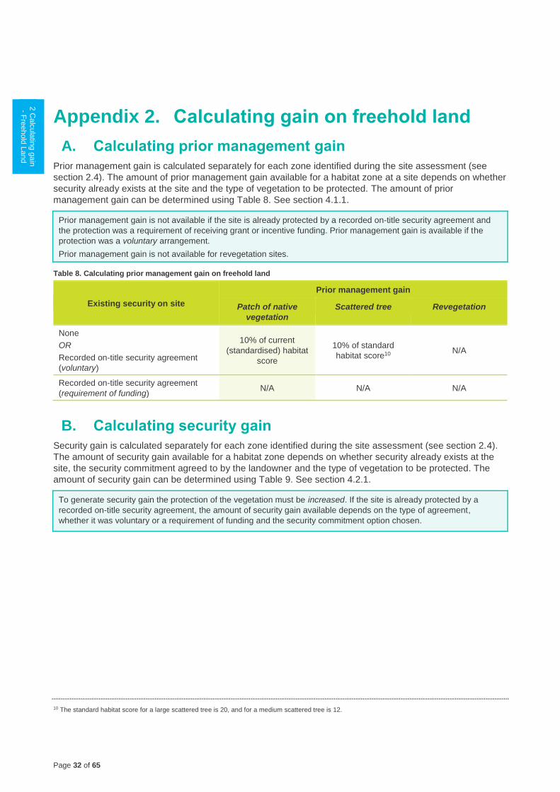
Page 32 of 65
1 G
ain
scorin
g
logic
2 C
alc
ula
ting g
ain
- Fre
ehold
Land
2.2
M a
nd I g
ain
in
woody v
egeta
tion
2.3
M a
nd I g
ain
in
HR
VP
or G
P
gra
ssla
nd
2.4
M a
nd I g
ain
in
oth
er g
rassla
nd
2.5
M a
nd I g
ain
in
non‑w
oody
wetla
nd
2.6
M a
nd I g
ain
for re
vegeta
tion
site
s
2.7
Ma
inte
nance
gain
for s
catte
red
tree s
ites
3 C
alc
ula
ting th
e
gain
score
- Cro
wn
Land
4 C
alc
ula
ting th
e
gain
score
Appendix 2. Calculating gain on freehold land
A. Calculating prior management gain
Prior management gain is calculated separately for each zone identified during the site assessment (see
section 2.4). The amount of prior management gain available for a habitat zone at a site depends on whether
security already exists at the site and the type of vegetation to be protected. The amount of prior
management gain can be determined using Table 8. See section 4.1.1.
Prior management gain is not available if the site is already protected by a recorded on-title security agreement and
the protection was a requirement of receiving grant or incentive funding. Prior management gain is available if the
protection was a voluntary arrangement.
Prior management gain is not available for revegetation sites.
Table 8. Calculating prior management gain on freehold land
Existing security on site
Prior management gain
Patch of native
vegetation
Scattered tree Revegetation
None
OR
Recorded on-title security agreement
(voluntary)
10% of current
(standardised) habitat
score
10% of standard
habitat score10 N/A
Recorded on-title security agreement
(requirement of funding) N/A N/A N/A
B. Calculating security gain
Security gain is calculated separately for each zone identified during the site assessment (see section 2.4).
The amount of security gain available for a habitat zone depends on whether security already exists at the
site, the security commitment agreed to by the landowner and the type of vegetation to be protected. The
amount of security gain can be determined using Table 9. See section 4.2.1.
To generate security gain the protection of the vegetation must be increased. If the site is already protected by a
recorded on-title security agreement, the amount of security gain available depends on the type of agreement,
whether it was voluntary or a requirement of funding and the security commitment option chosen.
10 The standard habitat score for a large scattered tree is 20, and for a medium scattered tree is 12.
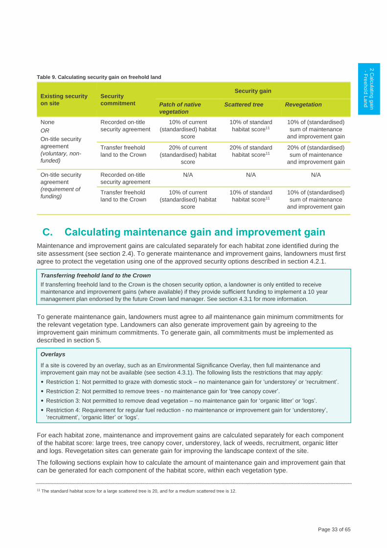
Page 33 of 65
1 G
ain
scorin
g
logic
2 C
alc
ula
ting g
ain
- Fre
ehold
Land
2.2
M a
nd I g
ain
in
woody v
egeta
tion
2.3
M a
nd I g
ain
in
HR
VP
or G
P
gra
ssla
nd
2.4
M a
nd I g
ain
in
oth
er g
rassla
nd
2.5
M a
nd I g
ain
in
non‑w
oody
wetla
nd
2.6
M a
nd I g
ain
for re
vegeta
tion
site
s
2.7
Ma
inte
nance
gain
for s
catte
red
tree s
ites
3 C
alc
ula
ting th
e
gain
score
- Cro
wn
Land
4 C
alc
ula
ting th
e
gain
score
Table 9. Calculating security gain on freehold land
Existing security
on site
Security
commitment
Security gain
Patch of native
vegetation
Scattered tree Revegetation
None
OR
On-title security
agreement
(voluntary, non-
funded)
Recorded on-title
security agreement
10% of current
(standardised) habitat
score
10% of standard
habitat score11
10% of (standardised)
sum of maintenance
and improvement gain
Transfer freehold
land to the Crown
20% of current
(standardised) habitat
score
20% of standard
habitat score11
20% of (standardised)
sum of maintenance
and improvement gain
On-title security
agreement
(requirement of
funding)
Recorded on-title
security agreement
N/A N/A N/A
Transfer freehold
land to the Crown
10% of current
(standardised) habitat
score
10% of standard
habitat score11
10% of (standardised)
sum of maintenance
and improvement gain
C. Calculating maintenance gain and improvement gain
Maintenance and improvement gains are calculated separately for each habitat zone identified during the
site assessment (see section 2.4). To generate maintenance and improvement gains, landowners must first
agree to protect the vegetation using one of the approved security options described in section 4.2.1.
Transferring freehold land to the Crown
If transferring freehold land to the Crown is the chosen security option, a landowner is only entitled to receive
maintenance and improvement gains (where available) if they provide sufficient funding to implement a 10 year
management plan endorsed by the future Crown land manager. See section 4.3.1 for more information.
To generate maintenance gain, landowners must agree to all maintenance gain minimum commitments for
the relevant vegetation type. Landowners can also generate improvement gain by agreeing to the
improvement gain minimum commitments. To generate gain, all commitments must be implemented as
described in section 5.
Overlays
If a site is covered by an overlay, such as an Environmental Significance Overlay, then full maintenance and
improvement gain may not be available (see section 4.3.1). The following lists the restrictions that may apply:
• Restriction 1: Not permitted to graze with domestic stock – no maintenance gain for ‘understorey’ or ‘recruitment’.
• Restriction 2: Not permitted to remove trees - no maintenance gain for ‘tree canopy cover’.
• Restriction 3: Not permitted to remove dead vegetation – no maintenance gain for ‘organic litter’ or ‘logs’.
• Restriction 4: Requirement for regular fuel reduction - no maintenance or improvement gain for ‘understorey’,
‘recruitment’, ‘organic litter’ or ‘logs’.
For each habitat zone, maintenance and improvement gains are calculated separately for each component
of the habitat score: large trees, tree canopy cover, understorey, lack of weeds, recruitment, organic litter
and logs. Revegetation sites can generate gain for improving the landscape context of the site.
The following sections explain how to calculate the amount of maintenance gain and improvement gain that
can be generated for each component of the habitat score, within each vegetation type.
11 The standard habitat score for a large scattered tree is 20, and for a medium scattered tree is 12.
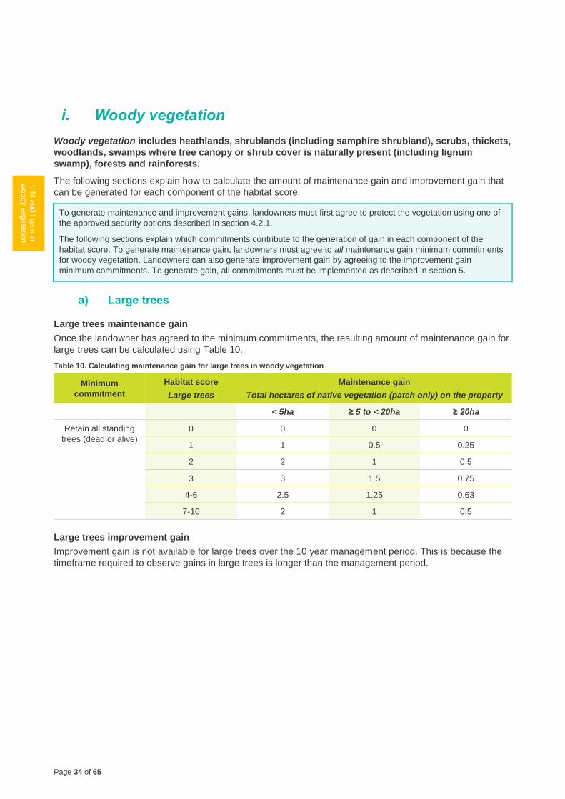
Page 34 of 65
1 G
ain
scorin
g
logic
2.1
Calc
ula
ting th
e
gain
score
- F
reehold
Land
i. M a
nd I g
ain
in
woody v
egeta
tion
2.3
M a
nd I g
ain
in
HR
VP
or G
P
gra
ssla
nd
2.4
M a
nd I g
ain
in
oth
er g
rassla
nd
2.5
M a
nd I g
ain
in
non‑w
oody
wetla
nd
2.6
M a
nd I g
ain
for re
vegeta
tion
site
s
2.7
Ma
inte
nance
gain
for s
catte
red
tree s
ites
3 C
alc
ula
ting th
e
gain
score
- Cro
wn
Land
4 C
alc
ula
ting th
e
gain
score
i. Woody vegetation
Woody vegetation includes heathlands, shrublands (including samphire shrubland), scrubs, thickets,
woodlands, swamps where tree canopy or shrub cover is naturally present (including lignum
swamp), forests and rainforests.
The following sections explain how to calculate the amount of maintenance gain and improvement gain that
can be generated for each component of the habitat score.
To generate maintenance and improvement gains, landowners must first agree to protect the vegetation using one of
the approved security options described in section 4.2.1.
The following sections explain which commitments contribute to the generation of gain in each component of the
habitat score. To generate maintenance gain, landowners must agree to all maintenance gain minimum commitments
for woody vegetation. Landowners can also generate improvement gain by agreeing to the improvement gain
minimum commitments. To generate gain, all commitments must be implemented as described in section 5.
a) Large trees
Large trees maintenance gain
Once the landowner has agreed to the minimum commitments, the resulting amount of maintenance gain for
large trees can be calculated using Table 10.
Table 10. Calculating maintenance gain for large trees in woody vegetation
Minimum
commitment
Habitat score
Large trees
Maintenance gain
Total hectares of native vegetation (patch only) on the property
< 5ha ≥ 5 to < 20ha ≥ 20ha
Retain all standing
trees (dead or alive)
0 0 0 0
1 1 0.5 0.25
2 2 1 0.5
3 3 1.5 0.75
4-6 2.5 1.25 0.63
7-10 2 1 0.5
Large trees improvement gain
Improvement gain is not available for large trees over the 10 year management period. This is because the
timeframe required to observe gains in large trees is longer than the management period.
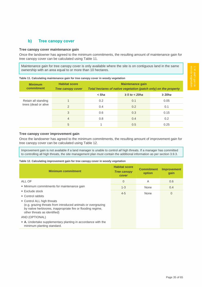
Page 35 of 65
1 G
ain
scorin
g
logic
2.1
Calc
ula
ting th
e
gain
score
-
Fre
ehold
Land
i. M a
nd I g
ain
in
woody v
egeta
tion
2.3
M a
nd I g
ain
in
HR
VP
or G
P
gra
ssla
nd
2.4
M a
nd I g
ain
in
oth
er g
rassla
nd
2.5
M a
nd I g
ain
in
non‑w
oody
wetla
nd
2.6
M a
nd I g
ain
for re
vegeta
tion
site
s
2.7
Ma
inte
nance
gain
for s
catte
red
tree s
ites
3 C
alc
ula
ting th
e
gain
score
- Cro
wn
Land
4 C
alc
ula
ting th
e
gain
score
b) Tree canopy cover
Tree canopy cover maintenance gain
Once the landowner has agreed to the minimum commitments, the resulting amount of maintenance gain for
tree canopy cover can be calculated using Table 11.
Maintenance gain for tree canopy cover is only available where the site is on contiguous land in the same ownership with an area equal to or more than 10 hectares.
Table 11. Calculating maintenance gain for tree canopy cover in woody vegetation
Minimum
commitment
Habitat score
Tree canopy cover
Maintenance gain
Total hectares of native vegetation (patch only) on the property
< 5ha ≥ 5 to < 20ha ≥ 20ha
Retain all standing
trees (dead or alive
1 0.2 0.1 0.05
2 0.4 0.2 0.1
3 0.6 0.3 0.15
4 0.8 0.4 0.2
5 1 0.5 0.25
Tree canopy cover improvement gain
Once the landowner has agreed to the minimum commitments, the resulting amount of improvement gain for
tree canopy cover can be calculated using Table 12.
Improvement gain is not available if a land manager is unable to control all high threats. If a manager has committed
to controlling all high threats, the site management plan must contain the additional information as per section 3.9.3.
Table 12. Calculating improvement gain for tree canopy cover in woody vegetation
Minimum commitment
Habitat score
Tree canopy
cover
Commitment
option
Improvement
gain
ALL OF
• Minimum commitments for maintenance gain
• Exclude stock
• Control rabbits
• Control ALL high threats
(e.g. grazing threats from introduced animals or overgrazing
by native herbivores, inappropriate fire or flooding regime,
other threats as identified)
AND (OPTIONAL)
• A. Undertake supplementary planting in accordance with the
minimum planting standard.
0 A 0.6
1-3 None 0.4
4-5 None 0

Page 36 of 65
1 G
ain
scorin
g
logic
2.1
Calc
ula
ting th
e
gain
score
- F
reehold
Land
i. M a
nd I g
ain
in
woody v
egeta
tion
2.3
M a
nd I g
ain
in
HR
VP
or G
P
gra
ssla
nd
2.4
M a
nd I g
ain
in
oth
er g
rassla
nd
2.5
M a
nd I g
ain
in
non‑w
oody
wetla
nd
2.6
M a
nd I g
ain
for re
vegeta
tion
site
s
2.7
Ma
inte
nance
gain
for s
catte
red
tree s
ites
3 C
alc
ula
ting th
e
gain
score
- Cro
wn
Land
4 C
alc
ula
ting th
e
gain
score
c) Understorey
Understorey maintenance gain
Once the landowner has agreed to the minimum commitments, the resulting amount of maintenance gain for
understorey can be calculated using Table 13.
Table 13. Calculating maintenance gain for understorey in woody vegetation
Minimum commitment Habitat score
Understorey Maintenance gain
ALL OF
• Exclude stock
• Ensure that weed cover does not
increase beyond the current level
• Monitor for any new and emerging
high threat weeds and eliminate to
< 1% cover.
0 0
5 0.5
10 1
15 1.5
20 2
25 2.5
Understorey improvement gain
Once the landowner has agreed to the minimum commitments, the resulting amount of improvement gain for
understorey can be calculated using Table 14.
Improvement gain is not available if a land manager is unable to control all high threats. If a manager has committed
to controlling all high threats, the site management plan must contain the additional information as per section 3.9.3.
Table 14. Calculating improvement gain for understorey in woody vegetation
Minimum commitments
Habitat score Commitment
option
Improvement
gain Understorey Lack of
weeds
ALL OF
• Minimum commitments for maintenance gain
• Control rabbits
• Control ALL high threats
(e.g. grazing threats from introduced animals or
overgrazing by native herbivores, inappropriate
fire or flooding regime, other threats as identified)
AND EITHER
• A. Eliminate all woody weeds AND all high threat
herbaceous and grassy weeds to < 1% cover12,
or
• B. Eliminate all woody weeds to < 1% cover
AND (OPTIONAL)
• C. Undertake supplementary planting in
accordance with the minimum planting standard.
0-5 < 9 B 1.25
9-15 A 2.5
B 1.25
A AND C 3.5
B AND C 2.25
10-20 < 9 B 2.5
9-15 A 5
B 2.5
25 0-15 N/A 0
12 Not considered feasible if the current ‘Lack of weeds’ score is <9
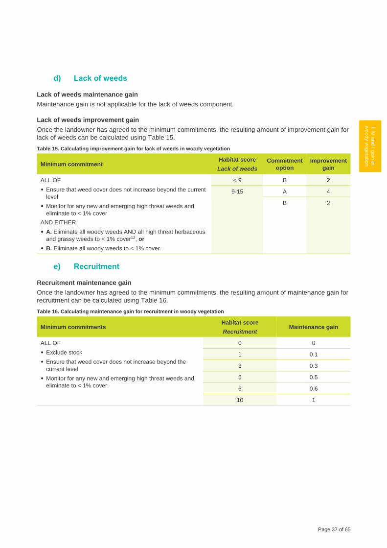
Page 37 of 65
1 G
ain
scorin
g
logic
2.1
Calc
ula
ting th
e
gain
score
-
Fre
ehold
Land
i. M a
nd I g
ain
in
woody v
egeta
tion
2.3
M a
nd I g
ain
in
HR
VP
or G
P
gra
ssla
nd
2.4
M a
nd I g
ain
in
oth
er g
rassla
nd
2.5
M a
nd I g
ain
in
non‑w
oody
wetla
nd
2.6
M a
nd I g
ain
for re
vegeta
tion
site
s
2.7
Ma
inte
nance
gain
for s
catte
red
tree s
ites
3 C
alc
ula
ting th
e
gain
score
- Cro
wn
Land
4 C
alc
ula
ting th
e
gain
score
d) Lack of weeds
Lack of weeds maintenance gain
Maintenance gain is not applicable for the lack of weeds component.
Lack of weeds improvement gain
Once the landowner has agreed to the minimum commitments, the resulting amount of improvement gain for
lack of weeds can be calculated using Table 15.
Table 15. Calculating improvement gain for lack of weeds in woody vegetation
Minimum commitment Habitat score
Lack of weeds
Commitment
option
Improvement
gain
ALL OF
• Ensure that weed cover does not increase beyond the current
level
• Monitor for any new and emerging high threat weeds and
eliminate to < 1% cover
AND EITHER
• A. Eliminate all woody weeds AND all high threat herbaceous
and grassy weeds to < 1% cover12, or
• B. Eliminate all woody weeds to < 1% cover.
< 9 B 2
9-15 A 4
B 2
e) Recruitment
Recruitment maintenance gain
Once the landowner has agreed to the minimum commitments, the resulting amount of maintenance gain for
recruitment can be calculated using Table 16.
Table 16. Calculating maintenance gain for recruitment in woody vegetation
Minimum commitments Habitat score
Recruitment Maintenance gain
ALL OF
• Exclude stock
• Ensure that weed cover does not increase beyond the
current level
• Monitor for any new and emerging high threat weeds and
eliminate to < 1% cover.
0 0
1 0.1
3 0.3
5 0.5
6 0.6
10 1
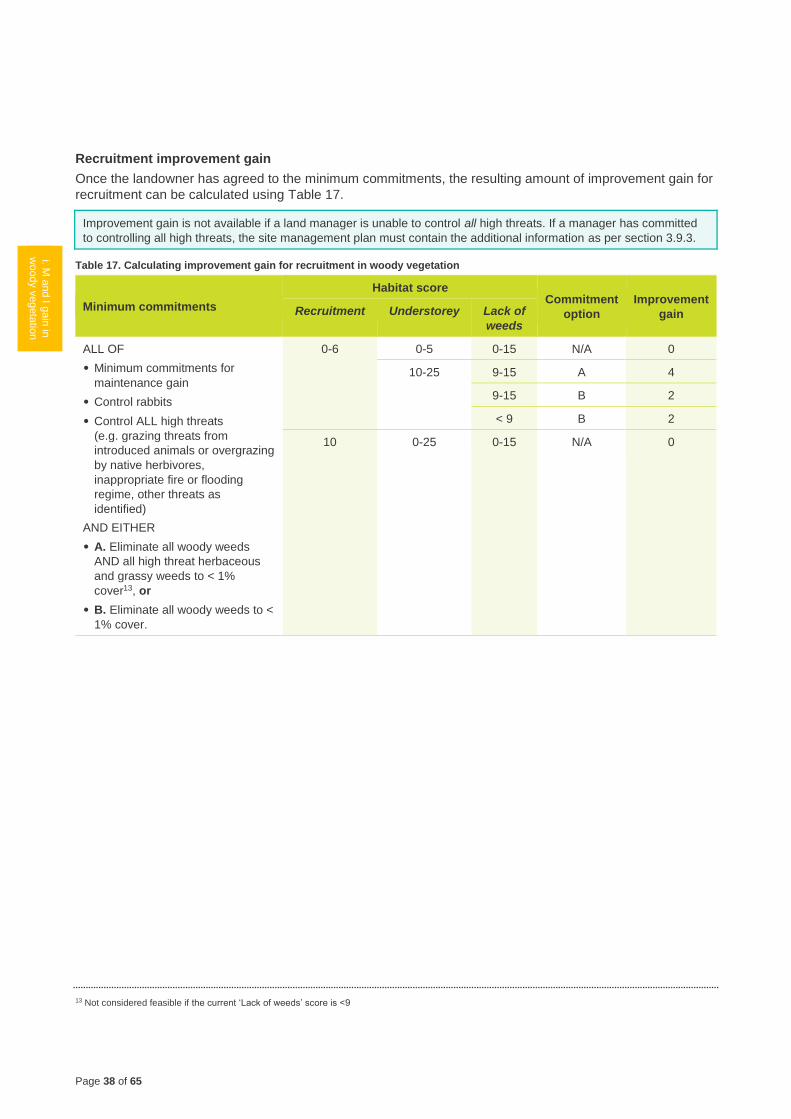
Page 38 of 65
1 G
ain
scorin
g
logic
2.1
Calc
ula
ting th
e
gain
score
- F
reehold
Land
i. M a
nd I g
ain
in
woody v
egeta
tion
2.3
M a
nd I g
ain
in
HR
VP
or G
P
gra
ssla
nd
2.4
M a
nd I g
ain
in
oth
er g
rassla
nd
2.5
M a
nd I g
ain
in
non‑w
oody
wetla
nd
2.6
M a
nd I g
ain
for re
vegeta
tion
site
s
2.7
Ma
inte
nance
gain
for s
catte
red
tree s
ites
3 C
alc
ula
ting th
e
gain
score
- Cro
wn
Land
4 C
alc
ula
ting th
e
gain
score
Recruitment improvement gain
Once the landowner has agreed to the minimum commitments, the resulting amount of improvement gain for
recruitment can be calculated using Table 17.
Improvement gain is not available if a land manager is unable to control all high threats. If a manager has committed
to controlling all high threats, the site management plan must contain the additional information as per section 3.9.3.
Table 17. Calculating improvement gain for recruitment in woody vegetation
Minimum commitments
Habitat score Commitment
option
Improvement
gain Recruitment Understorey Lack of
weeds
ALL OF
• Minimum commitments for
maintenance gain
• Control rabbits
• Control ALL high threats
(e.g. grazing threats from
introduced animals or overgrazing
by native herbivores,
inappropriate fire or flooding
regime, other threats as
identified)
AND EITHER
• A. Eliminate all woody weeds
AND all high threat herbaceous
and grassy weeds to < 1%
cover13, or
• B. Eliminate all woody weeds to <
1% cover.
0-6 0-5 0-15 N/A 0
10-25 9-15 A 4
9-15 B 2
< 9 B 2
10 0-25 0-15 N/A 0
13 Not considered feasible if the current ‘Lack of weeds’ score is <9
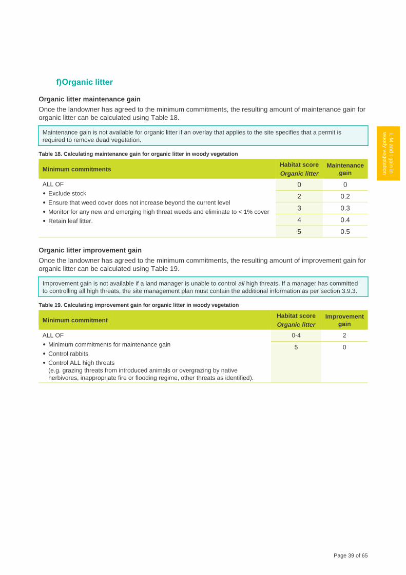
Page 39 of 65
1 G
ain
scorin
g
logic
2.1
Calc
ula
ting th
e
gain
score
-
Fre
ehold
Land
i. M a
nd I g
ain
in
woody v
egeta
tion
2.3
M a
nd I g
ain
in
HR
VP
or G
P
gra
ssla
nd
2.4
M a
nd I g
ain
in
oth
er g
rassla
nd
2.5
M a
nd I g
ain
in
non‑w
oody
wetla
nd
2.6
M a
nd I g
ain
for re
vegeta
tion
site
s
2.7
Ma
inte
nance
gain
for s
catte
red
tree s
ites
3 C
alc
ula
ting th
e
gain
score
- Cro
wn
Land
4 C
alc
ula
ting th
e
gain
score
f) Organic litter
Organic litter maintenance gain
Once the landowner has agreed to the minimum commitments, the resulting amount of maintenance gain for
organic litter can be calculated using Table 18.
Maintenance gain is not available for organic litter if an overlay that applies to the site specifies that a permit is
required to remove dead vegetation.
Table 18. Calculating maintenance gain for organic litter in woody vegetation
Minimum commitments Habitat score
Organic litter
Maintenance
gain
ALL OF
• Exclude stock
• Ensure that weed cover does not increase beyond the current level
• Monitor for any new and emerging high threat weeds and eliminate to < 1% cover
• Retain leaf litter.
0 0
2 0.2
3 0.3
4 0.4
5 0.5
Organic litter improvement gain
Once the landowner has agreed to the minimum commitments, the resulting amount of improvement gain for
organic litter can be calculated using Table 19.
Improvement gain is not available if a land manager is unable to control all high threats. If a manager has committed
to controlling all high threats, the site management plan must contain the additional information as per section 3.9.3.
Table 19. Calculating improvement gain for organic litter in woody vegetation
Minimum commitment Habitat score
Organic litter
Improvement
gain
ALL OF
• Minimum commitments for maintenance gain
• Control rabbits
• Control ALL high threats
(e.g. grazing threats from introduced animals or overgrazing by native
herbivores, inappropriate fire or flooding regime, other threats as identified).
0-4 2
5 0
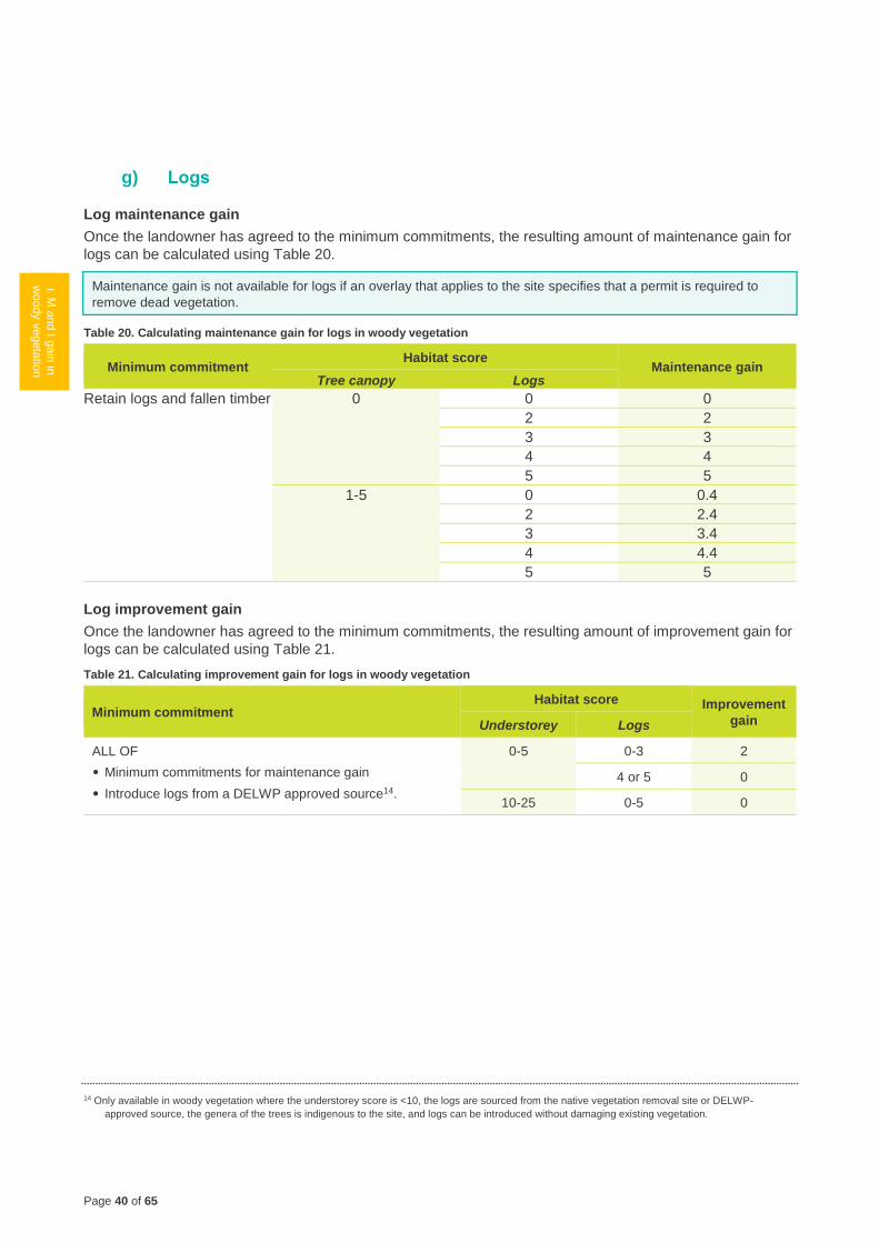
Page 40 of 65
1 G
ain
scorin
g
logic
2.1
Calc
ula
ting th
e
gain
score
- F
reehold
Land
i. M a
nd I g
ain
in
woody v
egeta
tion
2.3
M a
nd I g
ain
in
HR
VP
or G
P
gra
ssla
nd
2.4
M a
nd I g
ain
in
oth
er g
rassla
nd
2.5
M a
nd I g
ain
in
non‑w
oody
wetla
nd
2.6
M a
nd I g
ain
for re
vegeta
tion
site
s
2.7
Ma
inte
nance
gain
for s
catte
red
tree s
ites
3 C
alc
ula
ting th
e
gain
score
- Cro
wn
Land
4 C
alc
ula
ting th
e
gain
score
g) Logs
Log maintenance gain
Once the landowner has agreed to the minimum commitments, the resulting amount of maintenance gain for
logs can be calculated using Table 20.
Maintenance gain is not available for logs if an overlay that applies to the site specifies that a permit is required to
remove dead vegetation.
Table 20. Calculating maintenance gain for logs in woody vegetation
Minimum commitment Habitat score
Maintenance gain Tree canopy Logs
Retain logs and fallen timber 0 0 0
2 2
3 3
4 4
5 5
1-5 0 0.4
2 2.4
3 3.4
4 4.4
5 5
Log improvement gain
Once the landowner has agreed to the minimum commitments, the resulting amount of improvement gain for
logs can be calculated using Table 21.
Table 21. Calculating improvement gain for logs in woody vegetation
Minimum commitment Habitat score Improvement
gain Understorey Logs
ALL OF
• Minimum commitments for maintenance gain
• Introduce logs from a DELWP approved source14.
0-5 0-3 2
4 or 5 0
10-25 0-5 0
14 Only available in woody vegetation where the understorey score is <10, the logs are sourced from the native vegetation removal site or DELWP-
approved source, the genera of the trees is indigenous to the site, and logs can be introduced without damaging existing vegetation.
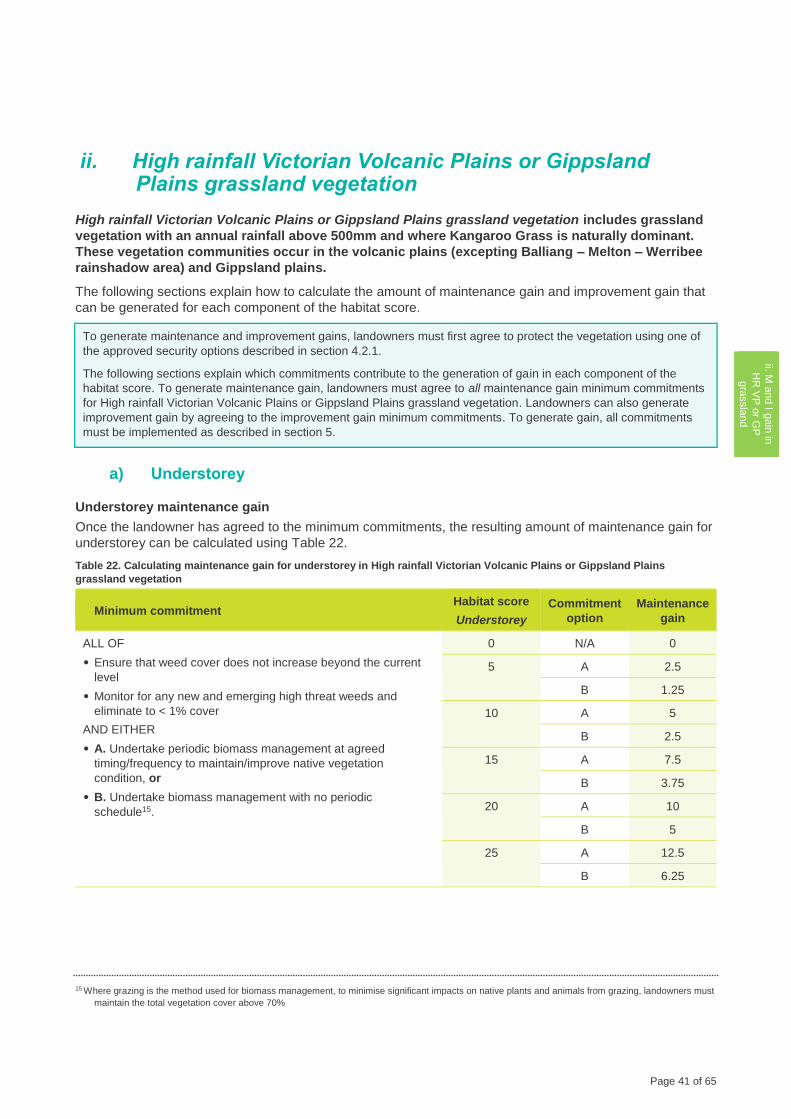
Page 41 of 65
1 G
ain
scorin
g
logic
2.1
Calc
ula
ting th
e
gain
score
-
Fre
ehold
Land
2.2
M a
nd I g
ain
in
woody v
egeta
tion
ii. M a
nd I g
ain
in
HR
VP
or G
P
gra
ssla
nd
2.4
M a
nd I g
ain
in
oth
er g
rassla
nd
2.5
M a
nd I g
ain
in
non‑w
oody
wetla
nd
2.6
M a
nd I g
ain
for re
vegeta
tion
site
s
2.7
Ma
inte
nance
gain
for s
catte
red
tree s
ites
3 C
alc
ula
ting th
e
gain
score
- Cro
wn
Land
4 C
alc
ula
ting th
e
gain
score
ii. High rainfall Victorian Volcanic Plains or Gippsland Plains grassland vegetation
High rainfall Victorian Volcanic Plains or Gippsland Plains grassland vegetation includes grassland
vegetation with an annual rainfall above 500mm and where Kangaroo Grass is naturally dominant.
These vegetation communities occur in the volcanic plains (excepting Balliang – Melton – Werribee
rainshadow area) and Gippsland plains.
The following sections explain how to calculate the amount of maintenance gain and improvement gain that
can be generated for each component of the habitat score.
To generate maintenance and improvement gains, landowners must first agree to protect the vegetation using one of
the approved security options described in section 4.2.1.
The following sections explain which commitments contribute to the generation of gain in each component of the
habitat score. To generate maintenance gain, landowners must agree to all maintenance gain minimum commitments
for High rainfall Victorian Volcanic Plains or Gippsland Plains grassland vegetation. Landowners can also generate
improvement gain by agreeing to the improvement gain minimum commitments. To generate gain, all commitments
must be implemented as described in section 5.
a) Understorey
Understorey maintenance gain
Once the landowner has agreed to the minimum commitments, the resulting amount of maintenance gain for
understorey can be calculated using Table 22.
Table 22. Calculating maintenance gain for understorey in High rainfall Victorian Volcanic Plains or Gippsland Plains
grassland vegetation
Minimum commitment Habitat score
Understorey
Commitment
option
Maintenance
gain
ALL OF
• Ensure that weed cover does not increase beyond the current
level
• Monitor for any new and emerging high threat weeds and
eliminate to < 1% cover
AND EITHER
• A. Undertake periodic biomass management at agreed
timing/frequency to maintain/improve native vegetation
condition, or
• B. Undertake biomass management with no periodic
schedule15.
0 N/A 0
5 A 2.5
B 1.25
10 A 5
B 2.5
15 A 7.5
B 3.75
20 A 10
B 5
25 A 12.5
B 6.25
15 Where grazing is the method used for biomass management, to minimise significant impacts on native plants and animals from grazing, landowners must
maintain the total vegetation cover above 70%
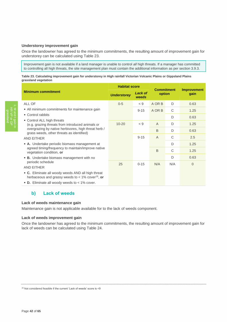
Page 42 of 65
1 G
ain
scorin
g
logic
2.1
Calc
ula
ting th
e
gain
score
- F
reehold
Land
2.2
M a
nd I g
ain
in
woody v
egeta
tion
ii. M a
nd I g
ain
in
HR
VP
or G
P
gra
ssla
nd
2.4
M a
nd I g
ain
in
oth
er g
rassla
nd
2.5
M a
nd I g
ain
in
non‑w
oody
wetla
nd
2.6
M a
nd I g
ain
for re
vegeta
tion
site
s
2.7
Ma
inte
nance
gain
for s
catte
red
tre
e s
ites
3 C
alc
ula
ting th
e
gain
score
- Cro
wn
Land
4 C
alc
ula
ting th
e
gain
score
Understorey improvement gain
Once the landowner has agreed to the minimum commitments, the resulting amount of improvement gain for
understorey can be calculated using Table 23.
Improvement gain is not available if a land manager is unable to control all high threats. If a manager has committed
to controlling all high threats, the site management plan must contain the additional information as per section 3.9.3.
Table 23. Calculating improvement gain for understorey in High rainfall Victorian Volcanic Plains or Gippsland Plains
grassland vegetation
Minimum commitment
Habitat score Commitment
option Improvement
gain Understorey Lack of weeds
ALL OF
• All minimum commitments for maintenance gain
• Control rabbits
• Control ALL high threats
(e.g. grazing threats from introduced animals or
overgrazing by native herbivores, high threat herb /
grass weeds, other threats as identified)
AND EITHER
• A. Undertake periodic biomass management at
agreed timing/frequency to maintain/improve native
vegetation condition, or
• B. Undertake biomass management with no
periodic schedule
AND EITHER
• C. Eliminate all woody weeds AND all high threat
herbaceous and grassy weeds to < 1% cover16, or
• D. Eliminate all woody weeds to < 1% cover.
0-5 < 9 A OR B D 0.63
9-15 A OR B C 1.25
D 0.63
10-20 < 9 A D 1.25
B D 0.63
9-15 A C 2.5
D 1.25
B C 1.25
D 0.63
25 0-15 N/A N/A 0
b) Lack of weeds
Lack of weeds maintenance gain
Maintenance gain is not applicable available for to the lack of weeds component.
Lack of weeds improvement gain
Once the landowner has agreed to the minimum commitments, the resulting amount of improvement gain for
lack of weeds can be calculated using Table 24.
16 Not considered feasible if the current ‘Lack of weeds’ score is <9
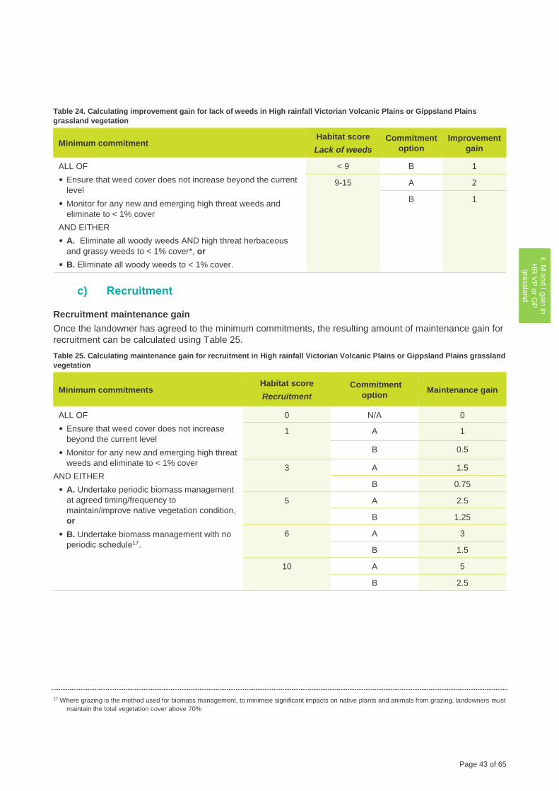
Page 43 of 65
1 G
ain
scorin
g
logic
2.1
Calc
ula
ting th
e
gain
score
-
Fre
ehold
Land
2.2
M a
nd I g
ain
in
woody v
egeta
tion
ii. M a
nd I g
ain
in
HR
VP
or G
P
gra
ssla
nd
2.4
M a
nd I g
ain
in
oth
er g
rassla
nd
2.5
M a
nd I g
ain
in
non‑w
oody
wetla
nd
2.6
M a
nd I g
ain
for re
vegeta
tion
site
s
2.7
Ma
inte
nance
gain
for s
catte
red
tree s
ites
3 C
alc
ula
ting th
e
gain
score
- Cro
wn
Land
4 C
alc
ula
ting th
e
gain
score
Table 24. Calculating improvement gain for lack of weeds in High rainfall Victorian Volcanic Plains or Gippsland Plains
grassland vegetation
Minimum commitment Habitat score
Lack of weeds
Commitment
option
Improvement
gain
ALL OF
• Ensure that weed cover does not increase beyond the current
level
• Monitor for any new and emerging high threat weeds and
eliminate to < 1% cover
AND EITHER
• A. Eliminate all woody weeds AND high threat herbaceous
and grassy weeds to < 1% cover*, or
• B. Eliminate all woody weeds to < 1% cover.
< 9 B 1
9-15 A 2
B 1
c) Recruitment
Recruitment maintenance gain
Once the landowner has agreed to the minimum commitments, the resulting amount of maintenance gain for
recruitment can be calculated using Table 25.
Table 25. Calculating maintenance gain for recruitment in High rainfall Victorian Volcanic Plains or Gippsland Plains grassland
vegetation
Minimum commitments Habitat score
Recruitment
Commitment
option Maintenance gain
ALL OF
• Ensure that weed cover does not increase
beyond the current level
• Monitor for any new and emerging high threat
weeds and eliminate to < 1% cover
AND EITHER
• A. Undertake periodic biomass management
at agreed timing/frequency to
maintain/improve native vegetation condition,
or
• B. Undertake biomass management with no
periodic schedule17.
0 N/A 0
1 A 1
B 0.5
3 A 1.5
B 0.75
5 A 2.5
B 1.25
6 A 3
B 1.5
10 A 5
B 2.5
17 Where grazing is the method used for biomass management, to minimise significant impacts on native plants and animals from grazing, landowners must
maintain the total vegetation cover above 70%
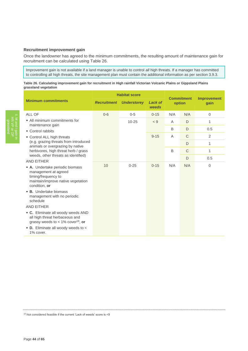
Page 44 of 65
1 G
ain
scorin
g
logic
2.1
Calc
ula
ting th
e
gain
score
- F
reehold
Land
2.2
M a
nd I g
ain
in
woody v
egeta
tion
ii. M a
nd I g
ain
in
HR
VP
or G
P
gra
ssla
nd
2.4
M a
nd I g
ain
in
oth
er g
rassla
nd
2.5
M a
nd I g
ain
in
non‑w
oody
wetla
nd
2.6
M a
nd I g
ain
for re
vegeta
tion
site
s
2.7
Ma
inte
nance
gain
for s
catte
red
tre
e s
ites
3 C
alc
ula
ting th
e
gain
score
- Cro
wn
Land
4 C
alc
ula
ting th
e
gain
score
Recruitment improvement gain
Once the landowner has agreed to the minimum commitments, the resulting amount of maintenance gain for
recruitment can be calculated using Table 26.
Improvement gain is not available if a land manager is unable to control all high threats. If a manager has committed
to controlling all high threats, the site management plan must contain the additional information as per section 3.9.3.
Table 26. Calculating improvement gain for recruitment in High rainfall Victorian Volcanic Plains or Gippsland Plains
grassland vegetation
Minimum commitments
Habitat score Commitment
option
Improvement
gain Recruitment Understorey Lack of
weeds
ALL OF
• All minimum commitments for
maintenance gain
• Control rabbits
• Control ALL high threats
(e.g. grazing threats from introduced
animals or overgrazing by native
herbivores, high threat herb / grass
weeds, other threats as identified)
AND EITHER
• A. Undertake periodic biomass
management at agreed
timing/frequency to
maintain/improve native vegetation
condition, or
• B. Undertake biomass
management with no periodic
schedule
AND EITHER
• C. Eliminate all woody weeds AND
all high threat herbaceous and
grassy weeds to < 1% cover18, or
• D. Eliminate all woody weeds to <
1% cover.
0-6 0-5 0-15 N/A N/A 0
10-25 < 9 A D 1
B D 0.5
9-15 A C 2
D 1
B C 1
D 0.5
10 0-25 0-15 N/A N/A 0
18 Not considered feasible if the current ‘Lack of weeds’ score is <9
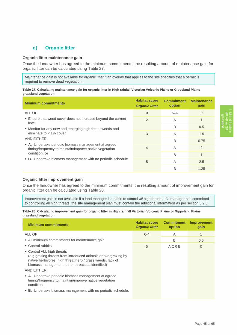
Page 45 of 65
1 G
ain
scorin
g
logic
2.1
Calc
ula
ting th
e
gain
score
-
Fre
ehold
Land
2.2
M a
nd I g
ain
in
woody v
egeta
tion
ii. M a
nd I g
ain
in
HR
VP
or G
P
gra
ssla
nd
2.4
M a
nd I g
ain
in
oth
er g
rassla
nd
2.5
M a
nd I g
ain
in
non‑w
oody
wetla
nd
2.6
M a
nd I g
ain
for re
vegeta
tion
site
s
2.7
Ma
inte
nance
gain
for s
catte
red
tree s
ites
3 C
alc
ula
ting th
e
gain
score
- Cro
wn
Land
4 C
alc
ula
ting th
e
gain
score
d) Organic litter
Organic litter maintenance gain
Once the landowner has agreed to the minimum commitments, the resulting amount of maintenance gain for
organic litter can be calculated using Table 27.
Maintenance gain is not available for organic litter if an overlay that applies to the site specifies that a permit is
required to remove dead vegetation.
Table 27. Calculating maintenance gain for organic litter in High rainfall Victorian Volcanic Plains or Gippsland Plains
grassland vegetation
Minimum commitments Habitat score
Organic litter
Commitment
option
Maintenance
gain
ALL OF
• Ensure that weed cover does not increase beyond the current
level
• Monitor for any new and emerging high threat weeds and
eliminate to < 1% cover
AND EITHER
• A. Undertake periodic biomass management at agreed
timing/frequency to maintain/improve native vegetation
condition, or
• B. Undertake biomass management with no periodic schedule.
0 N/A 0
2 A 1
B 0.5
3 A 1.5
B 0.75
4 A 2
B 1
5 A 2.5
B 1.25
Organic litter improvement gain
Once the landowner has agreed to the minimum commitments, the resulting amount of improvement gain for
organic litter can be calculated using Table 28.
Improvement gain is not available if a land manager is unable to control all high threats. If a manager has committed
to controlling all high threats, the site management plan must contain the additional information as per section 3.9.3.
Table 28. Calculating improvement gain for organic litter in High rainfall Victorian Volcanic Plains or Gippsland Plains
grassland vegetation
Minimum commitments Habitat score
Organic litter
Commitment
option
Improvement
gain
ALL OF
• All minimum commitments for maintenance gain
• Control rabbits
• Control ALL high threats
(e.g grazing threats from introduced animals or overgrazing by
native herbivores, high threat herb / grass weeds, lack of
biomass management, other threats as identified)
AND EITHER
• A. Undertake periodic biomass management at agreed
timing/frequency to maintain/improve native vegetation
condition
• B. Undertake biomass management with no periodic schedule.
0-4 A 1
B 0.5
5 A OR B 0
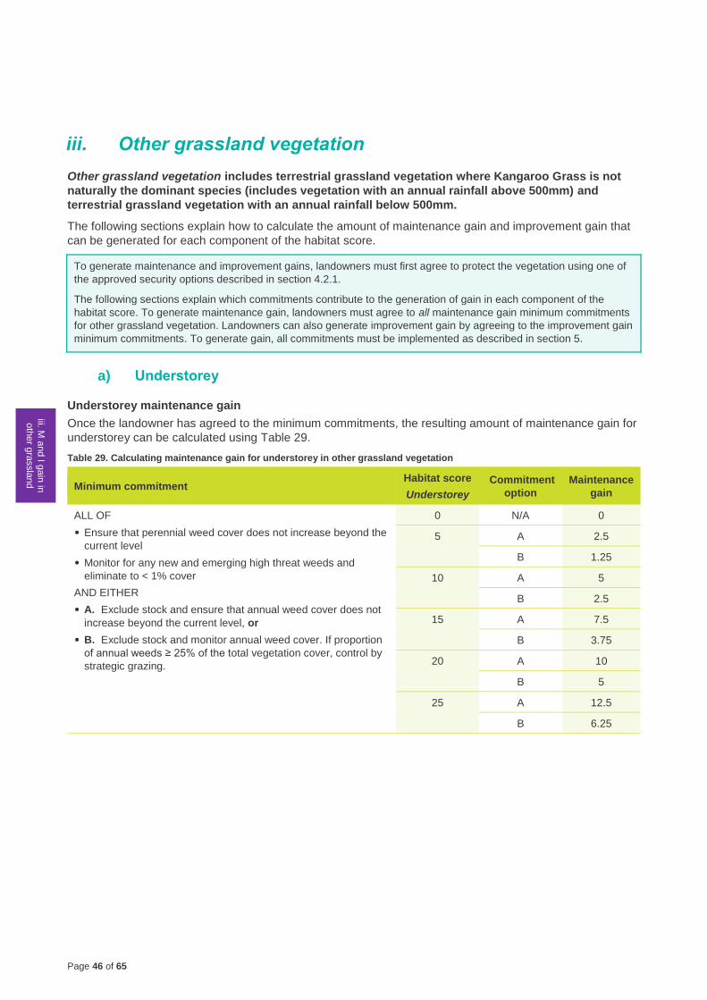
Page 46 of 65
1 G
ain
scorin
g
logic
2.1
Calc
ula
ting th
e
gain
score
- F
reehold
Land
2.2
M a
nd I g
ain
in
woody v
egeta
tion
2.3
M a
nd I g
ain
in
HR
VP
or G
P
gra
ssla
nd
iii. M a
nd I g
ain
in
oth
er g
rassla
nd
2.5
M a
nd I g
ain
in
non‑w
oody
wetla
nd
2.6
M a
nd I g
ain
for re
vegeta
tion
site
s
2.7
Ma
inte
nance
gain
for s
catte
red
tree s
ites
3 C
alc
ula
ting th
e
gain
score
- Cro
wn
Land
4 C
alc
ula
ting th
e
gain
score
iii. Other grassland vegetation
Other grassland vegetation includes terrestrial grassland vegetation where Kangaroo Grass is not
naturally the dominant species (includes vegetation with an annual rainfall above 500mm) and
terrestrial grassland vegetation with an annual rainfall below 500mm.
The following sections explain how to calculate the amount of maintenance gain and improvement gain that
can be generated for each component of the habitat score.
To generate maintenance and improvement gains, landowners must first agree to protect the vegetation using one of
the approved security options described in section 4.2.1.
The following sections explain which commitments contribute to the generation of gain in each component of the
habitat score. To generate maintenance gain, landowners must agree to all maintenance gain minimum commitments
for other grassland vegetation. Landowners can also generate improvement gain by agreeing to the improvement gain
minimum commitments. To generate gain, all commitments must be implemented as described in section 5.
a) Understorey
Understorey maintenance gain
Once the landowner has agreed to the minimum commitments, the resulting amount of maintenance gain for
understorey can be calculated using Table 29.
Table 29. Calculating maintenance gain for understorey in other grassland vegetation
Minimum commitment Habitat score
Understorey
Commitment
option
Maintenance
gain
ALL OF
• Ensure that perennial weed cover does not increase beyond the
current level
• Monitor for any new and emerging high threat weeds and
eliminate to < 1% cover
AND EITHER
• A. Exclude stock and ensure that annual weed cover does not
increase beyond the current level, or
• B. Exclude stock and monitor annual weed cover. If proportion
of annual weeds ≥ 25% of the total vegetation cover, control by
strategic grazing.
0 N/A 0
5 A 2.5
B 1.25
10 A 5
B 2.5
15 A 7.5
B 3.75
20 A 10
B 5
25 A 12.5
B 6.25
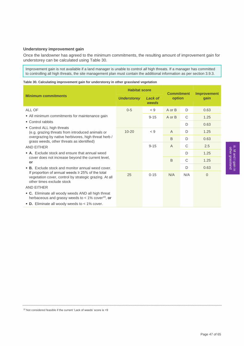
Page 47 of 65
1 G
ain
scorin
g
logic
2.1
Calc
ula
ting th
e
gain
score
-
Fre
ehold
Land
2.2
M a
nd I g
ain
in
woody v
egeta
tion
2.3
M a
nd I g
ain
in
HR
VP
or G
P
gra
ssla
nd
iii. M a
nd I g
ain
in
oth
er g
rassla
nd
2.5
M a
nd I g
ain
in
non‑w
oody
wetla
nd
2.6
M a
nd I g
ain
fo
r revegeta
tion
site
s
2.7
Ma
inte
nance
gain
for s
catte
red
tree s
ites
3 C
alc
ula
ting th
e
gain
score
- Cro
wn
Land
4 C
alc
ula
ting th
e
gain
score
Understorey improvement gain
Once the landowner has agreed to the minimum commitments, the resulting amount of improvement gain for
understorey can be calculated using Table 30.
Improvement gain is not available if a land manager is unable to control all high threats. If a manager has committed
to controlling all high threats, the site management plan must contain the additional information as per section 3.9.3.
Table 30. Calculating improvement gain for understorey in other grassland vegetation
Minimum commitments
Habitat score Commitment
option
Improvement
gain Understorey Lack of
weeds
ALL OF
• All minimum commitments for maintenance gain
• Control rabbits
• Control ALL high threats
(e.g. grazing threats from introduced animals or
overgrazing by native herbivores, high threat herb /
grass weeds, other threats as identified)
AND EITHER
• A. Exclude stock and ensure that annual weed
cover does not increase beyond the current level,
or
• B. Exclude stock and monitor annual weed cover.
If proportion of annual weeds ≥ 25% of the total
vegetation cover, control by strategic grazing. At all
other times exclude stock
AND EITHER
• C. Eliminate all woody weeds AND all high threat
herbaceous and grassy weeds to < 1% cover19, or
• D. Eliminate all woody weeds to < 1% cover.
0-5 < 9 A or B D 0.63
9-15 A or B C 1.25
D 0.63
10-20 < 9 A D 1.25
B D 0.63
9-15 A C 2.5
D 1.25
B C 1.25
D 0.63
25 0-15 N/A N/A 0
19 Not considered feasible if the current ‘Lack of weeds’ score is <9
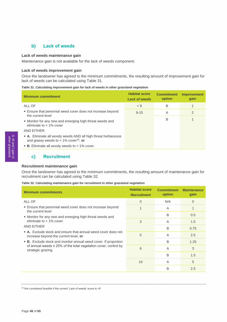
Page 48 of 65
1 G
ain
scorin
g
logic
2.1
Calc
ula
ting th
e
gain
score
- F
reehold
Land
2.2
M a
nd I g
ain
in
woody v
egeta
tion
2.3
M a
nd I g
ain
in
HR
VP
or G
P
gra
ssla
nd
iii. M a
nd I g
ain
in
oth
er g
rassla
nd
2.5
M a
nd I g
ain
in
non‑w
oody
wetla
nd
2.6
M a
nd I g
ain
for re
vegeta
tion
site
s
2.7
Ma
inte
nance
gain
for s
catte
red
tree s
ites
3 C
alc
ula
ting th
e
gain
score
- Cro
wn
Land
4 C
alc
ula
ting th
e
gain
score
b) Lack of weeds
Lack of weeds maintenance gain
Maintenance gain is not available for the lack of weeds component.
Lack of weeds improvement gain
Once the landowner has agreed to the minimum commitments, the resulting amount of improvement gain for
lack of weeds can be calculated using Table 31.
Table 31. Calculating improvement gain for lack of weeds in other grassland vegetation
Minimum commitment Habitat score
Lack of weeds
Commitment
option
Improvement
gain
ALL OF
• Ensure that perennial weed cover does not increase beyond
the current level
• Monitor for any new and emerging high threat weeds and
eliminate to < 1% cover
AND EITHER
• A. Eliminate all woody weeds AND all high threat herbaceous
and grassy weeds to < 1% cover20, or
• B. Eliminate all woody weeds to < 1% cover.
< 9 B 1
9-15 A 2
B 1
c) Recruitment
Recruitment maintenance gain
Once the landowner has agreed to the minimum commitments, the resulting amount of maintenance gain for
recruitment can be calculated using Table 32.
Table 32. Calculating maintenance gain for recruitment in other grassland vegetation
Minimum commitments Habitat score
Recruitment
Commitment
option
Maintenance
gain
ALL OF
• Ensure that perennial weed cover does not increase beyond
the current level
• Monitor for any new and emerging high threat weeds and
eliminate to < 1% cover
AND EITHER
• A. Exclude stock and ensure that annual weed cover does not
increase beyond the current level, or
• B. Exclude stock and monitor annual weed cover. If proportion
of annual weeds ≥ 25% of the total vegetation cover, control by
strategic grazing.
0 N/A 0
1 A 1
B 0.5
3 A 1.5
B 0.75
5 A 2.5
B 1.25
6 A 3
B 1.5
10 A 5
B 2.5
20 Not considered feasible if the current ‘Lack of weeds’ score is <9
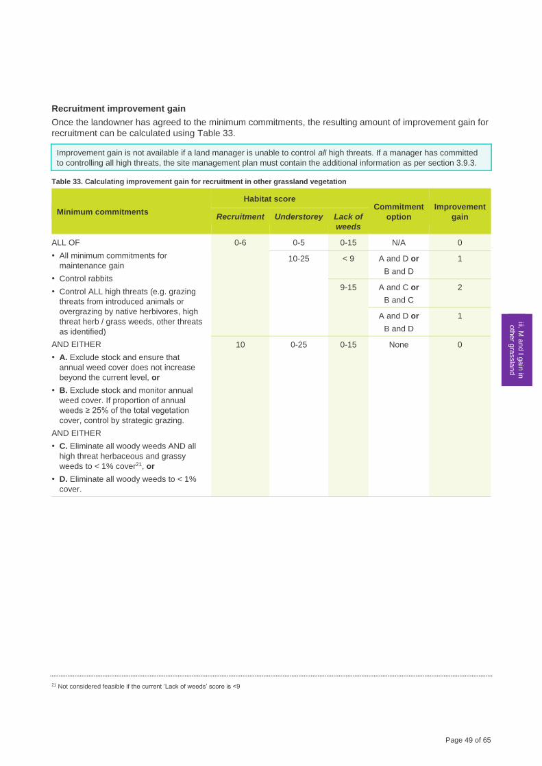
Page 49 of 65
1 G
ain
scorin
g
logic
2.1
Calc
ula
ting th
e
gain
score
-
Fre
ehold
Land
2.2
M a
nd I g
ain
in
woody v
egeta
tion
2.3
M a
nd I g
ain
in
HR
VP
or G
P
gra
ssla
nd
iii. M a
nd I g
ain
in
oth
er g
rassla
nd
2.5
M a
nd I g
ain
in
non‑w
oody
wetla
nd
2.6
M a
nd I g
ain
fo
r revegeta
tion
site
s
2.7
Ma
inte
nance
gain
for s
catte
red
tree s
ites
3 C
alc
ula
ting th
e
gain
score
- Cro
wn
Land
4 C
alc
ula
ting th
e
gain
score
Recruitment improvement gain
Once the landowner has agreed to the minimum commitments, the resulting amount of improvement gain for
recruitment can be calculated using Table 33.
Improvement gain is not available if a land manager is unable to control all high threats. If a manager has committed
to controlling all high threats, the site management plan must contain the additional information as per section 3.9.3.
Table 33. Calculating improvement gain for recruitment in other grassland vegetation
Minimum commitments
Habitat score Commitment
option
Improvement
gain Recruitment Understorey Lack of
weeds
ALL OF
• All minimum commitments for
maintenance gain
• Control rabbits
• Control ALL high threats (e.g. grazing
threats from introduced animals or
overgrazing by native herbivores, high
threat herb / grass weeds, other threats
as identified)
AND EITHER
• A. Exclude stock and ensure that
annual weed cover does not increase
beyond the current level, or
• B. Exclude stock and monitor annual
weed cover. If proportion of annual
weeds ≥ 25% of the total vegetation
cover, control by strategic grazing.
AND EITHER
• C. Eliminate all woody weeds AND all
high threat herbaceous and grassy
weeds to < 1% cover21, or
• D. Eliminate all woody weeds to < 1%
cover.
0-6 0-5 0-15 N/A 0
10-25 < 9 A and D or
B and D
1
9-15 A and C or
B and C
2
A and D or
B and D
1
10 0-25 0-15 None 0
21 Not considered feasible if the current ‘Lack of weeds’ score is <9
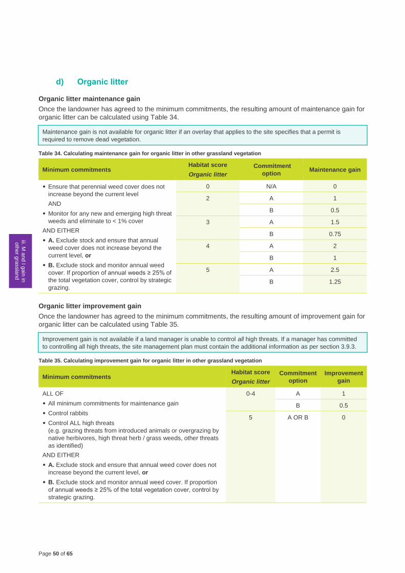
Page 50 of 65
1 G
ain
scorin
g
logic
2.1
Calc
ula
ting th
e
gain
score
- F
reehold
Land
2.2
M a
nd I g
ain
in
woody v
egeta
tion
2.3
M a
nd I g
ain
in
HR
VP
or G
P
gra
ssla
nd
iii. M a
nd I g
ain
in
oth
er g
rassla
nd
2.5
M a
nd I g
ain
in
non‑w
oody
wetla
nd
2.6
M a
nd I g
ain
for re
vegeta
tion
site
s
2.7
Ma
inte
nance
gain
for s
catte
red
tree s
ites
3 C
alc
ula
ting th
e
gain
score
- Cro
wn
Land
4 C
alc
ula
ting th
e
gain
score
d) Organic litter
Organic litter maintenance gain
Once the landowner has agreed to the minimum commitments, the resulting amount of maintenance gain for
organic litter can be calculated using Table 34.
Maintenance gain is not available for organic litter if an overlay that applies to the site specifies that a permit is
required to remove dead vegetation.
Table 34. Calculating maintenance gain for organic litter in other grassland vegetation
Minimum commitments Habitat score
Organic litter
Commitment
option Maintenance gain
• Ensure that perennial weed cover does not
increase beyond the current level
AND
• Monitor for any new and emerging high threat
weeds and eliminate to < 1% cover
AND EITHER
• A. Exclude stock and ensure that annual
weed cover does not increase beyond the
current level, or
• B. Exclude stock and monitor annual weed
cover. If proportion of annual weeds ≥ 25% of
the total vegetation cover, control by strategic
grazing.
0 N/A 0
2
A 1
B 0.5
3 A 1.5
B 0.75
4 A 2
B 1
5 A 2.5
B 1.25
Organic litter improvement gain
Once the landowner has agreed to the minimum commitments, the resulting amount of improvement gain for
organic litter can be calculated using Table 35.
Improvement gain is not available if a land manager is unable to control all high threats. If a manager has committed
to controlling all high threats, the site management plan must contain the additional information as per section 3.9.3.
Table 35. Calculating improvement gain for organic litter in other grassland vegetation
Minimum commitments Habitat score
Organic litter
Commitment
option
Improvement
gain
ALL OF
• All minimum commitments for maintenance gain
• Control rabbits
• Control ALL high threats
(e.g. grazing threats from introduced animals or overgrazing by
native herbivores, high threat herb / grass weeds, other threats
as identified)
AND EITHER
• A. Exclude stock and ensure that annual weed cover does not
increase beyond the current level, or
• B. Exclude stock and monitor annual weed cover. If proportion
of annual weeds ≥ 25% of the total vegetation cover, control by
strategic grazing.
0-4 A 1
B 0.5
5 A OR B 0
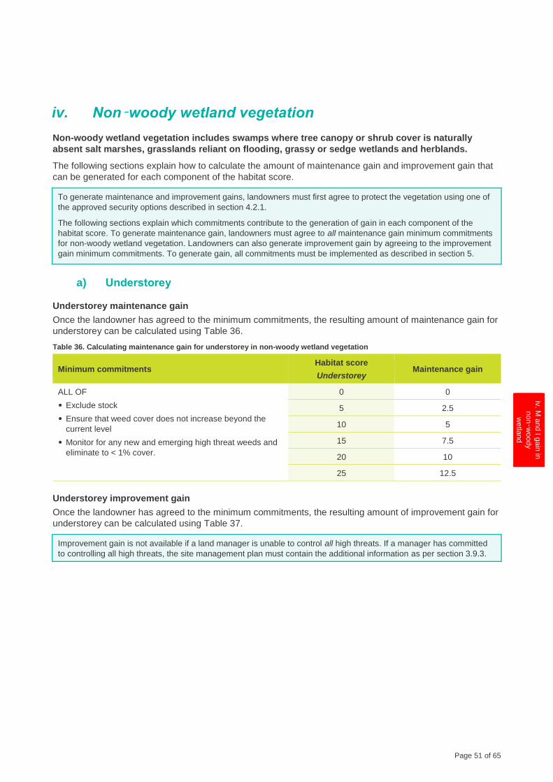
Page 51 of 65
1 G
ain
scorin
g
logic
2.1
Calc
ula
ting th
e
gain
score
-
Fre
ehold
Land
2.2
M a
nd I g
ain
in
woody v
egeta
tion
2.3
M a
nd I g
ain
in
HR
VP
or G
P
gra
ssla
nd
2.4
M a
nd I g
ain
in
oth
er g
rassla
nd
iv. M
and I g
ain
in
non‑w
oody
wetla
nd
2.6
M a
nd I g
ain
for re
vegeta
tion
site
s
2.7
Ma
inte
nance
gain
for s
catte
red
tree s
ites
3 C
alc
ula
ting th
e
gain
score
- Cro
wn
Land
4 C
alc
ula
ting th
e
gain
score
iv. Non‑woody wetland vegetation
Non-woody wetland vegetation includes swamps where tree canopy or shrub cover is naturally
absent salt marshes, grasslands reliant on flooding, grassy or sedge wetlands and herblands.
The following sections explain how to calculate the amount of maintenance gain and improvement gain that
can be generated for each component of the habitat score.
To generate maintenance and improvement gains, landowners must first agree to protect the vegetation using one of
the approved security options described in section 4.2.1.
The following sections explain which commitments contribute to the generation of gain in each component of the
habitat score. To generate maintenance gain, landowners must agree to all maintenance gain minimum commitments
for non-woody wetland vegetation. Landowners can also generate improvement gain by agreeing to the improvement
gain minimum commitments. To generate gain, all commitments must be implemented as described in section 5.
a) Understorey
Understorey maintenance gain
Once the landowner has agreed to the minimum commitments, the resulting amount of maintenance gain for
understorey can be calculated using Table 36.
Table 36. Calculating maintenance gain for understorey in non-woody wetland vegetation
Minimum commitments Habitat score
Understorey Maintenance gain
ALL OF
• Exclude stock
• Ensure that weed cover does not increase beyond the
current level
• Monitor for any new and emerging high threat weeds and
eliminate to < 1% cover.
0 0
5 2.5
10 5
15 7.5
20 10
25 12.5
Understorey improvement gain
Once the landowner has agreed to the minimum commitments, the resulting amount of improvement gain for
understorey can be calculated using Table 37.
Improvement gain is not available if a land manager is unable to control all high threats. If a manager has committed
to controlling all high threats, the site management plan must contain the additional information as per section 3.9.3.
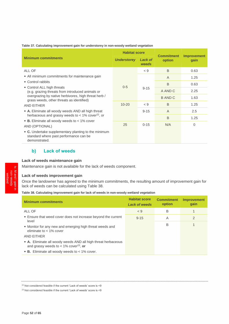
Page 52 of 65
1 G
ain
scorin
g
logic
2.1
Calc
ula
ting th
e
gain
score
- F
reehold
Land
2.2
M a
nd I g
ain
in
woody v
egeta
tion
2.3
M a
nd I g
ain
in
HR
VP
or G
P
gra
ssla
nd
2.4
M a
nd I g
ain
in
oth
er g
rassla
nd
iv. M
and I g
ain
in
non‑w
oody
wetla
nd
2.6
M a
nd I g
ain
for re
vegeta
tion
site
s
2.7
Ma
inte
nance
gain
for s
catte
red
tree s
ites
3 C
alc
ula
ting th
e
gain
score
- Cro
wn
Land
4 C
alc
ula
ting th
e
gain
score
Table 37. Calculating improvement gain for understorey in non-woody wetland vegetation
Minimum commitments
Habitat score Commitment
option
Improvement
gain Understorey Lack of
weeds
ALL OF
• All minimum commitments for maintenance gain
• Control rabbits
• Control ALL high threats
(e.g. grazing threats from introduced animals or
overgrazing by native herbivores, high threat herb /
grass weeds, other threats as identified)
AND EITHER
• A. Eliminate all woody weeds AND all high threat
herbaceous and grassy weeds to < 1% cover22, or
• B. Eliminate all woody weeds to < 1% cover
AND (OPTIONAL)
• C. Undertake supplementary planting to the minimum
standard where past performance can be
demonstrated.
0-5
< 9 B 0.63
9-15
A 1.25
B 0.63
A AND C 2.25
B AND C 1.63
10-20 < 9 B 1.25
9-15 A 2.5
B 1.25
25 0-15 N/A 0
b) Lack of weeds
Lack of weeds maintenance gain
Maintenance gain is not available for the lack of weeds component.
Lack of weeds improvement gain
Once the landowner has agreed to the minimum commitments, the resulting amount of improvement gain for
lack of weeds can be calculated using Table 38.
Table 38. Calculating improvement gain for lack of weeds in non-woody wetland vegetation
Minimum commitments Habitat score
Lack of weeds
Commitment
option
Improvement
gain
ALL OF
• Ensure that weed cover does not increase beyond the current
level
• Monitor for any new and emerging high threat weeds and
eliminate to < 1% cover
AND EITHER
• A. Eliminate all woody weeds AND all high threat herbaceous
and grassy weeds to < 1% cover23, or
• B. Eliminate all woody weeds to < 1% cover.
< 9 B 1
9-15 A 2
B 1
22 Not considered feasible if the current ‘Lack of weeds’ score is <9
23 Not considered feasible if the current ‘Lack of weeds’ score is <9
Page 53 of 65
1 G
ain
scorin
g
logic
2.1
Calc
ula
ting th
e
gain
score
-
Fre
ehold
Land
2.2
M a
nd I g
ain
in
woody v
egeta
tion
2.3
M a
nd I g
ain
in
HR
VP
or G
P
gra
ssla
nd
2.4
M a
nd I g
ain
in
oth
er g
rassla
nd
iv. M
and I g
ain
in
non‑w
oody
wetla
nd
2.6
M a
nd I g
ain
for re
vegeta
tion
site
s
2.7
Ma
inte
nance
gain
for s
catte
red
tree s
ites
3 C
alc
ula
ting th
e
gain
score
- Cro
wn
Land
4 C
alc
ula
ting th
e
gain
score
c) Recruitment
Recruitment maintenance gain
Once the landowner has agreed to the minimum commitments, the resulting amount of maintenance gain for
recruitment can be calculated using Table 39.
Table 39. Calculating maintenance gain for recruitment in non-woody wetland vegetation
Minimum commitments Habitat score
Recruitment Maintenance gain
ALL OF
• Exclude stock
• Ensure that weed cover does not increase beyond the
current level
• Monitor for any new and emerging high threat weeds and
eliminate to < 1% cover.
0 0
1 0.5
3 1.5
5 2.5
6 3
10 5
Recruitment improvement gain
Once the landowner has agreed to the minimum commitments, the resulting amount of improvement gain for
recruitment can be calculated using Table 40.
Improvement gain is not available if a land manager is unable to control all high threats. If a manager has committed
to controlling all high threats, the site management plan must contain the additional information as per section 3.9.3.
Table 40. Calculating improvement gain for recruitment in non-woody wetland vegetation
Minimum commitments
Habitat score Commitment
option
Improvement
gain Recruitment Understorey Lack of
weeds
ALL OF
• All minimum commitments for
maintenance gain
• Control rabbits
• Control ALL high threats
(e.g. grazing threats from introduced
animals or overgrazing by native
herbivores, high threat herb / grass
weeds, other threats as identified)
AND EITHER
• A. Eliminate all woody weeds AND all
high threat herbaceous and grassy
weeds to < 1% cover24, or
• B. Eliminate all woody weeds to < 1%
cover.
0-6 0-5 0-15 N/A 0
10-25 < 9 B 1
9-15 A 2
B 1
10 0-25 0-15 N/A 0
24 Not considered feasible if the current ‘Lack of weeds’ score is <9
Page 54 of 65
1 G
ain
scorin
g
logic
2.1
Calc
ula
ting th
e
gain
score
- F
reehold
Land
2.2
M a
nd I g
ain
in
woody v
egeta
tion
2.3
M a
nd I g
ain
in
HR
VP
or G
P
gra
ssla
nd
2.4
M a
nd I g
ain
in
oth
er g
rassla
nd
iv. M
and I g
ain
in
non‑w
oody
wetla
nd
2.6
M a
nd I g
ain
for re
vegeta
tion
site
s
2.7
Ma
inte
nance
gain
for s
catte
red
tree s
ites
3 C
alc
ula
ting th
e
gain
score
- Cro
wn
Land
4 C
alc
ula
ting th
e
gain
score
d) Organic litter
Organic litter maintenance gain
Once the landowner has agreed to the minimum commitments, the resulting amount of maintenance gain for
organic litter can be calculated using Table 41.
Maintenance gain is not available for organic litter if an overlay that applies to the site specifies that a permit is
required to remove dead vegetation.
Table 41. Calculating maintenance gain for organic litter in non-woody wetland vegetation
Minimum commitments Habitat score
Organic litter
Maintenance
gain
ALL OF
• Exclude stock
• Ensure that weed cover does not increase beyond the current level
• Monitor for any new and emerging high threat weeds and eliminate to < 1% cover
• Retain leaf litter.
0 0
2 1
3 1.5
4 2
5 2.5
Organic litter improvement gain
Once the landowner has agreed to the minimum commitments, the resulting amount of improvement gain for
organic litter can be calculated using Table 42.
Improvement gain is not available if a land manager is unable to control all high threats. If a manager has committed
to controlling all high threats, the site management plan must contain the additional information as per section 3.9.3.
Table 42. Calculating improvement gain for organic litter in non-woody wetland vegetation
Minimum commitments Habitat score
Organic litter Improvement gain
ALL OF
• All minimum commitments for maintenance gain
• Control rabbits
• Control ALL high threats (e.g. grazing threats from
introduced animals or overgrazing by native herbivores,
high threat herb / grass weeds, other threats as
identified).
0-4 1
5 0
Page 55 of 65
1 G
ain
scorin
g
logic
2.1
Calc
ula
ting th
e
gain
score
-
Fre
ehold
Land
2.2
M a
nd I g
ain
in
woody v
egeta
tion
2.3
M a
nd I g
ain
in
HR
VP
or G
P
gra
ssla
nd
2.4
M a
nd I g
ain
in
oth
er g
rassla
nd
2.5
M a
nd I g
ain
in
non‑w
oody
wetla
nd
v. M
and I g
ain
for
revegeta
tion s
ites
2.7
Ma
inte
nance
gain
for s
catte
red
tree s
ites
3 C
alc
ula
ting th
e
gain
score
- Cro
wn
Land
4 C
alc
ula
ting th
e
gain
score
v. Revegetation
Revegetation will only generate gain for woody vegetation types: Heathlands, shrublands (including
samphire shrubland), scrubs, thickets, woodlands, swamps where tree canopy or shrub cover is
naturally present (including lignum swamp), forests and rainforests.
The following sections explain how to calculate the amount of maintenance gain and improvement gain that
can be generated for each component of the habitat score.
To generate maintenance and improvement gains, landowners must first agree to protect the vegetation using one of
the approved security options described in section 4.2.1.
The following sections explain which commitments contribute to the generation of gain in each component of the
habitat score. To generate maintenance gain, landowners must agree to all maintenance gain minimum commitments
for revegetation. Landowners can also generate improvement gain by agreeing to the improvement gain minimum
commitments. To generate gain, all commitments must be implemented as described in section 5.
a) Large trees, lack of weeds, recruitment and organic litter
Maintenance and improvement gains are not available for the large trees, lack of weeds, recruitment or
organic litter components in revegetation sites.
b) Tree canopy cover and understorey (combined)
Tree canopy cover and understorey maintenance gain
Maintenance gain is not available for the tree canopy cover and understorey components in revegetation
sites.
Tree canopy cover and understorey improvement gain
Once the landowner has agreed to the minimum commitments, the resulting combined amount of
improvement gain for tree canopy cover and understorey can be calculated using Table 43.
Improvement gain is not available if a land manager is unable to control all high threats. If a manager has committed
to controlling all high threats, the site management plan must contain the additional information as per section 3.9.3.
Table 43. Calculating the improvement gain for combined canopy and understorey components in revegetation sites
Minimum commitments Commitment
option
Improvement
gain
ALL OF
• Retain all standing trees (dead or alive)
• Exclude stock
• Ensure that weed cover does not increase beyond the current level
• Monitor for any new and emerging high threat weeds and eliminate to < 1%
cover
• Retain logs and fallen timber
• Control rabbits
• Control ALL high threats
(e.g. grazing threats from introduced animals or native herbivores, high threat
herb / grass weeds, other threats as identified)
AND
• A. Eliminate all woody weeds to < 1% cover
AND EITHER
• B. Undertake revegetation to the minimum standard, or
• C. Undertake revegetation to the higher standard where past performance
can be demonstrated (see Appendix 1).
A and B 7
A and C 10
Page 56 of 65
1 G
ain
scorin
g
logic
2.1
Calc
ula
ting th
e
gain
score
- F
reehold
Land
2.2
M a
nd I g
ain
in
woody v
egeta
tion
2.3
M a
nd I g
ain
in
HR
VP
or G
P
gra
ssla
nd
2.4
M a
nd I g
ain
in
oth
er g
rassla
nd
2.5
M a
nd I g
ain
in
non‑w
oody
wetla
nd
v. M
and I g
ain
for
revegeta
tion s
ites
2.7
Ma
inte
nance
gain
for s
catte
red
tree s
ites
3 C
alc
ula
ting th
e
gain
score
- Cro
wn
Land
4 C
alc
ula
ting th
e
gain
score
c) Logs
Logs maintenance gain
Once the landowner has agreed to the minimum commitment, the resulting amount of maintenance gain for
logs can be calculated using Table 44.
Maintenance gain is not available for logs if an overlay that applies to the site specifies that a permit is required to
remove dead vegetation.
Table 44. Calculating maintenance gain for logs for revegetation sites
Minimum
commitment
Length of existing logs as proportion
of benchmark length present Large logs Maintenance gain
Retain logs and fallen
timber
< 10% N/A 0
< 50% Absent 2
≥ 50% Absent 3
< 50% Present 4
≥ 50% Present 5
Logs improvement gain
Once the landowner has agreed to the minimum commitment, the resulting amount of maintenance gain for
logs can be calculated using Table 45.
Table 45. Calculating improvement gain from introduction of logs into revegetation sites
Minimum commitments Length of logs to be introduced as proportion of
benchmark length present
Improvement
gain
ALL OF
• Retain logs and fallen timber
• Introduce logs from DELWP
approved source25.
< 10% 0
≥ 10% 2
d) Landscape context
Revegetation sites can generate gain for improving the landscape context of the site. Revegetation
proposals that meet the minimum size requirement as outlined in Section 3.8 will receive an assigned
landscape context gain score of three points per hectare as outline in Table 46.
Table 46. Calculating improvement gain for landscape context for revegetation sites
Minimum commitment Maintenance gain Improvement gain
Meet the minimum size requirements as outlined in
Section 3.8.
N/A 3
25 Only available in woody vegetation where the understorey score is < 10, the logs are sourced from the native vegetation removal site or DELWP-
approved source, the genera of the trees is indigenous to the site, and logs can be introduced without damaging existing vegetation.
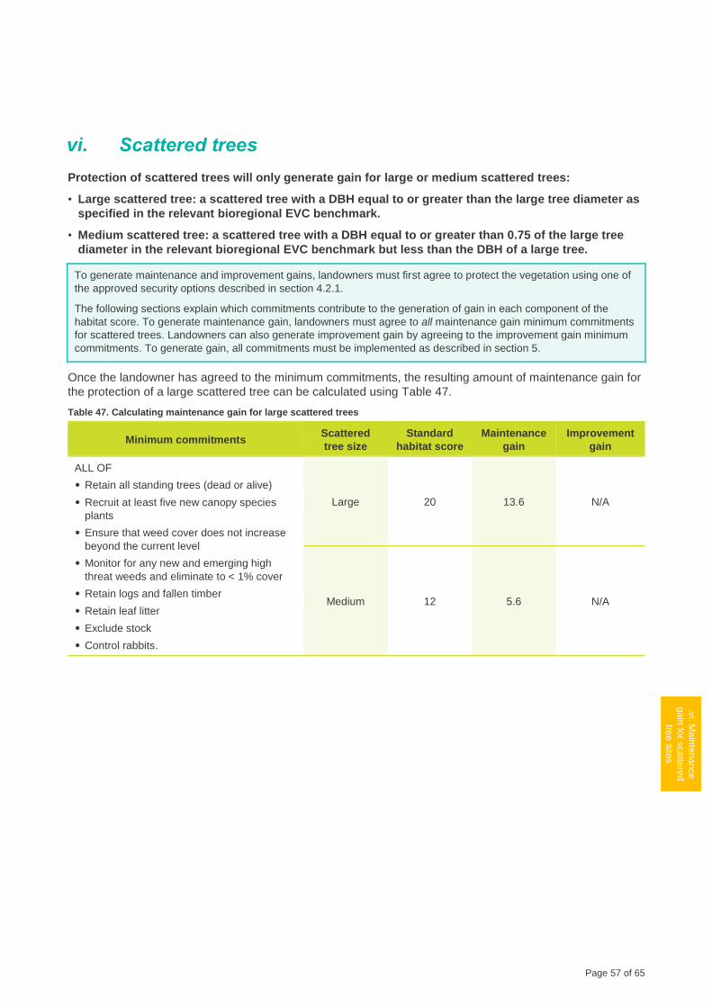
Page 57 of 65
1 G
ain
scorin
g
logic
2.1
Calc
ula
ting th
e
gain
score
-
Fre
ehold
Land
2.2
M a
nd I g
ain
in
woody v
egeta
tion
2.3
M a
nd I g
ain
in
HR
VP
or G
P
gra
ssla
nd
2.4
M a
nd I g
ain
in
oth
er g
rassla
nd
2.5
M a
nd I g
ain
in
non‑w
oody
wetla
nd
2.6
M a
nd I g
ain
for re
vegeta
tion
site
s
.vi. M
ain
tenance
gain
for s
catte
red
tree s
ites
3 C
alc
ula
ting th
e
gain
score
- Cro
wn
Land
4 C
alc
ula
ting th
e
gain
score
vi. Scattered trees
Protection of scattered trees will only generate gain for large or medium scattered trees:
• Large scattered tree: a scattered tree with a DBH equal to or greater than the large tree diameter as
specified in the relevant bioregional EVC benchmark.
• Medium scattered tree: a scattered tree with a DBH equal to or greater than 0.75 of the large tree
diameter in the relevant bioregional EVC benchmark but less than the DBH of a large tree.
To generate maintenance and improvement gains, landowners must first agree to protect the vegetation using one of
the approved security options described in section 4.2.1.
The following sections explain which commitments contribute to the generation of gain in each component of the
habitat score. To generate maintenance gain, landowners must agree to all maintenance gain minimum commitments
for scattered trees. Landowners can also generate improvement gain by agreeing to the improvement gain minimum
commitments. To generate gain, all commitments must be implemented as described in section 5.
Once the landowner has agreed to the minimum commitments, the resulting amount of maintenance gain for
the protection of a large scattered tree can be calculated using Table 47.
Table 47. Calculating maintenance gain for large scattered trees
Minimum commitments Scattered
tree size
Standard
habitat score
Maintenance
gain
Improvement
gain
ALL OF
• Retain all standing trees (dead or alive)
• Recruit at least five new canopy species
plants
• Ensure that weed cover does not increase
beyond the current level
• Monitor for any new and emerging high
threat weeds and eliminate to < 1% cover
• Retain logs and fallen timber
• Retain leaf litter
• Exclude stock
• Control rabbits.
Large 20 13.6 N/A
Medium 12 5.6 N/A
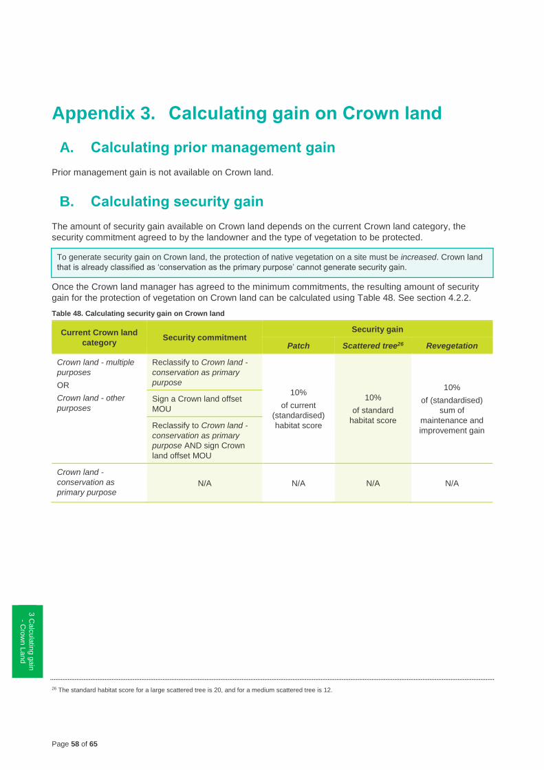
Page 58 of 65
1 G
ain
scorin
g
logic
2.1
Calc
ula
ting th
e
gain
score
- F
reehold
Land
2.2
M a
nd I g
ain
in
woody v
egeta
tion
2.3
M a
nd I g
ain
in
HR
VP
or G
P
gra
ssla
nd
2.4
M a
nd I g
ain
in
oth
er g
rassla
nd
2.5
M a
nd I g
ain
in
non‑w
oody
wetla
nd
2.6
M a
nd I g
ain
for re
vegeta
tion
site
s
2.7
Ma
inte
nance
gain
for s
catte
red
tre
e s
ites
3 C
alc
ula
ting g
ain
- Cro
wn L
and
4 C
alc
ula
ting th
e
gain
score
Appendix 3. Calculating gain on Crown land
A. Calculating prior management gain
Prior management gain is not available on Crown land.
B. Calculating security gain
The amount of security gain available on Crown land depends on the current Crown land category, the
security commitment agreed to by the landowner and the type of vegetation to be protected.
To generate security gain on Crown land, the protection of native vegetation on a site must be increased. Crown land
that is already classified as ‘conservation as the primary purpose’ cannot generate security gain.
Once the Crown land manager has agreed to the minimum commitments, the resulting amount of security
gain for the protection of vegetation on Crown land can be calculated using Table 48. See section 4.2.2.
Table 48. Calculating security gain on Crown land
Current Crown land
category Security commitment
Security gain
Patch Scattered tree26 Revegetation
Crown land - multiple
purposes
OR
Crown land - other
purposes
Reclassify to Crown land -
conservation as primary
purpose
10%
of current
(standardised)
habitat score
10%
of standard
habitat score
10%
of (standardised)
sum of
maintenance and
improvement gain
Sign a Crown land offset
MOU
Reclassify to Crown land -
conservation as primary
purpose AND sign Crown
land offset MOU
Crown land -
conservation as
primary purpose N/A N/A N/A N/A
26 The standard habitat score for a large scattered tree is 20, and for a medium scattered tree is 12.
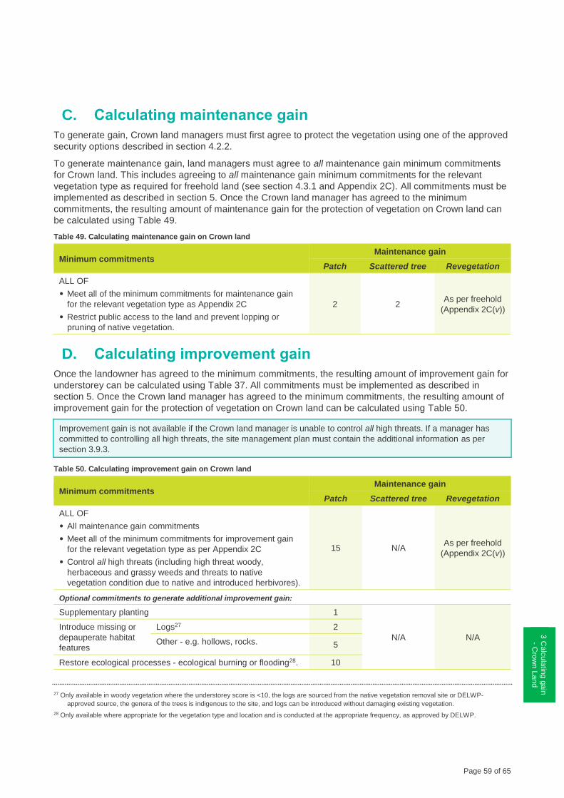
Page 59 of 65
1 G
ain
scorin
g
logic
2.1
Calc
ula
ting th
e
gain
score
-
Fre
ehold
Land
2.2
M a
nd I g
ain
in
woody v
egeta
tion
2.3
M a
nd I g
ain
in
HR
VP
or G
P
gra
ssla
nd
2.4
M a
nd I g
ain
in
oth
er g
rassla
nd
2.5
M a
nd I g
ain
in
non‑w
oody
wetla
nd
2.6
M a
nd I g
ain
for re
vegeta
tion
site
s
2.7
Ma
inte
nance
gain
for s
catte
red
tree s
ites
3 C
alc
ula
ting g
ain
- C
row
n L
and
4 C
alc
ula
ting th
e
gain
score
C. Calculating maintenance gain
To generate gain, Crown land managers must first agree to protect the vegetation using one of the approved
security options described in section 4.2.2.
To generate maintenance gain, land managers must agree to all maintenance gain minimum commitments
for Crown land. This includes agreeing to all maintenance gain minimum commitments for the relevant
vegetation type as required for freehold land (see section 4.3.1 and Appendix 2C). All commitments must be
implemented as described in section 5. Once the Crown land manager has agreed to the minimum
commitments, the resulting amount of maintenance gain for the protection of vegetation on Crown land can
be calculated using Table 49.
Table 49. Calculating maintenance gain on Crown land
Minimum commitments Maintenance gain
Patch Scattered tree Revegetation
ALL OF
• Meet all of the minimum commitments for maintenance gain
for the relevant vegetation type as Appendix 2C
• Restrict public access to the land and prevent lopping or
pruning of native vegetation.
2 2 As per freehold
(Appendix 2C(v))
D. Calculating improvement gain
Once the landowner has agreed to the minimum commitments, the resulting amount of improvement gain for
understorey can be calculated using Table 37. All commitments must be implemented as described in
section 5. Once the Crown land manager has agreed to the minimum commitments, the resulting amount of
improvement gain for the protection of vegetation on Crown land can be calculated using Table 50.
Improvement gain is not available if the Crown land manager is unable to control all high threats. If a manager has
committed to controlling all high threats, the site management plan must contain the additional information as per
section 3.9.3.
Table 50. Calculating improvement gain on Crown land
Minimum commitments Maintenance gain
Patch Scattered tree Revegetation
ALL OF
• All maintenance gain commitments
• Meet all of the minimum commitments for improvement gain
for the relevant vegetation type as per Appendix 2C
• Control all high threats (including high threat woody,
herbaceous and grassy weeds and threats to native
vegetation condition due to native and introduced herbivores).
15 N/A As per freehold
(Appendix 2C(v))
Optional commitments to generate additional improvement gain:
Supplementary planting 1
N/A N/A
Introduce missing or
depauperate habitat
features
Logs27 2
Other - e.g. hollows, rocks. 5
Restore ecological processes - ecological burning or flooding28. 10
27 Only available in woody vegetation where the understorey score is <10, the logs are sourced from the native vegetation removal site or DELWP-
approved source, the genera of the trees is indigenous to the site, and logs can be introduced without damaging existing vegetation.
28 Only available where appropriate for the vegetation type and location and is conducted at the appropriate frequency, as approved by DELWP.
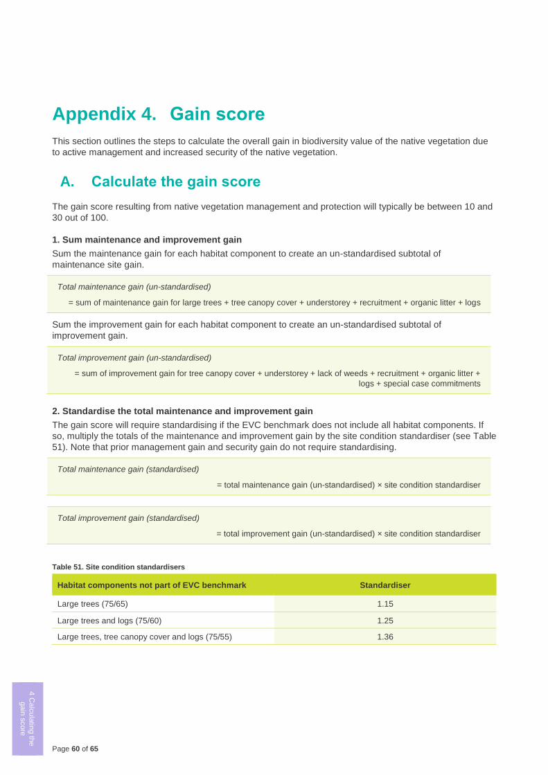
Page 60 of 65
1 G
ain
scorin
g
logic
2.1
Calc
ula
ting th
e
gain
score
- F
reehold
Land
2.2
M a
nd I g
ain
in
woody v
egeta
tion
2.3
M a
nd I g
ain
in
HR
VP
or G
P
gra
ssla
nd
2.4
M a
nd I g
ain
in
oth
er g
rassla
nd
2.5
M a
nd I g
ain
in
non‑w
oody
wetla
nd
2.6
M a
nd I g
ain
for re
vegeta
tion
site
s
2.7
Ma
inte
nance
gain
for s
catte
red
tree s
ites
3 C
alc
ula
ting th
e
gain
score
- Cro
wn
Land
4 C
alc
ula
ting th
e
gain
score
Appendix 4. Gain score
This section outlines the steps to calculate the overall gain in biodiversity value of the native vegetation due
to active management and increased security of the native vegetation.
A. Calculate the gain score
The gain score resulting from native vegetation management and protection will typically be between 10 and
30 out of 100.
1. Sum maintenance and improvement gain
Sum the maintenance gain for each habitat component to create an un-standardised subtotal of
maintenance site gain.
Total maintenance gain (un-standardised)
= sum of maintenance gain for large trees + tree canopy cover + understorey + recruitment + organic litter + logs
Sum the improvement gain for each habitat component to create an un-standardised subtotal of
improvement gain.
Total improvement gain (un-standardised)
= sum of improvement gain for tree canopy cover + understorey + lack of weeds + recruitment + organic litter +
logs + special case commitments
2. Standardise the total maintenance and improvement gain
The gain score will require standardising if the EVC benchmark does not include all habitat components. If
so, multiply the totals of the maintenance and improvement gain by the site condition standardiser (see Table
51). Note that prior management gain and security gain do not require standardising.
Total maintenance gain (standardised)
= total maintenance gain (un-standardised) × site condition standardiser
Total improvement gain (standardised)
= total improvement gain (un-standardised) × site condition standardiser
Table 51. Site condition standardisers
Habitat components not part of EVC benchmark Standardiser
Large trees (75/65) 1.15
Large trees and logs (75/60) 1.25
Large trees, tree canopy cover and logs (75/55) 1.36
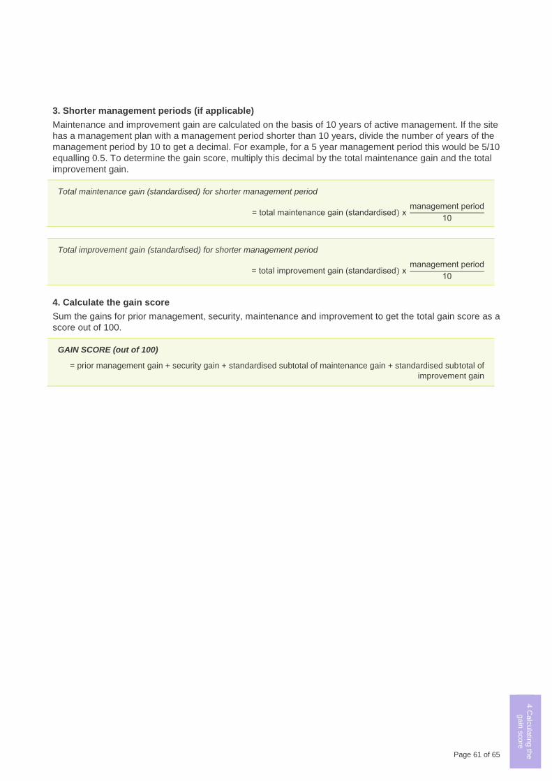
Page 61 of 65
1 G
ain
scorin
g
logic
2.1
Calc
ula
ting th
e
gain
score
-
Fre
ehold
Land
2.2
M a
nd I g
ain
in
woody v
egeta
tion
2.3
M a
nd I g
ain
in
HR
VP
or G
P
gra
ssla
nd
2.4
M a
nd I g
ain
in
oth
er g
rassla
nd
2.5
M a
nd I g
ain
in
non‑w
oody
wetla
nd
2.6
M a
nd I g
ain
for re
vegeta
tion
site
s
2.7
Ma
inte
nance
gain
for s
catte
red
tree s
ites
3 C
alc
ula
ting th
e
gain
score
- Cro
wn
Land
4 C
alc
ula
ting th
e
gain
score
3. Shorter management periods (if applicable)
Maintenance and improvement gain are calculated on the basis of 10 years of active management. If the site
has a management plan with a management period shorter than 10 years, divide the number of years of the
management period by 10 to get a decimal. For example, for a 5 year management period this would be 5/10
equalling 0.5. To determine the gain score, multiply this decimal by the total maintenance gain and the total
improvement gain.
Total maintenance gain (standardised) for shorter management period
= total maintenance gain (standardised) x management period
10
Total improvement gain (standardised) for shorter management period
= total improvement gain (standardised) x management period
10
4. Calculate the gain score
Sum the gains for prior management, security, maintenance and improvement to get the total gain score as a
score out of 100.
GAIN SCORE (out of 100)
= prior management gain + security gain + standardised subtotal of maintenance gain + standardised subtotal of
improvement gain
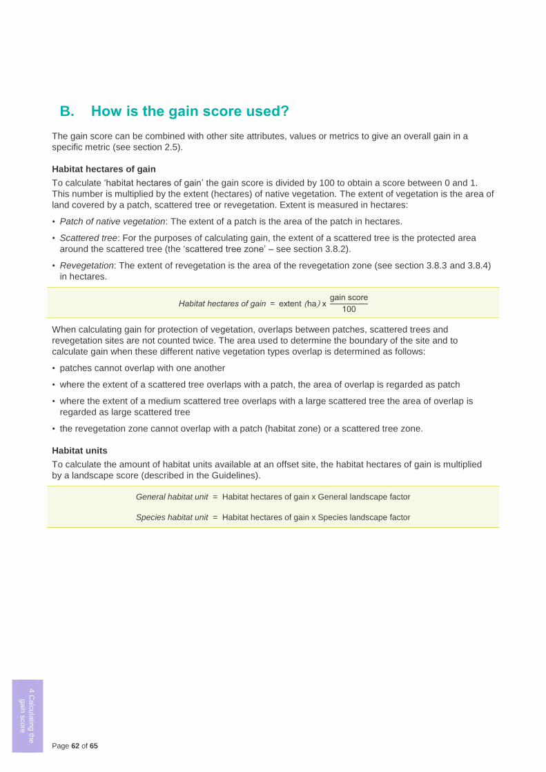
Page 62 of 65
1 G
ain
scorin
g
logic
2.1
Calc
ula
ting th
e
gain
score
- F
reehold
Land
2.2
M a
nd I g
ain
in
woody v
egeta
tion
2.3
M a
nd I g
ain
in
HR
VP
or G
P
gra
ssla
nd
2.4
M a
nd I g
ain
in
oth
er g
rassla
nd
2.5
M a
nd I g
ain
in
non‑w
oody
wetla
nd
2.6
M a
nd I g
ain
for re
vegeta
tion
site
s
2.7
Ma
inte
nance
gain
for s
catte
red
tree s
ites
3 C
alc
ula
ting th
e
gain
score
- Cro
wn
Land
4 C
alc
ula
ting th
e
gain
score
B. How is the gain score used?
The gain score can be combined with other site attributes, values or metrics to give an overall gain in a
specific metric (see section 2.5).
Habitat hectares of gain
To calculate ‘habitat hectares of gain’ the gain score is divided by 100 to obtain a score between 0 and 1.
This number is multiplied by the extent (hectares) of native vegetation. The extent of vegetation is the area of
land covered by a patch, scattered tree or revegetation. Extent is measured in hectares:
• Patch of native vegetation: The extent of a patch is the area of the patch in hectares.
• Scattered tree: For the purposes of calculating gain, the extent of a scattered tree is the protected area
around the scattered tree (the ‘scattered tree zone’ – see section 3.8.2).
• Revegetation: The extent of revegetation is the area of the revegetation zone (see section 3.8.3 and 3.8.4)
in hectares.
Habitat hectares of gain = extent (ha) x gain score
100
When calculating gain for protection of vegetation, overlaps between patches, scattered trees and
revegetation sites are not counted twice. The area used to determine the boundary of the site and to
calculate gain when these different native vegetation types overlap is determined as follows:
• patches cannot overlap with one another
• where the extent of a scattered tree overlaps with a patch, the area of overlap is regarded as patch
• where the extent of a medium scattered tree overlaps with a large scattered tree the area of overlap is
regarded as large scattered tree
• the revegetation zone cannot overlap with a patch (habitat zone) or a scattered tree zone.
Habitat units
To calculate the amount of habitat units available at an offset site, the habitat hectares of gain is multiplied
by a landscape score (described in the Guidelines).
General habitat unit = Habitat hectares of gain x General landscape factor
Species habitat unit = Habitat hectares of gain x Species landscape factor
Page 63 of 65
Accredited native vegetation assessor – A native vegetation assessor listed on DELWP’s Vegetation Quality
Assessment Competency Register. An accredited native vegetation assessor must have current accreditation (less than
two years old at the time the site assessment is completed).
Bioregion – A landscape scale approach to classifying the environment using a range of attributes such as climate,
geomorphology, geology, soils and vegetation. There are 28 bioregions identified within Victoria.
Canopy tree – A mature tree that is greater than 3 metres in height and is normally found in the upper layer of the
relevant vegetation type.
Crown land – Land which is, or is deemed to be, unalienated land of the Crown, as per the definition under the
Conservation, Forests and Lands Act 1987.
Diameter at Breast Height (DBH) – The diameter of the main trunk of a tree measured over bark at 1.3 metres above
ground level.
Ecological Vegetation Class (EVC) – A native vegetation type classified on the basis of a combination of its floristics,
lifeforms, and ecological characteristics.
Extent – The area of land covered by a patch, scattered tree or revegetation, measured in hectares.
First party offset – An offset located on land within the same ownership as the party who has an offset requirement
either general or species.
Freehold land – Land over which the Crown has granted an interest, usually known as ‘ownership’ of land.
Gain – The predicted improvement in biodiversity value of native vegetation due to active management and increased
security of the native vegetation.
Gain score – The sum of prior management gain, security gain, maintenance gain and improvement gain, as relevant.
Habitat hectare assessment – An assessment of native vegetation to determine its condition, extent (in hectares) and
EVC. The assessment must be completed by an accredited native vegetation assessor following methodology described
in the Native vegetation: sustaining a living landscape. Vegetation Quality Assessment Manual – Guidelines for applying
the habitat hectares scoring method, Version 1.3 (VQA manual) (or its successor) and updated in the Assessor’s
handbook.
Habitat hectares of gain – Habitat hectares of gain = extent x gain score/100.
Habitat units of gain – Habitat units of gain = habitat hectares of gain x landscape factor. See Guidelines for the
removal, destruction or lopping of native vegetation for information on landscape factors.
Habitat zone – A discrete area of a patch of native vegetation consisting of a single vegetation type (EVC) with an
assumed similar averaged quality. This is the base spatial unit for conducting a habitat hectare assessment and for
scoring gains from active management and increased security of a patch of native vegetation.
Habitat score – Describes how close native vegetation is to its mature natural state. It is the score assigned to a habitat
zone that indicates the quality of vegetation relative to the EVC benchmark – sum of the site condition score and
landscape context score represented as a score between 0 and 1, as described in Native vegetation: sustaining a living
landscape. Vegetation Quality Assessment Manual – Guidelines for applying the habitat hectares scoring method,
Version 1.3 (VQA manual) (or its successor).
High threat weeds – Weed species that are introduced species (including non-indigenous ‘natives’) with the ability to
outcompete and substantially reduce one or more indigenous habitat components in the longer term, assuming ongoing
current site characteristics and disturbance regime. In the context of gain scoring all woody weeds are considered to be
high threat.
Improvement gain – Improvement gain results from management commitments that improve the current vegetation
condition. Landowners can generate improvement gain where they agree to commitments to improve the vegetation that
are beyond their existing legal management obligations (duty of care).
Indigenous species – Indigenous species occur naturally within a particular area. While this particular area may be
broad (e.g. indigenous to Australia), it is most often used to refer to the local area. For example, plants that occur
naturally in a particular water catchment.
Landscape scale information – Mapped or modelled information based on data collected across the landscape rather
than just on a particular site.
Large scattered tree – A tree with a DBH equal to or greater than the large tree diameter as specified in the relevant
EVC benchmark.
Glossary
Page 64 of 65
Legal management responsibility – A landowner’s legal management responsibilities are duties or obligations under
legislation, the local planning scheme or agreements applying to a property.
Medium scattered tree – A tree with a DBH equal to or greater than 0.75 of the large tree diameter in the relevant EVC
benchmark but less than the DBH of a large tree.
Native vegetation – Native vegetation is defined in the Victoria Planning Provisions as ‘plants that are indigenous to
Victoria, including trees, shrubs, herbs and grasses’.
Native Vegetation Credit Register (NVCR) – A statewide register of native vegetation credits that meet minimum
standards for security and management of sites. The register is administered by the Department of Environment, Land,
Water and Planning, and records the creation, trade and allocation of credits to meet offset requirements.
Native Vegetation Offset Register – A statewide register containing information relating to existing and potential offsets
including the number of habitat units that an offset generates and when these offsets have been used to offset the
removal of native vegetation. The Native Vegetation Offset Register is administered by the Department of Environment,
Land, Water and Planning, and includes the Native Vegetation Credit Register.
Offset – Protection and management (including revegetation) of native vegetation at a site to generate a gain in the
biodiversity, measured in habitat units. An offset is used to compensate for the loss to Victoria’s biodiversity value from
the removal of native vegetation.
Patch – A patch of native vegetation is defined as:
• An area of vegetation where at least 25% of the total perennial understorey plant cover29 is native, or
• Any area with three or more native canopy trees30 where the drip line31 of each tree touches the drip line of at least one
other tree, forming a continuous canopy.
Perennial – A plant that lives for more than two years. Perennials include species that are always visible e.g. shrubs and
trees, but also include species that are not always visible above ground.
Revegetation – Revegetation is the establishment of native vegetation to a prescribed minimum standard in formerly
cleared areas outside a patch or scattered tree.
Revegetation zone – A discrete area of revegetation. This is the base spatial unit for scoring gains from active
management and increased security of an area of revegetation.
Scattered tree – A native canopy tree that does not form part of a patch.
Scattered tree zone – A discrete area of a scattered tree(s). This is the base spatial unit for scoring gains from active
management and increased security of a scattered tree(s).
Security agreement – An ongoing enforceable legal agreement between a landowner and a statutory body which places
legal obligations on the landowner to protect and manage native vegetation. Includes agreements under:
• Section 69 of the Conservation, Forests and Land Act 1987
• Section 3A of the Victorian Conservation Trust Act 1972
• Section 173 of the Planning and Environment Act 1987.
Strategic grazing – A tool to aid in the control of annual weeds and supplement targeted weed control by reducing the
seed set of annual weeds. Usually conducted by introducing high stocking rates of sheep for a short period just before or
at the flowering period of annual weeds.
Statutory body – The statutory body is responsible for administration, monitoring and compliance of the security
agreement. This includes:
• Department of Environment, Land, Water and Planning for agreements under Section 69 of the Conservation, Forests
and Land Act 1987
29 Plant cover is the proportion of the ground that is shaded by vegetation foliage when lit from directly above. Areas that include non-vascular vegetation
(such as mosses and lichens) but otherwise support no native vascular vegetation are not considered to be a patch for the purposes of these
Assessment guidelines. However, when non-vascular vegetation is present with vascular vegetation, it does contribute to cover when determining the
percentage of perennial understorey plant cover.
30 A native canopy tree is a mature tree (i.e. it is able to flower) that is greater than 3 metres in height and is normally found in the upper layer of the
relevant vegetation type.
31 The drip line is the outermost boundary of a tree canopy (leaves and/or branches) where the water drips on to the ground.

Page 65 of 65

Page 66 of 65
•
• Trust for Nature for conservation covenants under section 3A of the Victorian Conservation Trust Act 1972
• Local councils for agreements under Section 173 of the Planning and Environment Act 1987.
Understorey – The lower layers of vegetation, including the shrub layer, grass layer and ground layer. The understorey
may comprise native and non-native species.
delwp.vic.gov.au


![Minato City Environment Master Plan[Digest Version]FY2021](https://img.pdfslide.net/doc/110x75/61cc4356e68f0c0aec64136a/minato-city-environment-master-plandigest-versionfy2021-.jpg)
