Embed Size (px)
Citation preview

FORCE STRUCTURE PLANNING FOR THE MALAYSIAN MARITIME ENFORCEMENT AGENCY∗
Captain (Rtd) Mat Taib bin Yasin, RMN
Encik Azahar Hakim Herriman
∗ Paper prepared for Lima Maritime 2003 Conference ‘Smart Partnership in Managing Future Maritime Security Challenges’ 29 September 2003. This paper has been submitted for external publication. Please do not cite or quote before checking with the authors.

2
Contents: FORCE STRUCTURE PLANNING FOR THE .......................................................................1 MALAYSIAN MARITIME ENFORCEMENT AGENCY ......................................................1
Introduction........................................................................................................................3 Background ........................................................................................................................3 Current Situation ................................................................................................................4 The Challenge ....................................................................................................................5 Cost and Benefit of Maritime Enforcement .......................................................................7 Vessel Force Structure Calculation Methodology ...........................................................10
ASSUMPTIONS..................................................................................................................12 Part One – Assumptions...................................................................................................13
The Role of an Enforcement Patrol Vessel ..................................................................13 Standard Patrol Block ..................................................................................................14 Vessel Types ................................................................................................................16 Operational Regimes....................................................................................................18 Patrol and Response Zones ..........................................................................................18 Other General Assumptions .........................................................................................23
BASELINE VESSEL FORCE MIX ....................................................................................25 Part Two – Baseline Force for Uniform Patrol and Response .........................................26
RECOMMENDED MMEA VESSEL FORCE STRUCTURE ...........................................28 Part Three – Vessel Force Structure for MMEA .............................................................29
Patrol and Response Zone A – Northern Malacca Straits............................................30 Patrol and Response Zone B – Southern Malacca Straits. ...........................................34 Patrol and Response Zone C – Western South China Sea (North) ..............................36 Patrol and Response Zone D – Western South China Sea (South) ..............................40 Patrol and Response Zone E – Eastern South China Sea (West).................................41 Patrol and Response Zone F – Eastern South China Sea (Central) .............................43 Patrol and Response Zone G – Eastern South China Sea (East)..................................45 Patrol and Response Zone H – Sulu Sea......................................................................47 Patrol and Response Zone I – Sulawesi Sea ................................................................48 Summary ......................................................................................................................49
MMEA FORCE STRUCTURE ...........................................................................................51 Conclusion .......................................................................................................................52

3
Introduction In 2002, the Malaysian Federal Government announced that a new coastguard agency is to be formed. The new agency will take over responsibilities and assets from existing maritime enforcement bodies. However, the age of the vessels that are likely to form the initial core force of the new agency suggests that a major capability development program will be needed soon. Moreover, almost none of the existing enforcement fleet is suited to patrol in the outer regions of the Exclusive Economic Zone (EEZ), especially during the heavy weather experienced in monsoon season. Modern enforcement vessels are expensive assets to acquire and operate. Nevertheless, the opportunity cost to the nation of stolen or damaged natural resources, lost excise revenue, and violence or robbery at sea can very much be greater than the cost of enforcement. Therefore, the challenge is to develop a maritime enforcement agency that has the correct number and type of vessels. Too many or too few would both waste valuable resources. The purpose of this essay is to lay out a model to help in the task of determining an appropriate force structure for the new Malaysian Maritime Enforcement Agency (MMEA).1 All assumptions and the process of calculation are documented clearly. In this way, should there be any alteration in the assumptions, the consequences for fleet number and type can be calculated accordingly. Based on the given assumptions, the essay concludes that the MMEA ideally should be equipped with a modern fleet of 39 vessels consisting of: 10 patrol ships (helicopter capable) (80-85m length); 10 medium patrol boats (55-60m length); 15 high-speed patrol boats (>35kt, 35-40m length); and 4 existing ‘Bintang Class’ patrol boats.
Background The ocean links East and West Malaysia, and has been a source of power and prosperity for the country since before the era of the Melaka Sultanate. Then, as now, a key to successful exploitation of ocean wealth is sound governance.2 Effective enforcement is an essential aspect of good ocean governance.3
1 In Malay the name is 'Agensi Penguatkuasaan Maritim Malaysia'. 2 The Melaka Maritime Laws are some of the earliest laws of the sea to have been documented. They were translated by Sir Stamford Raffles in The Maritime Institutions of the Malays, translated from the Malayu Language. Published circa 1820, pp. 130-158. in Tunku Sofiah Jewa, Law of the Sea in Public International Law: A Malaysian Perspective. Vol. II, Pacifica Publications. Kuala Lumpur, 1996. pp. 885-913. 3 Enforcement is a key Government activity and therefore a prime indicator of true public policy for the oceans, i.e. legislation with no enforcement provision might be little more than an extension of political rhetoric. See, Herriman, M. 'Public Policy Aspects of the Development of a National Oceans Policy' Maritime Studies. Nov-Dec 1996. and Herriman, M. 'Options for Ocean Governance in Malaysia' Paper presented at National Conference on Ocean Governance in Conjunction with the Year of the Ocean 1998. Maritime Institute of Malaysia. 16-17 June 1998.

4
Under the United Nations Convention on the Law of the Sea 1982 (LOSC), Malaysia is entitled to, and has declared, a 12 mile territorial sea and an exclusive economic zone out to a distance not exceeding 200 nautical miles from the territorial sea baseline.4 With a coastal low-water line of 4,675km, Malaysia’s maritime estate is now larger than its territorial land area. The wealth and food resources of that maritime estate are growing in importance as improving technology and infrastructure bring them within commercial reach. Marine tourism has also become an important source of wealth for Malaysia and this industry depends on the health and cleanliness of marine waters, beaches and coral reefs. Malaysia’s enforcement arrangements impact directly on the extent to which damaging practices – such as the unauthorised and excessive taking of fish, fish bombing and cyanide fishing,5 marine pollution, and smuggling of coral and other delicate or endangered marine organisms - are minimised. The oceans are also a bridge to Malaysia from other countries. Whilst this is beneficial from the perspective of maritime trade, it opens the door to unwelcome activities such as illegal immigration, smuggling of contraband goods, piracy, terrorism, and foreign intelligence gathering. Malaysia has laws prohibiting these activities, but those laws need to be enforced well if they are to be effective. In addition, Malaysia is a Party to many international treaties that carry obligations for responsible marine management, including enforcement of provisions concerning environmental and safety issues that have the potential to affect Malaysia and neighbouring countries. Current Situation At present, a number of Government agencies have responsibility for various aspects of marine surveillance, search and rescue, and enforcement, which they undertake with varying degrees of success depending on the quality and quantity of the resources available at any given time. These agencies include: The Malaysian Armed Forces (primarily Royal Malaysian Navy); Royal Marine Police; The Department of Fisheries (Marine Resources Protection Unit and Marine Park
Unit); Royal Malaysian Customs; The Marine Department under the Ministry of Transport; and The National Security Division, Prime Minister's Department.
4 As reflected in domestic law, ie Malaysian Emergency (Essential Powers) Ordinance Number 7, 1969; Exclusive Economic Zone Act, 1984. 5 For example, "Sabah used to have the highest catch rate for all states in Malaysia, the 1998 survey shows that catch rate has declined drastically; by nearly 74% since 1974... All fisheries resources that depend directly or indirectly on coral reefs are declining, and fish bombing (blast fishing) and cyanide are the main culprits." See Tropical Research and Conservation Centre (TRACC) @ http://www.tracc.00server.com/Fisheries/destructive_fishing/fisheries_sabah.html

5
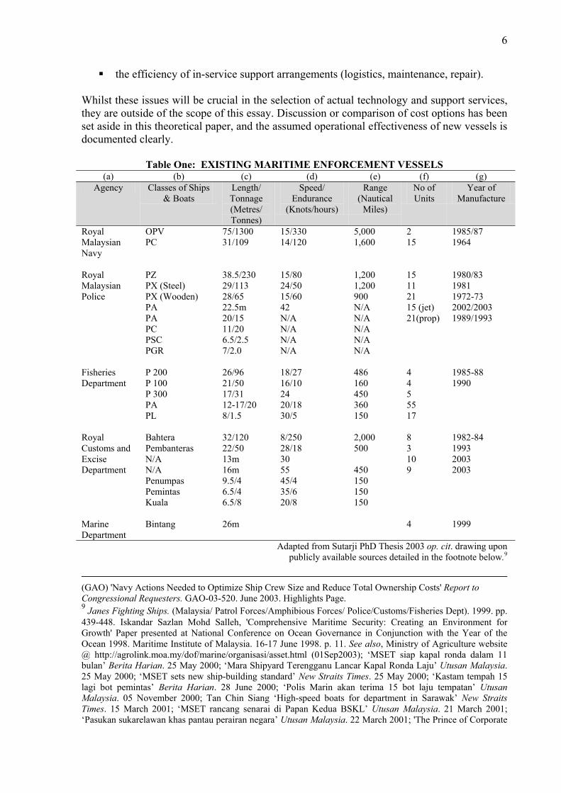
Although each of these agencies is widely respected for its professionalism and effectiveness, historically, they were established in the colonial era and have worked largely independently of each other. Government has recognised the synergistic advantages of replacing this sectoral approach with a single MMEA, and Cabinet has resolved that an MMEA will take national responsibility for all aspects of marine surveillance, search and rescue, and enforcement.6 The Challenge The new MMEA will inherit a range of equipment and systems that will not always have been designed to work together. An inventory of equipment and systems inherited from several different sources (vessels are listed in Table One) is unlikely to fulfil the defined mission and functions of the MMEA. For example, in the entire inventory of existing enforcement vessels (not including warships), only two 75m patrol vessels – currently in service with the RMN – are suitable for heavy weather patrol and response in the outer areas of the EEZ.7 Also, by the year 2010, of the 80 Malaysian patrol vessels (25-40m length) currently in service: 18.8% (15 boats) will be 45-50 years old; 26.2% (21 boats) will be 35-44 years old; 42.5% (34 boats) will be 25-34 years old; and 7.5% (6 boats) will be 20-24 years old.
In total, approximately 88% of the legacy vessels likely to be inherited by the new agency will be out of date (more than 25 years old) by 2010. This figure rises to 95% for vessels over the age of 20 years old. If replacement vessels – some of which would need to be patrol ships – were brought into service at a brisk average rate of one every two months, a total of five years would be required to equip the MMEA with a fleet of 30 modern boats and ships. Therefore, in order to ensure that most of the inefficient, out-of-date vessels (a total of 70 boats) are replaced by 2010, a new fleet program for the MMEA would need to have commenced by no later than 2005, i.e. less than 18 months from the time when this essay is being written. Other factors to be considered in planning future force development for the MMEA include: selection of appropriate technology to fulfil the mission in the most efficient manner
with minimised risk of under-performance or non-performance; human systems integration to ensure effectiveness while minimising through-life
costs;8 and
6 'Coastguard to Boost Maritime Surveillance' New Straits Times 16 April 2002; Lee Lam Thye, 'Coastguard Has Key Role in our Defence' Report of coastguard announcement by Minister of Home Affairs, Datuk Seri Abdullah Ahmad Badawi. New Straits Times. 13 May 2002. 7 TLDM Website 8 "The cost of a ship's crew is the single largest incurred over the ship's lifecycle. One way to lower personnel costs, and thus the cost of ownership, is to use people only when it is cost-effective – a determination made with a systems engineering approach called human systems integration." United States General Accounting Office
6
the efficiency of in-service support arrangements (logistics, maintenance, repair). Whilst these issues will be crucial in the selection of actual technology and support services, they are outside of the scope of this essay. Discussion or comparison of cost options has been set aside in this theoretical paper, and the assumed operational effectiveness of new vessels is documented clearly.
Table One: EXISTING MARITIME ENFORCEMENT VESSELS (a) (b) (c) (d) (e) (f) (g)
Agency Classes of Ships & Boats
Length/ Tonnage (Metres/ Tonnes)
Speed/ Endurance
(Knots/hours)
Range (Nautical
Miles)
No of Units
Year of Manufacture
Royal Malaysian Navy
OPV PC
75/1300 31/109
15/330 14/120
5,000 1,600
2 15
1985/87 1964
Royal Malaysian Police
PZ PX (Steel) PX (Wooden) PA PA PC PSC PGR
38.5/230 29/113 28/65 22.5m 20/15 11/20 6.5/2.5 7/2.0
15/80 24/50 15/60 42 N/A N/A N/A N/A
1,200 1,200 900 N/A N/A N/A N/A N/A
15 11 21 15 (jet) 21(prop)
1980/83 1981 1972-73 2002/2003 1989/1993
Fisheries Department
P 200 P 100 P 300 PA PL
26/96 21/50 17/31 12-17/20 8/1.5
18/27 16/10 24 20/18 30/5
486 160 450 360 150
4 4 5 55 17
1985-88 1990
Royal Customs and Excise Department
Bahtera Pembanteras N/A N/A Penumpas Pemintas Kuala
32/120 22/50 13m 16m 9.5/4 6.5/4 6.5/8
8/250 28/18 30 55 45/4 35/6 20/8
2,000 500 450 150 150 150
8 3 10 9
1982-84 1993 2003 2003
Marine Department
Bintang 26m 4 1999
Adapted from Sutarji PhD Thesis 2003 op. cit. drawing upon publicly available sources detailed in the footnote below.9
(GAO) 'Navy Actions Needed to Optimize Ship Crew Size and Reduce Total Ownership Costs' Report to Congressional Requesters. GAO-03-520. June 2003. Highlights Page. 9 Janes Fighting Ships. (Malaysia/ Patrol Forces/Amphibious Forces/ Police/Customs/Fisheries Dept). 1999. pp. 439-448. Iskandar Sazlan Mohd Salleh, 'Comprehensive Maritime Security: Creating an Environment for Growth' Paper presented at National Conference on Ocean Governance in Conjunction with the Year of the Ocean 1998. Maritime Institute of Malaysia. 16-17 June 1998. p. 11. See also, Ministry of Agriculture website @ http://agrolink.moa.my/dof/marine/organisasi/asset.html (01Sep2003); ‘MSET siap kapal ronda dalam 11 bulan’ Berita Harian. 25 May 2000; ‘Mara Shipyard Terengganu Lancar Kapal Ronda Laju’ Utusan Malaysia. 25 May 2000; ‘MSET sets new ship-building standard’ New Straits Times. 25 May 2000; ‘Kastam tempah 15 lagi bot pemintas’ Berita Harian. 28 June 2000; ‘Polis Marin akan terima 15 bot laju tempatan’ Utusan Malaysia. 05 November 2000; Tan Chin Siang ‘High-speed boats for department in Sarawak’ New Straits Times. 15 March 2001; ‘MSET rancang senarai di Papan Kedua BSKL’ Utusan Malaysia. 21 March 2001; ‘Pasukan sukarelawan khas pantau perairan negara’ Utusan Malaysia. 22 March 2001; 'The Prince of Corporate

7
Cost and Benefit of Maritime Enforcement New enforcement vessels are expensive to build and operate. For example, in 2004, the first of six offshore patrol vessels (OPV) will enter service with the RMN.10 Whilst these ships were built for a Defence role in the EEZ and therefore have a war-fighting capability, they nevertheless constitute an important element of national governance in the EEZ.11 Indeed, this was one aspect of justification put forward for introduction of the OPV. The cost of the six-vessel OPV program is approximately RM5.35 billion.12 Another recent example of the cost of enforcement vessels is the replacement patrol boat program of the Royal Australian Navy (RAN). On 29 August 2003, the Australian Government announced that the RAN is to replace the aging Fremantle Class patrol boats because they are becoming expensive to maintain (built in 1980-1984).13 Twelve new 57m Armidale Class patrol boats with 15 years of through-life maintenance and support will cost about RM1.3 billion ($A550m).14 Although these new aluminium patrol boats will be required to support Defence activities as a secondary duty, they will be built to civilian class standard, i.e. not military specification, and will be used primarily for enforcement duties in the Australian EEZ. In this regard, the Australian new patrol boat program gives a good indication of the likely cost of equipping the MMEA with modern EEZ enforcement vessels. In light of the cost of building and operating new maritime enforcement assets, every effort must be made to ensure that only the required number are in service.15 However, the importance and value of Malaysia's maritime resources and marine business, along with the potential harm to the nation from violations of sovereignty and damage to international reputation,16 also dictate that anything less than the true number of vessels needed would also
Malaysia' The Star. 18 June 2001 @ http://thestar.com.my/news/list.asp?file=/2001/6/18/business/18bm13bs (01Sep2003); Hong Leong Lurssen Shipyard website @ http://hongleonglurssen.com/new02/content/past_achievement2.htm (01Sep2003); MSET Shipbuilding Corporation Sdn Bhd (10754-M) Company Profile. On file with the authors, see also www.marashipyard.com; '16m Customs Patrol Boat' @ http://www.cld.co.nz/customs.htm; for July 2003 announcement of new Swedish 16m Customs patrol boats, see http://www.naval-technology.com/contractors/patrol/dockstavaret/press6.html (01 Sep 2003). 10 See: http://www.geocities.com/Pentagon/Bunker/4875/rmn.html (01 Sep 2003) 11 "protracted negotiations surrounding the plan to construct up to 27 Blohm+Voss MEKO A100 light frigates finally resulted in a contract during November 2000. Prefabricated modules for the first two of the 1,650-ton ships will be supplied by Blohm+Voss, which will provide technical guidance for the transition to total assembly of later ships at Lumut. The 30-knot, 296-foot light frigates will carry eight MM 40 Exocet antiship missiles, a 57-mm dual-purpose gun, and a helicopter, but no antisubmarine systems." Baker, A.D. 'World Navies in Review' Naval Institute Proceedings. http://www.subsim.com/ssr/page43.html (01Sep 2003). 12 'Malaysia Signs Double Deals for OPV Project' Jane's Defence Weekly, February 25, 1998, p. 16; See also, Asia Times On Line. 'Front Page' 29 June 1999 @ http://www.atimes.com/bizasia/AF29Aa06.html (01Sep2003). 13 See Royal Australian Navy website @ http://www.navy.gov.au/ (Force Element Groups) (01Sep2003) 14 Government of Australia (Ministry of Defence) Press Release 109/2003, dated 29 August 2003. 15 "These (Malaysian maritime enforcement) agencies employ 5,300 people and own a total of 480 motor vessels - a comparatively large fleet - including fast customs boats. Government spending on law enforcement at sea, including staff payment, is about RM3 billion a year." See: Bhattacharjee, A. 'Malaysian Coastline Easy Pickings' Asia Times On Line. 22 May 2003. http://www.atimes.com/atimes/Southeast_Asia/EE22Ae01.html (01 Sep 2003). 16 In 2001, Japan announced that it would send regular dispatches of armed patrol vessels to Southeast Asian waters to protect Japanese tankers from piracy. "Under the plan, vessels armed with cannons and machine guns and capable of carrying up to two helicopters will be sent to Southeast Asia four times a year... The waters that Japan will help to patrol include the Malacca Straits...". 'Japan to begin Asian piracy patrols', CNN.com/World 06 June 2001 @ http://edition.cnn.com/2001/WORLD/asiapcf/east/06/06/japan.sea.piracy/index.html; see also

8
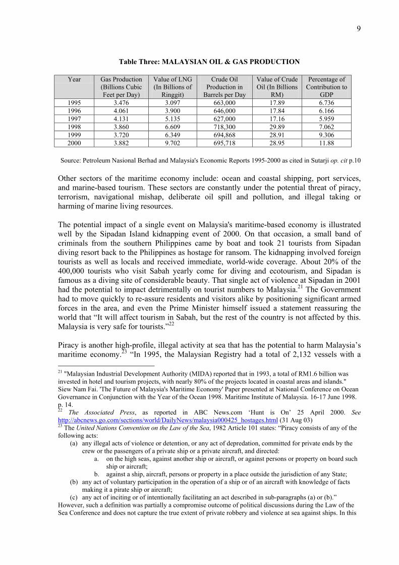
be unacceptable. Any savings made on outlays for enforcement vessels that left the MMEA with insufficient capability would potentially be offset many times over through harm to the national economy. This point is demonstrated amply through consideration of just one factor, ie lost excise revenue: "From January to July 2003 alone, Customs estimates a loss of some RM40 million in revenue for cigarettes and some RM6 million for alcohol beverages... In 2002, total losses were estimated at some RM100 million, with loss of cigarette revenue contributing RM97 million to this figure." The Deputy Director General of the Royal Malaysian Customs, Abdul Rahman Abdul Hamid, is reported to have identified "high powered speed boats and isolated landing places, especially in mangrove areas (as) major points of smuggling in Malaysia".17 Thus, over a fifteen year period (the duration of the Australian new patrol boat program), the loss of excise duty on cigarettes and alcohol alone would more than pay for a fleet of vessels similar to that recently announced for the RAN. However, the value of the maritime estate to Malaysia is far greater than the comparatively small amount represented in customs excise. In 1995, the overall contribution of the maritime sector to the Malaysian economy was calculated to be RM33 billion, which equated to 13% of gross domestic product.18 Tables Two and Three below show the direct value of fishing resources and the offshore petroleum sector to Malaysia. The value of these industries can be threatened by activities such as illegal fishing, illegal and accidental oil spill,19 terrorism, and navigational mishap such as collision or sinking. In 2002, the Minister of Agriculture estimated that encroachment by foreign fishing vessels into the Malaysian EEZ caused the country to lose RM1 billion annually.20
Table Two: STATISTICS ON FISHERIES PRODUCTION
Production in Tonnes
Value in Ringgit Malaysia (RM)
Number of Fishing Vessels
Number of Fishermen
Percentage of Contribution to GDP
1995 1,245,117 3.15 billion 34,906 82,000 1.47% 1996 1,237,997 3.77 billion 33,592 85,230 1.54% 1997 1,280,907 4.35 billion 32,677 78,989 1.57%
Source: Annual Fisheries Statistics 1995 to 1997, Dept of Fisheries Malaysia, as cited in Sutarji op. cit. p. 9.
“India’s spreading naval reach is in part to counter the growing threat of piracy on both sides of the Strait of Malacca.” In ‘India challenges China in South China Sea’ Asia Times Online. 27 April 2000 @ http://www.atimes.com/ind-pak/BD27Df01.html (16 Sep 2003). 17 Ngui, C.Y.K., 'Business Skulduggery', Malaysian Business. August 1st-15th 2003. pp. 47-48. 18 Abdul Aziz Abdul Rahman, Jamali Janib, and Wong Hin Wei, The Maritime Sector and the Malaysian Economy. Malaysian Institute of Maritime Affairs, Kuala Lumpur. 1995. p. 85. 19 "In 1995, out of the 92 reported incidents, 4 were due to oil spills, 88 were due to discharges. The main contaminants found in coastal areas are oil and grease (72 per cent), total suspended solids (53.8 per cent) and Escherichia coli (29.6 per cent). Source: Environmental Quality Report 1996." as cited in Philip Teoh Oon Teong, 'Marine Pollution in Malaysia' Malayan Law Journal. Free Article @ http://www.mlj.com.my/free/articles/philipteoh.htm (08 Sep 2003). 20 The Minister of Agriculture, Datuk Effendi Norwawi said the losses were based on the 14,466 intrusions reported between 1991 and 2000. 'Fisheries Sector Losing RM1b Annually to Foreign Fishermen' New Straits Times. 28 February 2002. Also, for example of near neighbour, "Illegal fishing is said to inflict damages estimated at US$3 billion (sic) (RM3.8 billion) a year." in 'Indon navy needs hundreds of new vessels' New Straits Times. 06 September 2003. p. B19.
9
Table Three: MALAYSIAN OIL & GAS PRODUCTION
Year Gas Production
(Billions Cubic Feet per Day)
Value of LNG (In Billions of
Ringgit)
Crude Oil Production in
Barrels per Day
Value of Crude Oil (In Billions
RM)
Percentage of Contribution to
GDP 1995 3.476 3.097 663,000 17.89 6.736 1996 4.061 3.900 646,000 17.84 6.166 1997 4.131 5.135 627,000 17.16 5.959 1998 3.860 6.609 718,300 29.89 7.062 1999 3.720 6.349 694,868 28.91 9.306 2000 3.882 9.702 695,718 28.95 11.88
Source: Petroleum Nasional Berhad and Malaysia's Economic Reports 1995-2000 as cited in Sutarji op. cit p.10
Other sectors of the maritime economy include: ocean and coastal shipping, port services, and marine-based tourism. These sectors are constantly under the potential threat of piracy, terrorism, navigational mishap, deliberate oil spill and pollution, and illegal taking or harming of marine living resources. The potential impact of a single event on Malaysia's maritime-based economy is illustrated well by the Sipadan Island kidnapping event of 2000. On that occasion, a small band of criminals from the southern Philippines came by boat and took 21 tourists from Sipadan diving resort back to the Philippines as hostage for ransom. The kidnapping involved foreign tourists as well as locals and received immediate, world-wide coverage. About 20% of the 400,000 tourists who visit Sabah yearly come for diving and ecotourism, and Sipadan is famous as a diving site of considerable beauty. That single act of violence at Sipadan in 2001 had the potential to impact detrimentally on tourist numbers to Malaysia.21 The Government had to move quickly to re-assure residents and visitors alike by positioning significant armed forces in the area, and even the Prime Minister himself issued a statement reassuring the world that “It will affect tourism in Sabah, but the rest of the country is not affected by this. Malaysia is very safe for tourists.”22 Piracy is another high-profile, illegal activity at sea that has the potential to harm Malaysia’s maritime economy.23 “In 1995, the Malaysian Registry had a total of 2,132 vessels with a 21 "Malaysian Industrial Development Authority (MIDA) reported that in 1993, a total of RM1.6 billion was invested in hotel and tourism projects, with nearly 80% of the projects located in coastal areas and islands." Siew Nam Fai. 'The Future of Malaysia's Maritime Economy' Paper presented at National Conference on Ocean Governance in Conjunction with the Year of the Ocean 1998. Maritime Institute of Malaysia. 16-17 June 1998. p. 14. 22 The Associated Press, as reported in ABC News.com ‘Hunt is On’ 25 April 2000. See http://abcnews.go.com/sections/world/DailyNews/malaysia000425_hostages.html (31 Aug 03) 23 The United Nations Convention on the Law of the Sea, 1982 Article 101 states: “Piracy consists of any of the following acts:
(a) any illegal acts of violence or detention, or any act of depredation, committed for private ends by the crew or the passengers of a private ship or a private aircraft, and directed:
a. on the high seas, against another ship or aircraft, or against persons or property on board such ship or aircraft;
b. against a ship, aircraft, persons or property in a place outside the jurisdiction of any State; (b) any act of voluntary participation in the operation of a ship or of an aircraft with knowledge of facts
making it a pirate ship or aircraft; (c) any act of inciting or of intentionally facilitating an act described in sub-paragraphs (a) or (b).”
However, such a definition was partially a compromise outcome of political discussions during the Law of the Sea Conference and does not capture the true extent of private robbery and violence at sea against ships. In this

10
combined tonnage of 3.6 million gross registered tons (grt) on its register… It is estimated that 90% of the total value of Malaysia’s external trade is shipped by sea. Malaysia’s exports and imports totaled more than 150 million tones worth more than RM300 billion in 1995 (Economic Report 1995/96).”24 The MMEA will be responsible for protecting this vital economic lifeline from harassment and harm by pirates. In July 2003, the International Maritime Bureau (IMB) announced that piracy had surged 37% to a high of 234 attacks from January to June 2003, leaving 16 seafarers dead. Over a quarter of all attacks occurred in Indonesian waters near Malaysia, and Malaysian vessels have fallen victim to this violent activity.25
Table Four: LOCATION OF ACTUAL AND ATTEMPTED (PIRACY) ATTACKS SHIPS, 1991 – 2000
YEAR 1991 1992 1993 1994 1995 1996 1997 1998 1999 2000
MALACCA STRAITS
32 7 5 3 2 3 - 1 2 75
MALAYSIA 1 2 - 4 5 5 4 10 18 21 80% - 90% of attacks occurring in southern Malacca Straits
Data provided by International Maritime Bureau, Kuala Lumpur26 Therefore, although care must be taken to ensure that Malaysia does not spend valuable resources building up an unnecessarily large maritime enforcement force, so also must every effort be made to equip the new MMEA with sufficient modern vessels to protect the maritime economy. The model developed in this essay considers systematically a number of relevant factors in this important decision-making process. Vessel Force Structure Calculation Methodology An important goal of the methodology chosen for the vessel force structure calculations is for the process to be transparent, easily understood and logical. The first task is to document the
paper, the term ‘piracy’ will be used consistently with the definition provided by the International Maritime Bureau (IMB) which is: “the act of boarding any vessel with the intent to commit theft or other crime and with the capability to use force in furtherance of the act”. IMB Special Report on Piracy, 1992 as cited in Captain Sutarji bin Haji Kasmin RMN, Efficiency Measurement of Malaysia's Maritime Enforcement Agencies using Data Envelopment Analysis. Doctor of Philosophy Thesis, Universiti Putra Malaysia, 2003, p. 16, Footnote 12; "Another threat (from piracy) is environmental... In 1992, pirates boarded a supertanker (in Malacca Straits) and tied up the 24 crew, leaving the seven-storey-high vessel the length of two football pitches to drift among the dangerous reefs and shoals." Macartney, J. (Asian Diplomatic Correspondent), 'Asia piracy costs $25 bln a year, says expert', Reuters News Service 11 December 2002, as cited in Planet Ark @ http://www.planetark.org/dailynewsstory.cfm/newsid/18987/newsDate/11-Dec-2002/story.html (06 Sep 2003). 24 Expanding the Malaysian Fleet: Shipbuilding, Ship-Financing and Implications for Malaysia’s Balance of Payments. Centre for Economic Studies and Ocean Industries, Maritime Institute of Malaysia (MIMA), Kuala Lumpur, November 1997. p. 5. 25 For example, on 10 August 2003, a Malaysian ship, the M.T. Penrider, which was carrying 1,000 tonnes of fuel oil from Singapore to Penang, was attacked by men firing Ak47 and M16 rifles. The captain and two crew-members were kidnapped and taken to Indonesia as hostages for ransom. See, Agence France-Presse (via Clarinet) ‘Malaysian ship attacked, captain and crew kidnapped’ Tuesday, 12 August 2003. (http://quickstart.clari.net/qs_se/webnews/wed/dq/Qmalaysia-piracy.Rsyd_DaD.html); for similar events elsewhere in the Malaysian maritime estate, see ‘Sulu Sea sees pirate hostage takers’ 15 June 2001, CNN.com/ WORLD @ http://edition.cnn.com/2001/WORLD/asiapcf/southeast/06/15/malaysia.kidnap. 26 Courtesy of Captain Azhar Ahmad with thanks.

11
underlying assumptions. The assumptions are described and explained fully in Part One, and include: determination of the area that can be patrolled by a single vessel against a common
standard of coverage and response; determination of classes of vessels to be used in the model; determination of operational regimes that are to be used for the different classes of
vessels; and analysis of the Malaysian maritime estate in order to clarify the size of the area and to
determine workable, clearly delineated patrol and response zones. Part Two of the process draws upon the given assumptions to determine the baseline number of vessels and force mix to provide a standard, uniform level of patrol and response presence throughout the maritime estate. Finally, in Part Three, professional judgement is exercised to vary the outcome of Part Two taking into account the nature of the patrol and response requirements in each particular zone. Allowance is also made in Part Three for the surveillance contribution of land-based fixed-wing aircraft and radar systems. The outcome of the vessel force structure calculations presented in this essay is not intended to be a definitive statement of Malaysia's requirements for an enforcement fleet. Rather, as the conclusion depends upon the accuracy of the assumptions, the outcome is indicative only and may be altered by changes in those assumptions. However, care has been taken to ensure that the assumptions are accurate, sensible and achievable. To that extent, the resultant force structure may be a reasonably good indication of MMEA fleet requirements.

12
FORCE STRUCTURE CALCULATIONS PART ONE ASSUMPTIONS

13
Part One – Assumptions The assumptions used for vessel force structure calculations in this essay are summarised in Part One under the following headings: The Role of an Enforcement Patrol Vessel; Standard Patrol Block; Vessel Types; Operational Regimes; Patrol and Response Zones; and Other General Assumptions.
The Role of an Enforcement Patrol Vessel The assumed role of an MMEA patrol vessel will be to undertake enforcement and SAR tasks including maritime surveillance and response within the Malaysian EEZ, territorial sea and internal waters. This role is expected to entail the following tasks: surveillance and reconnaissance; identification, monitoring and interception of enforcement targets; boarding and searching enforcement targets; executing arrest; escorting, or possibly towing, arrested vessels to port; protecting offshore resources; collecting evidence to support prosecution of environment-related crime; and search and rescue.27
In order to understand the crucial contribution of patrol vessels to the overall enforcement effort, some discussion is required on the attributes of surface vessels and how they differ from other force structure elements such as aircraft or satellites. Surveillance. An enforcement patrol vessel does contribute to the overall surveillance effort; however, in comparison to an aircraft, a patrol vessel is slower and has smaller radar coverage. Therefore, many enforcement agencies throughout the world prefer to use aircraft to provide a broad maritime surveillance picture. Nevertheless, surface vessels also have some advantages over aircraft in the surveillance role and are commonly used to complement air surveillance. The most notable advantage is the sustainability of a vessel's presence. Aircraft are fast and have great range but they also have limited endurance. They tend to give more of a 'snapshot' picture of the maritime situation. In certain circumstances, such a short-term picture can be insufficient to determine the activity of the vessels that have been located. This can be a serious limitation, especially if evidence is needed for legal proceedings against offending vessels. An enforcement patrol vessel remains on duty providing a presence throughout the many hours each day when there is no aircraft on patrol. A patrol vessel can stalk a target, 27 Rear Admiral P. Briggs AM CSC RAN, 'The ADF's Role in Policing the Offshore Zones' in MacKinnon & Sherwood (Eds), Policing Australia's Offshore Zones: Problems and Prospects. Wollongong Papers on Maritime Policy No. 9. Wollongong, 1997. pp. 150-156.

14
covertly collecting crucial evidence on location, speed, and track. Such information might indicate activities such as rendezvous at sea (for smuggling, illegal fish transshipment etc) or piracy. None of which would necessarily be evident from a short-term picture of the target vessel's location. Routine surveillance may also reveal a need for other quick-response requirements, such as board, search, arrest or rescue operations. Board and Search. Another distinct advantage of patrol boats over aircraft is the ability to stop a vessel, board it and inspect its cargo and condition. Patrol boat personnel can also interview the vessel crew and inspect documentation. None of these aspects can be addressed from the air, but they may be essential to discovering whether an offence has occurred. Arrest or Rescue. Lastly, the physical presence of a patrol boat enables the execution of arrest, or in the case of SAR, immediate rescue. The arrest of a vessel and its crew requires the presence of an authorised Government officer in accordance with the relevant legislation for the offence. A maritime enforcement patrol vessel will be crewed with officers who possess the necessary powers of arrest. The arrest of an offending vessel also requires the physical ability to take control of the ship. Only a patrol boat can dispatch a boarding party and if necessary take an arrested vessel in tow to ensure that it proceeds to the appropriate Malaysian port. With regard to SAR, although a search aircraft may be able to drop a life raft and provisions to survivors at sea, only a vessel or helicopter can perform a rescue. However, for operations beyond the first 20 nautical miles from shore, the limited range and endurance of a helicopter will often preclude that option for maritime rescue unless the helicopter is based on a patrol ship. Standard Patrol Block The purpose of the Standard Patrol Block (SPB) is to provide a baseline reference to determine how many and what mix of vessels would be needed to provide uniform surveillance coverage throughout the maritime estate. The SPB assumes a speed of advance of 15 knots and radar coverage radius of 20nm. Although the actual radar range, and therefore time between surveillance contact at any given point in the SPB, will vary according to target, weather and equipment, these variables will be considered in Part Three of the analysis. For the purpose of baseline calculations in Part Two, the important issue is to ensure that a common standard (i.e. SPB) is applied consistently throughout the maritime estate.

15
Diagram One Radar range Standard Patrol Block = 6,000 nm² +20nm = 40nm
20nm averaged factor
allowed for increase in surveillance coverage with helo28
100 nm
B
X
X A
XD
C X 60 nm
Maximum Response Time within the Patrol Block: 116nm @ 20kt = 5.8 hours29 Average Maximum ‘No See’ Time @ 15kt (no helo) = approx 24 hours ‘No See’ time is the length of time that any given point within the SPB would be out of radar or visual range. The SPB profile assumes approximately 520 track nautical miles. At 15kts, a vessel will take 34.6 hours to complete the profile. With a radar coverage radius of 20nm, any given point on the vessel's track will be kept in contact for a period of 2 hours and 40 minutes. However, with track spacing of 20 nm, most points will be seen for less time than this but brought into contact more than once, thus reducing the time between contact. The period between contact increases near the edge and corners of the zone and decreases around the middle area of the zone, eg. in Diagram One, Point A = 22 hours; Point B = 18.6 hours; Point C = 18.6 hours; Point D = 32 hours.
28 One helicopter patrolling 40nm from ship, flying 6hrs per day @ 100kts with radar coverage (at 2,000') of 50nm = [18hrs (no helo) @ 20nm] + [6hrs (helo) @ 90nm] = 900/24hrs = average increase in coverage over 24 hours of 37.5nm, rounded up to 40nm. 29 A patrol ship with helicopter can provide approximately the same frequency of coverage over an area of 1.5 SPB; however, the maximum time for a vessel to respond with its physical presence within the expanded area would increase to 6.7 hours (i.e. 134nm @ 20kt).

16
Vessel Types The MMEA will require a force mix capable of fulfilling its mission in the complex environment of coastal waters and in the expanse of open EEZ ocean. The nature of enforcement and search-and-rescue (SAR) tasks vary with distance from shore. Speed and manoeuvrability are primary factors in coastal waters, whereas sea sustainability and sophisticated surveillance systems become more important in distant EEZ areas. A range of small boats are already in service with the existing enforcement agencies. These vessels are expected to remain operational either as part of the MMEA or with the agencies that currently operate them. Therefore, discussion in this essay does not address riverine or near-shore shallow operations. Territorial Sea and Contiguous Zone. Much of the legacy fleet to be inherited by the MMEA was developed to operate in the territorial sea (to 12nm) and contiguous zone (to 24nm). Indeed, some of these vessels were built before the legal regime of the EEZ had received general international recognition and before Malaysia declared its EEZ in 1980.30 The intended area of operations did not require ships that were capable of broad ocean patrol and response. Accordingly, Malaysia's existing patrol boat fleet consists of vessels almost all of which are less than 40m in length. Whilst such a fleet configuration might seem appropriate for coastal operations, in certain areas (especially the Malacca Straits and Sulu Sea), Malaysia is separated from its neighbours by only a narrow band of sea. The older vessels likely to be inherited by the MMEA are generally slow and may be incapable of interdicting some high-speed offending vessels in the short time available before they enter foreign territorial sea.31 Developments in marine engineering and naval architecture practice have produced vessel designs at 35-40m length that are capable of a high degree of manoeuvrability and speeds in excess of 35 knots. The extra length of these vessels over much of the existing maritime enforcement fleet would afford enhanced sea keeping capability and crew comfort. In light of the Malaysian maritime estate and nature of the enforcement challenges, a modern MMEA fleet will require high-speed patrol boats of this class. In this essay, these vessels are called ‘High-speed Patrol Boats’. Contiguous Zone and Inner-EEZ. In several areas, the Malaysian maritime estate extends well beyond the contiguous zone but not into broad oceanic waters. Such areas would include
30 Proclamation by Prime Minister Dato' Hussein Onn dated 25 April 1980. Full text at: Tunku Sofiah Jewa, Law of the Sea in Public International Law: A Malaysian Perspective. Vol. II, Pacifica Publications. Kuala Lumpur, 1996. p. 364. See also discussion in: Juita Ramli, 'A New Maritime Legal Regime for Malaysia within the Context of Ocean Governance' Paper presented at 'MIMA National Conference on Ocean Governance in conjunction with The Year of the Ocean.' Maritime Institute of Malaysia, Kuala Lumpur, 16-17 June 1998. 31 United Nations Convention on the Law of the Sea 1982 (LOSC). Article 111, Para 1 "The hot pursuit of a foreign ship may be undertaken when the competent authorities of the coastal State have good reason to believe that the ship has violated the laws and regulations of that State. Such pursuit must be commenced when the foreign ship or one of its boats is within the internal waters, the archipelagic waters, the territorial sea or the contiguous zone of the pursuing State, and may only be continued outside the territorial sea or the contiguous zone if the pursuit has not been interrupted..." Para 3 "The right of hot pursuit ceases as soon as the ship pursued enters the territorial sea of its own State or of a third State."
17
the northern part of Malacca Straits; the inner and southern parts of the maritime estate off east-coast Peninsular Malaysia; and the Sulawesi Sea area. Where the EEZ does extend out to the full extent of 200 nautical miles, there remains a need for patrol and response within the first 100 nautical miles that would not always require the services of a patrol ship. However, although high-speed patrol boats in the range of 35-40m length may respond to contingencies at medium distance into the EEZ, they would not do so comfortably for extended duration or in heavy weather. Also, in such an environment, much of their high performance speed and manoeuvrability – designed for rapid intercept in coastal waters – would not be required. Therefore, the force structure calculations in this essay assume that a versatile, medium-sized patrol boat of around 55-60m length would be a useful asset in the force mix for the MMEA. In this essay, these vessels are called ‘Medium Patrol Boats’. Outer EEZ and Hot Pursuit. At distances beyond 100 nautical miles from shore, the broad-ocean nature of the operational environment and associated enforcement / SAR tasks in such EEZ areas require a vessel capable of conducting operations in heavy seas, with long sea sustainability, and the ability to undertake comprehensive surveillance. Moreover, in the event of hot pursuit or SAR response, the patrol ship may well be required to travel beyond the outer limits of the EEZ.32 At such distances from shore, a patrol ship cannot easily be supported by land-based helicopters. Therefore, ideally, the ship would provide a platform for organic air support. However, the operation of a helicopter from a patrol boat of medium size (i.e. 55-60m) would potentially distort the operational utility balance of the vessel (with space required for flight deck, aviation fuel, aviation parts and supporting equipment, flight crew and maintenance crew accommodation, and pyrotechnics storage, etc.). Such a small vessel would probably also offer a challenging landing deck in weather conditions above moderate seas. Thus, the dictates of distant-water patrol and operations suggest a requirement for vessels of greater length than a medium patrol boat. Accordingly, the vessel force structure calculations below include helicopter-capable ships of around 80-85m in length. In this essay, these vessels are called ‘Patrol Ships’.
32 For example, on 28 August 2003, the Uruguayan fishing vessel 'VIARSA' was arrested by Australian authorities after a hot pursuit lasting 21 days across a distance of 3,900 nautical miles. See Goldsmith, B., 'Guards to Escort Suspected Fish Poacher to Australia' Reuters News Service, 29 August 2003.

18
Operational Regimes The operational regimes detailed below are discussed in terms of high-speed patrol boat, medium patrol boat, and (helicopter capable) patrol ship designs. The ratio used in this essay calls for an operational readiness requirement of approximately 66%, which equates to just under 2900 operational days per annum for a squadron of 12 boats. (A) Patrol Ships – Operational Regime
= 20 days at sea = 10 days Operational Response Vessel (ORV)∗ = 12 days rest
8 deployments at 20 patrol days each = 160 days at sea, with a further 80 days as ORV
therefore 2.28 Patrol Ships = 365 days active sea patrol
(B) High-Speed and Medium Patrol Boats – Operational Regime
= 10 days at sea = 4 days Operational Response Vessel (ORV)* = 7 days rest
17 deployments at 10 patrol days each = 170 days at sea, with a further 68 days as ORV
therefore 2.15 x Medium Patrol Boat, or to provide 2.15 x High-Speed Patrol Boat 365 days active sea patrol
Patrol and Response Zones The Malaysian maritime estate extends from the longest international navigation straits in the world (Malacca Straits), across large areas of both the west and east South China Sea, and into the Sulu Sea and Sulawesi Sea (Celebes Sea). The total area of the Malaysian maritime estate is around 152,000 nm².33
∗ Operational Response Vessel must be ready to put to sea within 4 hours of notification. 33 In 1996, upon ratification of the UN Convention on the Law of the Sea 1982, the Malaysian Government issued a declaration that it would not recognise different boundaries for the EEZ and continental shelf (See 'Malaysian Declaration Upon Ratification of the Convention of the Law of the Sea', The MIMA Bulletin Vol. 4, No. 1/97, 1997. p. 14). This position may well prove to be an impediment to concluding EEZ boundaries with neighbours, and such boundaries are yet to be done. However, consistently with the Malaysian Government’s position, the figures quoted in this discussion are based upon an EEZ area of waters superjacent to the continental shelf regime. Should the eventual EEZ be agreed at a lesser area, the difference is unlikely to be great, and Malaysia nevertheless will retain sovereign rights and associated enforcement interests to the limit of the continental shelf.

19
The resources, risk of accident, and threat level varies throughout the maritime estate. For example, piracy and smuggling might be prevalent in some areas, but might not occur in others. Also, oil and gas resources are located in specific areas only. The nature of the resources, risk and threats determines the intensity of patrol and the speed of response required for any given contingency. In turn, these factors will influence the number of vessels needed by the MMEA. Therefore, a sensible framework is needed to segment the maritime estate into Patrol and Response Zones that can be used to describe the differing resources, risks and threats. At present, each of the enforcement agencies uses a separate system to divide the maritime estate into areas of responsibility (AOR). RMN has two Naval Regions (East Coast Peninsular and Eastern South China Sea off Sarawak and Sabah); Royal Marine Police use five Regions which are further divided into 15 Zones (Northern Peninsular, Southern Peninsular, Eastern Peninsular, Sarawak and Sabah); Fisheries Department has nine 'Gewila' with sub-units at each State level; and Royal Malaysian Customs divides the maritime estate using State boundaries for delineation.34 However, these systems of AOR division reflect the responsibilities of existing, sectoral enforcement agencies. They are either too general (eg RMN system) or too localised and coastal to meet the needs of the MMEA. Therefore, for the purpose of vessel force structure calculations in this essay, nine Patrol and Response Zones are designated for the Malaysian maritime estate. These zones are detailed in Table Five and depicted spatially in Diagrams Two and Three.
Table Five: PATROL AND RESPONSE ZONES
Zone
Location
Boundaries
Nautical Miles²
(Number of SPB)
Distance of Outer Boundary from Low Water
Line* A Northern Malacca Strait Int Boundary north of
Langkawi; CS Boundary to Point 8; straight line fm Point 8 to Lumut
13,700nm² (2.28 SPB)
135nm (max)
45nm (min)
B Southern Malacca Strait Straight line fm CS Boundary Point 8 to Lumut; CS Boundary to Point 21; Int Boundary to Johor Baru.
6,400nm²
(1.06 SPB)
45nm (max) 4nm (min) -
excluding narrow strait into JB
C Western South China Sea (North)
Int Boundary to CS Boundary Point 47; CS Boundary to Point 37; straight line fm Point 37 to Kuantan.
29,200nm² (4.86 SPB)
165nm (max)
85nm (min)
34 Sutarji PhD Thesis op. cit. pp. 40-41.

20
D Western South China Sea
(South) Straight line fm Kuantan to CS Boundary Point 37; CS Boundary to Point 22; Point 22 to Johor Baru.
7,600nm²
(1.26 SPB)
88nm (max) 4nm (min) -
excluding narrow strait into JB
E Eastern South China Sea (West)
CS Boundary Point 48 to Point 53; straight line fm Point 53 to Bintulu.
40,600nm² (6.76 SPB)
250nm (max)*
80nm (min) F Eastern South China Sea
(Central) Straight line fm Bintulu to CS Boundary Point 53; CS Boundary to Point 57; straight line fm Point 57 to P. Labuan and across by shortest distance to International Boundary; Int Boundary to mainland.
22,500nm² (3.75 SPB)
Extent of Brunei EEZ claim within Zone F not yet agreed with Malaysia, but allowance made for area of claim within 200nm modified by the presence of Malaysian islands and intruding coastline.35
250nm (max)*
N/A (min)
G Eastern South China Sea (East)
Straight line fm International Boundary to P. Labuan by shortest distance, then to CS Boundary Point 57; CS Boundary to Point 66; Int Boundary to Point 67 and along Int Boundary to intercept straight North-South line along the Western-most edge of P. Banggi; North-South line along the Western-most edge of P. Banggi to mainland near C. Mafsie (NB: Zone G includes Brunei Bay).
22,000nm² (3.66 SPB)
195nm (max)
18nm (min)
H Sulu Sea North-South line fm mainland near C. Mafsie along Western-most edge of P. Banggi to Int Boundary; Int Boundary to Point 73; straight line fm Point 73 to Hull Rock and across to mainland by shortest distance.
1,800nm²
(0.30 SPB)
36nm (max)
7nm (min)
35 Malaysia and Brunei EEZ dispute 2003, see 'PETRONAS Suspends Exploration Offshore Sarawak' Rigzone. 3 July 2003 @ http://www.rigzone.com/news/article.asp?a_id=7235 (3 Sep 2003).

21
I Sulawesi (Celebes) Sea Straight line fm
mainland to Hull Rock by shortest distance; Straight line fm Hull Rock to Int Boundary Point 73; Int Boundary to Point 76; CS Boundary to Point 84.
8,300nm²
(1.38 SPB)
134nm (max)
9nm (min)
∗ Note: Although the breadth of the EEZ cannot exceed 200nm from the territorial sea baselines, Article
7 of the UN Convention on the Law of the Sea 1982 (LOSC) allows States to employ the system of straight baselines under certain circumstances. Malaysia has not declared its territorial sea baselines. The effect of straight baselines can be to extend the territorial sea baselines seaward, sometimes for considerable distance (See Herriman, M. 'China's Territorial Sea Law and International Law of the Sea' Maritime Studies. No. 92. Jan/Feb 1997. p. 17.). The distances of the outer boundary shown in Table One are measured from the low water line, which may not always be the territorial sea baseline. In areas where straight baselines are employed, the area between the low water line and the territorial sea baseline would be ‘internal waters’ and thus would firmly remain within the Malaysian maritime estate for all purposes including enforcement. Article 76 of LOSC limits the breadth of the continental shelf to 350nm in most circumstances.

22
Diagram Two Diagram Three

23
Other General Assumptions Role of small craft. The existing maritime enforcement agencies have a substantial fleet of small patrol boats up to 25m in length. Some of these vessels are very modern and are capable of speeds up to 50 knots.36 For the purpose of this study, responsibility for patrol and response within the first three nautical miles from the shoreline will be met by these small craft. The small craft will also provide first response capability out to 24 nautical miles for enforcement and SAR contingencies, generally to be joined by a larger patrol vessel at the earliest opportunity.
Table Six: SMALL CRAFT PATROL AREA
Zone Length of Coastline Area = Coast Length x 3nm Area Expressed as SPB A 135nm 405nm² 0.06 SPB B 265nm 795nm² 0.13 SPB C 180nm 540nm² 0.09 SPB D 175nm 525nm² 0.08 SPB E 287nm 861nm² 0.14 SPB F 105nm 315nm² 0.05 SPB G 265nm 795nm² 0.13 SPB H 260nm 780nm² 0.13 SPB I 225nm 675nm² 0.11 SPB
De-commissioning of Old Vessels. The vessel force structure calculations assume that all vessels over the age of 25 years (i.e. 95% of the current 25-40m patrol boat fleet by the year 2013) will be de-commissioned. Four ‘Bintang Class’ 26m vessels currently in service with the Marine Department (built 1999) will be treated as ‘High-speed Patrol Boats’ and taken into consideration in Part Three with a discounted weighting factor of 0.5 per boat owing to their smaller size and slower sprint speed (i.e. the four boats will remove the requirement for two of the new, larger high-speed patrol boats). Land-based Air Surveillance. In Part Three of this essay, consideration will be given to the surveillance contribution of land-based fixed-wing aircraft. For the purpose of those calculations, the following assumptions apply: One sortie per day in each Patrol and Response Zone, except Zones B, H and I where
a high threat and risk profile warrants two sorties per day; Aircraft speed 190-195kt TAS; Patrol duration in each zone = 3 hours; Aircraft equipped with surface-search radar, radius of coverage at altitude of 3,000
feet = 70nm.37 Therefore, in a single sortie, an aircraft will fly 580nm, which allows ‘single-look’ radar surveillance (for targets the size of a 100t fishing vessel) of 92,300nm² (approx), i.e. rectangular flight area 100nm x 280nm – see Diagram Four – giving radar coverage area of: 36 '16m Customs Patrol Boat' @ http://www.cld.co.nz/customs.htm. 37 By climbing to higher altitude, modern maritime search radars will achieve good detection of small targets to ranges at almost double this distance; however, a lower altitude allows also for detailed visual search and identification for smaller targets at closer ranges. For an example of a sea search radar system, see discussion on the Canadian Provincial Airlines airborne maritime surveillance system (using Beechcraft King Air 200) @ http://strategis.ic.gc.ca/Ces_Web/_display_air_agriculture_prob_info_.cfm?problemId=1822&target=english (05 Sep 2003).

24
2(100 x 70 [rectangles]) + 2(170 x 140 [rectangles]) + 2(7697 [semi-circles]) + 4 (3448 [quarter-circles]).38 The ‘creeping line ahead’ search pattern depicted in Diagram Four is presented only as an indication of the area of ocean that can be searched in a single sortie with the given parameters. The actual search pattern will be modified for each Patrol and Response Zone to achieve varying degrees of surveillance intensity. However, for consistency and simplicity, the pattern to be employed in each Patrol and Response Zone, and potential distortion caused by factors such as concentration of effort around the inner-coastal area and loiter for investigation, will not be addressed in this essay.
Diagram Four: ‘CREEPING LINE AHEAD’ FLIGHT SURVEILLANCE PATROL
140nm
140nm
100nm 100nm 100nm
Given that no Patrol and Response Zone is larger than 92,300nm², the discussion in Part Three of this essay will assume that every point in each Zone will come under surveillance at least once during each airborne patrol, and that most points will be seen by airborne radar more often than that. Land-based Radar. The MMEA may choose to use coastal radars to conduct surveillance of the maritime estate. The choices would be for either an over-the-horizon radar system for broad coverage of the outer EEZ and its approaches (noting the doughnut effect leaves no coverage by this system nearer to shore), conventional maritime surface-search radar along the coast for surveillance of the first 20-30nm, or a combination of both systems. However, coastal based radar systems of either type are expensive, and require complex planning and evaluation. No attempt is made in this essay to anticipate the outcome of such a strategic decision. Therefore, the only radar system that is taken into consideration in Part Three is the vessel traffic control radar network that is already in place to assist with safety of navigation in the Malacca Straits.
38 The actual performance parameters, including effective search area, can vary considerably between different aircraft and surveillance systems. For a good illustration of this issue, see Naylor, P. 'Command and Control of Civil Coastal and Offshore Surveillance' in MacKinnon & Sherwood (Eds), Policing Australia's Offshore Zones: Problems and Prospects. Wollongong Papers on Maritime Policy No. 9. Wollongong, 1997. pp. 173-174.

25
FORCE STRUCTURE CALCULATIONS PART TWO BASELINE VESSEL FORCE MIX
26
Part Two – Baseline Force for Uniform Patrol and Response The following calculations are used to determine the vessels that would be needed to provide a uniform degree of patrol intensity and response capability (with no allowance yet made for risk, threat, or land-based air and radar surveillance) throughout the maritime estate:
a. note the number of SPB in each Patrol and Response Zone; b. taking into consideration the maximum and minimum distance of the outer
boundary from the shoreline, use the given Operational Regimes to calculate the number of vessels needed of each type to maintain 365 days presence in each SPB; and
c. tally the number of vessels needed for each Patrol and Response Zone and for the Malaysian maritime estate as a whole.
These calculation steps are reflected in Table Seven. The outcome of the calculations are that a force of 45.39 vessels, comprising: 9.12 Patrol Ships; 15.04 Medium Patrol Boats; and 21.23 High-speed Patrol Boats
would be needed to provide a uniform level of surveillance and response throughout the Malaysian maritime estate.

27
Table Seven: VESSEL REQUIREMENTS FOR UNIFORM COVERAGE
Zone Number of
SPB Vessel Type Calculation for
365d Coverage Number of
Vessels A 2.28 Medium @ 1 SPB
High-speed @ 1.22 SPB Small Craft @ 0.06 SPB
2.15 x 1 = 2.15 2.15 x 1.22 = 2.62
2.15 Medium 2.62 High-speed
B 1.06 High-speed @ 0.93 SPB Small Craft @ 0.13 SPB
2.15 x 0.93 = 1.99 1.99 High-speed
C 4.86 Patrol Ship @ 1.5 SPB Medium @ 1.27 SPB High-speed @ 2.00 SPB Small Craft @ 0.09 SPB
2.28 x 1 = 2.28 2.15 x 1.27 = 2.73 2.15 x 2 = 4.3
2.28 Patrol Ships39 2.73 Medium 4.3 High-speed
D 1.26 High-speed @ 1.18 SPB Small Craft @ 0.08 SPB
2.15 x 1.18 = 2.53 2.53 High-speed
E 6.76 Patrol Ship @ 3 SPB Medium @ 2.0 SPB High-speed @ 1.62 SPB Small Craft @ 0.14 SPB
2.28 x 2 = 4.56 2.15 x 2 = 4.3 2.15 x 1.62 = 3.48
4.56 Patrol Ships 4.3 Medium 3.48 High-speed
F 3.75 Patrol Ship @ 1.5 SPB Medium @ 1.2 SPB High-speed @ 1.0 SPB Small Craft @ 0.05 SPB
2.28 x 1.0 = 2.28 2.15 x 1.2 = 2.58 2.15 x 1 = 2.15
2.28 Patrol Ships 2.58 Medium 2.15 High-speed
G 3.66 Patrol Ship @ 1.5 SPB Medium @ 1.03 SPB High-speed @ 1.0 SPB Small Craft @ 0.13 SPB
2.28 x 1 = 2.28 2.15 x 1.03 = 2.21 2.15 x 1 = 2.15
2.28 Patrol Ships 2.21 Medium 2.15 High-speed
H 0.30 High-speed @ 0.17 SPB Small Craft @ 0.13 SPB
2.15 x 0.17 = 0.36 0.36 High-speed
I 1.38 Medium @ 0.5 SPB High-speed @ 0.77 SPB Small Craft @ 0.11 SPB
2.15 x 0.5 = 1.07 2.15 x 0.77 = 1.65
1.07 Medium 1.65 High-speed
39 With Patrol Ships (helicopter carrying) a multiplication factor of 1.0 is used for each 1.5 SPB. See footnote #29.

28
FORCE STRUCTURE CALCULATIONS PART THREE RECOMMENDED MMEA VESSEL FORCE STRUCTURE

29
Part Three – Vessel Force Structure for MMEA Thus far, discussion in this essay has proceeded primarily upon the basis of assumed MMEA performance parameters, which are not specific to any particular location. Only the influence of geography (i.e. area of the maritime estate) has been used to determine a baseline force specific to Malaysia. In Part Three, the nature of the individual Patrol and Response Zones is examined and decisions made on how the baseline force might need to be adjusted to cater to different requirements throughout the maritime estate. The contribution of land-based airborne and terrestrial radar systems is also considered. The natural resources, ocean uses, accident risk and threat of illegal activity all vary considerably throughout the Malaysian maritime estate. A summary of these factors for each Patrol and Response Zone is shown in Table Eight. A history of maritime accidents and incidents in each Zone is shown in Table Nine.
Table Eight: RESOURCES, USES AND THREATS IN MALAYSIAN PATROL ZONES
Zone Primary Natural Resources
Other Primary Economic Uses
Primary Threats / Risks
A Fish Navigation, Tourism Illegal Fishing, Piracy, Terrorism, Smuggling, Illegal Immigration, Collision, Oil Spill
B Fish Navigation Illegal Fishing, Piracy, Terrorism, Illegal Immigration, Smuggling, Collision, Oil Spill
C Fish, Oil & Gas, Island Coral Reefs
Tourism Illegal Fishing, Collision, Oil Spill, Smuggling
D Fish, Island Coral Reefs Tourism Illegal Fishing, Smuggling E Fish, Oil & Gas Tourism Illegal Fishing, Smuggling F Fish, Oil & Gas Illegal Fishing G Fish, Oil & Gas Tourism Illegal Fishing, Fish
Bombing, Illegal Immigration, Smuggling
H Fish Illegal Fishing, Fish Bombing,40 Piracy, Terrorism, Illegal Immigration, Smuggling, Collision, Oil Spill
I Fish, Island Coral Reefs Tourism Illegal Fishing, Fish Bombing, Terrorism, Illegal Immigration, Smuggling
40 '14 Malaysians held, trawlers seized for alleged poaching in Philippines' New Straits Times. Saturday 06 September 2003. p. B19.

30
Table Nine: MARITIME INCIDENTS IN MALAYSIAN WATERS (1995 – 2003)
Zone Ship Fire Collisions Grounding Sinking
A 7 11 7 20 B 15 33 8 72 C 0 1 0 17 D 2 5 0 5
E/F 2 0 1 7 G/H/I 1 1 0 3
Compiled from data provided by Marine Department of Malaysia.41
Patrol and Response Zone A – Northern Malacca Straits The northern sector of the Malacca Straits is an area of strategic importance for Malaysia and for many other countries as well. Internationally, the Malacca Straits are known primarily as a key link in sea lines of communication. However, the northern part of Malacca Straits also produces about half of all Malaysia's marine-capture fish landings.42 Moreover, important marine-based tourism initiatives, especially cruise yachting and beach resorts, depend upon the area being kept safe and clean. The weather conditions of the area produce light to moderate seas, with minimal influence from monsoon. Threats and Risks. Unfortunately, the Malacca Straits are also known internationally as an area that is prone to piracy. Although pirate activities generally originate from the Indonesian side of the Straits,43 they do occur in Malaysian waters and against ships coming and going from Malaysian ports.44 Therefore, justified or not, continuation of piracy in the Malacca Straits leaves Malaysia's reputation for maritime enforcement and crime prevention vulnerable to international criticism. Doubts about enforcement effectiveness in Malacca Straits have resulted in offers of assistance to both Indonesia and Malaysia: "Marine Police Commander Muhamad Muda, however, told AFP that while the exchange of intelligence and experience were always welcome, 'we don't need foreign ships to come into Malaysian waters for joint patrols. I don't think our government would like that sort of thing... Japan has come to my office several times talking about the issue'." 45 Importantly, piracy also has the ability to impact detrimentally on Malaysian maritime trade.46
41 Courtesy of Captain Azhar Ahmad with thanks. 42 "There are about 15,000 traditional and commercial fishing vessels operating throughout the year in this area." A. Abu-Talib (et al.) 'Abundance and distribution of demersal fish resources in the northern part of the Straits of Malacca' in M. Shariff (et al.) (ed's), Towards Sustainable Management of The Straits of Malacca. Universiti Putra Malaysia. Kuala Lumpur. 2000. p. 25. 43 'Pirate attacks have tripled in a decade, IMB report finds' International Maritime Bureau. 01 May 2003, as reported on International Chamber of Commerce website @ http://www.iccwbo.org/home/news_archives/2003/stories/piracy-quarter-1.asp (11 Sep 2003). 44 'New brand of piracy threatens oil tankers in Malacca Straits' ICC Commercial Crime Services, International Chamber of Commerce. Kuala Lumpur. 02 September 2003. @ http://www.iccwbo.org/ccs/news_archives/2003/piracy_ms.asp 45 'Malacca Straits users offer to help M'sia fight piracy' Shipping Times. Singapore. 30 July 2003 @ http://business-times.asia1.com.sg/sub/shipping times/story/0,4574,89348,00.html (14 Sep 2003); '[AFP] New fear of supertanker terrorism in the Malacca Strait' Agence France Presse 10 July 2003. @ http://www.mggpillai.com/print.php3?artid=3280&pda=1 (11 sep 2003). 46 Apart from the obvious potential impact on shipping rates and insurance premiums arising from insecurity over pirate activity, "Crime syndicates in the area (Malacca Straits and Indonesian waters) were believed to be

31
Recently, concern over pirate attacks and arms smuggling has developed into a deeper fear that an even more violent terrorist attack may be directed against shipping in the Malacca Straits.47 Al-Qaeda video footage of Malaysian marine police conducting regular operations in the Malacca Straits was discovered in Afghanistan.48 Also, some commentators have noted that recent incidents of violence against ships in the Malacca Straits seem to have been carried out in a more co-ordinated fashion, using heavier calibre weapons.49 Some suggest that the 'pirates' also appear to have been interested in practising navigation with temporarily captured vessels, and they question whether this type of activity might be directed at preparing for a terrorist attack using a petroleum or liquid natural gas (LNG) carrier.50 The Malacca Straits would be a particularly attractive location for any such terrorist operation because it is a high-profile international navigation route, many Western countries depend on the Malacca Straits for transportation of essential energy resources, and the geography of the straits assists in slowing the ships to ease the task of intercept.51 However, the risk of piracy does not appear to be as high in the northern part of Malacca Straits as it is in the south (Zone B). One reason for the reduced risk is because shipping need not navigate as close to shore as in the narrower, southern portion of the straits. Therefore, the risk of piracy in Zone A is considered to be medium. Nevertheless, without doubt, the very possibility that such a threat exists warrants strict and vigilant maritime crime prevention and law enforcement throughout the Malacca Straits. In Zone A, illegal immigration and smuggling are generally coastal problems coming from Thailand rather than across the strait, which is wide in the northern region and therefore challenging for small craft. The risk of smuggling and illegal immigration in the area is considered to be high.
targeting vessels carrying valuable palm oil and gas oil" 'High seas terrorism alert in piracy report' International Maritime Bureau. 29 January 2003, as reported on International Chamber of Commerce website @ http://www.iccwbo.org/home/news_archives/2003/stories/piracy%20_report_2002.asp (11 Sep 2003). 47 "(In June 2003, the Asian Wall Street Journal) quoted a yet-to-be published report by the East-West Center, a US government think-tank, as saying: 'The nightmare for the United States is that a supertanker will be hijacked and driven into Singapore port, or some other large port, or sunk in the Malacca Strait thus seriously disrupting the flow of oil to East Asia, and potentially blocking US naval mobility and flexibility as well.' " Agence France Press, Posted 10 July 2003, 10.21am @ http://business-times.asia1.com.sg/story/0,4567,87378,00.html (11 Sep 2003); Bradsher, K. 'Warnings from Al Qaeda stir fear that terrorists may attack oil tankers' New York Times. Posted 12 December 2002, in Asia Pacific Initiative. @ http://www.afpc.org/sea121202.shtml (9 Sep 2003); & 'French tanker explosion confirmed as terror attack' International Policy Institute for Counter-Terrorism 10 October 2002. @ http://www.ict.org.il/spotlight/det.cfm?id=837 (11 Sep 2003). 48 [AFP] New fear of supertanker terrorism in the Malacca Strait' Agence France Presse 10 July 2003. op. cit. 49 'New brand of piracy threatens oil tankers in Malacca Straits' ICC Commercial Crime Services, International Chamber of Commerce. Kuala Lumpur. 02 September 2003. op. cit. 50 Australian Broadcasting Corporation, Asia-Pacific Television Newsbroadcast 'News at Noon' 10 Sep 2003. 51 "A quarter of the world's trade passes through the strait. That includes half of all sea shipments of oil, bound for East Asia or sometimes the United States, and two-thirds of the world's shipments of liquefied natural gas." in Bradsher, K., op. cit.; Note 80% of Japan's oil passes through the Malacca Straits. See, Ressa, M. 'Maritime Terror Attack Alert' CNN.com/World. 23 October 2002. @ http://www.cnn.com/2002/WORLD/asiapcf/southeast/10/23/singapore.sealane/index.html (09 Sep 2003); Diamond, J. & Moniz, D. 'Oil tanker explosion called terrorist attack' USA Today. 10 October 2002 @ http://www.usatoday.com/news/world/2002-10-10-yemen-terrorism_x.htm (11 Sep 2003).

32
The oceanography of the Malacca Straits would also appear to create a nutrient-rich environment for marine living resources, somewhat resembling a giant estuary.52 The northern Malacca Straits has a sea bed that is more conducive to trawling activities than is the southern portion of the Straits. Capture fish production from the area is in the order of half a million tonnes per annum.53 Although the semi-enclosed nature of the area mitigates against the intrusion of distant water fishing vessels, there remains a degree of illegal fishing in the northern part of the Malacca Straits. The offenders may be from Thailand and Indonesia; however, they may also be Malaysian vessels fishing in breach of their license provisions or without a license. Finally, a review of the number of navigation related incidents (sinking, collision etc. – see Table Nine) suggests that the threat to the environment from oil spill and risk to the safety of life are higher in the Malacca Straits than elsewhere in the Malaysian maritime estate. Force Structure Adjustments. In the context of threats and risks, the vessel force structure developed for Zone A in Part Two – i.e. 2.15 medium patrol boats and 2.65 high-speed patrol boats – needs to be reviewed to account for local factors. A single airborne surveillance sortie per day will give a maximum 'no see' time for any given point within Zone A of 21 hours. Taking into consideration the nature of the threats and risks, and noting that smugglers and boats transporting illegal immigrants are likely to hug the coastline to allow quick evasion and escape from authorities, this frequency of surveillance is considered adequate for areas beyond three nautical miles from shore. However, for most points beyond three nautical miles, the surveillance contribution of patrolling vessels will reduce the 'no see' time considerably. For near-shore coastal areas, the frequency of surveillance coverage will be determined by the number and type of small craft on patrol, which, although expected to be much more intensive, is a question outside the scope of this paper. The contribution of shore-based radar and other surveillance options will also serve to reduce further the 'no see' time within the coastal zone, which is the area of highest crime risk. Therefore, the surveillance requirements of Zone A do not necessitate any change in the vessel numbers determined in Part Two. The number of enforcement vessels required for Zone A is determined by response time, not surveillance intensity. In the Zone A coastal area – up to 24 nautical miles from the shoreline – the maximum time assumed for vessel response to an enforcement or SAR contingency is 4 hours. The vessel numbers developed in Part Two were based upon a maximum response time of 5.8 hours for a single vessel patrolling one SPB; however, the required reduction in maximum response time can be achieved by an increased speed of transit by high-speed patrol boats (29 knots), or by the use of smaller intercept and pursuit craft (< 25m length) – that normally patrol within three nautical miles from shore – to provide temporary first response. Therefore, for Zone A, no recommendation is made for an increase in the number of high-speed patrol boats to reduce the maximum time needed to respond in the coastal area.
52 Dato Mohd Mazlan Jusoh, ‘Management of living aquatic resources in the Straits of Malacca’ in M. Shariff (et al.) (ed's), Towards Sustainable Management of The Straits of Malacca. Universiti Putra Malaysia. Kuala Lumpur. 2000. p. 19. 53 A. Abu-Talib (et al.) 'Abundance and distribution of demersal fish resources in the northern part of the Straits of Malacca' in M. Shariff (et al.) (ed's), Towards Sustainable Management of The Straits of Malacca. Universiti Putra Malaysia. Kuala Lumpur. 2000. p. 25.

33
The maximum time assumed for vessel response beyond 24 nautical miles is 8 hours. This requirement is exceeded by the normal parameters of a single vessel patrol in a SPB (5.8 hours maximum response time). A response time of 8 hours would enable a single vessel to patrol two SPBs.54 Table Ten
Measurement Total Area of Zone A Area Patrolled by Small Craft
Area for 4 Hour Response
Area for 8 Hour Response
Square Nautical Miles
13,700 405 2,835 10,460
Standard Patrol Blocks
2.28 0.06 0.5 1.72
Therefore, the multiplication factor used in Table Seven of Part Two should be revised to a factor of 1.0 for an area of two SPBs beyond 24 nautical miles from shore. The resulting vessel requirements would be 2.28 SPB (total area of Zone A) – 0.06 SPB (area patrolled by small craft) – 0.5 SPB (area between 3nm and 24nm of the coastal zone55) = 1.72 SPB; therefore, where 2.15 boats can now provide 24 hour patrol over an area of 2 SPB, the required number of vessels is reduced to 2.15 x 0.86 = 1.85 boats; plus, 2.15 x 0.5 SPB = 1.08 boats (for coastal area), giving a total force requirement of 2.93 boats (see Table Ten). However, a dilemma arises as to the choice of vessel type. The capabilities of the high-speed patrol boats recommended by this study would allow those vessels to assume responsibility for some of the non-coastal area allocated to the medium patrol boats in Part Two, Table Seven. However, limitation in size would preclude the use of such vessels for extended duties out to 100nm from the coast, and would prove to be a constraint in the event that a hot pursuit was necessary to apprehend a vessel fleeing north into the Andaman Sea. On the other hand, the slower speed of medium patrol boats would prevent them from guaranteeing response within the coastal zone within 4 hours, and would put added pressure on the small craft force to take up this first-response requirement out to 24 nautical miles. At first blush, a compromise combination of two vessels of one type and one of the other might seem a solution to the needs of Zone A. However, a single vessel cannot provide 24 hour presence of its type in the Zone, and for the duration when that vessel was in port, either the problem of patrol presence in the outer region or response capability in the coastal zone would not be addressed. Thus, the recommended number of MMEA patrol vessels for Zone A is: Two medium patrol boats; and Two high-speed patrol boats.
54 At 100nm x 120nm (ie 2 x SPB), the maximum distance to respond is 156.2nm, which takes 7.81 hours @ 20 kts. Although at 200nm x 60nm (ie also 2 x SPB) the maximum distance to respond would be 209nm, which takes 10.45 hours @ 20 kts, the coastline of Zone A is 135nm long, and the maximum distance of the outer boundary from the shoreline is also 135nm, which precludes such an operational patrol arrangement. 55 135nm length of coast x 21nm = 2,855nm², or approx 0.5 SPB.

34
Patrol and Response Zone B – Southern Malacca Straits. The southern sector of the Malacca Straits is just as important to international and domestic sea trade as the northern part of the Straits. However, marine-capture fish landings are not as bountiful in the southern part of Malacca Straits. Nevertheless, there are many small fishing vessels in the area from both Malaysia and Indonesia. Marine-based tourism remains a lucrative industry with beach resorts and a major marina located at Port Dickson, and other facilities along the coast especially around the town of Melaka. Generally, the weather conditions in the area produce light sea; however, sea can become moderate especially under the influence of a 'Sumatran wind' (NW). Monsoon influence in the area is minimal. Threats and Risks. The narrow geography of the southern part of Malacca Straits and vessel traffic congestion combine to heighten the threat of piracy, smuggling and navigation mishap. In the first three months of 2003, the International Maritime Bureau (IMB) reported 103 actual pirate attacks around the world. The geographical dispersion of these attacks is shown at Diagram Five.
Diagram Five: REPORTED PIRACY INCIDENTS IN FIRST QUARTER 2003
���������������������������������������������������������������������������������������������������������
�������������������������������������������������������������������������������������������������������������������������������������������������������������������������������������������������������������������������
���������������������������������������������������������������������������������������������������������������������������������������������������������������������������������������������������������������������������������������������������������������������������������������������������������������������������������������������������������������������������������������������������������������������������������������������
������������������������������������������������������������������������������������������������������������������������������������������������������������������������
��������������������������������������������������������������������������������������������������������������������������������������������������������������������������������
���������������������������������������������������������������������������������������������������������������������������������������������������������������������������������������������������������������������������������������������������������������������������������������������������������������������������������������������������������������������������������������������������������������������������������������������������������������������������������������������������������������������������
69
28
99
42
���������������������������������������������
Red SeaNigeriaIndonesiaBangladeshIndiaOther
Source: International Chamber of Commerce, 'Pirate attacks have tripled in a decade, IMB report finds' op. cit. The IMB notes that "A total of 145 seafarers were reported killed, assaulted, kidnapped or missing in the first quarter of 2003."56 By June 2003, the number of pirate attacks world-wide had grown to 234 cases with one quarter or 64 of these in Indonesian waters. Of the Indonesian attacks, four ships were hijacked, 43 boarded, while attempted attacks were made on another 17 vessels.57 The southern part of the Malacca Straits and its approaches remain
56 As reported in, Dicus, H. 'Piracy increases in South China Sea' Pacific Business News. 03 May 2003. @ http://pacific.bizjournals.com/pacific/stories/2003/04/28/daily83.html (14 Sep 2003). 57 'Malacca Straits users offer to help M'sia fight piracy' Shipping Times. Singapore. 30 July 2003 @ http://business-times.asia1.com.sg/sub/shipping times/story/0,4574,89348,00.html (14 Sep 2003).

35
one of the most dangerous areas for pirate attack in the world.58 Accordingly, the threat of piracy in Zone B is considered to be high. However, the piracy situation was not always as serious in Malacca Straits as it is today: "Before 1989, piracy in the strategic Malacca Straits that link shipping lanes between Europe and Asia was rare, about seven cases a year, but in 1989 the figure leapt to 28 and by 1991 the number of reported cases had soared to 50."59 There is evidence to show that determined and effective enforcement efforts do reduce the incidence of piracy. For example, between 2000 and 2001, increased patrols by Malaysia and Singapore managed to reduce the number of pirate attacks in their portion of the Malacca Straits from 75 to 17.60 Therefore, the effectiveness of the MMEA in Zone B will likely have a significant bearing on the incidence of piracy in the area. Smuggling and illegal immigration are also a serious problem in Zone B.61 In general, smuggled goods and people come across the narrow waterway from Indonesia. In 1999, the Malaysian Maritime Enforcement Coordination Centre (MECC) estimated that 160,000 illegal immigrants, of a total Indonesian illegal immigration population of 325,000 in Peninsular Malaysia, were smuggled through the Straits of Malacca.62 The average distance across the Straits in this zone is less than 20 nautical miles. At a speed of 30 knots, a vessel would take only 40 minutes to cross from one side of the Straits to the other. Smugglers' boats are sometimes capable of speeds of more than 35 knots. As with Zone A, the semi-enclosed geography of the southern Malacca Straits combined with a high number of small fishing craft and heavy shipping traffic discourage the presence of distant water fishing vessels. Consequently, most illegal fishing in the area is done by encroaching Indonesian fishing boats or by Malaysian vessels fishing in breach of their license provisions or without a license. The Malacca Straits are extremely busy in Zone B. Over 600 ships pass through the area each day: "the Straits of Malacca... carry three times the oil volume of Suez Canal and are 15 times as busy as the Panama Canal."63 Statistics provided by the Malaysian Marine Department (see Table Nine) show that many more incidents of ship fire, collision, grounding and sinking occur in Zone B than in any other area of the Malaysian maritime estate. The possibility of
58 Warren, J. School of Asian Studies at Murdoch University, as reported in Macartney, J. 'Asia piracy costs $25 bln a year, says expert', Reuters News Service. Singapore. 11 December 2002. @ http://www.planetark.org/dailynewsstory.cfm/newsid/18987/newsDate/11-Dec-2002/story.html (14 Sep 2003). 59 Loc. cit. 60 Boyd, A. 'Piracy: Terror on the high seas' Asia Times Online. Hong Kong. 21 August 2002 @ http://www.atimes.com/atimes/Asian_Economy/DH21Dk01.html (14 September 2003). 61 See discussion earlier in this paper. As an example, "in Selangor, a Customs boat with four officers from the Malacca Smuggling Preventive branch, was surrounded by 15 enemy boats which tried to obstruct them from discharging their duties at Sabak Bernam, Selangor. Malacca Customs Preventive Branch director Makhtar Abdullah said at that time the Customs boat had detained three boats with a cargo of keretek and liquor. Some 40 people using fishing boats and sampans surrounded the Customs boat, he said. The blockade lasted an hour from 4.30 am. Mr Makhtar said 38,000 cartons of keretek cigarettes, valued at RM625,800 (S$275,352), and 100 cartons of brandy and whisky were seized from the three boats. Unpaid import duty on the cigarettes and liquor was estimated at RM1.61 million". 'Malacca Strait piracy heading for 10-year high – Indonesia unrest fallout' The Straits Times. 10 October 2000. @ http://www.hartford-hwp.com/archives/54/185.html (14 Sep 2003). 62 Sutarji, op. cit., p. 49. 63 Boyd, A. 'Piracy: Terror on the high seas' Asia Times Online. Hong Kong. 21 August 2002 @ http://www.atimes.com/atimes/Asian_Economy/DH21Dk01.html (14 September 2003);

36
navigation mishap carries consequent risk for safety of life, the economy and the environment. Force Structure Adjustments. In the context of threats and risks, the vessel force structure developed for Zone B in Part Two – i.e. 1.99 high-speed patrol boats – needs to be reviewed to account for local factors. The threat of piracy, smuggling, illegal immigration and navigational mishap are all considered to be high in Zone B. Therefore, a total of two airborne surveillance sorties are assumed to take place each day. Two sorties per day would give a maximum 'no see' time for any given point within the zone of 9 hours, which is considered adequate for the area beyond three nautical miles from shore. As in Zone A, the frequency of near-shore patrol by small craft is expected to be intensive within the three nautical mile area. Also consistently with Zone A, the contribution of shore-based radar and other surveillance will further reduce the 'no see' time within the coastal zone. Therefore, the surveillance requirements of Zone B do not necessitate any change in the vessel numbers determined in Part Two. Throughout Zone B, the maximum time assumed for vessel response to an enforcement or SAR contingency is one hour.64 The vessel numbers determined for Zone B in Part Two were based upon a maximum response time of 5.8 hours for a single vessel patrolling one SPB. The coastline of Zone B is very long at 265 nautical miles; therefore, even though the full depth of a SPB cannot be achieved in Zone B, the length of transit for response could exceed the 116 nautical mile distance upon which the standard response time is based. Even if the response time for Zone B was doubled to two hours, in order for a single patrol vessel to respond within that time at a maximum distance of 250nm, the patrol boat would need to transit at 125 knots, which is quite impossible. Even at half that distance the vessel would need to transit at 62.5 knots. However, the Malacca Straits are narrow in Zone B, with much of the area less than 20 nautical miles wide. Therefore, rather than increase the number of expensive high-speed patrol boats deployed in Zone B, the study assumes that smaller intercept and pursuit craft (< 25m length) will be used to provide first response throughout the zone. Because the Malacca Straits become very narrow in the southern portion of the zone, follow-up response by a larger, high-speed patrol boat would probably only be necessary or practical in the northern part of Zone B, and in most cases this would occur well within 4 hours (i.e. 80nm @ 20kts). Therefore, the recommended number of MMEA patrol vessels for Zone B remains at a rounded-up figure of two high-speed patrol boats. Patrol and Response Zone C – Western South China Sea (North) The northern sector of Malaysia’s western South China Sea maritime estate is an area that is rich in oil and gas (see Diagram Six), and that supports an important peninsular East Coast fishing and tourism industry. There are coral reef marine parks located around islands in Zone C. The weather conditions in the area produce light to moderate seas; however, during the monsoon season (October to February) the seas can become moderate to high. 64 A vessel traveling at 20kts would take one hour to cross 20nm from one side of the Straits to the other. Although some vessels are capable of higher speeds than this, and the distance is frequently shorter, one hour is considered to be the fastest practicable target response time.

37
Diagram Six

38
Threats and Risks. The main threats of criminal activity in Zone C are coastal smuggling and illegal immigration from Thailand to the north, and illegal fishing. There is not a strong history of piracy in Zone C. Smuggling in the area can include items such as rice, drugs, arms, and diesel fuel.65 Illegal fishing involves both the presence of unlicensed foreign vessels (including vessels from Thailand) and Malaysian boats fishing in violation of their license provisions. Illegal fishing can also include the transshipment of fish catch at sea from Malaysian fishing boats to foreign vessels. Moreover, Marine Department statistics show a high incidence of vessel sinkings in the Zone (see Table Nine), which raises the risk of environmental damage through oil spill and loss of life or casualty. The threat of smuggling, illegal immigration and illegal fishing are all considered to be high; however, smuggling and illegal immigration are most likely to occur in near-shore areas. Only the threat of illegal fishing remains high in the area beyond three nautical miles from shore. The threat of navigation mishap causing pollution or injury is also high. The threat of piracy or terrorist attack against offshore petroleum installations is considered to be low, but potentially would be of strategic significance if it were to occur. Force Structure Adjustments. Zone C is the second largest Patrol and Response Zone and is by far the largest Zone in West Malaysia (29,200nm²). The outer boundary of Zone C is 165 nautical miles from shore. Therefore, the baseline vessel force developed in Part Two includes a requirement for patrol ships to operate in the outer-most SPB. However, in the context of threats and risks, the baseline force structure – 2.28 patrol ships, 2.73 medium patrol boats and 4.3 high-speed patrol boats – needs to be reviewed to account for local factors. Airborne surveillance would be based on a single sortie each day with maximum 'no see' time for any given point within Zone C of 21 hours. In the context of the identified threats and risks, this frequency of surveillance is adequate for areas beyond three nautical miles from shore. The considerations discussed for Patrol and Response Zone A regarding airborne surveillance remain relevant for Zone C. Therefore, from the perspective of surveillance, the contribution of airborne patrol removes any need for revision of the number of enforcement vessels determined in Part Two. The use of land-based systems for surveillance in the coastal zone would only improve coverage further and, in doing so, reinforce a conclusion that the number of vessels required is determined by response time, not surveillance intensity. In the relevant part of the Zone C coastal area – i.e. beyond three nautical miles and up to 24 nautical miles from the shoreline – the maximum time assumed for vessel response to an enforcement or SAR contingency is 4 hours. In the baseline calculations, the two SPBs closest to shore are assumed to be patrolled by high-speed patrol boats. Therefore, as with Zone A, the required response time can be achieved by an increased speed of transit (29 knots), or by the use of smaller intercept and pursuit craft to provide temporary first response. However, unlike Zone A, the weather in Zone C can produce seas that are too rough for either of these options. Nevertheless, the threat of crime during such periods of high sea state would also be lessened because of an overall reduction in the level of activity at sea.
65 Smuggling is done from illegal jetties along the coast in Thailand and Kelantan, in 'Rice Glut May Swamp Farmers' Ministry of Agriculture website @ http://agrolink.moa.my/moa1/newspaper/pemasaran/nm200110114.html (17 Sep 2003); ‘Malaysia to step up border security to curb arms smuggling’ Daily News. Sri Lanka, 27 July 2002 @ http://www.dailynews.lk/2002/07/27/wor03.html (16 Sep 2003); ‘Close watch on coastal entry points’ Ministry of Agriculture website @ http://agrolink.moa.my/moa1/newspaper/pelbagai/rp20000929.html (16 Sep 2003).

39
66Therefore, in these weather conditions, an increase in response time to 6 hours would seem reasonable. On that basis, no recommendation is made for an increase in the number of high-speed patrol boats to reduce the maximum time needed to respond in the Zone C coastal area. The maximum time assumed for vessel response beyond 24 nautical miles is 8 hours. As discussed for Zone A, this requirement is exceeded by the normal response time of a single vessel in a SPB (5.8 hours). A response time of 8 hours would enable a single vessel to patrol two SPBs. Therefore, in order to determine the vessel requirements for Zone C, the total area in which an 8 hour response time will apply needs to be calculated: i.e. 4.86 SPB (total area of Zone C) – 0.09 SPB (area patrolled by small craft) – 0.63 SPB (area between 3nm and 24nm of the coastal zone) = 4.14 SPB (see Table Eleven). Table Eleven Measurement Total Area of Zone C Area Patrolled
by Small Craft Area for 4 Hour
Response Area for 8 Hour
Response Square Nautical Miles
29,200 540 3,780 24,880
Standard Patrol Blocks
4.86 0.09 0.63 4.14
Thus, where 2.28 patrol ships or 2.15 patrol boats can provide 24 hour patrol over an area of 2 SPB outside of the coastal zone, the required number of vessels is reduced to: 2.28 x 1 = 2.28 patrol ships; plus, 2.15 x 1.07 = 2.3 patrol boats; plus 2.15 x 0.63 = 1.35 high-speed patrol boats (for coastal area), giving a total force requirement for the area beyond three nautical miles of 5.93 patrol vessels. Of these, 2.28 are recommended to be patrol ships and 1.35 must be high-speed vessels. However, a decision is required on the vessel type for the remaining 2.3 boats, and on how the fractions of vessels are to be allocated. If the number of high-speed vessels were to be reduced below 1.35 units, additional demands would be placed upon smaller intercept and pursuit craft to meet the 4 hour maximum first response requirement within 24 nautical miles. However, the high-speed patrol boats can operate comfortably beyond 24 nautical miles in most circumstances. Therefore, a sensible reallocation of capacity would be to assign 0.65 of the medium distance patrol boat force to the high-speed patrol boats (i.e. 1.35 + 0.65 = two high-speed patrol boats; leaving 2.3 – 0.65 = 1.65 medium patrol boats). Likewise, the medium patrol boats can operate comfortably beyond 100 nautical miles in most circumstances; therefore, if the patrol ship force were to be reduced by 0.28, the additional response capacity could be met by increasing the medium patrol boat force by 0.28 (1.65 + 0.28 = 1.93), which is sensibly rounded up to two boats. Therefore, the recommended number of MMEA patrol vessels for Zone C is: Two patrol ships; Two medium patrol boats; and Two high-speed patrol boats.
Such a six-vessel force would provide: 66 One exception to this observation could be Thai fishing boats, which have been known actually to take advantage of a reduced enforcement presence during rough weather to undertake poaching. This problem is well known and can be addressed by flexible, adaptive planning and operations.

40
95 days with two vessels and small craft on patrol; and 270 days with three vessels and small craft on patrol.
The use of increased transit speeds by high-speed patrol boats, and deployment of the helicopter from the patrol ships would help to achieve target response times during periods of two vessel patrol. Patrol and Response Zone D – Western South China Sea (South) The southern sector of Malaysia's western South China Sea maritime estate does not produce oil and gas, but does support a local fishery and is an important area for marine-based tourism. Several delicate island coral reefs are protected as marine parks in Zone D. As with Zone C, the weather conditions produce light to moderate seas; however, during the monsoon season (October to February) the seas can become moderate to high. Threats and Risks. The main threats of criminal activity in Zone D are coastal smuggling and illegal immigration from Indonesia to the South, and illegal fishing. Although there have been incidents of robbery at sea in Zone D, the area is not known to have a high risk of piracy. Illegal fishing involves both the presence of unlicensed foreign fishing vessels (mostly from neighbouring countries but can include vessels from distant water fishing nations) and Malaysian boats fishing in violation of their license provisions. The threat of smuggling, illegal immigration and illegal fishing are all high. The threat of navigation mishap causing pollution or injury is medium (see Table Nine), but the existence of coral reef marine parks in the zone could make the consequences of such an event serious if it were to occur. The threat of piracy or terrorist attack is considered to be low. Force Structure Adjustments. Zone D is a relatively small Patrol and Response Zone (7,600nm²). The maximum distance of the outer boundary is 88 nautical miles from shore, and is less than this distance for much of the zone. The minimum outer distance is about 4 nautical miles. Therefore, the baseline vessel force developed in Part Two includes only high-speed patrol boats, along with smaller craft for operations within three nautical miles. However, in the context of threats and risks, the baseline force structure – 2.53 high-speed patrol boats – needs to be reviewed to account for local factors. Airborne surveillance would be based on a single sortie each day with maximum 'no see' time for any given point within Zone C of 21 hours. In the context of the identified threats and risks, this frequency of surveillance is adequate for areas beyond three nautical miles from shore. The use of land-based systems for surveillance in the coastal zone would improve coverage further. Therefore, from the perspective of surveillance, the contribution of airborne patrol and possible land-based surveillance removes any need for revision of the number of enforcement vessels determined in Part Two. In the relevant part of the Zone D coastal area – i.e. beyond three nautical miles and up to 24 nautical miles from the shoreline – the maximum time assumed for vessel response to an enforcement or SAR contingency is 4 hours. In the baseline calculations, the entire zone is assumed to be patrolled by high-speed patrol boats. Therefore, as with the coastal regions of the Patrol and Response Zones already examined, the required response time can be achieved

41
by an increased speed of transit (29 knots), or by the use of smaller intercept and pursuit craft to provide temporary first response. However, the weather in Zone D can also produce seas that are too rough for either of these options. The discussion in the review of Zone C on reduced threat during such weather conditions remains relevant for Zone D. Therefore, in these weather conditions, an increase in response time to 6 hours would seem reasonable. On that basis, no recommendation is made for an increase in the number of high-speed patrol boats to reduce the maximum time needed to respond in the Zone D coastal area. The maximum time assumed for vessel response beyond 24 nautical miles is 8 hours. As discussed above, this requirement is exceeded by the normal response time of a single vessel in a SPB (5.8 hours). A response time of 8 hours would enable a single vessel to patrol two SPBs. Therefore, in order to determine the vessel requirements for Zone D, the total area in which an 8 hour response time will apply needs to be calculated: i.e. 1.26 SPB (total area of Zone D) – 0.08 SPB (area patrolled by small craft) – 0.61 SPB (area between 3nm and 24nm of the coastal zone) = 0.57 SPB (see Table Twelve). Table Twelve Measurement Total Area of Zone D Area Patrolled
by Small Craft Area for 4 Hour
Response Area for 8 Hour
Response Square Nautical Miles
7,600 525 3,675 3,400
Standard Patrol Blocks
1.26 0.08 0.61 0.57
Therefore, where 2.15 patrol boats can provide 24 hour patrol over an area of 2 SPB outside of the coastal zone, the required number of vessels is reduced to: 2.15 x 0.285 = 0.61 high-speed patrol boats; plus 2.15 x 0.61 = 1.3 high-speed patrol boats (for coastal area), giving a total force requirement for the area beyond three nautical miles of 1.91 high-speed patrol boats. Thus, the recommended number of MMEA patrol vessels for Zone D is: Two high-speed patrol boats.
Patrol and Response Zone E – Eastern South China Sea (West) The western sector of Malaysia's eastern South China Sea maritime estate is an area that produces oil and gas (see Diagram Six), and supports a largely coastal fishing industry. Although there is some marine-based tourism, this industry is not as developed in Zone E as elsewhere in Malaysia. The weather conditions in the zone produce seas that are fair to moderate, becoming moderate to high during the monsoon season (October to February). Threats and Risks. The main threats of criminal activity in Zone E are coastal smuggling and illegal immigration from Kalimantan near to the border, and illegal fishing. There is minimal threat of piracy in Zone E. Illegal fishing in the coastal zone can involve both foreign vessels and Malaysian boats fishing in contravention of license provisions, or without a license.

42
Poaching of endangered species, such as the leather-back turtle also occurs in the zone.67 Illegal fishing further offshore is more likely to involve distant-water fishing vessels targeting pelagic stocks, such as tuna. The threat of smuggling, illegal immigration and illegal fishing in the coastal zone are all considered to be medium. The threat of illegal fishing beyond three nautical miles from shore is high. Based on Marine Department statistics and the expanse of the area concerned, the threat of navigational mishap causing pollution or injury would appear to be low. The threat of piracy or terrorist attack against offshore petroleum installations is also considered to be low, but potentially would be of strategic significance if it were to occur. Force Structure Adjustments. Zone E is by far the largest Patrol and Response Zone (40,600nm²). The outer boundary of Zone E is 250 nautical miles from shore, and the inner boundary is 80 nautical miles.68 Therefore, the baseline vessel force developed in Part Two includes a requirement for patrol ships to operate in the outer-most three SPBs. However, in the context of threats and risks, the baseline force structure – 4.56 patrol ships, 4.3 medium patrol boats and 3.48 high-speed patrol boats – needs to be reviewed to account for local factors. Airborne surveillance would be based on a single sortie each day with maximum 'no see' time for any given point within Zone E of 21 hours. In the context of the identified threats and risks, this frequency of surveillance is adequate for areas beyond three nautical miles from shore. The use of land-based systems for surveillance in the coastal zone would improve coverage further. Therefore, from the perspective of surveillance, the contribution of airborne patrol and possible land-based surveillance removes any need for revision of the number of enforcement vessels determined in Part Two. In the relevant part of the Zone E coastal area – i.e. beyond three nautical miles and up to 24 nautical miles from the shoreline – the maximum time assumed for vessel response to an enforcement or SAR contingency is 6 hours. This requirement is met by the normal response time of a single vessel in a SPB (5.8 hours). The maximum time assumed for vessel response beyond 24 nautical miles is 8 hours. As discussed for other zones, this requirement is exceeded by the normal response time of a single vessel in a SPB. A response time of 8 hours would enable a single vessel to patrol two SPBs. Therefore, in order to determine the vessel requirements for Zone E, the total area in which an 8 hour response time will apply needs to be calculated: i.e. 6.76 SPB (total area of Zone E) – 0.14 SPB (area patrolled by small craft) – 1.0 SPB (area between 3nm and 24nm of the coastal zone) = 5.62 SPB (see Table Thirteen).
67 For example, in 1999, the carcass of a giant leather-back turtle was seized from a Vietnamese fishing vessel. "A marine police boat, on a routine patrol, also seized a turtle net and detained nine Vietnamese fishermen... and the fishing vessel... The fishermen were found fishing in waters within the Malaysian Exclusive Economic Zone, about 61 nautical miles off Tanjung Sirek in Sarikei." Ministry of Agriculture Website @ http://agrolink.moa.my/moa1/newspaper/perikanan/sf990815.html 68 See comment at Table Five.
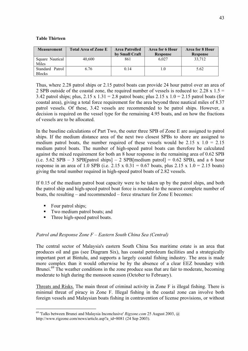
43
Table Thirteen Measurement Total Area of Zone E Area Patrolled
by Small Craft Area for 6 Hour
Response Area for 8 Hour
Response Square Nautical Miles
40,600 861 6,027 33,712
Standard Patrol Blocks
6.76 0.14 1.0 5.62
Thus, where 2.28 patrol ships or 2.15 patrol boats can provide 24 hour patrol over an area of 2 SPB outside of the coastal zone, the required number of vessels is reduced to: 2.28 x 1.5 = 3.42 patrol ships; plus, 2.15 x 1.31 = 2.8 patrol boats; plus 2.15 x 1.0 = 2.15 patrol boats (for coastal area), giving a total force requirement for the area beyond three nautical miles of 8.37 patrol vessels. Of these, 3.42 vessels are recommended to be patrol ships. However, a decision is required on the vessel type for the remaining 4.95 boats, and on how the fractions of vessels are to be allocated. In the baseline calculations of Part Two, the outer three SPB of Zone E are assigned to patrol ships. If the medium distance area of the next two closest SPBs to shore are assigned to medium patrol boats, the number required of these vessels would be 2.15 x 1.0 = 2.15 medium patrol boats. The number of high-speed patrol boats can therefore be calculated against the mixed requirement for both an 8 hour response in the remaining area of 0.62 SPB (i.e. 5.62 SPB – 3 SPB[patrol ships] – 2 SPB[medium patrol] = 0.62 SPB), and a 6 hour response in an area of 1.0 SPB (i.e. 2.15 x 0.31 = 0.67 boats, plus 2.15 x 1.0 = 2.15 boats) giving the total number required in high-speed patrol boats of 2.82 vessels. If 0.15 of the medium patrol boat capacity were to be taken up by the patrol ships, and both the patrol ship and high-speed patrol boat force is rounded to the nearest complete number of boats, the resulting – and recommended – force structure for Zone E becomes: Four patrol ships; Two medium patrol boats; and Three high-speed patrol boats.
Patrol and Response Zone F – Eastern South China Sea (Central) The central sector of Malaysia's eastern South China Sea maritime estate is an area that produces oil and gas (see Diagram Six), has coastal petroleum facilities and a strategically important port at Bintulu, and supports a largely coastal fishing industry. The area is made more complex than it would otherwise be by the absence of a clear EEZ boundary with Brunei.69 The weather conditions in the zone produce seas that are fair to moderate, becoming moderate to high during the monsoon season (October to February). Threats and Risks. The main threat of criminal activity in Zone F is illegal fishing. There is minimal threat of piracy in Zone F. Illegal fishing in the coastal zone can involve both foreign vessels and Malaysian boats fishing in contravention of license provisions, or without
69 'Talks between Brunei and Malaysia Inconclusive' Rigzone.com 25 August 2003, @ http://www.rigzone.com/news/article.asp?a_id=8081 (24 Sep 2003).

44
a license. Poaching of endangered species could occur in the zone. Illegal fishing further offshore is more likely to involve distant-water fishing vessels targeting pelagic stocks, such as tuna. The threat of smuggling and illegal immigration in the coastal zone is considered to be low. The threat of illegal fishing in the coastal zone is medium. The threat of illegal fishing beyond three nautical miles from shore is high. Based on Marine Department statistics and the expanse of the area concerned, the threat of navigational mishap causing pollution or injury would appear to be low. The threat of piracy or terrorist attack against offshore petroleum installations or port facilities is also considered to be low, but potentially would be of strategic significance if it were to occur. Force Structure Adjustments. Zone F is a large Patrol and Response Zone (22,500nm²). The outer boundary of Zone F is 250 nautical miles from shore.70 Therefore, the baseline vessel force developed in Part Two includes a requirement for patrol ships to operate in the outer-most 1.5 SPBs. However, in the context of threats and risks, the baseline force structure – 2.28 patrol ships, 2.58 medium patrol boats and 2.15 high-speed patrol boats – needs to be reviewed to account for local factors. Airborne surveillance would be based on a single sortie each day with maximum 'no see' time for any given point within Zone F of 21 hours. In the context of the identified threats and risks, this frequency of surveillance is adequate for areas beyond three nautical miles from shore. The use of land-based systems for surveillance in the coastal zone would improve coverage further. Therefore, from the perspective of surveillance, the contribution of airborne patrol and possible land-based surveillance removes any need for revision of the number of enforcement vessels determined in Part Two. The maximum time assumed for a vessel to respond to an enforcement or SAR contingency throughout the zone beyond three nautical miles from shore, is 8 hours. This requirement is exceeded by the normal response time of a single vessel in a SPB (5.8 hours). A response time of 8 hours would enable a single vessel to patrol two SPBs. Therefore, in order to determine the vessel requirements for Zone E, the total area in which an 8 hour response time will apply needs to be calculated: i.e. 3.75 SPB (total area of Zone F) – 0.05 SPB (area patrolled by small craft) = 3.7 SPB (see Table Fourteen). Table Fourteen
Measurement Total Area of Zone F Area Patrolled by Small Craft
Area for 8 Hour Response
Square Nautical Miles
22,500 315 22,185
Standard Patrol Blocks
3.75 0.05 3.7
Thus, where 2.28 patrol ships or 2.15 patrol boats can provide 24 hour patrol over an area of 2 SPB outside of the coastal zone, the required number of vessels is reduced to: 2.28 x 0.75 = 1.71 patrol ships; plus, 2.15 x 0.6 = 1.29 medium patrol boats; plus 2.15 x 0.5 = 1.07 high-speed patrol boats, giving a total force requirement for the area beyond three nautical miles of
70 See comment at Table Five.

45
4.07 patrol vessels. However, a decision is required on the vessel type for the boats, and on how the fractions of vessels are to be allocated. Given the maximum response time of 8 hours throughout the zone, and the potentially long distances over which the MMEA must patrol in Zone F, the recommendation is to move towards larger vessels in re-allocation of fractions of capability. Thus, if 0.29 medium patrol boat capability is passed to the patrol ship force, and the high-speed patrol boat capability is transferred to medium patrol boats, the resulting – and recommended – MMEA force structure for Zone F is: Two patrol ships; and Two medium patrol boats.
Patrol and Response Zone G – Eastern South China Sea (East) The eastern sector of Malaysia's eastern South China Sea maritime estate is an area that produces oil and gas (see Diagram Six), has coastal petroleum facilities, and supports a largely coastal fishing industry. Although there is some marine-based tourism, this industry is not as developed in Zone G as elsewhere in Malaysia. The weather conditions in the zone produce seas that are fair to moderate, becoming moderate to high during the monsoon season (October to February). Threats and Risks. The main threats of criminal activity in Zone G are coastal smuggling and illegal immigration from Philippines to the north, and illegal fishing. There is a threat of piracy in the northern part of the zone near Pulau Banggi; however, overall the piracy threat is low. Illegal fishing in the coastal zone can involve both foreign vessels and Malaysian boats fishing in contravention of license provisions, or without a license. Poaching of endangered species, and illegal, destructive fishing (cyanide and bombing) also occur in the zone.71 Illegal fishing further offshore is more likely to involve distant-water fishing vessels targeting pelagic stocks, such as tuna. The threat of smuggling, illegal immigration and illegal fishing in the coastal zone are all considered to be medium. The threat of illegal fishing beyond three nautical miles from shore is high. Based on Marine Department statistics and the expanse of the area concerned, the threat of navigational mishap causing pollution or injury would appear to be low. The threat of piracy or terrorist attack against offshore petroleum installations is also considered to be low, but potentially would be of strategic significance if it were to occur. Force Structure Adjustments. Zone G is also a large Patrol and Response Zone (22,000nm²). The outer boundary of Zone E is 195 nautical miles from shore, and the inner boundary is 18 nautical miles. Therefore, the baseline vessel force developed in Part Two includes a requirement for patrol ships to operate in the outer-most 1.5 SPBs. However, in the context of threats and risks, the baseline force structure – 2.28 patrol ships, 2.21 medium patrol boats and 2.15 high-speed patrol boats – needs to be reviewed to account for local factors. Airborne surveillance would be based on a single sortie each day with maximum 'no see' time for any given point within Zone G of 21 hours. In the context of the identified threats and
71 'Kota Kinabalu: 1,000kg bombed fish seized' Daily Express. Wednesday, 15 March 2000.

46
risks, this frequency of surveillance is adequate for areas beyond three nautical miles from shore. The use of land-based systems for surveillance in the coastal zone would improve coverage further. Therefore, from the perspective of surveillance, the contribution of airborne patrol and possible land-based surveillance removes any need for revision of the number of enforcement vessels determined in Part Two. In the relevant part of the Zone G coastal area – i.e. beyond three nautical miles and up to 24 nautical miles from the shoreline – the maximum time assumed for vessel response to an enforcement or SAR contingency is 6 hours. This requirement is met by the normal response time of a single vessel in a SPB (5.8 hours). The maximum time assumed for vessel response beyond 24 nautical miles is 8 hours. As discussed for other zones, a response time of 8 hours would enable a single vessel to patrol two SPBs. Therefore, in order to determine the vessel requirements for Zone G, the total area in which an 8 hour response time will apply needs to be calculated: i.e. 3.66 SPB (total area of Zone G) – 0.13 SPB (area patrolled by small craft) – 0.93 SPB (area between 3nm and 24nm of the coastal zone) = 2.6 SPB (see Table Fifteen). Table Fifteen Measurement Total Area of Zone G Area Patrolled
by Small Craft Area for 6 Hour
Response Area for 8 Hour
Response Square Nautical Miles
22,000 795 5,565 15,640
Standard Patrol Blocks
3.66 0.13 0.93 2.6
Thus, where 2.28 patrol ships or 2.15 patrol boats can provide 24 hour patrol over an area of 2 SPB outside of the coastal zone, the required number of vessels is reduced to: 2.28 x 0.75 = 1.71 patrol ships; plus, 2.15 x 0.55 = 1.18 patrol boats; plus 2.15 x 0.93 = 1.99 patrol boats (for coastal area), giving a total force requirement for the area beyond three nautical miles of 4.88 patrol vessels. Of these, 1.71 vessels are recommended to be patrol ships. However, a decision is required on the vessel type for the remaining 3.17 boats, and on how the fractions of vessels are to be allocated. In the baseline calculations of Part Two, the outer-most 1.5 SPB of Zone G are assigned to patrol ships. If the medium distance area of the next closest SPB to shore is assigned to medium patrol boats, the number required of these vessels would be 2.15 x 0.5 = 1.07 medium patrol boats. Therefore, the number of high-speed patrol boats can be calculated against a mixed requirement for both an 8 hour response in the remaining area of 0.1 SPB (2.15 x 0.05 = 0.1 vessels) and a 6 hour response in an area of 0.93 SPB giving a total requirement for 2.1 high-speed patrol boats. If 0.29 of the medium patrol boat capacity were to be taken up by the patrol ships, there would be a requirement for two patrol ships and a reduced requirement for 0.78 medium patrol boats. If 0.1 of the high-speed capacity is transferred to the medium patrol boat force, the resulting – and recommended – structure becomes: Two patrol ships; One medium patrol boat; and Two high-speed patrol boats.

47
Patrol and Response Zone H – Sulu Sea The Sulu Sea is a narrow band of ocean with a jaggered, complicated coastline of indentations and small islands. The maximum distance of the outer boundary of the zone is 36 nautical miles, and the minimum distance is only 7 nautical miles. Much of the Sabah coast in this zone is lined with mangroves. The Sulu Sea is an alternative route for north-south bound international shipping. The area also supports a coastal fishing industry. The weather conditions in Zone H produce light to moderate seas. Threats and Risks. Unfortunately, the Sulu Sea is rather notorious as an area prone to piracy and smuggling.72 Recently, concerns have been raised that the area is also a potential entry point for terrorists. 73 There is extensive illegal fishing, environmentally harmful fishing, and poaching in the area by Malaysian and foreign vessels.74 Fast boats carrying illegal immigrants do not take long to cross the short distance over the Sulu Sea, and many illegal immigrants enter Sabah in this way.75 The threat of piracy, smuggling, illegal immigration and illegal fishing in the coastal zone are all very high. The threat of terrorist activity in the area is high. Given the narrowness of certain navigation channels in the Sulu Sea, the threat of navigational mishap leading to injury or environmental harm is medium. Force Structure Adjustments. Zone H is a small Patrol and Response Zone (1,800nm²) but it has a long coastline (260nm). Therefore, given the narrowness of the zone, only high-speed patrol boats are identified to work with small intercept and pursuit craft in this area. However, in the context of threats and risks, the baseline force structure – 0.36 high-speed patrol boats – needs to be reviewed to account for local factors. A total of two airborne surveillance sorties are assumed to take place in Zone H each day. Two sorties per day would give a maximum 'no see' time for any given point within the zone of 9 hours, which is considered adequate for the area beyond three nautical miles from shore. As in Zones A and B, the frequency of near-shore patrol by small craft is expected to be intensive within the three nautical mile area. Also consistently with Zones A and B, the contribution of shore-based surveillance systems would further reduce 'no see' time within the coastal zone. Therefore, the surveillance requirements of Zone H do not necessitate any change in the vessel numbers determined in Part Two.
72 ‘Sulu Sea sees pirate hostage takers’ 15 June 2001, CNN.com/ WORLD @ http://edition.cnn.com/2001/WORLD/asiapcf/southeast/06/15/malaysia.kidnap. 73 "Security forces said there had been four attempts by terrorists from neighbouring Philippines to sneak into Malaysia's eastern Sabah state, including one possible try by Jemaah Islamiyah bomb-maker Fathur Rohman al-Ghozi. Muhamad Yasin Yahya, fifth brigade commander, said, however, that all the attempted incursions were prevented due to the increased presence of security forces and their constant patrol of the eastern coastal waters of Sabah on Borneo coast. We admit having heard of many attempts by terrorist groups to enter the country via the Sulu Sea and Sandakan but they failed because of tight Malaysian security, Muhamad Yassin said." 'Attempts by terrorists in Philippines to enter Sabah foiled' Malaysia Kini. 24 August 2003 @ http://www.malaysiakini.com/news/2003082400111839.php 74 For example, see '14 Malaysians held, trawlers seized for alleged poaching in Philippines' New Straits Times. Saturday 06 September 2003. p. B19. 75 Sutarji, op. cit., p. 14.

48
Throughout Zone H, the maximum time assumed for vessel response to an enforcement or SAR contingency is 1 hour.76 The vessel numbers determined for Zone H in Part Two were based upon a maximum response time of 5.8 hours for a single vessel patrolling one SPB. Rather than increase the number of expensive, high-speed patrol boats deployed in Zone H, the study assumes that smaller intercept and pursuit craft (< 25m length) will be used to provide first response throughout the zone. Because the Sulu Sea becomes very narrow in the western portion of the zone, follow-up response by a larger, high-speed patrol boat would probably only be necessary or practical in the eastern part of Zone H, and in most cases this would occur well within 4 hours (i.e. 80nm @ 20kts). Therefore, in order to provide almost 365 days high-speed patrol boat presence in Zone H, the recommended MMEA structure is for two of these vessels. Patrol and Response Zone I – Sulawesi Sea The Sulawesi Sea has vast areas of fringing coral reefs, sea grass, mangroves, and estuaries. Several marine-based tourism resorts – focused on diving – have been established on islands in the area. The Sulawesi Sea has a rich diversity of aquatic ecosystems and marine life. In general, most fishing is concentrated in the coastal waters within 30 nautical miles from the coast. The pelagic fish stocks of Zone H (relevant especially for EEZ fishing) are migratory in nature, and are targeted also by the fishermen of neighbouring countries.77 The weather conditions in the zone produce seas that are generally light to moderate, and occasionally high. Threats and Risks. The main threats of criminal activity in Zone I are piracy, coastal smuggling and illegal immigration from Indonesia and Philippines, and illegal fishing. 78 One of Malaysia’s highest profile incidents of terrorism also occurred at Sipadan Island in Zone I. Rebel groups still operate in southern Philippines and there remains a possibility that their activities will once again impact upon the Malaysian maritime estate in the area. The threat of piracy, smuggling, illegal immigration and illegal fishing in the coastal zone is very high. The threat of terrorism in the coastal zone is high. The threat of piracy and illegal fishing beyond the coastal zone is also considered to be high. Notably, there are many fishing vessels targeting the same fish stocks in the area and this may cause a potential for conflict. The threat of navigational mishap leading to casualty or environmental damage in the zone is medium. Force Structure Adjustments. Zone I is a moderately sized zone (8,300nm²). The outer boundary of the zone is 134 nautical miles from the coastline, and the inner boundary is only 9 nautical miles. In the context of threats and risks, the baseline force structure – 1.07 medium patrol boats and 1.65 high-speed patrol boats – needs to be reviewed to account for local factors.
76 A vessel traveling at 20kts would take one hour to cross 20nm from one side of the Straits to the other. Although some vessels are capable of higher speeds than this, and the distance is frequently shorter, one hour is considered to be the fastest practicable target response time. 77 Sabah Information Booklet. Chapter 6 ‘ Natural Resources’ Sabah Department of Town Planning. @ http://www.townplanning.sabah.gov.my/iczm/Reports/Spatial%20Plan/mst-NATURAL.html (06 Sep 2003). 78 'Kota Kinabalu: Anti-smuggling ops with Indons' Daily Express. 09 June 2001.

49
A total of two airborne surveillance sorties are assumed to take place in Zone I each day. Two sorties per day would give a maximum 'no see' time for any given point within the zone of 9 hours, which is considered adequate for the area beyond three nautical miles from shore. As in Zones A, B, and H the frequency of near-shore patrol by small craft is expected to be intensive within the three nautical mile area. Also consistently with Zones A, B, and H the contribution of shore-based surveillance systems would further reduce 'no see' time within the coastal zone. Therefore, the surveillance requirements of Zone I do not necessitate any change in the vessel numbers determined in Part Two. In the Zone I coastal area – i.e. up to 24 nautical miles from the shoreline – the maximum time assumed for vessel response to an enforcement or SAR contingency is 1 hour. Rather than increase the number of high-speed patrol boats deployed in Zone I, the study assumes that smaller intercept and pursuit craft (< 25m length) will be used to provide first response throughout the coastal zone. Follow-up response by a larger, high-speed patrol boat would probably occur in most cases well within 4 hours (i.e. 80nm @ 20kts). The maximum time assumed for vessel response beyond 24 nautical miles is 6 hours. This requirement is met by the normal response time of a single vessel in a SPB (5.8 hours). Table Sixteen
Measurement Total Area of Zone I Area Patrolled by Small Craft
Area for 1 Hour Response
Area for 6 Hour Response
Square Nautical Miles
8,300 675 4,725 2,900
Standard Patrol Blocks
1.38 0.11 0.78 0.49
Therefore, in order to provide almost 365 days high-speed patrol boat presence in Zone I, the recommended MMEA structure essentially remains as calculated in the baseline force shown at Table Seven (with 1.65 high-speed patrol boats rounded up to a total of two vessels) at: One medium patrol boat; and Two high-speed patrol boats.
Summary A systematic examination of the threats and risks in each Patrol and Response Zone, along with consideration of the natural resources and uses of the Malaysian maritime estate, enables the baseline force structure of 45.39 vessels, developed in Part Two, to be refined giving a total enforcement fleet strength of 37 vessels. The reduction in the total number of required vessels reflects an increase in allowable maximum response time in various parts of the maritime estate. In general, this study shows that the number of enforcement vessels needed is determined essentially by the required response time. The balance between response time and vessel numbers is expected to be an important consideration in cost/benefit calculations for future MMEA acquisition programs. At present, the Malaysian Marine Department operates four ‘Bintang Class’ 26m patrol vessels. As discussed in Part One ‘Assumptions’, these vessels are discounted against the new fleet requirement in this essay with a negative weighting factor of 0.5 per boat.

50
Therefore, the continued operation of four Bintang Class patrol boats reduces the number of new high-speed patrol boats that are needed by two units. For the purpose of depiction only, the Bintang vessels are allocated to Zone D in this essay (See Table Eighteen). A breakdown of the number of vessels of each type is shown at Table Seventeen. A summary of vessel allocation per Patrol and Response Zone is shown at Table Eighteen.
Table Seventeen: SUMMARY OF VESSELS BY TYPE
Vessel Type Number Patrol ships 10 Medium Boats 10 High-speed Patrol Boats 15 Bintang Class 4
Table Eighteen: SUMMARY OF VESSELS PER ZONE
Zone Vessel Type Number A Medium Patrol
High-speed Patrol 2 2
B High-speed Patrol 2 C Patrol Ships
Medium Patrol High-speed Patrol
2 2 2
D Bintang Class 4 E Patrol Ships
Medium High-speed Patrol
4 2 3
F Patrol Ships Medium
2 2
G Patrol Ships Medium High-speed Patrol
2 1 2
H High-speed Patrol 2 I Medium Patrol
High-speed Patrol 1 2

51
MMEA FORCE STRUCTURE CONCLUSION

52
Conclusion The MMEA will assume responsibility for enforcement and SAR throughout a vast maritime estate. In some places, geography demands that vessels be capable of sustained operations far out to sea. In others, vessels are required to be nimble and fast. Maritime threats, risks, resources and uses vary considerably throughout the territorial sea, contiguous zone, EEZ and continental shelf. However, as Malaysia moves towards the target of becoming a fully developed country by 2020, every effort must be made to ensure that resources are not wasted. With regard to the MMEA, there are two potential pitfalls to be avoided in developing a modern maritime enforcement fleet. The first, would be to spend more funds than necessary on building capacity that was either not needed or inefficiently applied. The second, would be to make false savings by holding back on the true level of force development needed for the MMEA to achieve its mission. The Malaysian maritime estate contributes billions each year, both directly and indirectly, to the national economy. Such a vital resource must be protected and managed properly, and effective enforcement is crucial to that task. This paper argues that force development planning needs to be done systematically and transparently. A model for force structure planning has been established and a suite of assumptions articulated so that the process is able to be demonstrated. Effort is made to ensure that the assumptions are realistic and achievable. To this extent, the resultant fleet requirements are indicative of the true needs of a modern, well-equipped MMEA. Based on the given assumptions, the essay concludes that the MMEA ideally should be equipped with a fleet of 39 vessels consisting of: 10 patrol ships (helicopter capable) (80-85m length); 10 medium patrol boats (55-60m length); 15 high-speed patrol boats (35kt, 35-40m length); and 4 existing ‘Bintang Class’ patrol boats.