Embed Size (px)
Citation preview
Vessel Transits through Olympic Coast National Marine Sanctuary
and Area to be Avoided – 2020 Estimated Compliance
Introduction
Designated in 1994, Olympic Coast National Marine Sanctuary (OCNMS) is a place of regional,
national, and global significance. OCNMS is connected to both the Juan de Fuca Eddy
Ecosystem and the California Current Large Marine Ecosystem, and is the site of one of North
America’s most productive marine
regions and is bounded landward by
spectacular, undeveloped shorelines.
Potential releases of oil or other
hazardous material from a major
marine accident, in combination with
climate change and ocean
acidification, pose serious threats to
the health and quality of sanctuary
resources. Prevention of spills is
therefore one of OCNMS’s highest
priorities. As a steward of these vitally
important natural resources, OCNMS
will continue to collaborate with other
governments, agencies, and user
groups to reduce the potential for oil
spills and improve contingency
planning for spill response. OCNMS’s
major oil spill prevention initiative is
an International Maritime
Organization (IMO) designated Area
to be Avoided (ATBA). This report is
the sanctuary’s annual reporting of
estimated ATBA compliance rates.
Data from Automatic Identification
System (AIS) transceivers is collected,
vessel details are added, and
compliance to the ATBA is evaluated.
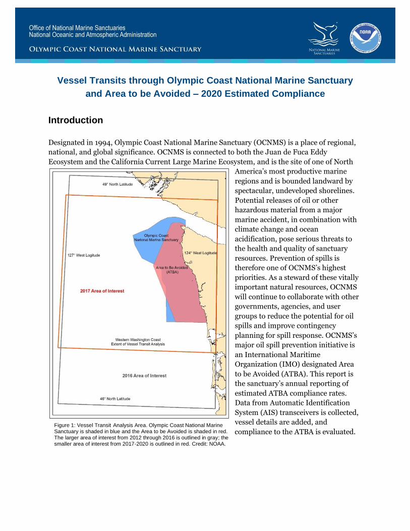
Figure 1: Vessel Transit Analysis Area. Olympic Coast National Marine Sanctuary is shaded in blue and the Area to be Avoided is shaded in red. The larger area of interest from 2012 through 2016 is outlined in gray; the smaller area of interest from 2017-2020 is outlined in red. Credit: NOAA.
Vessel Transits Through Olympic Coast National Marine Sanctuary March 2021 and Area to Be Avoided (ATBA) - 2020 Estimated Compliance
2
Our evaluation of the 2020 vessel transits off the Washington coast shows a compliance rate
consistent with the previous 3 years: 95.9% in 2017, 95.0% in 2018, 95.5% in 2019, and 94.9% in
2020.
Background
During the sanctuary designation process, NOAA worked with the U.S. delegation to the IMO to
designate an Area to be Avoided (ATBA) off the coast of Washington to reduce the risk of marine
casualties including oil spills and potential environmental damage to Olympic Coast National
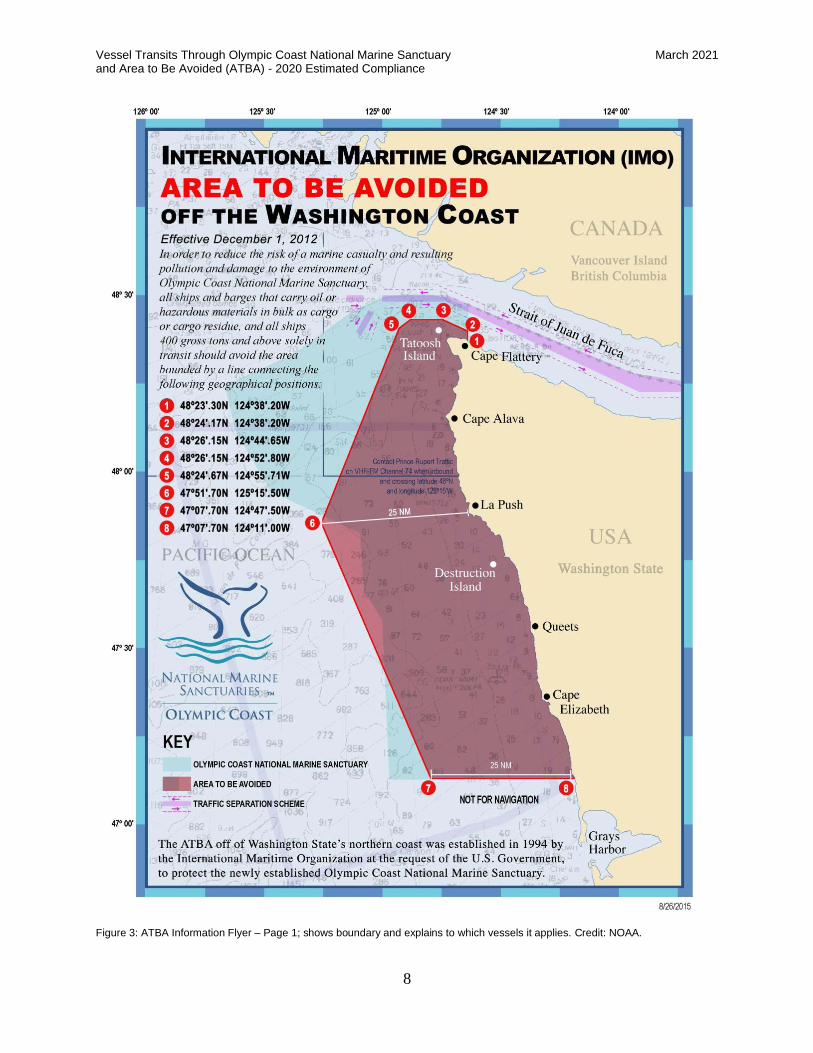
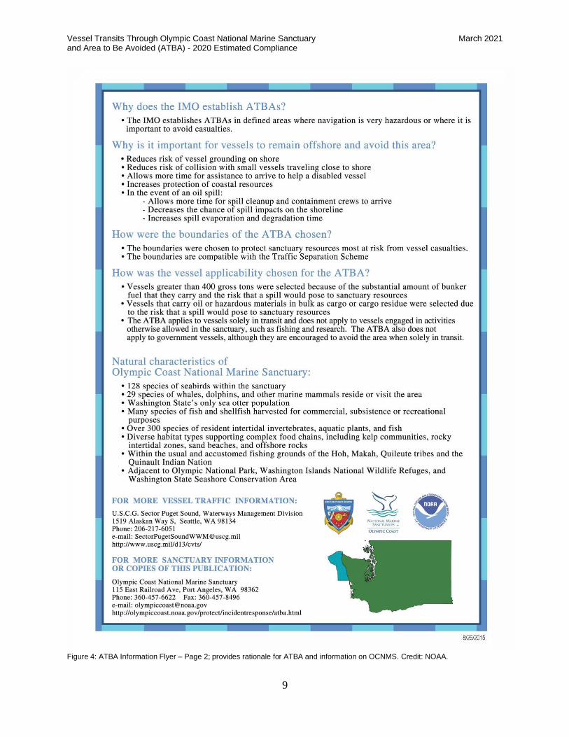
Marine Sanctuary. For more information on the ATBA see the attached informational flyer
(Figure 3 and Figure 4). This flyer is used in outreach efforts to the marine industry, and is also
included in the U.S. Coast Guard Sector Puget Sound Vessel Traffic Service’s (VTS) User’s
Manual. In addition, ATBA boundaries and provisions are included in official navigational
products, such as nautical charts and Coast Pilot 10.
ATBA Provisions
All ships and barges that carry oil or hazardous materials as cargo, and all ships 400 gross tons
and above, solely in transit, are advised to transit outside of this ATBA. OCNMS, in cooperation
with the U.S. and Canadian coast guards, monitors vessel compliance under this voluntary
program. While the ATBA does not apply to government vessels, the sanctuary, in partnership
with the U.S. and Canadian coast guards, seeks to ensure that government vessels comply when
in transit. This includes NOAA, U.S. and Canadian Coast Guard vessels, and the U.S. Navy.
It is important to understand the implications of the ATBA provision “solely in transit.” The
ATBA was not intended to preclude lawful operations of vessels within the ATBA. Examples
include fishing, search and rescue, and research vessels that may conduct operations off
Washington’s outer coast. When these vessels are moving through the area en route to working
grounds beyond the ATBA, or solely in transit, we request their compliance with the ATBA.
While we recognize that there are vessels over 400 gross tons that are legitimately conducting
operations in the ATBA, we do not attempt to adjust the estimated compliance numbers to
account for this. For that reason some vessel types, such as fishing and research vessels, will
likely show an artificially lower compliance rate because all of their occurrences in the ATBA are
counted as non-compliance. The reason for this approach is the difficulty of determining the
nature of some transits. In some cases, it is fairly obvious from the vessel track line that a
research or fishing vessel is conducting operations, in other cases it is not as obvious. Due to this
difficulty, and in order to be consistent from one year to the next, OCNMS does not make
adjustments to the compliance estimates for individual vessel transits based on perceived
operations.
Vessel Transits Through Olympic Coast National Marine Sanctuary March 2021 and Area to Be Avoided (ATBA) - 2020 Estimated Compliance
3
ATBA Compliance Reporting
From 2004 through 2011, the Washington State Department of Ecology (Ecology) published
estimated ATBA compliance rates as part of their annual Vessel Entries and Transits (VEAT)
publication. VEAT is offered by Ecology in response to public requests for information about
commercial vessel traffic in Washington waters. There is considerable overlap between the
VEAT report and OCNMS’ vessel monitoring efforts and the reason why the two reports were
once coordinated. When OCNMS made significant changes to their monitoring methods,
additional documentation was needed. This led to the need, starting in 2012, for an independent
OCNMS report. Both the VEAT (2004-2011) and OCNMS (2012-2020) reports can be
downloaded at the Vessel Traffic Monitoring site.
Discussion of Data
In 2017, in response to a loss of OCNMS technical capacity and the need to make our vessel
traffic monitoring more sustainable, a number of changes were instituted. These three changes
were: the source of Automatic Identification System (AIS) data, the source of third party vessel
attributes, and the area analyzed. The first two changes were made to become more consistent
with the NOAA Fisheries Office of Protected Resources (OPR), which has well-established AIS
processing techniques currently in use for a variety of conservation applications involving vessel
traffic. By collaborating with OPR, OCNMS is able to maintain vessel monitoring at a reduced
staffing level. The 2020 data was processed in the same manner as 2017 through 2019, allowing
comparison between those years. There is additional detail on our new methodology and data
sources in the 2017 report.
The AIS system is primarily a collision avoidance system and does not have all of the
information needed for monitoring vessel traffic and estimating ATBA compliance in the
sanctuary, e.g., descriptive vessel types and gross tonnage. This information is obtained from the
IHS Maritime and Trade’s (IHS) World Register of Ships. Relevant IHS vessel attributes are
joined to the AIS transit data using the vessel’s Maritime Mobile Service Identity (MMSI)
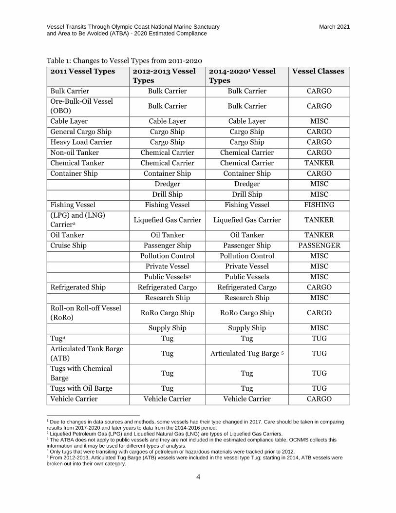
number as a common key. The 320 different possible vessel types found in the IHS dataset were
aggregated into vessel type classes consistent with previous vessel type descriptions. To simplify
analysis and visual display of data, similar vessel types are grouped into one of six more general
vessel classes (see Vessel Classes column in Table 1).
For the analysis of AIS data between 2012 and 2016, we reviewed transits from 46° to 49° north
latitude and from 124° to 127° west longitude. This 29,099 square mile area covered the entire
outer coast of Washington state (see Figure 1) and was selected to support the marine spatial
planning efforts of the state of Washington. Starting in 2017, a smaller 19,692 square mile area
was selected. The new area is from approximately 46°45’ N to 48°45’ N and maintains the same
east and west boundaries (see Figure 1). This change reduces the number of vessels that needed
to be researched.
Vessel Transits Through Olympic Coast National Marine Sanctuary March 2021 and Area to Be Avoided (ATBA) - 2020 Estimated Compliance
4
Table 1: Changes to Vessel Types from 2011-2020
2011 Vessel Types 2012-2013 Vessel
Types
2014-20201 Vessel
Types
Vessel Classes
Bulk Carrier Bulk Carrier Bulk Carrier CARGO
Ore-Bulk-Oil Vessel
(OBO) Bulk Carrier Bulk Carrier CARGO
Cable Layer Cable Layer Cable Layer MISC
General Cargo Ship Cargo Ship Cargo Ship CARGO
Heavy Load Carrier Cargo Ship Cargo Ship CARGO
Non-oil Tanker Chemical Carrier Chemical Carrier CARGO
Chemical Tanker Chemical Carrier Chemical Carrier TANKER
Container Ship Container Ship Container Ship CARGO
Dredger Dredger MISC
Drill Ship Drill Ship MISC
Fishing Vessel Fishing Vessel Fishing Vessel FISHING
(LPG) and (LNG)
Carrier2 Liquefied Gas Carrier Liquefied Gas Carrier TANKER
Oil Tanker Oil Tanker Oil Tanker TANKER
Cruise Ship Passenger Ship Passenger Ship PASSENGER
Pollution Control Pollution Control MISC
Private Vessel Private Vessel MISC
Public Vessels3 Public Vessels MISC
Refrigerated Ship Refrigerated Cargo Refrigerated Cargo CARGO
Research Ship Research Ship MISC
Roll-on Roll-off Vessel
(RoRo) RoRo Cargo Ship RoRo Cargo Ship CARGO
Supply Ship Supply Ship MISC
Tug4 Tug Tug TUG
Articulated Tank Barge
(ATB) Tug Articulated Tug Barge 5 TUG
Tugs with Chemical
Barge Tug Tug TUG
Tugs with Oil Barge Tug Tug TUG
Vehicle Carrier Vehicle Carrier Vehicle Carrier CARGO
1 Due to changes in data sources and methods, some vessels had their type changed in 2017. Care should be taken in comparing results from 2017-2020 and later years to data from the 2014-2016 period. 2 Liquefied Petroleum Gas (LPG) and Liquefied Natural Gas (LNG) are types of Liquefied Gas Carriers. 3 The ATBA does not apply to public vessels and they are not included in the estimated compliance table. OCNMS collects this information and it may be used for different types of analysis. 4 Only tugs that were transiting with cargoes of petroleum or hazardous materials were tracked prior to 2012. 5 From 2012-2013, Articulated Tug Barge (ATB) vessels were included in the vessel type Tug; starting in 2014, ATB vessels were broken out into their own category.
Vessel Transits Through Olympic Coast National Marine Sanctuary March 2021 and Area to Be Avoided (ATBA) - 2020 Estimated Compliance
5
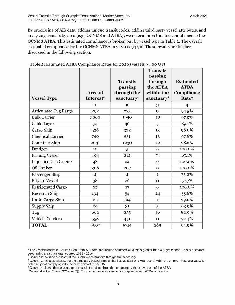
By processing of AIS data, adding unique transit codes, adding third party vessel attributes, and
analyzing transits by area (e.g., OCNMS and ATBA), we determine estimated compliance to the
OCNMS ATBA. This estimated compliance is broken out by vessel type in Table 2. The overall
estimated compliance for the OCNMS ATBA in 2020 is 94.9%. These results are further
discussed in the following section.
Table 2: Estimated ATBA Compliance Rates for 2020 (vessels > 400 GT)
Vessel Type
Area of
Interest6
Transits
passing
through the
sanctuary7
Transits
passing
through
the ATBA
within the
sanctuary8
Estimated
ATBA
Compliance
Rate9
1 2 3 4
Articulated Tug Barge 292 275 15 94.5%
Bulk Carrier 3802 1940 48 97.5%
Cable Layer 74 46 5 89.1%
Cargo Ship 538 322 13 96.0%
Chemical Carrier 740 531 13 97.6%
Container Ship 2031 1230 22 98.2%
Dredger 10 5 0 100.0%
Fishing Vessel 404 212 74 65.1%
Liquefied Gas Carrier 48 24 0 100.0%
Oil Tanker 306 207 0 100.0%
Passenger Ship 4 4 1 75.0%
Private Vessel 38 26 11 57.7%
Refrigerated Cargo 27 17 0 100.0%
Research Ship 134 54 24 55.6%
RoRo Cargo Ship 171 104 1 99.0%
Supply Ship 68 31 5 83.9%
Tug 662 255 46 82.0%
Vehicle Carriers 558 431 11 97.4%
TOTAL 9907 5714 289 94.9%
6 The vessel transits in Column 1 are from AIS data and include commercial vessels greater than 400 gross tons. This is a smaller geographic area than was reported 2012 - 2016. 7 Column 2 includes a subset of the S-AIS vessel transits through the sanctuary. 8 Column 3 includes a subset of the sanctuary vessel transits that had at least one AIS record within the ATBA. These are vessels potentially not complying with the provisions of the ATBA. 9 Column 4 shows the percentage of vessels transiting through the sanctuary that stayed out of the ATBA. {Column 4 = 1 – (Column3/Column2)}. This is used as an estimate of compliance with ATBA provisions.
Vessel Transits Through Olympic Coast National Marine Sanctuary March 2021 and Area to Be Avoided (ATBA) - 2020 Estimated Compliance
6
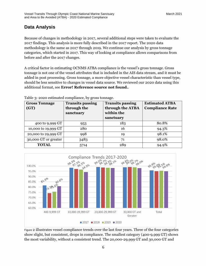
Data Analysis
Because of changes in methodology in 2017, several additional steps were taken to evaluate the
2017 findings. This analysis is more fully described in the 2017 report. The 2020 data
methodology is the same as 2017 through 2019. We continue our analysis by gross tonnage
categories, which started in 2017. This way of looking at compliance allows comparisons from
before and after the 2017 changes.
A critical factor in estimating OCNMS ATBA compliance is the vessel’s gross tonnage. Gross
tonnage is not one of the vessel attributes that is included in the AIS data stream, and it must be
added in post processing. Gross tonnage, a more objective vessel characteristic than vessel type,
should be less sensitive to changes in vessel data source. We reviewed our 2020 data using this
additional format, see Error! Reference source not found..
Table 3: 2020 estimated compliance, by gross tonnage.
Gross Tonnage
(GT)
Transits passing
through the
sanctuary
Transits passing
through the ATBA
within the
sanctuary
Estimated ATBA
Compliance Rate
400 to 9,999 GT 953 183 80.8%
10,000 to 19,999 GT 280 16 94.3%
20,000 to 29,999 GT 998 19 98.1%
30,000 GT or greater 3483 71 98.0%
TOTAL 5714 289 94.9%
Figure 2 illustrates vessel compliance trends over the last four years. Three of the four categories
show slight, but consistent, drops in compliance. The smallest category (400-9,999 GT) shows
the most variability, without a consistent trend. The 20,000-29,999 GT and 30,000 GT and
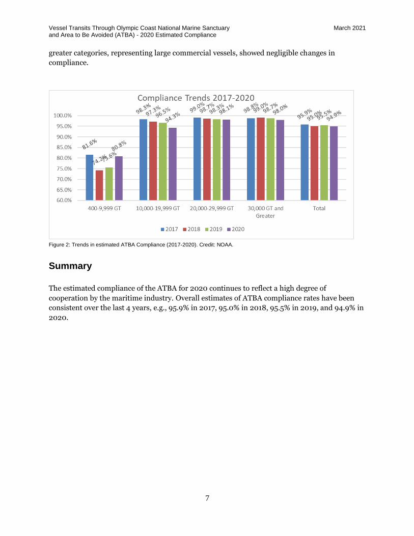
Vessel Transits Through Olympic Coast National Marine Sanctuary March 2021 and Area to Be Avoided (ATBA) - 2020 Estimated Compliance
7
greater categories, representing large commercial vessels, showed negligible changes in
compliance.
Figure 2: Trends in estimated ATBA Compliance (2017-2020). Credit: NOAA.
Summary
The estimated compliance of the ATBA for 2020 continues to reflect a high degree of
cooperation by the maritime industry. Overall estimates of ATBA compliance rates have been
consistent over the last 4 years, e.g., 95.9% in 2017, 95.0% in 2018, 95.5% in 2019, and 94.9% in
2020.
Vessel Transits Through Olympic Coast National Marine Sanctuary March 2021 and Area to Be Avoided (ATBA) - 2020 Estimated Compliance
8
Figure 3: ATBA Information Flyer – Page 1; shows boundary and explains to which vessels it applies. Credit: NOAA.
Vessel Transits Through Olympic Coast National Marine Sanctuary March 2021 and Area to Be Avoided (ATBA) - 2020 Estimated Compliance
9
Figure 4: ATBA Information Flyer – Page 2; provides rationale for ATBA and information on OCNMS. Credit: NOAA.