Embed Size (px)
DESCRIPTION
Reporte estructural sobre las zonas mineralizadas del distrito minero de vetas (Santander)
Citation preview

Tectonic Setting and Structural Controlsof the
Vetas Gold System
June 2012

CAUTION REGARDING FORWARD LOOKING STATEMENTS:
Certain statements included in this presentation are forward-looking statements within the meaning of Canadian securities laws,including the following statements regarding the properties in the Departamento de Norte de Santander and the Departamento deSantander: the ability of CB Gold Inc. (the “Company”) to acquire concessions with potential resources; the potential to developresources and then further develop reserves; the anticipated economic potential of the concessions; the anticipated economic andpolitical developments in Colombia; the availability of capital to finance the Company to execute its Company Strategy.
Forward-looking statements are based on estimates and assumptions made by the Company in light of its experience andperception of historical trends, current conditions and expected future developments, as well as other factors that the concessions’holder believes are appropriate in the circumstances. Many factors could cause the Company’s results, performance orachievements to differ materially from those expressed or implied by the forward looking statements, including: discrepanciesbetween actual and estimated resources; exploration, development and operating risks; limited experience with development-stagemining operations; dependence on early exploration stage concessions; political and foreign risks; uninsurable risks; competition;production risks; regulatory restrictions, including environmental regulatory restrictions and liability; currency fluctuations; defectivetitle to mineral claims or property and dependence on key employees. Persons reviewing this presentation are cautioned not toplace undue reliance on forward-looking statements due to inherent uncertainty therein. The Company disclaims any intention orobligation to update or revise any forward-looking statements, whether as a result of new information, future events or otherwise,except as required by law.
The scientific and technical information on which this presentation has been based was approved by Christopher Lee, PrincipalGeologist at Touchstone Geoscience Inc. and a Qualified Person as defined by National Instrument 43-101 – Standards ofDisclosure for Mineral Projects.
Safe Harbor
2

CAUTIONARY NOTE TO UNITED STATES INVESTORS:
The securities of the Company referred to herein have not been and will not be registered under the U.S. Securities Act of1933 (the "U.S. Securities Act"), as amended, and may only be offered, and this presentation may only be made, topersons within the United States or to, or for the account or benefit of, U.S. persons (as that term is defined in Regulation Sunder the U.S. Securities Act) that are "accredited investors" within the meaning of Rule 501(a) of Regulation D under theU.S. Securities Act.
CAUTIONARY NOTE REGARDING FORWARD-LOOKING STATEMENTS:
Forward-looking statements in this presentation are made pursuant to the "safe harbor" provisions of the U.S. PrivateSecurities Litigation Reform Act of 1995 and Canadian securities laws. The words "expect", "anticipate", "estimate","may", "will", "should", "intend", "believe", "continue"," and similar expressions are intended to identify forward-lookingstatements. Forward-looking statements are based on estimates and assumptions made by the Company in light of itsexperience and its perception of historical trends, current conditions and expected future developments, as well as otherfactors that the Company believes are appropriate in the circumstances. Many factors could cause the Company’s results,performance or achievements to differ materially from those expressed or implied by the forward looking statements,including: discrepancies between actual and estimated resources; exploration, development and operating risks; limitedexperience with development-stage mining operations; dependence on early exploration stage concessions; political andforeign risks; uninsurable risks; competition; production risks; regulatory restrictions, including environmental regulatoryrestrictions and liability; currency fluctuations; defective title to mineral claims or property and dependence on keyemployees. These factors should be considered carefully, and investors should not place undue reliance on the Company'sforward-looking statements. The Company has no intention and undertakes no obligation to update or revise any forward-looking statements, whether as a result of new information, future events or otherwise, except as required by law.
US Disclaimer
3

4
Location
• Vetas area forms part of an historic gold mining district that dates back to the 16th
century, located in the Eastern Cordillera of the Colombian Andes
• Located in the District of Santander, approximately ~100 km by road northeast of Bucaramanga
• Topography in the area ranges from 2,900 to 4,200 metres above sea level; with veins exposed over full range
• Gold is found in a variety of vein types ranging from high grade, fault-hosted veins, to more widespread stockwork and sheeted veins

5
Tectonic Setting
Vetas
The Vetas district forms part of the ‘Santander Massif’ – the uplifted and remobilized western margin of the Precambrian Guyana Shield.
The Santander Massif is being exhumed as part of the Maracaibo Block - a wedge of continental crust that is being extruded northward in response to plate convergence and subduction along the Caribbean and Pacific margins.
The complex structural, hydrothermal and magmatic evolution of this dynamic environment has given rise to the prolific gold veins of the Vetas mining district.
A A’
BFZ BFZ
BFZ: Bucaramanga Fault Zone
Santander Massif

6
Tectonic Setting
Bucaramanga Fault Zone
A A’
The Bucaramanga Fault Zone (BFZ) is a deep, crustal scale structure that forms the western boundary of the Santander Massif. It has accommodated somewhere between 40 and 100 kilometres of left-lateral displacement, during the northward extrusion of the Maracaibo Block. Exhumation of remobilized slivers of the Guiana Shield in the footwall of the BFZ has brought the rocks of the Santander Massif to surface, where they form the host rocks to the Vetas gold veins.
Seismic studies indicate that the BFZ is currently tapping deep crustal and/or upper mantle-derived magmas and it has likely done so since the Pliocene (2.5-5.0 million years ago). The BFZ is considered to be a 1st order control on the collection and delivery of gold-bearing magmas and fluids to the Vetas district. Understanding its timing and kinematics is therefore a critical component to the successful target delineation and predictability of the Vetas gold system.
EastWest
Santander Massif

Structural Geology
Vetas
California
The Vetas region is underlain by a mixture of Precambrian gneisses of the Santander Massif, along with deformed and metamorphosed Paleozoic supracrustal and intrusive rocks.
The region is bounded to the west by the long-lived, crustal scale Bucaramanga Fault zone, and by a less fundamental but significant structure referred to as the Socota and/or Santander Fault, which may be a secondary splay off the Bucaramanga Fault at depth. The wedge formed between these two major faults is further dissected by tertiary, NE-trending structures, which also tend to define locally distinct lithological breaks.
The Bucaramanga-Santander fault zone was also the locus of voluminous Triassic-Jurassic magmatism, attesting to its long-lived, fundamental structural control in this region.
Carboniferous - Permian
Proterozoic(Santander Massif)
Ordovician - Silurian
Triassic - Jurassic
Granitic and tonalitic orthogneiss, with amphibolitic paragneiss and migmatites
Phyllite, shale, quartzites, slate, conglomerates and marble
Siltsone with intercalated arenite, clay and sandy limestones
Granodiorite with variable syenite, tonlite, and quartz monzonite
Quartzofeldspathic gneiss, migmatite, granulite, amphibolite, orthogneiss, quartzite and marble
Ordovician
Silurian - Devonian Fanglomerates, arenites, conglomerates and marble
7

Tectonic Evolution
D1 – final accretion of Western Cordillera; calc-alkaline magmatism; emergence of Eastern Cordillera and surrounding areas; initiation of BFZ
D2 – increased convergence rate leads to folding and thrusting in Magdalena Valley (west of BFZ), abrupt termination of calc-alkaline magmatism and accelerated uplift
D3 – changes in plate tectonic motions cause reactivation of Oligocene structures
D4 – Panama collides with South America causing uplift and erosion of Eastern Cordillera (Santander Massif), inversion of old extensional faults and formation of new compressional structures
Million years
5
23
34
56
66
100
146
2.5
0.01
AlbianAptian
Predominantly transcurrent motion along Pacific Margin introduces terranes of Western Cordillera
D1
D2 & D3 D4
BFZ
The Santander Massif was, and continues to be, exhumed through a complex and protracted period of tectonism, beginning in the latest Cretaceous with the accretion of the Western Cordillera to the Northwest margin of South America. Kinematics over this time frame remained relatively constant, with N to NW extrusion of the Maracaibo block (MSP).
Based on a comprehensive U-Pb geochronology study of gold and magmatism in Colombia, Leal-Mejia et al. (2011) believe that the epithermal Vetas-California gold veins are at least temporally related to late-Miocene (10 Ma) porphyritic stocks and dykes.
Au
8

Timing and Kinematics
Vetas
California
BFZ
The late-Miocene kinematics in the Vetas area was governed by the configuration of the Bucaramanga-Santander Fault zones and their related tertiary structures, and consist of: (i) sinistral shear on the NW-Bucaramanga Fault, (ii) reverse shear on the Santander Fault, and (iii) dextral shear on the NE-trending tertiary structures. This configuration is compatible with approximately regional WNW-ESE compression and NNE-SSW tension, coincident with the timing of magmatic-hydrothermal activity and emplacement of gold mineralization in the Vetas-California district.
This regional stress field can be expected to govern the preferred orientations of veining in the area, and can thus be used to predict and evaluate potential targets. 9
10
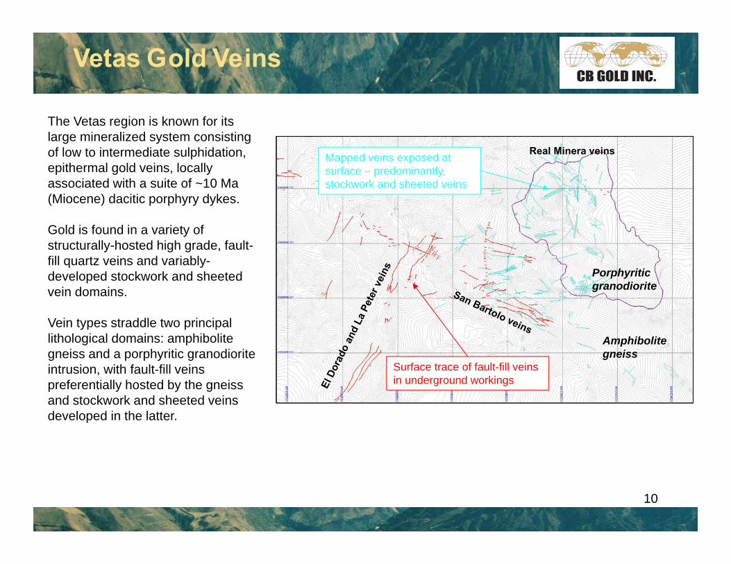
Vetas Gold Veins
The Vetas region is known for its large mineralized system consisting of low to intermediate sulphidation, epithermal gold veins, locally associated with a suite of ~10 Ma (Miocene) dacitic porphyry dykes.
Gold is found in a variety of structurally-hosted high grade, fault-fill quartz veins and variably-developed stockwork and sheeted vein domains.
Vein types straddle two principal lithological domains: amphibolite gneiss and a porphyritic granodioriteintrusion, with fault-fill veins preferentially hosted by the gneiss and stockwork and sheeted veins developed in the latter.
Amphibolitegneiss
Porphyritic granodiorite
Surface trace of fault-fill veins in underground workings
Mapped veins exposed at surface – predominantly, stockwork and sheeted veins
Real Minera veins

11
High Grade Fault-Fill Veins
The high grade fault-fill veins show multiple episodes of displacement and deposition, expressed as pulses of grey quartz and chalcedonic, crustiform silica, enclosed in clay alteration, bounded and transected by numerous slip surfaces.
Finely disseminated pyrite in quartz veins (“grey quartz”) is commonly associated with visible gold and silver. Veins strike primarily N60°W (e.g. El Dorado and La Peter), with a secondary set at N40°E (e.g. San Bartolo), and tend to cluster into two major corridors at these same orientations.
A major focus of the current drill program is to test the intersection between these two vein sets, in an area with extensive historical mining dubbed 'La Tesorito' (The Little Treasure).
Current mapping has also indicated a strong potential for kilometre-scale continuity of the structurally-hosted high grade vein corridors, and will be a primary focus of the step-out drilling program in the new year.

San BartoloEl Dorado
High Grade Fault-Fill Veins
The fault-fill veins are typical brittle shear veins and exhibit a variety of kinematic indicators, including: striations, slickensides, sigmoidal foliations, Riedel shears and asymetric jogs (see El Dorado and La Peter map insets). These features indicate predominantly stike-slip movement, with some oblique down-dip displacement.
High grade shoots are formed by the asymmetric jogs, which tend to form at dyke intersections, fault intersections and linkages between different fault segments. Plunge directions of the shoots are controlled by the local orientations of intersecting features.
5m
Dextral strike-slip displacement on NE trending faults such as at El Dorado and La Peter is compatible with the regional kinematics described in slide 7.
Careful mapping of satellite imagery has delineated sinistral offsets of El Dorado trending veins across San Bartolo trending structures. This kinematic configuration implies a conjugate relationship between the two fault-fill vein orientations formed in response to the same regional stresses described above. Although cross-cutting relationships observed to date indicate a younger age for San Bartolo veins, their textural and mineralogical simlarities suggest they are most likely to be broadly contemporaneous.
12

13
Stockwork and Sheeted Veins
The stockwork-sheeted vein zones exhibit varying degrees of intensity that coincide with grade, including broad zones of relatively continuous lower grade material (<1 g/t Au) and local concentrations of higher grade, tightly-spaced sheeted veins (>2 g/t Au). The latter zones may also contain abundant visible gold, as has been seen in the recent Real Minera drilling. Fault-fill veins may also penetrate the granodiorite and locally transect the stockwork-sheeted vein system; intersections that tend to coincide with multi-ounce intercepts at Real Minera.
High grade sheeted vein zones were exploited by historic mines of the conquistadors 13

14
Stockwork and Sheeted Veins
400.8 g/t Au from 147.0 - 147.70 metres
Stockwork and sheeted veins are superficially very similar in appearance: both are characterized by 1-2 cm wide veins of clear to milky quartz with finely disseminated pyrite. Sheeted veins have the distinction of a cm-wide phyllic alteration halo, which can give them a prominent weathering profile due to the associated silicification. Sheeted veins are also more consistently associated with higher grade gold mineralization, such as in drillhole RM-DDH11-056 (see inset below).

Stockwork veins exhibit a surprisingly regular, cylindrical distribution indicating they all share a common intersection plunging moderately to the northeast. Such a vein configuration suggests formation within a broadly isotropic, radial extension orthogonal to their line of intersection, which could be formed in response to regional uplift. A higher density of veins dipping northeast implies slightly greater extension in this direction, parallel to the regional extension direction.
Stockwork and Sheeted Veins
N = 140Stockwork veins
N = 58Sheeted veins
Line of intersection
Extension directions
In contrast, sheeted veins exhibit a very tight, singular orientation, which indicates a relatively punctuated sub-vertical extension. This extension direction is steeper, but close to the dominant extension direction indicated by the stockwork veins, suggesting a related, but more more constricted, stress field.
Cross-cutting relationships indicate a younger age for the sheeted vein population suggesting an evolution in the regional stress field to a more tightly-defined, steep NE-SW extension over time, which is also compatible with the WNW-ESE shortening and NNE extension indicated by the fault-fill veins.
Extension direction
15
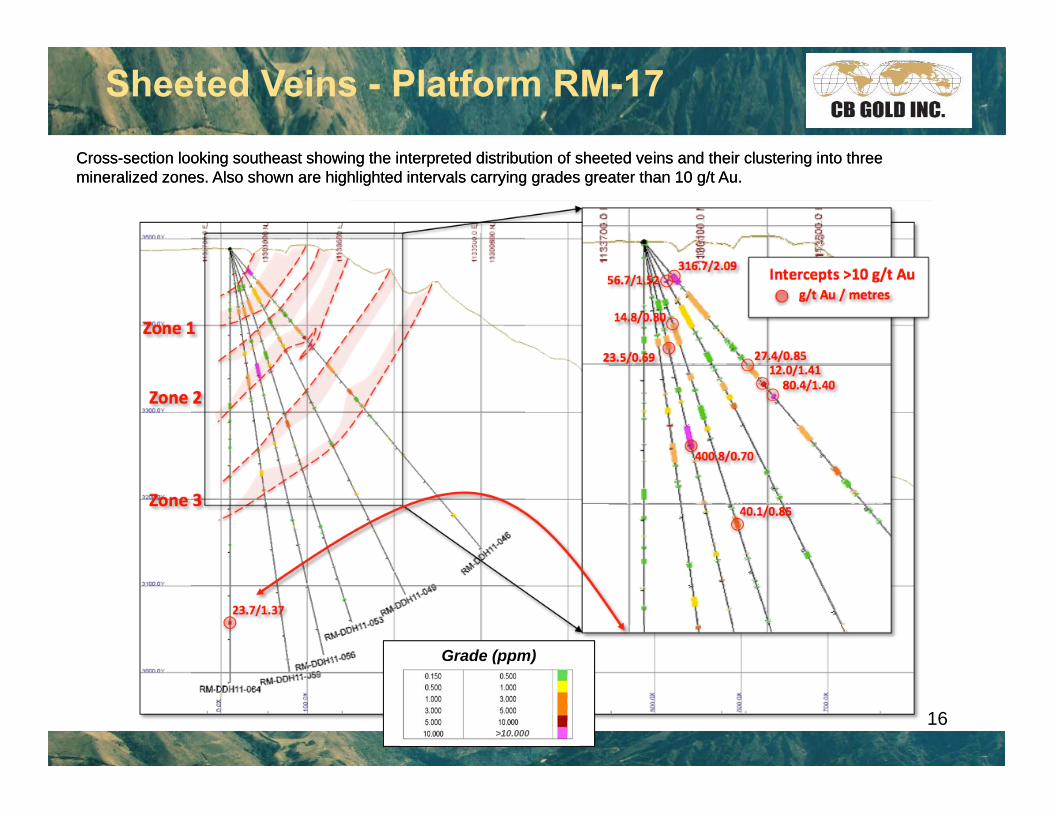
Sheeted Veins - Platform RM-17
Cross-section looking southeast showing the interpreted distribution of sheeted veins and their clustering into three mineralized zones. Also shown are highlighted intervals carrying grades greater than 10 g/t Au. Cross-section looking southeast showing the interpreted distribution of sheeted veins and their clustering into three mineralized zones. Also shown are highlighted intervals carrying grades greater than 10 g/t Au.
Grade (ppm)
>10.00016

Late Normal FaultingA system of north-south (~N020W trend) normal faults was identified in recent mapping by SRK. These faults are identified by north-south trending lineaments in the aerial photograph, field outcrops, and intersections in drill-core. These structures are the youngest structures observed on the property, and transect and offset all generations and styles of mineralized gold veins. Individual structures do not appear to have more that 1-2 m of displacement; however, these structures form part of a system of regularly spaced, parallel faults that are believed to have a significant amount of cumulative displacement and may be part of horst and graben system.
These north-south faults are also thought to be related to late slump-like features that dissect the topography at the higher elevations.
Town of Vetas
Real Minera
UP
DOWN
DOWN
Slickensides, fault gouge and breccias associated with late North-South fault zone
17
Structural Controls on Vetas Veins
The Vetas vein field was emplaced during the late-Miocene, in conjunction with the waning stages of tectonic activity in the Eastern Cordillera of the Colombian Andes. Gold-bearing fault-fill veins and extensional stockwork and sheeted veins formed in response to a regional stress field characterized by WNW-ESE compression and NNE-SSW extension. These forces operated on the NW-trending Bucaramanga Fault and its subsidiary secondary (e.g. Santander) and tertiary (e.g. Vetas and Cucutilla) faults, resulting in the uplift and exhumation of the Santander Massif. Local structures in the Vetas vein field mimicked these larger scale structures in terms of both their orientation and kinematics, with the addition of shallow dipping extensional sheeted veins reflecting the uplift component of the regional deformation. The radial extension exhibited by the stockwork veins is also compatible with regional uplift and exhumation.
The lithological preference of each different vein style is likely to be a reflection of the competence contrasts between the dominant lithological domains. For example, the more ductile gneisses are more prone to localizing strain into discrete fault zones, whereas the more competent and brittle granodiorite is prone to a broader strain distribution expressed by wide zones of fracturing and veining. As strain accumulates in the fault zones and in the granodiorite, the faults may eventually penetrate the brittle granodiorite and transect the stockwork and sheeted vein precursors. Where observed in core from Real Minera, this overprinting is associated with extreme high grades, exceeding 1 ounce per ton gold.
This new understanding of the Vetas vein system forms the backbone to the current 3D model and consequent targeting strategies. The predictability of vein orientations, strike extensions, structural intersections, dilational jogs and associated high grade shoots are all related to this kinematic framework. The added confidence in interpreted vein and structural continuity provides strong support to the geological model underpinning our resource estimation efforts.
The numerous property scale targets can be prioritized in terms of the constraints of the kinematic model.
18

SRK 3D Vein Model
Real Minera Sheeted Vein Zone
El Dorado Fault VeinSan Bartolo Vein System 100 m
La Peter Fault Fill Vein
Oblique view of 3D vein interpretation from SRK structural study. Colours distinguish between different vein families defined by style and preferred orientation.
Yellow and Blue: shear veins striking southwest (El Dorado & La Peter) and west-northwest (San Bartolo) respectively. Shear veins dip between 45-55 degrees to the north.
Red: stacked domains of east dipping porphyry-hosted sheeted veins (Real Minera).
The vein model solids span approximately 1.5km in a NE-SW direction. Drillholes typically range from 300m to 400m in length.
19

Vetas Mines
New model builds continuity between existing mines providing clear direction for delineation of Vetas resource and for exploration targets beyond known areas.
20

Vetas Mines
New model provides base model for 2012 resource delineation drilling at Real Minera
21

Vetas Mines
New model provides base model for 2012 resource delineation drilling at Real MineraGreen: 2011 drillingBlack: Proposed 2012 drilling
22

23
El Dorado drilling
Real Minera drilling
Down Dip + along Strike Targets
Down Dip + along Strike Targets
The conjugate set of fault-fill veins forms corridors of highgrade structures that transect the property
Intersections between the principal structures tend todevelop enhanced fracturing and permeability providingattractive exploration targets. Also, fault intersections withthe granodiorite pluton may also be expected to developzones of enhanced mineralization.
500m
Vetas: 2012 Drilling Targets
Faulted intersections with granodiorite pluton
References
Cediel, F., Shaw, R. P. and Caceres, C., 2003. Tectonic assembly of the Northern Andean Block, in C. Bartolini, R. T. Buffler, and J. Blickwede, eds., The Circum-Gulf of Mexico and the Caribbean: Hydrocarbon habitats, basin formation, and plate tectonics: AAPG Memoir 79, p. 815– 848.
Leal-Mejía, H., Melgarejo i Draper, J.C. and Shaw, R.P., 2011. Phanerozoic gold metallogeny in the Colombian Andes; SGA 2011 conference abstract, 3p.
Paris, G., Machette, M.N., Dart, R.L. and Haller, K.M., 2000. Map and Database of Quaternary Faults and Folds in Colombia and its Offshore Regions; International Lithosphere Program, U.S. Geological Survey Open File Report 00-0284, 61p.
Trippet, D., 2012. Structural study and modeling of the Vetas gold property, Colombia; CB Gold internal company report by SRK Consulting, 73p.
24

25
TSX-V: CBJ
Contact UsHead Office:
Suite 907, 1030 West Georgia St.Vancouver, BC, V6E 2Y3
T: (604) 630-5870 F: (604) 630-5871 Email: [email protected]