Embed Size (px)
Citation preview
Truro & Threemilestone Draft Final Report | November 2008
97
VI. HIGHERTOWN MASTERPLAN
This section considers the three major growth areas identified along the Highertown Ridge.
More detailed assessment of the area North of the A390 has allowed it to be considered in three distinct areas (Gloweth and Treliske, Golf Course and Willow Green), in addition to the two distinc areas south of the A390. The following areas are therefore considered:
• Gloweth & Treliske,
• Golf Course,
• Willow Green,
• Highertown, and
• Besore.
A broad Vision is outlined for each area. Its performance is then apprised against the masterplanning criteria outlined in Section II, namely
• Reinforcing the city centre;
• Protecting the long term landscape setting;
• Providing high quality jobs; and
• Promoting sustainable communities.
A summary of the development areas delivered, residential capacity achieved and the key delivery issues for each area is then provided..
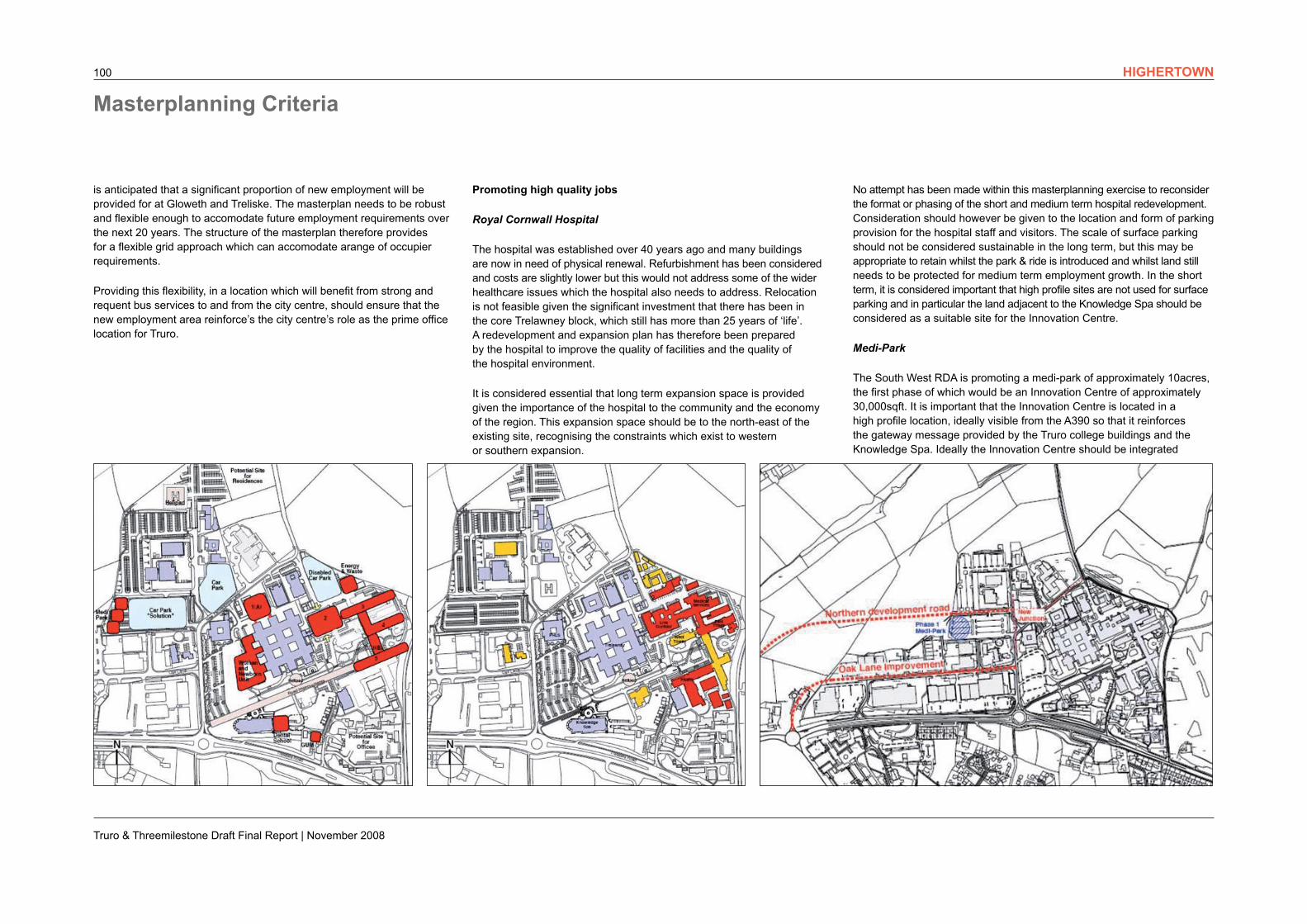
District centre is a focus for retail, leisure and stuident key worker accommodation.
Grid structure allows flexibility for phasing of new employment.
Expansion of hospital.
New commercial buildings to front the A390.
A390 improved for bus priority and pedestrian crossings.
Variety of access points to spread traffic.
Truro College buildings announce arrival in the ‘modern city’.
Green corridor protected.
Residential focus on rural fringe.
Opportunity for combined heat and power plan (CHP).
Truro & Threemilestone Draft Final Report | November 2008
99
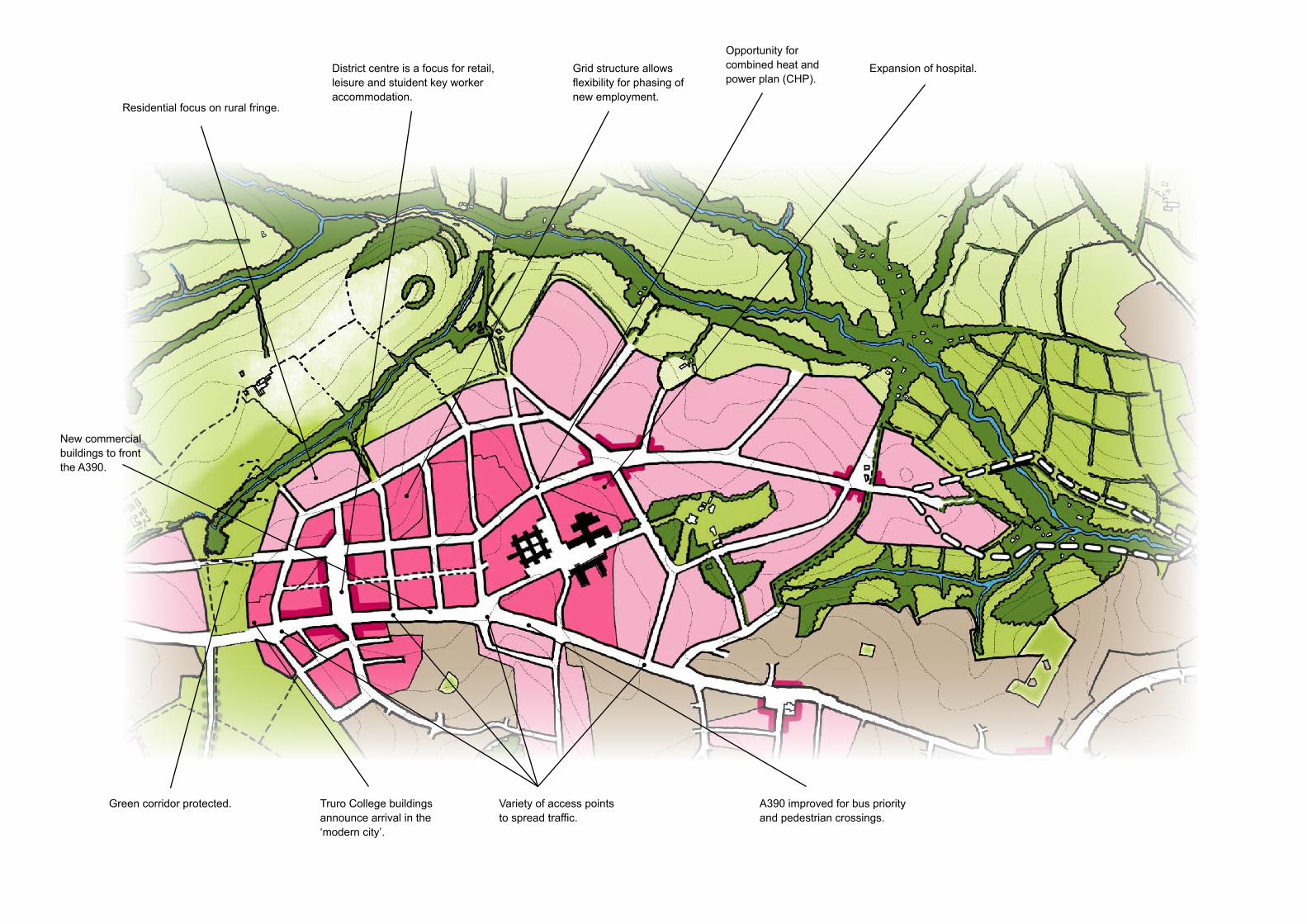
Gloweth & Treliske – The Modern City
Vision for the Area
Gloweth & Treliske will be the ‘Modern City’ on the Highertown Ridge, complementing the historic city in the bowl, with a mix of uses creating a genuinely sustainable community and a focus for sustainable energy.
Truro College will continue to expand and be a focus for higher and further education in Truro. High quality buildings north and south of the A390 will front the street as a gateway to Truro’s modern city. Improved leisure facilities and increased student accommodation will provide an integrated, mixed-use environment and a vibrant campus feel.
Royal Cornwall Hospital will expand and provide a higher quality service and environment for patients. It will be a focus for new jobs in the health sector, and links to the medi-park will stimulate growth in research and the ‘knowledge economy’. It will be a location for key worker housing which support the economy and brings life and activity in the evening.
The new district centre will be at the heart of the new development, serving the business, resident and student community. A ‘High Street’ feel will connect Truro College to Royal Cornwall Hospital, and serve the surrounding residential communities.
The park & ride will provide fast and frequent services from the east and west, direct to the college, district centre, hospital and other employment. High quality links to the city centre and the rail station will create a connected and sustainable mixed-use business environment.
HIGHERTOWN
Truro & Threemilestone Draft Final Report | November 2008
100
Promoting high quality jobs
Royal Cornwall Hospital
The hospital was established over 40 years ago and many buildings are now in need of physical renewal. Refurbishment has been considered and costs are slightly lower but this would not address some of the wider healthcare issues which the hospital also needs to address. Relocation is not feasible given the significant investment that there has been in the core Trelawney block, which still has more than 25 years of ‘life’. A redevelopment and expansion plan has therefore been prepared by the hospital to improve the quality of facilities and the quality of the hospital environment.
It is considered essential that long term expansion space is provided given the importance of the hospital to the community and the economy of the region. This expansion space should be to the north-east of the existing site, recognising the constraints which exist to western or southern expansion.
is anticipated that a significant proportion of new employment will be provided for at Gloweth and Treliske. The masterplan needs to be robust and flexible enough to accomodate future employment requirements over the next 20 years. The structure of the masterplan therefore provides for a flexible grid approach which can accomodate arange of occupier requirements.
Providing this flexibility, in a location which will benefit from strong and requent bus services to and from the city centre, should ensure that the new employment area reinforce’s the city centre’s role as the prime office location for Truro.
Masterplanning Criteria
No attempt has been made within this masterplanning exercise to reconsider the format or phasing of the short and medium term hospital redevelopment. Consideration should however be given to the location and form of parking provision for the hospital staff and visitors. The scale of surface parking should not be considered sustainable in the long term, but this may be appropriate to retain whilst the park & ride is introduced and whilst land still needs to be protected for medium term employment growth. In the short term, it is considered important that high profile sites are not used for surface parking and in particular the land adjacent to the Knowledge Spa should be considered as a suitable site for the Innovation Centre.
Medi-Park
The South West RDA is promoting a medi-park of approximately 10acres, the first phase of which would be an Innovation Centre of approximately 30,000sqft. It is important that the Innovation Centre is located in a high profile location, ideally visible from the A390 so that it reinforces the gateway message provided by the Truro college buildings and the Knowledge Spa. Ideally the Innovation Centre should be integrated
HIGHERTOWN
Truro & Threemilestone Draft Final Report | November 2008
101
physically with the hospital redevelopment and expansion, but if this is not possible consideration should be given to integrating the Innovation Centre with the new Truro College building north of the A390.
Truro College
Truro College now has around 1,000 Higher Education students, and the recent Fal building, which opened in 2006, is the focus for Higher Education activity. The success of the college means there is pressing demand for both academic space and for student accommodation.
Although the recent scale of growth is considered unlikely to continue, there is an immediate (within the next three years) requirement for a further 6,000sqm (equivalent to the Fal Building) of teaching space and up to 400 student bedrooms. In the longer term flexibility is required to allow for a possible further 6,000sqm of teaching space.
As the College has exhausted its land holdings, it is considering growth north of the A390 for both the teaching and residential accommodation. Whilst there are benefits in maintaining a degree of physical separation between teaching and residential space, there is a need for close integration of the new academic building with the existing campus.
Business and Education Links
The design of the existing campus, the topography and road layout has made integration of facilities more difficult. In addition the barrier currently created by the A390 needs to be addressed in any future development. The objective should be to create a more integrated campus, north and south of the A390.
The opportunity can also be taken to integrate some of the business-oriented facilities within the College with the wider employment growth anticipated in the Gloweth/Treliske area. For example, the Skills Centre could be incorporated as part of the Medi-Park expansion, and the Business Centre, currently housed in Palace Buildings, would benefit from more effective connections with the main college buildings.
Protecting the Landscape Setting
Much of the area identified for long term employment growth comprises redevelopment and intensification of existing brownfield areas. The Landscape Framework identifies the immediately surrounding area as being suitable for development.
The steepness of the valley slopes between Willow Green and Gloweth/Treliske area prevent development in this area. The Landscape Framework and Green Infrastructure Strategy identifies this area ‘Highertown Pass’ as an important green connection between the Kenwyn Valley and the Tinney and Calennick Valley.
An oil pipeline also runs through this area and needs to be avoided. This reinforces the linked but separate identity of the village of Threemilestone. Willow Green would therefore be developed as a separate residential community, but with good walking and cycling connections to the Gloweth/Treliske area. The new Truro College buildings, and the district centre, would mark the arrival into the new employment area after visitors have travelled through the ‘Highertown Pass’ green link.
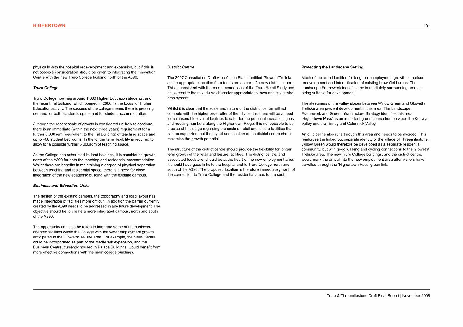
District Centre
The 2007 Consultation Draft Area Action Plan identified Gloweth/Treliske as the appropriate location for a foodstore as part of a new district centre. This is consistent with the recommendations of the Truro Retail Study and helps creatre the mixed-use character appropriate to town and city centre employment.
Whilst it is clear that the scale and nature of the district centre will not compete with the higher order offer of the city centre, there will be a need for a reasonable level of facilities to cater for the potential increase in jobs and housing numbers along the Highertown Ridge. It is not possible to be precise at this stage regarding the scale of retail and leisure facilities that can be supported, but the layout and location of the district centre should maximise the growth potential.
The structure of the district centre should provide the flexibility for longer term growth of the retail and leisure facilities. The district centre, and associated foodstore, should be at the heart of the new employment area. It should have good links to the hospital and to Truro College north and south of the A390. The proposed location is therefore immediately north of the connection to Truro College and the residential areas to the south.
HIGHERTOWN
Truro & Threemilestone Draft Final Report | November 2008
102
In accordance with the Retail, Offices and Leisure study conclusions, priority has been given to delivering these uses on sites within, or adjacent to, the city centre. There is however a requirement to make provision for additional employment growth and in particular for growth in the knowledge economy. Treliske is a natural focus for such growth as it is already subject of the following proposals:
• Expansion and redevelopment of Royal Cornwall Hospital,
• Growth of Truro College,
• Development of a medi-park.
These factors, combined with the accessibility of the area from the park & ride service, the relatively flat topography and the identification of the area as suitable for development within the Landscape Framework make it a natural focus for employment growth. The masterplanning exercise incorporates all these elements of employment growth, which have been the subject of consultation with Royal Cornwall Hospital, Truro College and the South West RDA (as promoters of the medi-park).
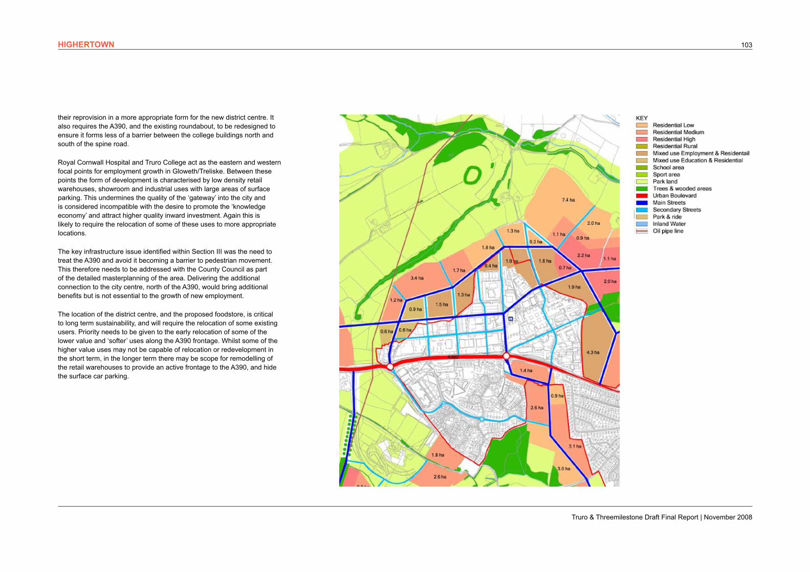
Around 16ha is identified for growth of the employment area at Gloweth & Treliske, in addition to the intensification and redevelopment of the existing area. In addition to the key worker housing and student accommodation which would be provided within this primarily employment area, a further 10ha of land has been identified immediately to the north and west which would have the capacity for at least a further 300 dwellings.
The priority is to ensure the growth of Truro College and Royal Cornwall Hospital and the development of the medi-park is supported within the context of a co-ordinated masterplan. The grid structure of the masterplan allows for flexibility in locations and phasing to enable this to happen and discussions with the key parties are on-going. Further detailed consultation will however be needed with all the major landowners in order to coordinate the development proposals.
The park & ride is the first indication to visitors arriving from the west that they are approaching Truro. It should not however signal arrival in the city, or arrival in Gloweth/Treliske as this could undermine patronage. Truro College, and the district centre, should therefore be the ‘gateway’ to Truro and will indicate the focus on the ‘knowledge economy’ in Gloweth/Treliske. In the short and medium term this will require relocation of the poor quality retail units (Pizza Hut and McDonalds) in this area, and
Creating sustainable communities
A mixed-use approach is essential to create the ‘town centre character’ that will attract high quality employment and create a sustainable environment.
Student accommodation and key worker housing can be developed in close proximity to the growth of Truro College and Royal Cornwall Hospital. The opportunity must be taken to integrate such development within the district centre, for example above the proposed foostore. This will help support the employment growth and generate the demand for additional facilities during the day and the evening.
The rural fringe to the north of the core employment area has the capacity to accommodate sensitively designed housing in locations consistent with the Landscape Framework. Providing a range of housing and student accommodation close to the employment and shopping facilities will create a more balanced approach to development north and south of the A390 and will also serve to:
• improve the quality of employment development;
• enhance the viability of the district centre;
• make more effective use of available parking; and
• improve sustainability by maximising walking, cycling and use of public transport;
Sustainable energy
Although the slopes are generally north facing, the opportunity will be taken to inverse densities which, together with the mix of uses, maximises the potential for renewable energy to be delivered on-site through a combined heat and power plant (District CHP).
Delivery
Sense of place
A high quality sense of place can be created on the fringe of the employment area, with views to the surrounding countryside and access to a range of facilities. Residents will benefit from:
• a high quality residential environment;
• easy access on foot or cycle to surrounding countryside;
• easy access to employment, health, education, leisure and retail facilities; and
• a direct and regular bus service to the city centre and County Hall as major employment centres.
Summary
It is considered that the Gloweth and Treliske area meets the following key sustainability criteria:
• It delivers high value jobs in the knowledge economy
• It delivers key worker and student accommodation
• It delivers a critical mass of employment and resident population to support the district centre
• It is highly accessible by public transport
• It minimises overall landscape and ecological impact and has the potential to enhance the natural environment,
• It has the potential to integrate with adjacent houisng areas to create a high quality ‘sense of place’.
HIGHERTOWN
Truro & Threemilestone Draft Final Report | November 2008
103
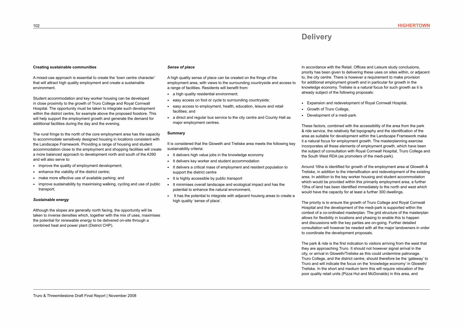
their reprovision in a more appropriate form for the new district centre. It also requires the A390, and the existing roundabout, to be redesigned to ensure it forms less of a barrier between the college buildings north and south of the spine road.
Royal Cornwall Hospital and Truro College act as the eastern and western focal points for employment growth in Gloweth/Treliske. Between these points the form of development is characterised by low density retail warehouses, showroom and industrial uses with large areas of surface parking. This undermines the quality of the ‘gateway’ into the city and is considered incompatible with the desire to promote the ‘knowledge economy’ and attract higher quality inward investment. Again this is likely to require the relocation of some of these uses to more appropriate locations.
The key infrastructure issue identified within Section III was the need to treat the A390 and avoid it becoming a barrier to pedestrian movement. This therefore needs to be addressed with the County Council as part of the detailed masterplanning of the area. Delivering the additional connection to the city centre, north of the A390, would bring additional benefits but is not essential to the growth of new employment.
The location of the district centre, and the proposed foodstore, is critical to long term sustainability, and will require the relocation of some existing users. Priority needs to be given to the early relocation of some of the lower value and ‘softer’ uses along the A390 frontage. Whilst some of the higher value uses may not be capable of relocation or redevelopment in the short term, in the longer term there may be scope for remodelling of the retail warehouses to provide an active frontage to the A390, and hide the surface car parking.
HIGHERTOWN

Local centre showing residential and employment areas.
Lower density housing on rural fringe.
Strategic sustainable urban drainage systems.
‘Village’ centre.
Kenwyn Valley protected as green route to city centre.
Public transport route to city centre.
Important biodiversity site protected.
School grounds protected.Housing within 200m of public transport routes.
Higher density housing close to local centre.
Setting of scheduled ancient monument protected.
Truro & Threemilestone Draft Final Report | November 2008
105
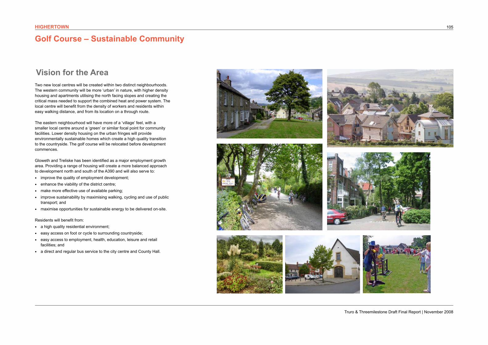
Golf Course – Sustainable Community
Vision for the AreaTwo new local centres will be created within two distinct neighbourhoods. The western community will be more ‘urban’ in nature, with higher density housing and apartments utilising the north facing slopes and creating the critical mass needed to support the combined heat and power system. The local centre will benefit from the density of workers and residents within easy walking distance, and from its location on a through route.
The eastern neighbourhood will have more of a ‘village’ feel, with a smaller local centre around a ‘green’ or similar focal point for community facilities. Lower density housing on the urban fringes will provide environmentally sustainable homes which create a high quality transition to the countryside. The golf course will be relocated before development commences.
Gloweth and Treliske has been identified as a major employment growth area. Providing a range of housing will create a more balanced approach to development north and south of the A390 and will also serve to:
• improve the quality of employment development;
• enhance the viability of the district centre;
• make more effective use of available parking;
• improve sustainability by maximising walking, cycling and use of public transport; and
• maximise opportunities for sustainable energy to be delivered on-site.
Residents will benefit from:
• a high quality residential environment;
• easy access on foot or cycle to surrounding countryside;
• easy access to employment, health, education, leisure and retail facilities; and
• a direct and regular bus service to the city centre and County Hall.
HIGHERTOWN
Truro & Threemilestone Draft Final Report | November 2008
106
Sustainable energy
Although the slopes are generally north facing, which reduces the potential for solar gain,opportunities for CHP are maximised by the increased densities and mixing employment and housing in the wider area.
Sense of Place
A high quality sense of place can be created in this area, creating distinctive communities with their own identity and with access a wider range of facilities and job opportunities in the city centre and new employment areas. The rural fringe will provide easy access to the countryside for recreation and education. A new bus, cycle and pedestrian route will provide direct access to the city centre, avoiding the A390. The green links will provide safe and immediate access to the countryside and connect the north of the city to the city centre and onto its waterfront.
Summary
It is considered that the Golf Course area meets the following key sustainability criteria:
• It creates a critical mass of population which can support local services, ie a sustainable local community
• It is accessible by walking, cycling or public transport to the city centre and Treliske in particular and also to County Hall
• It can deliver essential infrastructure, and in particular sustainable urban drainage systems and green infrastructure, to minimise flooding impact
• It minimises overall landscape and ecological impact and has the potential to enhance the natural environment,
• It has the potential to integrate with adjacent houisng areas to create a high quality ‘sense of place’.
Protecting the long term landscape setting
The Landscape Strategy for Truro (2000) considered this area to have a ‘moderately sensitive landscape’ and was concerned at the potential impact of development on the ‘intrinsic quality of the valleyside and on the setting of the ridge-top settlements’.
The Landscape Framework identifies the majority of this area as suitable for development. The masterplan proposals respect the most sensitive area of the Kenwyn Valley to the north which is an important ecological asset and which the landscape strategy states ‘would define the natural edge of new development to the north of the Highertown to Threemilestone ridge’. It also protects the green corridor of the Kenwyn Valley running into the city and the important biodiversity site to the east.
Reinforcing the City Centre
The Golf Course area will link primarily to the new employment at Gloweth and Treliske. It does however have good walking links to the city centre and the potential for a direct bus service to be provided. The masterplan therefore provides for this new connection, which will give residents access to the jobs and facilities in the city centre without increasing the parking and traffic problems.
Providing high value jobs
The golf course area will not support high value jobs directly. It will however have excellent access to both the Gloweth/Treloske area, and to the city centre via the proposed public transport connection. Increasing the resident labour market in such a strategic location should make the city centre and the employment growth areas more attractive to businesses and thus promote high value jobs.
Creating sustainable communities
The Housing Sustainability Index report prepared by Roger Tym & Partners for the County and District Council in 2002 used a ‘sustainability assessment matrix’ to rank alternative housing sites.
The Gloweth area scored highly in relation to transport, proximity to jobs and services and deliverability. The development of the hospital, Truro College, medipark, district centre and park & ride will all improve the sustainability of the Gloweth/Treliske area.
The importance of this area for employment growth has been recognised earlier in this report. Royal Cornwall Hospital, Truro College and other businesses in this area account for around 40% of the employment in Truro. Minimising the need to travel, and maximising accessibility by walking, cycling and public transport to key ‘travel generators’ is a core sustainability principle at the heart of the Area Action Plan and of this masterplan.
Land to the north and east of the employment area is relatively flat. It can support the critical mass of housing which can create a sustainable community with its own facilities and local centre, as well as having access to the district centre and job opportunities. The local centres can be located on through routes to increase their viability. These through routes can support new bus services which will pass within 200m of all new homes.
It is close to the Richard Lander secondary school and to the proposed district centre and associated services. The area is also within easy walking distance of the main bus routes and park & ride service into the centre of Truro and County Hall. A new bus route, with enhanced cycle and walking connections, will link directly to the city centre. The area therefore has good access to jobs and facilities.
SuDS
There is potential for strategic SuDS to be integrated into the development with opportunities for linear ponds to the south east and dry basins to the north of the proposed development areas. The main constraint with on-site SuDS is the elongated shape of the site.
Masterplanning CriteriaHIGHERTOWN
Truro & Threemilestone Draft Final Report | November 2008
107
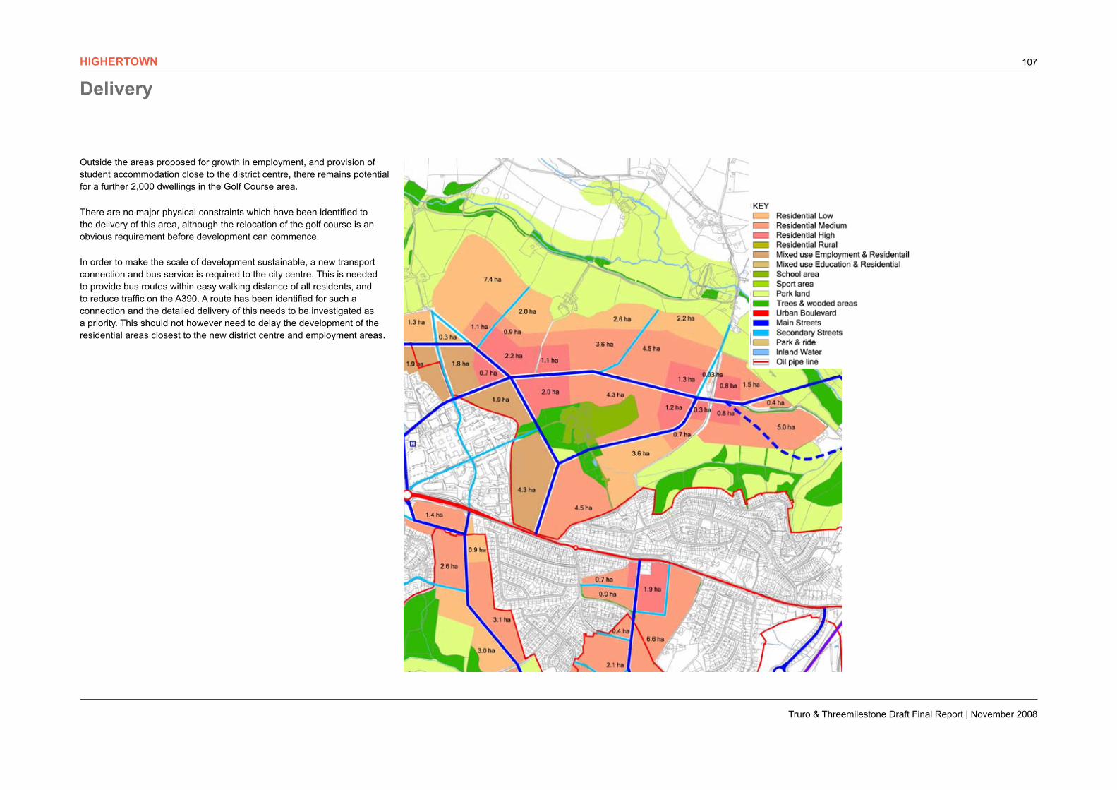
Outside the areas proposed for growth in employment, and provision of student accommodation close to the district centre, there remains potential for a further 2,000 dwellings in the Golf Course area.
There are no major physical constraints which have been identified to the delivery of this area, although the relocation of the golf course is an obvious requirement before development can commence.
In order to make the scale of development sustainable, a new transport connection and bus service is required to the city centre. This is needed to provide bus routes within easy walking distance of all residents, and to reduce traffic on the A390. A route has been identified for such a connection and the detailed delivery of this needs to be investigated as a priority. This should not however need to delay the development of the residential areas closest to the new district centre and employment areas.
DeliveryHIGHERTOWN

Very low density housing on rural fringe.
Possible location for community farm.
Connection to district centre and employment area.
Green corridor overlooked by housing and education buildings.
Higher density housing close to local centre and park and ride.
Treated A390 to improve bus priority and pedestrian crossings.
Local centre benefits from passing trade
Truro & Threemilestone Draft Final Report | November 2008
109
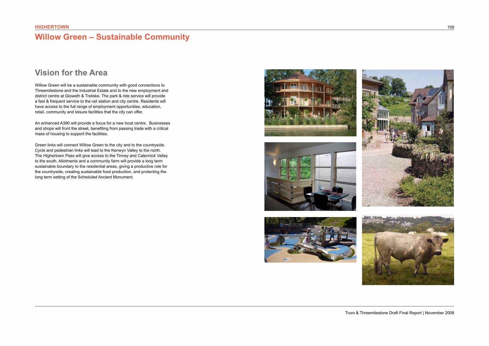
Willow Green – Sustainable Community
Vision for the AreaWillow Green will be a sustainable community with good connections to Threemilestone and the Industrial Estate and to the new employment and district centre at Gloweth & Treliske. The park & ride service will provide a fast & frequent service to the rail station and city centre. Residents will have access to the full range of employment opportunities, education, retail, community and leisure facilities that the city can offer.
An enhanced A390 will provide a focus for a new local centre. Businesses and shops will front the street, benefiting from passing trade with a critical mass of housing to support the facilities.
Green links will connect Willow Green to the city and to the countryside. Cycle and pedestrian links will lead to the Kenwyn Valley to the north. The HIghertown Pass will give access to the Tinney and Calennick Valley to the south. Allotments and a community farm will provide a long term sustainable boundary to the residential areas, giving a productive role for the countryside, creating sustainable food production, and protecting the long term setting of the Scheduled Ancient Monument.
HIGHERTOWN
Truro & Threemilestone Draft Final Report | November 2008
110
access to the countryside and connect to the city centre and onto its waterfront. The key issue to be addressed is the frontage to the A390 and the relationship with the existing community, and local centre, at Threemilestone.
Summary
It is considered that the Willow Green area meets the following key sustainability criteria:
• It creates a critical mass of population which can support local services, ie a sustainable local community
• It is accessible by walking, cycling or public transport to the city centre, Treliske, Threemilestone Industrial Estate and County Hall
• It can deliver essential infrastructure, and in particular sustainable urban drainage systems and green infrastructure, to minimise flooding impact
• It minimises overall landscape and ecological impact and has the potential to enhance the natural environment,
• It has the potential to integrate with adjacent houisng areas to create a high quality ‘sense of place’..
Creating sustainable communities
The Willow Green area lies between the park & ride and the Gloweth/Treliske growth area. It has the capacity to deliver at least 1,000 dwellings and has the potential to relate to both the Threemilestone local centre and to the proposed district centre. It would be within easy walking distance of the Richard Lander school, Truro college, Royal Cornwall Hospital and associated employment and be close to the main bus route to County Hall and the city centre.
There is potential for allotments and a Community Farm immediately to the north which would give residents easy access to sustainable food production.
SuDS
There do not appear to be any particular constraints to the use of SuDS on this site. The site is likely to be separated into two for drainage purposes, each section centred on each of the two streams.
Sustainable energy
Opportunities for CHP are maximised by proximity to major employment and housing in the area.
Sense of Place
A high quality ‘sense of place’ can be created in this area, creating a distinctive community with its own identity and with access to a wider range of facilities and job opportunities in the new and existing employment areas. The rural fringe will provide easy access to the countryside for recreation and education. The park & ride service and new green links will provide direct access to the city centre, avoiding congestion on the A390. The green links will provide safe and immediate
Protecting the landscape setting
The Truro Landscape Strategy considered the WIllow Green area as part of TL14 Upper Kenwyn valleyside (south). The Landscape Strategy considered this area to have a ‘moderately sensitive landscape’ and was concerned at the potential impact of development on the ‘intrinsic quality of the valleyside and on the setting of the ridge-top settlements’. The sustainability assessment in 2006 noted that the proposed growth in employment in Gloweth/Treliske changes the nature of the landscape and that as a result, additional development in the Willow Green area was considered acceptable.
The Landscape Framework identiies the area as suitable for development. The masterplan protects the sensitive ‘Highertown Pass’ and creates a green corridor between Willow Green and the Gloweth/Treliske area. Development is kept away from the Scheduled Ancient Monuments to the north and the World Heritage Site to the west.
Reinforcing the City Centre
The Willow Green area will link primarily to the new employment at Gloweth and Treliske and to the Threemilestone Industrial Estate. It does however have good public transport links to the city centre via the park & ride service. Residents will therefore have access to the jobs and facilities in the city centre, and along the A390 corridor, without increasing the parking and traffic problems.
Providing high value jobs
The Willow Green area will not support high value jobs directly. It will however have excellent access to both the Gloweth/Treliske area, and to the city centre via the proposed public transport connection. Increasing the resident labour market in such a strategic location should make the city centre and the employment growth areas more attractive to businesses and thus promote high value jobs.
Masterplanning CriteriaHIGHERTOWN
Truro & Threemilestone Draft Final Report | November 2008
111
Delivery
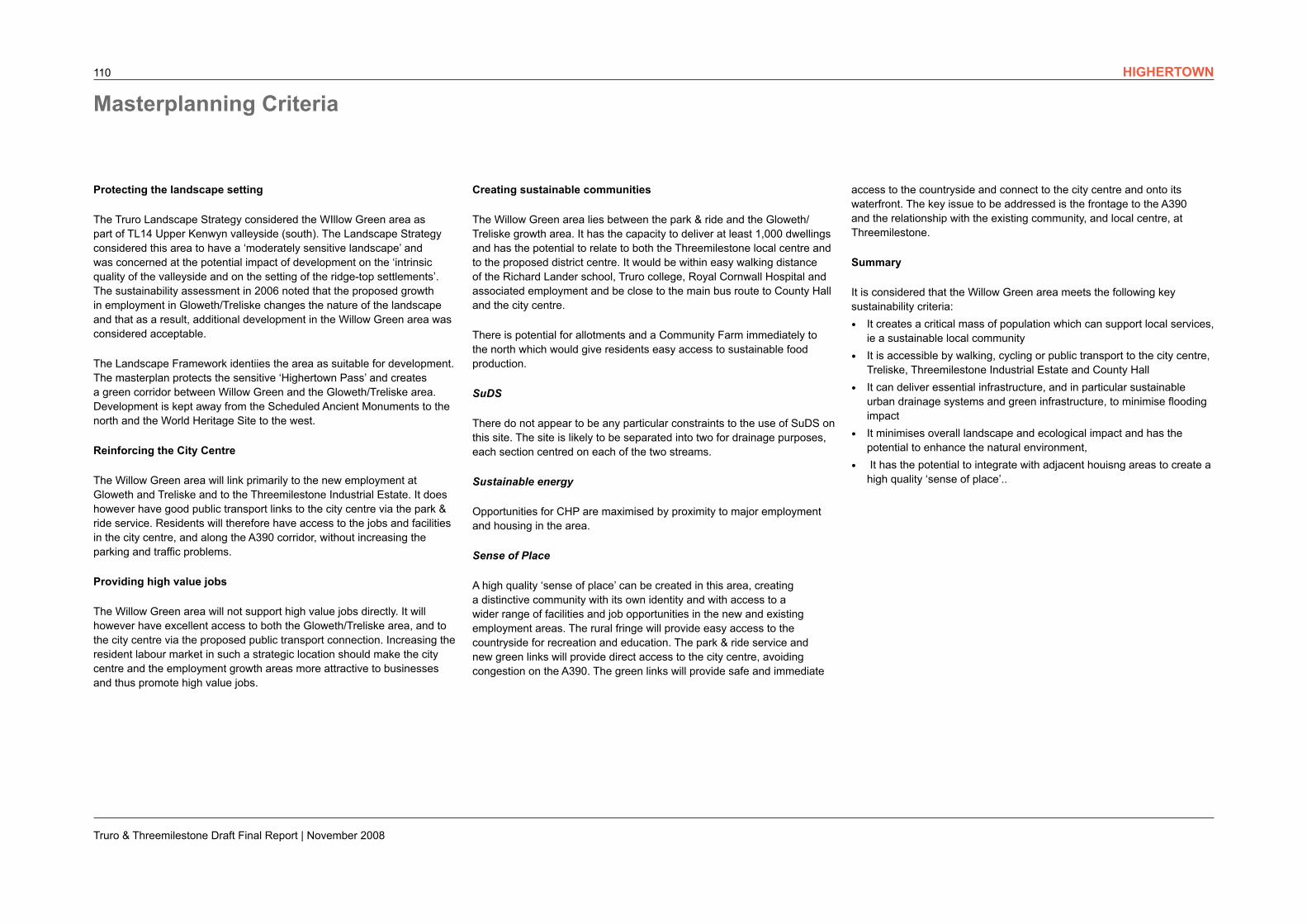
There is potential for approximately 900 dwellings in the Willow Green area. There are no major physical constraints which have been identified to the delivery of this area.
The key physical issues to be addressed are the treatment of the A390, to create an attrative development frontage and to create connections with Threemilestone, and the creation of appropriate connections to the new employment and district centre within Gloweth and Treliske. The detailed treatment of the Highertown Pass therefore needs to consider the form and location of new development on both sides of the green corridor.
HIGHERTOWN
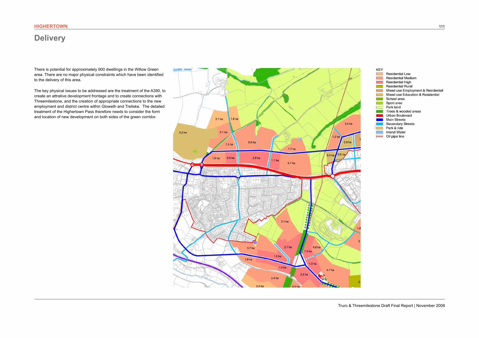
Connections with existing residential areas.
A390 treated to improve bus priority and pedestrian crossings.
Existing permission from Persimmon site.
Higher density housing close to local centres and strategic bus routes.
Redevelopment of former Richard Lander School provides opportunity for new local centre.
Protected nature conservation area.
Lower density housing on rural fringe.
Access points for enhanced bus service from local distributor road.
Tinney Valley protected as green link.
Truro & Threemilestone Draft Final Report | November 2008
113
Highertown – Sustainable Community
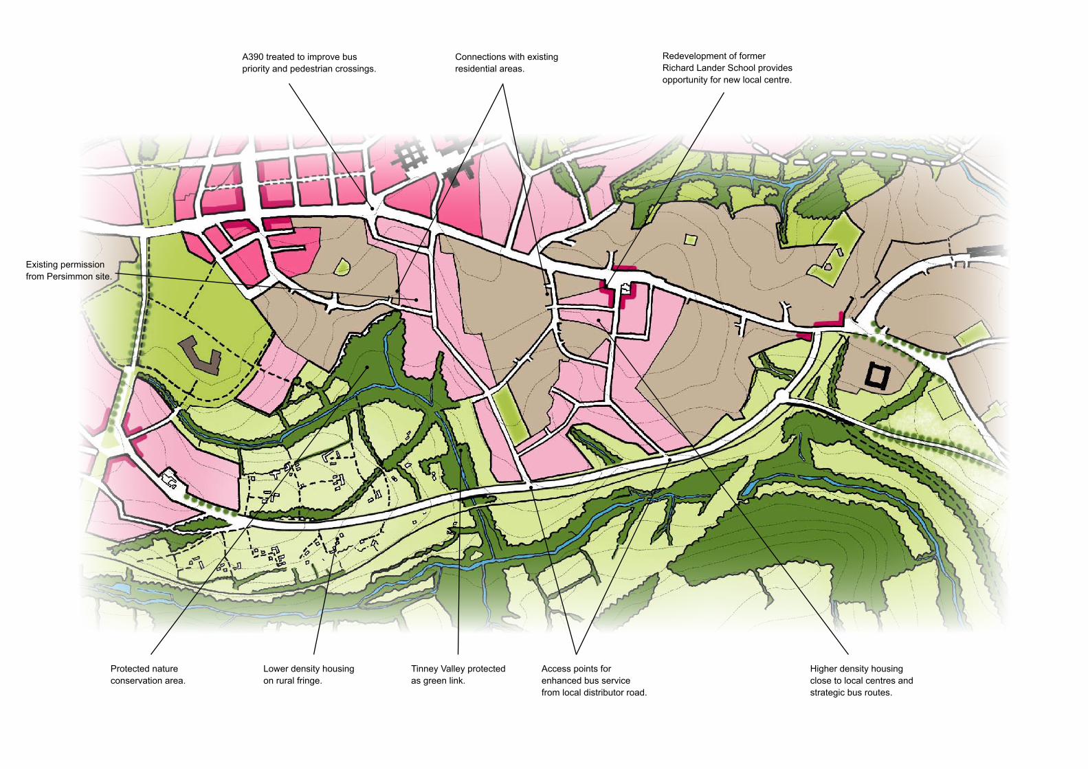
Vision for the AreaHighertown development will create a more integrated and sustainable community, connecting existing residential areas, public transport routes and new facilities. New and existing residents will support expanded local facilities and have improved access to employment, retail and leisure services. The former Richard Lander school will support an enhanced local centre serving new and existing residents.
Residents will also benefit from proximity to Treliske, the district centre and Truro College. The strategic accessibility that will come from the proposed Local Distributor Road will also facilitate improved bus services to Truro City Centre and County Hall.
Providing a critical mass of housing in this area will:
• improve sustainability by maximising walking and cycling to local facilities;
• support a new local centre with opportunities for small scale retail and local employment; and
• improve the viability of bus services along the proposed LDR.
Residents will benefit from:
• a high quality residential environment and new local centre;
• easy access to employment, health, education, recreation, leisure and retail facilities;
• easy access on foot or cycle to local nature conservation areas and to the surrounding countryside; and
• a direct and regular bus service to the city centre, Treliske and County Hall.
HIGHERTOWN
Truro & Threemilestone Draft Final Report | November 2008
114
Sense of place
The Highertown area is close to existing facilities and residential areas. Whilst it does not have the potential of other areas to create a separate and distinctive identity, it does have the potential to improve the physical environment, and the sustainability, of existing residential areas as well as providing a hogh quality environment for new residents. Residents will have easy access to range of facilities and to the countryside to the south of the city.
Summary
It is considered that the Highertown area meets the following key sustainability criteria:
• It creates a critical mass of population which can support local services, ie a sustainable local community
• It is accessible by walking, cycling or public transport to Treliske and County Hall and the LDR has the potential to provide sustainable access to the city centre and Threemilestone Industrial Estate
• It can deliver essential infrastructure, and in particular sustainable urban drainage systems and green infrastructure, to minimise flooding impact
• It minimises overall landscape and ecological impact and has the potential to enhance the natural environment,
• It has the potential to integrate with adjacent houisng areas to create a high quality ‘sense of place’.
Creating a sustainable community
The Highertown area has the potential to deliver up to 1500 dwellings. The ‘Persimmon site’ has an existing planning permission and the former Richard Lander school has been identified in previous reports as suitable for residential development. Additional development close to these sites can help support additional facilities. Passing trade on the A390 makes this a suitable location for local centres.
Both sites are close to the A390 spine road and are potentially accessible to major bus routes but the form of development is critical in ensuring connections are made to adjacent residential areas and other facilities. The Local Distributor Road connections to the south are essential to improve accessibility by bus. Connections also need to be made between new development and existing residential areas to help improve permeability for cyclists, pedestrians and buses.
SuDS
SuDS are likely to be located adjacent to the two valleys. The railway line may form a constraint on the route of water to the River Tinney. Both streams crossing the site also cross the railway line before their confluences with the river. SuDS schemes on this site need to take account of the drainage system for the LDR and may need to work in conjunction with it.
Sustainable energy
The land is relatively flat which gives the opportunity to maximise densities and create the catchment needed to support local facilities. The slopes which do exist within the site are all south facing, which maximises the opportunities for passive solar gain.
Protecting the landscape setting
The Landscape Strategy for Truro (2000) includes the Highertown area within the broader area defined as TL13 (Besore valleyside farmland) and summarised as ‘Parts of area with development potential’. The ‘Persimmon site’ and land south of the former Richard Lander school were specifically identified as having development potential.
The Landscape Strategy identifies the area as having development potential. The masterplan avoids the sensitive areas of the Calennick Valley and the HIghertown Pass (Kenwyn/Tinney link). It also avoids the sensitive biodiversity sitres at Halbullock Moor, Gloweth Strean and West of Penwithers Junction identiied in the Landscape Framework.
Reinforcing the City Centre
The HIghertown area will link primarily to the new employment at Gloweth and Treliske and to County Hall. Reinforcing the city centre is dependent on a new connection, and public transport route, to the south of the A390. Delivery of the Local Distributor Road, and a route serving residents of Besore, is therefore critical to achieving this.
Providing high value jobs
The Highertown area will not support significant numbers of high value jobs directly. It will however have good access to both the Gloweth/Treliske area and to County Hall. and potentially to the city centre via the Local Distributor Road. The new connection provided by the LDR should ensure good access to the city centre could also be extended to provide a southern access into the Industrial Estate. Increasing the resident labour market in such a strategic location should make the city centre and the employment growth areas more attractive to businesses and thus promote high value jobs.
Masterplanning CriteriaHIGHERTOWN
Truro & Threemilestone Draft Final Report | November 2008
115
Delivery
There is potential for approximately 1,000 dwellings in the Highertown area. There are no major physical constraints which have been identified to the delivery of new housing in the northern part of this area.
The key physical issue to be addressed is the delivery of the Local Distributor Road. This is essential to provide bus services to the city centre and the new employment destinations at Gloweth & Treliske, and avoid the creation of a cul-de-sac accessed only from the A390.
Detailed traffic modelling would be needed to assess the scale of development which can proceed in advance of the LDR being completed.
HIGHERTOWN
Improvement to Threemilestone local centre.
River valley protected as green link.
Local distributor road provides passing trade for local centre.
Public transport route to city centre.
New viaduct for LDR to protect the valley bottom.
New local centre for Besore.
LDR provides strategic bus route to city centre.
Very low density housing on rural fringe.
Pipeline corridor protected.
New southern access to reduce ‘rat-running’ through Threemilestone.
Lower density housing around fringe.
Higher density housing around local centre and bus routes.
Potential new access to industrial estate.
Shared community and leisure facilities for Threemilestone and Besore.
Truro & Threemilestone Draft Final Report | November 2008
117
Besore – Sustainable Community
Vision for the Area Besore will have its own identity as a new village community of around 3,000 residents, capable of supporting core local facilities. Its location means it will also benefit from proximity to Threemilestone, its primary school and other facilities and from proximity to Richard Lander school and Truro College. The strategic accessibility that will come from the proposed Local Distributor Road will also facilitate improved bus services to Truro City Centre and County Hall.
Providing a critical mass of housing in this area will:
• improve sustainability by maximising walking and cycling to local facilities;
• support a new local centre with opportunities for small scale retail and local employment; and
• improve the viability of bus services along the proposed LDR.
Residents will benefit from:
• a high quality residential environment and new local centre;
• easy access to employment, health, education, leisure and retail facilities;
• easy access on foot or cycle to local nature conservation areas and to the surrounding countryside; and
• a direct and regular bus service to the city centre and County Hall.
HIGHERTOWN

Truro & Threemilestone Draft Final Report | November 2008
118
Sustainable energy
There are some small areas of north facing slopes but the majority of the site is either flat or gently south sloping, helping to maximise development value, and minimise development costs. The need for energy will be reduced by creating developments with high levels of energy efficiency whilst using the southerly aspect to maximise the potential for passive solar gain. Options for on-site renewable energy could include wind, biomass and micro-generation technologies.
Sense of place
Besore has the potential to deliver an independent and distinctive community. It has the critical mass to support new facilities and with a good relationship to existing and proposed centres. Residents will have access to existing schools, to greenspace and to the surrounding countryside. Creating good links with Threemilestone will ensure better quality facilities and services can be provided.
Summary
It is considered that the Besore area meets the following key sustainability criteria:
• It creates a critical mass of population which can support local services, ie a sustainable local community
• Subject to the delivery of the Local Distributor Road in an appropriate form and alignment, it is accessible by walking, cycling or public transport to the city centre, Treliske, Threemilestone Industrial Estate and County Hall
• It can deliver essential infrastructure, and in particular sustainable urban drainage systems, to minimise flooding impact
• It minimises overall landscape and ecological impact and has the potential to create a high quality ‘sense of place’.
Providing high value jobs
The Besore area will not support significant numbers of high value jobs directly, although employment can be supported within the local centre. It will however have good access to both the Gloweth/Treliske area, and potentially to the city centre via the Local Distributor Road. The new connection could also be extended to provide a southern access into the Industrial Estate. Increasing the resident labour market in such a strategic location should make the city centre and the employment growth areas more attractive to businesses and thus promote high value jobs.
Sustainable community
Development in this relatively flat area would support higher density development, delivering of the order of 1500 dwellings and create the critical mass of residents which would support local facilities. Passing trade provided by the proposed LDR, subject to suitable design of the local centre, would help support additional facilities and potentially small scale employment space.
Residents would have easy access to the existing primary school, and to the Richard Lander School and Truro College. Walking, cycling and bus routes would provide good connections to the key employment areas, the city centre, the proposed district centre and associated leisure facilities. The ‘Highertown Pass’ and a network of green lanes would provide residents with easy walking and cycle connections to countryside to the north and south.
SuDS
There is potential for Strategic Sustainable Urban Drainage Systems to be incorporated to the north east of the development. Linear ponds could be provided in an area considered to be of little botanical interest.
Protecting the landscape setting
The Landscape Strategy for Truro (2000) stated that the area defined as TL13 (Besore valleyside farmland) ‘includes Halbullock Moor County Wildlife Site but has no other designations and overall is of moderate intrinsic landscape quality’.
The strategy defined the broad area as ‘Parts of area with development potential’ and concluded that ‘development is not generally recommended within the more unspoilt central part o this area, which forms a strong attractive rural setting for the linear settlements. However there is potential for limited development around the edges of settlements to ‘round them off’ and help to provide better integration with the landscape, providing that new development was set within a strong new landscape framework to reduce its visual impact and potentially stark appearance’.
The masterplan proposals concentrate development on the relatively flat areas south east of Threemilestone, within the area identified as suitable for development within the Landscape Framework (2008). The steeper valley slopes are avoided to protect the ecologically sensitive areas and minimise development costs.
Development avoids the important ‘Highertown Pass’ which has ecological value and provides a green connection between the Kenwyn Valley and Tinney and Calennick Valley. Development also avoids the sensitive Tinney and Callenick Valley which the landscape strategy states will ‘define the southern edge of the city and Threemilestone’.
Reinforcing the City Centre
The Besore area will link primarily to the new employment at Gloweth and Treliske and to the Threemilestone Industrial Estate. Reinforcing the city centre is dependent on a new connection, and public transport route, to the south of the A390. Delivery of the Local Distributor Road, and a route serving residents of Besore, is therefore critical to achieving this.
Masterplanning CriteriaHIGHERTOWN
Truro & Threemilestone Draft Final Report | November 2008
119
Delivery
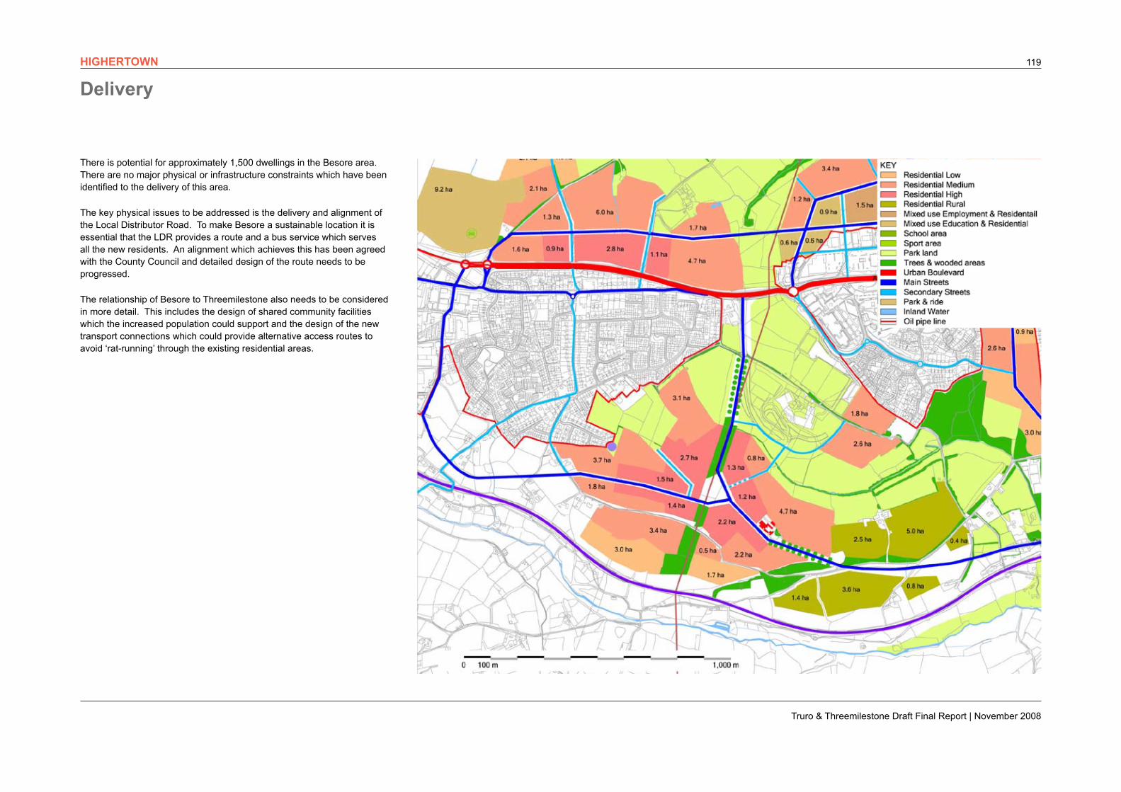
There is potential for approximately 1,500 dwellings in the Besore area. There are no major physical or infrastructure constraints which have been identified to the delivery of this area.
The key physical issues to be addressed is the delivery and alignment of the Local Distributor Road. To make Besore a sustainable location it is essential that the LDR provides a route and a bus service which serves all the new residents. An alignment which achieves this has been agreed with the County Council and detailed design of the route needs to be progressed.
The relationship of Besore to Threemilestone also needs to be considered in more detail. This includes the design of shared community facilities which the increased population could support and the design of the new transport connections which could provide alternative access routes to avoid ‘rat-running’ through the existing residential areas.
HIGHERTOWN

Truro & Threemilestone Draft Final Report | November 2008
120
Truro & Threemilestone Draft Final Report | November 2008
121
Longer Term Growth
Development on the city fringes has been identified as having an unacceptable impact on the landscape setting of the city. Further development on the Highertown Ridge would also be unacceptable. Any longer term growth would therefore need to look beyond these areas.
This in turn means that in order to create sustainable communities, development will need to be of a significant scale in order to support local shops and community facilities, and to support investment in public transport infrastructure. It is anticipated therefore that they will need to be located on major arterial routes into the city.
Given the constraints which exist on the Falmouth Road, the major areas of search are likely to be the north, east and west of the Truro & Threemilestone. These areas are all sensitive locations and have not been considered in detail within this report as more sustainable locations have been identified to meet current requirements. If they are considered unacceptable locations for new development, then it is anticipated that development would need to be concentrated in other centres in Cornwall well connected to the city by rail and bus links.
Highertown Ridge and The Modern City
At the heart of the Highertown Ridge is the ‘Modern City’ at Treliske. Building on the strengths of Royal Cornwall Hospital, Truro College and the Medi-Park proposals, the area is well placed to attract high quality jobs in the ‘knowledge economy’ which will complement the city centre. Together with the district centre and the associated leisure facilities, the area will be a vibrant mixed-use centre which will act as a focus for the surrounding communities and as a modern gateway to Truro from the west.
The masterplan creates a series of sustainable communities, supported by local centres, with good access to jobs, facilities and the countryside and with bus routes providing access to all major employment centres. Each of these communities is associated with an element of new transport infrastructure which will address traffic congestion on the A390 and promote sustainable travel.
The river valleys define the long term boundaries of growth north and south of the Highertown Ridge. The Landscape Framework identifies potential for development north and south of the Highertown Ridge, within these boundaries. Any further, significant, development capacity within these boundaries would have an unacceptable impact on the landscape setting and quality of the natural environment. It would also undermine the quality of the living and working environments which the masterplan seeks to create, and which are integral to the long term economic success of the city. The development boundaries set by the masterplan are therefore considered to be long term limits to growth.
Over the next 20 years, Truro & Threemilestone is required to deliver 6,400 new dwellings. Together, the Landscape Framework and Masterplan have identified development capacity for around 6,000 dwellings, in addition to substantial potential for office development, growth in the education, health and ‘knowledge’ sectors, improvement of industrial estates and growth in retail and leisure provision. The residential capacity does not include detailed assessments of urban capacity on smaller brownfield sites within the urban area.
The masterplan and the landscape framework have also identified certain core principles which define the long term development of Truro & Threemilestone. A fundamental principle has been to protect the core landscape features which define the historic setting of Truro, which create the high quality setting for new development and which are at the heart of a long term sustainable strategy for growth.
These development principles ensure that the Area Action Plan will be robust enough to protect the built and natural environment which makes the city such an attractive place to live, work and visit. They also ensure that the masterplan is robust enough to deal with the uncertainty which currently exist over long term economic projections and housing delivery.
Given the importance of the landscape setting and the historic built environment, it is appropriate to consider whether there is further development capacity within the Truro & Threemilestone Area, and if further growth is required where the next Areas of Search are likely to be.
Truro Bowl and The Historic City
The landscape framework identifies the key ridges that define the ‘Truro Bowl’ and setting of the city. The masterplan concept retains the series of green ridges which characterise views from within the city. In particular it retains the green hills which frame the iconic views along the estuary and to the cathedral from Boscawen Park. This concept is considered central to the landscape setting of the city. and it is not anticipated therefore that subsequent development would be permitted to undermine this. The defined landscape boundary to the city is therefore considered to be a long term limit to growth.
VII. DELIVERING THE MASTERPLAN
Truro & Threemilestone Draft Final Report | November 2008
122 DELIVERING THE MASTERPLAN
39Truro Landscape Strategy
2B.1
2B.3
4A
4B
4C
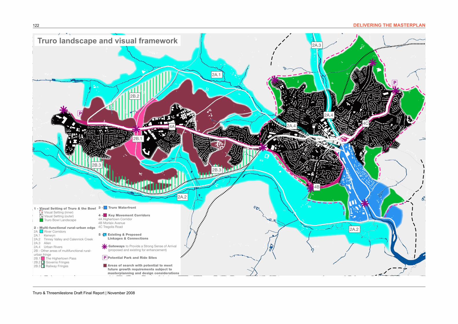
TRURO LANDSCAPE AND VISUAL FRAMEWORK
2B.3
2B.2
2A.1
2A.2
2A.2
2A.3
2A.4
2A.4
1 - Visual Setting of Truro & the Bowl Visual Setting (inner) Visual Setting (outer) Truro Bowl Landscape 2 - Multi-functional rural-urban edge2A River Corridors2A.1 Kenwyn2A.2 Tinney Valley and Calennick Creek2A.3 Allen2A.4 Urban Rivers2B - Other areas of multifunctional rural-urban fringe2B.1 The Highertown Pass2B.2 Governs Fringes2B.3 Railway Fringes
3 - Truro Waterfront 4 - Key Movement Corridors 4A Highertown Corridor 4B Morlaix Avenue 4C Tregolis Road
5 - Existing & Proposed Linkages & Connections
Gateways to Provide a Strong Sense of Arrival (proposed and existing for enhancement)
Potential Park and Ride Sites
Areas of search with potential to meet future growth requirements subject to masterplanning and design considerations
ü
ü
ü
© C
row
n co
pyri
ght,
All
righ
ts r
eser
ved
. 200
4 Li
cens
e nu
mb
er 1
0002
3554
Truro landscape and visual framework
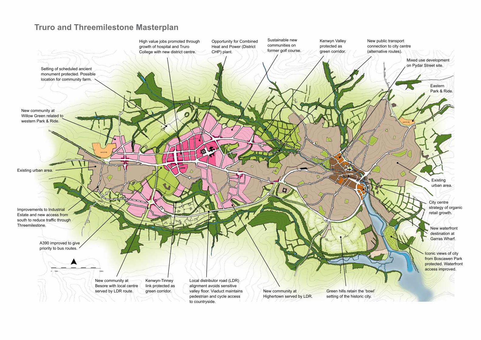
High value jobs promoted through growth of hospital and Truro College with new district centre.
Sustainable new communities on former golf course.
Kenwyn Valley protected as green corridor.
New public transport connection to city centre (alternative routes).
Mixed use development on Pydar Street site.
City centre strategy of organic retail growth.
Eastern Park & Ride.
New waterfront destination at Garras Wharf.
Iconic views of city from Boscawen Park protected. Waterfront access improved.
Green hills retain the ‘bowl’ setting of the historic city.
New community at Highertown served by LDR.
Local distributor road (LDR)alignment avoids sensitive valley floor. Viaduct maintains pedestrian and cycle access to countryside.
Kenwyn-Tinney link protected as green corridor.
New community at Besore with local centre served by LDR route.
A390 improved to give priority to bus routes.
Improvements to Industrial Estate and new access from south to reduce traffic through Threemilestone.
Existing urban area.
New community at Willow Green related to western Park & Ride.
Setting of scheduled ancient monument protected. Possible location for community farm.
Opportunity for Combined Heat and Power (District CHP) plant.
Existing urban area.
Truro and Threemilestone Masterplan
Truro & Threemilestone Draft Final Report | November 2008
124
Delivery and Phasing
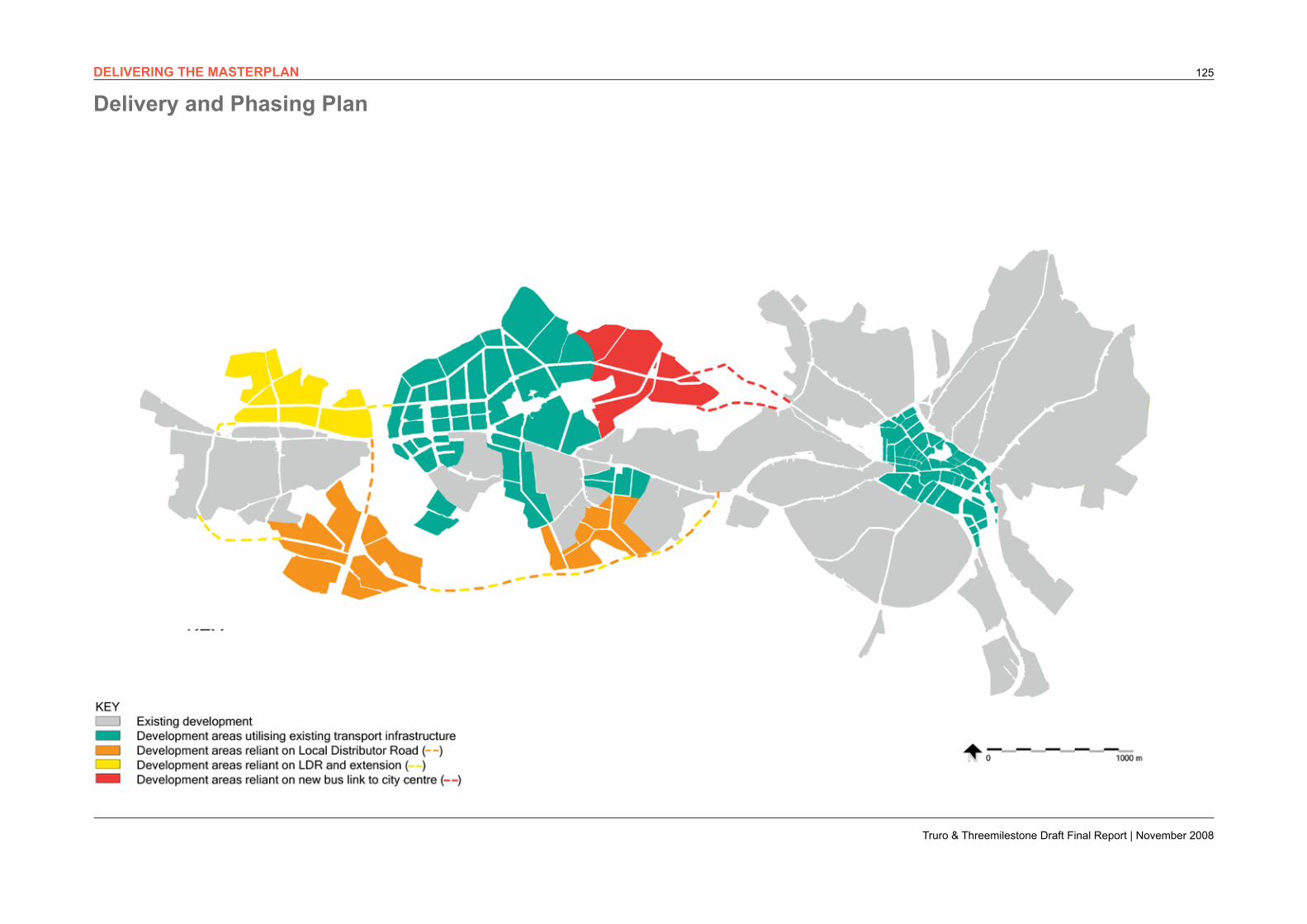
Besore
The Besore proposals build on the accessibility created by the LDR and create a critical mass of development that can support a new local centre. The area is close to existing primary and secondary schools, to employment at Treliske and Threemilestone Industrial Estate and to associated leisure and health facilities and the future district centre. Appropriate design of the LDR will ensure that bus routes, cycle routes and pedestrian routes connect the residents to Treliske, Truro City Centre and ideally to Threemilestone Industrial Estate.
The scale of housing development will also help to deliver funding for the LDR. Given that the LDR is a pre-requisite for major new development, Besore is likely to be an early phase of development.
Willow Green
The Willow Green proposals have access to the jobs at Threemilestone Industrial Estate and the local centre in Threemilestone. They will also have access to jobs, local schools, shops, leisure and health facilities in Treliske. The opening of the park & ride provides residents with access to a frequent bus service to the main employment centres and other facilities at Treliske, County Hall and Truro City Centre.
The introduction of the LDR will allow for improvements to the A390, including better pedestrian crossings to connect Willow Green to Threemilestone. A new link to Treliske will also ensure that Willow Green does not become an isolated cul-de-sac. The scale of development at Willow Green can help fund this infrastructure and phasing of development is likely to follow the improvements to the A390.
Gloweth & Treliske
Gloweth & Treliske is the main location for employment growth outside the city centre. This recognises the key roles of Royal Cornwall Hospital and Truro College in stimulating growth in the ‘knowledge economy’, and the identified potential for additional retail facilities.
Residential development is an integral element of the strategy for attracting high quality employment and creating a sustainable community with a mix of uses. Student accommodation, key worker housing and family housing, will add to the vibrancy of this area, enhance the range of facilities within the district centre and help improve the quality of the employment uses. New housing will be within easy reach of schools and new bus routes as well as jobs, shops, leisure and health facilities in both Treliske and Truro City Centre.
Gloweth & Treliske is therefore the priority area for new development outside of the city centre. Development of the existing golf course is however dependent on securing a new location for the golf club and on securing the new bus link to the city centre to avoid undue reliance on the car. The golf course is therefore likely to comprise a later phase of development.
Highertown (South of A390)
The Persimmon site (change name) already has planning permission and the former Richard Lander school is a brownfield site. Both areas have relatively good access to schools, jobs, shops, community facilities and existing bus routes. These two area are therefore priorities for development and should deliver new housing as a relatively early phase.
Land south of the former Richard Lander school is dependent on the introduction of new bus routes to provide sustainable access to jobs and facilities and avoid creating isolated cul-de-sac forms of development. Appropriate design of the LDR will avoid any such concerns, and delivery of the southern development areas will therefore be a relatively later phase post construction of the LDR.
The masterplan has noted five major areas of new development, focused on Truro City Centre and the Highertown Ridge. This is a major benefit as it provides flexibility and choice in the delivery and phasing of new housing, and allows time for the introduction of essential infrastructure.
There are two key elements of transport infrastructure required to enable sustainable growth to be achieved. To the south of the A390 the Local Distributor Road (LDR) has been identified by the County Council as essential to relieve traffic from the A390 and introduce bus priority measures. To the north of the A390, the masterplan has identified the need for a bus link between the Treliske and Truro City Centre in order to facilitate the scale of housing growth proposed to the east of the hospital.
Truro City Centre
The city centre remains the focus for retail, leisure and office development. Most development sites, and in particular Pydar Street and Garras Wharf, are appropriate for a mix of uses, including residential. This mix of uses is essential to maintain the character and vibrancy of the historic city centre, and delivering this mix is an absolute priority for the masterplan.
An ‘organic’ strategy is proposed for economic growth in the city centre, with a mixed-use approach to key development opportunities. This is flexible and robust, enhances the historic core, opens up the waterfront, supports existing businesses and maximises the development potential of both Pydar Street and Garras Wharf development sites. The organic strategy allows for flexible phasing of development and does not depend on the critical mass of new development generated by a department store. development can therefore proceed on a site by site basis within the context of a comprehensive framework and funding strategy.
Highertown Ridge
The Highertown Ridge is the focus for expansion of the urban area, and for the majority of residential growth. It can be considered in four main areas:
• Gloweth & Treliske
• Highertown (South of A390)
• Besore; and
• Willow Green
DELIVERING THE MASTERPLAN
Truro & Threemilestone Draft Final Report | November 2008
125DELIVERING THE MASTERPLAN
Delivery and Phasing Plan