Embed Size (px)
Citation preview
ELKREsouRCES, INC
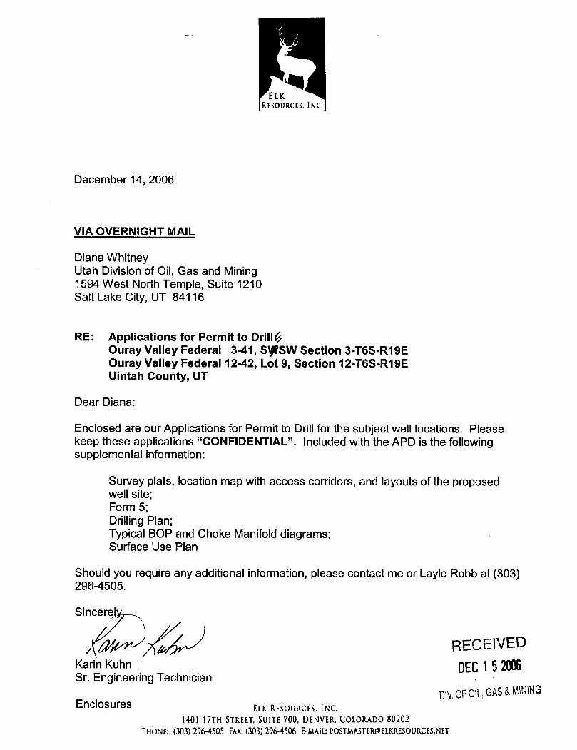
December 14, 2006
VIA OVERNIGHT MAIL
Diana WhitneyUtah Division of Oil, Gas and Mining1594 West North Temple, Suite 1210Salt Lake City, UT 84116
RE: Applications for Permit to DrilIÚOuray Valley Federal 3-41, SgSW Section 3-T6S-R19EOuray Valley Federal 12-42, Lot 9, Section 12-T6S-R19EUintah County, UT
Dear Diana:
Enclosed are our Applications for Permit to Drillfor the subject well locations. Pleasekeep these applications "CONFIDENTIAL". Included with the APD is the followingsupplemental information:
Survey plats, location map with access corridors, and layouts of the proposedwell site;Form 5;Drilling Plan;Typical BOP and Choke Manifolddiagrams;Surface Use Plan
Should you require any additional information, please contact me or Layle Robb at (303)296-4505.
Sincere
/ RECEIVEDKarin Kuhn DEC1 52006Sr. Engineering Technician
EnclosureS ELK RESOURCES, INC.D\YOFOlL,GAS&MINING
1401 17TH STREET, SUITE700, DENVER, COLORADO80202PHONE: (303)296-4505FAX:(303)296-4506E-MAIL:
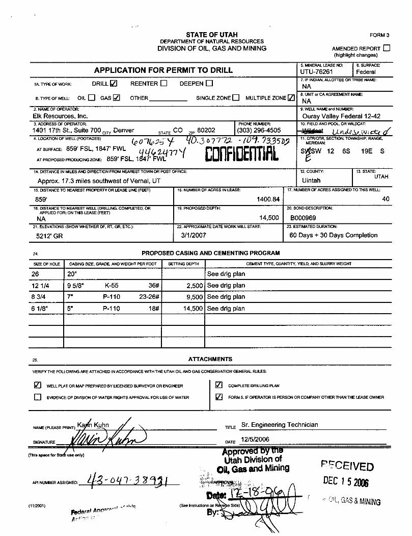
STATE OF UTAH FORM 3DEPARTMENTOF NATURALRESOURCES
DIVISIONOF OIL,GAS AND MINING AMENDEDREPORT(highlight changes)
5. MINERALLEASE NO: 6. SURFACE:APPLICATION FOR PERMIT TO DRILL UTU-76261 Federal
7. IF INDIAN,ALLOTTEEOR TRIBE NAME:1A.TYPEOFWORK: DRILL REENTER O DEEPEN NA
8. UNITor CA AGREEMENTNAME:B.TYPEOFWELL: OIL O GAS OTHER SINGLE ZONE MULTIPLEZONE NA
2. NAMEOF OPERATOR 9. WELL NAMEand NUMBER
Elk Resources, Inc. Ouray Valley Federal 12-423. ADDRESS OF OPERATOR PHONE NUMBER 10. FIELDANDPOOL, OR WILDCAT:
1401 17th St., Suite 700 crry Denver STATE CO z,, 80202 (303) 296-4505 m gy4. LOCATION OF WELL (FOOTAGES) 11.M TR, SECTION, TOWNSHIP, RANGE,
AT SURFACE: 859' FSL, 1847' FWL qq gg p S SW 12 6S 19E SATPROPOSEDPRODUCINGZONE: 859' FSL, 1847' FWL t.I as
14. DISTANCEIN MILESAND DIRECTIONFROM NEAREST TOWN OR POST OFFICE 12. COUNTY: 13. STATE:
Approx. 17.3 miles southwest of Vernal, UT Uintah UTAH
15. DISTANCETO NEAREST PROPERTY OR LEASE UNE (FEET) 16. NUMBEROF ACRES IN LEASE: 17. NJMBER OF ACRES ASSIGNED TO THIS WELL
859' 1400.84 4018. DISTANCETO NEAREST WELL(DRILLING,COMPLETED, OR 19. PROPOSED DEPTH: 20. BOND DESCRIPTION:
APPLIED FOR) ON THIS LEASE (FEET)
NA 14,500 BOOO96921. ELEVATIONS(SHOW WHETHER DF, RT, GR, ETC.): 22. APPROXIMATEDATEWORK WILLSTART: 23. ESTIMATEDDURATION:
5212' GR 3/1/2007 60 Days + 30 Days Completion
24. PROPOSED CASING AND CEMENTINGPROGRAM
SIZE OF HOLE CASING SIZE, GRADE,ANDWEIGHT PER FOOT SETTING DEPTH CEMENT TYPE, QUANTITY,YlELD,ANDSLURRYWEIGHT
26 20" See drlg plan
12 1/4 9 5/8" K-55 36# 2,500 See drlg plan
8 3/4 7" P-110 23-26# 9,500 See drlg plan
6 1/8" 5" P-110 18# 14,500 See drlg plan
25. ATTACHMENTS
VERIFYTHE FOLLOWINGARE ATTACHEDINACCORDANCEWITHTHE UTAH OIL ANDGAS CONSERVATIONGENERAL RULES:
WELLPLATOR MAP PREPARED BY LICENSED SURVEYOR OR ENGINEER COMPLETE DRILLINGPLAN
[¯]EVIDENCEOF DIVISIONOF WATER RIGHTS APPROVAL FOR USE OF WATER FORM 5, IF OPERATOR IS PERSON OR COMPANYOTHER THAN THE LEASE OWNER
NAME SE PR TO
T 12
5EnOgineeringTechnician
(This space for Sta use only) ApprovedbytheUtah Divisionof
011,Gasand Mining RECElVEDAPI NUMBERASSIGNED: 3 2 ¶ l DEC15
....1------
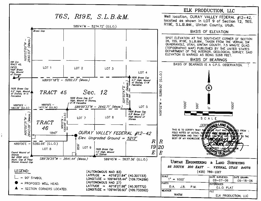
ELK PRODUCTION, LLCT6S Ri9E, S. L.B. &M Well location, OURAY VALLEY FEDERAL #12-42,
locoted as shown in LOT 9 of Section 12, T6S,S89°41'W
- 5274.72' (G.L.O.) R19E, S.L.B.&M., Uintah County, Utah.A L,,,,, e, | | BASIS OF ELEVATION
SPOT ELEVATIONAT THE SOUTHEAST CORNER OF SECTION26, T5S, R19E, S.L.B.&M., TAKEN FROM THE VERNALSWQUADRANGLE,UTAH, UINTAH COUNTY, 7.5 MINUTEQUAD.(TOPOGRAPHIC MAP) PUBLISHED BY THE UNITED STATESDEPARTMENTOF THE INTERIOR, GEOLOGICALSURVEY. SAIDELEVATIONIS MARKEDAS BEING 5268 FEET.
BASIS OF BEARINGSNW cor. NBASIS OF BEARINGS IS A G.P.S. OBSERVATION. I7RACT 45,
(AP2), LOT 1 LOT 2 LOT 31926 BrassLOT 4Cop, Mound
Oof Ston s... - - 1926 Brass Cap
89 01'18"E - 5282.23' (Meas.) ,7 High Mound
o Fenceline bNg o N1926 Brass Cap A N."2,*,,""/« TRACT 45 Sec. 12Fenceline
1926 Brass Cap 0.7'High, Mound of Stones, b oE-W Fenceline O E ONS9¶O'E - NB WTG.LO.
SB9'00'JJ"W - 2642.71' (Meas.) LOT 5 2 ° b 21162.26' (G.L.O.) 1477.74' ( )- .....- -
1926 Bross cop - I-I-0.5' Be/ow 25'
-! LOT 7 LOT 6 g *©¤¤df SC A LE
a TRACT ol---- CERR 4 6 ° \ THIS IS TO CERTIFYTHAT T PLAT WAS D FROM \1847' OURAY VALLEYTEDERAL /'12-42 "s'u¶,NOS AFNDAC ALT
E IST 0 THEE/ev. Ungraded Ground = 5212' BEST OF MY KNOWLEDGE.
N89 OO'E - 5280.66' (G.L.O.)LOT 9 19 20 ED LAN UR RLOT 8 00 1926 Brass Cap
.g1.0' High, Mound E E s A e+Found Mound ofof Stones fill
p,., SB9°39'25"W- 2641.44' (Meas.) S89°45'W
- 2637.36' (G.L.O.)UINTMI ENGINEERING & LAND SURVEYINGStones Around Cap
85 SOUTH 200 ßAST - VERNAL, UTAH 84078LEGEND: (AUTONOMOUSNAD 83) (435) 789-1017
LATITUDE= 4018'27.84" (40.307733) SCALE DATE SURVEYED: DATE DRAWN:=90° SYMBOL LONGITUDE= 109°44'03.44" (109.734289) 1" =
1000°09-07-06 09-16-06
(AUTONOMOUSNAD27) PARTY REFERENCES= PROPOSED WELL HEAD.LATITUDE = 40°18'27.98" (40.307772) D.A. J.B. P.M. G.L.O. PLATA = SECTION CORNERS LOCATED. LONGITUDE= 109'44'00.93" (109.733592) WEATHER FILE
WARM ELK PRODUCTION,

DRILLING PLAN
Elk Resources, Inc.Ouray Valley Federal 12-42
Lot 9 of Section 12, T-6-S, R-19-E, SLB&MUintah County, Utah
1,2,3 Estimated Tops of Geological Markers and Formations Expected to Contain Water, Oil andGas and Other Minerals
Formation MUinta (Possible pay intervals) 1190'*Green River 5395'*Wasatch 9065'*Mesaverde 12140'*Proposed TD 14500'
PROSPECTIVE PAY* oil and gas
4 Casing ProgramHOLE SETTING DEPTHSIZE from SIZE WEIGHT GRADE THREAD COND.26" surface 50-75' 20"12 ¼" surface 2,500' 9 5/8" 36# K-55 ST&C New8 ¾" surface 9,500' 7" 23-26# P-110 LT&C New6 1/8" 9,200' TD' 5" 18# P-110 UFJ New
In the event a liner seal mechanism is used, the seal will be tested by a fluid entry and pressure testto maximum pressure anticipated (80% of joint strength maximum).
As per 43 CFR 3160, Onshore Oil and Gas Order No. 2, Drilling Operations, Part B-1-b.
5 Cementing Program (Actual cement volumes will be calculated from caliper logs when possible)
20" Conductor Ready mix
9 5/8" Lead: 660 sx Prem HLC + ¼ pps Flocele + 1% CaCl; 12.8 ppg, 1.8 cf/sk(100% excess)Tail: 165 sx Prem V + ¼ pps Flocele + 2% CaCl; 15.8 ppg, 1.16 cf/sk
7" Stage 1: 365 sx 50/50 Poz + 2% gel + 6% Halad-322 + 1 pps Granulite +5% salt + ¼ pps Flocele; 14.4 ppg, 1.41 cf/sk (no excess)
000f
Elk Resources, Inc.Drilling ProgramOuray Valley Federal 12-42Uintah County, UtahPage 2
DV TOOL Stage 2: Lead 150 sx HiFill + 16% gel + 0.75% Econolite + 7.5 ppg@5800' gilsonite + ¼ Flocele; 11.0 ppg, 3.81 ef/sx (100% excess).
Stage 2: Tail 275 sx 50/50 Poz + 2% gel + 6% Halad-322 + 1 ppsGranulate + 5% salt + ¼ pps Flocele; 14.4 ppg, 1.41 cf/sk.
5" 312 sx 50/50 Poz 2% gel + 0.3% CFR-3 + 0.15% HR+12 + 20% SSA-1 +0.4% Halad-344; 14.35 ppg, 1.41 cf/sk (35% excess)
6 Mud Program
Elk Production, LLC will record slow pump speed on daily drilling report after mudding up.
Elk shall use electronic/mechanical mud monitoring equipment, which shall include a pit volumetotalizer (PVT); stroke counter; and flow sensor.
A mud test will be performed at least every 24 hours after mudding up to determine density,viscosity, gel strength, filtration, and pH.
Gas-detecting equipment will be installed and operated in the mud-return system.
A flare system will be used that gathers and burns all gas. The flare line(s) shall discharge at least100 feet from the well head with straight lines and shall be positioned downwind of the prevailingwind direction and shall be anchored.
A mud-gas separator (gasbuster) shall be used from surface casing to TD.
As per 43 CFR 3160, Onshore Oil and Gas Order No. 2, Drilling Operations, C. Mud Program Requirements.
INTERVAL WEIGHT VISCOSITY FLUID LOSS REMARKSSurf. - 880' N/A Water
880 -4500' 8.4 / 8.6 ppg 32 NC Spud Mud4500 - 9500' 8.4 / 9.0 ppg 28 NC KCL Water/Gel9500 - 14500' 9.0/12.0 ppg 34 10 KCL/Gel/Polymer
7 BOP and Pressure Containment Data
Depth Intervals BOP EquipmentSurf. - 1000' None1000' - 10,000' 10,000# Ram type double BOP and annular10,000' - 14,500' 10,000# Ram type double BOP and 10,000# annular
Estimated bottom hole pressure at TD will be 9050 psi. Drilling spool to accommodate choke andkill lines.
Elk Resources, Inc.Drilling ProgramOuray Valley Federal 12-42Uintah County, UtahPage 3
ANCILLARY EQUIPMENT AND CHOKE MANIFOLD RATED AT 5,000# MINIMUM.ALL BOP AND BOPE TESTS WILL BE IN ACCORDANCE WITH THE REQUIREMENTSOF THE BUREAU OF LAND MANAGEMENT.
THE STATE OF UTAH, DIVISION OF OIL, GAS AND MINING WILL BE NOTIFIED 24HOURS IN ADVANCE OF ALL BOP PRESSURE TESTS. THE BUREAU OF LANDMANAGEMENT WILL BE NOTIFIED 24 HOURS IN ADVANCE OF ALL BOPE PRESSURETESTS.
8 Auxiliary eguipmenta) Upper and Lower Kelly cockb) Floor stabbing valve 5000#c) Safety valve(s) and subs to fit all string connections in use
9 Testing, Logging and Core ProgramsCores None anticipatedTesting None anticipatedSampling 10' samples; surface casing to TD.Surveys Run every 1000' and on tripsLogging Resistivity, neutron density, and caliper from TD to surface casing. Gamma ray
from TD to surface
10 Anticipated Abnormal Pressures or TemperaturesNone anticipated.
11 Drilling ScheduleSpud Approximately March 1, 2007Duration 30 days drilling time
30 days completion time
HAZARDOUS MATERIAL DECLARATION
Ouray Valley Federal 12-42
Elk Resources, Inc. guarantees that during the drilling and completion of the above referencedwell, we will not use, produce, or store, transport or dispose 10,000# annually of any of thehazardous chemicals contained in the Environmental Protection Agency's consolidated list ofchemicals subject to reporting under Title III Super Amendments and Reauthorization Act(SARA) of 1986.
Elk Resources, Inc. guarantees that during the drilling and completion of the above referencedwell, we will use, produce, store, transport, or dispose less than the threshold planning quantity(TPQ)of any extremely hazardous substances as defined in 40 CFR 355.
COlfilER
TYPICAL BLOWOUT PREVENTER
ROTARY
7 1/16" 10M BOP STACK
ANNULAR
10M
10M PIPE RAMo a
10M BLINDRAM
DRILLINGSPOOL
10M PIPE
CH0KEMANIFOLDHydraulic
CHOKE.
. 5.
TOFLAREPIT&/0R SEPARATOR3"
T0 PITBBP STACK
OUTLET
ADJUSTABLE TOMUDPITCHOKE
Surface Use PlanAttachment to Permit to DrillOuray Valley Federal 12-42Page 1
SURFACE USE PLAN
Ouray Valley Federal 12-42
Attachment to Permit to Drill
The dirt contractor will be provided with an approved copy of the surface use plan ofoperations before initiating construction.
The onsite inspection for the referenced well is pending with the Division of Oil, Gas andMining and the landowner:
1. Existing Roads:
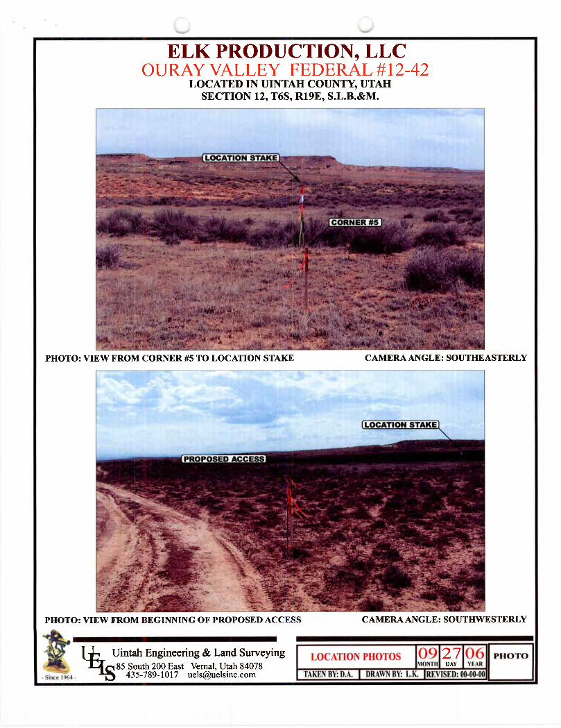
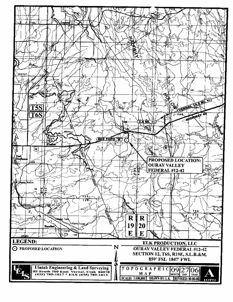
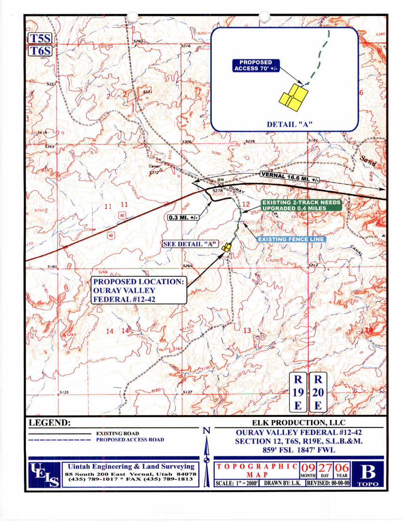
a. The proposed well site is located approximately 17.3 miles Southwesterlyof Vemal, Utah.
b. The following are directions to the proposed well site:Proceed in a Southwesterly direction from Vernal, Utah along U.S.Highway 40 approximately 16.6 miles; make a left headingSoutheasterly, then Northeasterly, then Southwesterly for 0.7 mileson the existing 2-track dirt road; then head slightlySouthwesterly70 feet to the location. See attached plat.
c. The use of roads under Federal, State and County Road Departmentmaintenance are necessary to access the Ouray Valley Federal 12-42location. All existing roads will be maintained and kept in good repairduring all phases of operation.
d. Vehicle operators willobey posted speed restrictions and observe safespeeds commensurate with road and weather conditions.
e. Since no improvements are anticipated to the State, County, or BLMaccess roads, no topsoilstriping will occur.
2. Planned Access Roads:a. From the existing surface road, a new access is proposed trending
southeastery, then southerly and then southwesterly approximately 0.7miles to the proposed well site. The access consists of entirely newdisturbance across previously cultivated ground and crosses no significantdrainages.
b. The proposed access road crosses surface owned by the United States ofAmerica, clo Bureau of Land Management.
c. The proposed access road willconsist of a 14' travelsurface within a 30'disturbed
Surface Use PlanAttachment to Permit to DrillOuray Valley Federal 12-42Page 2
d. A maximum grade of 4% willbe maintained throughoutthe project with nocuts and fills required to access the well.
e. No turnoutsare proposed; adequate site distance exists in all directions.f. No low water crossings are anticipated. Adequate drainage structures will
be incorporated into the road.g. No surfacing material will come from Federal or SITLA lands.h. Surface disturbance and vehicular travelwill be limited to the approved
location access road.i. AIIaccess roads and surface disturbing activities will conform to the
standards outlined in the pending fee surface use agreement.j. The operator will be responsible for all maintenance of the access road
including drainage structures.
3. Location of Existing Wells:a. Attached is a map reflecting a one-mile radius of the proposed well. There
is one plugged and abandoned well and no producing wells within thisradius.
4. Location of Production Facilities:a. AIIpermanent structures willbe painted a flat, non-reflective Desert Brown
to match the standard environmental colors. AIIfacilities will be paintedwithin six month of installation. Facilities are required to comply with theOccupational Safety and Health Act (OSHA) may be excluded.
b. If productive, a gas meter run will be constructed and located on leasewithin 500 feet of the wellhead. Meter runs willbe housed and/or fenced.AIIgas production and measurement shall comply with the provisions of43 CFR 3162. 7-3, Onshore Oiland Gas Order No. 5, and American GasAssociation (AGA) Report No. 3.
c. If productive, a tank battery will be constructed on this lease, it will besurrounded by a dike of sufficientcapacity to contain the storage capacityof the largest tank. AIIloading lines and valves willbe placed inside theberm surrounding the tank battery. AIIliquid hydrocarbons production andmeasurement shall conform to the provisions of 43 CFR 3162.7-3 andOnshore Oiland Gas Order No. 4 and Onshore Oil and Gas Order No. 5for oil and natural gas production and measurement.
d. Any necessary pits will be properly fenced to prevent any wildlife andlivestock entry.
e. AIIaccess roads will be maintained as necessary to prevent erosion andaccommodate year-round traffic. The road will be maintained in a safeuseable condition.
f. The site will require periodic maintenance to ensure that drainages arekept open and free of debris, ice, and snow, and that surfaces are properlytreated to reduce erosion, fugitive dust, and impacts to adjacent areas.
Surface Use PlanAttachment to Permit to DrillOuray Valley Federal 12-42Page 3
5. Location and Type of Water:a. Water for construction and drilling has been obtained througha direct
purchase agreement with a municipality.
6. Source of Construction Material:a. No construction materials will be removed from Ute Tribal, SITLA or BLM
lands.b. Ifany gravel is used, it willbe obtained from a State-approved gravel pit.
7. Methods of Handlinq Waste Disposal:a. AIIwastes associated with this application willbe contained and disposed
of utilizingapproved facilities.b. Drillcuttings willbe contained and buried onsite.c. The reserve pit willbe located outboard of the location and along the
northwest side of the pad.d. The reserve pit willbe constructed so as not to leak, break, or allow any
discharge.e. The reserve pit will be lined with 12-mil minimum thickness plastic nylon-
reinforced liner material. The liner will overlay a felt pad only if rock isencountered during excavation. The pit liner will overlap the pit walls andbe covered with dirt and/or rocks to hold it in place. No trash, scrap pipe,etc., that could puncture the liner will be disposed of in the pit. Pit wallswill be sloped no greater than 2:1. A minimum2-foot freeboard will bemaintained in the pit at all times during the drillingand completionoperation.
f. The reserve pit has been located in cut material. Three sides of thereserve pit will be fenced before drillingstarts. The fourth side willbefenced as soon as drilling is completed, and shall remain until the pit isdry. After the reserve pit has dried, all areas not needed for productionwillbe rehabilitated.
g. Trash will be contained in a trash cage and hauled away to an approveddisposal site as necessary but no later than at the completion of drillingoperations. The contents of the trash container will be hauled offperiodically to the approved Uintah County Landfill near Vernal, Utah.
h. Produced fluids from the well other than water will be produced into a testtank until such timeas construction of production facilities is completed.Any spills of oil, gas, saltwater or other produced fluids willbe cleaned upand removed.
i. Any salts and/or chemicals, which are an integral part of the drillingsystem, willbe disposed of in the same manner as the drilling fluid.
j. Sanitary facilitieswill be onsite at all times during operations. Sewage willbe placed in a portable chemical toiletand the toiletreplaced periodicallyutilizinga licensed contractor to transport by truckthe portable chemicaltoiletso that its contents can be delivered to the Vernal WastewaterTreatment Facility in accordance with State and County regulations.
Surface Use PlanAttachment to Permit to DrillOuray Valley Federal 12-42Page 4
8. Ancillary Facilities:a. Garbage containers and portable toiletsare the only ancillary facilities
proposed in this application.
9. Well Site Layout:a. The well willbe properly identified in accordance with State regulations.b. Access to the well pad will be from the south and west.c. The pad and road designs are consistent with State and Federal
specifications.d. A pre-construction meeting with responsible company representative,
contractors, landowner representatives and the Utah Division of Oil, Gasand Mining will be conducted at the project site prior to commencement ofsurface-disturbing activities. The pad and road will be construction-stakedprior to this meeting.
e. The pad has been staked at its maximum size; however, it willbeconstructed smaller if possible, depending upon rig availability. Shouldthe layout change, this application will be amended and approved utilizinga sundry notice.
f. All surface disturbing activities willbe supervised by a qualified,responsible company representative who is aware of the terms andconditions of the APD and specification in the approved plans.
g. AIIcut and fillslopes willbe such that stabilitycan be maintained for thelife of the activity.
h. The site surface will be graded to drain away from the pit to avoid pitspillage during large storm events.
i. The stockpiled topsoil(first 6 inches or maximum available) will be storedin a window on the uphillside of the location to prevent any possiblecontamination. AIItopsoilwill be stockpiled for reclamation in such a wayas to prevent soil loss and contamination.
j. Pits willremain fenced until site cleanup.k. The blooie line willbe located at least 100 feet from the well head.I. Water injection may be implemented if necessary to minimize the amount
of fugitive dust.
10. Plans for Restoration of the Surface:a. Site reclamation for a producing well willbe accomplished for portions of
the site not required for the continued operation of the well.b. The Operator willcontrol noxious weeds along access road use
authorizations, well sites, or other applicable facilities by spraying ormechanical removal. A list of noxious weeds may be obtained from theUtah Division of Oil, Gas and Mining or the appropriate County ExtensionOffice.
c. Upon well completion, any hydrocarbons in the pit shall be removed.Once the reserve pit is dry, the plastic nylon-reinforced liner shall be tornand perforated before backfilling of the reserve pit. The reserve pit and
COlf
Surface Use PlanAttachment to Permit to DrillOuray Valley Federal 12-42Page 5
that portion of the location not needed for production facilitiesloperationswill be recontoured to the approximate natural contours.
d. The cut and fillslopes and all other disturbed areas not needed for theproduction operation will be top soiled and re-vegetated. The stockpiledtopsoilwill be evenly distributed over the disturbed area.
e. Prior to reseeding the site, all disturbed areas, including the access road,willbe scarified and left with a rough surface. The site willthen be seededand/or planted as prescribed by the landowner. The landownerrecommended seed mix will be detailed within their surface-usedocuments.
11. Surface and Mineral Ownership:a. Surface Ownership: Bureau of Land Managementb. Mineral Ownership: Bureau of Land Management
12. Other Information:a. None.
Self-Certification Statement
Please be advised that Elk Resources, Inc. is considered to be theoperator of Ouray Valley Federal 12-42; Lot 9, (SESW) Section 12,Township 6 South, Range 19 East; Lease UTU-76261; UintahCounty, Utah; and is responsible under the terms and conditions ofthe lease for the operations conducted upon the leased lands.Bond coverage is provided by BLMBond #UTBOOO135."
12/05/2006Karin Kuhn, Sr. Engineering Technician Date
Surface Use PlanAttachment to Permit to DrillOuray Valley Federal 12-42Page 6
13. Operator's Representative and Certification:
I hereby certify that I, or person under my direct supervision, have inspectedthe proposed drillsite and access route; that I am familiar with the conditionswhich currently exist; that the statements made in the plan are, to the best ofmy knowledge, true and correct; and that the work associated with operationsherein will be performed by , (constructioncontractor has not been determined) and its contractors and subcontractors inconformity with this plan and the terms and conditions under which it isapproved. This statement is subject to the provisions of 18 U.S.C. 1001 forthe filing of a false statement.
Name and Titlea L. Robb, Vice President of Northern s
STATE OF COLORADO ' •.
Ñ.•gaCOUNTY OF DENVER •..
TE OŸ
Subscribed and sworn to before me this 5th day of December, 2006.
My commission Expires: O A cid49
Notary Public
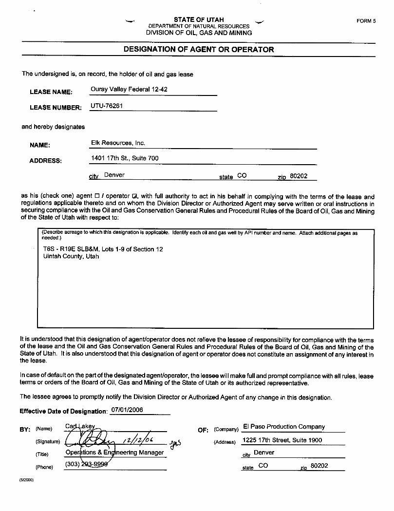
s, STATE OF UTAH FORM 5DEPARTMENT OF NATURALRESOURCES
DIVISIONOF OIL, GAS AND MINING
DESIGNATION OF AGENT OR OPERATOR
The undersigned is, on record, the holder of oil and gas lease
LEASE NAME: Ouray Valley Federal 12-42
LEASE NUMBER: UTU-76261
and hereby designates
NAME: Elk Resources, Inc.
ADDRESS: 1401 17th St., Suite 700
city Denver state CO zip 80202
as his (check one) agent O I operator 12, with full authorityto act in his behalf in complying with the terms of the lease andregulations applicable theretoand on whom the Division Director or Authorized Agent may serve writtenor oral instructions insecuring compliance with the Oiland Gas Conservation General Rules and Procedural Rules of the Board of Oil, Gas and Miningof the State of Utah with respect to:
(Describe acreage towhich this designation is applicable. Identify each oiland gas well by API number and name. Attach additionalpages asneeded.)
T6S - R19E SLB&M,Lots 1-9 of Section 12Uintah County, Utah
It is understood thatthis designation of agent/operator does not relieve the lessee of responsibility for compliance with the termsof the lease and the Oil and Gas Conservation General Rules and Procedural Rules of the Board of Oil, Gas and Mining of theState of Utah. It is also understood that thisdesignation of agent or operator does not constitute an assignment of any interest inthe lease.
Incase of default on thepart ofthedesignated agent/operator, the lessee willmake fulland prompt compliance with all rules, leaseterms or orders of the Board of Oil, Gas and Mining of the State of Utah or its authorized representative.
The lessee agrees to promptly notify the Division Director or Authorized Agent of any change in thisdesignation.
Effective Date of Designation: 07/01/2006
BY: (Name) Car akey- . OF: (company)El Paso Production Company
(Signature) ( / Z L (Address) 1225 17th Street, Suite 1900
(Title) Ope tions & En ineering Manager city Denver
(Phone) (303) state CO zip 80202
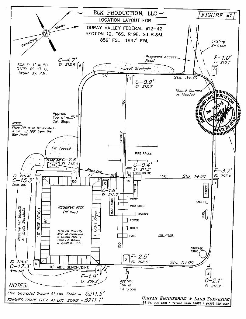
ELK PRODUCTION, LLC FIGURE #iLOCATION LAYOUT FOR
«* OURAY VALLEY FEDERAL #12-42SECTION 12, T6S, R19E, S.L.B.&M.
.go 859' FSL 1847' FWL \ Existing2- Track
Proposed Access \ E-1.0'C-4.7' Road \ B. 210.1'DSACAE:E.0 N500 B. 2158'
'Shrkpi/eDrawn By· P.M. F 75' Sto. J+307
E/. 212 O'Round Corners ggas Needed
Approx.Top ofCut SlopeN01E
Flore Pit is to be locateda min. of 100' from the
illWell Head.
Pit TopsoilPIPE RACKS
e err C-2.8 I i i1J.9' -0.4'
E/. 216.4' - 150' Sto. 1+50.. .. 10 '
--- C-1.6' !!--- 8. 212 7---- o PUW
TOILETOMUD SHEDRESERVE P/TS -----
(/0' Deep) - -
HOPPER5 -
- o - Uo o -o-
PowER
TOOLSTota/ Pit CopacityW/2' of Freeboard FUEL 0+= 15,490 Ob/s. ±
.
4 4 Total Pit Vo/ume= 4,280 Gu. Yds. ·¯¯¯
¯¯¯¯¯
---
STORAGE-----
TANK
E/. 218.4 Ma. 0+00C-17 J' 10' WIDE BENCH/DIKE2
(bim. pit)
8, 209.2' Approx. •
NO TES.Bev. Ungraded Ground At Loc. Stoke = 5211.5'
, UINTAH ENGINEERING & LAND SURVEYINGRN/SHED GRADE REW AT LOC. STAKE =5211.1 as s.. 2,o ,,,, . v,,,,,, e,,, ,,oy,
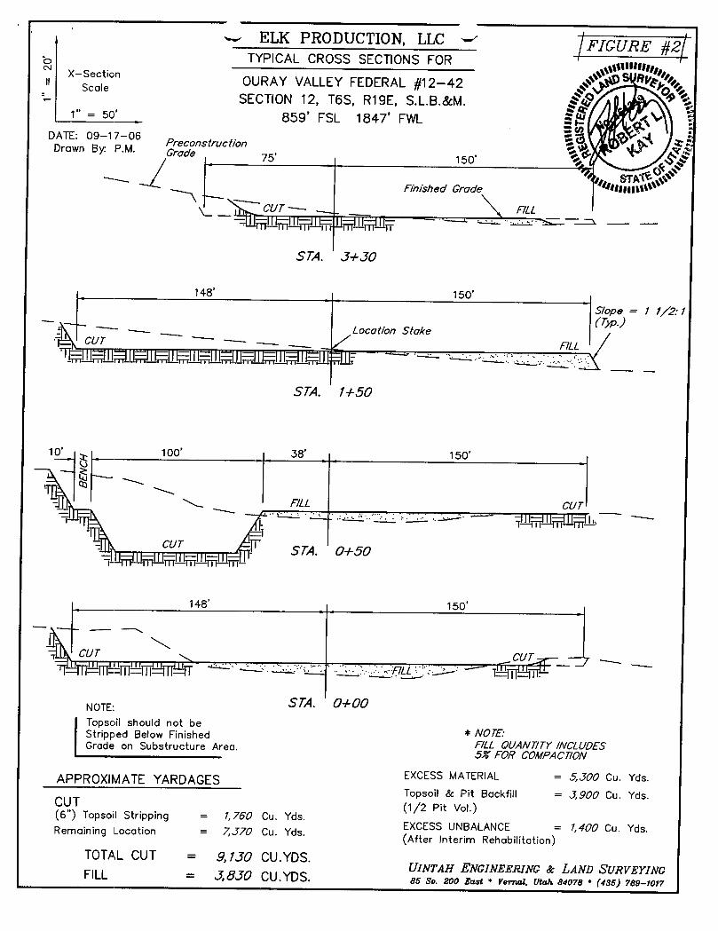
ELK PRODUCTION, LLC 'FIGURE #2
TYPICAL CROSS SECTIONS FOR sm×-sectionOURAY VALLEY FEDERAL #12-42scale
SECTION 12, T6S, R19E, S.L.B.&M.1" = 50' 859' FSL 1847' FWL
DATE: 09-17-06-PreconstructionDrawn By· P.M ade 75' 150°
~
Einished Grade
STA. J+JO
148' 150'
S/ope = 1 1/2 1
STA. 1+50
10 100' 38' 150'
148' 150'
NOTE:Topsoil should not beStripped Below Finished * NOTE:Grade on Substructure Area. E/LL QUANT/TY/NCLUDES
5% EOR COMPACT/0N
APPROXIMATEYARDAGES EXCESS MATERIAL = 5,JOO Cu. Yds.Topsoil & Pit Backfill = J,900 Cu. Yds.CUT (1/2 Pit Vol.)(6") Topsoil Stripping = 1,760 Cu. Yds.EXCESS UNBALANCE = 1,400 Cu. Yds.Rernaining Location = 7J70 Cu. Yds.(After Interim Rehabilitation)
TOTAL CUT = 9,1]O CU.YDS.UINTAH ENGINEERING & LAND SURVEYINGFILL = J,8JO CU.YDS. es so. zoo rest • vernal. Utan asore * (4ss)
T5S
1 1
66
PROPOSED LOCATION:OURAY VALLEYFEDERAL #12-42
14 14 13
0
LEGEND: ELK PRODUCTION, LLCexisTwo noAn N OURAY VALLEY FEDERAL #12-42
----------- PROPOSED ACCESS ROAD SECTION 12, T6S, R19E, S.L.B.&M.859' FSL 1847 FWL
- Dintah Engineering & I-and Surveying TOPOGR A P II I c 09 27 0685 South 200 East VernaE, Utah 84078 Al A Ÿ MONTH DAY YEAR
(435) 789-1017 * VAX (435) 789-1813SCALE:1"= 2000' DRAWNBY:LK. REVISED:
WORKSHEETAPPLICATION FOR PERMIT TO DRILL
APD RECEIVED: 12/15/2006 API NO. ASSIGNED: 43-047-38931
WELL NAME: OURAY VLY FED 12-42
OPERATOR: ELK PRODUCTION LLC ( N2650 ) PHONE NUMBER: 303-296-4505
CONTACT: KARIN KUHN
PROPOSED LOCATION: INSPECT LOCATN BY: / /
SESW 12 060S 190E . .
Tech Review Initials Date
SURFACE: 0859 FSL 1847 FWL
BOTTOM: 0859 FSL 1847 FWL Engineering
COUNTY: UINTAH GeologyLATITUDE: 40.30777 LONGITUDE: -109.7335
UTM SURF EASTINGS:607625 NORTHINGS: 4462477 Surface
FIELD NAME: UNDESIGNATED ( 2 )
LEASE TYPE: 1 - Federal
LEASE NUMBER: UTU-76261 PROPOSED FORMATION: MVRD
SURFACE OWNER: 1 - Federal COALBED METHANE WELL? NO
RECEIVED AND/OR REVIEWED: LOCATION AND SITING:
- Plat R649-2-3.
,-Bond: Fed[1] Ind[] Sta[] Fee[] Unit:
Po
ashBOOO9/6N9)3 R649-3-2. General
Oil Shale 190-5 (B) or 190-3 or 190-13 Siting:460 From Qtr/Qtr & 920'Between Wells
,- Water PermitR649-3-3. Exception
(No. MUNICIPAL )Drilling Unit
RDCC Review (Y/N)
(Date: )Board Cause No:Eff Date:
AJA Fee Surf Agreement (Y/N) Siting:
ALA Intent to Commingle (Y/N) ,R649-3-11. Directional Drill
COMMENTS:
STIPULATIONS: C a
BARSON-Sil VEREMPIRE i,
Ii
FEDERAL44X-35s
I A
MONADA GOVT3 0-35E190
WEST GUSHERST I-36U
LU%HER |LUhlI[R 14-36-5 19
T5S R19E _ u 36 s is
T6S Ri9E 'MONADA (.USHIR LU%iiiR
MOFFAT . stam 2-26-99 .-24-.9
CANAL FIELDARMALHg GUSHER
CAUSE: 09-42 I 4-12-1985I
MONADAGLOBE-MONADA STATE 2GOVT 4 OURAY
LUNHIR FEDERALI16-2-6-19
OURAi ill110 3-41
TKIUMPHFFDFR.M. 2
II
I
GURA% VilFED 12-42
GUSHLR6-15-6-19
OPERATOR: ELK RESOURCES INC (N2650)
SEC: 12 T.6S R. 19E
FIELD:UNDESIGNATED (002)
COUNTY: UINTAHWells Status
SPACING: R649-3-2 / GENERAL SITING,
- GAS INJECTION Utah 00 Gas a nd M aGAS STORAGE U
X LOCATION ABANDONEDNEW LOCATION N
Field Status Unit Status 4 PLUGGED & ABANDONEDABANDONED EXPLORATORY y PRODUCING GASACTlVE
ST LMGE e PRHOUIUNClGNAGSOIL
COMB1NFD NF SECONDARY e SHUT-IN OIL W E1 i r NODING ):( TEMP. ABANDONED
1 N TED THERMLAS NLJECTION
SPP OIL WATER SUPPLY PREPARED BY: DIANA MASONSECONDARY t WATER DISPOSAL DATE: 18-DECEMBER-2006TERMINATED .
JON M. HUNTSMAN, JR.Governor
GARY R. HERBERTx•• Lieutenant Governor
State of Utah December 18, 2006
Department ofNatural Resources
MICHAEL R. STYLERaccutiveDirec'°' Elk Resources, Inc.
Division of 1401 17th St., Ste. 700
Oil, Gas & Mining Denver, CO 80202
JOHN R. BAZADivision Director
Re: Ouray Valley Federal 12-42 Well, 859' FSL, 1847' FWL, SE SW, Sec. 12,T. 6 South, R. 19 East, Uintah County, Utah
Gentlemen:
Pursuant to the provisions and requirements of Utah Code Ann.§ 40-6-1 et seq.,Utah Administrative Code R649-3-1 et seq., and the attached Conditions of Approval,approval to drill the referenced well is granted.
This approval shall expire one year from the above date unless substantial andcontinuous operation is underway, or a request for extension is made prior to theexpiration date. The API identification number assigned to this well is 43-047-38931.
Sincerely,
Gil HuntAssociate Director
pabEnclosures
cc: Uintah County Assessor (via e-mail)Bureau of Land Management, Vernal District Office
1594 West North Temple, Suite 1210, PO Box 145801, Salt Lake City, UT 84114-5801
telephone (801) 538-5340•facsimile (801) 359-3940•TTY (801) 538-7458 •
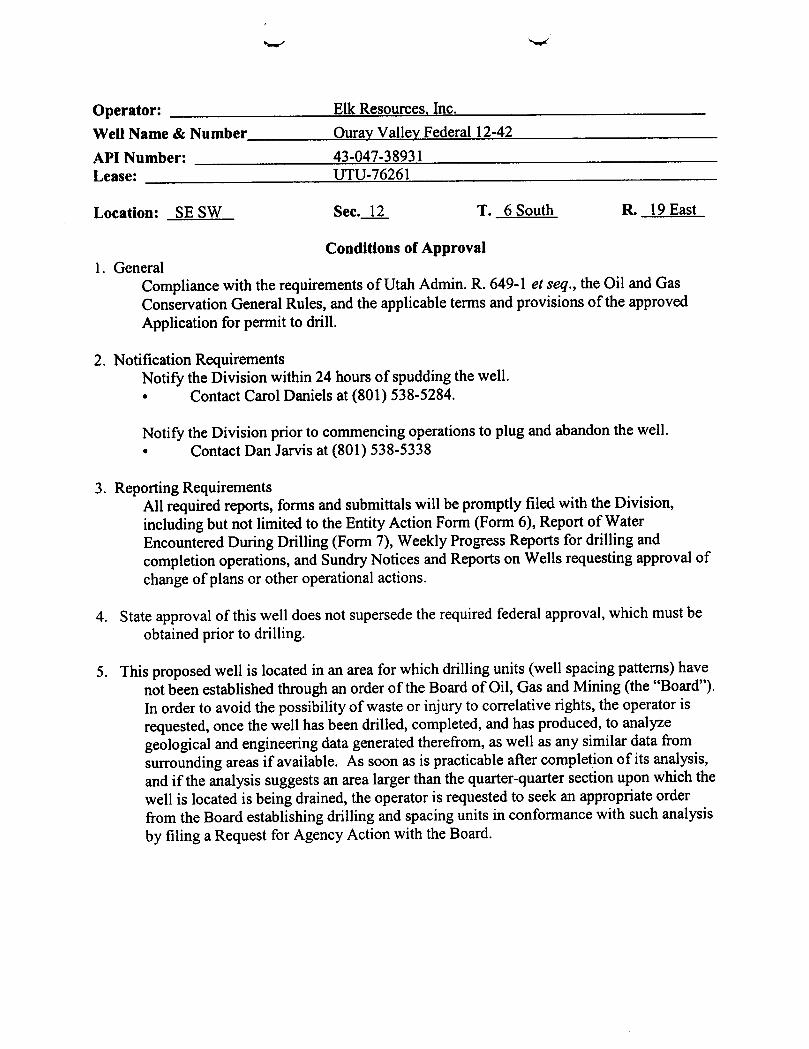
Operator: Elk Resources, Inc.Well Name & Number Ourav Valley Federal 12-42
API Number: 43-047-38931Lease: UTU-76261
Location: SE SW Sec._l_2_ T. 6 South R. 19 East
Conditions of Approval1. General
Compliance with the requirements of Utah Admin. R. 649-1 et seq., the Oil and GasConservation General Rules, and the applicable terms and provisions of the approvedApplication for permit to drill.
2. Notification RequirementsNotify the Division within 24 hours of spudding the well.• Contact Carol Daniels at (801) 538-5284.
Notify the Division prior to commencing operations to plug and abandon the well.• Contact Dan Jarvis at (801) 538-5338
3. Reporting RequirementsAll required reports, forms and submittals will be promptly filed with the Division,including but not limited to the Entity Action Form (Form 6), Report of WaterEncountered During Drilling (Form 7), Weekly Progress Reports for drilling andcompletion operations, and Sundry Notices and Reports on Wells requesting approval ofchange of plans or other operational actions.
4. State approval of this well does not supersede the required federal approval, which must beobtained prior to drilling.
5. This proposed well is located in an area for which drilling units (well spacing patterns) havenot been established through an order of the Board of Oil, Gas and Mining (the "Board").In order to avoid the possibility of waste or injury to correlative rights, the operator isrequested, once the well has been drilled, completed, and has produced, to analyzegeological and engineering data generated therefrom, as well as any similar data fromsurrounding areas if available. As soon as is practicable after completion of its analysis,and if the analysis suggests an area larger than the quarter-quarter section upon which thewell is located is being drained, the operator is requested to seek an appropriate orderfrom the Board establishing drilling and spacing units in conformance with such analysisby filing a Request for Agency Action with the
Foun 3160-5 UNITED STATES FORMAPPROVED(April2004) DEPARTMENTOF THE INTERIOR ËpM l
BUREAUOF LAND MANAGEMENT 5. LeaseScrialNo.SUNDRY NOTICES AND REPORTS ON WELLS ETU-76261
Do not use this form for proposals to dri/I or to re-enter an 6. If Indian,AllotteeorTribeNameabandoned we/I. Use Form 3760-3 (APD) for such proposals• NA
SUBMITIN TRIPLICATE- Otherinstructions on reverse side. 7. IfunitorcA/Agreement,Nameand/orNo.
1. Type ofilWell GasWell Other 8.
WNeu
Nameand No.Ouray Valley Federal 12-422. NameofOperatarElk Resources, Inc• 9. API WellNo.
3a Address 3b. PhoneNo (include mea code) 43-047-38931
1401 17th. St. Suite 700 Denver, Colorado, 80202 303-296-4505 10.FieldandPool,or ExploratoryArea4. Locationof Well (Footage,Sec.,I, R.,M, orS yr) Exploratory
SESW Section 12-T6S-R19E, SLB&M, 859' FSL, 1847' FWL l1. CountyorParish, State
Uintah, Utah
11 CHECK APPROPRIATEBOX(ES)TO INDICATENATURE OFNGHŒ, REPORT, OR OTHERDATA
TYPEOF SUBMISSION TYPEOFACTION
O Acidize Deepen Produedon (Stadesume) WaterShut-OffNoticeof Intent AlterCasmg FractuteTreat Reclamation WeßIntegray
O SubsequentReport Casing Repair NewConstruction Recomplete Other Change of Water
ChangePlans PlugandAbandon TemporarilyAbandon Source for DrillingO FinalAbandonmentNotice ConverttoInjection PlugBack WaterD
13. DescribeProposedor CompletedOperation(clearlystateallperlinentdetails,includingestimated starting dateof anyproposedwork andapproximate durationthereofIftheproposalistodeependirectionallyor recomplete horizontally,give subsurfacelocationsand measured andtruevertical depthsofallpertinentmarkers and zones.Attach theBondunder which thework will beperformedor providetheBondNo. onfilewith BLM/BIA.Requiredsubsequentreports shallbefiledwithin 30daysfollowingcompletionoftheinvolvedopemtions.If theopemtionresults ina multiplecompletion orrecompletion ina new interval,a Form3160-4shallbefiledoncetestinghasbeencompleted.FinalAbandonment Notices shallbefiledonlyafter all requirements, includingreclamation, havebeencompleted,andtheoperatorhasdeterminedthatthesite is ready forfinalinspection.)
Water for the drilling of the Ouray Valley Federal 12-42 will be pumped into tank trucks and trucked to the well site. Please see the attachedapproved Temporary Ap11ication Number 45-6177 (T77046). The source of the water is the Green River. Elk will be using a portion of theallocated amount of water for the drilling of the subject well.
14. I hereby certify thatthe oregoing is true and correctName (Printed/Typ
Kari n Title Sr. Engineering TechnicianI /
Signature 05/23/2007
THIS SPACE FOR FEDERAL OR STATE OFFICE USE
Approved ty prConditionsof approval, ifany, aæ attached. Approvalof thisnotice doesnàg at OvalUtTA
MAY29 2007DIV.0F0lL,GAS&
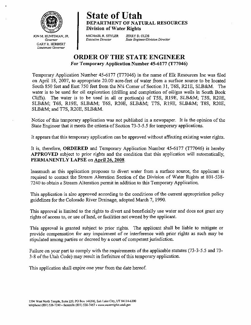
State of UtahDEPARTMENT OF NATURAL RESOURCESDivision of Water Rights
JON M. HUNTSMAN,JR. MICHAEL R. STYLER JERRY D. OLDSGovernor Executive Director State Engineer/Division Director
GARY R. HERBERTLieutenant Governor
ORDER OF THE STATE ENGINEERFor Temporary Application Number 45-6177 (T77046)
Temporary Application Number 45-6177 (T77046) in the name of Elk Resources Inc was filedon April 18, 2007, to appropriate 20.00 acre-feet of water from a surface source to be locatedSouth 850 feet and East 750 feet from the N¼ Corner of Section 31, T6S, R21E, SLB&M. Thewater is to be used for oil exploration (drilling and completion of oil/gas wells in South BookCliffs). The water is to be used in all or portion(s) of TSS, R19E, SLB&M; T5S, R20E,SLB&M; T6S, R19E, SLB&M; T6S, R20E, SLB&M; T7S, R19E, SLB&M; T8S, R20E,SLB&M; and T7S, R20E, SLB&M.
Notice of this temporary application was not published in a newspaper. It is the opinion of theState Engineer that it meets the criteria of Section 73-3-5.5 for temporary applications.
It appears that this temporary application can be approved without affecting existing water rights.
It is, therefore, ORDERED and Temporary Application Number 45-6177 (T77046) is herebyAPPROVED subject to prior rights and the condition that this application will automatically,PERMANENTLY LAPSE on April 26, 2008.
Inasmuch as this application proposes to divert water from a surface source, the applicant isrequired to contact the Stream Alteration Section of the Division of Water Rights at 801-538-7240 to obtain a Stream Alteration permit in addition to this Temporary Application.
This application is also approved according to the conditions of the current appropriation policyguidelines for the Colorado River Drainage, adopted March 7, 1990.
This approval is limited to the rights to divert and beneficially use water and does not grant anyrights of access to, or use of land, or facilities not owned by the applicant.
This approval is granted subject to prior rights. The applicant shall be liable to mitigate orprovide compensation for any impairment of or interference with prior rights as such may bestipulated among parties or decreed by a court of competent jurisdiction.
Failure on your part to comply with the requirements of the applicable statutes (73-3-5.5 and 73-3-8 of the Utah Code) may result in forfeiture of this temporary application.
This application shall expire one year from the date hereof.
1594 West North Temple, Suite 220, PO Box 146300, Salt Lake City, UT 84114-6300telephone (801)538-7240. facsimile (801)
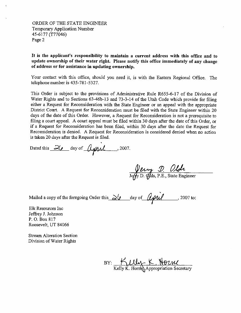
ORDER OF THE STATE ENGINEERTemporary Application Number45-6177 (T77046)Page 2
It is the applicant's responsibility to maintain a current address with this office and toupdate ownership of their water right. Please notify this office immediately of any changeof address or for assistance in updating ownership.
Your contact with this office, should you need it, is with the Eastern Regional Office. Thetelephone number is 435-781-5327.
This Order is subject to the provisions of Administrative Rule R655-6-17 of the Division ofWater Rights and to Sections 63-46b-13 and 73-3-14 of the Utah Code which provide for filingeither a Request for Reconsideration with the State Engineer or an appeal with the appropriateDistrict Court. A Request for Reconsideration must be filed with the State Engineer within 20days of the date of this Order. However, a Request for Reconsideration is not a prerequisite tofiling a court appeal. A court appeal must be filed within 30 days after the date of this Order, orif a Request for Reconsideration has been filed, within 30 days after the date the Request forReconsideration is denied. A Request for Reconsideration is considered denied when no actionis taken 20 days after the Request is filed.
Dated this Ú day of , 2007.
J D. s, P.E., State Engineer
Mailed a copy of the foregoing Order this Mf day of , 2007 to:
Elk Resources IncJeffrey J. JohnsonP. O. Box 817Roosevelt, UT 84066
Stream Alteration SectionDivision of Water Rights
BY:Kelly K. Ho Appropriation
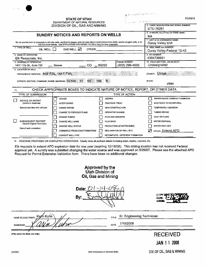
OSTATE OF UTAH FORM 9
DEPARTMENT OF NATURAL RESOURCES --
DIVISIONOF OIL, GAS AND MINING 5. LEASEDESIGNATIONANDSERIALNUMBERUTU-76261
6. IF INDIAN, ALLOTTEEOR TRIBE NAME:SUNDRY NOTICES AND REPORTS ON WELLS NA
7. UNITor CA AGREEMENT NAME:Do not use this form for proposals to driftnew wells, significantly deepen existing wells below current bottom-hole depth, reenter plugged wells, or to
OUra Valle Unitdrillhorizontal laterals. Use APPLICATION FOR PERMIT TO DRILL form for such proposals.
1. TYPE OF WELL 8. WELL NAMEand NUMBER:OIL WELL GAS WELL ./ OTHER Ouray Valley Federal 12-42
2. NAME OF OPERATOR: 9. API NUMBER:
Elk Resources, Inc. 43047389313. ADDRESS OF OPERATOR PHONE NUMBER 10. FIELDAND POOL, OR WILDCAT:
1401 17th St., Suite 700 crw Denver STATE CO z,, 80202 (303) 296-4505 Undesignated4. LOCATION OF WELL
FOOTAGESATSURFACE: 859' FSL, 1847' FWL COUNTY: Uintah
QTR/QTR, SECTION, TOWNSHIP, RANGE, MERIDIAN: SESW 12 6S 19E S STATE:
UTAH
11. CHECK APPROPRIATE BOXES TO INDICATENATURE OF NOTICE, REPORT, OR OTHER DATATYPE OF SUBMISSION TYPE OF ACTION
O ACIDIZE DEEPEN REPERFORATE CURRENT FORMATIONO NOTICE OF INTENT(Submit in Duplicate) ALTERCASING FRACTURE TREAT SIDETRACKTO REPAIR WELL
Approximate date work willstart: CASING REPAIR NEW CONSTRUCTION TEMPORARILYABANDON
O CHANGETO PREVIOUS PLANS OPERATOR CHANGE TUBINGREPAIR
O CHANGETUBING PLUG ANDABANDON VENT OR FLARE
SUBSEQUENT REPORT CHANGEWELL NAME PLUG BACK WATER DISPOSAL(Submit Original Form Only)
O CHANGEWELLSTATUS PRODUCTION (START/RESUME) WATER SHUT-OFFDate ofwork completion:
COMMINGLEPRODUCJNG FORMATIONS RECLAMATION OF WELLSITE OTHER: Extend APD
O CONVERT WELLTYPE RECOMPLETE - DIFFERENT FORMATION
12. DESCRIBE PROPOSED OR COMPLETED OPERATIONS. Clearly show all pertinent details including dates, depths, volumes, etc.
Elk requests to extend APD expiration date for one year (expiring 12/18/08). This drilling location has not received Federalapproval yet. A sundry was submitted changing the water source and was approved on 5/29/07. Please see the attached APDRequest for Permit Extension Validation form. There have been no additional changes.
Approvedby theUtah Divisionof
Oil,Gas and Mining
NAME(PLEASEPRINT) K Kuhn, , TITLE Sr. Engineering Technician
SIGNATURE DATE 1/10/2008
(This space for State use only) RECE IVEDJAN1 1 2008
(5/2000) (See Instructions on Reverse Side) DIV.OFOIL,GAS&
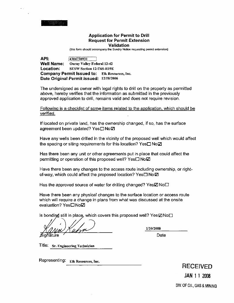
Application for Permit to DrillRequest for Permit Extension
Validation(this form should accompany the Sundry Notice requesting permit extension)
API:Well Name: Ouray Valley Federal12-42Location: SESW Section 12-T6S-R19ECompany Permit Issued to: Elk Resources, Inc.Date Original Permit issued: 12/18/2006
The undersigned as owner with legal rights to drill on the property as permittedabove, hereby verifies that the information as submitted in the previouslyapproved application to drill, remains valid and does not require revision.
Followinq is a checklist of some items related to the application, which should beverified.
If located on private land, has the ownership changed, if so, has the surfaceagreement been updated? YesO NolZI
Have any wells been drilled in the vicinity of the proposed well which would affectthe spacing or siting requirements for this location? YesO NolZI
Has there been any unit or other agreements put in place that could affect thepermitting or operation of this proposed well? YesO NolZI
Have there been any changes to the access route including ownership, or right-of-way, which could affect the proposed location? YesO No IZI
Has the approved source of water for drilling changed? YeslZINoO
Have there been any physical changes to the surface location or access routewhich will require a change in plans from what was discussed at the onsiteevaluation? YesO NolZI
Is bondi still in place which covers this proposed well? YeslZlNoO
1/10/2008
ßignature Date
Title: Sr. Engineering Technician
Representing: Elk Resources, Inc.RECE IVEDJAN1 1 2008
DIV.0FOIL,GAS&
Division of Oil, Gas and Mining ROUTINGOPERATOR CHANGE WORKSHEET 1. DJJ
Change of Operator (Well Sold) X - Operator Name Change/MergerThe operator of the well(s) listed below has changed, effective: 2/11/2008
FROM: (Old Operator): TO: ( New Operator):N2755-Elk Resources, Inc. N3480-Elk Resources, LLC.
1401 17th St, Suite 700 1401 17th St, Suite 700Denver, CO 80202 Denver, CO 80202
Phone: 1 (303) 296-4505 Phone: 1 (303) 296-4505
CA No. Unit: OURAY VALLEYWELL NAME SEC TWN RNG API NO ENTITY LEASE WELL WELL
NO TYPE TYPE STATUSSEE ATTACHED LIST
OPERATOR CHANGES DOCUMENTATIONEnter date after each listed item is completed1. (R649-8-10) Sundry or legal documentation was received from the FORMER operator on: 4/24/20082. (R649-8-10) Sundry or legal documentation was received from the NEW operator on: 4/24/20083. The new company was checked on the Department of Commerce, Division of Corporations Database on: 4/29/20084a. Is the new operator registered in the State of Utah: NO Business Number:4b. If NO, the operator was contacted contacted on: 4/29/20085a. (R649-9-2)Waste Management Plan has been received on: IN PLACE5b. Inspections of LA PA state/fee well sites complete on: N/A5c. Reports current for Production/Disposition & Sundries on: ok
6. Federal and Indian Lease Wells: The BLM and or the BIA bas approved the merger, name change,or operator change for all wells listed on Federal or Indian leases on: BLM 3/13/2008 BIA
7. Federal and Indian Units:The BLM or BIA has approved the successor of unit operator for wells listed on: 3/13/2008
8. Federal and Indian Communization Agreements ("CA"):The BLM or BIA has approved the operator for all wells listed within a CA on: n/a
9. Underground Injection Control ("UIC") The Division has approved UIC Form 5, Transfer of Authority toInject, for the enhanced/secondary recovery unit/project for the water disposal well(s) listed on:
DATA ENTRY:1. Changes entered in the Oil and Gas Database on: 4/29/20082. Changes have been entered on the Monthly Operator Change Spread Sheet on: 4/29/20083. Bond information entered in RBDMS on: 4/29/20084. Fee/State wells attached to bond in RBDMS on: 4/29/20085. Injection Projects to new operator in RBDMS on: n/a6. Receipt of Acceptance of Drilling Procedures for APD/New on: ok
BOND VERIFICATION:1. Federal well(s) covered by Bond Number: UTB0001352. Indian well(s) covered by Bond Number: n/a3a. (R649-3-1) The NEW operator of any fee well(s) listed covered by Bond Number BOOO9693b. The FORMER operator has requested a release of liability from their bond on: n/a
LEASE INTEREST OWNER NOTIFICATION:4. (R649-2-10) The FORMER operator of the fee wells has been contacted and informed by a letter from the Division
of their responsibility to notify all interest owners of this change on: n/aCOMMENTS: Bond was amended from Elk Resources, Inc to Elk Resources, LLC
Elk (Ouray) FORM_B.xls
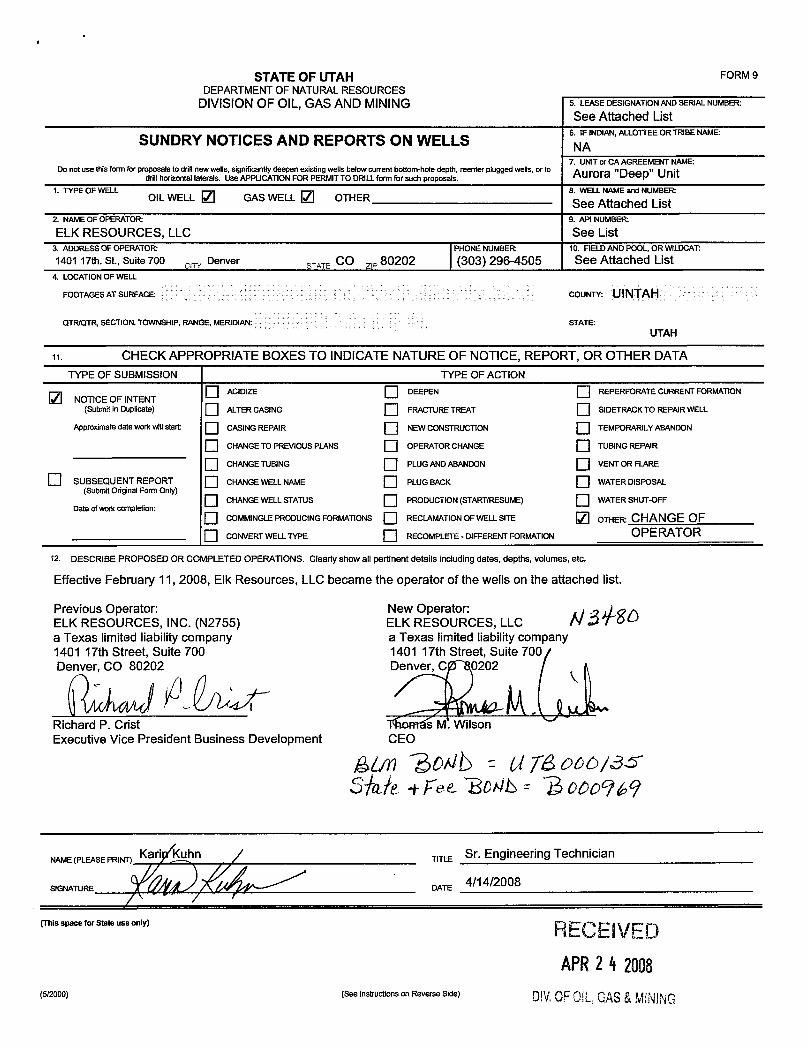
STATE OF UTAH FORM 9DEPARTMENT OF NATURALRESOURCES
DIVISIONOF OIL,GAS AND MINING 5. LEASEDESIGNATIONANDSERIALNUMBER
See Attached List6. IF INDIAN,ALLOTTEEOR TRIBE NAME:
SUNDRY NOTICES AND REPORTS ON WELLS NA7. UNITor CA AGREEMENT NAME:
Do not use this form for proposals to drillnew wells, significantly deepen existing wells below current bottom-hole depth, reenter plugged wells, or to Aurora "Deen" Unitdrillhorizontal laterals. Use APPLICATIONFOR PERMITTO DRILLform forsuch proposals. r
1. TYPE OF WELL 8. WELL NAMEand NUMBEROIL WELL GAS WELL OTHER See Attached List
2. NAMEOF OPERATOR: 9. APl NUMBER
ELK RESOURCES, LLC See List3. ADDRESS OF OPERATOR PHONE NUMBER 10. FIELDAND POOL, OR WILDCAT:
1401 17th. St., Suite 700 ce Denver STATE CO ze 80202 (303) 296-4505 See Attached List4. LOCATIONOF WELL
FOOTAGES AT SURFACE: COUNTY: ÛINTAH
QTR/QTR, SECTION, TOWNSHIP, RANGE, MERIDIAN: STATE:UTAH
CHECK APPROPRIATE BOXES TO INDICATENATURE OF NOTICE, REPORT, OR OTHER DATATYPE OF SUBMISSION TYPE OF ACTION
O ACIDIZE DEEPEN REPERFORATE CURRENT FORMATIONNOTICE OF INTENT
(Submit in Duplicate) ALTERCASING FRACTURE TREAT SIDETRACKTO REPAIR WELL
Approximate date work willstart: CASING REPAIR NEW CONSTRUCTION TEMPORARILYABANDON
O CHANGETO PREVIOUS PLANS OPERATOR CHANGE TUBING REPAIR
O CHANGETUBING PLUG ANDABANDON VENT OR FLARE
O SUBSEQUENT REPORT CHANGEWELLNAME PLUG BACK WATER DISPOSAL(Submit Original Form Only)
O CHANGE WELLSTATUS PRODUCTION (START/RESUME) WATER SHUT-OFFDate ofwork completion:
COMMINGLEPRODUCINGFORMATIONS RECLAMATIONOFWELLSITE OTHER CHANGE OFCONVERTWELLTYPE RECOMPLETE - DIFFERENT FORMATION OPE RATOR
12 DESCRIBE PROPOSED OR COMPLETED OPERATIONS. Clearly show all pertinent details including dates, depths, volumes, etc.
Effective February 11, 2008, Elk Resources, LLC became the operator of the wells on the attached list.
Previous Operator: New Operator:ELK RESOURCES, INC. (N2755) ELK RESOURCES, LLC $Ôa Texas limited liability company a Texas limited liability company1401 17th Street, Suite 700 1401 17th Street, Suite 700De O 80202 Denver, C 0202
Richard P. Crist Thormfs M. WilsonExecutive Vice President Business Development CEO
NAME(PLEASEPRINT) Kari hn TITLE Sr. Engineering Technician
SIGNATURE DATE 4/14/2008
(This space for State use only) RECE IVEDAPR2 4 2003
(5/2000) (See Instructions on Reverse Side) DIV.OFOIL,GAS&
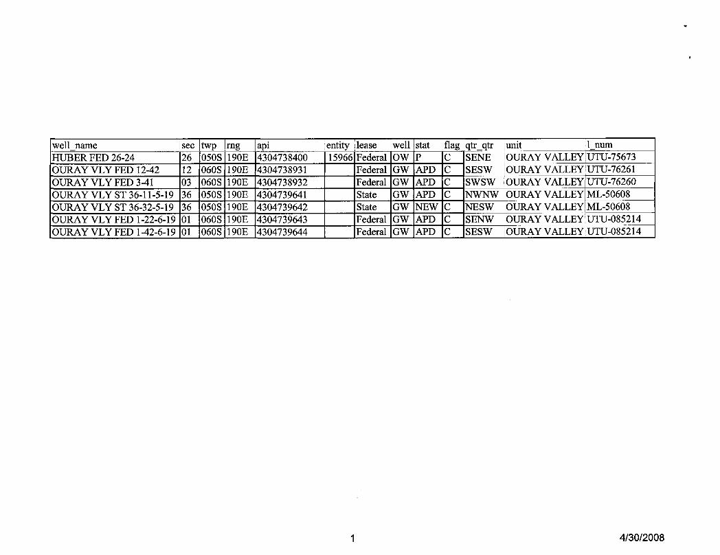
well_name see twp rng api entity lease well stat flag qtr_qtr unit 1 numHUBER FED 26-24 26 050S 190E 4304738400 15966 Federal OW P C SENE OURAY VALLEY UTU-75673OURAY VLY FED 12-42 12 060S 190E 4304738931 Federal GW APD C SESW OURAY VALLEY UTU-76261
OURAY VLY FED 3-41 03 060S 190E 4304738932 Federal GW APD C SWSW OURAY VALLEY UTU-76260OURAY VLY ST 36-11-5-19 36 050S 190E 4304739641 State GW APD C NWNW OURAY VALLEY ML-50608OURAY VLY ST 36-32-5-19 36 050S 190E 4304739642 State GW NEW C NESW OURAY VALLEY ML-50608OURAY VLY FED 1-22-6-19 01 060S 190E 4304739643 Federal GW APD C SENW OURAY VALLEY UTU-085214OURAY VLY FED 1-42-6-19 01 060S 190E 4304739644 Federal GW APD C SESW OURAY VALLEY UTU-085214
1
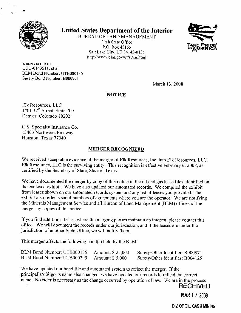
United States Department of the InteriorBUREAU OF LAND MANAGEMENT
Utah State OfficeTAKE PRIDE°
P.O. Box 45155 *Ng ERICASalt Lake City, UT 84145-0155
http://www.blm.cov/ut/st/en.html
IN REPLYREFER TO:UTU-0143511, et al.BLM Bond Number: UTB000135Surety Bond Number: B000971
March 13, 2008
NOTICE
Elk Resources, LLC1401 17thStreet, Suite 700Denver, Colorado 80202
U.S. Specialty Insurance Co.13403 Northwest FreewayHouston, Texas 77040
MERGER RECOGNIZED
We received acceptable evidence of the merger of Elk Resources, Inc. into Elk Resources, LLC.Elk Resources, LLC is the surviving entity. This recognition is effective February 6, 2008, ascertified by the Secretary of State, State of Texas.
We have documented the merger by copy of this notice in the oil and gas lease files identified onthe enclosed exhibit. We have also updated our automated records. We compiled the exhibitfrom leases shown on our automated records system and any list of leases you provided. Theexhibit also reflects serial numbers of agreements where you are the operator. We are notifyingthe Minerals Management Service and all Bureau of Land Management (BLM) offices of themerger by copies of this notice.
If you find additional leases where the merging parties maintain an interest, please contact thisoffice. We will document the records under our jurisdiction,and if the leases are under thejurisdictionof another State Office, we will notify them.
This merger affects the following bond(s) held by the BLM:
BLM Bond Number: UTB000135 Amount: $ 25,000 Surety/Other Identifier: B000971BLM Bond Number: UTB000299 Amount: $ 5,000 Surety/Other Identifier: B004125
We have updated our bond file and automated system to reflect the merger. If theprincipal's/obligor's name also changed, we have updated our records to reflect the correctname. No rider is necessary as the change occurred by operation of law. We are in the process
RECEIVEDMAR17 2008
DIV.0FOIL,GAS&
of determining the total liability for the leases affected by the merger and may require increasedcoverage in a later action.
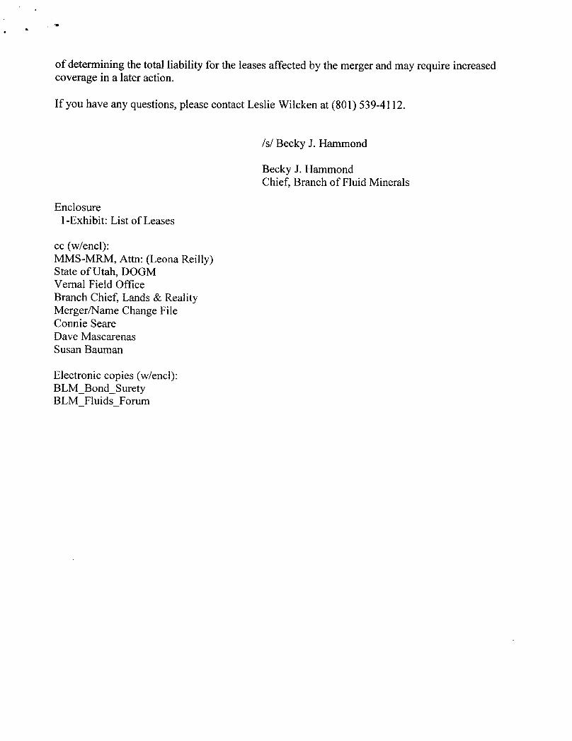
If you have any questions, please contact Leslie Wilcken at (801) 539-4112.
/s/ Becky J. Hammond
Becky J. HammondChief, Branch of Fluid Minerals
Enclosure1-Exhibit: List of Leases
cc (w/encl):MMS-MRM, Attn: (Leona Reilly)State of Utah, DOGMVernal Field OfficeBranch Chief, Lands & RealityMerger/Name Change FileConnie SeareDave MascarenasSusan Bauman
Electronic copies (w/encl):BLM Bond_SuretyBLM Fluids
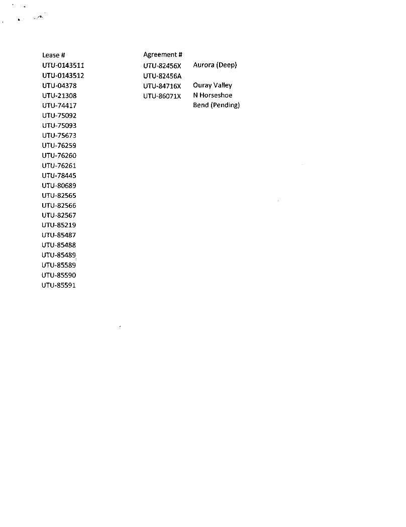
Lease # Agreement #UTU-0143511 UTU-82456X Aurora (Deep)UTU-0143512 UTU-82456AUTU-04378 UTU-84716X Ouray ValleyUTU-21308 UTU-86071X N HorseshoeUTU-74417 Bend (Pending)UTU-75092UTU-75093UTU-75673UTU-76259UTU-76260UTU-76261UTU-78445UTU-80689UTU-82565UTU-82566UTU-82567UTU-85219UTU-85487UTU-85488UTU-85489UTU-85589UTU-85590
Foun3160-3 FORMAPPROVED(February2005) OMBNo.10044137
ExpiresMarch31, 2007UNITED STATES
DEPARTMENTOF THE INTERIOR 5. LeaseSerialNo.UTU-76261
BUREAU OF LAND MANAGEMENT
APPLICATION FOR PERMIT TO DRILL OR REENTER6. If Indian,Alloteeor TribeName
NA
la. Typeofwork: DRILL REENTER7 IfUnitor CAAgreement,Nameand No.
8. LeaseNamean ell No.Ib. TypeofWell: Oil Wen GasWell Other S ne Zone Ouray Valley Federal 12-42
1 Nameof Operator 9. API WellNo.Elk Resources, Inc.
3a. Address 1401 17th Street, Suite 700 3b. che är d 10 FreldandPool,orExploratoryDenver, CO 80202 303-296-4505 Exploratory
4. Locationof Well (Report location clearly and in acord mce with any Staterequiremens.*) 11.Sec.,T.R.M. or Blk.andSurveyorArea
Atsurface 859' FSL, 1847' FWL
At proposedprod.zone 859' FSL, 184T FWLLot 9, Sec. 12-T6S-R19E, SLB&M
14. Distanceinmiles anddirectionfromnearest townorpostoffice* 12.CountyorParish 13. StateApproximately 17.3 miles Southwest of Vernal, UT Uintah County UT
15. Distancefromproposed* 16. No. of acres inlease 17 SpacingUnitdedicated10 thiswelllocationtonearestpropertyorleaseline,ft(Also tonearest drig.unitline,if any) 859' 1400.84 40
18. Distancefromproposedlocation* 19.ProposedDepth 20. BLM/BIABond No.onfileto nearestwell, drilling,completed,applied for,on thislease,ft. NA 14500' BLM: UTB000135
21. Elevations(Showwhether DF,KDB,RT,GL,etc.) 22 Approximatedatework will start* 21 Estimatedduration5212' GR 03/01/2007 60 days drilling, 30 days completion
24. AttachmentsThefollowing,completedin accordance with therequirements of OnshoreOilandGasOrderNo.1,must beattachedtothisfornr
1. Well platcertified bya registered surveyor. 4. Bondto coverthe operations unless covered byan existing bondon file(see2 A DrillingPlan. Item20above).3. A SurfaceUse Plan(if the locationis on NationalForestSystemLands,the 5. Operatorcertification
SUPO must be filedwith appropriate Forest rvice Office). 6. Suchother site specificinformationand/or plansas may be required bytheBLM.
25. Signature Name(PrintedTyped) Date
TitleKarin Kuhn 12/05/2006
Sr ngineering Technician
Approved
.ã IdMariagei'oN Mnted/T De
// nd MineralResowees VERNALFIELDOFFICEApplicationapprovaldoesnotwarrant orcertify thattheapplicantholdslegalorequitabletitletothoserightsinthesubjectleasewhichwould entitle theapplicanttoconductoperationsthereon.Conditionsofapproval,if any,areattached.
Title18U.S.C.Section1001andTitle43 U.S.C.Section1212,make it a crime forany personknowingly.andwillfully tomake toanydepartmentor agencyofthe UnitedStatesany false,fictitiousor fraudulentstatementsorrepresentationsastoanymatterwithin itsjurisdiction.
*(Instructions on page 2)
CONDITIONSOF APPROVALATTACHEDNOTICEOFAPP VAi, RECEIVED
JUN24 2008DIV.0FOlL, I
d7 Sk
UNITED STATES DEPARTMENT OF THE INTERIORBUREAUOF LAND MANAGEMENT
• • VERNAL FIELD OFFICEht. ' 170 South 500 East VERNAL, UT 84078 (435) 781-4400
CONDITIONS OF APPROVAL FOR APPLICATION FOR PERMTT TO DRILL
Company: Elk Resources, LLC Location: Lot 9, Sec. 12, T6S, R19EWell No: Ouray Valley Federal 12-42 Lease No: UTU-76261API No: 43-047-38931 Agreement: Ouray Valley Unit
Title Name Office Phone Number Cell Phone NumberPetroleum Engineer: Matt Baker (435) 781-4490 (435) 828-4470Petroleum Engineer: Michael Lee (435) 781-4432 (435) 828-7875Petroleum Engineer: James Ashley (435) 781-4470 (435) 828-7874Petroleum Engineer: Ryan Angus (435) 781-4430 (435) 828-7368Supervisory Petroleum Technician: Jamie Sparger (435) 781-4502 (435) 828-3913Supervisory NRS: Karl Wright (435) 781-4484 (435) 828-7381NRS/Enviro Scientist: Holly Villa (435) 781-4404 (435) 828-3544NRS/Enviro Scientist: James Hereford (435) 781-3412NRS/Enviro Scientist: Chuck Macdonald (435) 781-4441 (435) 828-7481NRS/Enviro Scientist: Dan Emmett (435) 781-3414NRS/Enviro Scientist: Paul Percival (435) 781-4493NRS/Enviro Scientist: Michael Cutler (435) 781-3401 (435) 828-3546NRS/Enviro Scientist: Anna Figueroa (435) 781-3407 (435) 828-3548NRS/Enviro Scientist: Verlyn Pindell (435) 781-3402 (435) 828-3547NRS/Enviro Scientist: Darren Williams (435) 781-4447 (435) 828-4029NRS/Enviro Scientist: Nathan Packer (435) 781-3405 (435) 828-3545
Fax: (435) 781-3420
A COPY OF THESE CONDITIONS SHALL BE FURNISHED TO YOURFIELD REPRESENTATIVE TO INSURE COMPLIANCE
All lease and/or unit operations are to be conducted in such a manner that full compliance is made with theapplicable laws, regulations (43 CFR Part 3160), and this approved Application for Permit to Drill includingSurface and Downhole Conditions of Approval. The operator is considered fully responsible for the actions of hissubcontractors. A copy of the approved APD must be on location during construction, drilling, and completionoperations. This permit is approved for a two (2) year period, or until lease expiration, whichever occursfirst. An additional extension, up to two (2) years, may be applied for by sundry notice prior to expiration.
NOTIFICATION REQUIREMENTS
Location Construction - Forty-Eight (48) hours prior to construction of location and(Notify_Environmental Scientist) access roads.Location Completion - Prior to moving on the drilling rig.
ogEnvironmental Scientist)Spud Notice - Twenty-Four (24) hours prior to spudding the well.Notify Petroleum Engineer)Casing String & Cementing - Twenty-Four (24) hours prior to running casing and cementing(Notify Supv. Petroleum Tech.) all casing strings.BOP & Related Equipment Tests - Twenty-Four (24) hours prior to initiating pressure tests.(Notgupv. Petroleum Tech.)First Production Notice - Within Five (5) business days after new well begins or(Notify Petroleum Engineer) production resumes after well has been off production for more
than ninety (90)
Page 2 of 10Well: Ouray Valley Federal 12-42
6/16/2008
SURFACE USE PROGRAMCONDITIONS OF APPROVAL (COAs)
Surface COAs:
• If there is an active Gilsonite mining operation within 2 miles of the well location, operator shallnotify the Gilsonite operator at least 48 hours prior to any blasting during construction.
• If paleontological materials are uncovered during construction, the operator is to immediatelystop work and contact the Authorized Officer (AO). A determination will be made by the AO asto what mitigation may be necessary for the discovered paleontologic material beforeconstruction can continue.
Additional Surface Conditions of Approval or monitoring listed in the Surface Use Plan of the APD's.
Site Specgic COAs:
Wildlife Stipulations/COAs:
Golden Eagle
Mitigation Measures:• There are two known nest sites within 0.5 miles of the proposed location (Ouray Valley
Federal #3-41). With these occurrences, there will be a timing restriction to protect GoldenEagle nesting from February 1 - July 15. Prior to any construction between 1 Februaryand 15 July, all areas within 0.5 mile of proposed development locations will be surveyedfor Golden Eagle nests. If active nests were identified, no surface disturbance will occurwithin 0.5 mile of the nest from February 1 to July 15, and no permanent structures will beconstructed within 0.5 mile of the nest, unless the nest is topographically screened orlocated within an artificial nesting structure.
• Lease Notices from RMP: The lessee/operator is given notice the area has been identified ascontaining Golden Eagle and Ferruginous Hawk habitat. Modifications may be required in theSurface Use Plan to protect the Golden Eagles and Ferruginous Hawk and/or their habitat fromsurface disturbance activities in accordance with Section 6 of the lease terms, EndangeredSpecies Act, and 43 CFR 3101.1-2.
• Threatened and Endangered Fish Mitigation for Water Supply1. The best method to avoid entrainment is to pump from an off-channel location - one that
does not connect to the river during high spring flows. An infiltration gallery constructedin a BLM and Service approved location is best.
2. If the pump head is located in the river channel where larval fish are known to occur, thefollowing measures apply:
a. do not situate the pump in a low-flow or no-flow area as these habitats tend toconcentrate larval
Page 3 of 10Well: Ouray Valley Federal 12-42
6/16/2008
b. limit the amount of pumping, to the greatest extent possible, during that period ofthe year when larval fish may be present (see above); and
c. limit the amount of pumping, to the greatest extent possible, during the pre-dawnhours as larval drift studies indicate that this is a period of greatest daily activity.
3. Screen all pump intakes with ¼" mesh material.4. Report any fish impinged on the intake screen to the Service (801.975.3330) and the Utah
Division of Wildlife Resources:
Northeastern Region152 East 100 North, Vernal, UT 84078Phone: (435) 781-9453
CONDITIONS OF APPROVAL:
• Submit Sundry Notice Form 3160-5 for pipeline requests and necessary right-of-ways toAuthorized Officer of the Vernal BLM if well are productive. A Sundry Notice will detail anychanges in pipeline proposal from the Proposed Action.
• Prior to water disposal, submit Sundry Notice Form 3160-5 specifying Approved Water Disposalfacilities to be used in conjunction with Proposed Action.
• During operations, if any vertebrate paleontological resources are discovered, all operationsaffecting such sites shall be immediately suspended, and all discoveries shall be left intact untilauthorized to proceed by the Authorized Officer. The Authorized Officer of the Vernal BLMoffice shall be notified within 48 hrs of the discovery and a decision as to the preferredalternative/course of action will be rendered.
• The operator will control noxious weeds along access road use authorizations, pipeline routeauthorizations, well sites, or other applicable facilities by spraying or mechanical removal. A listof noxious weeds may be obtained from the BLM weeds specialist or the appropriate CountyExtension Office. On BLM administered land, it is required that a Pesticide Use Proposal (PUP)be submitted and approved prior to the application of herbicides, pesticides or possiblyhazardous chemicals.
• All applicable local, state, and/or federal laws, regulations, and/or statutes will be complied with.
• All traffic related to this action will be restricted to approved routes. Cross-country vehicletravel will not be allowed.
• No vehicle travel, construction or routine maintenance activities shall be performed duringperiods when the soil is too wet to adequately support vehicles and/or construction equipment. Ifsuch equipment creates ruts in excess of four inches deep, the soil shall be deemed too wet toadequately support construction equipment.
• The access road will be crowned and ditched. Flat-bladed roads are not
Page 4 of 10Well: Ouray Valley Federal 12-42
6/16/2008
• If additional erosion occurs during the life of this project, more culverts, low water crossings,berms, wing ditches or etc. will be needed to control the erosion.
• Low-water crossings will be appropriately constructed to avoid sedimentation of drainage waysand other water resources.
• Pipelines will be buried at all major drainage crossings.
• Prevent fill and stock piles from entering drainages.
• The reserve pit will be lined with 12 ml or greater liner and 1 felt liner prior to spudding.
• The liner is to be cut 5 feet below ground surface or at the level of the cuttings, whichever isdeeper, and the excess liner material is to be disposed of at an authorized disposal site.
• When the reserve pit contains fluids or toxic substances, the operator must ensure animals do notingest or become entrapped in pit fluids.
• If Uinta Basin hookless cactus or other special status plants are found, construction will ceaseand the AO will be notified to determine the appropriate mitigation.
• The authorized officer may prohibit surface disturbing activities during severe winter conditionsto minimize watershed damage. This limitation does not apply to operation and maintenance ofproducing wells.
• The authorized officer may prohibit surface disturbing activities during wet or muddy conditionsto minimize watershed damage. This limitation does not apply to operation and maintenance ofproducing wells.
• All permanent (on-site six months or longer), above ground structures constructed or installed,including pumping units, any subsequent approved equipment/facilities will be painted a flat,non-reflective, earth tone color to match one of the standard environmental colors, as determinedby the five state Rocky Mountain Inter-Agency Committee. All facilities will be painted withinsix months of installation. Facilities required to comply with the Occupational Safety and HealthAct (OSHA) will be excluded. The requested color is Carlsbad Canyon as determinedduring the on-site inspection.
Reclamation:
• Before any interim reclamation dirt work takes place, the reserve pit will be as dry as possible.All debris will be removed. Other waste and spoil materials will be disposed of immediatelyupon completion of operations. As a Best Management Practice, the reserve pit and the locationup to the deadman will be re-contoured to the approximate natural contours. The reserve pit willbe reclaimed within 90 days from the date of well completion, weather permitting. To preventsurface water from standing (ponding) on the reclaimed reserve pit area, final reclamation of thereserve pit will consist of "mounding" the surface three feet above surrounding ground surface
Page 5 of 10Well: Ouray Valley Federal 12-42
6/16/2008
allow the reclaimed pit area to drain effectively. Upon completion of backfilling leveling, andre-contouring, the stockpiled topsoil will be spread evenly over the reclaimed area and then willbe seeded using the following seed mix.
Interim seed mix:Bottlebrush Squirreltail grass Elymus elymoides 1 lbs/acreHy-crest Crested Wheatgrass Agropyron cristatum 9 lbs/acreWyoming Big SagebrushArtemisia tridentata var. Wyomingensis 1 lbs/acreShadscale saltbush Atriplex confertifolia 1 lbs/acre
Final reclamation seed mix:Bottlebrush Squirreltail grass Elymus elymoides 1 lbs/acreHy-crest Crested Wheatgrass Agropyron cristatum 9 lbs/acreWyoming Big SagebrushArtemisia tridentata var. Wyomingensis l lbs/acreShadscale saltbush Atriplex confertifolia l lbs/acre
• All pounds are in pure live seed.• All seed and mulch will be certified weed free.• Drill seeding is the preferred method.• Rates are set for drill seeding; double the rate if broadcasting.• If broadcasting seed: The seed will be walked into the soil with a dozer
immediately after the seeding is completed, or covered by soil using a drag chain.• The seedbed shall be prepared prior to seeding by ripping approximately 6" deep
using a dozer or roughening the ground surface. Ideally the ripping shall be crosshatched. The first rip shall be in the direction of the flow of run off water. Thesecond rip shall be cross ways to the first rip. On slopes that are prone to erosion,terracing with the contour of the slope shall be done to reduce erosion.
· Reseeding may be required if initial seeding is not successful.
• Trees and woody debris must be removed from the site and piled separately off site and saved forfinal reclamation. During final reclamation the trees and woody debris will be loped andscattered over the re-contoured and seeded areas, and spread evenly across the site. Trees andwoody debris will not account for more than 20% of the total surface area of the site.
• Once the location is plugged and abandoned, it shall be re-contoured to the natural topography,topsoil shall be re-spread, and the entire location shall be seeded with the final reclamation seedmix. Seed application will follow all guidelines in the interim seed mix bullet statement above.If reclamation seeding should take place using the broadcast method, the seed at a minimum willbe walked into the soil with a dozer, immediately after the seeding is completed, or covered bysoil using a drag chain.
• All boulders with a length or diameter greater than 3 feet, that are found showing at the surface,will be stockpiled for use during final reclamation.
• Notify the Authorized Officer 48 hours prior to surface disturbing
Page 6 of 10Well: Ouray Valley Federal 12-42
6/16/2008
DOWNHOLE CONDITIONS OF APPROVAL (COAs):
SITE SPECIFIC COAs:
• All requirements regarding 5M & 10M BOPE in Onshore Order #2 Drilling Operations shall bestrictly adhered to.
• The 5M BOPE shall be installed and tested on the 9-5/8" casing and the 10M BOPE shall beinstalled and tested on the 7" casing.
• All casing strings shall be tested in accordance with requirements in Onshore Order #2 DrillingOperations.
• Casing shoe integrity tests are required on all casing shoes.
• Production casing cement top shall be at a minimum of 200' above the surface casing shoe.
• A Cement Bond Log (CBL) shall be run from TD to the base of the surface casing.
All provisions outlined in Onshore Oil & Gas Order #2 Drilling Operations shall be strictlyadhered to. The following items are emphasized:
DRILLINGICOMPLETIONIPRODUCING OPERATING STANDARDS
• The spud date and time shall be reported orally to Vernal Field Office within 24 hours ofspudding.
• Notify Vernal Field Office Supervisory Petroleum Engineering Technician at least 24 hours inadvance of casing cementing operations and BOPE & casing pressure tests.
• Blowout prevention equipment (BOPE) shall remain in use until the well is completed orabandoned. Closing unit controls shall remain unobstructed and readily accessible at all times.Choke manifolds shall be located outside of the rig substructure.
• All BOPE components shall be inspected daily and those inspections shall be recorded in thedaily drilling report. Components shall be operated and tested as required by Onshore Oil & GasOrder No. 2 to insure good mechanical working order. All BOPE pressure tests shall beperformed by a test pump with a chart recorder and NOT by the rig pumps. Test shall bereported in the driller's log.
• BOP drills shall be initially conducted by each drilling crew within 24 hours of drilling out fromunder the surface casing and weekly thereafter as specified in Onshore Oil & Gas Order No.
Page 7 of 10Well: Ouray Valley Federal 12-42
6/16/2008
• Casing pressure tests are required before drilling out from under all casing strings set andcemented in place.
• No aggressive/fresh hard-banded drill pipe shall be used within casing.
• Cement baskets shall not be run on surface casing.
• The operator must report all shows of water or water-bearing sands to the BLM. If flowingwater is encountered it must be sampled, analyzed, and a copy of the analyses submitted to theBLM Vernal Field Office.
• The operator must report encounters of all non oil & gas mineral resources (such as Gilsonite, tarsands, oil shale, trona, etc.) to the Vernal Field Office, in writing, within 5 working days of eachencounter. Each report shall include the well name/number, well location, date and depth (fromKB or GL) of encounter, vertical footage of the encounter and, the name of the person makingthe report (along with a telephone number) should the BLM need to obtain additionalinformation.
• A complete set of angular deviation and directional surveys of a directional well will besubmitted to the Vernal BLM office engineer within 30 days of the completion of the well.
• Chronologic drilling progress reports shall be filed directly with the BLM, Vernal Field Officeon a weekly basis in sundry, letter format or e-mail to the Petroleum Engineers until the well iscompleted.
• A cement bond log (CBL) will be run from the production casing shoe to the top of cement andshall be utilized to determine the bond quality for the production casing. Submit a field copy ofthe CBL to this office.
• Please submit an electronic copy of all other logs run on this well in LAS format [email protected]. This submission will supersede the requirement forsubmittal of paper logs to the BLM.
• There shall be no deviation from the proposed drilling, completion, and/or workover program asapproved. Safe drilling and operating practices must be observed. Any changes in operationmust have prior approval from the BLM Vernal Field
Page 8 of 10Well: Ouray Valley Federal 12-42
6/16/2008
OPERATING REQUIREMENT REMINDERS:
• All wells, whether drilling, producing, suspended, or abandoned, shall be identified inaccordance with 43 CFR 3162.6. There shall be a sign or marker with the name of the operator,lease serial number, well number, and surveyed description of the well.
• In accordance with 43 CFR 3162.4-3, this well shall be reported on the "Monthly Report ofOperations" (Oil and Gas Operations Report ((OGOR)) starting with the month in whichoperations commence and continue each month until the well is physically plugged andabandoned. This report shall be filed in duplicate, directly with the Minerals ManagementService, P.O. Box 17110, Denver, Colorado 80217-0110, or call 1-800-525-7922 (303) 231-3650 for reporting information.
• Should the well be successfully completed for production, the BLM Vernal Field office must benotified when it is placed in a producing status. Such notification will be by writtencommunication and must be received in this office by not later than the fifth business dayfollowing the date on which the well is placed on production. The notification shall provide, as aminimum, the following informational items:
o Operator name, address, and telephone number.
o Well name and number.
o Well location (¼¼,Sec., Twn, Rng, and P.M.).
o Date well was placed in a producing status (date of first production for which royalty willbe paid).
o The nature of the well's production, (i.e., crude oil, or crude oil and casing head gas, ornatural gas and entrained liquid hydrocarbons).
o The Federal or Indian lease prefix and number on which the well is located; otherwise thenon-Federal or non-Indian land category, i.e., State or private.
o Unit agreement and/or participating area name and number, if applicable.
o Communitization agreement number, if applicable.
• Any venting or flaring of gas shall be done in accordance with Notice to Lessees (NTL) 4A andneeds prior approval from the BLM Vernal Field Office.
• All undesirable events (fires, accidents, blowouts, spills, discharges) as specified in NTL 3A willbe reported to the BLM, Vernal Field Office. Major events, as defined in NTL3A, shall bereported verbally within 24 hours, followed by a written report within 15 days. "Other thanMajor Events" will be reported in writing within 15 days. "Minor Events" will be reported onthe Monthly Report of Operations and
Page 9 of 10Well: Ouray Valley Federal 12-42
6/16/2008
• Whether the well is completed as a dry hole or as a producer, "Well Completion andRecompletion Report and Log" (BLM Form 3160-4) shall be submitted not later than 30 daysafter completion of the well or after completion of operations being performed, in accordancewith 43 CFR 3162.4-1. Two copies of all logs run, core descriptions, and all other surveys ordata obtained and compiled during the drilling, workover, and/or completion operations, shall befiled on BLM Form 3160-4. Submit with the well completion report a geologic report including,at a minimum, formation tops, and a summary and conclusions. Also include deviation surveys,sample descriptions, strip logs, core data, drill stem test data, and results of production tests ifperformed. Samples (cuttings, fluid, and/or gas) shall be submitted only when requested by theBLM, Vernal Field Office.
• All off-lease storage, off-lease measurement, or commingling on-lease or off-lease, shall haveprior written approval from the BLM Vernal Field Office.
• Oil and gas meters shall be calibrated in place prior to any deliveries. The BLM Vernal FieldOffice Petroleum Engineers will be provided with a date and time for the initial meter calibrationand all future meter proving schedules. A copy of the meter calibration reports shall besubmitted to the BLM Vernal Field Office. All measurement facilities will conform to the APIstandards for liquid hydrocarbons and the AGA standards for natural gas measurement. Allmeasurement points shall be identified as the point of sale or allocation for royalty purposes.
• A schematic facilities diagram as required by Onshore Oil & Gas Order No. 3 shall be submittedto the BLM Vernal Field Office within 30 days of installation or first production, whicheveroccurs first. All site security regulations as specified in Onshore Oil & Gas Order No. 3 shall beadhered to. All product lines entering and leaving hydrocarbon storage tanks will be effectivelysealed in accordance with Onshore Oil & Gas Order No. 3.
• Any additional construction, reconstruction, or alterations of facilities, including roads, gatheringlines, batteries, etc., which will result in the disturbance of new ground, shall require the filing ofa suitable plan and need prior approval of the BLM Vernal Field Office. Emergency approvalmay be obtained orally, but such approval does not waive the written report requirement.
• No location shall be constructed or moved, no well shall be plugged, and no drilling or workoverequipment shall be removed from a well to be placed in a suspended status without priorapproval of the BLM Vernal Field Office. If operations are to be suspended for more than 30days, prior approval of the BLM Vernal Field Office shall be obtained and notification givenbefore resumption of operations.
• Pursuant to Onshore Oil & Gas Order No. 7, this is authorization for pit disposal of waterproduced from this well for a period of 90 days from the date of initial production. A permanentdisposal method must be approved by this office and in operation prior to the end of this 90-dayperiod. In order to meet this deadline, an application for the proposed permanent disposalmethod shall be submitted along with any necessary water analyses, as soon as possible, but nolater than 45 days after the date of first production. Any method of disposal which has not beenapproved prior to the end of the authorized 90-day period will be considered as an Incident ofNoncompliance and will be grounds for issuing a shut-in order until an acceptable manner fordisposing of said water is provided and approved by this
Page 10 of 10Well: Ouray Valley Federal 12-42
6/16/2008
• Unless the plugging is to take place immediately upon receipt of oral approval, the Field OfficePetroleum Engineers must be notified at least 24 hours in advance of the plugging of the well, inorder that a representative may witness plugging operations. If a well is suspended orabandoned, all pits must be fenced immediately until they are backfilled. The "SubsequentReport of Abandonment" (Form BLM 3160-5) must be submitted within 30 days after the actualplugging of the well bore, showing location of plugs, amount of cement in each, and amount ofcasing left in hole, and the current status of the surface
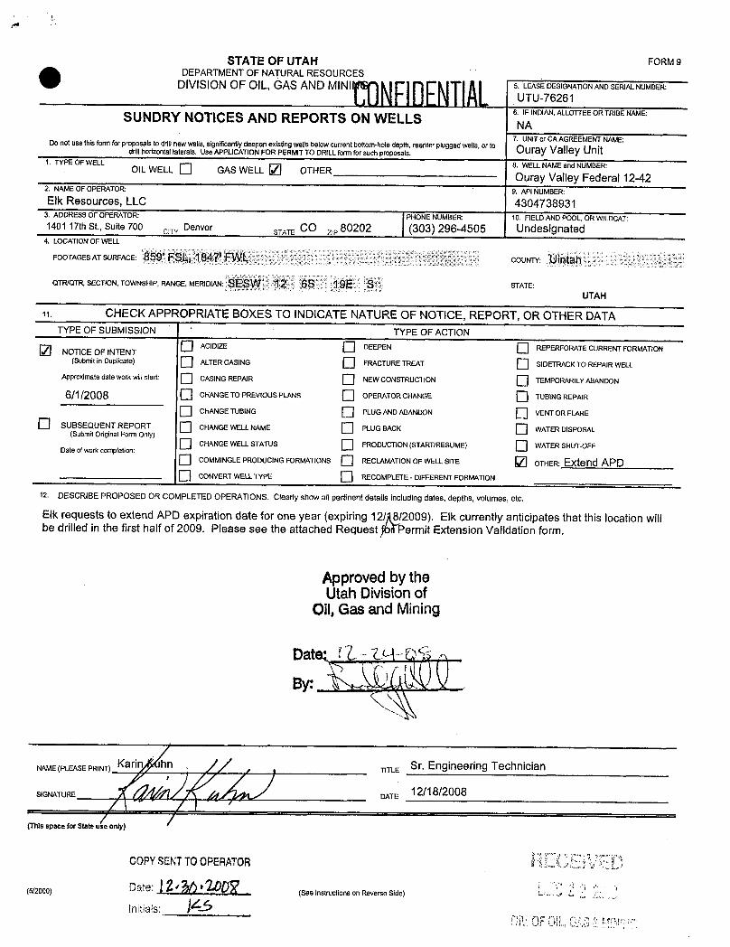
STATE OF UTAH FORM9
O DEPARTMENTOF NATURALRESOURCESDIVISIONOF OIL, GAS AND MINI 5. LEASE DESIGNATIONAND SERIALNUMBER'
UTU-762616. IF INDIAN,ALLOTTEEOR TRIBENAMESUNDRYNOTICES AND REPORTS ON WELLS NA7. UNITor CA AGREEMEI<TNAME:Do not use thisform for proposals todrillnewwells, significantlydeepen existing wells below currentbottom-hole depth, reenter plugged wells,ort° Oura Valle Unitdrill horizontal laterals. Use APPLICATIONFOR PERMITTO DRILLform for such proposals.
1. TYPE OF WELL 8. WELLNAMEand NUMBER:OIL WELL Ü GAS WELL O OTHER Ouray Valley Federal 12-422. NAMEOF OPERATOR 9. API NUMBER:Elk Resources, LLC 4304738931
3. ADDRESS OF OPERATOR PHONE NUMBER 10. FIELDAND POOL, OR WILDCAT:1401 17th St., Suite 700 ce Denver STATE CO z,, 80202 (303) 296-4505 Undesignated
4. LOCATIONOF WELL
FOOTAGESATSURFACE: 859' FSL, 1847' FWL COUNTY: Uintah
QTR/QTR, SECTION, TOWNSHIP, RANGE, MERIDIAN SESW 12 6S 19E S STATE:UTAH
CHECK APPROPRIATEBOXES TO INDICATENATUREOF NOTICE, REPORT, OR OTHER DATATYPE OF SUBMISSION TYPE OF ACTION
O ACIDIZE DEEPEN REPERFORATE CURRENTFORMATIONNOTICE OF INTENT(Submit in Duplicate) ALTERCASING FRACTURETREAT SIDETRACKTO REPAIRWELL
Approximate date work willstart: CASINGREPAIR NEWCONSTRUCTION TEMPORARILYABANDON
6/1/2008 CHANGETO PREVIOUS PLANS OPERATOR CHANGE TUBlNG REPAIR
CHANGETUBING PLUGANDABANDON VENT OR FLARE
SUBSEQUENT REPORT CHANGEWELLNAME PLUG BACK WATERDISPOSAL(Submit Original Form Only)CHANGEWELLSTATUS PRODUCTION(START/RESUME) WATERSHUT-OFF
Date ofwork completion:
O COMMINGLEPRODUCING FORMATIONS RECLAMATIONOF WELLSITE OTHER: Extend APDO CONVERT WELLTYPE RECOMPLETE - DIFFERENT FORMATION
12. DESCRIBE PROPOSED OR COMPLETED OPERATIONS. Clearly show all pertinent details including dates, depths, volumes, etc.
Elk requests to extend APD expiration date for one year (expiring 12 8/2009). Elk currently anticipates that this location willbe drilled in the first half of 2009. Please see the attached Request ermit Extension Validation form.
Approvedby theUtahDivisionof
Oil,Gas and Mining
NAME(PLEASEPRINT) KariTITLE Sr. Engineering Technician
SIGNATURE DATE 12/18/2008
(This space for State use only)
COPYSENTTOOPERATOR
(5/2000) --- (See instructions on Reverse
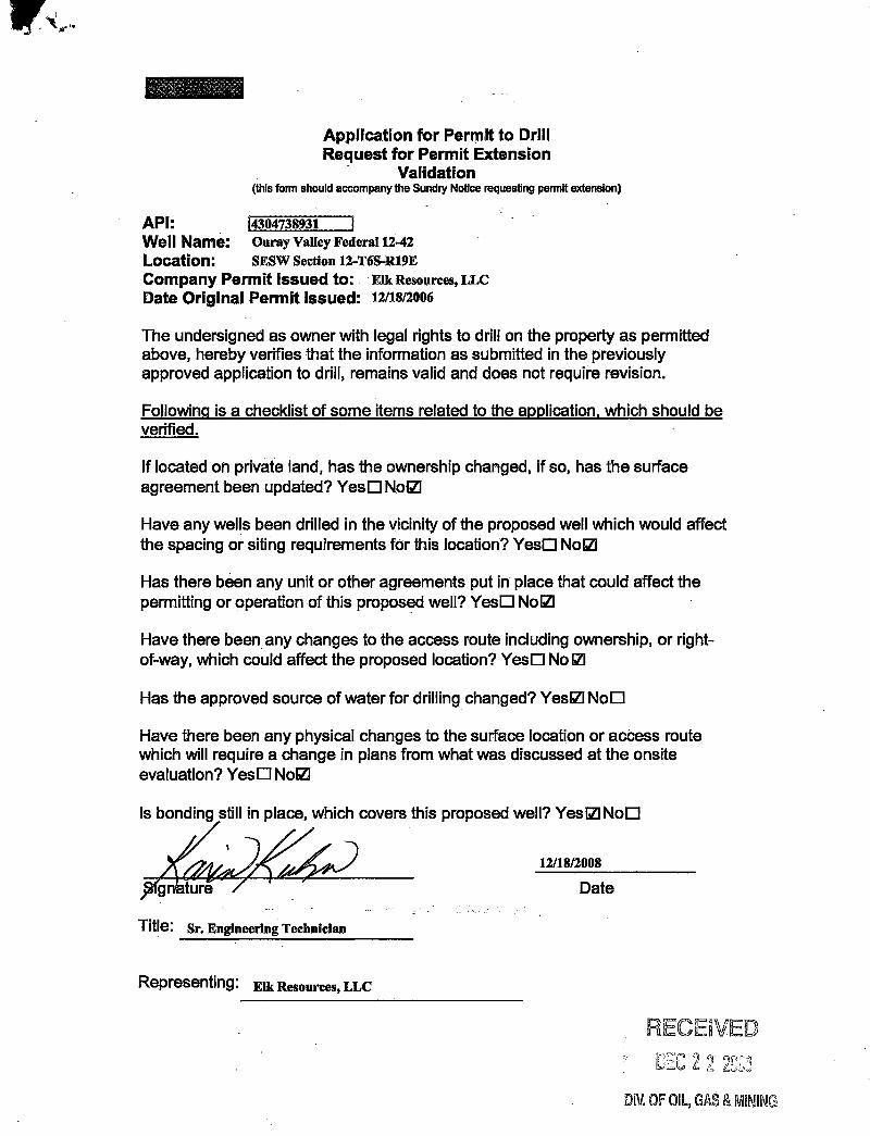
Application for Permit to DrillRequest for Permit Extension
Validation(thisform should accompany the Sundry Notice requesting permit extension)
API: \4304138931 |Well Name: Ouray Valley Federal12-42
Location: SESW Section 12-T6S-R19ECompany Permit issued to: ElkResources,LLCDate Original Permit Issued: 12/18/2006
The undersigned as owner with legal rights to drillon the property as permittedabove, hereby verifies thatthe informationas submitted in the previouslyapprovedapplication to drill,remains valid and does not require revision.
Followingis a checklist of some items related to the application, which should beverified.
If located on private land, has the ownership changed, ifso, has the surfaceagreement been updated7 YesO Nom
Have any wells been drilled in thevicinityof the proposed well which would affectthe spacing or siting requirements for thislocation? YesO Nom
Has therebeen any unit or other agreements put iriplace thatcould affect thepermitting or operation of thisproposed welI7 YesO No2
Have therebeen any changes to the acœss route including ownership, or right-of-way, which could affect the proposed location? YesO No121
Has the approved source of water for drillingchanged7 YesΠNoO
Have therebeen any physical changes tothe surface location or access routewhich willrequire a change in plans from what was discussed at the onsiteevaluation7 YesO Nom
Is bonding sti covers thisproposed well12/esŒNoO
p ture / Date
Title: Sr. Engineering Technician
Representing: Elk Resources, LLC
RECEIVEDEEC22203
DIV.0F0lL,GAS&
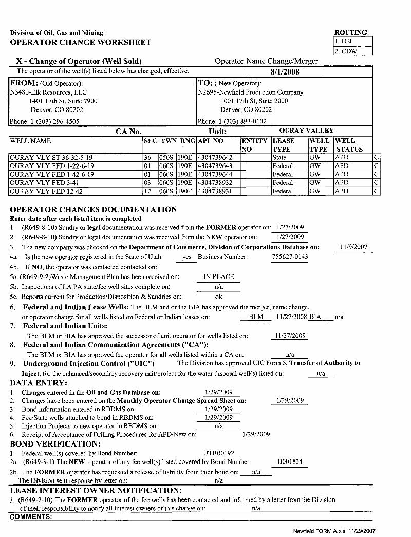
Division of Oil, Gas and Mining ROUTINGOPERATOR CHANGE WORKSHEET 1. DJJ
X - Change of Operator (Well Sold) Operator Name Change/MergerThe operator of the well(s) listed below has changed, effective: 8/1/2008
FROM: (oldOperator): TO: ( New Operator):N3480-Elk Resources, LLC N2695-Newfield Production Company
1401 17th St, Suite 7900 1001 17th St, Suite 2000Denver, CO 80202 Denver, CO 80202
Phone: 1 (303) 296-4505 Phone: 1 (303) 893-0102
CA No. Unit: OURAY VALLEY
WELL NAME SEC TWN RNG API NO ENTITY LEASE WELL WELLNO TYPE TYPE STATUS
OURAY VLY ST 36-32-5-19 36 050S 190E 4304739642 State GW APD COURAY VLY FED 1-22-6-19 01 060S 190E 4304739643 Federal GW APD COURAY VLY FED 1-42-6-19 01 060S 190E 4304739644 Federal GW APD COURAY VLY FED 3-41 03 060S 190E 4304738932 Federal GW APD COURAY VLY FED 12-42 12 060S 190E 4304738931 Federal GW APD C
OPERATOR CHANGES DOCUMENTATIONEnter date after each listed item is completed1. (R649-8-10) Sundry or legal documentation was received from the FORMER operator on: 1/27/20092. (R649-8-10) Sundry or legal documentation was received from the NEW operator on: 1/27/20093. The new company was checked on the Department of Commerce, Division of Corporations Database on: 11/9/20074a. Is the new operator registered in the State of Utah: yes Business Number: 755627-0143
4b. If NO, the operator was contacted contacted on:
5a. (R649-9-2)Waste Management Plan has been received on: IN PLACE5b. Inspections of LA PA state/fee well sites complete on: n/a5c. Reports current for Production/Disposition & Sundries on: ok
6. Federal and Indian Lease Wells: The BLM and or the BIA has approved the merger, name change,or operator change for all wells listed on Federal or Indian leases on: BLM I1/27/2008 BIA n/a
7. Federal and Indian Units:The BLM or BIA has approved the successor of unit operator for wells listed on: 11/27/2008
8. Federal and Indian Communization Agreements ("CA"):The BLM or BIA has approved the operator for all wells listed within a CA on: n/a
9. Underground Injection Control ("UIC") The Division has approved UIC Form 5, Transfer of Authority toInject, for the enhanced/secondary recovery unit/project for the water disposal well(s) listed on: n/a
DATA ENTRY:1. Changes entered in the Oil and Gas Database on: 1/29/20092. Changes have been entered on the Monthly Operator Change Spread Sheet on: 1/29/20093. Bond information entered in RBDMS on: 1/29/20094. Fee/State wells attached to bond in RBDMS on: 1/29/20095. Injection Projects to new operator in RBDMS on: n/a6. Receipt of Acceptance of Drilling Procedures for APD/New on: 1/29/2009BOND VERIFICATION:1. Federal well(s) covered by Bond Number: UTB001922a. (R649-3-1) The NEW operator of any fee well(s) listed covered by Bond Number B001834
2b. The FORMER operator has requested a release of liability from their bond on: n/aThe Division sent response by letter on: n/a
LEASE INTEREST OWNER NOTIFICATION:3. (R649-2-10) The FORMER operator of the fee wells has been contacted and informed by a letter from the Division
of their responsibility to notify all interest owners of this change on: n/aCOMMENTS:
Newfield FORMA.xls
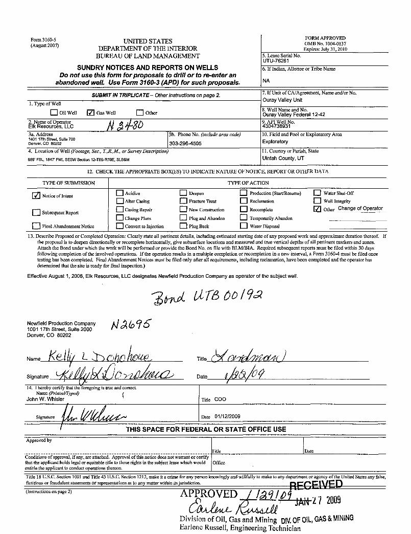
Fonn 3 0 UNITED STATES oOMN 10 -
3D7ugu DEPARTMENT OF THE INTERIOR Expires: July 31, 2010
BUREAU OF LAND MANAGEMENT 5. Lease Serial No.UTU-76261
SUNDRY NOTICES AND REPORTS ON WELLS 6.IfIndian, Allotteeor Tribe NameDo not use this form for proposals to driH or to re-enter an
abandoned weH. Use Form 3160-3 (APD) for such proposals. NA
SUBMITIN TRIPLICATE- Other instructions on page 2 7. If Unit of CA/Agreement, Name and/or No.Ouray Valley Unit
1. Type of Well
Oil Well Gas Well Other 8 NZeeyndNeI 12-42
2. Name of Operator i i 9. API Well No.Elk Resources, LLC 43047389313a. Address 3b. Phone No. (include area code) 10. Field and Pool or ExploratoryArea1401 17th Street, Suite 700Denver, CO 80202 303-296-4505 Exploratory
4. Location of Well (Footage, Sec., T.,R.,M., or Survey Description) 11. Country or Parish, State
859' FSL, 1847' FWLSESW Section 12-T6S-R19E, SLB&M Uintah County, UT
12. CHECK THE APPROPRIATE BOX(ES) TO INDICATE NATURE OF NOTICE, REPORT OR OTHER DATA
TYPE OF SUBMISSION TYPE OF ACTION
Notice of Intent Acidize Deepen Production (Start/Resume) Water Shut-Off
Alter Casing Fracture Treat Reclamation Well Integrity
Subsequent ReportCasing Repair New Construction Recomplete Other Change of Operator
Change Plans Plug and Abandon Temporarily Abandon
O Final Abandonment Notice Convert to Injection Plug Back Water Disposal
13. Describe Proposed or Completed Operation: Clearly state all pertinent details, including estimated starting date of any proposed work and approximate duration thereof. Ifthe proposal is to deepen directionally or recomplete horizontally, give subsurface locations and measured and true vertical depths of all pertinent markers and zones.Attachthe Bond under which the work will be performed or provide the Bond No. on file with BLM/BIA. Required subsequent reports must be filed within 30 daysfollowingcompletion of the involved operations. If the operation results in a multiple completion or recompletion in a new interval, a Form 3160-4 must be filed oncetestinghas been completed. Final Abandonment Notices must be filedonly after all requirements, including reclamation, have been completed and the operator hasdetermined that the site is ready for final inspection.)
Effective August 1, 2008, Elk Resources, LLCdesignates Newfield Production Company as operator of the subject well.
Newfield Production Company1001 17th Street, Suite 2000Denver, CO 80202
Name Title /Î
Signature Date
14. I hereby certify that the foregoing is true and correct.Name (Printed/Typed)
John W.aWhisler TDatee
1 2/2009
THIS SPACE FOR FEDERAL OR STATE OFFICE USE
Approved by
fitle DateConditions of approval, if any, are attached. Approval of this notice does not warrant or certifythat the applicant holds legal or equitable title to those rights in thesubject lease which would Officeentitle the applicant to conduct operations thereon.
Title 18 U.S.C. Section 1001 and Title 43 U.S.C. Section 1212, make it a crime for any person knowingly and willfully to make to any department or agency of theUnited States any false,fictitious or fraudulent statements or representations as to any matter within its jurisdiction RECElVED(Instructions on page 2) A O D
27 2009Division of Oil, Gas and Mining OROFOlL,GAS&MININGEarlene Russell, Engineering
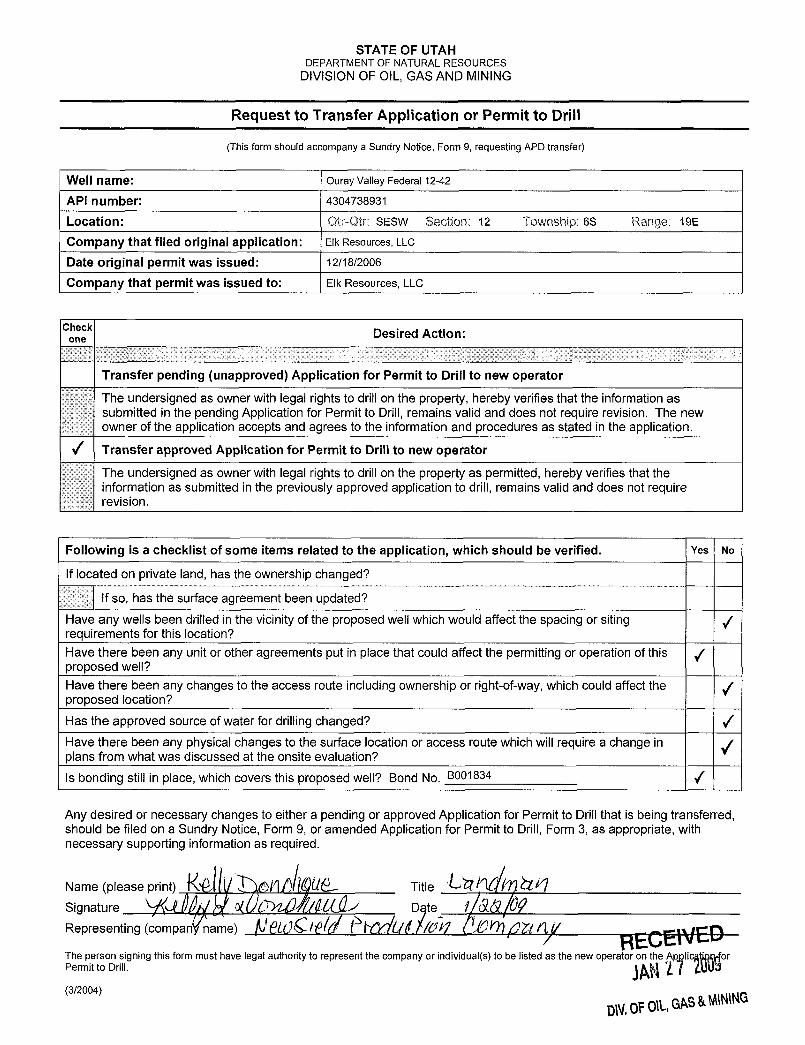
STATE OF UTAHDEPARTMENT OF NATURAL RESOURCES
DIVISIONOF OIL, GAS AND MINING
Request to Transfer Application or Permit to Drill
(This form should accompany a Sundry Notice, Form 9, requesting APD transfer)
Well name: Ouray Valley Federal 12-42
API number: 4304738931
Location: Qtr-Qtr: SESW Section: 12 Township: 6S Range: 19E
Company that filed original application: Elk Resources, LLC
Date original permit was issued: 12/18/2006
Company that permit was issued to: Elk Resources, LLC
Coheck Desired Action:
Transfer pending (unapproved) Application for Permit to Drill to new operator
The undersigned as owner with legal rights to drillon the property, hereby verifies that the information assubmitted in the pending Application for Permit to Drill, remains valid and does not require revision. The newowner of the application accepts and agrees to the information and procedures as stated in the application.
/ Transfer approved Application for Permit to Drill to new operator
The undersigned as owner with legal rights to drill on the property as permitted, hereby verifies that theinformation as submitted in the previously approved application to drill, remains valid and does not requirerevision.
Following is a checklist of some items related to the application, which should be verified. Yes No
If located on private land, has the ownership changed?
If so, has the surface agreement been updated?Have any wells been drilled in the vicinityof the proposed well which would affect the spacing or sitingrequirements for this location?Have there been any unit or other agreements put in place that could affect the permitting or operation of this |proposed well?Have there been any changes to the access route including ownership or right-of-way,which could affect theproposed location?Has the approved source of water for drillingchanged?Have there been any physical changes to the surface location or access route which willrequire a change inplans from what was discussed at the onsite evaluation?Is bonding still in place, which covers this proposed well? Bond No. B001834
Any desired or necessary changes to either a pending or approved Application for Permit to Drillthat is being transferred,should be filed on a Sundry Notice, Form 9, or amended Application for Permit to Drill, Form 3, as appropriate, withnecessary supporting information as required.
Name (please print) 46|) Û Title 11 AQSignature 0( C / D teRepresenting (company name) ÑÊLÚS/6 ÜÊt/U-Ñ
ÁÖ Oft yt-GENEDThe person signing this form must have legal authority to represent the company or individual(s) to be listed as the new operator on the Ap lic orPermit to Drill.
(3/2004)
DN.0F01, GAS&
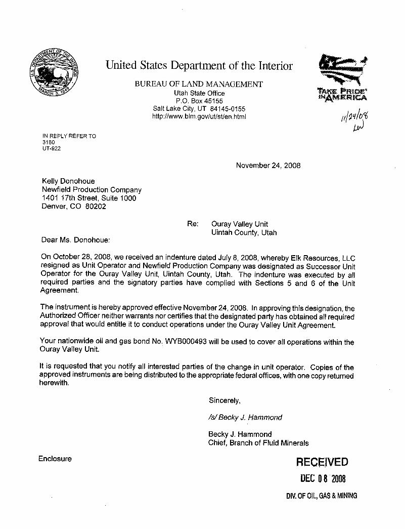
United StatesDepartment of the InteriorBUREAU OF LAND MANAGEMENT
ACH Utah State Office AKE PR DP.O. Box 45155 AM
Salt Lake City, UT 84145-0155 ¡http://www.bim.govlut/st/en.html y 9 10
IN REPLY REFER TO3180UT-922
November 24, 2008
Kelly DonohoueNewfield Production Company1401 17th Street, Suite 1000Denver, CO 80202
Re: Ouray Valley UnitUintahCounty, Utah
Dear Ms. Donohoue:
On October 28, 2008, we received an indenture dated July 8, 2008, whereby Elk Resources, LLCresigned as Unit Operator and Newfield Production Company was designated as Successor UnitOperator for the Ouray Valley Unit, Uintah County, Utah. The indenture was executed by allrequired parties and the signatory parties have complied with Sections 5 and 6 of the UnitAgreement.
The instrument is hereby approved effective November 24, 2008. Inapprovingthisdesignation, theAuthorized Officer neither warrants nor certifies thatthe designated party has obtained all requiredapproval that would entitle it to conduct operations under the Ouray Valley Unit Agreement.
Your nationwide oil and gas bond No. WYBOOO493willbe used to cover all operations withintheOuray Valley Unit.
It is requested that you notify all interested parties of the change in unit operator. Copies of theapproved instruments are being distributed totheappropriate federal offices,with one copy returnedherewith.
Sincerely,
/s/Becky J. Hammond
Becky J. HammondChief, Branch of Fluid Minerals
Enclosure RECEIVEDDECO8 2008
DIV.0FOlL,GAS&
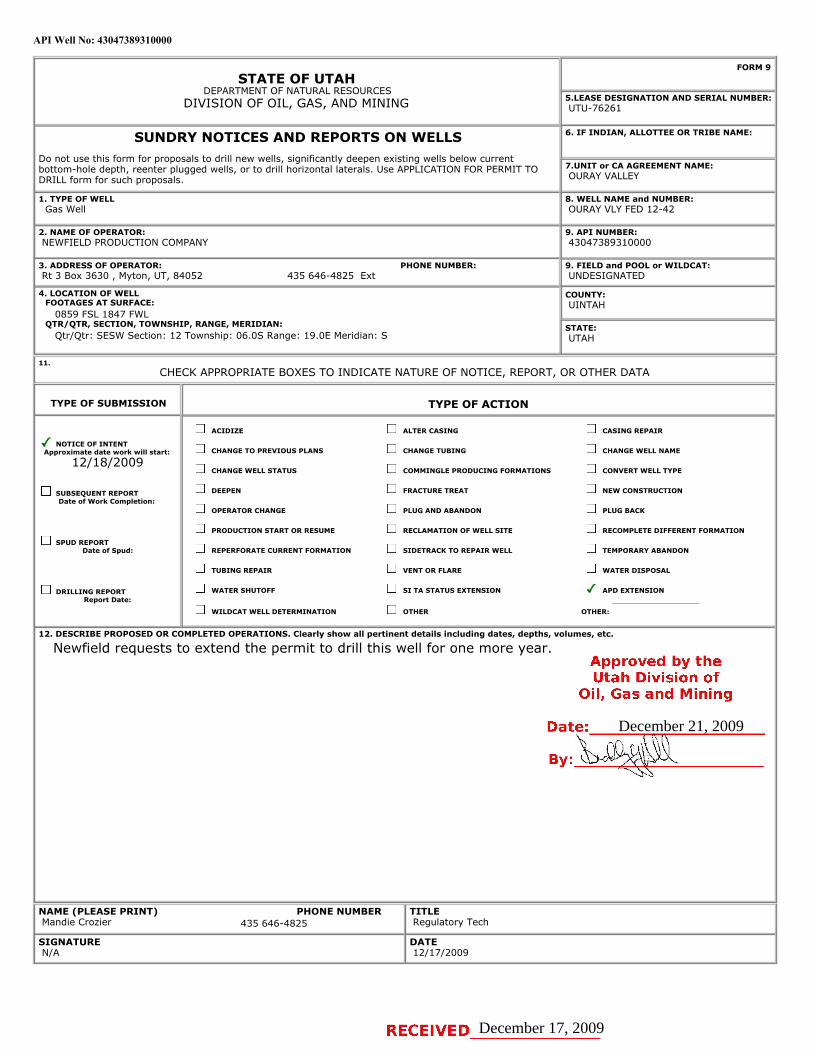
API Well No: 43047389310000
STATE OF UTAHDEPARTMENT OF NATURAL RESOURCES
DIVISION OF OIL, GAS, AND MINING
FORM 9
5.LEASE DESIGNATION AND SERIAL NUMBER: UTU-76261
SUNDRY NOTICES AND REPORTS ON WELLSDo not use this form for proposals to drill new wells, significantly deepen existing wells below currentbottom-hole depth, reenter plugged wells, or to drill horizontal laterals. Use APPLICATION FOR PERMIT TODRILL form for such proposals.
6. IF INDIAN, ALLOTTEE OR TRIBE NAME:
7.UNIT or CA AGREEMENT NAME: OURAY VALLEY
1. TYPE OF WELL Gas Well
8. WELL NAME and NUMBER: OURAY VLY FED 12-42
2. NAME OF OPERATOR: NEWFIELD PRODUCTION COMPANY
9. API NUMBER: 43047389310000
3. ADDRESS OF OPERATOR: Rt 3 Box 3630 , Myton, UT, 84052
9. FIELD and POOL or WILDCAT: UNDESIGNATED
4. LOCATION OF WELL FOOTAGES AT SURFACE: 0859 FSL 1847 FWL QTR/QTR, SECTION, TOWNSHIP, RANGE, MERIDIAN: Qtr/Qtr: SESW Section: 12 Township: 06.0S Range: 19.0E Meridian: S
COUNTY: UINTAH
STATE: UTAH
11.
CHECK APPROPRIATE BOXES TO INDICATE NATURE OF NOTICE, REPORT, OR OTHER DATA
TYPE OF SUBMISSION TYPE OF ACTION
NOTICE OF INTENTApproximate date work will start:
12/18/2009
SUBSEQUENT REPORTDate of Work Completion:
SPUD REPORTDate of Spud:
DRILLING REPORTReport Date:
ACIDIZE ALTER CASING CASING REPAIR
CHANGE TO PREVIOUS PLANS CHANGE TUBING CHANGE WELL NAME
CHANGE WELL STATUS COMMINGLE PRODUCING FORMATIONS CONVERT WELL TYPE
DEEPEN FRACTURE TREAT NEW CONSTRUCTION
OPERATOR CHANGE PLUG AND ABANDON PLUG BACK
PRODUCTION START OR RESUME RECLAMATION OF WELL SITE RECOMPLETE DIFFERENT FORMATION
REPERFORATE CURRENT FORMATION SIDETRACK TO REPAIR WELL TEMPORARY ABANDON
TUBING REPAIR VENT OR FLARE WATER DISPOSAL
WATER SHUTOFF SI TA STATUS EXTENSION APD EXTENSION
WILDCAT WELL DETERMINATION OTHER OTHER:
12. DESCRIBE PROPOSED OR COMPLETED OPERATIONS. Clearly show all pertinent details including dates, depths, volumes, etc.
Newfield requests to extend the permit to drill this well for one more year.
NAME (PLEASE PRINT) Mandie Crozier
TITLE Regulatory Tech
SIGNATURE N/A
DATE 12/17/2009
PHONE NUMBER:435 646-4825 Ext
PHONE NUMBER435 646-4825
December 17, 2009
December 21, 2009
iPI Well No: 43047389310000
FORM 9
STATE OF UTAHDEPARTMENT OF NATURAL RESOURCES
DIVISION OF OIL, GAS, AND MINING EASE D6ESIGNATION AND SERIAL NUMBER:
SUNDRY NOTICES AND REPORTS ON WELLS 6. IF INDIAN, ALLOTTEE OR TRIBE NAME:
Do not use this form for proposals to drill new wells, significantly deepen e×isting wells below currentbottom-hole depth, reenter plugged wells, or to drill horizontal laterals. Use APPLICATION FOR PERMIT TO 7.UNIT or CA AGREEMENT NAME:
DRILL form for such proposals. OURAY VALLEY
1. TYPE OF WELL 8. WELL NAME and NUMBER:Gas Well OURAY VLY FED 12-42
2. NAME OF OPERATOR: 9. API NUMBER:NEWFIELD PRODUCTION COMPANY 43047389310000
3. ADDRESS OF OPERATOR: PHONE NUMBER: 9. FIELD and POOL or WILDCAT:Rt 3 Box 3630 , Myton, UT, 84052 435 646-4825 Ext UNDESIGNATED
4.LOCATIONOFWELL COUNTY:FOOTAGES AT SURFACE: UINTAH
0859 FSL 1847 FWLQTR/QTR, SECTION, TOWNSHIP, RANGE, MERIDIAN: STATE:
Qtr/Qtr: SESW Section: 12 Township: 06.05 Range: 19.0E Meridian: 5 UTAH
11.CHECK APPROPRIATE BOXES TO INDICATE NATURE OF NOTICE, REPORT, OR OTHER DATA
TYPE OF SUBMISSION TYPE OF ACTION
ACIDIZE ALTER CASING CASING REPAIR
/ NOTICE OF INTENTApproximate date work will start: CHANGE TO PREVIOUS PLANS CHANGE TUBING CHANGE WELL NAME
12/18/2009CHANGE WELL STATUS COMMINGLE PRODUCING FORMATIONS CONVERT WELL TYPE
SUBSEQUENT REPORT DEEPEN FRACTURE TREAT NEW CONSTRUCTIONDate of Work Completion:
OPERATOR CHANGE PLUG AND ABANDON PLUG BACK
PRODUCTION START OR RESUME RECLAMATION OF WELL SITE RECOMPLETE DIFFERENT FORMATION
SPUD REPORTDate of Spud: REPERFORATE CURRENT FORMATION SIDETRACK TO REPAIR WELL TEMPORARY ABANDON
TUBING REPAIR VENT OR FLARE WATER DISPOSAL
DRILLING REPORT WATER SHUTOFF SI TA STATUS EXTENSION APD EXTENSIONReport Date:
WILDCAT WELL DETERMINATION OTHER OTHER:
12. DESCRIBE PROPOSED OR CC MPLETED OPERATIONS. Clearly show all pertinent details including dates, depths, volumes, etc.
Newfield requests to extend the permit to drill this well for one more year.Approved by theUtah Division of
Oil, Gas and Mining
Dat·e r 21, 2009
NAME (PLEASE PRINT) PHONE NUMBER TITLEMandie Crozier 435 646-4825 Regulatory Tech
SIGNATURE DATEN/A 12/17/2009
RECEIVED December 17,
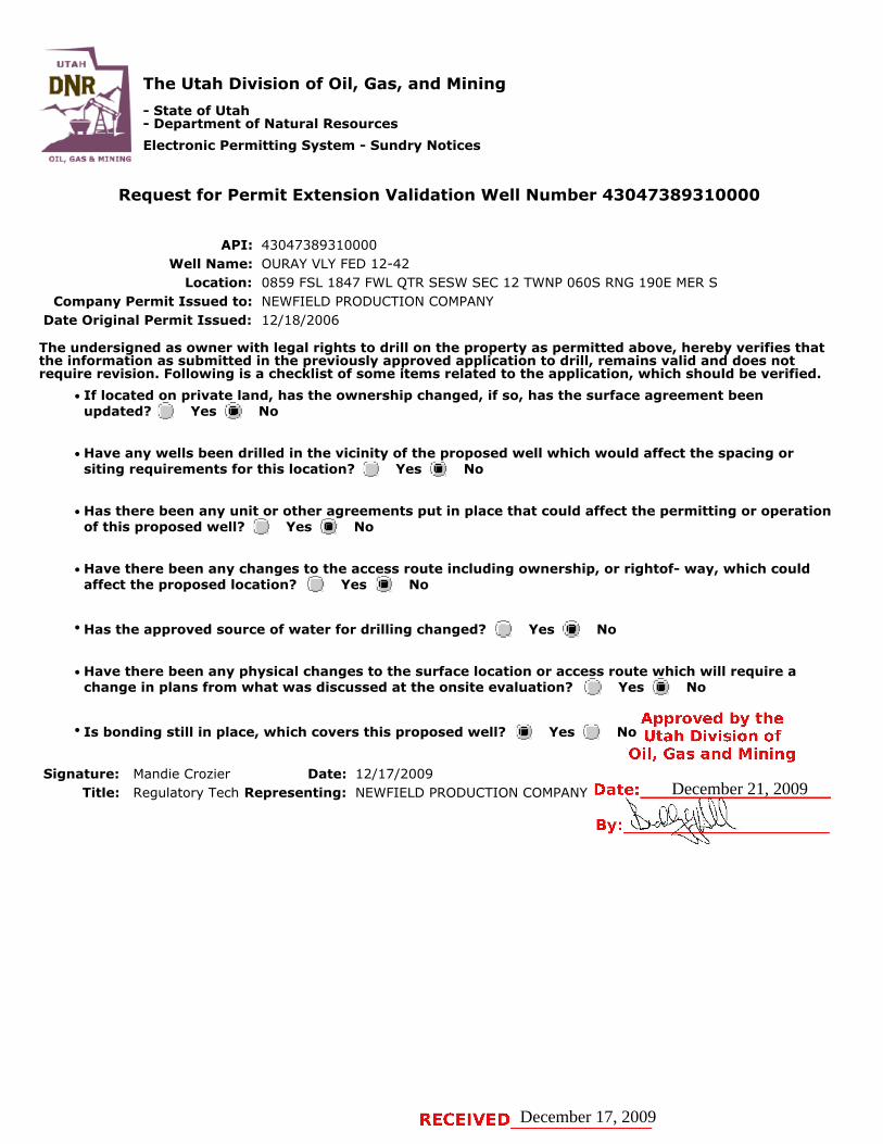
The Utah Division of Oil, Gas, and Mining
- State of Utah- Department of Natural Resources
Electronic Permitting System - Sundry Notices
Request for Permit Extension Validation Well Number 43047389310000
API: 43047389310000Well Name: OURAY VLY FED 12-42
Location: 0859 FSL 1847 FWL QTR SESW SEC 12 TWNP 060S RNG 190E MER SCompany Permit Issued to: NEWFIELD PRODUCTION COMPANY
Date Original Permit Issued: 12/18/2006
The undersigned as owner with legal rights to drill on the property as permitted above, hereby verifies thatthe information as submitted in the previously approved application to drill, remains valid and does notrequire revision. Following is a checklist of some items related to the application, which should be verified.
If located on private land, has the ownership changed, if so, has the surface agreement beenupdated? Yes No
Have any wells been drilled in the vicinity of the proposed well which would affect the spacing orsiting requirements for this location? Yes No
Has there been any unit or other agreements put in place that could affect the permitting or operationof this proposed well? Yes No
Have there been any changes to the access route including ownership, or rightof- way, which couldaffect the proposed location? Yes No
Has the approved source of water for drilling changed? Yes No
Have there been any physical changes to the surface location or access route which will require achange in plans from what was discussed at the onsite evaluation? Yes No
Is bonding still in place, which covers this proposed well? Yes No
Signature: Mandie Crozier Date: 12/17/2009
Title: Regulatory Tech Representing: NEWFIELD PRODUCTION COMPANY
December 17, 2009
December 21, 2009
UTAH
DNR The Utah Division of Oil, Gas, and Mining'
- State of Utah- Department of Natural ResourcesElectronic Permitting System - Sundry Notices
OTI GAS MlNTNG
Request for Permit Extension Validation Well Number 43047389310000
API: 43047389310000Well Name: OURAY VLY FED 12-42
Location: 0859 FSL 1847 FWL QTR SESW SEC 12 TWNP 0605 RNG 190E MER SCompany Permit Issued to: NEWFIELD PRODUCTION COMPANY
Date Original Permit Issued: 12/18/2006
The undersigned as owner with legal rights to drill on the property as permitted above, hereby verifies thatthe information as submitted in the previously approved application to drill, remains valid and does notrequire revision. Following is a checklist of some items related to the application, which should be verified.
•If located on private_land, has the ownership changed, if so, has the surface agreement beenupdated? I___|I Yes I_Ð_I No
• Have any wells been drilled in the vicinity of the_proposed well which would affect the spacing orsiting requirements for this location? I:___) Yes _®_) No
• Has there been any unit or other agreements put in place that could affect the permitting or operationof this proposed well? I i Yes i i No
• Have there been any changes to the access route including ownership, or rightof- way, which couldaffect the proposed location? I___) Yes I _I No
• Has the approved source of water for drilling changed? I __I Yes i i No
• Have there been any physical changes to the surface location or access route which will require achange in plans from what was discussed at the onsite evaluation? I___I Yes I®I No
Approved by the•Is bonding still in place, which covers this proposed well? I§|I Yes i i No Utah Division of
Oil, Gas and MiningSignature: Mandie Crozier Date: 12/17/2009
Title: Regulatory Tech Representing: NEWFIELD PRODUCTION COMPANY Date: December 21, 2009
By:
RECEIVED December 17,

API Well No: 43047389310000
STATE OF UTAHDEPARTMENT OF NATURAL RESOURCES
DIVISION OF OIL, GAS, AND MINING
FORM 9
5.LEASE DESIGNATION AND SERIAL NUMBER: UTU-76261
SUNDRY NOTICES AND REPORTS ON WELLSDo not use this form for proposals to drill new wells, significantly deepen existing wells below currentbottom-hole depth, reenter plugged wells, or to drill horizontal laterals. Use APPLICATION FOR PERMIT TODRILL form for such proposals.
6. IF INDIAN, ALLOTTEE OR TRIBE NAME:
7.UNIT or CA AGREEMENT NAME: OURAY VALLEY
1. TYPE OF WELL Gas Well
8. WELL NAME and NUMBER: OURAY VLY FED 12-42
2. NAME OF OPERATOR: NEWFIELD PRODUCTION COMPANY
9. API NUMBER: 43047389310000
3. ADDRESS OF OPERATOR: PHONE NUMBER: Rt 3 Box 3630 , Myton, UT, 84052 435 646-4825 Ext
9. FIELD and POOL or WILDCAT: UNDESIGNATED
4. LOCATION OF WELL FOOTAGES AT SURFACE: 0859 FSL 1847 FWL QTR/QTR, SECTION, TOWNSHIP, RANGE, MERIDIAN: Qtr/Qtr: SESW Section: 12 Township: 06.0S Range: 19.0E Meridian: S
COUNTY: UINTAH
STATE: UTAH
11.
CHECK APPROPRIATE BOXES TO INDICATE NATURE OF NOTICE, REPORT, OR OTHER DATA
TYPE OF SUBMISSION TYPE OF ACTION
NOTICE OF INTENTApproximate date work will start:
12/18/2010
SUBSEQUENT REPORTDate of Work Completion:
SPUD REPORTDate of Spud:
DRILLING REPORTReport Date:
ACIDIZE ALTER CASING CASING REPAIR
CHANGE TO PREVIOUS PLANS CHANGE TUBING CHANGE WELL NAME
CHANGE WELL STATUS COMMINGLE PRODUCING FORMATIONS CONVERT WELL TYPE
DEEPEN FRACTURE TREAT NEW CONSTRUCTION
OPERATOR CHANGE PLUG AND ABANDON PLUG BACK
PRODUCTION START OR RESUME RECLAMATION OF WELL SITE RECOMPLETE DIFFERENT FORMATION
REPERFORATE CURRENT FORMATION SIDETRACK TO REPAIR WELL TEMPORARY ABANDON
TUBING REPAIR VENT OR FLARE WATER DISPOSAL
WATER SHUTOFF SI TA STATUS EXTENSION APD EXTENSION
WILDCAT WELL DETERMINATION OTHER OTHER:
12. DESCRIBE PROPOSED OR COMPLETED OPERATIONS. Clearly show all pertinent details including dates, depths, volumes, etc.
Newfield proposes to extend the Application for Permit to Drill this well for oneyear.
NAME (PLEASE PRINT) PHONE NUMBER Mandie Crozier 435 646-4825
TITLE Regulatory Tech
SIGNATURE N/A
DATE 12/13/2010
December 13, 2010
12/13/2010
iPI Well No: 43047389310000
FORM 9
STATE OF UTAHDEPARTMENT OF NATURAL RESOURCES
DIVISION OF OIL, GAS, AND MINING 5.LEASE D6ESIGNATION AND SERIAL NUMBER:
SUNDRY NOTICES AND REPORTS ON WELLS 6. IF INDIAN, ALLOTTEE OR TRIBE NAME:
Do not use this form for proposals to drill new wells, significantly deepen e×isting wells below currentbottom-hole depth, reenter plugged wells, or to drill horizontal laterals. Use APPLICATION FOR PERMIT TO 7.UNIT or CA AGREEMENT NAME:
DRILL form for such proposals. OURAY VALLEY
1. TYPE OF WELL 8. WELL NAME and NUMBER:Gas Well OURAY VLY FED 12-42
2. NAME OF OPERATOR: 9. API NUMBER:NEWFIELD PRODUCTION COMPANY 43047389310000
3. ADDRESS OF OPERATOR: PHONE NUMBER: 9. FIELD and POOL or WILDCAT:Rt 3 Box 3630 , Myton, UT, 84052 435 646-4825 Ext UNDESIGNATED
4.LOCATIONOFWELL COUNTY:FOOTAGES AT SURFACE: UINTAH
0859 FSL 1847 FWLQTR/QTR, SECTION, TOWNSHIP, RANGE, MERIDIAN: STATE:
Qtr/Qtr: SESW Section: 12 Township: 06.05 Range: 19.0E Meridian: S UTAH
11.CHECK APPROPRIATE BOXES TO INDICATE NATURE OF NOTICE, REPORT, OR OTHER DATA
TYPE OF SUBMISSION TYPE OF ACTION
ACIDIZE ALTER CASING CASING REPAIR
NOTICE OF INTENTApproximate date work will start: CHANGE TO PREVIOUS PLANS CHANGE TUBING CHANGE WELL NAME
12/18/2010CHANGE WELL STATUS COMMINGLE PRODUCING FORMATIONS CONVERT WELL TYPE
SUBSEQUENT REPORT DEEPEN FRACTURE TREAT NEW CONSTRUCTIONDate of Work Completion:
OPERATOR CHANGE PLUG AND ABANDON PLUG BACK
PRODUCTION START OR RESUME RECLAMATION OF WELL SITE RECOMPLETE DIFFERENT FORMATION
O SPUD REPORTDate of Spud: REPERFORATE CURRENT FORMATION SIDETRACK TO REPAIR WELL TEMPORARY ABANDON
TUBING REPAIR VENT OR FLARE WATER DISPOSAL
DRILLING REPORT WATER SHUTOFF SI TA STATUS EXTENSION APD EXTENSIONReport Date:
WILDCAT WELL DETERMINATION OTHER OTHER:
12. DESCRIBE PROPOSED OR CC MPLETED OPERATIONS. Clearly show all pertinent details including dates, depths, volumes, etc.
Newfield proposes to extend the Application for Permit to Drill this well for oneyear. Approved by the
Utah Division ofOil, Gas and Mining
Date: 12/13/2010
By:
NAME (PLEASE PRINT) PHONE NUMBER TITLEMandie Crozier 435 646-4825 Regulatory Tech
SIGNATURE DATEN/A 12/13/2010
RECEIVED December 13,
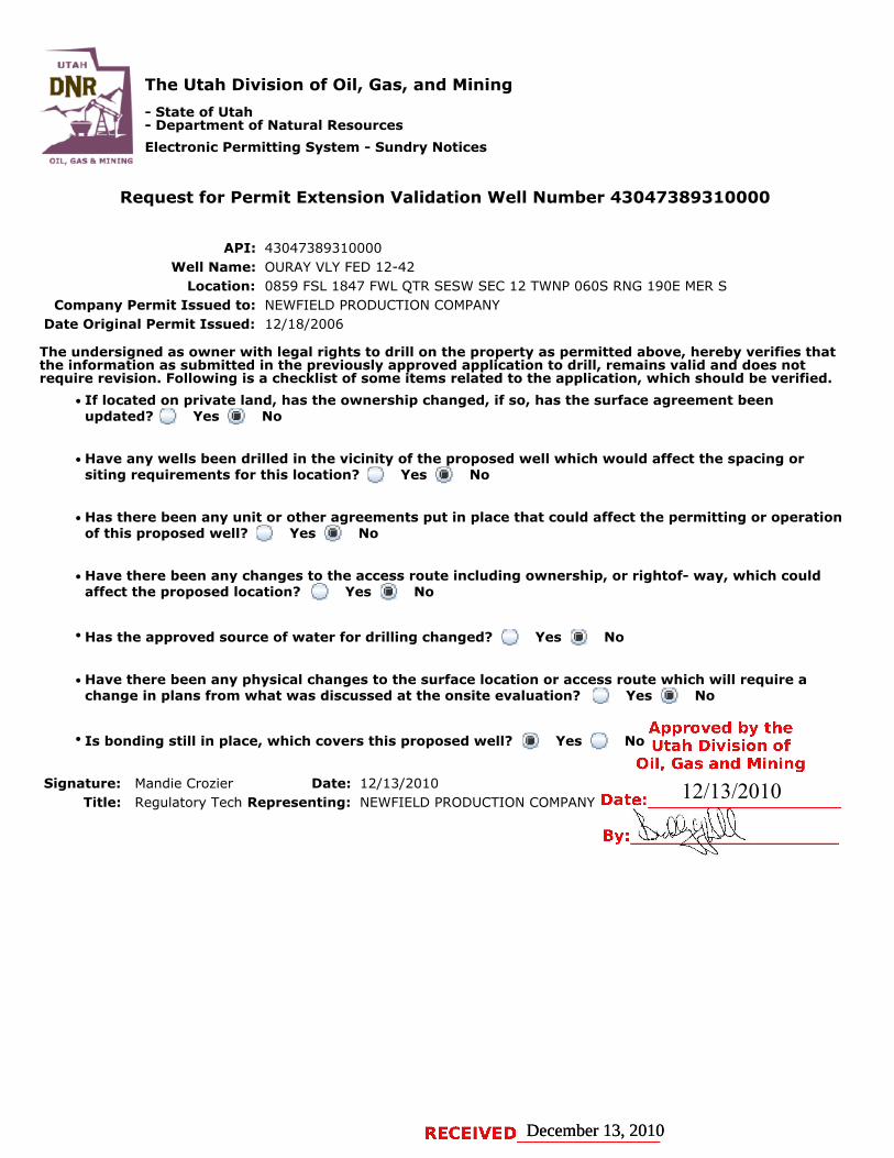
The Utah Division of Oil, Gas, and Mining
- State of Utah- Department of Natural Resources
Electronic Permitting System - Sundry Notices
Request for Permit Extension Validation Well Number 43047389310000
API: 43047389310000Well Name: OURAY VLY FED 12-42
Location: 0859 FSL 1847 FWL QTR SESW SEC 12 TWNP 060S RNG 190E MER SCompany Permit Issued to: NEWFIELD PRODUCTION COMPANY
Date Original Permit Issued: 12/18/2006
The undersigned as owner with legal rights to drill on the property as permitted above, hereby verifies thatthe information as submitted in the previously approved application to drill, remains valid and does notrequire revision. Following is a checklist of some items related to the application, which should be verified.
If located on private land, has the ownership changed, if so, has the surface agreement beenupdated? Yes No
Have any wells been drilled in the vicinity of the proposed well which would affect the spacing orsiting requirements for this location? Yes No
Has there been any unit or other agreements put in place that could affect the permitting or operationof this proposed well? Yes No
Have there been any changes to the access route including ownership, or rightof- way, which couldaffect the proposed location? Yes No
Has the approved source of water for drilling changed? Yes No
Have there been any physical changes to the surface location or access route which will require achange in plans from what was discussed at the onsite evaluation? Yes No
Is bonding still in place, which covers this proposed well? Yes No
Signature: Mandie Crozier Date: 12/13/2010
Title: Regulatory Tech Representing: NEWFIELD PRODUCTION COMPANY
December 13, 2010December 13, 2010
12/13/2010
UTAH
DNR The Utah Division of Oil, Gas, and Mining'
- State of Utah- Department of Natural Resources
Electronic Permitting System - Sundry NoticesOTI BAS Br MlNTNG
Request for Permit Extension Validation Well Number 43047389310000
API: 43047389310000Well Name: OURAY VLY FED 12-42
Location: 0859 FSL 1847 FWL QTR SESW SEC 12 TWNP 0605 RNG 190E MER SCompany Permit Issued to: NEWFIELD PRODUCTION COMPANY
Date Original Permit Issued: 12/18/2006
The undersigned as owner with legal rights to drill on the property as permitted above, hereby verifies thatthe information as submitted in the previously approved application to drill, remains valid and does notrequire revision. Following is a checklist of some items related to the application, which should be verified.
•If located on private_land, has the ownership changed, if so, has the surface agreement beenupdated? I
_
i Yes igi No
• Have any wells been drilled in the vicinity of the_proposed well which would affect the spacing orsiting requirements for this location? :___:I Yes g:I No
• Has there been any unit or other agreements put in place that could affect the permitting or operationof this proposed well? I:_:I Yes IÏiÏ:I No
• Have there been any changes to the access route including ownership, or rightof- way, which couldaffect the proposed location? I___I Yes igi No
• Has the approved source of water for drilling changed? I_
I Yes IÎiÏI No
• Have there been any physical changes to the surface location or access route which will require achange in plans from what was discussed at the onsite evaluation? I i Yes i i No
Approved by the•Is bonding still in place, which covers this proposed well? i§i Yes i i No Utah Division ofOil, Gas and Mining
Signature: Mandie Crozier Date: 12/13/2010 12/13/2010Title: Regulatory Tech Representing: NEWFIELD PRODUCTION COMPANY Date:
RECEIVED December 13,
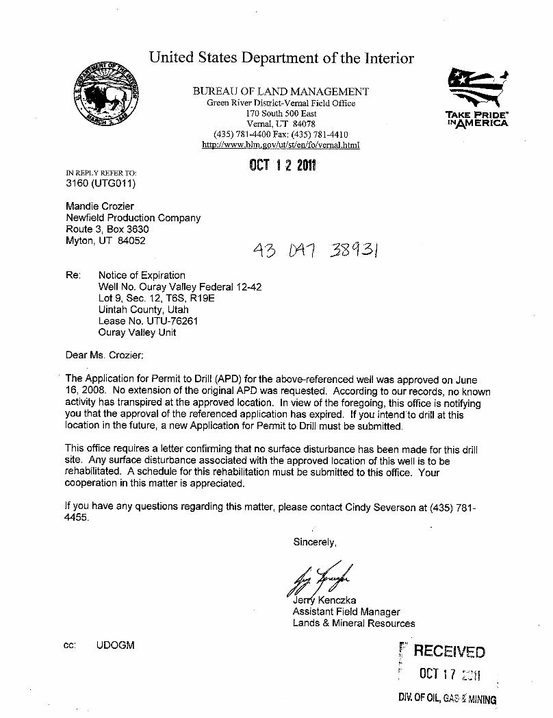
United States Department of the Interior
BUREAU OF LAND MANAGEMENTGreen River District-Vernal Field Office
170 South 500 East TAKE PRIDE'Vernal, UT 84078 INAMERICA
(435) 781-4400 Fax: (435) 781-4410http://www.blm.cov/ut/st/en/fo/vernal.html
OCT12 2011IN REPLY REFER TO:3160 (UTGO11)
Mandie CrozierNewfield Production CompanyRoute 3, Box 3630Myton, UT 84052
Re: Notice of ExpirationWell No. Ouray Valley Federal 12-42Lot 9, Sec. 12, T6S, R19EUintah County, UtahLease No. UTU-76261Ouray Valley Unit
Dear Ms. Crozier:
The Application for Permit to Drill (APD) for the above-referenced wellwas approved on June16, 2008. No extension of the originalAPD was requested. According to our records, no knownactivityhas transpiredat the approved location. In view of the foregoing, this office is notifyingyou that the approval of the referenced application has expired. Ifyou intend to drill at thislocation in the future, a new Application for Permit to Drillmust be submitted.
This office requires a letter confirmingthat no surface disturbance has been made for this drillsite. Any surface disturbance associated with the approved location of thiswell is to berehabilitated. A schedule for this rehabilitationmust be submitted to this office. Yourcooperation in this matter is appreciated.
If you have any questions regarding this matter, please contact Cindy Severson at (435) 781-4455.
Sincerely,
Jer KenczkaAssistant Field ManagerLands & Mineral Resources
cc: UDOGM RECEIVED
DIV.0F0lL,GASK
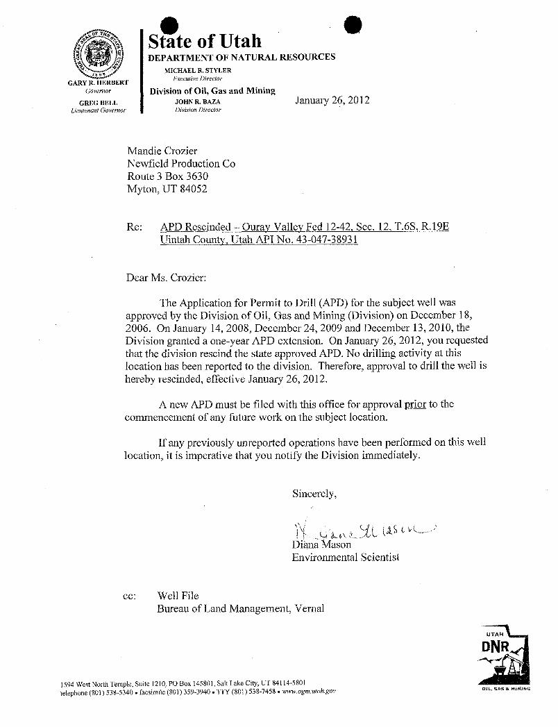
O OState of UtahDEPARTMENT OF NATURAL RESOURCES
MICHAEL R. STYLER
GARY BERT Executive Director
covernor Division of Oil, Gas and MiningGREG BELL JOHN R. BAZA January 26, 20 12
Lieutenant Governor Division Director
Mandie CrozierNewfield Production CoRoute 3 Box 3630Myton, UT 84052
Re: APD Rescinded - Ourav Vallev Fed 12-42, Sec. 12, T.6S, R.19EUintah County, Utah API No. 43-047-38931
Dear Ms. Crozier:
The Application for Permit to Drill (APD) for the subject well wasapproved by the Division of Oil, Gas and Mining (Division) on December 18,2006. On January 14, 2008, December 24, 2009 and December 13, 2010, theDivision granted a one-year APD extension. On January 26, 2012, you requestedthat the division rescind the state approved APD. No drilling activity at thislocation has been reported to the division. Therefore, approval to drill the well ishereby rescinded, effective January 26, 2012.
A new APD must be filed with this office for approval prior to thecommencement of any future work on the subject location.
If any previously unreported operations have been performed on this welllocation, it is imperative that you notify the Division immediately.
Sincerely,
Diana MasonEnvironmental Scientist
ec: Well FileBureau of Land Management, Vernal
UTAH
DNR
1594 West NorthTemple, Suite 1210, PO Box 145801, Salt Lake City, UT 84114-5801
telephone (801) 538-5340 • facsimile(801) 359-3940 •TTY (801) 538-7458 . www.ogm.utah.gov o2L, ons a
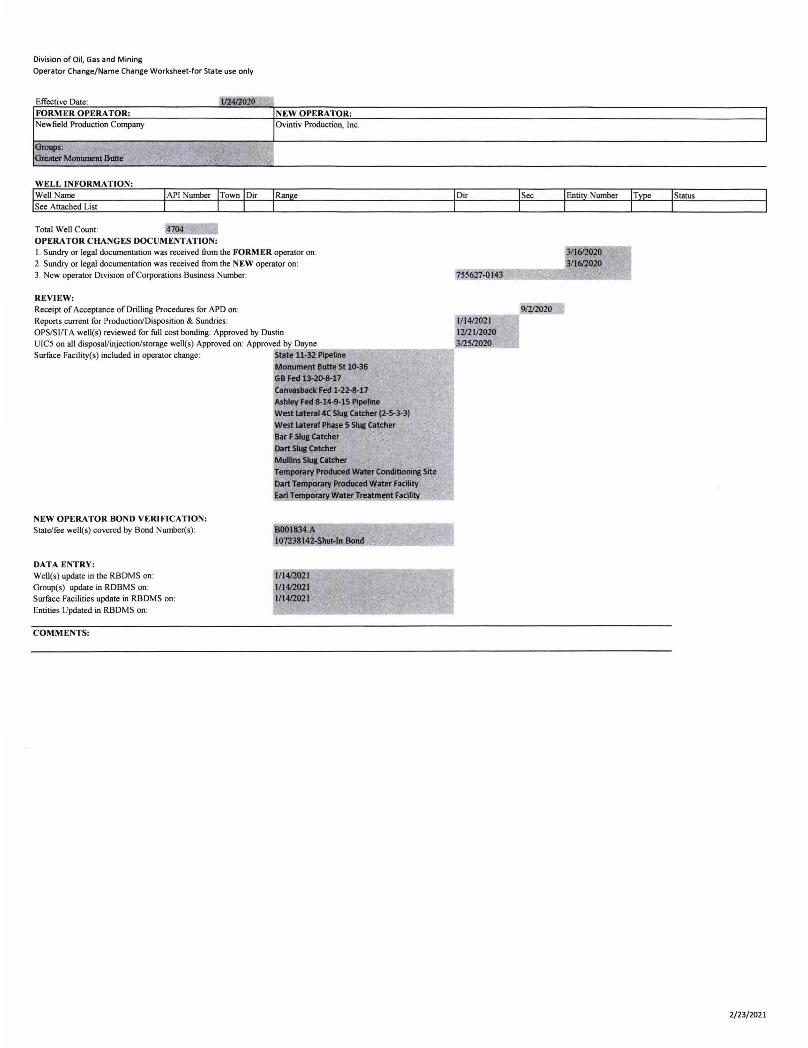
Division of Oil, Gas and Mining
Operator Change/Name Change Worksheet-for State use only
Effective Date : 112412020 -, FORMER OPERATOR: NEW OPERA TOR: Newfield Production Company Ovintiv Production, Inc.
Groups: Greater MOIIUIDeIIlBulle , ~:<,
WELL INFORMATION: WeU Name See Attached List
Total Well Count: OPERATOR CHANGES DOCUMENTATION: I. Sundry or legal documentation was received from the FORMER operator on : 2. Sundry or legal documentation was received from the NEW operator on: 3. New operator Division of Corporations Business Number:
REVIEW: Receipt of Acceptance of Drilling Procedures for APD on: Reports current for Production/Disposition & Sundries: OPS/SIIT A well(s) reviewed for fuU cost bonding: Approved by Dustin
UIC5 on all disposaVinjection/storage well(s) Approved on: Approved by Dayne Surface Facility(s) included in operator change: State 11-32 Pipetine
Monument Butte St 10-36 GB Fed 13-20-8-17 Call1l8Sback Fed 1-22-8-17 Ashley Fed 8-14-9-15 PIpeline
NEW OPERATOR BOND VERIFICATION: State/fee well(s) covered by Bond Number(s):
DATA ENTRY: Well(s) update in the RBDMS on: Group(s) update in RDBMS on: Surface Facilities update in RBDMS on: Entities Updated in RBDMS on:
COMMENTS:
west Iateral4C SIus Catcher (2-5-3-3) West latent Phase 5 Slug Catcher Bar F SIua Catcher Dart SIui CetdIer Mullins SIu& CatdIer Temporary PnIducecI Water Conditioning Site
Dart Temporary Produced w.rter FacUity EariT ra waterJreatment aclllty
1/1412021 111412021 1/1412021
755627-0143
3/1612020 ____ .... 3/1612020
.--=-=:-__ 91212020 111412021 1212112020 312512020
I
I
Status
2/23/2021
Division of Oil, Gas and MiningOperator Change/Name Change Worksheet-for State use only
Effective Date:FORMER OPERATOR: NEW OPERATOR:Newfield Production Company OvintivProduction, Inc
WELL INFORMATION:Well Name API Number Town Dir Range Dir See Entity Number Type StatusSee Attached List
Total Well Count:OPERATOR CHANGES DOCUMENTATION:1. Sundry or legaldocumentation was received from the FORMER operator on:2. Sundry or legal documentation was received fromthe NEW operator on:3. New operator Divisionof CorporationsBusiness Number:
.- V
REVIEW:Receipt of Acceptance of Drilling Procedures for APD on:Reports current for Production/Disposition & Sundries:OPS/SI/TA well(s) reviewed for fullcost bonding:Approved by DustinUICS on all disposal/injection/storage well(s) Approved on: Approved by DayneSurface Facility(s) included in operator change:
NEW OPERATOR BOND VERIFICATION:State/fee well(s) covered by BondNumber(s):
DATA ENTRY:Well(s) update in the RBDMSon:Group(s) update in RDBMSon:Surface Facilities update in RBDMS on:Entities Updated in RBDMS on:
COMMENTS:
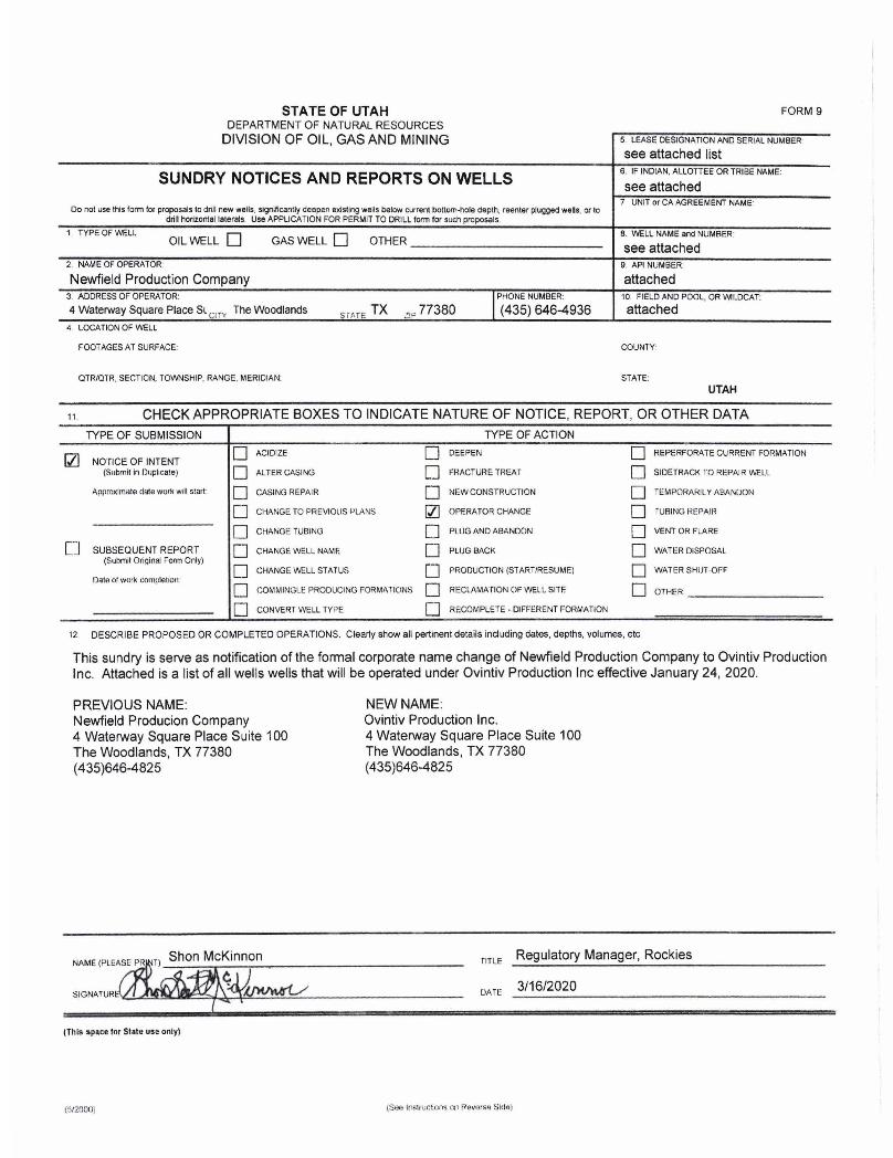
STATE OF UTAH DEPARTMENT OF NATURAL RESOURCES
DIVISION OF OIL, GAS AND MINING
SUNDRY NOTICES AND REPORTS ON WELLS
Do not use this lonn lor proposals to drill new wells, significantly deepen existing wells below current bottom-hole depth, reenter plugged wells, or to drill horizontsl lstersls. Use APPLICA nON FOR PERMIT TO DRILL form for such proposals.
1. TYPE OF WELl. OIL WELL 0 GAS WELL 0 OTHER ______________________ __
2 . NAM E OF OPERATOR:
Newfield Production Company 3. ADDRESS OF OPERATOR:
4 Waterway Square Place Sl CIT'! The Woodlands SiME TX 21P 77380 4. LOCATION OF WELL
FOOTAGES AT SURFACE:
QTR/OTR, SECTION, TOWNSHIP, RANGE, MERIDIAN:
FORM 9
5. LEASE DESIGNATION AND SERIAL NUMBER'
see attached list 6. IF INDIAN, ALLOTTEE OR TRIBE NAME:
see attached 7 UNIT or CA AGREEMENT NAME'
8. 'Mi:LL NAME and NUMBER '
see attached 9 API NUMBER:
attached 10. FIELD AND POOL, OR WILDCAT:
attached
COUNTY'
STATE:
UTAH
11 . CHECK APPROPRIATE BOXES TO INDICATE NATURE OF NOTICE, REPORT, OR OTHER DATA
TYPE OF SUBMISSION TYPE OF ACTION
Q] 0 ACIDIZE 0 DEEPEN 0 REPERFORATE CURRENT FORMATION NOTICE OF INTENT
(Submit in fluplir.ate) 0 ALTER CASING 0 fRACTURE TREAT 0 SIDETRACK 1'0 REPAIR WELL
ApproxllTlatA cjijte wOlk Will staft 0 CASING REPAIR 0 NEW CONSTRUCTION 0 TEMPORARIL Y ABANDON
D CHANGE TO PREVIOUS f'LANS fZl OPERATOR CHANGE 0 fUSING Rt:PAIf<
0 CHANGE TUBING 0 PLUG AND ABANDON 0 VENT OR FI.ARE
[ J SUBSEQUENT REPORT 0 GrIANGE WELL NAME 0 PLUG SACK 0 WATER DISPOSAL (Submit Original Form Only)
0 0 0 CHANGE WELL STATUS PRODUCTION (START/RESUME) WATER SHIJT -OFF Datn of work completion
0 0 0 COMMINGLE PRODUCING FORMATIONS RECLAMATION OF WELL SITE OTHER
0 CONVERT WELL TYPE 0 RECOMPLETE - DIFFERENT FORMATION
12 DESCRIBE PROPOSED OR COMPLETED OPERATIONS, Clearly show all pertinent details including dates , depths, VOlumes, etc,
This sundry is serve as notification of the formal corporate name change of Newfield Production Company to Ovintiv Production Inc, Attached is a list of all wells wells that will be operated under Ovintiv Production Inc effective January 24, 2020,
PREVIOUS NAME: Newfield Producion Company 4 Waterway Square Place Suite 100 The Woodlands, TX 77380 (435)646-4825
(This space ror State U5. only)
(ti/2000)
NEW NAME: Ovintiv Production Inc, 4 Waterway Square Place Suite 100 The Woodlands, TX 77380 (435)646-4825
flT l E Regulatory Manager, Rockies
DATE 3/16/2020
STATE OF UTAH FORM 9DEPARTMENT OF NATURAL RESOURCES
DIVISION OF OIL, GAS AND MINING 5 LEASEDESIGNATIONANDSERIALNUMBER
see attached list
SUNDRY NOTICES AND REPORTS ON WELLS 6 INDIANAcLhLOTdTEEORTRIBENAME:
7 UNIT or CA AGREEMENT NAMEDo not use thisform for proposals to drillnew wells, significantlydeepen existing wells below current bottom-hole depth, reenter plugged wellsor to
drillhortzontal laterals Use APPLICATIONFOR PERMITTO DRILLform for such proposals.1 TYPE OF WELI B. WELLNAMEand NUMBER
OILWELL GAS WELL OTHER see attached2 NAMEOFOPERATOR 9 APINUMBER:
NewfieldProduction Company attached3 ADDRESSOF OPERATOR: PHONE NUMBER: 10. FIELDANDPOOL, OR WILDCAT:
4 Waterway Square Place St e ,The Woodlands TX , 77380 (435) 646-4936 attached
4 LOCATIONOF WELL
FOOTAGESATSURFACE COUNTY
QTRIQTR SECTION,TOWNSHIP.RANGE.MERIDIAN: STATE:UTAH
a CHECKAPPROPRIATE BOXESTO INDICATENATUREOF NOTICE, REPORT, OR OTHER DATATYPE OF SUBMISSION TYPE OF ACTION
O ACIDIZE DEEPEN REPERFORATECURRENT FORMAT10N2 NOTICEOF INTENT(Submit in Duplicate) ALTER CASING FRACTURETREAT SlDETRACK TO REPAlR WELL
Approximate date workwillstart CASINGREPAIR NEW CONSTRUCTION TEMPORARILY ABANDON
CHANGE TO PREVIOUS PLANS OPERATOR CHANGE TURINGREPAIR
CHANGETUBING PLtJGANDABANDON VENTOR FLARE
SUBSEQUENTREPORT CHANGEWELL NAME PLUGBACK WATER DISPOSAL(Submit OriginalForm Only)
O CHANGEWELLSTATUS PRODUCTION(START/RESUME) WATER SHUT OFF
Date of work completion
O COMMINGLEPRODUCINGFORMAllONS RECLAMATIONOF WELL SITE OTHER
O CONVERT WELLTYPE RECOMPLETE- DIFFERENTFORMATION
12 DESCRIBEPROPOSED OR COMPLETEDOPERATIONS. Clearly show all pertinent details including dates, depths, volumes, etc
This sundry is serve as notificationof the formal corporate name change of Newfield Production Company to Ovintiv Productioninc. Attached is a list of all wells wells that will be operated under OvintivProduction Inc effective January 24, 2020.
PREVIOUSNAME: NEWNAME:Newfield Producion Company OvintivProduction inc.4 Waterway Square Place Suite 100 4 Waterway Square Place Suite 100The Woodlands, TX 77380 The Woodlands, TX 77380(435)646-4825 (435)646-4825
NAME(PLEASEPR T) Shon McKinnon TITLE Regulatory Manager, Rockies
SlGNATUR DATE 3/16/2020
(This space for State use only)
(6/20000 men Irstnietons no Reverse
STATE OF UTAH DEPARTMENT OF NATURAL RESOURCES
DIVISION OF OIL, GAS AND MINING
SUNDRY NOTICES AND REPORTS ON WELLS
Do not use this form lor proposals 10 drill new wells. significantly deepen existing wells below current bottom-hal. depth, reenter plugged wells, or to drill horizontal laterals. Use APPLICATION FOR PERMIT TO DRILL form for such proposals.
1. TYPE OF WEll. OIL WELL 0 GAS WELL 0 OTHER ______________________ __
2. NAME OF OPERATOR:
Newfield Production Company 3. ADDRESS OF OPERATOR:
4 Waterway Square Place SL CIT" The Woodlands smE TX 2iP 77380 4. LOCATION OF WELL
FOOTAGES AT SURFACE:
OTR/OTR. SECTION, TOWNSHIP, RANGE, MERIDIAN:
FORM 9
5. LEASE DESIGNATION AND SERIAL NUMBER
see attached list 6. IF INDIAN. ALLOTTEE OR TRIBE NAME:
see attached 7 UNIT or CA AGREEMENT NAME'
8. V',ELL NAME and NUMBER'
see attached 9 API NUMBER:
attached 10. FIELD AND POOL, OR 'M'-DCAT:
attached
COUNTY'
STATE: UTAH
11 . CHECK APPROPRIATE BOXES TO INDICATE NATURE OF NOTICE, REPORT, OR OTHER DATA
TYPE OF SUBMISSION TYPE OF ACTION
121 0 ACIDIZE 0 DEEPEN 0 REPERFORATE CURRENT FORMATION NOTICE OF INTENT
(Submit in Duplicate) 0 ALTER CASING 0 FRACTURE TREAT 0 SIDETRACK 1'0 REPAIR WELL
ApproXimate elale work will start: 0 CASING REPAIR 0 NEW CONSTRUCTION 0 TEMPORARIL Y ABANDON
0 CHANGE TO PREVIOUS PLANS 121 OPF.RATOR CHANGE 0 rUSING REPAlil
0 CHANGE TUBING [J PUJG AND ABANDON D VENT OR FLARE
[J SUBSEQUENT REPORT D OIANGE WELL NAME 0 PLUG BACK 0 WATER DISPOSAL (Submit Original Form Only)
D D 0 CHANGE WELL STATUS PRODUCTION (START/RESUME) WATER SHtH .oF" Of:lln of work completion
0 0 0 COMMINGLE PRODUCING FORMATIONS RECLAMATION OF WEl.L SITE OTHER.
0 CONVERT WELL TYPE 0 RECOMPLETE· DIFFERENT FORMATION
t2 DESCRIBE PROPOSED OR COMPLETED OPERATIONS. Clearly show all pertinent details including dates, depths, volumes, etc.
This sundry is serve as notification of the formal corporate name change of Newfield Production Company to Ovintiv Production Inc. Attached is a list of all wells wells that will be operated under Ovintiv Production Inc effective January 24, 2020.
PREVIOUS NAME: Newfield Producion Company 4 Waterway Square Place Suite 100 The Woodlands, TX 77380 (435)646-4825
(This space 1M State us. only)
(tiI2000)
NEW NAME: Ovintiv Production Inc. 4 Waterway Square Place Suite 100 The Woodlands, TX 77380 (435)646-4825
TITLE Regulatory Manager, Rockies
DArE 3/16/2020
STATE OF UTAH FORM 9DEPARTMENT OF NATURAL RESOURCES
DIVISION OF OIL, GAS AND MINING 5 LEASEDESIGNATIONANDSERIALNUMBER
see attached list
SUNDRY NOTICES AND REPORTS ON WELLS 6 FINDIAN AcLh dTEEORTRIBENAME:
7 UNITor CAAGREEMENTNAMEDo not use thls form for proposals to drill new wells. significantlydeepen existing wells below current bottom-hole depth, reenter plugged wells or to
drillhorizontal laterals Use APPLICATIONFOR PERMiTTO DRILLform for such proposais.1. TYPE OF WELL 8. WELLNAMEandNUMBER
OIL WELL GAS WELL O OTHER see attached2 NAMEOFOPERATOR 9 API NUMBER
Newfield Production Company attached3 ADDRESS OF OPERATOR: PHONENUMBER: 10 FIELDANDPOOL, OR WII.DCAT:
4 Waterway Square Place St The Woodlands s rATë TX a, 77380 (435) 646-4936 attached4 LOCATIONOF WELL
FOOTAGESAT SURFACE COUNTY
QTRIQTR. SECTION,TOWNSHIP, RANGE. MERIDIAN: STATE:UTAH
« CHECKAPPROPRIATE BOXESTO INDICATE NATURE OF NOTICE, REPORT, OR OTHER DATATYPE OF SUBMISSION TYPE OF ACTION
O ^CIDiZE DEEPEN REPERFORATECURRENT FORMAT10NNOTICE OF INTENT
(Submitin Duplicate) ALTER CASING FRACTURETREAT SIDETRACK TO REPAIR WELL
Approximate date work wd!start CASING REPAIR NEW CONSTRUCTION TEMPORARILYABANDON
CHANGE TO PREVIOUSPLANS OPERATORCHANGE TURINGREPAIR
CHANGETUBING PLUGANDABANDON VENT OR FLARE
O SUBSEQUENT REPORT CHANGEWELL NAME PLUGBACK WATERDISPOSAL(Submit OriginedForm Only)
CHANGEWELL STATUS PRODUCTION (START/RESUME) WATERSHUT4)FI
Date of work completion
O COMMINGLEPRODUCINGFORMATIONS RECLAMATION OF WELLSITE OTHER
CONVERT WELL TYPE RECOMPLETE· DIFFERENTFORMATION
12 DESCRIBE PROPOSED OR COMPLETED OPERATIONS. Clearly show all pertinentdetails including dates, depths, volumes, etc
This sundry is serve as notificationof the formal corporate name change of Newfield Production Company to OvintivProductionInc. Attached is a list of all wells wells thatwillbe operated under Ovintiv Production Inc effective January 24, 2020.
PREVIOUS NAME: NEWNAME:Newfield Producion Company OvintivProduction Inc.4 Waterway Square Place Suite 100 4 Waterway Square Place Suite 100The Woodlands, TX 77380 The Woodlands, TX77380(435)646-4825 (435)646-4825
NAME(PLEASE P T) Shon McKinnon TITLE Regulatory Manager, Rockies
SIGNATUR DATE 3/16/2020
(This space for State use only)
tS/2000; (See InstfMetons on Reverse