Embed Size (px)
Citation preview

www.delwp.vic.gov.au
Product data descriptionVicmap™ Hydro
AS/NZS ISO 19131:2008 compliant
Version 6.1 February 2018 Applies to data model 2.1 July 2009

© The State of Victoria Department of Environment, Land, Water and Planning 2018
This work is licensed under a Creative Commons Attribution 4.0 International licence. You are free to re-use the work under that licence, on the condition that you credit the State of Victoria as author. The licence does not apply to any images, photographs or branding, including the Victorian Coat of Arms, the Victorian Government logo and the Department of Environment, Land, Water and Planning (DELWP) logo. To view a copy of this licence, visit http://creativecommons.org/licenses/by/4.0/
DisclaimerThis publication may be of assistance to you but the State of Victoria and its employees do not guarantee that the publication is without flaw of any kind or is wholly appropriate for your particular purposes and therefore disclaims all liability for any error, loss or other consequence which may arise from you relying on any information in this publication.
AccessibilityIf you would like to receive this publication in an alternative format, please telephone the DELWP Customer Service Centre on 136186, email [email protected] or via the National Relay Service on 133 677 www.relayservice.com.au. This document is also available on the internet at www.delwp.vic.gov.au.
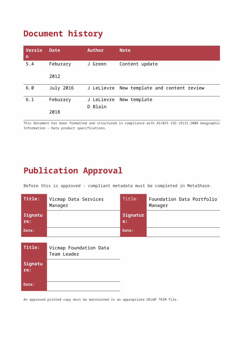
Document history
Version Date Author Note
5.4 Feburary 2012 J Green Content update
6.0 July 2016 J LeLievre New template and content review
6.1 Feburary 2018 J LeLievreD Blain
New template
This document has been formatted and structured in compliance with AS/NZS ISO 19131:2008 Geographic Information – Data product specifications.
Publication ApprovalBefore this is approved - compliant metadata must be completed in MetaShare.
Title: Vicmap Data Services Manager Title: Foundation Data Portfolio Manager
Signature: Signature:
Date: Date:
Title: Vicmap Foundation Data Team Leader
Signature:
Date:
An approved printed copy must be maintained in an appropriate DELWP TRIM file.
Table of ContentsDocument history.......................................................................................................................................... 1
Publication Approval..................................................................................................................................... 1
Table of Contents.......................................................................................................................................... 2
Overview......................................................................................................................................................... 3
Vicmap™........................................................................................................................................................ 3
Data product specification title.................................................................................................................... 3
Responsible party.......................................................................................................................................... 3
Terms and definitions.................................................................................................................................... 4
Acronyms....................................................................................................................................................... 5
Informal description of the data product.....................................................................................................6
Specification scope....................................................................................................................................... 6Level................................................................................................................................................................ 6Extent & coverage......................................................................................................................................... 6
Data product identification........................................................................................................................... 6Title................................................................................................................................................................. 6Abstract.......................................................................................................................................................... 6Topic Category............................................................................................................................................... 7
Data content and structure........................................................................................................................... 8
Data content................................................................................................................................................... 8
Feature based data........................................................................................................................................ 8
Data structure................................................................................................................................................ 8
Reference systems...................................................................................................................................... 11
Data quality.................................................................................................................................................. 11
Accuracy....................................................................................................................................................... 11
Completeness.............................................................................................................................................. 13
Logical consistency..................................................................................................................................... 13
Data capture................................................................................................................................................. 14
Data maintenance........................................................................................................................................ 14
Data product delivery.................................................................................................................................. 15
Access & licensing...................................................................................................................................... 15
Metadata....................................................................................................................................................... 15
Appendix A: Data & object models............................................................................................................16
Appendix B: Data dictionary....................................................................................................................... 17
Appendix C: Database tables..................................................................................................................... 23
Appendix D: Reference tables.................................................................................................................... 43
OverviewVicmap™ Vicmap™ is the foundation that underlies most spatial information in Victoria. This portfolio of spatial related authoritative data products, made up from individual datasets, is developed and managed by the Department of Environment, Land, Water & Planning. The information provides the foundation to Victoria’s primary mapping and spatial information systems, and is used for building business information and systems.
Vicmap is a registered trademark of the Victorian Government and is synonymous with authoritative statewide mapping since 1975. The Vicmap portfolio includes:
Vicmap AddressVicmap AdminVicmap Crown Land TenureVicmap ElevationVicmap Features of InterestVicmap HydroVicmap ImageryVicmap Index
Vicmap LiteVicmap PlanningVicmap PositionVicmap PropertyVicmap Topographic MappingVicmap TransportVicmap Vegetation
Vicmap data is supported by a collection of Reference Tables, Vicmap Reference Tables. A reference table may list the full name, description and other attributes associated with a feature code or identifier.
Further information can be found at www2.delwp.vic.gov.au/maps
Data product specification titleVicmap™ Hydro
Responsible party Department of Environment, Land, Water and Planning
PO Box 527, Melbourne VIC 3001 Australia
Product description – Vicmap Hydro Version 6.1Department of Environment, Land, Water & Planning
Terms and definitionsFor the purpose of this document, the following terms and definitions apply.
Term DefinitionANZLIC ID A unique identifier enabling metadata records to be discovered and differentiated
within a structured data library.Attribute A characteristic of a feature that may occur as a type or an instance.Custodian An organisation responsible for ensuring the accuracy, currency, distribution of their
data and the terms and conditions of access and use.Data type Specification of a value domain with operations allowed on values in this domain
Refer to AS/NZS ISO 19103Dataset Identifiable collection of data. Maybe as small as a single feature or feature attribute
contained within a larger dataset. A hardcopy map maybe considered a dataset.Refer to AS/NZS ISO 19115
Dataset series Collection of datasets sharing the same product specification, also known as a product.
Domain A well-defined set both necessary and sufficient, as everything that satisfies the definition in the set and everything that does not satisfy the definition is necessarily outside the set.Refer to ISO/TS 19103
the Department
Meaning the Department of Environment, Land, Water & Planning (DELWP).
Entity A unit of data that can be classified and have stated relationship with other entities.Feature An abstraction of real-world phenomena. A feature may occur as a type or an
instance. Feature type or instance shall be used when only one is meant.The feature structure of the feature based data model can be summarised as:feature instance = [spatial object + attribute object]
Metadata Metadata is ‘data about data’ and provides a synopsis about the data lineage, accuracy and details about access permissions.Refer to ISO 19115 Geographic information ― Metadata
Parent metadata record
Parent metadata records act as a cover note for a product that contains a dataset series for search, discovery & delivery purposes.
Persistent Feature Identifier (PFI)
The unique code provide at creation of the feature which remains until the feature is retired.
Product Dataset or dataset series that conforms to a data product specification.Quality Totality of characteristics of a product that bear on its ability to satisfy stated and
implied needs. Refer to:ISO 19113 Geographic information ― Quality principlesISO 19114 Geographic information ― Quality evaluation procedures
the State Victoria.Unique Feature identifier (UFI)
Each feature is uniquely identified and renewed with each change.
AcronymsFor the purpose of this document, the following acronyms may apply.
Acronym DefinitionAHD Australian Height Datum
DALA DELWP Data Access License Agreement
DELWP Department of Environment, Land, Water & Planning
DSV Data Search Victoria
CFA Country Fire Authority
DALA DELWP Data Access License Agreement
DELWP Department of Environment, Land, Water & Planning
FIB Forest Industry Brigade
GDA Geographic Datum Australia
GIS Geographic Information System
GNR Geographic Place Names Register
MoU Memorandum of Understanding
NES Notification for Editing Service
PIQA Property Information Quality Audit
RMSE Root-Mean-Square Error
SDM Spatial DataMart
SPOT Satellite Pour l’Observation de la Terre (French)
VGDD Victorian Government Data Directory
Product description – Vicmap Hydro Version 6.1Department of Environment, Land, Water & Planning
Informal description of the data productVicmap Hydro is a topologically structured digital data set depicting Victoria’s natural and man made
water resources including selected water related structures and coastal navigational features. Vicmap Hydro can be used in a variety of applications including, protection and conservation analyses for natural resources, impact assessment, monitoring and land analysis.
Vicmap Hydro is a framework product that forms an essential element to the map base for the State’s Topographic mapping program.
Product updates are made available weekly through the Vicmap maintenance lifecycle. The data is sourced from authoritative Custodians via the Vicmap Custodianship Program.
Specification scopeLevel Dataset series
Extent & coverageCovering statewide Victoria. Additional cross border data for Vicmap Transport is provided to DELWP under an arrangement with New South Wales and South Australia. The cross-border data extends up to 100 kilometres into New South Wales and a 1 x 1:100 000 tile into South Australia.
Data product identificationTitleVicmap™ Hydro
AbstractVicmap Hydro represents the natural and man-made water resoures for Victoria and is made up of point, line and polygon vector features in a seamless, networked and topologically structured dataset series. It is comprised of a basic framework of linear features supplemented by related point and polygon features to value add data for the water networks across the State. Attribute tables classify and describe the real-world features using code lists that can be used for search, discovery and analysis.
The following hydrographic features are contained within Vicmap Hydro: Watercourse (line)- watercourse, connector, channel, drain Water Area (polygon)- lake, flat, wetland, pondage, watercourse area Water Area Boundary (line)- shoreline, junction Water Point (point)- rapids, spring, waterfall, waterbody point
In inland and coastal areas, point and line features are used to describe various waterline related structures: Water Structure Line (line)- wharf, marina, offshore platform, breakwater, launching ramp, dam wall,
spillway, lock Water Structure Point (point)- lock, well Water Structure Area (polygon)- dam batter, spillway
Along our coastline various features exist which either aid or obstruct local navigation: Navigation Point (point)- buoy, beacon, rock, wreck Navigation line (line)- reef ledge
Depiction of coastal environmentFeatures along our coastal environment are best depicted with Vicmap Index which contains Victoria’s state boarders and coastline.
Interpretation of features such as watercourses and sea depend on the following criteria: The limit between sea and land ie. coastline is represented by the mean highwater mark (1m below
flotsam on the beach) except in areas covered by mangroves where the landward side is adopted. Note: The limit between the shoreline of internal water bodies and land is represented by the full supply level.
The use of a connector feature ceases when a watercourse area runs into the sea delineated by a junction representing coastline.
Coastal intertidal flats comprised of sand or mud, exposed at low tide form polygon areas which can extend seaward more than 100m or inland.
Small inlets with a single line stream flowing into them are usually considered part of the sea. Islands are represented by polygons coded “Island” when they are fully surrounded by sea. In inland
waters they are shown as void polygons.
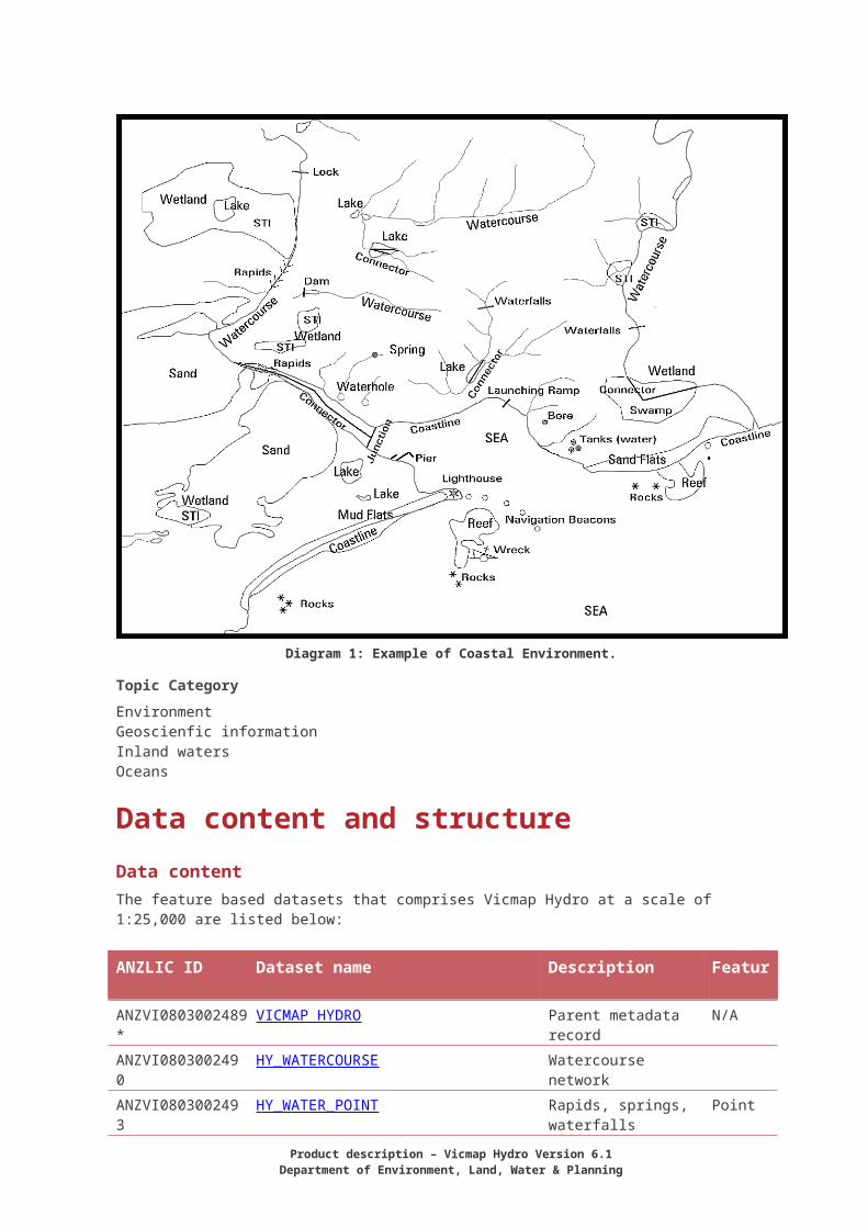
Diagram 1: Example of Coastal Environment.
Topic CategoryEnvironmentGeoscienfic informationInland watersOceans
Product description – Vicmap Hydro Version 6.1Department of Environment, Land, Water & Planning
Data content and structureData contentThe feature based datasets that comprises Vicmap Hydro at a scale of 1:25,000 are listed below:
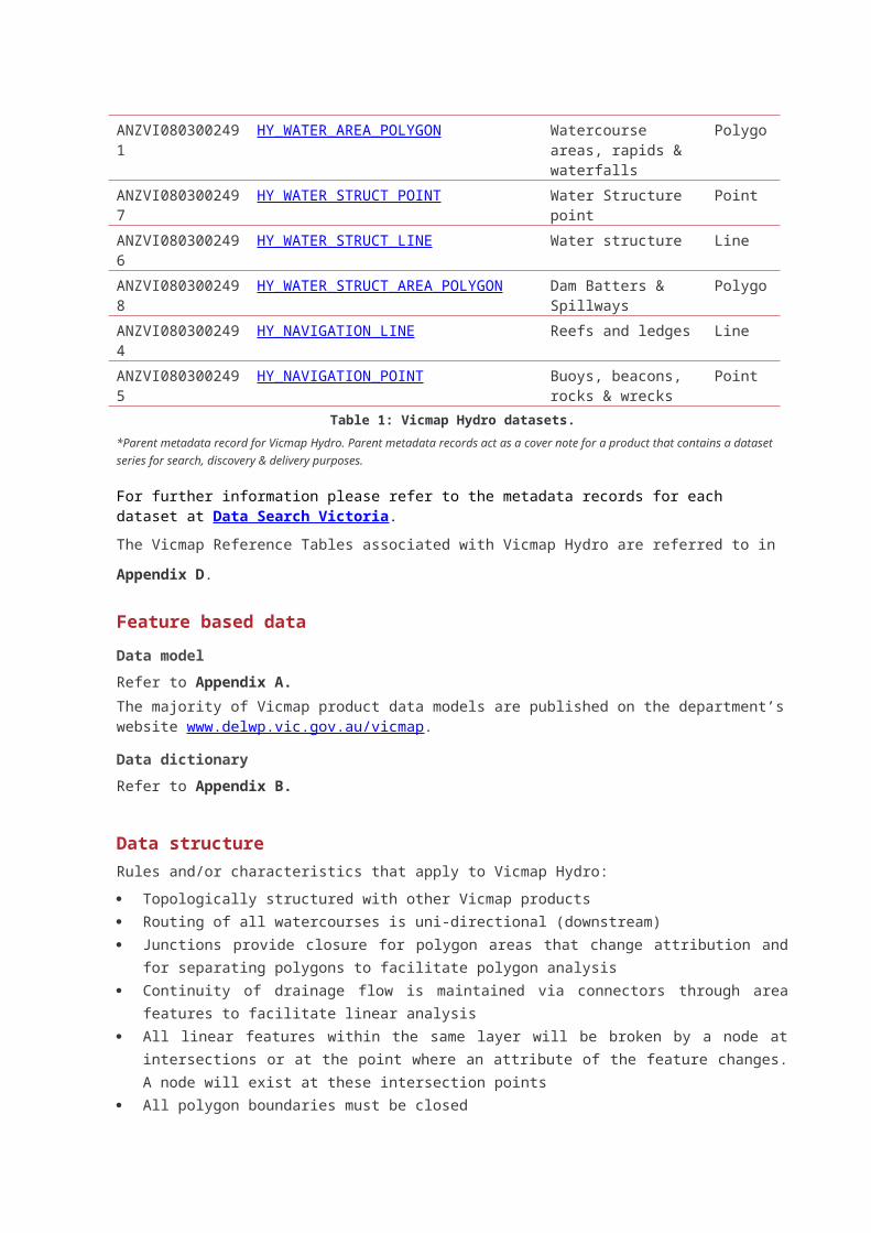
ANZLIC ID Dataset name Description Feature
ANZVI0803002489* VICMAP HYDRO Parent metadata record
N/A
ANZVI0803002490 HY_WATERCOURSE Watercourse networkANZVI0803002493 HY_WATER_POINT Rapids, springs,
waterfallsPoint
ANZVI0803002491 HY_WATER_AREA_POLYGON Watercourse areas, rapids & waterfalls
Polygon
ANZVI0803002497 HY_WATER_STRUCT_POINT Water Structure point PointANZVI0803002496 HY_WATER_STRUCT_LINE Water structure LineANZVI0803002498 HY_WATER_STRUCT_AREA_POLYGON Dam Batters &
SpillwaysPolygon
ANZVI0803002494 HY_NAVIGATION_LINE Reefs and ledges LineANZVI0803002495 HY_NAVIGATION_POINT Buoys, beacons, rocks
& wrecksPoint
Table 1: Vicmap Hydro datasets.*Parent metadata record for Vicmap Hydro. Parent metadata records act as a cover note for a product that contains a dataset series for search, discovery & delivery purposes.
For further information please refer to the metadata records for each dataset at Data Search Victoria.
The Vicmap Reference Tables associated with Vicmap Hydro are referred to in Appendix D.
Feature based data
Data modelRefer to Appendix A.The majority of Vicmap product data models are published on the department’s website www.delwp.vic.gov.au/vicmap.
Data dictionaryRefer to Appendix B.
Data structureRules and/or characteristics that apply to Vicmap Hydro:
Topologically structured with other Vicmap products Routing of all watercourses is uni-directional (downstream) Junctions provide closure for polygon areas that change attribution and for separating polygons to
facilitate polygon analysis Continuity of drainage flow is maintained via connectors through area features to facilitate linear
analysis All linear features within the same layer will be broken by a node at intersections or at the point
where an attribute of the feature changes. A node will exist at these intersection points All polygon boundaries must be closed
Every polygon feature will contain a para-centroid that may be used for the positioning of information about the feature
Confirms to national data models, ICSM Temporal Data Management:
o A Persistent Feature Identifier (PFI) is generated once for each feature at the point of creation and remains constant until a feature is retired. A PFI is unique to, and cannot be reused within a particular table. However, you may have the same PFI number in different tables but does not relate to the same feature entity, and
o The Unique Feature Identifier (UFI) is generated for each feature at the point of creation and changes with each modification or version. This allows users to track the changes made to a feature over time.
Polygon voidsPolygon features may contain an inner set of lines, holes or voids that cannot be assigned to any feature class within that layer. For example, a Lake in the Water Area layer may have in the middle of it an area of dry land. This would appear in the data as a polygon with no paracentroid.
Coincident featuresThere will be no coincident polygons, lines (whole or in part) or points of the same feature type in the data (also frequently known as double digitising). Differing features may be coincident, as may be the case where a dam wall also forms part of a dam polygon, (in these cases, the common data repeats for each feature type, and is appropriately tagged and supplied as part of each feature type)
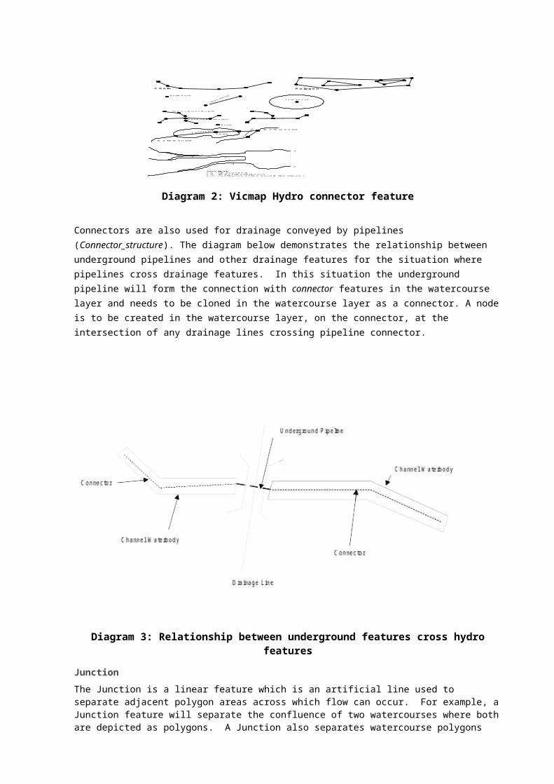
ConnectorDrainage patterns are made up of both linear (narrow streams) and polygon features (such as watercourse areas, lakes and swamps) and consequently do not constitute a rigorous linear network. To allow linear analysis of drainage networks an artificial feature called a "Connector" has been added to the data.
This Connector feature is used to connect linear watercourse features where they are separated by water areas such as lakes, swamps and watercourses depicted as area features. The points that make up this chain cannot be given any value for planimetric accuracy. The Connector will only be used if there is flow across a waterbody polygon feature. Thus, if there is only inflow to a lake and no outflow the Connector feature will not be used.
Tributary watercourses flowing into a polygon area will be linked to the areas with Connectors.
In the example below, the use of connectors ceases once the watercourse runs into a tidal area such as an estuary, bay or inlet of the sea. Connector devices carry the attributes of the watercourse they represent, not the waterbody through which they pass.
Chain Polygon
c
Same class of feature
Node of intersection
Node
Lake
Watercourse
Watercourse
North Head
Tasman Sea
a
b
c
dc
d
ef
Junctions:a,b - tile boundaryc,d - limit of tidal influencee, f - confluence of two double line streams
Diagram 2: Vicmap Hydro connector feature
Connectors are also used for drainage conveyed by pipelines (Connector_structure). The diagram below demonstrates the relationship between underground pipelines and other drainage features for the situation where pipelines cross drainage features. In this situation the underground pipeline will form the connection with connector features in the watercourse layer and needs to be cloned in the
Product description – Vicmap Hydro Version 6.1Department of Environment, Land, Water & Planning
watercourse layer as a connector. A node is to be created in the watercourse layer, on the connector, at the intersection of any drainage lines crossing pipeline connector.
Diagram 3: Relationship between underground features cross hydro features
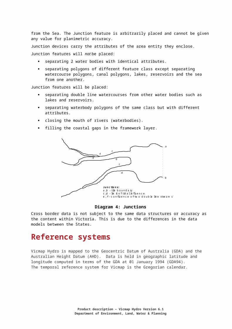
Junction The Junction is a linear feature which is an artificial line used to separate adjacent polygon areas across which flow can occur. For example, a Junction feature will separate the confluence of two watercourses where both are depicted as polygons. A Junction also separates watercourse polygons from the Sea. The Junction feature is arbitrarily placed and cannot be given any value for planimetric accuracy.
Junction devices carry the attributes of the area entity they enclose.
Junction features will not be placed:
separating 2 water bodies with identical attributes.
separating polygons of different feature class except separating watercourse polygons, canal polygons, lakes, reservoirs and the sea from one another.
Junction features will be placed:
separating double line watercourses from other water bodies such as lakes and reservoirs.
separating waterbody polygons of the same class but with different attributes.
closing the mouth of rivers (waterbodies).
filling the coastal gaps in the framework layer.
Chain Polygon
c
Same class of feature
Node of intersection
Node
Lake
Watercourse
Watercourse
North Head
Tasman Sea
a
b
c
dc
d
ef
Junctions:a,b - tile boundaryc,d - limit of tidal influencee, f - confluence of two double line streams
Diagram 4: JunctionsCross border data is not subject to the same data structures or accuracy as the content within Victoria. This is due to the differences in the data models between the States.
Reference systemsVicmap Hydro is mapped to the Geocentric Datum of Australia (GDA) and the Australian Height Datum (AHD). Data is held in geographic latitude and longitude computed in terms of the GDA at 01 January 1994 (GDA94).The temporal reference system for Vicmap is the Gregorian calendar.
Data qualityAccuracyVicmap relies heavily on Custodianship Agreements or MoUs to source its data from authoritative Custodians.
The spatial accuracy of data within a Vicmap product is where possible better than 1:25,000 and retains vertical alignment with other Vicmap datasets. Cartographic generalisation of features to facilitate presentation has been employed based on a hierarchy as mentioned in “Generalisations within the Data.” It is believed that all generalisations fall within the remaining 10% at 1.0mm or less at plot scale.
The following procedures are undertaken as normal update/maintenance routines, to ensure conformity of the data to specification:
Customised menus for data editing which provide on the fly logical consistency attribute checking as data is edited
Automated data QA processes to validate topological integrity, completeness and logical consistency. The Department reviews road name content against authoritative Custodian sources through the annual Property Information Quality Audit (PIQA).
Automated data loading routines, reflecting business rules for data population, to ensure data accuracy
Independent review of data upon loading including aspatial attributes, spatial extents and successful data load
Validation of accepted types according to approved reference tables
Adoption of ICSM guidelines for incremental updates - to assist in temporal data management (features are date-stamped)
Validation of entity PFI/UFI tags for uniqueness.
Product description – Vicmap Hydro Version 6.1Department of Environment, Land, Water & Planning
Approximately 5% of all maintenance advice notices processed are separately audited by the Department to confirm accuracy, completeness and correctness in the capture process.
Data quality pointer attributeEvery feature instance has associated with it a feature quality attribute (feature_quality_id) which is linked to a record in a Feature Quality Table.
Data quality tableThis table contains information relevant to specific features such as: mapping scale, data source, reliability dates of spatial or attribute objects, see Data Model Appendix B. The source mapping scale which indirectly provides an estimate of the horizontal positional
accuracy.The source of the data, which indicates the data capture method.
The reliability date of the spatial object (feat_reli_date) - the date of the latest original source material where the position of a particular feature was verified.
The reliability date of the attribute object (att_reli_date) - the date of the latest material used to verify at least one attribute value for a feature. This date will be updated with the date of the most current attribute every time a part of that object is updated
The contents and structure of the Data Quality Table are specified in Appendix B.
Positional accuracyThe positional accuracy of spatial data is a statistical estimate of the degree to which planimetric coordinates and elevations of features agree with their real-world values. The minimum planimetric accuracy attainable will be the sum of errors from three sources: The positional accuracy of source material; Errors due to the conversion process; Errors due to the manipulation process.
It is expressed as the standard deviation of the horizontal position of the feature that is +/-17.5m for scanned 1:25,000 scale topographic data. It is generally estimated that 90% of well defines features are within 0.7mm at 1:25,000 map scale of their true position. Vimcap Hydro now utilises imagery to verify and validate the true position of features increasing the positional accuracy of features.
Generalisations with the data Cartographic generalisation of features to facilitate presentation exist based on a hierarchy as mentioned below. Projects and ongoing maintenance of Vicmap have and will continue to improve the accuracy & presentation of features. Where features are generalised, they fall within the remaining 10% at 1.0mm or less at plot scale.Data was historically captured to 1:25,000 scale topographic specifications from compilations or negative separations. Conversion and manipulation processes have contributed to the degradation of positional accuracy of the real world spatial data. Some features have been subjected to cartographic generalisation when located on the earth’s surface so that they can be separated at the scale of map publication. To ensure cartographic clarity, one feature has been held in correct position and the rest are displaced.At capture stage, a hierarchy determined which features were held in correct position. This hierarchy(see below) has been used when one or more adjacent features would have resulted in over-printing atpublication scale. Natural features are placed higher in the hierarchy:
1. Hydrographic lines (coastline, watercourses and water bodies)2. Railways3. Principal roads4. Secondary roads
5. Minor roads, tracks6. Buildings and other point symbols7. Vegetation boundary
Mapping data generalisation River and road coincide at the scale of compilation- the road is displaced. Where two or three features are close and adjacent, one may be displaced by up to 25m at
1:25,000 scale. Such displacement must maintain the correct alignment of one feature to the other.
Point features such as buildings in close proximity to linear features are displaced in a way that retains their positional relationship relative to other features.
After displacement, these symbolised features will not remain within accuracy tolerances and thereforecannot be included in accuracy tests.
Vector data generalisation:Line string-vector specifications stipulate maximum distance between two points (0.25mm) and thinningof arcs applied according to the degree of curvature of the line strings. For three successive points, ifthe mid-point is less than 0.10mm off-line it should be discarded. Points diverging greater than 0.10mmare stored.
General rules associated with data capture determined whether features were to be drawn to scale to form polygons or were to be symbolised as a point eg. point symbols used for water areas less than 50m across in size (ground scale) otherwise drawn to scale at full supply level.
Connectors arbitrarily applied to join streams through water areas eg. connector through a lake does not follow topography.
Post capture amendments added to suit model criteria not positional accuracy eg. Stream connection to river in flat area.
CompletenessCompleteness is measured by carrying out a visual comparison of symbolised plots of the data over plots of the source material.Various projects, selected area updates, undertaken over certain years have contributed to validation and update of data content bringing about a level of confidence in the completeness of various feature items.Reliability figures indicating completeness of content between the data set and real world.
Estimated completeness of content with respect to:
Feature type Feature CompletenessPolygon Lake, flat, wetland, pondage 95%point Waterhole, pond, natural pool,
dam70%
point Waterfall, rapid 90%Line Stream, river, channel 90%Point Buoy, beacon, rock, wreck 80%Polygon Lock, marina, breakwater, wharf 80%
Table 2: Vicmap Hydro percentage of completeness by feature type.
Logical consistencyThe allowable error in logical consistency ranges between 1% (new data additions) to 5% (pre-maintenance contract data). Logical consistency is a measure of the degree to which data complies with the technical specification. The test procedures are a mixture of software scripts and on-screen, visual checks.
Product description – Vicmap Hydro Version 6.1Department of Environment, Land, Water & Planning
Data captureCreated in 2000 the original line work and points for Vicmap Hydro were derived from the Department’s digital topographic map base at a capture scale of 1:25,000.Vicmap relies on the agreements and MoU’s signed with authoritative Custodians, through the Vicmap Custodianship Program, for its data. The Department may also use imagery to improve the accuracy and completeness of a dataset in absence of an authoritative Custodian.
Examples of Custodians and/or those that may supplement or verify Vicmap data are listed below: Federal, State and Local Government
o Aboriginal Victoria Government agencies and authorities (e.g. Parks Victoria, Melbourne Water, VicRoads)
o Registrar of Geographic Names – Department of Environment, Land, Water, and Planningo Crown Land Management – Department of Environment, Land, Water, and Planningo Fire Management - Department of Environment, Land, Water, and Planning
Emergency & Essential Services, and Utility companies & Water boards.
Data maintenance Vicmap can change under one of the following two terms:
Vicmap maintenance - The incorporation of new data to an existing dataset via an M1, spatial change requests or scheduled Custodial supply. No changes are made to the data or object model, therefore does not require change management processes. Additions can be seen in the weekly Vicmap update.
Vicmap improvements – changes to a dataset that may see existing data over a large area replaced and/or may require the data model changed. Vicmap Improvement must be managed through the Vicmap Change Management Committee and are typically carried out as part of a project requiring additional funding. and may reinvolve a new Custodial data requiring change management.
DELWP obtains updates to data from authoritative Custodians at various intervals based on the agreed Custodianship arrangements (i.e. quarterly, yearly and ad hoc). Updates are incorporated into Vicmap daily and made available weekly: noting that Vicmap data is never deleted, only retired and archived for legal purposes. Data is date stamped to reflect the last time the record was verified.
Reported errors or omissions are verified with the authoritative source before a change is made. Most notifications regarding anomalies are received via the Notification for Editing Service (NES) and once verified will be incorporated into Vicmap. Feedback from users and stakeholders, including emergency services dispatch providers, ensures that the highest standards are maintained. Approximately 5% of all maintenance advice notices processed are separately audited by DELWP to confirm accuracy, completeness and correctness in the capture process.
Cross border data is maintained to a limited extent into New South Wales and South Australia to assist primarily emergency and essential service activities. A cross border agreement between the State Government departments manages the relationship and distribution of this data. Data is updated on an annual basis subject to funding being available. The data made available to DELWP is subject to the maintenance regime of the relevant jurisdiction and their respective quality, accuracy and completeness specifications which may differ from Vicmap.
Data product deliveryAccess & licensingData available under the DataVic policy www.data.vic.gov.au Vicmap Hydro is freely available through the Victorian Government Data Directory (VGDD) at www.data.vic.gov.au under a Creative Commons Attribution 3.0 Australia license. The Victorian Government Data Directory also provides details such as:
Timetable for release Usage and availability restrictions License restrictions and conditions Access constraints Exclusion of liability Supply and media formats Projections.
Cross boarder data is restricted to internal and emergency services use and therefore not available through the VGDD.
Vicmap is also available through a network of Data Service Providers listed at: https://www2.delwp.vic.gov.au/maps/spatial-data/victorian-spatial-data/licensing#DSP
Historical versions of Vicmap data is only available under special and exceptional circumstances, such as a legal proceeding, and may incur an administration fee.
MetadataThe metadata, abstract, and preview for the datasets within Vicmap products can be viewed at Spatial DataMart (SDM) located at www.delwp.vic.gov.au/datasearch by searching for the ANZLIC ID.
Product description – Vicmap Hydro Version 6.1Department of Environment, Land, Water & Planning
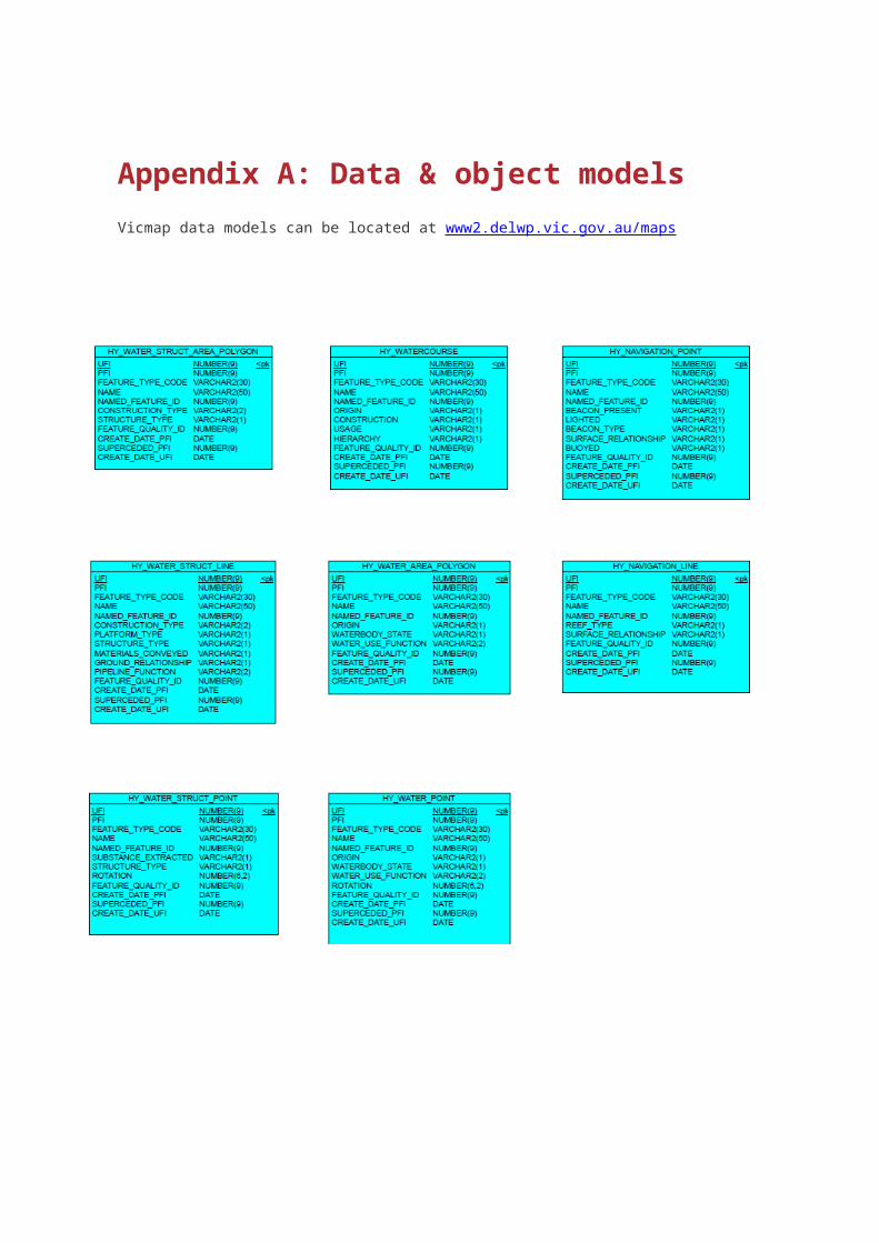
Appendix A: Data & object modelsVicmap data models can be located at www2.delwp.vic.gov.au/maps
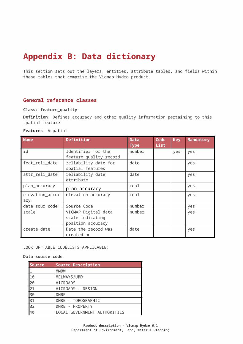
Appendix B: Data dictionaryThis section sets out the layers, entities, attribute tables, and fields within these tables that comprise the Vicmap Hydro product.
General reference classes
Class: feature_qualityDefinition: Defines accuracy and other quality information pertaining to this spatial feature
Features: Aspatial
Name Definition Data Type Code List
Key Mandatory
id Identifier for the feature quality record
number yes yes
feat_reli_date reliability date for spatial features
date yes
attr_reli_date reliability date attribute date yesplan_accuracy plan accuracy real yes
elevation_accuracy elevation accuracy real yesdata_sour_code Source Code number yesscale VICMAP Digital data scale
indicating position accuracynumber yes
create_date Date the record was created on date yes
LOOK UP TABLE CODELISTS APPLICABLE:
Data source code
Source Source Description1 MMBW10 MELWAYS/UBD20 VICROADS21 VICROADS - DESIGN30 DNRE31 DNRE - TOPOGRAPHIC32 DNRE - PROPERTY40 LOCAL GOVERNMENT AUTHORITIES50 EMERGENCY SERVICES/BEST60 WATER AUTHORITIES70 FIELD DATA CAPTURE80 SATELLITE IMAGERY81 AERIAL PHOTOGRAPHY90 NSW – LAND INFORMATION CENTRE999 UNKNOWN
Product description – Vicmap Hydro 6.1Department of Environment, Land, Water & Planning
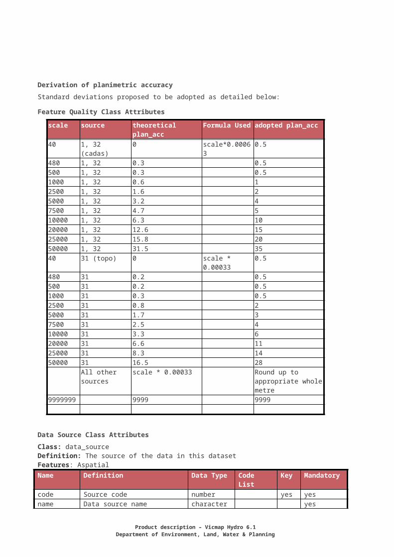
Derivation of planimetric accuracyStandard deviations proposed to be adopted as detailed below:
Feature Quality Class Attributes
scale source theoretical plan_acc Formula Used adopted plan_acc40 1, 32 (cadas) 0 scale*0.00063 0.5480 1, 32 0.3 0.5500 1, 32 0.3 0.51000 1, 32 0.6 12500 1, 32 1.6 25000 1, 32 3.2 47500 1, 32 4.7 510000 1, 32 6.3 1020000 1, 32 12.6 1525000 1, 32 15.8 2050000 1, 32 31.5 3540 31 (topo) 0 scale * 0.00033 0.5480 31 0.2 0.5500 31 0.2 0.51000 31 0.3 0.52500 31 0.8 25000 31 1.7 37500 31 2.5 410000 31 3.3 620000 31 6.6 1125000 31 8.3 1450000 31 16.5 28
All other sources scale * 0.00033 Round up to appropriate whole metre
9999999 9999 9999
Data Source Class AttributesClass: data_sourceDefinition: The source of the data in this datasetFeatures: AspatialName Definition Data Type Code List Key Mandatorycode Source code number yes yesname Data source name character yesdescription Source description character no
Data Layer Class Attributes
Class: LayerDefinition: The layer to which the features belong Features: Aspatial
18
Name Definition Data Type Code List Key MandatoryCode Layer code number yes yesName Layer name character yesDescription Layer description character notheme_code Theme code character yes
Data Theme Class Attributes
Class: ThemeDefinition: The Theme to which the features belongFeatures: AspatialName Definition Data Type Code List Key MandatoryCode Theme code number yes yesName Theme name character yesDescription Theme description character no
Named Feature Class Attributes
Class: named_featureDefinition: The list of all names of features used within Victoria, with linkages to the official Place Names Register maintained by Land Victoria.Features: Aspatial
Name Definition Data Type Code List Key MandatoryId Unique name id within Vicmap
Digital (Roads & Topographic)number yes yes
Name Name character yesPlace_name_pid Foreign key to Victorian Place
Names Registernumber yes
create_date Date the record was created on date yes
Alternate Name Class AttributeClass: alternate_nameDefinition: The list of alternative names applicable to features. Names may or may not occur in the Place Names Register.Features: Aspatial
Name Definition Data Type Code List Key Mandatoryid Unique name id for features with
a unique combination of primary and alternate names
number yes yes
name Name character yescreate_date Date the record was created on date yes
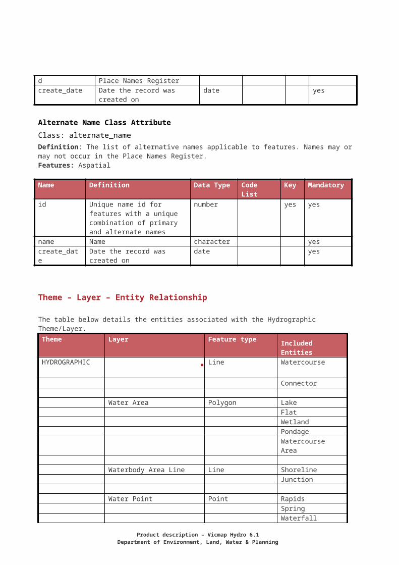
Theme – Layer – Entity Relationship
The table below details the entities associated with the Hydrographic Theme/Layer.
Product description – Vicmap Hydro 6.1Department of Environment, Land, Water & Planning
Theme Layer Feature type Included EntitiesHYDROGRAPHIC Line Watercourse
Connector
Water Area Polygon LakeFlatWetlandPondageWatercourse Area
Waterbody Area Line Line ShorelineJunction
Water Point Point RapidsSpringWaterfallWaterbody point
Navigation Point Point BuoyBeaconRockWreck
Navigation Line Line Reef LedgeWater Structure Line Line Wharf
BreakwaterLaunching RampDam wallDam wall roadCausewayLockPipeline
Water Structure Area Polygon Dam Batter
SpillwayMarina
Water Structure Point Point WellTank
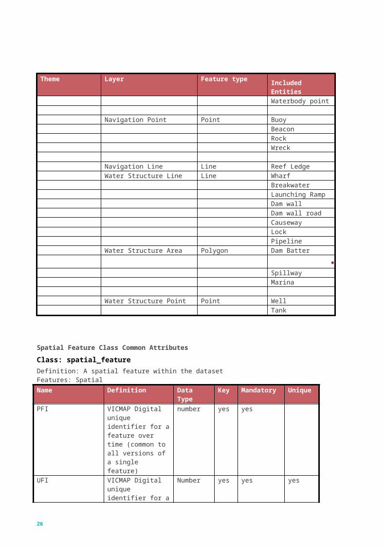
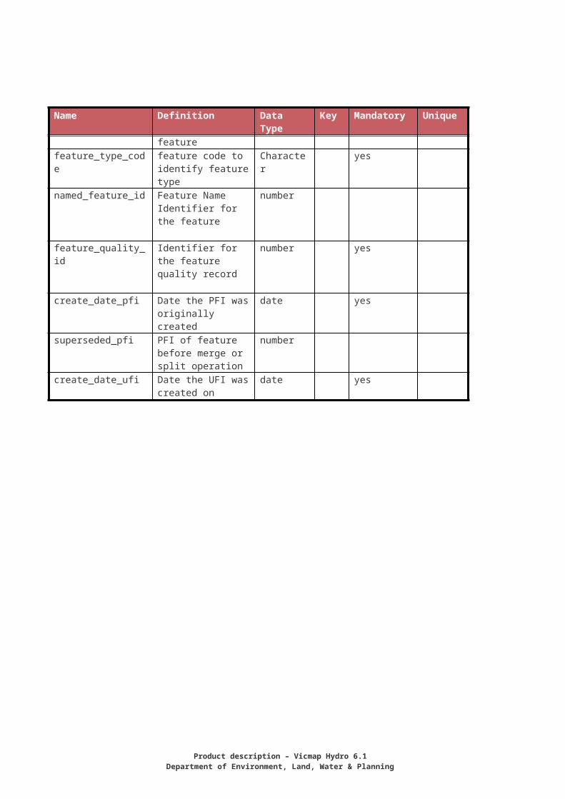
Spatial Feature Class Common Attributes
Class: spatial_featureDefinition: A spatial feature within the datasetFeatures: SpatialName Definition Data Type Key Mandatory UniquePFI VICMAP Digital
unique identifier for a number yes yes
20
Name Definition Data Type Key Mandatory Uniquefeature over time (common to all versions of a single feature)
UFI VICMAP Digital unique identifier for a feature
Number yes yes yes
feature_type_code feature code to identify feature type
Character yes
named_feature_id Feature Name Identifier for the feature
number
feature_quality_id Identifier for the feature quality record
number yes
create_date_pfi Date the PFI was originally created
date yes
superseded_pfi PFI of feature before merge or split operation
number
create_date_ufi Date the UFI was created on
date yes
Product description – Vicmap Hydro 6.1Department of Environment, Land, Water & Planning

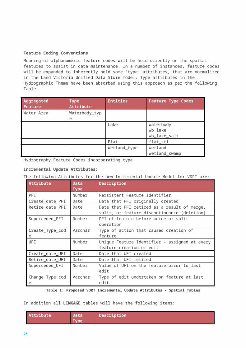
Feature Coding ConventionsMeaningful alphanumeric feature codes will be held directly on the spatial features to assist in data maintenance. In a number of instances, feature codes will be expanded to inherently hold some ‘type’ attributes, that are normalized in the Land Victoria Unified Data Store model. Type attributes in the Hydrographic Theme have been absorbed using this approach as per the following Table.
Aggregated Feature Type Attribute Entities Feature Type CodesWater Area Waterbody_type
Lake waterbodywb_lakewb_lake_salt
Flat flat_stiWetland_type wetland
wetland_swampHydrography Feature Codes incorporating type
Incremental Update Attributes:The following Attributes for the new Incremental Update Model for VDRT are:
Attribute Data Type DescriptionPFI Number Persistent Feature IdentifierCreate_date_PFI Date Date that PFI originally createdRetire_date_PFI Date Date that PFI retired as a result of merge, split, or feature
discontinuance (deletion)Superceded_PFI Number PFI of feature before merge or split operationCreate_Type_code Varchar Type of action that caused creation of featureUFI Number Unique Feature Identifier – assigned at every feature creation
or editCreate_date_UFI Date Date that UFI createdRetire_date_UFI Date Date that UFI retiredSuperceded_UFI Number Value of UFI on the feature prior to last editChange_Type_code Varchar Type of edit undertaken on feature at last edit
Table 1: Proposed VDRT Incremental Update Attributes – Spatial Tables
In addition all LINKAGE tables will have the following items:
Attribute Data Type DescriptionUFI Number Unique Feature Identifier – assigned at every feature creation
or editCreate_date_UFI Date Date that UFI createdRetire_date_UFI Date Date that UFI retired
22
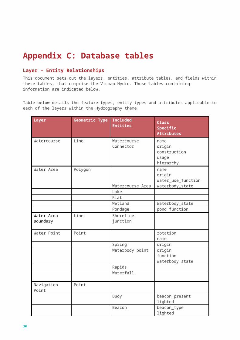
Appendix C: Database tablesLayer – Entity RelationshipsThis document sets out the layers, entities, attribute tables, and fields within these tables, that comprise the Vicmap Hydro. Those tables containing information are indicated below.
Table below details the feature types, entity types and attributes applicable to each of the layers within the Hydrography theme.
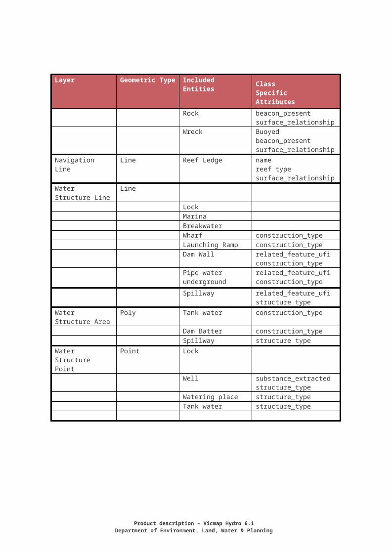
Layer Geometric Type Included Entities Class Specific Attributes
Watercourse Line WatercourseConnector
nameoriginconstructionusagehierarchy
Water Area Polygon
Watercourse Area
nameoriginwater_use_functionwaterbody_state
LakeFlatWetland Waterbody_statePondage pond function
Water Area Boundary
Line Shorelinejunction
Water Point Point rotationname
Spring originWaterbody point origin
functionwaterbody state
RapidsWaterfall
Navigation Point PointBuoy beacon_present
lightedBeacon beacon_type
lightedRock beacon_present
surface_relationshipWreck Buoyed
beacon_presentsurface_relationship
Navigation Line Line Reef Ledge namereef typesurface_relationship
Product description – Vicmap Hydro 6.1Department of Environment, Land, Water & Planning
Layer Geometric Type Included Entities Class Specific Attributes
Water Structure Line
Line
LockMarinaBreakwaterWharf construction_typeLaunching Ramp construction_typeDam Wall related_feature_ufi
construction_typePipe water underground
related_feature_uficonstruction_type
Spillway related_feature_ufistructure type
Water Structure Area
Poly Tank water construction_type
Dam Batter construction_typeSpillway structure type
Water Structure Point
Point Lock
Well substance_extractedstructure_type
Watering place structure_typeTank water structure_type
24
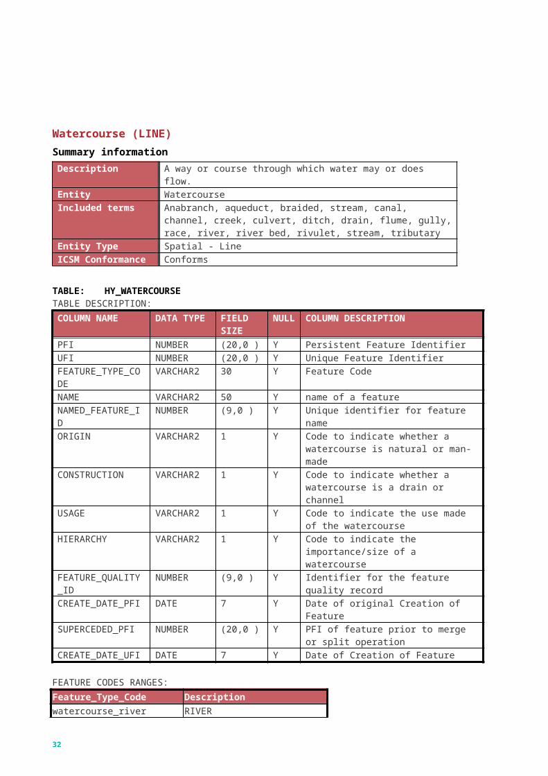
Watercourse (LINE)Summary information Description A way or course through which water may or does flow.Entity WatercourseIncluded terms Anabranch, aqueduct, braided, stream, canal, channel, creek, culvert,
ditch, drain, flume, gully, race, river, river bed, rivulet, stream, tributaryEntity Type Spatial - LineICSM Conformance Conforms
TABLE: HY_WATERCOURSETABLE DESCRIPTION:COLUMN NAME DATA TYPE FIELD
SIZENULL
COLUMN DESCRIPTION
PFI NUMBER (20,0 ) Y Persistent Feature IdentifierUFI NUMBER (20,0 ) Y Unique Feature IdentifierFEATURE_TYPE_CODE
VARCHAR2 30 Y Feature Code
NAME VARCHAR2 50 Y name of a featureNAMED_FEATURE_ID
NUMBER (9,0 ) Y Unique identifier for feature name
ORIGIN VARCHAR2 1 Y Code to indicate whether a watercourse is natural or man-made
CONSTRUCTION VARCHAR2 1 Y Code to indicate whether a watercourse is a drain or channel
USAGE VARCHAR2 1 Y Code to indicate the use made of the watercourse
HIERARCHY VARCHAR2 1 Y Code to indicate the importance/size of a watercourse
FEATURE_QUALITY_ID
NUMBER (9,0 ) Y Identifier for the feature quality record
CREATE_DATE_PFI DATE 7 Y Date of original Creation of FeatureSUPERCEDED_PFI NUMBER (20,0 ) Y PFI of feature prior to merge or split
operationCREATE_DATE_UFI DATE 7 Y Date of Creation of Feature
FEATURE CODES RANGES:Feature_Type_Code Descriptionwatercourse_river RIVERwatercourse_stream STREAMwatercourse_channel CHANNEL/AQUEDUCT (Major)watercourse_channel_drain DRAIN/CHANNELwatercourse_drain DRAINconnector_river Connector through natural water
(river) areasconnector_stream Connector through natural water
(stream) areasconnector_channel Connector through man-made
double-sided channelsconnector_drain Connector through man-made
Product description – Vicmap Hydro 6.1Department of Environment, Land, Water & Planning
double-sided drainsconnector_structure Connector through water
structures (pipes & spillways)
26
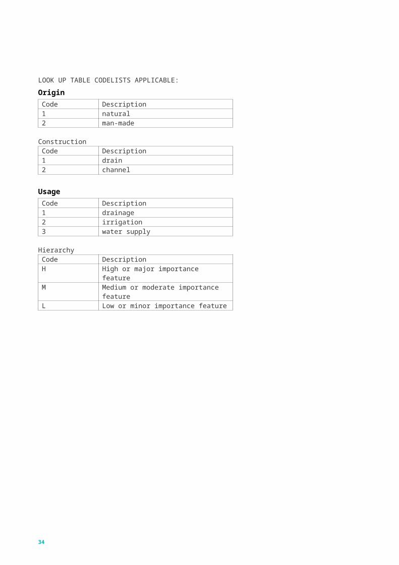
LOOK UP TABLE CODELISTS APPLICABLE:
OriginCode Description1 natural2 man-made
ConstructionCode Description1 drain2 channel
UsageCode Description1 drainage2 irrigation3 water supply
HierarchyCode DescriptionH High or major importance featureM Medium or moderate importance featureL Low or minor importance feature
Product description – Vicmap Hydro 6.1Department of Environment, Land, Water & Planning
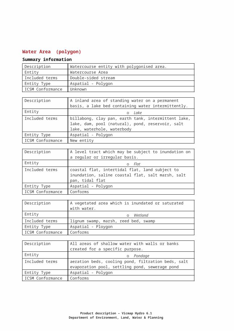
Water Area (polygon)Summary information Description Watercourse entity with polygonised area.Entity Watercourse AreaIncluded terms Double-sided streamEntity Type Aspatial - PolygonICSM Conformance Unknown
Description A inland area of standing water on a permanent basis, a lake bed containing water intermittently.
Entity o LakeIncluded terms billabong, clay pan, earth tank, intermittent lake, lake, dam, pool
(natural), pond, reservoir, salt lake, waterhole, waterbodyEntity Type Aspatial - PolygonICSM Conformance New entity
Description A level tract which may be subject to inundation on a regular or irregular basis.
Entity o FlatIncluded terms coastal flat, intertidal flat, land subject to inundation, saline coastal
flat, salt marsh, salt pan, tidal flatEntity Type Aspatial - PolygonICSM Conformance Conforms
Description A vegetated area which is inundated or saturated with water.Entity o WetlandIncluded terms lignum swamp, marsh, reed bed, swampEntity Type Aspatial - PloygonICSM Conformance Conforms
Description All areas of shallow water with walls or banks created for a specific purpose.
Entity o PondageIncluded terms aeration beds, cooling pond, filtration beds, salt evaporation pool,
settling pond, sewerage pondEntity Type Aspatial - PolygonICSM Conformance Conforms
28
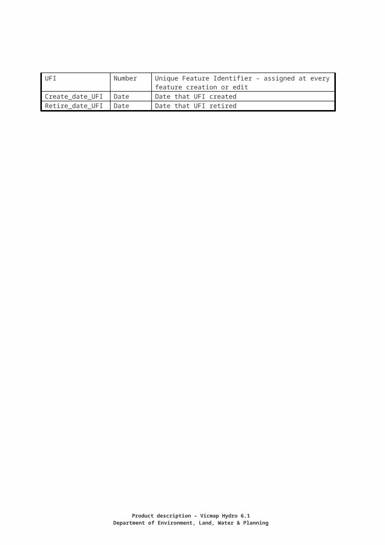
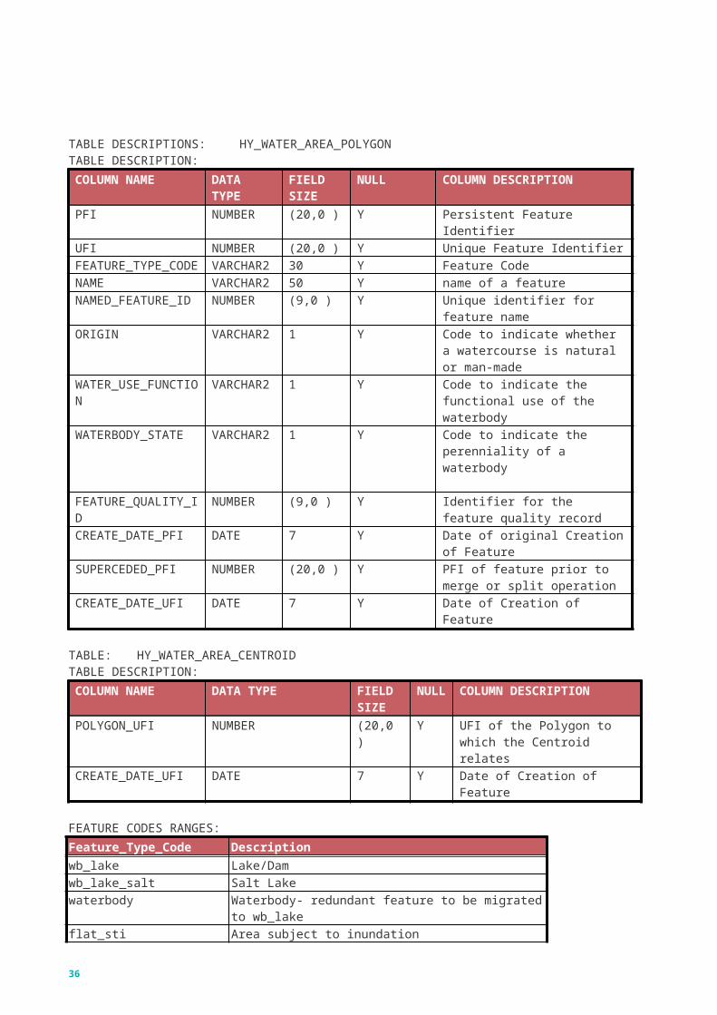
TABLE DESCRIPTIONS:HY_WATER_AREA_POLYGONTABLE DESCRIPTION:COLUMN NAME DATA
TYPEFIELD SIZE
NULL COLUMN DESCRIPTION
PFI NUMBER (20,0 ) Y Persistent Feature IdentifierUFI NUMBER (20,0 ) Y Unique Feature IdentifierFEATURE_TYPE_CODE
VARCHAR2
30 Y Feature Code
NAME VARCHAR2
50 Y name of a feature
NAMED_FEATURE_ID
NUMBER (9,0 ) Y Unique identifier for feature name
ORIGIN VARCHAR2
1 Y Code to indicate whether a watercourse is natural or man-made
WATER_USE_FUNCTION
VARCHAR2
1 Y Code to indicate the functional use of the waterbody
WATERBODY_STATE VARCHAR2
1 Y Code to indicate the perenniality of a waterbody
FEATURE_QUALITY_ID
NUMBER (9,0 ) Y Identifier for the feature quality record
CREATE_DATE_PFI DATE 7 Y Date of original Creation of Feature
SUPERCEDED_PFI NUMBER (20,0 ) Y PFI of feature prior to merge or split operation
CREATE_DATE_UFI DATE 7 Y Date of Creation of Feature
TABLE: HY_WATER_AREA_CENTROIDTABLE DESCRIPTION:COLUMN NAME DATA TYPE FIELD
SIZENULL
COLUMN DESCRIPTION
POLYGON_UFI NUMBER (20,0 ) Y UFI of the Polygon to which the Centroid relates
CREATE_DATE_UFI DATE 7 Y Date of Creation of Feature
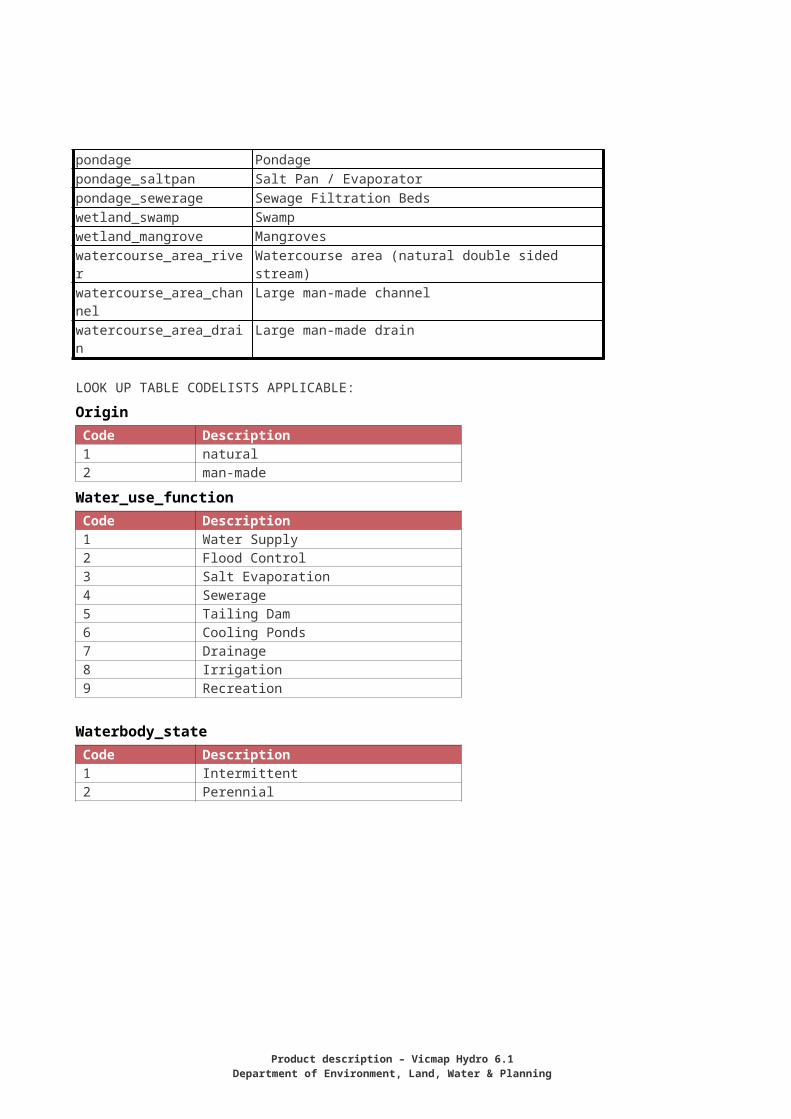
FEATURE CODES RANGES:Feature_Type_Code Descriptionwb_lake Lake/Damwb_lake_salt Salt Lakewaterbody Waterbody- redundant feature to be migrated to wb_lakeflat_sti Area subject to inundationpondage Pondagepondage_saltpan Salt Pan / Evaporatorpondage_sewerage Sewage Filtration Bedswetland_swamp Swampwetland_mangrove Mangroveswatercourse_area_river Watercourse area (natural double sided stream)watercourse_area_channel Large man-made channelwatercourse_area_drain Large man-made drain
LOOK UP TABLE CODELISTS APPLICABLE:
Product description – Vicmap Hydro 6.1Department of Environment, Land, Water & Planning
OriginCode Description1 natural2 man-made
Water_use_function Code Description1 Water Supply2 Flood Control3 Salt Evaporation4 Sewerage5 Tailing Dam6 Cooling Ponds7 Drainage8 Irrigation9 Recreation
Waterbody_state Code Description1 Intermittent2 Perennial
30
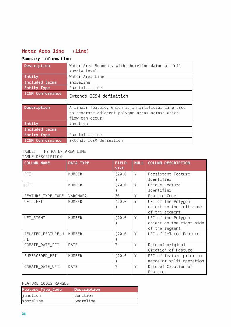
Water Area line (line)Summary informationDescription Water Area Boundary with shoreline datum at full supply level.Entity Water Area LineIncluded terms shorelineEntity Type Spatial - LineICSM Conformance Extends ICSM definition
Description A linear feature, which is an artificial line used to separate adjacent polygon areas across which flow can occur.
Entity JunctionIncluded termsEntity Type Spatial - LineICSM Conformance Extends ICSM definition
TABLE: HY_WATER_AREA_LINETABLE DESCRIPTION:COLUMN NAME DATA TYPE FIELD
SIZENULL
COLUMN DESCRIPTION
PFI NUMBER (20,0 ) Y Persistent Feature IdentifierUFI NUMBER (20,0 ) Y Unique Feature IdentifierFEATURE_TYPE_CODE
VARCHAR2 30 Y Feature Code
UFI_LEFT NUMBER (20,0 ) Y UFI of the Polygon object on the left side of the segment
UFI_RIGHT NUMBER (20,0 ) Y UFI of the Polygon object on the right side of the segment
RELATED_FEATURE_UFI
NUMBER (20,0 ) Y UFI of Related Feature
CREATE_DATE_PFI DATE 7 Y Date of original Creation of Feature
SUPERCEDED_PFI NUMBER (20,0 ) Y PFI of feature prior to merge or split operation
CREATE_DATE_UFI DATE 7 Y Date of Creation of Feature
FEATURE CODES RANGES:Feature_Type_Code Descriptionjunction Junctionshoreline Shoreline
Product description – Vicmap Hydro 6.1Department of Environment, Land, Water & Planning
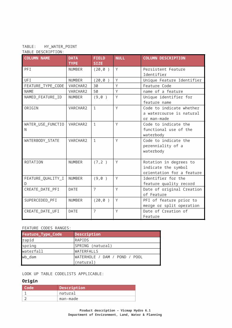
Water Point (point)Summary information Description Lake entity with point representation.Entity Waterbody PointIncluded terms Farm dam, pool (natural), pondEntity Type Spatial - PointICSM Conformance Unknown
Description The place where water issues from the ground naturally.Entity SpringIncluded terms hot spring, mineral spring, seep, soakEntity Type Spatial - PointICSM Conformance Conforms
Description An area of broken, fast flowing water in a stream, where the slope of the bed increases (but without a prominent break of slope which might result in a cascade or waterfall), or where a gently dipping bar of harder rock outcrops.
Entity RapidsIncluded terms cascadeEntity Type Spatial - PointICSM Conformance Conforms
Description The sudden descent of water over a step or ledge in the bed of a river.
Entity WaterfallIncluded terms falls , cataractEntity Type Spatial - PointICSM Conformance Unknown
32
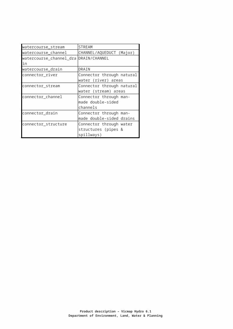
TABLE: HY_WATER_POINTTABLE DESCRIPTION:COLUMN NAME DATA
TYPEFIELD SIZE
NULL COLUMN DESCRIPTION
PFI NUMBER (20,0 ) Y Persistent Feature IdentifierUFI NUMBER (20,0 ) Y Unique Feature IdentifierFEATURE_TYPE_CODE
VARCHAR2
30 Y Feature Code
NAME VARCHAR2
50 Y name of a feature
NAMED_FEATURE_ID
NUMBER (9,0 ) Y Unique identifier for feature name
ORIGIN VARCHAR2
1 Y Code to indicate whether a watercourse is natural or man-made
WATER_USE_FUNCTION
VARCHAR2
1 Y Code to indicate the functional use of the waterbody
WATERBODY_STATE VARCHAR2
1 Y Code to indicate the perenniality of a waterbody
ROTATION NUMBER (7,2 ) Y Rotation in degrees to indicate the symbol orientation for a feature
FEATURE_QUALITY_ID
NUMBER (9,0 ) Y Identifier for the feature quality record
CREATE_DATE_PFI DATE 7 Y Date of original Creation of Feature
SUPERCEDED_PFI NUMBER (20,0 ) Y PFI of feature prior to merge or split operation
CREATE_DATE_UFI DATE 7 Y Date of Creation of Feature
FEATURE CODES RANGES:Feature_Type_Code Descriptionrapid RAPIDSspring SPRING (natural)waterfall WATERFALLSwb_dam WATERHOLE / DAM / POND / POOL (natural)
LOOK UP TABLE CODELISTS APPLICABLE:
OriginCode Description1 natural2 man-made
Water_Use_Function Code Description1 Water Supply2 Flood Control3 Salt Evaporation4 Sewerage5 Tailing Dam
Product description – Vicmap Hydro 6.1Department of Environment, Land, Water & Planning
6 Cooling Ponds7 Drainage8 Irrigation9 Recreation
Waterbody_state Code Description1 Intermittent2 Perennial
Navigation Line (line)Summary informationDescription A ridge or shelf, usually of rock or coral, lying near the surface of the
sea, which may be visible at low tide but is usually covered or awash at high tide
Entity Reef LedgeIncluded terms ledge, reef, rock ledge, shore platform, shore reef, submerged reef,
wave-cut platformEntity Type Spatial - LineICSM Conformance New entity
TABLE: HY_NAVIGATION_LINETABLE DESCRIPTION:COLUMN NAME DATA
TYPEFIELD SIZE
NULL
COLUMN DESCRIPTION
PFI NUMBER (20,0 ) Y Persistent Feature IdentifierUFI NUMBER (20,0 ) Y Unique Feature IdentifierFEATURE_TYPE_CODE
VARCHAR2
30 Y Feature Code
NAME VARCHAR2
50 Y name of a feature
NAMED_FEATURE_ID NUMBER (9,0 ) Y Unique identifier for feature nameREEF_TYPE VARCHA
R21 Y Code for Type of Reef
SURFACE_RELATIONSHIP
VARCHAR2
1 Y Code to indicate surface relationship of navigation hazard
FEATURE_QUALITY_ID
NUMBER (9,0 ) Y Identifier for the feature quality record
CREATE_DATE_PFI DATE 7 Y Date of original Creation of FeatureSUPERCEDED_PFI NUMBER (20,0 ) Y PFI of feature prior to merge or split
operationCREATE_DATE_UFI DATE 7 Y Date of Creation of Feature
FEATURE CODES RANGES:
Feature_Type_Code Descriptionreef Reef/ledgeLOOK UP TABLE CODELISTS APPLICABLE:
Reef_typeCode Description
34
1 Offshore Reef2 Shore Platform
Surface_relationship Code Description1 Submerged at low tide2 Exposed at low tide
Navigation Point (POINT)Summary informationDescription A fixed signal, mark or light and associated facilities erected for the
guidance of mariners or airplane pilotsEntity BeaconIncluded terms Aeronautical beacon, Approach lights, Channel light, Channel
marker, Leading light, Lighthouse, Navigation light, Pile beacon, VOR beacon (N)
Entity Type Spatial- PointICSM Conformance Conforms
Description A float moored or anchored in waterEntity BuoyIncluded terms Anchorage, buoy, bell buoy, cable buoy, channel buoy, dredging
buoy, fairway buoy, fishnet buoy, mooring buoy, spoil ground buoy, wreck buoy
Entity Type Spatial - PointICSM Conformance Conforms
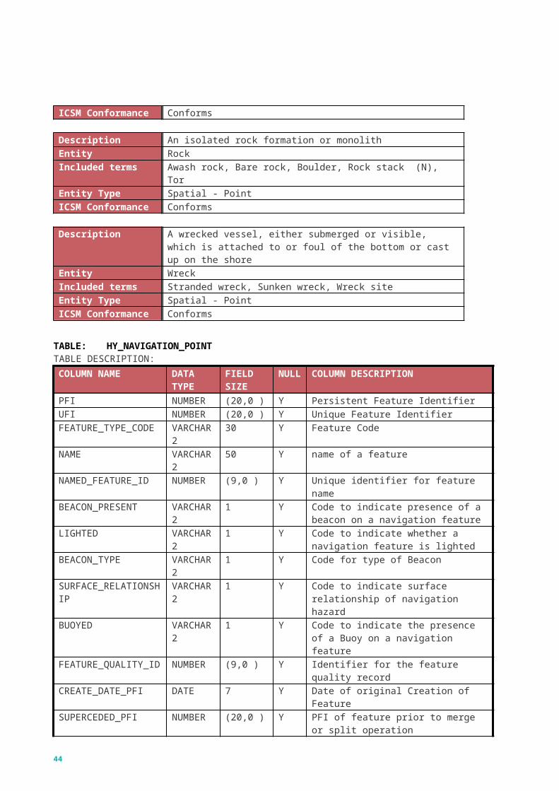
Description An isolated rock formation or monolithEntity RockIncluded terms Awash rock, Bare rock, Boulder, Rock stack (N), TorEntity Type Spatial - PointICSM Conformance Conforms
Description A wrecked vessel, either submerged or visible, which is attached to or foul of the bottom or cast up on the shore
Entity WreckIncluded terms Stranded wreck, Sunken wreck, Wreck siteEntity Type Spatial - PointICSM Conformance Conforms
TABLE: HY_NAVIGATION_POINTTABLE DESCRIPTION:COLUMN NAME DATA
TYPEFIELD SIZE
NULL
COLUMN DESCRIPTION
PFI NUMBER (20,0 ) Y Persistent Feature IdentifierUFI NUMBER (20,0 ) Y Unique Feature IdentifierFEATURE_TYPE_CODE
VARCHAR2
30 Y Feature Code
NAME VARCHA 50 Y name of a feature
Product description – Vicmap Hydro 6.1Department of Environment, Land, Water & Planning
COLUMN NAME DATA TYPE
FIELD SIZE
NULL
COLUMN DESCRIPTION
R2NAMED_FEATURE_ID NUMBER (9,0 ) Y Unique identifier for feature nameBEACON_PRESENT VARCHA
R21 Y Code to indicate presence of a beacon on
a navigation featureLIGHTED VARCHA
R21 Y Code to indicate whether a navigation
feature is lightedBEACON_TYPE VARCHA
R21 Y Code for type of Beacon
SURFACE_RELATIONSHIP
VARCHAR2
1 Y Code to indicate surface relationship of navigation hazard
BUOYED VARCHAR2
1 Y Code to indicate the presence of a Buoy on a navigation feature
FEATURE_QUALITY_ID
NUMBER (9,0 ) Y Identifier for the feature quality record
CREATE_DATE_PFI DATE 7 Y Date of original Creation of FeatureSUPERCEDED_PFI NUMBER (20,0 ) Y PFI of feature prior to merge or split
operationCREATE_DATE_UFI DATE 7 Y Date of Creation of Feature
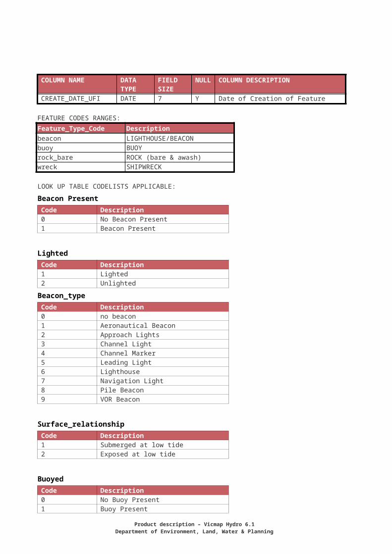
FEATURE CODES RANGES:Feature_Type_Code Descriptionbeacon LIGHTHOUSE/BEACONbuoy BUOYrock_bare ROCK (bare & awash)wreck SHIPWRECK
LOOK UP TABLE CODELISTS APPLICABLE:
Beacon PresentCode Description0 No Beacon Present1 Beacon Present
LightedCode Description1 Lighted2 Unlighted
Beacon_type Code Description0 no beacon1 Aeronautical Beacon2 Approach Lights3 Channel Light4 Channel Marker5 Leading Light6 Lighthouse7 Navigation Light
36
8 Pile Beacon9 VOR Beacon
Surface_relationship Code Description1 Submerged at low tide2 Exposed at low tide
BuoyedCode Description0 No Buoy Present1 Buoy Present
Water Structure Area (POLYGON)Summary informationDescription Dam BatterEntity Dam BatterIncluded termsEntity Type Spatial - PolygonICSM Conformance Unknown
Description A constructed path or channel for excess water to pass over or beside a dam.
Entity SpillwayIncluded terms overflow, overflow channelEntity Type Spatial - PolygonICSM Conformance Conforms
Description A structure used for the storage of fluids.Entity Tank waterIncluded terms Large elevated water tower, Large water storage tank, Large water
intake towerEntity Type Spatial - PolygonICSM Conformance Conforms
Description A harbour facility for recreational craft where supplies, repairs and various services are available
Entity MarinaIncluded termsEntity Type Spatial - PolygonICSM Conformance Conforms
Description Facility for the treatment of water for domestic, agricultural or industrial purposes
Entity Water Treatment PlantIncluded terms
Product description – Vicmap Hydro 6.1Department of Environment, Land, Water & Planning
Entity Type Spatial - PolygonICSM Conformance Conforms
TABLE: HY_WATER_STRUCT_AREA_POLYGONTABLE DESCRIPTION:COLUMN NAME DATA
TYPEFIELD SIZE
NULL
COLUMN DESCRIPTION
PFI NUMBER (20,0 ) Y Persistent Feature IdentifierUFI NUMBER (20,0 ) Y Unique Feature IdentifierFEATURE_TYPE_CODE
VARCHAR2
30 Y Feature Code
NAME VARCHAR2
50 Y name of a feature
NAMED_FEATURE_ID NUMBER (9,0 ) Y Unique identifier for feature nameCONSTRUCTION_TYPE
VARCHAR2
2 Y Code to indicate the type of dam wall construction type
STRUCTURE_TYPE VARCHAR2
1 Y Code to indicate the type of structure used for a spillway
FEATURE_QUALITY_ID
NUMBER (9,0 ) Y Identifier for the feature quality record
CREATE_DATE_PFI DATE 7 Y Date of original Creation of FeatureSUPERCEDED_PFI NUMBER (20,0 ) Y PFI of feature prior to merge or split
operationCREATE_DATE_UFI DATE 7 Y Date of Creation of Feature
TABLE: HY_WATER_STRUCTURE_AREA_CENTROIDTABLE DESCRIPTION:COLUMN NAME DATA TYPE FIELD
SIZENULL
COLUMN DESCRIPTION
POLYGON_UFI NUMBER (20,0 ) Y UFI of the Polygon to which the Centroid relates
CREATE_DATE_UFI DATE 7 Y Date of Creation of Feature
FEATURE CODES RANGES:Feature_Type_Code Descriptiondam_batter DAM BATTERdam_batter_void DAM BATTER (Void)spillway SPILLWAYmarina MARINA AREAtank_water TANK (to scale)treatment_plant WATER TREATMENT PLANT (to scale)
LOOK UP TABLE CODELISTS APPLICABLE:
Construction_type Code Description1 barrage2 gauging weir3 reservoir well4 weir
38

Structure_type Code Description1 overflow channel2 wall spillway
Water Structure Line (LINE)Summary informationDescription A structure built to break the force of waves so as to protect a beach,
harbour, or other water front facility.Entity BreakwaterIncluded terms Boom, Quay, Seawall, Training wall, GroyneEntity Type Spatial _ LineICSM Conformance Conforms
Description A barrier of earth and/or rock, concrete or masonry constructed to form a reservoir for water storage purposes or to raise the water level.
Entity Dam WallIncluded terms barrage, guaging weir, reservoir wall, weirEntity Type Spatial - LineICSM Conformance Conforms
Description A place for launching or retrieving boats from the waterEntity Launching RampIncluded terms Launching ramp, Patent slip, Ramp, SlipwayEntity Type Spatial - LineICSM Conformance Conforms
Description An enclosure in a water body with gates at both ends to raise or lower the water level to enable vessels to pass from one level to another.
Entity LockIncluded terms boat lift, entrance lock, tide lockEntity Type Spatial - LineICSM Conformance Conforms
Description Utility water pipelineEntity PipelineIncluded terms siphon, water pipeline,Entity Type Spatial - LineICSM Conformance Conforms
Description Any structure on a waterfront, designed to make it possible for vessels to lie alongside and take or unload cargo, passengers etc.
Entity WharfIncluded terms Ferry terminal, Hovercraft landing, Jetty, Landing, Landing stage,
Mole, Pens, PierEntity Type Spatial _ LineICSM Conformance Conforms
Product description – Vicmap Hydro 6.1Department of Environment, Land, Water & Planning
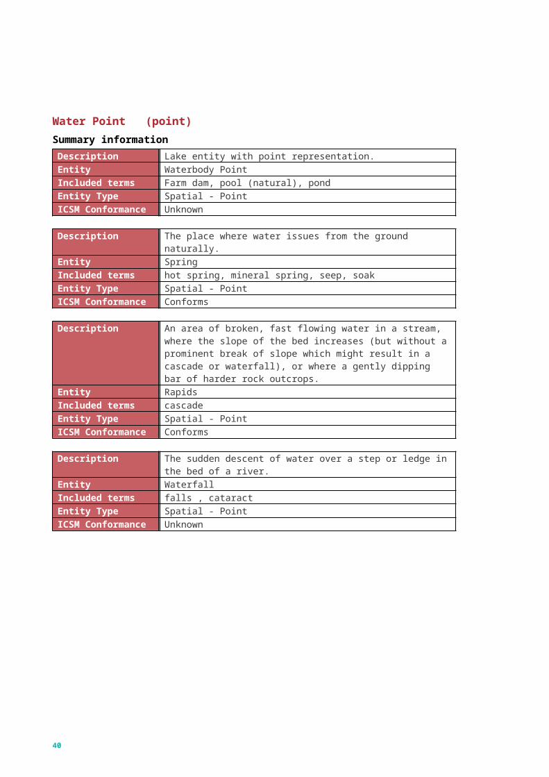
TABLE: HY_WATER_STRUCTURE_LINETABLE DESCRIPTION:COLUMN NAME DATA
TYPEFIELD SIZE
NULL
COLUMN DESCRIPTION
PFI NUMBER (20,0 ) Y Persistent Feature IdentifierUFI NUMBER (20,0 ) Y Unique Feature IdentifierFEATURE_TYPE_CODE
VARCHAR2
30 Y Feature Code
NAME VARCHAR2
50 Y name of a feature
NAMED_FEATURE_ID NUMBER (9,0 ) Y Unique identifier for feature nameCONSTRUCTION_TYPE
VARCHAR2
2 Y Code to indicate the type of dam wall or coastal structure construction type
STRUCTURE_TYPE VARCHAR2
1 Y Code to indicate the type of structure used for a spillway
PIPELINE_FUNCTION VARCHAR2
1 Y Code to indicate the function of the water pipeline
GROUND_RELATIONSHIP
VARCHAR2
1 Y Code to indicate the ground relationship of a pipeline
FEATURE_QUALITY_ID
NUMBER (9,0 ) Y Identifier for the feature quality record
CREATE_DATE_PFI DATE 7 Y Date of original Creation of FeatureSUPERCEDED_PFI NUMBER (20,0 ) Y PFI of feature prior to merge or split
operationCREATE_DATE_UFI DATE 7 Y Date of Creation of Feature
FEATURE CODES RANGES:Feature_Type_Code Descriptionbreakwater BREAKWATERcauseway CAUSEWAYdam_wall Dam walldam_wall_road DAM WALL WITH ROADlaunching_ramp Launching Ramplock LOCKwharf PIER/JETTY/WHARFpipe_water Pipeline -waterpipe_water_uground U/G PIPELINE (Water)
40
LOOK UP TABLE CODELISTS APPLICABLE:
Construction_type Code Description1 barrage2 gauging weir3 reservoir well4 Weir
Structure_type Code Description1 Overflow Channel2 Wall Spillway
Pipeline_functionCode Description1 Siphon2 Penstock
Ground_relationship Code Description1 Above Ground Surface2 Underground
Water Structure Point (POINT)Summary informationDescription A structure used for the storage of fluids.Entity Tank waterIncluded terms Elevated water tank, Water storage tank,Entity Type Spatial - PointICSM Conformance Conforms
Description A pit or hole dug or bored into the earth for the extraction of waterEntity WellIncluded terms artesian bore, bore,, native well, water wellEntity Type Spatial - PointICSM Conformance Conforms
TABLE: HY_WATER_STUCTURE_POINTTABLE DESCRIPTION:COLUMN NAME DATA
TYPEFIELD SIZE
NULL COLUMN DESCRIPTION
PFI NUMBER (20,0 ) Y Persistent Feature IdentifierUFI NUMBER (20,0 ) Y Unique Feature IdentifierFEATURE_TYPE_CODE
VARCHAR2
30 Y Feature Code
NAME VARCHAR2
50 Y name of a feature
NAMED_FEATURE_ID NUMBER (9,0 ) Y Unique identifier for feature name
Product description – Vicmap Hydro 6.1Department of Environment, Land, Water & Planning
COLUMN NAME DATA TYPE
FIELD SIZE
NULL COLUMN DESCRIPTION
STRUCTURE_TYPE VARCHAR2
1 Y Code to indicate the type of well, bore or watering place structure
PUBLIC NUMBER (1,0) Y Used for identifying water tanks (tank_water) on public land
ROTATION NUMBER (7,2 ) Y Rotation in degrees to indicate the symbol orientation for a feature
FEATURE_QUALITY_ID
NUMBER (9,0 ) Y Identifier for the feature quality record
CREATE_DATE_PFI DATE 7 Y Date of original Creation of Feature
SUPERCEDED_PFI NUMBER (20,0 ) Y PFI of feature prior to merge or split operation
CREATE_DATE_UFI DATE 7 Y Date of Creation of Feature
FEATURE CODES RANGES:Feature_Type_Code Descriptiontank_water TANK (water)watering_place WATER POINTwell_water BORE/WATER WELL
LOOK UP TABLE CODELISTS APPLICABLE:
structure_type Code Description1 artesian bore2 brick-lined well3 Dam4 Stand Pipe5 Watercourse Access
42
Appendix D: Reference tablesVicmap Hydro should be used in conjunction with Vicmap Reference Tables to fully utilise the information it contains. Relevant reference tables include:
ANZLIC ID Dataset name
beacon_type
beacon_present
buoyed
construction
construction_type
ground_relationship
hierarchy
lighted
origin
pipeline_function
reef_type
rotation
usage
structure_type
Product description – Vicmap Hydro 6.1Department of Environment, Land, Water & Planning
surface_relationship
water_use_function
waterbody_state
44
delwp.vic.gov.au Product description – Vicmap Hydro 6.1
Department of Environment, Land, Water & Planning