Embed Size (px)
Citation preview
PETROPHYSICAL MODELING OF THE TERTIARY RESERVOIRS IN THE SMALL GIANT BAI HASSAN OIL FIELD,
NORTHERN IRAQ
GASHAM ZEYNALOV1, MUHAMMED A. ISMAIL1 and FAWZI AL-BEYATI2
1 Department of Petroleum Engineering, Khazar University 41 Mehseti street, Baku AZ1096, Azerbaijan 2 Kirkuk Technical University, Baghdad street, Kirkuk 36001, Iraq
Abstract
The main purpose of this study is to build a petrophysical model of the Bai Hassan oil field to get valuable information about poroperm properties of the Tertiary reservoirs for the exploration target within this field. Petrophysical model of the field will allow to determine further direction of exploration drilling, secondary recovery, well distribution and well injection engineering for future. This work consists of two main parts, the part one is log analysis, which involves determination of Archie petrophysical parameters as porosity, water saturation, irreducible water saturation and permeability. The second part includes building petrophysical model for Bai Hassan oil field, based on the Petrel software to simulate the 3D model which indicates that northwest-southeast part of the Bai Hassan field has good quality reservoir in the Jeribe formation of the Tertiary.Key Words: petrophysical modelling, porosity, permeability, Jeribe formation, Bai Hassan field, Northern Iraq
IntroductionThe recovery efficiency of reservoir is influenced by its heterogeneities, particularity the distributions of porosity and permeability. Therefore, in order to develop a representative model of the reservoir, should be evaluated porosity, permeability properties and production potential of fields.
The main aim of the research is to study the application of reservoir characterization and wireline log analyses to build a new petrophysical model for the Jeribe formation in Bai Hassan oilfield in Northern Iraq.
A principal objective for building models at Bai Hassan oil field is to integrate the geological, geophysical and reservoir data collected over several decades in order to visualize and evaluate the interactions between these data using full-field reservoir simulation. Application of the petrophysical study and log analysis on Petrel software to build up static geological model and estimate the best well positions for future
drilling depending on the high permeable zone resulted from the petrophysical modeling.
The most important phase of a reservoir study is definition of a petrophysical model of the reservoir rock, given both the large number of activities involved, and its impact on the end results. As we are known, the production capacity is depended from geometrical and petrophysical characteristics of the reservoir. The availability of a representative static model is therefore an essential condition for the subsequent dynamic modeling (Lucia Cosentino, 2001).
The hand-made models proposed by Johnson and Krol (1984) rely on geological interpretation of well log data. The well data provided locations where the channels are positioned arbitrarily in the interwell areas as sandstone is insufficiently extensive laterally to be correlated between wells (Lucia Cosentino, 2001).
Alternative methods are random object distribution of the sand bodies (Haldorsen and Lake 1984, Augedal, Stanley and More 1986, Clementsen, 1989) or sedimentological process related models (Bridge and Leeder, 1997 and Alexander, 1986). These methods made use of stochastic simulations to describe the complex geological architecture honoring the well data and conditioned to the probability distributions obtained from outcrops or other studies of analog depositional environments. This stochastic technique was first suggested by Haldorsen and Lake, 1984.
Henriquez et al., (1990) applied the method to first build a stochastic model conditioned to sand body thickness and position in wellbores and then the geological model was transferred to a reservoir simulation grid by use of transmissibility multipliers and an NGR (net/gross ratio) value for each block. The authors reported that the transfer of data smoothies out much of the detailed geological information and the calculated recovery factors are insensitive to the continuity measured in the geological model and therefore they proposed an improvement to the interface between geological and reservoir simulation model (Vinh Phan, 2002).
Smith and Morgan (1986) developed conceptual and stochastic models for both faulted reservoir sands and fluvial sands. These models enabled the calculations of the permeability reduction across fault sections and the recovery factors in fluvial reservoirs that can be used in a conventional numerical simulator (Vinh Phan, 2002).
There are a number of recently developed techniques for characterizing inter well heterogeneities that were reported to be efficient and useful to study the sensitivity of production performance to the uncertainty in geological modeling.
Begg, Gaustason and Deacon (1992) and Begg, Kay, Gustason, and Angert (1996) developed a new, quantitative, object based model of the distribution of lithotypes
within each major facies and converted these models to spatial distributions of porosity/permeability and then upscale these for use in flow simulation.
This method was based on geological structures drawn from training images to generate fluvial reservoir models constrained to seismic and well log data. The author reported that the algorithm developed can efficiently be applied to real three dimensional reservoirs with up to 107 cells (Vinh Phan, 2002).
Geological Settings
Bai Hassan oil field is located in the northern-east part of Iraq within the Foothill Region of the northwest-southeast trending Zagros Fold and Thrust Belt the field have been mapped previously as northwest-southeast trending doubly plunging anticline manifested as classic four-way structural closures (Dunnington, 1958) (Fig.1).
The field contain from 2 domes (in SE – NW direction) Kithka Dome and Dauod Dome previously separated by a narrow saddle called Shahal saddle, Kithka dome is bigger in size and higher structurally by (335m) than Dauod dome (Fig.2). The number of wells drilled to the time of the preparation this study reached 185 wells (Buday, 1980).
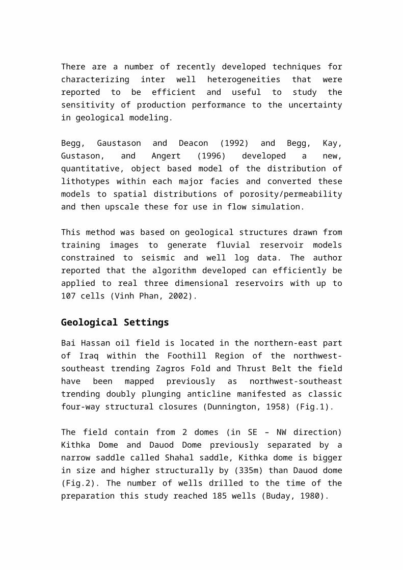
Fig.1: Oil and gas fields of the Northern Iraq.
The Jeribe reservoirs of Bai Hassan oil field occur in Tertiary (Eocene age) carbonates, while Qamchuqa reservoirs are carbonates of Albian age (Al- Shididi et al., 1995). Bai Hassan oil field has extended previous mapping to include associated fault frameworks consisting of an imbricate front thrust and back thrust fault set within each of the two structures; in addition, northeast-southwest trending tear faults are present within the Bai Hassan structure to accommodate differential fault movement on the separate and loosely coupled lateral thrust sheet segments comprising the front and back thrusts age (Bellen et al 1959).
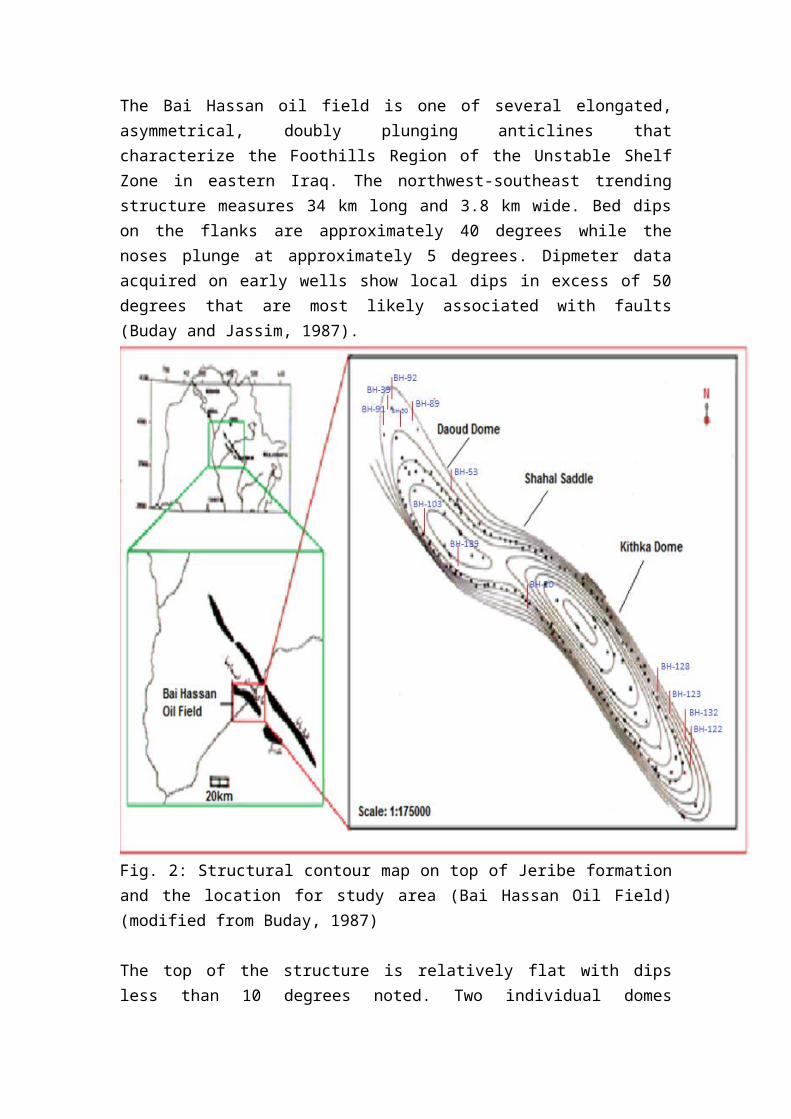
The Bai Hassan oil field is one of several elongated, asymmetrical, doubly plunging anticlines that characterize the Foothills Region of the Unstable Shelf Zone in eastern Iraq. The northwest-southeast trending structure measures 34 km long and 3.8 km wide. Bed dips on the flanks are approximately 40 degrees while the noses plunge at approximately 5 degrees. Dipmeter data acquired on early wells show local dips in excess of 50 degrees that are most likely associated with faults (Buday and Jassim, 1987).
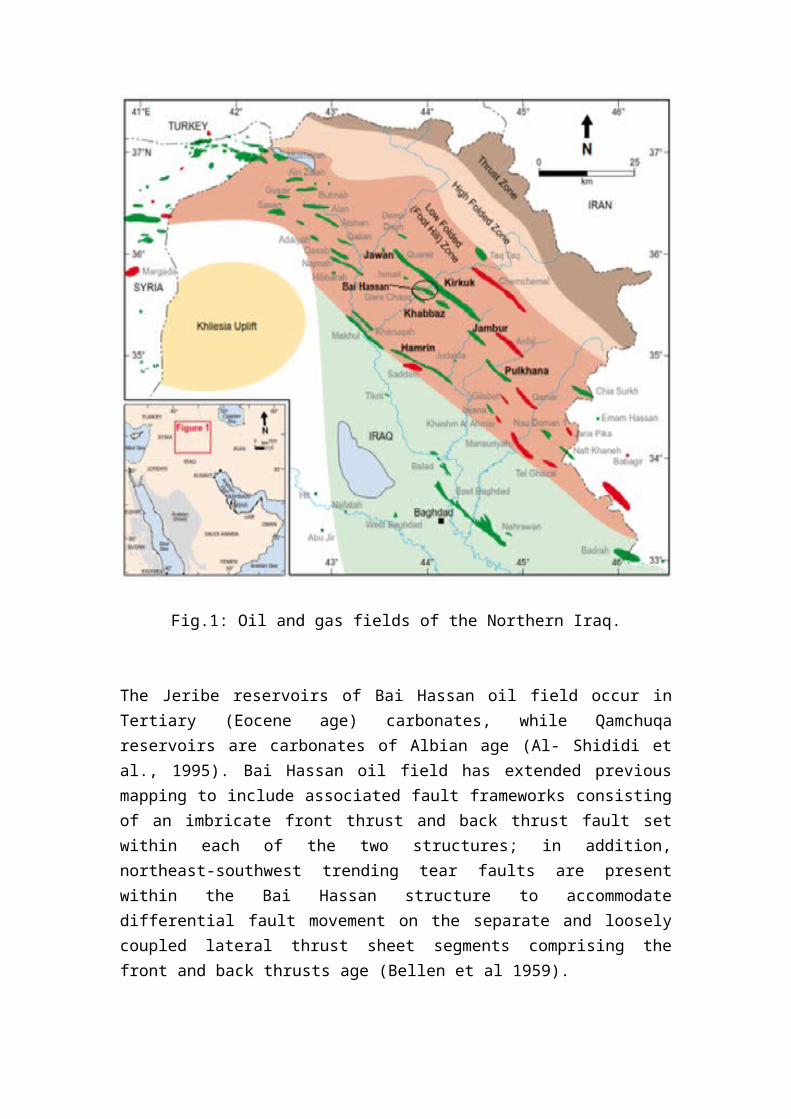
Fig. 2: Structural contour map on top of Jeribe formation and the location for study area (Bai Hassan Oil Field) (modified from Buday, 1987)
The top of the structure is relatively flat with dips less than 10 degrees noted. Two individual domes separated by a shallow saddle make up the Bai Hassan structure. Kithke Dome is the larger and more prolific of the two domes. It has a significant surface expression that is easy to see on remote sensing images. Daoud Dome does not have a surface expression, is smaller, and less prolific. Consequently, it was not discovered and produced until several years after production was established on Kithke Dome (Buday and Jassim, 1987).
The two domes are physically separated by the Shahal Saddle. It is highly likely that the Shahal Saddle is associated with a deep seated, axis-perpendicular, extension fault that was reactivated and influential in the general structural development of Bai Hassan oil field during Miocene compression and folding. It is also likely that the structure is still in compression today (Buday and Jassim, 1987).
Two distinctly different periods of tectonism are responsible for the creation of the present day structure and resulting stratigraphy. Early pre-Tertiary rifting caused by extension of the Arabian and Eurasian plates created a graben system of normal faults and basement fault blocks that were covered with a thick succession of platform carbonates. The onset of compression in the early Tertiary resulted in the closing and shallowing of the ancestral Cretaceous seaway (Buday and Jassim, 1987).
This resulted in the deposition of fore-reef and reef associated carbonates and buildups. Continued shortening during the Miocene resulted in the folding and thrusting that ultimately created the present day structures of the Zagros Fold Belt including Bai Hassan oil field. It is likely that this event caused a breach in the late Cretaceous-Early Tertiary seals, thereby allowing oil to migrate vertically into the lithifying Tertiary carbonate reservoirs. Sabkha evaporites and continental clastics finished filling what remained of the ancestral foredeep thereby sealing the hydrocarbons in the anticline. Defining fault patterns has proven difficult because of the types and vintages of data available for interpretation (Buday and Jassim, 1987).
Laboratory models and analog structures exposed to similar tectonic forces demonstrate frontal thrust faults associated with the folding episode. These faults would not extend to the surface through the ductile evaporites and, similarly, would sole out in the plastic shales of the Lower Cretaceous and Jurassic. A relief fault or back thrust fault would be expected to develop and terminate against the main front thrust faults. It, too, would not be expressed at the surface (Buday and Jassim, 1987).
The older extension faults associated with Pre-Cretaceous rifting would be obliterated
post thrusting and may be redeveloped as scissor faults, thrust faults, or strike-slip faults. The only set of faults confirmed by well data and seismic data are a set of shallow thrust faults that extend from the surface and sole out in the evaporites of theTransition Beds. These faults are not involved in reservoir development and production. Another model-based set of faults assumed to exist are crestal graben extension faults along the axis of the structure (Buday and Jassim, 1987).
These faults are indirectly supported by the problems associated with drilling crestal wells, e.g. mud loss. The Bai Hassan structure appears to be filled to spill point and contains both an oil leg and associated gas cap in the Tertiary. There is no evidence of an original gas cap in the Cretaceous. Data suggests that the two domes are in communication, therefore, the original oil-water contact is assumed to be consistent between both domes, albeit tilted (Buday and Jassim, 1987).
Bai Hassan Field produces from two distinctly different reservoir sections. The prolific Tertiary section is stratigraphically separated from the under-exploited Cretaceous section by the outer neritic and basinal deposits of the Jaddala and Aaliji formations. The ductile Jaddala and Aaliji formations can get up to 200 meters thick, thereby, presenting an effective seal to vertical fluid flow out of the Cretaceous (Bellen et al., 1959).
These formations, however, must have been breached at several times during their burial history in order to allow hydrocarbons to migrate vertically from the Jurassic and Lower Cretaceous source beds to the Tertiary reservoirs.
It appears that they have also had the ability to quickly and effectively heal themselves. The Tertiary fluids are ultimately trapped by the overlying, thick, evaporitic sections of the Transition Beds. Seismic data indicates that the Jeribe through L. Qamchuqa formations are essentially conformable.
The tightly folded structure and the conformability of these strata results in a shrinking reservoir area with depth. In other words, the L. Qamchuqa reservoir area is significantly smaller than the Bajawan reservoir area as the fold structure tightens with depth (Bellen et al., 1959).
At some depth, however, a detachment surface must exist that serves as a glide plane associated with the thrusting events that formed Bai Hassan. Structural elements (hydrocarbon traps) below this detachment (paleozoic age) surface may be very different from the typical Bai Hassan traps.
Methodology
The petrophysical modeling has resolved important issues in petroleum exploration and production, such as hydrocarbon reserve assessment, reservoirs characterization, reservoir distribution etc.
To construct 3D petrophysical model of the reservoir, using Petrel software followed a standard workflow: (i) input data, (ii) structure modeling, (iii) up scaling, (iv) data analysis, (v) facies modeling, (vi) petrophysical modeling (porosity, permeability and water saturation).
At the meantime petrophysical property modeling is the process of assigning petrophysical property values (porosity, permeability and water saturation) to each cell of the 3D grid.
Petrophysics model was built using geostatistical methods. The geostatistical algorithm (Statistical Sequential Gaussian Simulation Algorithm) represents a statistical method, which fits with the amount of available data (Faeq, 2013).
To achieve the aims of this study we need to collect data existence in relation to petrophysical characteristics and reservoir fluid saturations, the following material is:-
1) Choice ten wells cover the two saddle of the Tertiary reservoir in Bai Hassan oil field (BH-20, BH-50, BH-53, BH-39, BH-89, BH-122, BH-123, BH-91, BH-132, BH-92).
Table 1: Wells Total Depth and RTKB
Well No. TD (m) RTKB(m)BH-20 1485.6 254.2BH-122 1426 291BH-123 1406 301BH-89 1482 299
BH-132 1510 298BH-50 1505 260.06BH-53 1800 270.8
BH-39 1480 275.8BH-91 1404 254
BH-92 1412 247
2) Wireline logs of the ten well sections include, Dual Laterolog (Laterolog Deep Log LLD, Micro Spherical Focused Log μSFL), Compensated Neutron Log
(CNL), Formation Density Compensated (FDC), Sonic log and Gamma Ray (GR).
3) Using software petrel to draw 3D models to all the wells with ability to take a view with 360˚
Petrophysical Modeling
Petrel software was chosen to build petrophysical model for the Bai Hassan oil field. Petrel is a software application package for subsurface interpretation and modeling, allowing building and updating reliable subsurface models. For the purpose of this study, a data base was created within Petrel, clearly delineating the different information and data needed to complete the study. The geological, and petrophysical data were imported to Petrel within the main data base. This made it possible to generate and visualize the imported data in 2D as well as 3D.
The work flow design used for the study and wide range of functional tools in the petrel software include: 3D visualization, well correlation, 3D mapping, and 3D grid design for geology simulation, well log up scaling, petrophysical modeling, data analysis, and volume calculation.
1. Data Preparation Data preparation is the basis for geologic model. This geologic model building chiefly applies in the software. On the basis of software demand and research area characteristic, the data prepared for this 3D- geological model are well log heads, well tops, well logs (Raw data and CPI), and core analysis. Well data are imported in three steps, the first step is well head. A well head include the top position of the well path, the measured depth along the path, the well name and optionally a well symbol.
The second step is well tops, this used to marker representing significant points along the well path when there is a change in stratigraphy between reservoir units of Bai Hassan oil wells. The third step is well logs that included; gamma ray, neutron, sonic, density and resistivity as well as the CPI (porosity, permeability and water saturation). Well logs imported log values along the well path and attached to the path.
2. Porosity Model
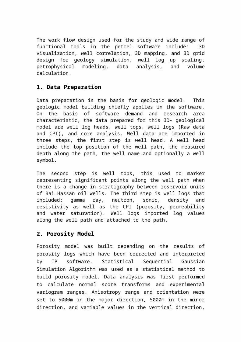
Porosity model was built depending on the results of porosity logs which have been corrected and interpreted by IP software. Statistical Sequential Gaussian Simulation Algorithm was used as a statistical method to build porosity model. Data analysis was first performed to calculate normal score transforms and experimental variogram ranges. Anisotropy range and orientation were set to 5000m in the major direction, 5000m in the minor direction, and variable values in the vertical direction, using an exponential variogram model with a variable nugget and a major direction azimuth of (-45 ͦ).
Fig. 3: Porosity distribution in the Jeribe Formation of the Bai Hassan oil field, Northern Iraq
The porosity distribution through the Jeribe formation in Bai Hassan oil field is in
figures of 3, 4,5. They show that the effective porosity has heterogeneity with random
distribution within the reservoir in NE and SW areas of the field (green zone) in area
location of BH-128, BH-132, BH-103, BH-139, BH-50 and BH-92 wells and its value
is around 14%-18%.
In the blue zone the porosity is characterized with poor quality in area of location BH-
122, BH-123, BH-20, BH-53, BH-89, BH-39, BH-91 wells. The value of porosity is
around 10%-14%.
Fig.4: Porosity correlation in wells (BH-20, BH-39, BH-50, BH-53, BH-122)
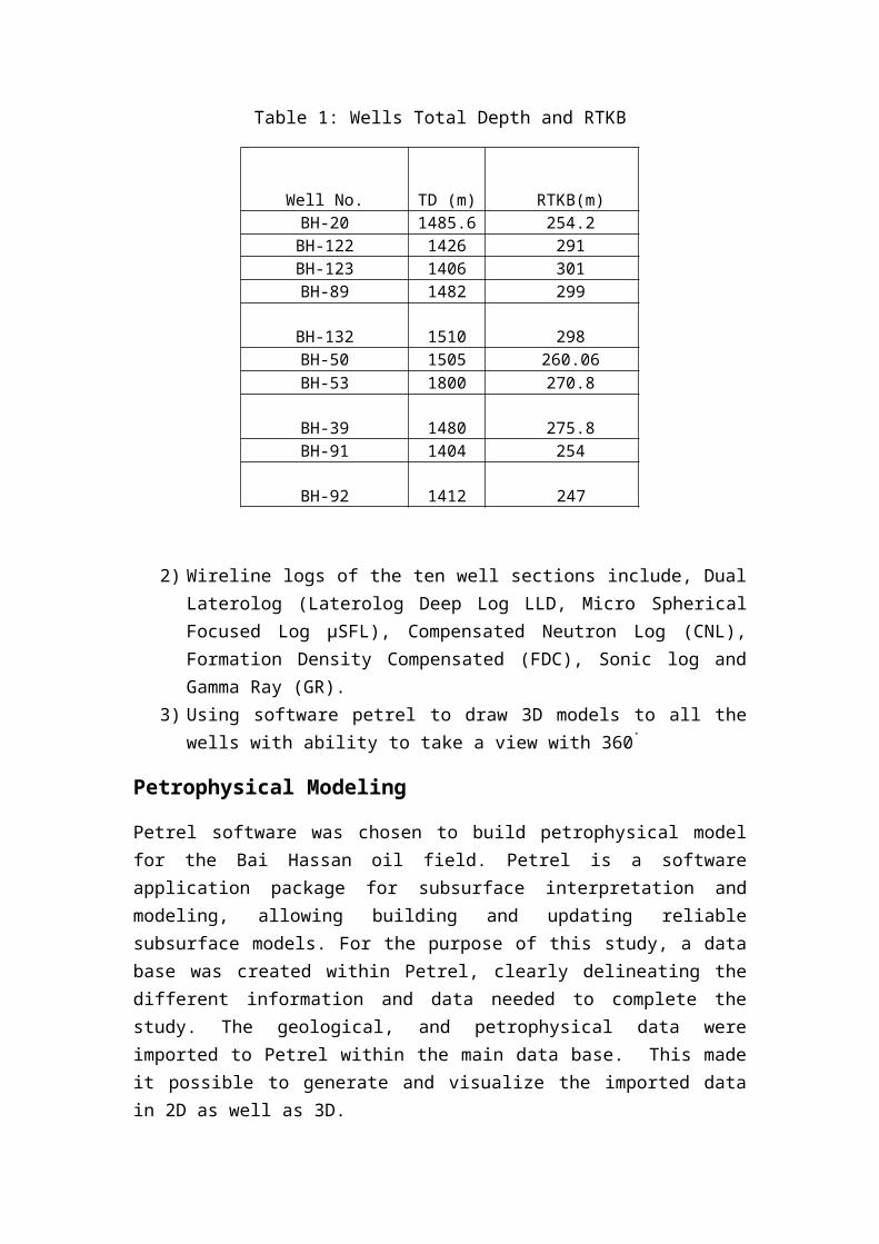
Fig.5: Porosity correlation between studied wells (BH-89, BH-91, BH-92, BH-20, BH-123, BH-132)
3 .Permeability Model
Log-derived permeability formulas are only valid for estimating permeability in formations at irreducible water saturation (Schlumberger, 1977 in Asquith and Krygowski, 2004). Before calculating the permeability, we must first determine whether or not a formation is at irreducible water saturation. Whether or not a formation is at irreducible water saturation depends upon bulk volume water values (BVW = Sw * Φ). When the bulk volume water values of a formation are constant, the zone is at irreducible water saturation.
Statistical Sequential Gaussian Simulation Algorithm was used as a statistical method to build permeability model. Data analysis was first performed to calculate normal score transforms and experimental variogram ranges. Variogram ranges were set to 5000m in the major direction, 5000m in the minor direction, and variable values in the vertical direction, using an exponential variogram model with a variable nugget and a major direction azimuth of (-45 ͦ).
The permeability distribution through Jeribe formation in Bai Hassan oil field is in
figure 6,7,8. It's clear that the permeability in general in these formation is good in
some places (green area) for example in BH-128, BH-132, BH-123, BH-89, BH-50
and BH-91 wells the permeability is represent in good area and the value is around
about (10-100md).
In the (blue area) it is clear that the permeability is not good and the wells BH-122,
BH-20, BH-53, BH-139, BH-103, BH-39 and BH-92 in this places. The value of
permeability is around between (1-10md).
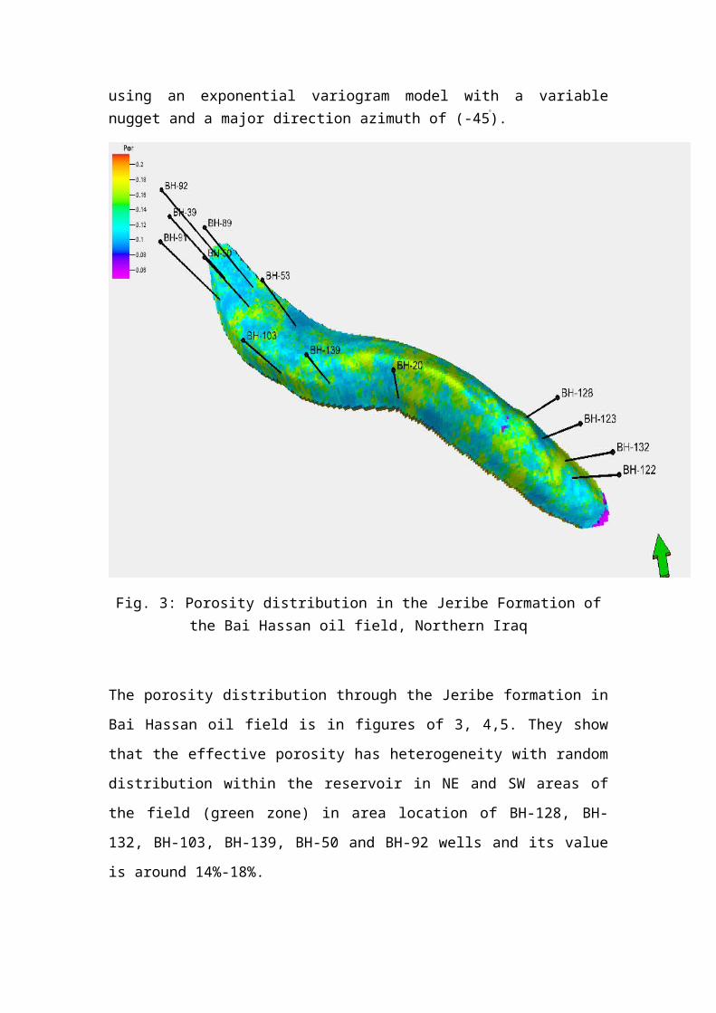
Fig. 6: Permeability distribution in the Jeribe Formation, Bai Hassan oil field

Fig.7: Permeability correlation in wells (BH-20, BH-39, BH-50, BH-53, BH-122)
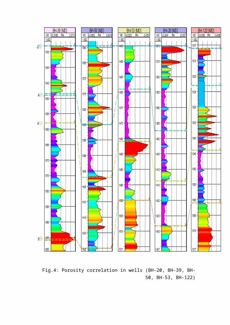
Fig.8: Permeability correlation in wells (BH-89, BH-91, BH-20, BH-92, BH-123, BH-132)
Conclusions
The distribution of the Jeribe reservoir in Bai Hassan oil field from 3D model indicated some areas having good reservoir quality in the NW, SE and some areas of central part of the field.
Calculated porosity from logs indicates that the primary porosity is the main controller porosity in the porous media, where the primary porosity in Bai Hassan oil field in 3D model is in range between 10%-18%. The high quality in the reservoir is the NW, and SE of the field.
Permeability from well log analysis and irreducible water saturation at Jeribe formation in the Bai Hassan oil field in 3D model is in range of 1-100 md. The highest values are registered in NW, and SW part of the field.
Created petrophysical model of the Tertiary reservoir in Bai Hassan field will allow to determine further direction of exploration drilling.
References
Al Shdidi, S., Thomas G. and Delfaud, J., 1995: Sedimentology, Diagenesis and Oil Habit of Lower Cretaceous Qamchuqa Group, Northern Iraq. AAPG Bulletin, V.79, No.5, pp.763-779.
Alexander, J., 1986: Idealized Flow Models to Predict Alluvial Sandstone Body Distribution in the Middle Jurassic Yorkshire Basin, Marine and Petroleum Geology No. 3, pp.298–305.
Asquith, G., and Krygowski, D., 2004: Basic Well Log Analysis, 2nd.ed, sections by Steven Henderson and Neil Hurleg, The American Association of Petroleum Geologist, Tulsa, Oklahoma, AAPG. Methods in Exploration Series No.16.
Bellen R., C., Van, Dunnington, H., V., Wetzel R. and Morton, D., 1959, Lexique Stratigraphique Internal Asie. Iraq. Intern. Geol. Conger. Comm. Stratigr, Geology of Iraq, first ed., Brno, Czech Republic, pp.128-184.
Bridge, J. S. and Leeder, M. R., 1997: A Simulation Model of Alluvial Stratigraphy., Sedimentology No. 26, pp.617–44.
Buday, T., 1980: The Regional Geology of Iraq, Volume I; Stratigraphy and Paleogeography. Dar AL-Kutib publishing house, University of Mosul. Iraq. pp. 445.
Buday, T. and Jassim, S. Z., 1987: The Regional Geology of Iraq, Volume II; Tectonism, Magmatism and Metamorphism. Dar AL-Kutib publishing house, University of Mosul. Iraq. pp. 352.
Dunnington, H. V., 1958: Generation Migration and Dissipation of Oil in Northern Iraq. Arabian Gulf, Geology and Productivity. AAPG, Foreign Reprint Series No. 2.
Faeq, Sarah A., 2013: Permeability Prediction and 3D Petrophysical Model for Khsib Formation/ Ahdeb Field, unpublished M.Sc. thesis, Petroleum Engineering, University of Baghdad, 2013.
Haldorsen, H. H. and Lake, L. W., 1984: A New Approach to Shale Management in Field-Scale Simulation Models, pp. 447–457.
Henriquez, A., Tyler, K. J., and Hurst, A., 1990: Characterization of fluvial sedimentology for reservoir simulation modeling, Soc. Petr. Eng. Form. Eval., No.5, pp. 211–216.
Johnson, H. D. and Krol, D. E. 1984: Geological modelling of a heterogeneous sandstone reservoir: Lower Jurassic Statfjord Formation, Brent Field: Society of Petroleum Engineers. pp. 1-13.
Lucia Cosentino, 2001: Exploration, Production and Transport, Vol. I, Eni Agip, Milano, Italy.
Lucia Cosentino, 2001: Integrated Reservoir Study, institute François Petroleum Publication.
Vinh Phan, 2002: Modeling Technical for Generating Fluvial Reservoir Descriptions Conditioned to Static and Dynamic Data, Dissertation for the degree of doctor, Stanford University