Embed Size (px)
Citation preview
Land Capability Assessment (LCA) GuidelinesPage 1 of 13
Land Capability Assessment (LCA) Guidelines
Index
Land Capability Assessment (LCA) GuidelinesPage 2 of 13
1. Introduction......................................................................................................32. Guideline Notes for Land Capability Assessors...........................................33. Requirements for Land Capability Assessments........................................6
3.1 Soil Category and Effluent Design Loading Rate..............................84. Land Capability Assessment Matrix..............................................................85. Type of Wastewater System Recommended...............................................96. Management Program for Wastewater System........................................107. Site Plan..........................................................................................................108. Size of Wastewater Envelope.......................................................................11
Tables
2.1 Name of LCA & Details of Proposal 32.2 Property Features 42.3 Maps 42.4 Constraints List 52.5 Development Issues 52.6 Appendices 53.1 Example of LCA Site Description 63.2 LCA Site Features 73.3 Soil Features 83.4 Soil Category and Effluent Design Loading Rate 84.1 Example of a Land Capability Assessment Matrix 98.1 Wastewater Envelopes 118.2 Suitable Treatment System Options by Township 12
Land Capability Assessors 13
Land Capability Assessment (LCA) GuidelinesPage 3 of 13
1. Introduction
A Land Capability Assessment (LCA) is generally completed by a wastewater engineer or geotechnical engineer when a site has a number of environmental constraints which could adversely affect the site’s ability to adequately treat and retain the disposal of wastewater.
A number of these environmental constraints for allotments within a township zone have already been highlighted by Council in the domestic Wastewater Management Plan. The allotments are generally colour coded red or orange.
The LCA should address all of the environmental constraints associated with the proposed development, and where possible design a wastewater management system that will address each of these constraints whilst ensuring public health standards are not compromised during the process.
The management regime proposed must ensure that the procedures and monitoring required to be undertaken is sustainable over the life of the wastewater treatment system and not just achievable by the present applicant.
2. Guideline Notes for Land Capability Assessors
The LCA should include the following information:Table 2.1 - Name of LCA & Details of Proposal
Name of LCA & Details of ProposalField work undertaken by
Name, qualifications
Report completed by
Name, qualifications, accreditations
Proposal Type: residential, commercial, government, tourismSize: number of bedroomsOccupancy: full, part time, seasonal occupation
Location Address, title detailsArea m2 or hectaresWastewater disposal
Volume in litres/day (reasonable “peak” volumes)Field area in m2 (include active and the reserve field)
Infrastructure available
Water (detail source - if reticulated, roof catchment and or bore), power

Land Capability Assessment (LCA) GuidelinesPage 4 of 13
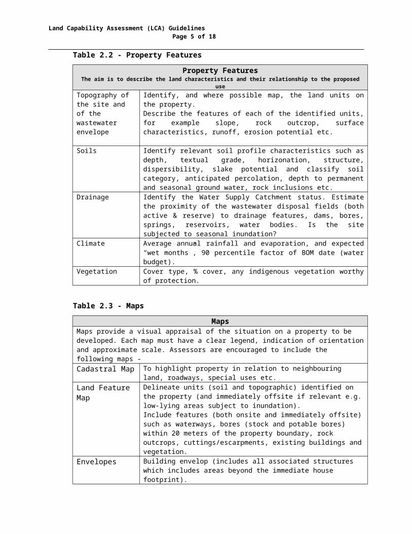
Table 2.2 - Property FeaturesProperty Features
The aim is to describe the land characteristics and their relationship to the proposed useTopography of the site and of the wastewater envelope
Identify, and where possible map, the land units on the property.Describe the features of each of the identified units, for example slope, rock outcrop, surface characteristics, runoff, erosion potential etc.
Soils Identify relevant soil profile characteristics such as depth, textual grade, horizonation, structure, dispersibility, slake potential and classify soil category, anticipated percolation, depth to permanent and seasonal ground water, rock inclusions etc.
Drainage Identify the Water Supply Catchment status. Estimate the proximity of the wastewater disposal fields (both active & reserve) to drainage features, dams, bores, springs, reservoirs, water bodies. Is the site subjected to seasonal inundation?
Climate Average annual rainfall and evaporation, and expected “wet months”, 90 percentile factor of BOM date (water budget).
Vegetation Cover type, % cover, any indigenous vegetation worthy of protection.
Table 2.3 - MapsMaps
Maps provide a visual appraisal of the situation on a property to be developed. Each map must have a clear legend, indication of orientation and approximate scale. Assessors are encouraged to include the following maps -Cadastral Map To highlight property in relation to neighbouring land, roadways,
special uses etc.Land Feature Map
Delineate units (soil and topographic) identified on the property (and immediately offsite if relevant e.g. low-lying areas subject to inundation).Include features (both onsite and immediately offsite) such as waterways, bores (stock and potable bores) within 20 meters of the property boundary, rock outcrops, cuttings/escarpments, existing buildings and vegetation.
Envelopes Building envelop (includes all associated structures which includes areas beyond the immediate house footprint).Wastewater envelope (area for wastewater disposal should also include a reserve area should the primary area fail). The size of the wastewater envelope is governed by the soil type and the wastewater treatment process. This area could be 241sqm for a wastewater treatment plant on a category 1 soil type to 488sqm for a wastewater treatment plant on a category 6 soil type.
Land Capability Assessment (LCA) GuidelinesPage 5 of 13
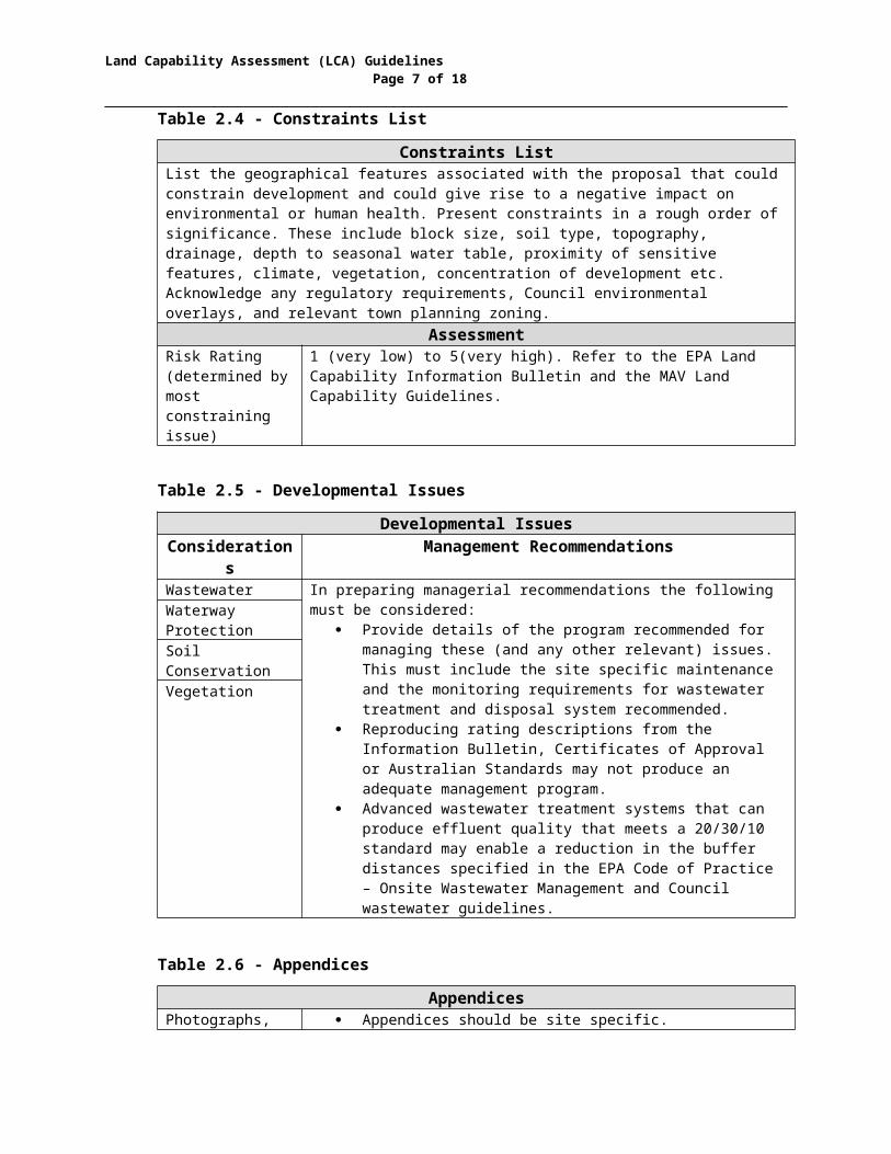
Table 2.4 - Constraints ListConstraints List
List the geographical features associated with the proposal that could constrain development and could give rise to a negative impact on environmental or human health. Present constraints in a rough order of significance. These include block size, soil type, topography, drainage, depth to seasonal water table, proximity of sensitive features, climate, vegetation, concentration of development etc. Acknowledge any regulatory requirements, Council environmental overlays, and relevant town planning zoning.
AssessmentRisk Rating (determined by most constraining issue)
1 (very low) to 5(very high). Refer to the EPA Land Capability Information Bulletin and the MAV Land Capability Guidelines.
Table 2.5 - Developmental IssuesDevelopmental Issues
Considerations
Management Recommendations
Wastewater In preparing managerial recommendations the following must be considered:
Provide details of the program recommended for managing these (and any other relevant) issues. This must include the site specific maintenance and the monitoring requirements for wastewater treatment and disposal system recommended.
Reproducing rating descriptions from the Information Bulletin, Certificates of Approval or Australian Standards may not produce an adequate management program.
Advanced wastewater treatment systems that can produce effluent quality that meets a 20/30/10 standard may enable a reduction in the buffer distances specified in the EPA Code of Practice – Onsite Wastewater Management and Council wastewater guidelines.
Waterway ProtectionSoil ConservationVegetation
Table 2.6 - AppendicesAppendices
Photographs, tables etc
Appendices should be site specific. General material, such as extensive regional plant lists,
may include irrelevant information. Manufacturer’s brochures are generally considered
nothing more than “padding” and may not support the applicant’s proposal.

Land Capability Assessment (LCA) GuidelinesPage 6 of 13
3. Requirements for Land Capability Assessments
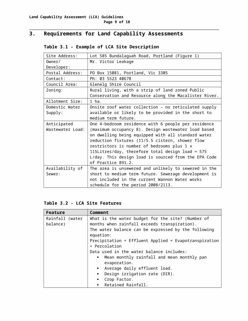
Table 3.1 - Example of LCA Site DescriptionSite Address: Lot 585 Bundalaguah Road, Portland (Figure 1)Owner/ Developer: Mr. Victor LeakagePostal Address: PO Box 15081, Portland, Vic 3305Contact: Ph: 03 5523 40678Council Area: Glenelg Shire CouncilZoning: Rural living, with a strip of land zoned Public Conservation and
Resource along the Macalister River.Allotment Size: 1 ha.Domestic Water Supply:
Onsite roof water collection – no reticulated supply available or likely to be provided in the short to medium term future.
Anticipated Wastewater Load:
One 4-bedroom residence with 6 people per residence (maximum occupancy 8). Design wastewater load based on dwelling being equipped with all standard water reduction fixtures (11/5.5 cistern, shower flow restrictors is number of bedrooms plus 1 x 115Litres/day, therefore total design load = 575 L/day. This design load is sourced from the EPA Code of Practice 891.2.
Availability of Sewer:
The area is unsewered and unlikely to sewered in the short to medium term future. Sewerage development is not included in the current Wannon Water works schedule for the period 2008/2113.
Table 3.2 - LCA Site FeaturesFeature CommentRainfall (water balance)
What is the water budget for the site? (Number of months when rainfall exceeds transpiration).The water balance can be expressed by the following equation:Precipitation + Effluent Applied = Evapotranspiration + PercolationData used in the water balance includes:
Mean monthly rainfall and mean monthly pan evaporation.
Average daily effluent load. Design irrigation rate (DIR). Crop Factor. Retained Rainfall.
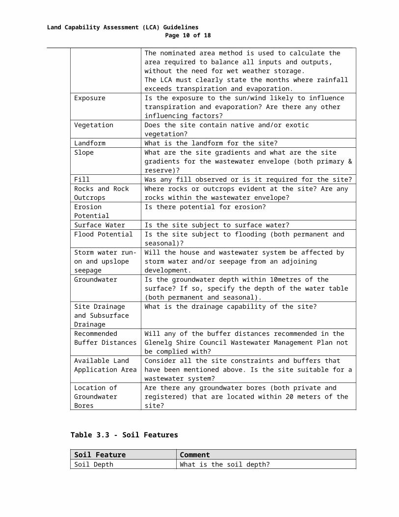
The nominated area method is used to calculate the area required to balance all inputs and outputs, without the need for wet weather storage.The LCA must clearly state the months where rainfall exceeds transpiration and evaporation.
Exposure Is the exposure to the sun/wind likely to influence transpiration and evaporation? Are there any other influencing factors?
Vegetation Does the site contain native and/or exotic vegetation?Landform What is the landform for the site?Slope What are the site gradients and what are the site gradients for
the wastewater envelope (both primary & reserve)?Fill Was any fill observed or is it required for the site?
Land Capability Assessment (LCA) GuidelinesPage 7 of 13
Rocks and Rock Outcrops
Where rocks or outcrops evident at the site? Are any rocks within the wastewater envelope?
Erosion Potential Is there potential for erosion?Surface Water Is the site subject to surface water?Flood Potential Is the site subject to flooding (both permanent and seasonal)?Storm water run-on and upslope seepage
Will the house and wastewater system be affected by storm water and/or seepage from an adjoining development.
Groundwater Is the groundwater depth within 10metres of the surface? If so, specify the depth of the water table (both permanent and seasonal).
Site Drainage and Subsurface Drainage
What is the drainage capability of the site?
Recommended Buffer Distances
Will any of the buffer distances recommended in the Glenelg Shire Council Wastewater Management Plan not be complied with?
Available Land Application Area
Consider all the site constraints and buffers that have been mentioned above. Is the site suitable for a wastewater system?
Location of Groundwater Bores
Are there any groundwater bores (both private and registered) that are located within 20 meters of the site?
Table 3.3 - Soil Features
Soil Feature CommentSoil Depth What is the soil depth?Coarse Fragments (%) Are coarse fragments observed and in what
percentage (%)?Soil Permeability and Design Loading Rates
What is the soil permeability and design loading rates?Topsoil’s (depth to 200mm)
Subsoil’s (Depth from 200 – 600mm)
Description Describe soil type. Describe soil type.Soil Category (AS/NZ 1547:2000)
What is the Soil Category? What is the Soil Category?
Design Loading Rate (DLR mm/day)
What is the DLR mm/day? What is the DLR mm/day?
Design Loading Rate (DLR mm/day) for trenches/beds
What is the DLR mm/day for trenches/beds?
What is the DLR mm/day for trenches/beds?
pH What is the pH of the site?Electrical Conductivity What is the electrical conductivity of the site?
3.1 Soil Category and Effluent Design Loading Rate

Land Capability Assessment (LCA) GuidelinesPage 8 of 13
What is the soil category and the proposed effluent loading rates for the proposed dwelling? The table below lists the soil categories as specified in the Australian Standard 1546:2008 and also includes the effluent design loading rates specified in Council’s Wastewater Management Plan.
To assist you Council’s Wastewater Management Plan has specified the soil category within the townships and specified the applicable design loading rates for these townships.
Table 3.4 - Soil Category and Effluent Design Loading Rate
Soil CategoryAS/NZ 1546:2008
Soil Type Design Loading RateSeptic Tank Wastewater
Treatment Plant1 Sand & Gravel Not Suitable 52 Sandy Loams 20 53 Loams 15 44 Clay Loams 10 3.575 Light Clays 5 2.866 Medium to Heavy
Clays5 2.14
Refer to the Table 3.1 & 3.2 in Council’s Wastewater Management Plan.
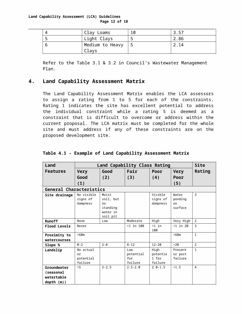
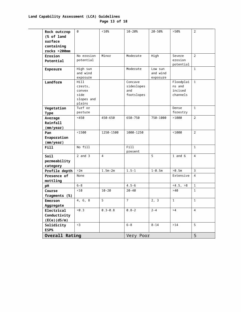
4. Land Capability Assessment Matrix
The Land Capability Assessment Matrix enables the LCA assessors to assign a rating from 1 to 5 for each of the constraints. Rating 1 indicates the site has excellent potential to address the individual constraint while a rating 5 is deemed as a constraint that is difficult to overcome or address within the current proposal. The LCA matrix must be completed for the whole site and must address if any of these constraints are on the proposed development site.
Table 4.1 - Example of Land Capability Assessment Matrix
Land Features
Land Capability Class Rating Site RatingVery
Good (1)
Good (2)
Fair (3) Poor (4)
Very Poor (5)
General CharacteristicsSite drainage No visible
signs of dampness
Moist soil, but no standing water in soil pit
Visible signs of dampness
Water ponding on surface
3
Runoff None Low Moderate High Very High 2Flood Levels Never <1 in 100 >1 in 100 <1 in 20 3Proximity to watercourses
>60m <60m 1
Slope % 0-2 2-8 8-12 12-20 >20 2
Land Capability Assessment (LCA) GuidelinesPage 9 of 13
Landslip No actual or potential failure
Low potential for failure
High potential for failure
Present or past failure
1
Groundwater (seasonal watertable depth (m))
>5 5-2.5 2.5-2.0 2.0-1.5 <1.5 4
Rock outcrop (% of land surface containing rocks >200mm
0 <10% 10-20% 20-50% >50% 2
Erosion Potential
No erosion potential
Minor Moderate High Severe erosion potential
2
Exposure High sun and wind exposure
Moderate Low sun and wind exposure
1
Landform Hill crests, convex side slopes and plains
Concave sideslopes and footslopes
Floodplains and incised channels
1
Vegetation Type
Turf or pasture
Dense forestry
1
Average Rainfall (mm/year)
<450 450-650 650-750 750-1000 >1000 2
Pan Evaporation (mm/year)
<1500 1250-1500 1000-1250 <1000 2
Fill No fill Fill present 1Soil permeability category
2 and 3 4 5 1 and 6 4
Profile depth >2m 1.5m-2m 1.5-1 1-0.5m >0.5m 3Presence of mottling
None Extensive 4
pH 6-8 4.5-6 <4.5, >8 1Course fragments (%)
<10 10-20 20-40 >40 1
Emerson Aggregate
4, 6, 8 5 7 2, 3 1 1
Electrical Conductivity (ECe)(dS/m)
<0.3 0.3-0.8 0.8-2 2-4 >4 4
Solidicity ESP%
<3 6-8 8-14 >14 5
Overall Rating Very Poor 5
5. Type of Wastewater System Recommended
Land Capability Assessment (LCA) GuidelinesPage 10 of 13
The LCA must nominate a preferred wastewater treatment system and nominate a management regime for the proposed wastewater treatment system.
The proposed treatment system must include a detailed design for the installation of the wastewater system and specify the location and area required for wastewater disposal.
The management system must include the name and contact details of the person/s contracted to undertake the monitoring during the first two years of the development and must demonstrate how this management system will be sustainable over the life of the treatment system.
6. Management Program for Wastewater System
When the LCA has been approved, and following Council approval to install the proposed wastewater treatment system, Council will then issue an “Approval to Use” certificate.
This “Approval to Use” certificate will contain a number of permit conditions that are based on the Environment Protection Authority’s Certificate of Approval Conditions.
These conditions combined with the management conditions proposed in the LCA will form the basis of the management program to be undertaken by the land owner.
7. Site Plan
The site plan should specify the following: The location of the dwelling, proposed outbuildings and/or structures
(swimming pools, tennis courts, vegetable gardens, driveways, rainwater tanks etc).
The site gradients (if greater than 20% slope, contours to be at 5m intervals).
Location of all water courses, creeks, streams, ocean. Location of any groundwater bores within 20m of the site boundary. Location of wastewater system including the location of the
wastewater envelope. This may include a schematic of disposal envelope and construction design.
8. Size of Wastewater Envelope
To assist applicant’s calculate the area required for the wastewater effluent envelope. Council has provided the area required for a 4 bedroom dwelling

Land Capability Assessment (LCA) GuidelinesPage 11 of 13
and has provided details of the area required for both a septic tank with effluent absorption trenches and or the area required for a wastewater treatment plant with sub surface disposal.
Table 8.1 – Wastewater Envelopes
Soil Categor
y(To a
depth of 450mm)
Soil Description
Area Required (sqm)
Septic (m²) Wastewater Treatment Plant
1 Sand Not suitable 2502 Sandy loam 500 2503 Loans 730 3004 Clay Loans 1200 3505 Light clays 1420 4506 Medium to heavy
claysNot Suitable 510
Table 8.2 – Suitable Treatment System Options by Township
SOIL CATEGORY
TOWNSHIP SEPTIC TANK WASTEWATER TREATMENT PLANT
1 Cape Bridgewater Not suitable 2502a Casterton 500 2502b Dartmoor 500 2502b Digby 500 2501 Dutton Way Not suitable 3504a Heywood 1200 3506b Heywood Not suitable 5106b Merino Not suitable 5101 Neslon Not suitable 250
2b & 3b Sandford 500 3005b Portland 1420 510
Land Capability Assessment (LCA) Guidelines Page 12 of 13
To assist landowner and developers, Council has provided the names and contact details of nine Land Capability Assessors.
These assessors are not endorsed by the Shire and their names and contact details are provided as a point of reference only.
The names of other LCA assessors are located in Victoria phone directory or can be located by undertaking a Google search.
COMPANY ADDRESS TELEPHONE NUMBER
MOBILE FAX E-MAIL
2020 Engineering Solutions 1745 Colac – Forrest Road, Colac 3249
0428141441 52334608 www.2020es.com
Bruce Hollioake & Partners 102 Dawson Street, South Ballarat 3350
(03) 5338 8270
(03) 5338 8202
Civil Test Pty Ltd (Mornington) 10 Latham Street, Mornington 3931 (03) 5975 6644
(03) 5975 9589
Dr. Chris Day 2 Chaucer Street, Box Hill South 3128
(03) 9888 9548
0434 020 853 [email protected]
EWS Environmental 8 Simmons Street, Box Hill North 3129
(03) 9846 0150
(03) 9849 0152
Paladin White Pty Ltd (Bendigo) PO Box 686, Strathfieldsaye, 3581 (03) 5439 3511
0419 189 879 [email protected]
Provincial Geotechnical Pty Ltd (Ballarat) 3 Gnarr Street, Ballarat 3350 (03) 5338 1770
0428 522 408 (03) 5339 6598
Provincial Geotechnical Pty Ltd (Geelong)
PO Box 1161, Geelong 3220 (03) 5223 1566
0428 522 408 (03) 5222 4560
Robert van de graaff & Associates Pty Ltd
14 Linlithgow Street, Mitcham 3132 (03) 9872 4677
0438 456 601 [email protected]
Land Capability Assessors
Land Capability Assessment (LCA) Guidelines Page 13 of 13
Woodhouse Graesser Johnston Pty Ltd 116 Timor Street, Warrnambool 3280 (03) 5562 4930
(03) 5562 0763
Paul Williams & Associates Pty Ltd 0418 171 796