Embed Size (px)
Citation preview

Senior Secondary Geography Fieldwork Central and Sheung Wan Virtual Field Study 1
Virtual Urban Field Study [Mr LIU Hok-him, Aaron, Geography Panel Head,
Christian Alliance SW Chan Memorial College]
Foreword Due to coronavirus disease and related class suspension, many senior secondary geography fieldwork
activities are also suspended but fieldwork is an important part of studying geography. We are a group of
geography teachers who care about the learning needs of our students, so we’d prepared this "virtual
urban field study". This virtual field study is simplified and transformed from an authentic urban field
study with VR (virtual reality) technology. It is hoped that students can still conduct limited virtual
geography field trips while maintaining social distancing at home. However, we understand that this
virtual field study cannot replace ‘real’ fieldwork activities, and we hope that after the epidemic is over,
we can once again lead our students to conduct geography field study in the field.
Background of the study Inner city refers to the fringe of the Central Business District (CBD) where buildings are derelict and
decaying due to lack of planning at the initial stage of development and poor maintenance. It usually
appears in the transition zone between commercial land use and residential land use, where the facilities
of the community are old and the socio-economic status of the residents is declining. Mixed land uses can
be found.
The Central Business District of Hong Kong locates in Central and Sheung Wan area. This virtual field
study comprised of two routes which lie in Central and Sheung Wan respectively. Six checkpoints are
designed along each route (with a total of 12), where 360° panoramic photos are provided. According to
the VR photos of the checkpoints, students are expected to identify the major land use(s), record the
height of the buildings, describe the characteristics of the community, and eventually be able to assess the
‘urban landscape score’ for the study area and delineate the locations of the inner city areas in these two
districts according to the rating (where their scores should be comparatively lower)
Study topic Identify the urban transition zones in Central and Sheung Wan, and describe their relevant characteristics.
Route design / Area of study The starting points of the two routes are marked from the first building located at the waterfront, where
one of the routes is developed along the Central-Mid-Levels Escalator (Central route) and the other is
along the Ladder Street (Sheung Wan route). Six checkpoints located at several similar streets are chosen
along the two routes respectively. The end points are marked north of Conduit Road. Here are the online
maps:
- Route map for the Sheung Wan field study: https://arcg.is/1yOzT1
- Route map for the Central field study: https://arcg.is/1Sjj9n
Fieldwork tasks
Students need to describe the buildings at the four major compass points of each checkpoint (i.e.
observing the east, south, west and north directions from the central point of each panoramic photo),
including:
1. land use(s)
2. building height (estimate the height of the tallest building)
3. building appearance
4. commercial value
5. degree of greening
6. simple text description
Then, score according to your description. According to the distance between the checkpoints and the
coastline, present the scores of the checkpoints with a line graph. Finally, try to summarise the
characteristics of the routes based on your findings in the virtual field study.
Appendix 1

Senior Secondary Geography Fieldwork Central and Sheung Wan Virtual Field Study 2
The part on Sheung Wan was done by teachers for students’ reference. You only need to complete the
part on Central. In order to develop students’ map reading skills, the checkpoint numbers of the Central
field study will not be provided, and the order of some checkpoints has been reversed. You must first
match the checkpoints based on your observation on the characteristics of the streets from the VR photos
and then complete the rest of the tasks accordingly.

Senior Secondary Geography Fieldwork Central and Sheung Wan Virtual Field Study 3
Sheung Wan Field Route (demonstration by teachers)
1. Visit the website of ArcGIS Storymap (https://arcg.is/1zmj9i) and view the VR360° panoramic
photos for the part of Sheung Wan to complete the virtual field study. Mark down your observation by
selecting the most suitable descriptions.
Checkpoints of Sheung Wan
Field Study ( A'-F ' )
Observation
A’: Connaught Road
Brief text description:
This checkpoint locates the closest
to the coastline of Sheung Wan. Its
transport network is the most
convenient (e.g. MTR , tram). The
commercial activities there are
relatively high order.
Identify the most dominant land use(s) (may choose more than one):
commercial land use ☐ industrial land use
☐ institutional land use ☐ recreational land use
transport land use ☐ mixed land use ☐ residential land use
The height of the tallest building in the photo (number of storeys):
☐ 15 or less ☐ 16-40 40 or above
The building appearance (maintenance and design):
☐ Obsolete ☐ average modern
Ordering of shops or apartments: High ☐ Moderate ☐ Low
Degree of greening: ☐ Dense Sparse ☐ Absent
B’:Queen’s Road Central
Brief text description:
This is the starting point of the
Ladder Street, commercial
activities reduce in amount and
order. Residential land use
emerges.
Identify the most dominant land use(s) (may choose more than one):
commercial land use ☐ industrial land use
☐ institutional land use ☐ recreational land use
☐ transport land use mixed land use ☐ residential land use
The height of the tallest building in the photo (number of storeys):
☐ 15 or less 16-40 ☐ 40 or above
The building appearance (maintenance and design):
☐ Obsolete ☐ average modern
Ordering of shops or apartments: ☐ High Moderate ☐ Low
Degree of greening: ☐ Dense Sparse ☐ Absent

Senior Secondary Geography Fieldwork Central and Sheung Wan Virtual Field Study 4
C’:Hollywood Road
(Man Mo Temple)
Brief text description:
The buildings are much older and
in poorer conditions. The average
height of the buildings is much
lower. Local shops are found on
the ground floors and coffin shops
which are not welcomed by
residents are spotted.
Identify the most dominant land use(s) (may choose more than one) :
☐ commercial land use ☐ industrial land use
institutional land use ☐ recreational land use
☐ transport land use mixed land use ☐ residential land use
The height of the tallest building in the photo (number of storeys):
☐ 15 or less 16-40 ☐ 40 or above
The building appearance (maintenance and design):
Obsolete ☐ average ☐ modern
Ordering of shops or apartments: ☐ High ☐ Moderate Low
Degree of greening: ☐ Dense Sparse ☐ Absent
D’: Wing Lee Street
Brief text description:
This site was originally planned
for redevelopment, yet after the
success of the movie ‘Echoes of
the Rainbow’, the Urban Renewal
Authority (URA) was prompted to
preserve and revitalise few of the
tenement buildings. However, the
neighbouring building blocks
have been redeveloped.
Identify the most dominant land use(s) (may choose more than one):
☐ commercial land use ☐ industrial land use
☐ institutional land use ☐ recreational land use
☐ transport land use mixed land use residential land use
The height of the tallest building in the photo (number of storeys):
☐ 15 or less 16-40 ☐ 40 or above
The building appearance (maintenance and design):
☐ Obsolete average ☐ modern
Ordering of shops or apartments: ☐ High Moderate ☐ Low
Degree of greening: ☐ Dense Sparse ☐ Absent
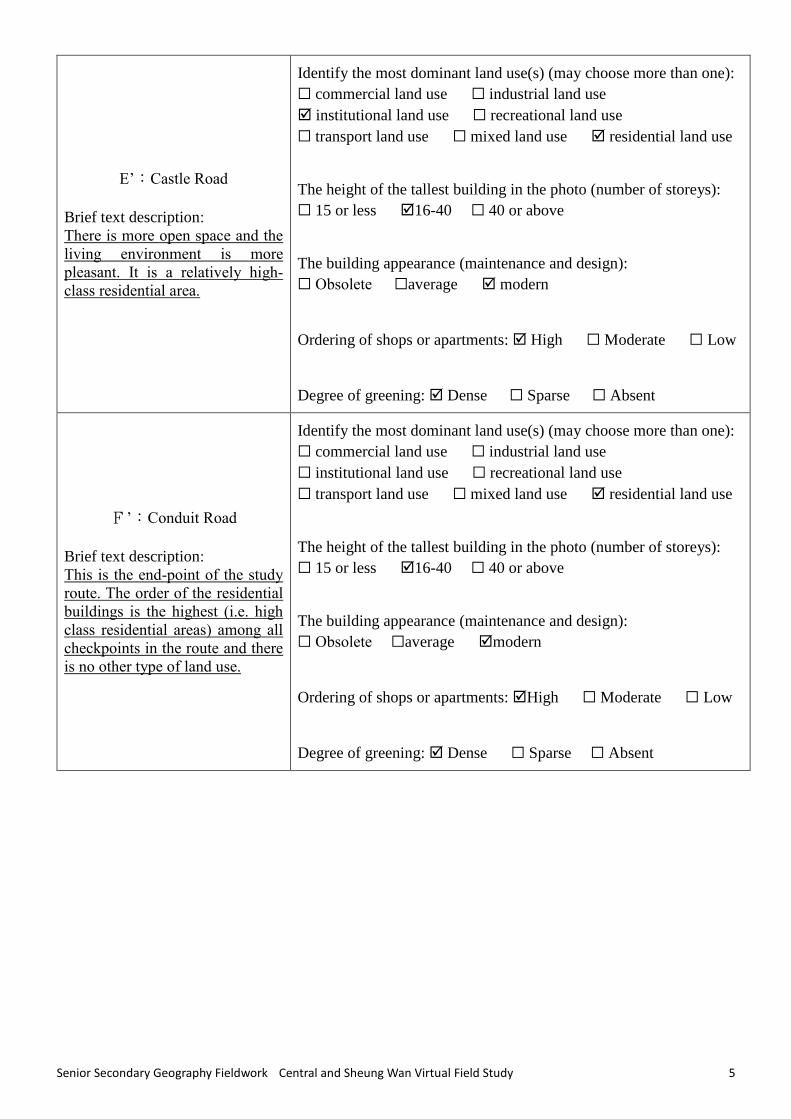
Senior Secondary Geography Fieldwork Central and Sheung Wan Virtual Field Study 5
E’:Castle Road
Brief text description:
There is more open space and the
living environment is more
pleasant. It is a relatively high-
class residential area.
Identify the most dominant land use(s) (may choose more than one):
☐ commercial land use ☐ industrial land use
institutional land use ☐ recreational land use
☐ transport land use ☐ mixed land use residential land use
The height of the tallest building in the photo (number of storeys):
☐ 15 or less 16-40 ☐ 40 or above
The building appearance (maintenance and design):
☐ Obsolete ☐average modern
Ordering of shops or apartments: High ☐ Moderate ☐ Low
Degree of greening: Dense ☐ Sparse ☐ Absent
F’:Conduit Road
Brief text description:
This is the end-point of the study
route. The order of the residential
buildings is the highest (i.e. high
class residential areas) among all
checkpoints in the route and there
is no other type of land use.
Identify the most dominant land use(s) (may choose more than one):
☐ commercial land use ☐ industrial land use
☐ institutional land use ☐ recreational land use
☐ transport land use ☐ mixed land use residential land use
The height of the tallest building in the photo (number of storeys):
☐ 15 or less 16-40 ☐ 40 or above
The building appearance (maintenance and design):
☐ Obsolete ☐average modern
Ordering of shops or apartments: High ☐ Moderate ☐ Low
Degree of greening: Dense ☐ Sparse ☐ Absent

Senior Secondary Geography Fieldwork Central and Sheung Wan Virtual Field Study 6
2. Refer to the online map for the route in Sheung Wan: https://arcg.is/1yOzT1
3. Based on the data collected and your descriptions, rate the ‘Urban landscape score’ for each
checkpoint (0 is the lowest score, 2 being the highest score ) :
A’ B’ C’ D’ E’ F’
Distance from the coastline to
the checkpoint (m)
100 400 480 560 790 870
Choose ONE land use to
represent this zone
Commercial Commercial Mixed Mixed Residential Residential
Building height (scores
increase with height)
2 1 1 1 1 1
Building appearance 2 2 0 1 2 2
Commercial value 2 1 0 1 2 2
Degree of greening 1 1 1 1 2 2
Total score 7 5 2 4 7 7
4. Draw a line graph which plots the “total urban landscape score” of each checkpoint against its
“distance from the coastline”.*
5. Summary: Identify and describe the urban transition zone of the Sheung Wan route in the above virtual
field study.
The transition zone of the Sheung Wan field route should be found around Checkpoint C’, on Hollywood
Road, close to Man Mo Temple, since the urban landscape score of Checkpoint C’ is the lowest and mixed
land use emerges. In general, commercial land use should be the dominant type of land use in the central
business district and the average building height there should be the tallest among other land uses. Most of
the buildings in the Mid-levels had undergone redevelopment, thus the height and the commercial value of
the buildings have subsequently increased. Yet, commercial activities are absent in Checkpoint C’and it is
* The line
graph is
divided into
sections of
different
colours to
indicate the
changes in the
distribution of
land uses along
the route

Senior Secondary Geography Fieldwork Central and Sheung Wan Virtual Field Study 7
not the central business district. Taller buildings after redevelopment are also absent and the order of shops
is generally low (e.g. coffin shops), thus the transition zone of Sheung Wan should be found around
Checkpoint C’.

Senior Secondary Geography Fieldwork Central and Sheung Wan Virtual Field Study 8
Central Field Route
1. Visit the website of ArcGIS Storymap (https://arcg.is/1zmj9i) and view the VR360° panoramic
photos for the part of Central to complete the virtual field study. Mark down your observation by
selecting the most suitable descriptions. (Note: The checkpoints are not in correct order.)
Checkpoints of Central Observation
Queen’s Road Central
Brief text description:
Idenitify the most dominant land use(s) (may choose more than one):
☐ commercial land use ☐ industrial land use
☐ institutional land use ☐ recreational land use
☐ transport land use ☐ mixed land use ☐ residential land use
The height of the tallest building in the photo (number of storeys):
☐ 15 or less ☐16-40 ☐ 40 or above
The building appearance (maintenance and design):
☐ Obsolete ☐average ☐ modern
Ordering of shops or apartments: ☐ High ☐ Moderate ☐ Low
Degree of greening: ☐ Dense ☐ Sparse ☐ Absent
Man Cheung Street
Brief text description:
Identify the most dominant land use(s) (may choose more than one):
☐ commercial land use ☐ industrial land use
☐ institutional land use ☐ recreational land use
transport land use ☐ mixed land use ☐ residential land use
* One of them has been provided by the teacher
The height of the tallest building in the photo (number of storeys):
☐ 15 or less ☐16-40 ☐ 40 or above
The building appearance (maintenance and design):
☐ Obsolete ☐average ☐ modern
Ordering of shops or apartments: ☐ High ☐ Moderate ☐ Low
Degree of greening: ☐ Dense ☐ Sparse ☐ Absent

Senior Secondary Geography Fieldwork Central and Sheung Wan Virtual Field Study 9
Rednaxela Terrace
Brief text description:
Identify the most dominant land use(s) (may choose more than one):
☐ commercial land use ☐ industrial land use
institutional land use ☐ recreational land use
☐ transport land use ☐ mixed land use ☐ residential land use
* One of them has been provided by the teacher
The height of the tallest building in the photo (number of storeys):
☐ 15 or less ☐16-40 ☐ 40 or above
The building appearance (maintenance and design):
☐ Obsolete ☐average ☐ modern
Ordering of shops or apartments: ☐ High ☐ Moderate ☐ Low
Degree of greening: ☐ Dense ☐ Sparse ☐ Absent
Hollywood Road
Brief text description:
Identify the most dominant land use(s) (may choose more than one):
☐ commercial land use ☐ industrial land use
☐ institutional land use ☐ recreational land use
☐ transport land use ☐ mixed land use ☐ residential land use
The height of the tallest building in the photo (number of storeys):
☐ 15 or less ☐16-40 ☐ 40 or above
The building appearance (maintenance and design):
☐ Obsolete ☐average ☐ modern
Ordering of shops or apartments: ☐ High ☐ Moderate ☐ Low
Degree of greening: ☐ Dense ☐ Sparse ☐ Absent

Senior Secondary Geography Fieldwork Central and Sheung Wan Virtual Field Study 10
Elgin Street
Brief text description:
Identify the most dominant land use(s) (may choose more than one):
☐ commercial land use ☐ industrial land use
☐ institutional land use ☐ recreational land use
☐ transport land use ☐ mixed land use ☐ residential land use
The height of the tallest building in the photo (number of storeys):
☐ 15 or less ☐16-40 ☐ 40 or above
The building appearance (maintenance and design):
☐ Obsolete ☐average ☐ modern
Ordering of shops or apartments: ☐ High ☐ Moderate ☐ Low
Degree of greening: ☐ Dense ☐ Sparse ☐ Absent
Conduit Road
Brief text description:
Identify the most dominant land use(s) (may choose more than one):
☐ commercial land use ☐ industrial land use
☐ institutional land use ☐ recreational land use
☐ transport land use ☐ mixed land use ☐ residential land use
The height of the tallest building in the photo (number of storeys):
☐ 15 or less ☐16-40 ☐ 40 or above
The building appearance (maintenance and design):
☐ Obsolete ☐average ☐ modern
Ordering of shops or apartments: ☐ High ☐ Moderate ☐ Low
Degree of greening: ☐ Dense ☐ Sparse ☐ Absent
Senior Secondary Geography Fieldwork Central and Sheung Wan Virtual Field Study 11
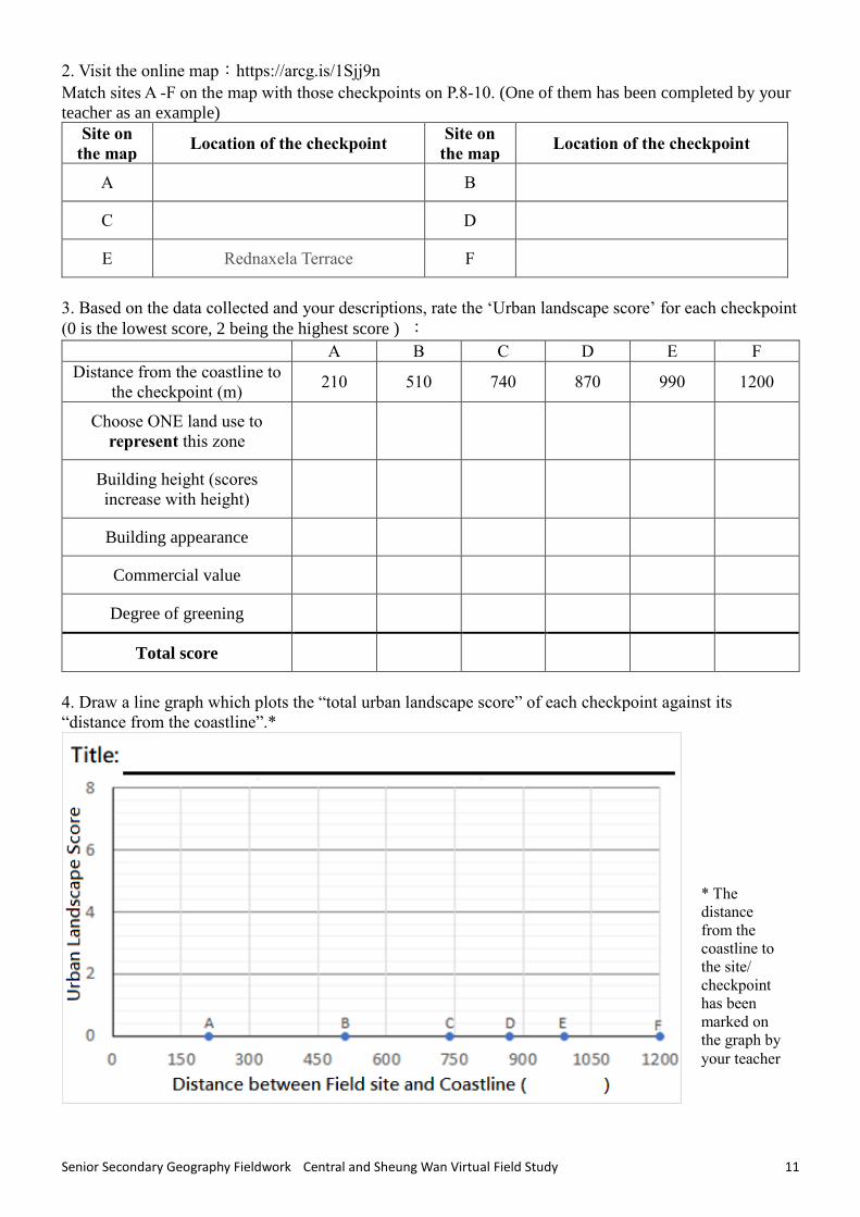
2. Visit the online map:https://arcg.is/1Sjj9n
Match sites A -F on the map with those checkpoints on P.8-10. (One of them has been completed by your
teacher as an example)
Site on
the map Location of the checkpoint
Site on
the map Location of the checkpoint
A B
C D
E Rednaxela Terrace F
3. Based on the data collected and your descriptions, rate the ‘Urban landscape score’ for each checkpoint
(0 is the lowest score, 2 being the highest score ) :
A B C D E F
Distance from the coastline to
the checkpoint (m) 210 510 740 870 990 1200
Choose ONE land use to
represent this zone
Building height (scores
increase with height)
Building appearance
Commercial value
Degree of greening
Total score
4. Draw a line graph which plots the “total urban landscape score” of each checkpoint against its
“distance from the coastline”.*
* The
distance
from the
coastline to
the site/
checkpoint
has been
marked on
the graph by
your teacher

Senior Secondary Geography Fieldwork Central and Sheung Wan Virtual Field Study 12
5. Summary: Identify and describe the urban transition zone in Central in the above virtual field study.
_____________________________________________________________________________________
_____________________________________________________________________________________
_____________________________________________________________________________________
_____________________________________________________________________________________
_____________________________________________________________________________________
[Hints] The summary above should include:
1. Location 2. Major land use(s) 3. Building heights, outlook and the related order 4. Surrounding
environment
Conclusion:
Explain the characteristics of the transition zones in Sheung Wan and Central in the above virtual field
study with reference to their locations, land uses, building heights, building appearance, order of shops
and so on.
_____________________________________________________________________________________
_____________________________________________________________________________________
_____________________________________________________________________________________
_____________________________________________________________________________________
_____________________________________________________________________________________
_____________________________________________________________________________________
Reference and Acknowledgements
Routing and Translation: Mr CHAN Y.Y.
Proof-reading:Mr LUI C.K.
The methodology adopted in this virtual field study is adapted from the contents of the following
geography fieldwork of Ho Koon Nature Education cum Astronomical Centre:
- Sustainable Urban Development: http://www.hokoon.edu.hk/download/geography/ESA2.0_Urban_e.pdf
- Tung Chung Urban Development: http://www.hokoon.edu.hk/download/geography/ESA_TungChung_e.pdf
Special thanks for the suggestions of Mr Lo and the coworkers of the Centre.
For related teaching plan and design ideas, please refer to the “STEM Education and e-Learning Award
Scheme” award winning lesson plan (in Chinese only):
https://www.ggthk.org/stem_hub/course/286/1578294296_1577948148314.pdf