Embed Size (px)
Citation preview

FY 2021-2025 ACTION PLAN
THE MISSION TO END TRAFFIC FATALITIES AND SERIOUS INJURIES BY 2030
Vision Zero

The High Cost of Traffic Fatalities
In 2018, 36,560 people were killed in traffic crashes in the United States while approximately 4.5
million were injured.
“The economic costs of these crashes totaled $242 billion.
Included in these losses are lost productivity, medical costs, legal
and court costs, emergency service costs (EMS), insurance
administration costs, congestion costs, property damage, and
workplace losses”
– NHTSA (Blincoe)
The high financial cost is only part of the tragedy of a fatal crash; inevitably children are left without parents, parents lose children, and, in many cases, whole families are killed in crashes…
…and every single crash was preventable.
2

City Council
President John ‘Jack’ R. Heath
D.3
CouncilwomanAngela Blake D.5
CouncilwomanMichele Gregory D.4
Vice President Muir Boda D.2
CouncilwomanApril R. Jackson D.1
City Administration
MayorJacob R. Day
City AdministratorJulia Glanz
Deputy City AdministratorAndy Kitzrow

4
The Authors and Contributors of the
Action Plan
Author• William White – Transportation Projects Specialist, Infrastructure & Development
Principle Reviewer & Oversight• Amanda Pollack, P.E.–Director, Infrastructure & Development
City Agency Contributors• Bill Sterling – Field Operations• Chief James Gladwell - Deputy Chief, Salisbury Fire Department• John O’Brien – Asst. Director for GIS, Information Services• Everett Howard – Director, Housing & Community Development• Kevin Lindsay – Neighborhood Relations, Housing & Community Development• Dan Hogg – Code Compliance, Housing & Community Development
Partner Agency Contributors• Eric Berkheimer, Salisbury University• Lt. Joel Davies, Salisbury University Police Department• Bicycle Pedestrian and Advisory Committee
• John Foley – Chair• Sandy Pope Co-Chair• Marion Keenan• Mary Buffington• Alex McRae• Melissa Wilson
Peer Reviewer (From Outside Agency)• Jana Potvin –Assistant District Engineer-Traffic MDOT-SHA, District 1
A Special thanks to the RAVEN Team from the GIS Program at Washington College for their efforts in data research and compilation which made this plan possible and to MDOT-MVA Highway Safety Office who funds RAVEN and ensures the data flow continues

Table of Contents
5
6 - A Message from the Mayor9 - Why Vision Zero?10 - The Numbers11 - Our Mission12 - The Team13 - What is Vision Zero?15- How Did the City get to Vision Zero16-The Fundamental Principles of Vision Zero17 - How is Vision Zero Different?18 – The Components of Vision Zero21 - The Data
26 - Crashes of Focus27- Not All Streets were Designed Equal
28 - The High-Injury Network38 - Communities of Concern40 - Taking Action
41 - Our Goals42 - Working with our Partners45 - Reducing Speeds to Safe Levels48 - Eliminating Fatalities on the HIN52 - Reducing Overall Crashes &
Eliminating Serious and Fatal Crashes
58- Reducing Vehicle Miles Traveled62- Increasing Education &
Understanding65 - In Closing66 - References

A Message from The Mayor
6
40,000 people.
Forty Thousand. That’s how many Americans died in crashes last year. And the year before.
Forty Thousand every year. The first thought that probably comes to mind when you hear that
number probably is, “well, not here, not in Salisbury, not in my little town,” and then you realize
that in the last three years, eight of our neighbors, our friends, were killed in crashes. Eight
families will never see their loved ones again. Eight companies lost cherished co-workers. Eight
neighborhoods became just a little bit smaller.
Fifty-three of our neighbors had their lives irrevocably changed when they were involved in
crashes that left them seriously injured in those three years. Fifty-three lives forever changed.
135 of the people who we see everyday suffered some sort of injury just for riding their bike or
walking down the street. Every single one of these incidents were preventable.
It must stop, and it must stop now.
As Mayor, as a resident of our beloved City, and as father, I am proud to present our mission,
our commitment to you; Vision Zero – the end of traffic fatalities and serious injuries on City
Streets by January 1, 2030.
Over the last year, I have instructed the City staff to come together, study what other great
cities have done before us and produce the document that you now have in front of you,
Salisbury’s Vision Zero Action Plan. The Plan is meant to be a living document that evolves with
technologies and techniques that ensure safe travel for all, and it will guide our staff as they
work toward a safer transportation network for everyone. Along the way, some amazing
partners joined our team; Salisbury University and the Salisbury University Police Department
have made the commitment to stand by us. MDOT-SHA and MDOT-MVA have lent their support
and assistance and will continue to do so as we strive Toward Zero Deaths together.
Every resident of our City deserves freedom from the fear that they may be killed or seriously
injured by an automobile. No one should fear walking down their street. No child should fear
taking their bike out of their yard. No one should fear their commute to work. Everyone has the
basic right to the freedom of safe mobility in their own community. The days of prioritizing the
speed of the automobile over the safety of human beings end here. We now proudly join the
Vision Zero Community, a group of cities that is growing across our nation and the world.
Together, our cities will take the steps necessary to do the right thing, as hard as those may
sometime be, in order to make sure our children will never have to fear the world beyond their
front steps ever again.
This Plan was created with all our heart and soul to
do right by you, our neighbors.
Mayor Jake Day

7

8

Why Vision Zero?Salisbury is in a unique position. While Salisbury is a small city, it remains the regional hub of the Eastern Shore of Maryland and as such, the City serves the same purpose of an employment, institutional and service center that much larger cities typically fulfill in other areas. While Salisbury has an approximate population of 32,809 people (2018 est.); it is also home to a student population of nearly 9,000 for the majority of the year (whose families entrust us with their safety); serves as the weekday work destination for a vast swath of the region’s residents; and serves as the hub where visitors passing through the region on their way to the beach, in an area of fourteen square miles.
Salisbury manages to achieve that with a relatively small number of fatalities and serious injuries compared to some areas; however, every single fatality leaves a trail of devastation behind and serious injury - causing crashes leave our neighbors debilitated, financially ruined and can cost the community millions of dollars in lost productivity every year. Couple this with the fact that the same streets causing these tragedies are the same streets that have served as barriers dividing our communities for decades and made our City difficult to walk, bike or enjoy ourselves and the friendship of our neighbors in and the conclusion is obvious. Now is the time to act; now is the time for
Vision Zero.
9
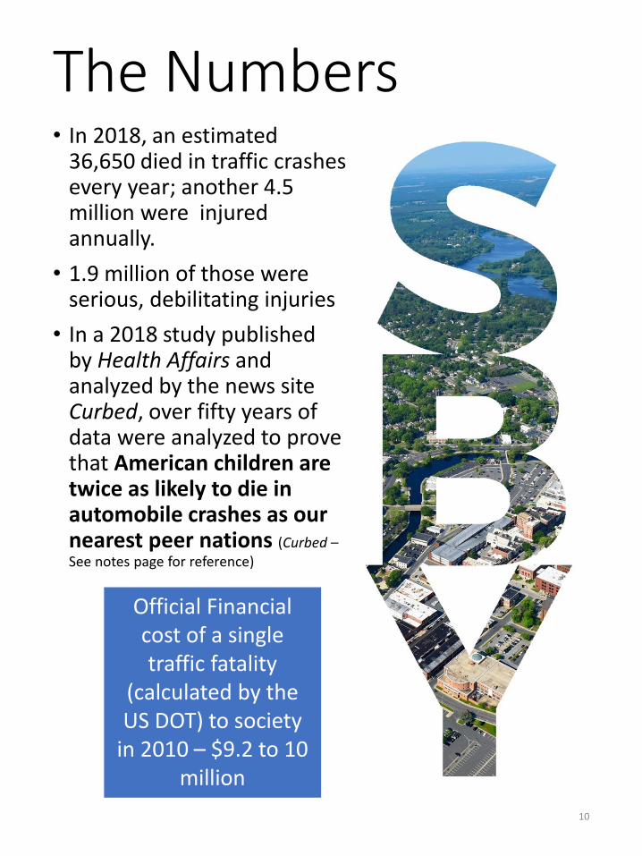
The Numbers• In 2018, an estimated
36,650 died in traffic crashes every year; another 4.5 million were injured annually.
• 1.9 million of those were serious, debilitating injuries
• In a 2018 study published by Health Affairs and analyzed by the news site Curbed, over fifty years of data were analyzed to prove that American children are twice as likely to die in automobile crashes as our nearest peer nations (Curbed –See notes page for reference)
10
Official Financial cost of a single traffic fatality
(calculated by the US DOT) to society
in 2010 – $9.2 to 10 million

Our Mission;An End to Traffic Fatalities and Serious Injuries by 2030Each year, approximately 36,000 people die in traffic crashes across the United States. In Maryland alone, 511 people were killed in 2018. Seven of those deaths occurred in Wicomico County. 783 people were injured in crashes in the County.
We do not have to accept fatal or life altering crashes as inevitable. These crashes are preventable. Safe mobility is a basic right of every citizen of the City of Salisbury, regardless of the mode of travel or the destination. With that in mind, the City of Salisbury is proud to announce our commitment to eliminating traffic deaths and serious injuries by
January 1, 2030.
11
Northwood Dr, looking south
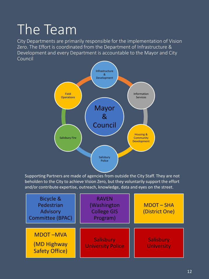
The TeamCity Departments are primarily responsible for the implementation of Vision Zero. The Effort is coordinated from the Department of Infrastructure & Development and every Department is accountable to the Mayor and City Council
12
Mayor &
Council
Infrastructure &
Development
Information Services
Housing & Community
Development
Salisbury Police
Salisbury Fire
Field Operations
Bicycle & Pedestrian Advisory
Committee (BPAC)
RAVEN (Washington College GIS Program)
MDOT – SHA (District One)
MDOT –MVA
(MD Highway Safety Office)
Salisbury University Police
Salisbury University
Supporting Partners are made of agencies from outside the City Staff. They are not beholden to the City to achieve Vision Zero, but they voluntarily support the effort and/or contribute expertise, outreach, knowledge, data and eyes on the street.

How Did the City Get to Vision Zero?• In 1997 AASHTO, the American Association of State Highway Transportation
Officials, published the first National Strategic Highway Safety Plan (SHSP). In
2003 Maryland Followed suit with a State SHSP and began encouraging
Counties to create their own for local roads and streets as well. The method
by which crash reductions were to be achieved were not mandated;
• Simultaneously, in 1997, Sweden officially adopted Vision Zero after three
years of planning with a focus on operating speed reduction;
• Salisbury chose Vision Zero because it is contextually better suited for our
urban environment, it is aggressive in its approach and timeline and is rooted
in equity
1994
Vision Zero Development Begins in Sweden
1997 AASHTO adopts the National SHSP & Sweden
adopts Vision Zero
2003
Maryland adopts its own SHSP
2011
AASHTO Creates the Toward Zero Deaths
Campaign
2014
New York City adopts Vision Zero
2016
Montgomery County, MD adopts Vision Zero
2018
Salisbury begins considering a safety
program and researches Vision Zero
2019
Salisbury Adopts Vision Zero
2020
Salisbury Drafts and Presents its First Vision
Zero Action Plan
13

What is Vision Zero?
Vision Zero is a product of necessity. It is a safety program, rooted in ethics, with the express goal of eliminating traffic deaths and serious injury. Originally developed in Sweden in the 1990’s, the adoption of Vision Zero has cut Swedish traffic fatalities to half and the system has spread throughout Europe. In 2014, New York City became the first US city to adopt Vision Zero. This resulted in their lowest ever recorded crash rate, the largest single-year reduction and the longest sustained reduction in crashes year-over-year. In wake of that success, other American cities have adopted Vision Zero.
14
Last year (2019) Oslo (pop. 1,027,000), the capital of Norway, an early Vision Zero adopter, suffered only one traffic fatality and achieved the goal of ZERO pedestrian or bicycle fatalities. Authorities in Oslo, the first ever municipality to adopt Vision Zero still say that the sole loss of life was too many.
Vision Zero is the recognition that every life matters and that the loss of life does not have to be inevitable in the transpiration system. For too long, we designed our streets and roads to move automobiles as fast as possible, to the detriment of the people who live and work along those same streets and roads. As a society we forgot that the first mission of the transportation network was to serve the public in its entirety, not just the automobile.

What is Vision Zero?
While every city or county adapts Vision Zero to their needs, the fundamental principles are held as a universal truth. Adherence to the Fundamental Principles and the Three Components drive every decision and interaction under the Vision Zero Plan
15
Boston, Denver, San Francisco, Washington, D.C., and even Montgomery County, Maryland are all Vision Zero organizations. In 2019, Maryland became the first state to adopt Vision Zero statewide
Source: Vision Zero Network

The Fundamental Principles of Vision Zero
16
1. Traffic deaths and severe injuries are absolutely preventable and unacceptable. The lives of our neighbors are not a price we must pay;
2. Human life is the ABSOLUTE priority of Transportation system and takes precedence over mobility. The transportation system must be safe for all;
3. Human error is inevitable, and transportation systems should be forgiving and anticipate error;
4. True safety is a systems-level effort and includes safe behavior, education, enforcement and design;
5. Human beings are not capable of surviving the violent impact of traffic crashes and speed is the primary factor in determining survival.
Source—Vision Zero Network
Vision Zero recognizes that there is no such thing as a traffic “accident”. Every single crash is preventable through changes in design, education and choice

How is Vision Zero Different from any other safety
program?
Vision Zero
Data Driven
Verifiable Facts drive every
Decision
Systemic Safety
The focus is on making the
whole system safe
Accountability to Goals
Goals are measurable, and City Officials are held responsible
to meet them
17
Vision Zero is distinguished by uniquely emphasizing Three Components that make it effective when implemented with
full support

Data - Driven
From the focus on reducing automobile speed to the prioritization of projects, every decision is supported by verifiable data. Intersections, corridors and neighborhoods with the highest crash rates are prioritized for projects. The reduction of both automobile speed and speeding (the illegal act of exceeding the posted speed limit) is targeted because speed is the most frequent contributing factor to serious and fatal crashes.
18
The Components of Vision Zero
Waverly Drive, Looking north
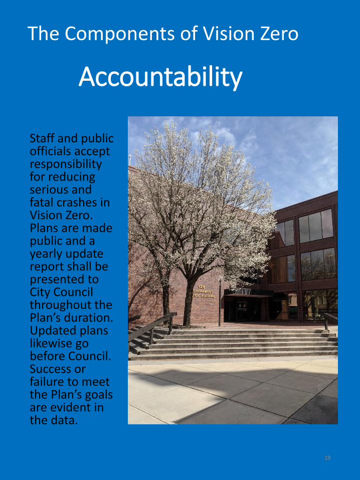
Accountability
Staff and public officials accept responsibility for reducing serious and fatal crashes in Vision Zero. Plans are made public and a yearly update report shall be presented to City Council throughout the Plan’s duration. Updated plans likewise go before Council. Success or failure to meet the Plan’s goals are evident in the data.
19
The Components of Vision Zero

System Designers
Responsible for Safety in System
System Users
Responsible for Following Law and Safe Operation
Failure to Comply/ Failure
of Design
If Users fail to comply or a design proves
less than ideal, designers take new
steps
Systemic Safety• Recognize that people will make mistakes and the transportation
system, in its entirety, must be designed to both minimize mistakes,
and the consequences of those mistakes when they inevitably occur -
death should not be the punishment for error.
• Systemic Safety Recognizes that:
Humans Make Errors
Humans are Vulnerable to Injury
Responsibility is Shared
No Death, or Serious Injury is
Acceptable
Proactive Design is Superior to
Reactive Correction
The Components of Vision Zero

The Network Today
Street Segments
Municipally MaintainedGravel (City)Other Jurisdictions
Municipally Maintained System (Total minus MDOT miles) – 128.7
146.7 Miles of Paved Surface
128.7 mi Maintained by City
18 mi Maintained by State or Private Owners
• The network within City limits is a mix of State, private and City maintained facilities.
• Wicomico County does not control any streets within the City limit. However, the corporate limits are extremely irregular making it possible to drive on a single street/road that enters and exits the City several times
21
A driver traveling from Salisbury University going to northern Salisbury along College Avenue and then continuing onto Beaglin Park Dr will traverse the City/County limits 6 times
The Data

From 2015-2018 there were 3,456 crashes within the City Limits. 1,875 of those crashes occurred on City-controlled streets. All conclusions that follow draw on this crash data unless otherwise noted.
Crashes by Facility Owner 2015-2018
City State Private/Other
The City of Salisbury owns most of the street rights-of-way within the City Limits, however, some of the busiest corridors are overseen by MDOT-SHA. These are;
• US 13 & US 13 Business• US 50 & US 50 Business• Snow Hill Rd (south of Vine Street)• MD 350 - Mt. Hermon Rd.• MD 346 - Old Ocean City Rd.
MDOT-SHA has been a long-term signatory to the Toward Zero Deaths Campaign by AASHTO and MDOT-SHA has actively worked with the City as partners to increase safety for every user.
On April 30,2019 The State of Maryland voted to adopt Vision Zero state-wide with an effective date of October 1, 2019 and as such safety planning at MDOT is currently evolving. As new guidance comes from the State, the City will seek to deepen its existing relationship with MDOT-SHA and integrate its updated Action Plan with that of MDOT.
At this time, the Salisbury Vision Zero Action Plan addresses only the Street Rights-of-Way that are under the City’s direct control.
22
1,875 crashes on City Streets
Citywide Crash Data

Focusing Efforts
23
Breakdown in Crashes on City Streets by Severity (2015-2018)
Fatal or Serious Vehicular Crashes(26)
Crashes Involving People Walking or Biking(98)
Minor Crashes (1,751)
Most crashes are minor “fender-benders” or rear-end collisions with no injuries. While every crash is important, Transportation Staff focus on the areas where serious or fatal crashes are concentrated and on concentration of crashes involving persons walking and biking due to the vulnerability of such users
Focusing Efforts
24
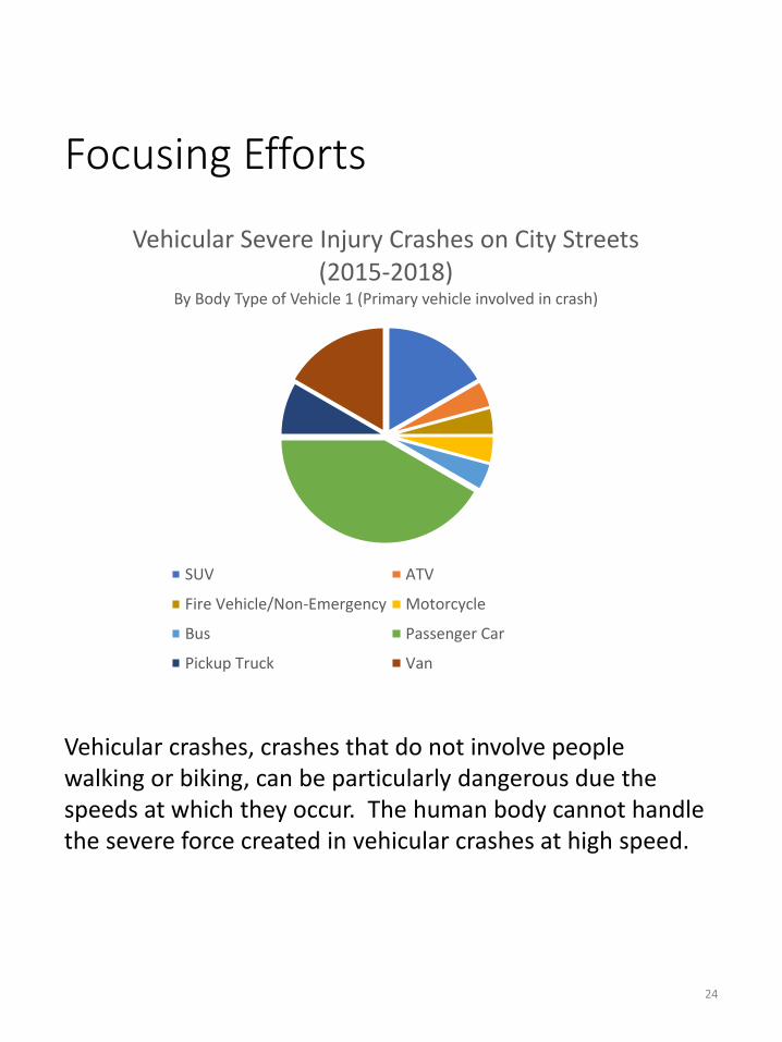
Vehicular Severe Injury Crashes on City Streets (2015-2018)
By Body Type of Vehicle 1 (Primary vehicle involved in crash)
SUV ATV
Fire Vehicle/Non-Emergency Motorcycle
Bus Passenger Car
Pickup Truck Van
Vehicular crashes, crashes that do not involve people walking or biking, can be particularly dangerous due the speeds at which they occur. The human body cannot handle the severe force created in vehicular crashes at high speed.
Focusing Efforts
25
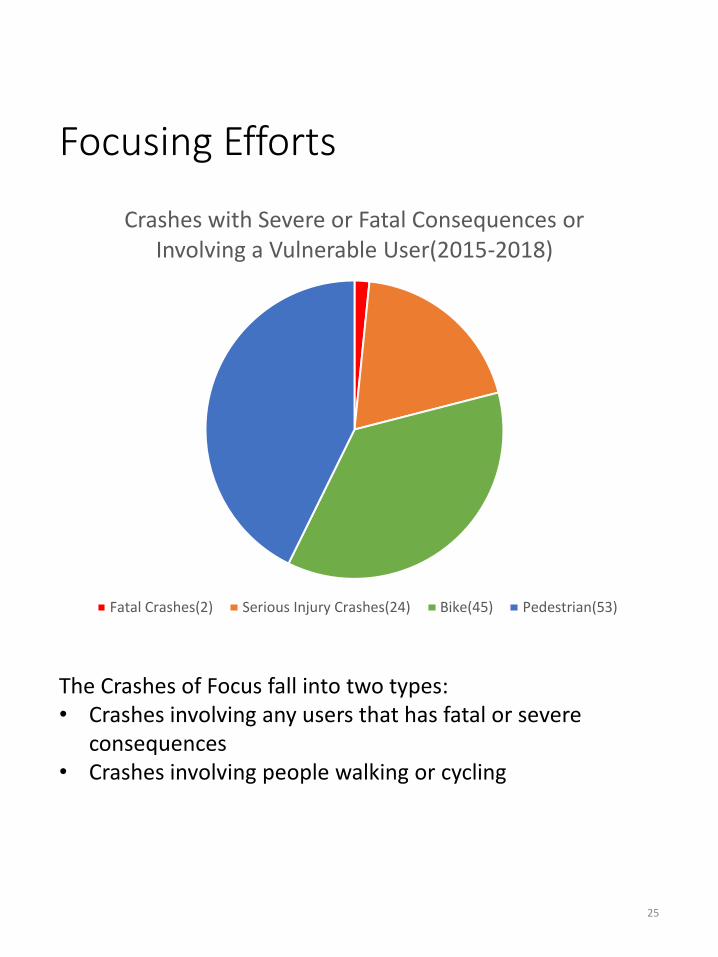
Crashes with Severe or Fatal Consequences or Involving a Vulnerable User(2015-2018)
Fatal Crashes(2) Serious Injury Crashes(24) Bike(45) Pedestrian(53)
The Crashes of Focus fall into two types:• Crashes involving any users that has fatal or severe
consequences• Crashes involving people walking or cycling
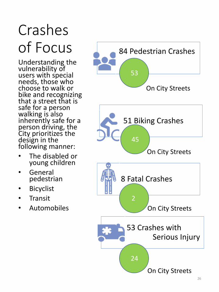
Crashes of Focus 84 Pedestrian Crashes
51 Biking Crashes
8 Fatal Crashes
53 Crashes with Serious Injury
Understanding the vulnerability of users with special needs, those who choose to walk or bike and recognizing that a street that is safe for a person walking is also inherently safe for a person driving, the City prioritizes the design in the following manner:
• The disabled or young children
• General pedestrian
• Bicyclist
• Transit
• Automobiles
26
53
45
2
24
On City Streets
On City Streets
On City Streets
On City Streets

Not All Streets were Designed EqualPost-1940, different City streets were designed to move different levels of traffic as part of a functional classification system; as a result traffic is funneled onto relatively few streets while access was not managed resulting in High-Injury Areas. When designing Highways and Interstates, this created a relatively safe system; when these standards were imported to urban street design, where automobiles mix with all other forms of traffic, it became dangerous. This increased danger is reflected in the High-Injury Network, a relatively small selection of City streets, where most of the City’s crashes occur.
27
Freeways & Expressways
27,000 + AADT
AADT – Average Annual Daily TripsAADT ranges are generalized and based onFHWA Functional Classification Manual Local Street
0-1,000 AADT
Collector1,000-6,300
AADTPrincipal & Minor
Arterials6,000-27,000
AADT

The High Injury Network
• The High Injury Network (HIN) consist of the streets where the majority of fatal and serious-injury causing crashes occur
• The vast majority of the serious or fatal crashes on any street network occur on a small percentage of the streets
• HIN Streets are the areas where the City’s initial efforts will be focused
• City streets are those within City limits that are directly controlled by the City and not the State
Fatal Crashes and serious
injuries occur on
approximately 2% of City
Streets
• Every street in this category except Lake St, carries more than 8,000 auto trips per day. All but Carroll St. have uncontrolled access, meaning a high frequency of driveways
Approximately 50% of Serious Injury Crashes on City Streets occur on just 6.4% of the
City’s Streets
• Meanwhile, 24.5% of bicycle crashes occur on just 3 streets
37.8% of Pedestrian
related crashes occur on just 5
streets
28

The High Injury Network
29
Red – High concentration of all crash typesOrange – Moderate concentration of all crash typesYellow – higher than baseline concentration of all crash types

The High Injury NetworkHigh Crash Corridors- People Walking and Biking
West Isabella Street
West Main Street
East Church Street
30
West Carroll Street
West College Avenue
East Main Street
West Main Street
South Boulevard

The High Injury Network –People Walking & Biking Crashes
31
Carroll St
Mill St
Orange – Moderate concentration of Pedestrian CrashesYellow – higher than baseline concentration of Pedestrian Crashes
Red – High concentration of all Bike CrashesOrange –Moderate concentration of Bike Crashes
Main St at Mill St
In 2019, Helsinki, Finland – a City of 631,695 people and early Vision Zero adopter – eliminated non-driver fatalities while suffering three driver fatalities. Next year, Helsinki hopes to eliminate traffic fatalities entirely

32
Top City Streets with Serious Injury
Crashes
Eastern Shore Drive
East Church Street
The High Injury Network
Top City Streets with Fatal Crashes
Eastern Shore Drive
Naylor Mill Road

The High Injury Network –Top Fatal & Serious Injury Corridors
33
E Church St
Truitt St
College Ave
Main St
Carroll St
Nay
lor
Mill
Rd
Red – City Owned corridor with concentration of Serious Injuries
Black – City-Owned Corridor with Fatal Crash

The High-Injury NetworkTop Concentrations of Intersection CrashesIntersections are where approximately 40% of severe crashes are concentrated nationally, according to FHWA statistics
Top Intersections For All Crashes
• Mill St. at W. Main St.
• Mill St. at Riverside Dr.
• E. Church St. at Truitt St.
Top Intersections for Bicycle Crashes
• W. Isabella St. at W. Main St
• Mill St. at W. Main St.
Top Intersections for Pedestrian Crashes
• Mill St at W. Main St.
• Mill St. at Riverside Dr.
Intersections where Fatal Crashes
Occurred
• Eastern Shore Dr at Washington St.
• Naylor Mill Rd. at Northgate Dr.
34
Eastern Shore Dr. at E. Carroll St.Eastern Shore Dr. at College Ave.Naylor Mill Rd. at Northgate Dr.

The High Injury Network –Intersections
35
Naylor Mill Rd at Northgate Dr
Church St at Truitt St
Eastern Shore Dr at Washington St
Eastern Shore Dr at Carroll St
Eastern Shore Dr at College Ave
W Isabella St at W Main St
Mill St at Main St
Mill St at Riverside/Carroll/Camden
Red – High concentration of all crash typesGreen – High Concentration of Bike crashesBlue – High concentration of Pedestrian CrashesBlack – Fatal Crash Location

High Crash CorridorsAll Crash Types
36
East Church Street
Mill Street
Camden Ave
DUI Citations
Of the 21 corridors with above average DUI citations, all but 4 are also in the High-Injury Network of streets
Red – High concentration of DUI’sOrange – Moderate concentration of DUI’sYellow – higher than baseline concentration of DUI’s

Timing of Crashes (2013-2017)
37
In late 2018, the City requested a study from RAVEN, a data analysis team funded through MDOT, of crash data from 2013-2017 concentrating on timing of crashes. Crashes rates increase all throughout the work day and week, but are much more likely to occur in the afternoon, especially on Thursday and Friday.

Communities of Concern
38
• Areas with high concentrations of crashes also tend to be communities that were historically neglected and contain disproportionate levels of families in the low-moderate income category. This is true nationwide.
• This follows a national trend where the highest crash concentration tend to be in low-mod income areas; the presumed leading cause? These neighborhoods have higher proportions of residents who rely on walking and biking for transportation, and they also were the neighborhoods that were most affected by the high-speed road building practices of previous eras
• A local example: Church St. was once part of the Georgetown Neighborhood, a community that was largely demolished for the construction of US 50 Business
• Because these areas have high concentration of people walking and biking, they are generally prioritized for bike and pedestrian infrastructure
Low-Moderate Income areas or “Low-Mod” areas are neighborhoods that are eligible for Community Development Block Grant (CDBG) funds from the US Department of Housing & Urban Development. They are areas where at least 51% of households have incomes at or below 80% of the area median income. (Source: hud.gov)
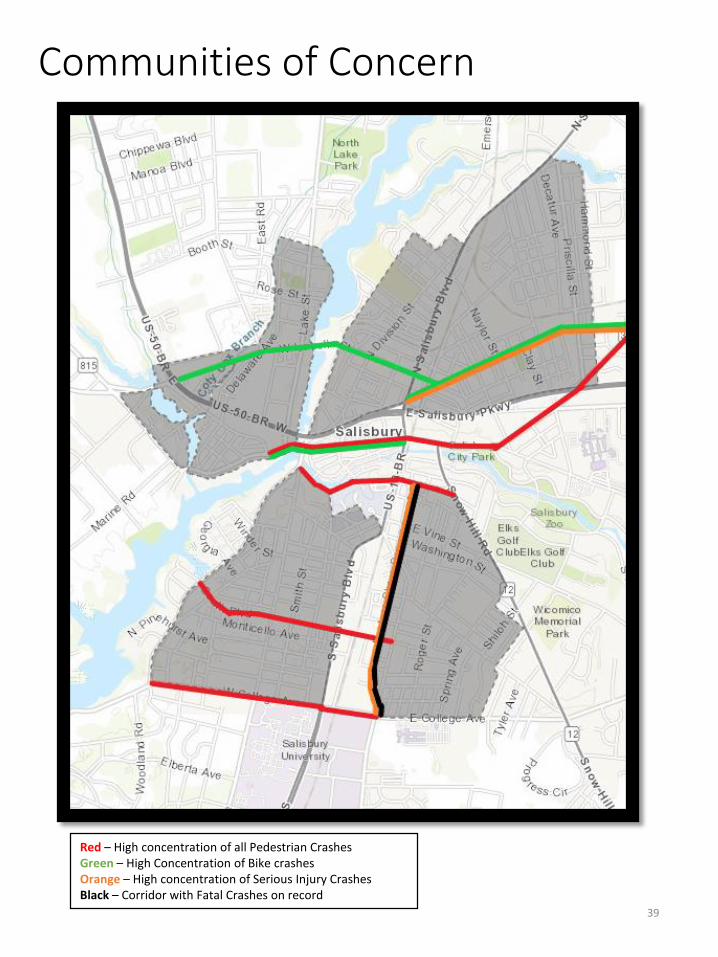
39
Communities of Concern
Red – High concentration of all Pedestrian CrashesGreen – High Concentration of Bike crashesOrange – High concentration of Serious Injury CrashesBlack – Corridor with Fatal Crashes on record

Taking Action
40

Taking Action The City is on a Mission to Eliminate Traffic Fatalities and Serious Injuries by 2030
• Use the Context of each street to set a safe limit
• Reduce occurrences of speeding in the City
Reduce Speeds to Safe Levels
• Enact countermeasures to decrease the severity of crashes when they do occur
• Prioritize Streets in the High Injury Network to eliminate the most dangerous hazards first
Eliminate Fatal Crashes on the High-Injury Network
• Reduce conflict points and manage access
• Design with the principle that humans make mistakes, and mistakes should not be fatal
Reduce occurrences of all crashes on City Streets by
50% by 2030
(5% per year)
• Work to expand Transit and multi-modal options
• Provide multiple safe options for reaching destinations
• Reductions in VMT is directly related to reductions in crashes
Reduce VMT (Vehicle Miles Traveled) by 15% by
2030 (1.5% each year)
• Increase the awareness around the danger of speed
• Help the public adapt to new ways of thinking and design
Educate the Public Expand the Understanding that
Speed is the leading factor in fatal crashes
41
Our Goals to get us there:

Working with our Jurisdictional Partners
42
• The nature of the transportation network means that there are streets in the City Network that are controlled by the City – the vast majority by centerline mile - others that are controlled by MDOT – the largest and busiest –and even some owned and maintained by Salisbury University;
• As such the City does not have jurisdiction everywhere, but all of the jurisdictional partners are committed to working together toward a safer network for all of our residents and the City remains committed to working with them. It is not a hierarchical relationship, but a consortium of equals;
• Each Agency has its own priorities and objectives, however our core mission remains the same; the end of traffic fatalities and severe injuries by 2030.

The Tools at our Disposal -The Five E’s of Vision Zero
• Using Systemic Safety design practices, engineering techniques will be used to reduce the likelihood of crashes, enforcement will be stepped up, to ensure compliance with law and education & outreach will be widespread to make sure citizens understand what we are doing and why. EMS provides and opportunity to preserve life when all else has failed and can provide the most up to date and pertinent information to crash analyses. Data will be used to Evaluate the effectiveness of the Vision Zero program.
Engineering Education
Enforcement EMS
Evaluation
43

How to Read the Action Plan
44
Task
Lead: Support: Other Goals Supported
Action:
Why:
Deadline:
Agency or Partner that will lead the effort on the task
Agency or Partner that will lend support on the task (if any)
The Task to be Completed
What the task will entail
Why the Task matters
Deadline to perform the task
Each Task is appears grouped by which Citywide Goal it primarily supports
Other goals that the task may secondarily accomplish(if any)

Reducing Speed Limits to Safe LevelsSpeed is the largest contributing factor to crash severity. A difference of a few miles per hour can be the difference between life and death. As such, the core of Vision Zero’s effort revolve around reducing the speed of automobiles, and completely separating modes and/or directions of travel wherever possible. Reduction of operating speeds, and sometimes posted speed limits, are the most effective way to reduce severe injuries and fatalities in the transportation network. Excessive speed is the leading contributing cause of such events and the level of speed at the time a crash occurs directly correlates to the survivability of the crash.
45
Source: Vision Zero Network

46
A1. Context Based Speed Limit Analysis
Lead: DID Support: FieldOps Other Goals: Eliminate Fatalities
Action: Using a context-based method of review to begin a study of speed limits throughout the City.
Why: Speed is the largest contributing factor to the severity of crashes. Traditional methods of speed limit review are losing favor nationally as the default method. Context-based methods allow speed limits to be set based on safety, intended use of the right-of-way and the surrounding land use.
Deadline: July 1, 2022
A2. Expansion of the Speed Camera Program
Lead: DID Support: SPD Other Goals: Eliminate Fatalities
Action: Expand use of automated speed enforcement cameras to deter speeding
Why: Placement of additional automated speed cameras will provide a deterrent to speeding along key corridors. State Law currently allows placement of speed cameras in the proximity of schools, which fits with the City’s desire to prioritize school zones for Vision Zero Improvements
Deadline: July 1, 2025
A3. Speed Awareness and Safety Program
Lead: DID Support: SPD Other Goals: Reduce Crashes
Action: Utilize driver feedback signs and educate the public on the dangers of speed
Why: Speeding on City streets, especially on neighborhood/residential streets is a major safety issue and prevents safe use of the street space by non-motorized users
Deadline: July 1, 2022
Reducing Speed Limits to Safe Levels

47
A4. Slow-Zone Program
Lead: DID Support: FieldOps Other Goals: Eliminate Fatalities
Action: Designate specific slow-zones around the City where speed limits are reduced to lower risk to the disabled, children, pedestrians and cyclists
Why: Certain areas of the City have higher than normal concentrations of a vulnerable user type – the disabled, children and people walking and cycling –Slow zones recognizes those areas and impose lower speed limits for safety in areas such as schools, parks, the University District etc…
Deadline: July 1, 2022
A5. Expand Current Pop-Up Events
Lead: HCDD Support: DID, SFD, SPD, FieldOps
Other Goals: Education
Action: Increase the use of Pop-up bus stops and incorporate “tactical urbanism” demo project during the Neighborhood Walks. Pop-Ups could include curb extensions, lane narrowing, crosswalks and bike lanes
Why: HCDD regularly conducts neighborhood walks through the City and often couples them with “pop-up” bus stops. The use of temporary traffic calming techniques should be expanded to demonstrate to residents the benefit of traffic calming techniques for safety and normalize them to the general public
Deadline: Ongoing
Reducing Speed Limits to Safe Levels

Eliminate Fatalities on the High-Injury Network
48
While the Elimination of Fatalities and Serious Injuries throughout the entire City is the central goal of Salisbury’s Vision Zero program, there are low-cost, easily implemented techniques that we can do NOW to eliminate, or at least, severely reduce the chance of fatalities on the identified High-Injury Network while permanent design solutions are sought

49
B1. Modifications to the High Injury Network
Lead: DID Support: GIS, FieldOps Other Goals: Reduce Crashes
Action: Begin study of crash characteristics of each of the high crash corridors and identify what the root cause of the issues are; Once identified design and implement strategies to eliminate fatal and serious injury crashes. Initial designs can be of an interim nature pending permanent solutions
Why: Focusing the City’s limited resources on the most at-risk corridors first, and prioritizing each project by its ability to reduce crash occurrences and severity is most effective way for the City to reach Zero
Deadline: July 1, 2025
B2. Modifications to the High Injury Intersections
Lead: DID Support: GIS, FieldOps Other Goals: Reduce Crashes
Action: Immediately begin study of the high-crash intersections to include signal or roundabout warrant analyses (some of which are already in the funding pipeline). Implement recommended countermeasures as soon as funding permits
Why: Focusing the City’s limited resources on the most at-risk intersections and prioritizing each project by its ability to reduce crash occurrences and severity is most effective way for the City to reach Zero. As crashes tend to concentrate around intersections, countermeasures there may have the greatest impact
Deadline: July 1, 2025
B3. High Injury Network Streetlight Installation Program
Lead: DID Support: FieldOps Other Goals: Reduce Crashes, Reduce VMT
Action: Install Streetlights to achieve the new City standard of ½ foot-lumen in all high crash areas (up from 1/10 foot-lumen)
Why: A large percentage of crashes occur at night. Streetlighting is a proven countermeasure to reduce crash risk by increasing visibility
Deadline: July 1, 2025
Eliminate Fatalities on the High-Injury Network

50
B4. Study for expansion of Hike and Bike System to Naylor Mill Rd
Lead: DID Support: Other Goals: Reduce VMT
Action: Begin study and planning for the expansion of the Hike and Bike System, currently present along Beaglin Park Dr, to Naylor Mill Rd
Why: As development increases along the Naylor Mill Rd Corridor traffic, and correspondingly crashes, are expected to increase. Expansion of the Hike and Bike along the corridor will keep persons walking and biking safe from passing automobiles.
Deadline: July 1, 2025
B5. Naylor Mill Rd Corridor Study
Lead: DID Other Goals: Eliminate Fatalities
Action: Using an ongoing developer funded traffic study as a starting point, conduct a study of the E. Naylor Mill Rd corridor from Gordy Rd to Jersey Rd with emphasis on the intersections with S. Mall Rd, N. Mall Rd, Parsons Lake Dr., Northgate Dr. and Jersey Rd.
Why: Recent and planned auto-oriented development has led to increased use of the corridor and increased crashes, one of which was fatal in the past 5 years.
Deadline: July 1, 2025
B6. Road Safety Audit Working Group
Lead: DID Support: SPD, SFD, FieldOps Other Goals: Reduce crashes, Eliminate Fatalities
Action: Create a working group to conduct road multidisciplinary safety audits of high crash areas
Why: Road Safety audits are conducted by a mixed team of professions in order to provide the widest variety of insight possible. By working “outside the silos” teams may be able to identify previously undocumented factors leading to collisions
Deadline: July 1, 2022
Eliminate Fatalities on the High-Injury Network

51
B8. Camden Ave. and College Ave Improvements
Lead: DID Support: SU Other Goals: Eliminate Fatalities, Reduce Crashes
Action: Install traffic calming and safety measures along College and Camden Avenues where the streets border the University
Why: Camden and College Avenue jointly appear on the High Injury Network, largely due to the high amounts of mixed traffic each street carries due to the presence of the University. Low-Cost Safety improvements, would help reduce both the occurrences and severity of crashes on each corridor
Deadline: July 1, 2025
B9. Citywide Striping & Signage Maintenance and Renewal
Lead: FieldOps Other Goals: Eliminate Fatalities, Reduce Crashes
Action: Using contractors or equipment to be purchased by the City, establish a pattern of renewing striping and Signage on City streets regularly, before the striping and Signs lose retroreflectivity and becomes hard-to-see.
Why Signage and striping have a minimum standard of retroreflectivity. When the striping meets the minimum standards it is extremely easy to see in all conditions and assist drivers in navigation of the right-of-way.
Deadline: July 1, 2022 (equipment purchase) Ongoing (scheduled maintenance)
Eliminate Fatalities on the High-Injury NetworkB7. Execution of Eastern Shore Visioning Study
Lead: DID Other Goals: Eliminate Fatalities, Reduce Crashes
Action: Conduct preliminary engineering, survey and outreach for modifications to Eastern Shore Drive
Why: Eastern Shore Drive is a high injury corridor due to excessive width, high speeds, poor bike facilities and uncontrolled access. The City has begun work on a long-term plan to revamp the corridor into a safe, mixed-use corridor
Deadline: July 1, 2025

Reducing Overall Crashes & Eliminating Serious and
Fatal Crashes
52
Reduction of the overall crash rate and Eliminating Serious and Fatal Crashes are one of the primary missions of Vision Zero. By making small changes in how we evaluate design solutions and how we prioritize modes, lives can be saved.

53
C2. Scheduled Traffic Signal Replacement Warrant Analyses
Lead: DID Support: FieldOps Other Goals: Reduce Crashes
Action: As old traffic signal assemblies age out and are scheduled for replacement, conduct signal warrant analyses to determine if the signals are still “warranted,” i.e., needed. Unwarranted traffic signals INCREASE the risk of crashes.
Why: Recently many signals scheduled for replacement, such as Circle Ave/S. Division and Main/Division were no longer warranted and presented a higher crash risk to remain in place. Truitt/Church St and Old Ocean City Rd/Moss Hill have also recently been deemed unwarranted and will be removed.
Deadline: Ongoing (based on Signal Replacement Schedule)
C1. School Zone/Pedestrian Dense Area Crosswalk Program
Lead: DID Support: FieldOps Other Goals: Eliminate Fatalities
Action: Install marked high-visibility “continental” crosswalks at all intersections in the Downtown and Marina Districts, within ½ mile of every school or Park within City limits and within 1 mile of SU
Why: While crosswalks are “implied” at every corner under Maryland Law, marked crossing provide an effective, and relatively cheap tool for decreasing the chance of crashes.
Deadline: July 1, 2022
C3. Improvements to Dogwood Dr & Wesley Dr Corridors
Lead: SU Support: DID Other Goals: Reducing VMT
Action: Improve non-motorist connectivity between the Main Campus and the future Court Plaza Student Housing Development
Why: The Future 700+ bed Court Plaza Project is expected to generate large amounts of non-motorist activity along these two corridors and the University desires to make proactive improvements along both streets to minimize crashes
Deadline: July 1, 2023
Reducing Overall Crashes & Eliminating Serious and Fatal Crashes

54
C4. Development of a Roundabout Policy/Program
Lead: DID Other Goals: Reduce Speed
Action: Develop a policy that encourages, or preferably, mandates the construction of roundabouts rather than traffic signals where feasible
Why: Roundabouts produce a massive reduction in serious and fatal traffic crashes by virtually eliminating the possible occurrence of a head-on collision or “T-Bone” crash. There are situation where roundabouts would not be preferred, but they are rare and can be handled on a case-by-case basis
Deadline: July 1, 2022
Why Roundabouts? International and US data has proven that roundabouts produce up to a 90% reduction in fatal crashes and Maryland Specific data shows a 51% reduction in injury-causing crashes while a 37% reduction in crashes overall. Additionally, the two most dangerous crash types, head-on and “t-bone” crashes, are virtually eliminated in a roundabout
C5. Publish New Street Design Guidelines
Lead: DID Other Goals: Reduce VMT
Action: Refine the drafted Complete Street Design Guidelines that will dictate how new streets are constructed and old ones rebuilt, and publish for public consumption. Will be based on Professional and Federal Guidelines and the new MDOT Contextual Guidelines
Why: The City will never be able to catch up in street redesigns if all new streets constructed as the City expands are built to old, auto-centric design standards. Updates to the guidelines will mean all new streets meet the newest safety standards for all users.
Deadline: July 1, 2021
Reducing Overall Crashes & Eliminating Serious and Fatal Crashes

55
C6. Installation of Pedestrian Signals at all New or Existing Signals
Lead: DID Support: FieldOps Other Goals Supported: Reduce VMT
Action: Acquire funding and install pedestrian crossing signals and all existing traffic signals that do not currently possess them. Simultaneously, create a policy to require them on all new signals in City Limits. Signals within ½ mile of schools will be prioritized
Why: Pedestrian Signals significantly reduce the crash risk presented to pedestrians at large signalized intersections.
Deadline: Ongoing
C7. Rectangular Rapid Flashing Beacon (RRFB) Installation Program
Lead: DID Support: FieldOps Other Goals Supported: Reduce VMT
Action: Install RRFB’s in areas where pedestrians, cyclists or children congregate.
Why: RRFB’s have been proven to increase yield rates from automobiles by over 90% vs. conventional flashing beacons and are comparatively cheap. Several examples are already in use in the City. They are coupled with crosswalks to increase safety to persons walking or biking.
Deadline: Ongoing
C8. Work to Develop a Tri-Lateral Working Group with County Roads and MDOT-SHA
Lead: DID Other Goals Supported: Reduce Crashes
Action: Further deepen the ties between the City, County Roads and MDOT-SHA
Why: Due to MDOT-SHA having jurisdiction over the largest roads in the City and the skewed City limits that mean many streets are split between City and County jurisdiction, the City cannot unilaterally make improvements on every corridor. A Trilateral Working Group would present an opportunity to deepen ties and address crash concentrations outside of the City’s jurisdiction in a formal manner
Deadline: July 1, 2022
Reducing Overall Crashes & Eliminating Serious and Fatal Crashes

56
C9. Traffic Signal High Visibility Upgrades
Lead: DID Support: FieldOps Other Goals: Reduce Crashes
Action: Install Retroreflective backing plates and second signal heads (if needed) on all City signals not scheduled for removal
Why: The retroreflective backing plates that have recently been developed provide exponential greater visibility of signals in all environments and conditions. Some older City signals do not have two signal heads per direction, a more recent requirement of the MD Manual of Uniform Traffic Control Devices
Deadline: July 1, 2022
C10. Intersection Visibility Audit and Improvements
Lead: DID Support: FieldOps Other Goals: Reduce Crashes
Action: Audit every intersection in the City (priority being the high-crash intersections) to ensure that ample lines of sight are present. Coordinate tree trimming, landscape maintenance and new signage as necessary
Why: Every intersection has a “sight triangle” and objects that obstruct sight within that triangle decrease visibility of opposing or crossing traffic and increase risk. Even small shrubs can impede the visibility of a person walking or biking
Deadline: July 1, 2025
C11. Street Surface Maintenance Program
Lead: DID Other Goals: Reduce Crashes
Action: Take the new City Street Surface maintenance program and increase it spread ensuring that street surfaces are getting crack-sealed and a receiving a surface treatment such as slurry, micro-surfacing or cape seal on a regular schedule
Why: Proper surface maintenance ensures that street surfaces have the proper levels of skid-resistance, which in turn reduces crashes in poor (wet/icy) weather conditions. It also proactively prolongs the life of the pavements, thereby stretching the City budget further.
Deadline: Ongoing
Reducing Overall Crashes & Eliminating Serious and Fatal Crashes
57
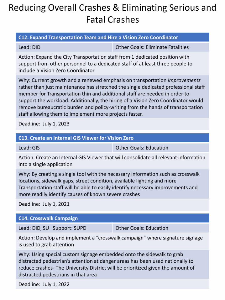
C12. Expand Transportation Team and Hire a Vision Zero Coordinator
Lead: DID Other Goals: Eliminate Fatalities
Action: Expand the City Transportation staff from 1 dedicated position with support from other personnel to a dedicated staff of at least three people to include a Vision Zero Coordinator
Why: Current growth and a renewed emphasis on transportation improvementsrather than just maintenance has stretched the single dedicated professional staff member for Transportation thin and additional staff are needed in order to support the workload. Additionally, the hiring of a Vision Zero Coordinator would remove bureaucratic burden and policy-writing from the hands of transportation staff allowing them to implement more projects faster.
Deadline: July 1, 2023
C13. Create an Internal GIS Viewer for Vision Zero
Lead: GIS Other Goals: Education
Action: Create an Internal GIS Viewer that will consolidate all relevant information into a single application
Why: By creating a single tool with the necessary information such as crosswalk locations, sidewalk gaps, street condition, available lighting and more Transportation staff will be able to easily identify necessary improvements and more readily identify causes of known severe crashes
Deadline: July 1, 2021
C14. Crosswalk Campaign
Lead: DID, SU Support: SUPD Other Goals: Education
Action: Develop and implement a “crosswalk campaign” where signature signage is used to grab attention
Why: Using special custom signage embedded onto the sidewalk to grab distracted pedestrian’s attention at danger areas has been used nationally to reduce crashes- The University District will be prioritized given the amount of distracted pedestrians in that area
Deadline: July 1, 2022
Reducing Overall Crashes & Eliminating Serious and Fatal Crashes
Reduction of Vehicles Miles Traveled (VMT) and
Providing New Alternatives
58
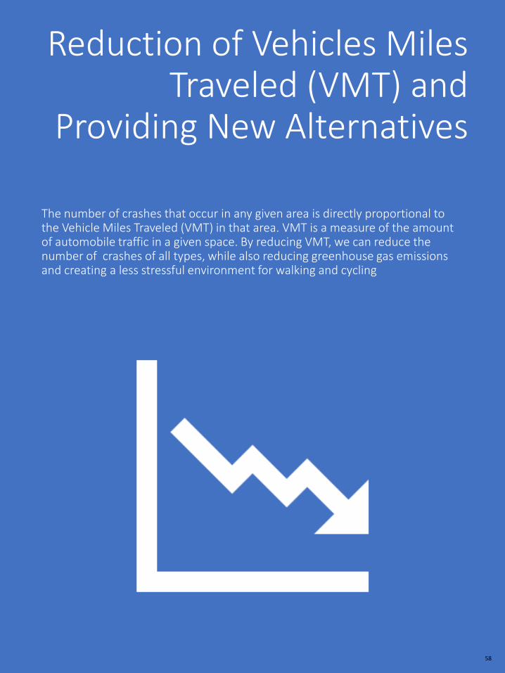
The number of crashes that occur in any given area is directly proportional to the Vehicle Miles Traveled (VMT) in that area. VMT is a measure of the amount of automobile traffic in a given space. By reducing VMT, we can reduce the number of crashes of all types, while also reducing greenhouse gas emissions and creating a less stressful environment for walking and cycling

59
D1. Execution of the Rail Trail and Urban Greenway Masterplans
Lead: DID Support: SU Other Goals: Reduce Crashes
Action: Continue the final design and implementation of the Bike Network, Rail Trail and Urban Greenway Masterplans
Why: The planned, Rail Trail and Urban Greenways will provide ample and safe routes for pedestrians and cyclists with the Rail Trail serving as a north-south backbone and the Urban Greenway creating the same core in an east-west configuration
Deadline: July 1, 2025
D2. Plan for Improvements to East-West Connectivity for Salisbury University
Lead: SU Support: DID, MDOT Other Goals: Eliminate Fatalities
Action: Improve non-motorists connectivity between the Main and East Campus facilities for SU; currently the two campuses are highly divided by US13 Business
Why: Student housing development on/around East Campus is increasing daily non-motorist activity along US13, meanwhile a major student housing development to the south of Main Campus is expected to increase pedestrian and cyclist activity along the Milford St corridor and US 13 crossing, especially on game days
Deadline: July 1, 2025
D3. Bike Share Implementation
Lead: Mayor’s Office Support: DID/SU Other Goals: Reduce Crashes
Action: Continue and execute the final contractual requirements for Bike Share Implementation
Why: The planned Bike Share system will provide short-term rentals of Bikes to residents across the City, when they need them, where they need them, freeing them from the constraints of a single mode for any individual trip
Deadline: July 1, 2021
Reduction of Vehicles Miles Traveled and Providing New Alternatives

60
D4. Execution of the Bicycle Network Masterplan
Lead: DID Support: SU/MDOT Other Goals: Reduce Crashes
Action: Continue the final design and implementation of the Bike Network
Why: The planned Bike Network will provide a safe, equitable transportation option to City residents. With the Network spreading radially from Downtown and Salisbury University, the network will combine with the Urban Greenway and Rail Trail every resident will have a bike facility of some type within ¼ mile of them
Deadline: Ongoing
D5. Increase in BPAC Presence and outreach
Lead: BPAC Support: DID Other Goals: Education
Action: BPAC will expand its outreach into the community by making the bike valet more visible and present at more events while also distributing educational materials and biking-related items to the public at events
Why: BPAC (Bicycle and Pedestrian Advisory Committee) is the City’s link to the public at events such as Third Friday, the National Folk Festival and more. They organize bike valet parking to encourage higher ridership and entire bike events that benefit all residents. Expanding their reach and message will help educate the public and encourage them to choose alternative travel modes
Deadline: July 1, 2021
Reduction of Vehicles Miles Traveled and Providing New Alternatives
D5. ADA Upgrades of Sidewalks
Lead: DID Other Goals:
Action: Increase the rate of installation of ADA compliant ramps, driveways and sidewalk widenings
Why: The City regularly updates ADA facilities in the sidewalk network. Increasing the frequency of such projects increasing the walkability of the network for all users and encourages higher use
Deadline: Ongoing
61
D7. Transit Expansion
Lead: Mayor’s Office Support: DID/SU Other Goals:
Action: Work with Partner Agencies to expand transit service and frequency
Why: Expansion of Mass Transit would provide enormous benefits to the public; fast, frequent and reliable service would be available for every resident. If coupled with MaaS real, measurable decreases in VMT are possible and additionally, improved service would benefit residents historically locked out of wider employment opportunities due to a lack of transportation
Deadline: July 1, 2025
D6. Mobility-as-a-Service Study
Lead: DID Support: GIS Other Goals:
Action: Study the potential implementation of a MaaS (mobility-as-a-Service) program within the City
Why: MaaS, which is just now emerging in the US but has been functional in Europe since 2014, provides the single greatest promise to reduce VMT across the City when coupled with transit expansion. If implemented, residents could sign up for a program where they pay monthly subscription fees to have access to a variety of transportation modes – car share, bike share, shuttle, mass transit –through a single app that also provide estimated arrival times by each mode and detail which option is the most convenient at that time
Deadline: July 1, 2023
Reduction of Vehicles Miles Traveled and Providing New Alternatives
D8. Salisbury Long Range Transportation Plan
Lead: DID Support: Other Goals: Reducing Crashes
Action: Develop a Long Range Transportation Improvement Plan (TIP)
Why: The S/W MPO already develops a regional TIP, however, developing a City specific TIP, utilizing the regional plan as the guide, will allow the City to get into greater detail and plan for specific measures up to 30 years out
Deadline: July 1, 2025

Education and Understanding
62
Despite the best efforts of staff to design and implement a safe transportation network, there will be occasions where individual choice comes into play. The long-term goal of Vision Zero is to establish a transportation network where mistakes made by individuals will not be fatal; in the short-term we can make a difference, save lives, and expand the message of Vision Zero through Education and Outreach

63
E1. Integration of Traffic Safety Modules into the Junior Fire Academy
Lead: SFD Support: DID Other Goals: Reduce Crashes
Action: Expand the curriculum of the successful Junior Fire Academy by adding traffic safety modules
Why: The Junior Fire Academy reaches children from across the City. By providing a little extra education in traffic safety the City may be able to preempt the occurrence of crashes; additionally, those participant are likely to spread the message to their friends, multiplying the effect
Deadline: July 1, 2023
E2. Expand Traffic Safety Education Program and Distribution
Lead: SFD Support: DID Other Goals: Reduce Crashes
Action: Work with DID to create educational materials that can be distributed at events where the SFD is already participating; Third Fridays, National Folk Festival, etc…and through the Department’s social media.
Why: By providing educational outreach regularly and consistently, the SFD can assist in helping educate the public on the risks associated with automobile travel.
Deadline: July 1, 2021
Education and Understanding
E3. Introduction of Traffic Safety Education into SPD Mentor Program
Lead: SPD Support: DID Other Goals: Reduce Crashes
Action: Integrate traffic safety education into SPD’s local school mentor program that reaches third and fourth graders.
Why: The SPD mentorship program already reaches young people in the neighborhoods that are most affected by the High Injury Network. By adding traffic safety into that program the City hopes to increase safety for the young users of our transportation network.
Deadline: July 1, 2021

64
E5. University Student Educational Campaign
Lead: SUPD Support: SU, DID Other Goals: Reduce Crashes
Action: Using City developed materials, distribute educational traffic safety materials and media to Students
Why: The University District contains several High-Injury Network Corridors and the nature of the University community lends itself well to outreach through SUPD at events and gathering areas, maximizing distribution
Deadline: July 1, 2022
E6. Develop Vision Zero Website and GIS App
Lead: DID Support: GIS Other Goals: Reduce Crashes
Action: Create a Vision Zero Webpage as part of the City’s website giving residents the latest news and information on progress. The page will be coupled with a GIS based app displaying the high-risk areas and should allow public participation/reporting
Why: Transparency is vital to Vision Zero and the web page will allow Citizen participation/contributions of data and give residents the idea of how the schedule is progressing
Deadline: July 1, 2021
Education and UnderstandingE4. Neighborhood Walks
Lead: HCDD Support: DID, SFD, SPD, FieldOps
Other Goals: Reduce Crashes
Action: Adding the distribution of Vision Zero materials to Neighborhood Walks, increase participation of transportation staff in the walks and develop a method for cataloguing the information
Why: HCDD regularly conducts neighborhood walks through the City where many of comments received revolve around traffic safety. It is an existing, established way to reach residents and can be expanded easily to contribute to the City’s Vision Zero efforts
Deadline: Ongoing

In Closing
Achieving our Mission, the end of fatal and serious injury causing crashes by 2030, is ambitious. It will require the focus and effort of not only the City and its partners, but our residents as well. We must treat all users of our transportation network as equals. Everyone must walk, bike and drive as if not only your neighbor’s lives depend upon it, but your own as well. Quite frankly, it does.
Our community has the tools and abilities to end these tragedies; now is the time to do so.
Together, we can eliminate Fatal and Serious Crashes by 2030.
65
References
Agencies/Groups
• Vision Zero Network-www.visionzeronetwork.org
• US Department of Transportation-www.transportation.gov
• Federal Highway Administration-highways.dot.gov
• National Highway Traffic Safety Administration – www.nhtsa.gov
• Maryland Dept. of Transportation – mdot.maryland.gov
• MDOT – State Highway Administration –roads.maryland.gov
• MDOT – MVA, Maryland Highway Safety Office -http://www.mva.maryland.gov/safety/mhso/index.htm
DATA
• All City Specific Data utilized in the formation of this plan was taken from data sets gathered at crash scenes and aggregated through various State office and programs. All agencies involved took every step necessary to validate data for accuracy.
• Articles
Curbed, “140 countries pledged to eliminate traffic deaths. The U.S. did not” by Alissa Walker https://www.curbed.com/2020/2/25/21150851/stockholm-declaration-road-safety-vision-zero
Blincoe, L. J., Miller, T. R., Zaloshnja, E., & Lawrence, B. A. (2015, May). The economic and societal impact of motor vehicle crashes, 2010. (Revised) (Report No. DOT HS 812 013). Washington, DC: National Highway Traffic Safety Administration
66

67