Embed Size (px)
Citation preview
TN33 0EA
VISUAL IMPACTPROVISION
Peak District National Park
Eastern Section
Options Appraisal Study
August 2015

This report has been prepared by Gillespies on behalf of National Grid. Detailed engineering and
technical information was provided by National Grid. Stakeholder engagement inputs were provided by
Camargue. We are also grateful to the Peak District National Park Authority, Barnsley Metropolitan
Borough Council and the stakeholder reference group for providing background information.
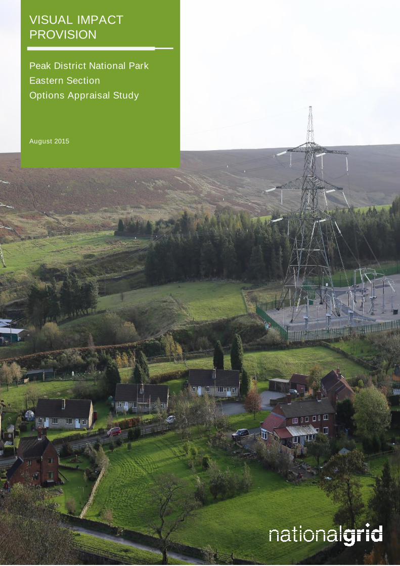
Front Cover: 400kV Sealing End Compound at Dunford Bridge

Contents
1 Introduction 1
Visual Impact Provision 1
The Peak District National Park (East) Project 2
2 Methodology 7
Environmental Statement 7
3 Study Area and Baseline 9
Route History 9
Study Area 9
Environmental Baseline 11
Socio-Economic Baseline 17
4 Stakeholder Engagement 20
Introduction 20
Stakeholder Meeting 20
Engagement Events 21
5 Potential Mitigation Solutions 26
Introduction 26
Option 1: Alternative Pylon Design 26
Option 2: Overhead Line on Alternative Route Alignment 28
Option 3: Underground Cable – Direct Burial/ Cable Troughs 29
6 Appraisal of Preferred Options and Conclusion 33
Option 3: Underground Cable – Direct Burial/ Cable Troughs 33
Overall Conclusion 35
Appendices
Appendix 1: Summary of Potential Primary Consenting Requirements 36
Tables
Table 1.1: Twelve Shortlisted Sections of Overhead Line 1
Table 2.1: Appraisal Topics 7
Figures
Figure 1.1 Subsection 4ZO.2 within Peak District National Park 3
Figure 1.2 View of sealing end compound at Dunford Bridge 6
Figure 3.1 Study Area 10
Figure 3.2 Landscape character 12
Figure 3.13 Ecology 14

Figure 3.4 Historic Environment 16
Figure 3.5 Access & Recreation 19
Figure 5.1 Alternative pylon designs 27
Figure 5.2 Example T-pylon (artist’s impression) 28
Figure 5.3 Example low-height pylon 28
Figure 5.4 Typical underground cable construction swathe drawing 29
Figure 5.5 Diagram of a typical sealing end compound 30
Figure 5.6 An operational sealing end compound 30
Figure 5.7 Potential Direct Burial Routes 32
Peak District National Park (East): Visual Impact Provision
Draft Options Appraisal Study
1 August 2015
1 Introduction
Visual Impact Provision
1.1 Ofgem and National Grid have agreed a new set of price controls and incentives for the period
from April 2013 to March 2021. This includes a provision of £500 million for electricity
transmission owners to mitigate the visual impact of existing electricity infrastructure in nationally
protected landscapes in Great Britain. For National Grid, which is the transmission owner in
England and Wales, this means considering the effects of existing infrastructure on the visual
amenity and landscapes of National Parks and Areas of Outstanding Natural Beauty (AONBs).
National Grid have referred to this as the Visual Impact Provision (VIP).
1.2 In 2012-13 National Grid prepared a Visual Impact Provision policy setting out how the fund
would be used and how stakeholders would be engaged in identifying opportunities for
maximising benefits from it. After a public consultation on the draft between July and September
2013 the policy statement was presented to Ofgem for review. The policy statement made it
clear that National Grid’s objective:
“is to achieve the maximum enhancement to the landscape from the available funds whilst
ensuring that no significant adverse impacts arise as a result”.
1.3 The policy document included a set of guiding principles and a commitment to the creation of a
Stakeholder Advisory Group consisting of stakeholders with national remits for England and
Wales, and ways of engaging other stakeholders. National Grid is committed to using the VIP in a
collaborative and transparent way.
1.4 In 2014 National Grid commissioned a landscape and visual impact assessment project to provide
evidence, both to itself and its Stakeholder Advisory Group about the relative impacts of the
different transmission lines and to inform the decision making process. The purpose of the
landscape and visual impact assessment project was to identify those sections of electricity
transmission lines within in England and Wales that have the most important impacts on the
landscape and visual amenity of these designated landscapes. The emphasis was on undertaking
a comparative assessment of the landscape and visual impacts of the sections of transmission
lines that lie within the designated areas in order to identify a possible shortlist of candidate
schemes for consideration by the Stakeholder Advisory Group and to decide which sections should
be taken forward for more detailed technical assessment.
1.5 The landscape and visual impact assessment Technical Report was published in October 2014,
and included a suggested shortlist of twelve subsections of overhead line which emerged as
having the highest level of combined landscape and visual impacts, and therefore merited further
investigation. The twelve subsections (listed in order of combined landscape and visual impact
score and by alphabetical order where scores are the same) are presented in Table 1.1:
Table 1.1: Twelve Shortlisted Sections of Overhead Line
Designated Area Subsection
Tamar Valley AONB YF.1
Peak District NP 4ZO.4
Dorset AONB 4YA.7
Peak District NP 4ZO.2
Peak District NP 4ZO.3
Peak District National Park (East): Visual Impact Provision
Draft Options Appraisal Study
2 August 2015
Designated Area Subsection
Brecon Beacons NP 4YU.3
North Wessex Downs AONB YYM.4
Snowdonia NP 4ZC.1
Dorset AONB 4VN.2
Dorset AONB 4YA.5
High Weald AONB 4ZJ.1
New Forest NP 4YB.2
1.6 The Stakeholder Advisory Group accepted all 12 of these subsections as worthy of progression to
the next stage of the work. The Tamar Valley AONB was used to pilot an approach to the
appraisal of the different mitigation options that might be feasible. The approach was then rolled
out to all of the shortlisted subsections of line. The aim of this work was to define one or at most
two preferred options for mitigation in the form of ‘mitigation projects’ for each shortlisted
subsection of line.
1.7 Since undergrounding is likely to emerge in many cases as a preferred approach, a prime
consideration in defining the projects in each case was the potential location of sealing end
compounds (SECs) where the transition from overhead to underground lines takes place. In
identifying suitable locations it has often been the case that the most suitable place for the SECs
will lie outside the extent of the line subsection on the shortlist. This means that the projects may
include an adjacent part of a line subsection not assessed as having the highest level of landscape
and visual impact but which must be included for practical purposes.
1.8 Conversely, in some cases not all of the shortlisted subsection is included within the study area.
Reasons for this, where applicable, are highlighted in the individual reports but include; changes
as a result of subsequent stakeholder discussions, and further appraisal from site visits (the
divisions between subsections were originally determined based on changes in landscape
character, as presented in published documents, prior to field surveys being carried out, rather
than on the basis of scale of impact).
1.9 Following approval from the Stakeholder Advisory Group, National Grid, is also developing an
initiative which will use part of the £500 million allocation for smaller localised visual improvement
projects which can be accessed by all AONBs and National Parks with existing National Grid
electricity infrastructure. This landscape enhancement initiative (LEI) has an ambition to provide
up to £24 million over six years (2015 to March 2021) with the aim of reducing the visual impact
of National Grid’s existing infrastructure and improve the related visual quality of the landscape.
The Peak District National Park (East) Project
1.10 Following the acceptance of the findings of the Technical Report by the Stakeholder Advisory
Group, National Grid decided to progress all of the other 11 sections to the same stage. The
identified section of line runs from a SEC near to the eastern entrance of the Woodhead Tunnel at
Dunford Bridge eastwards along the Upper Don River before it crosses the National Park
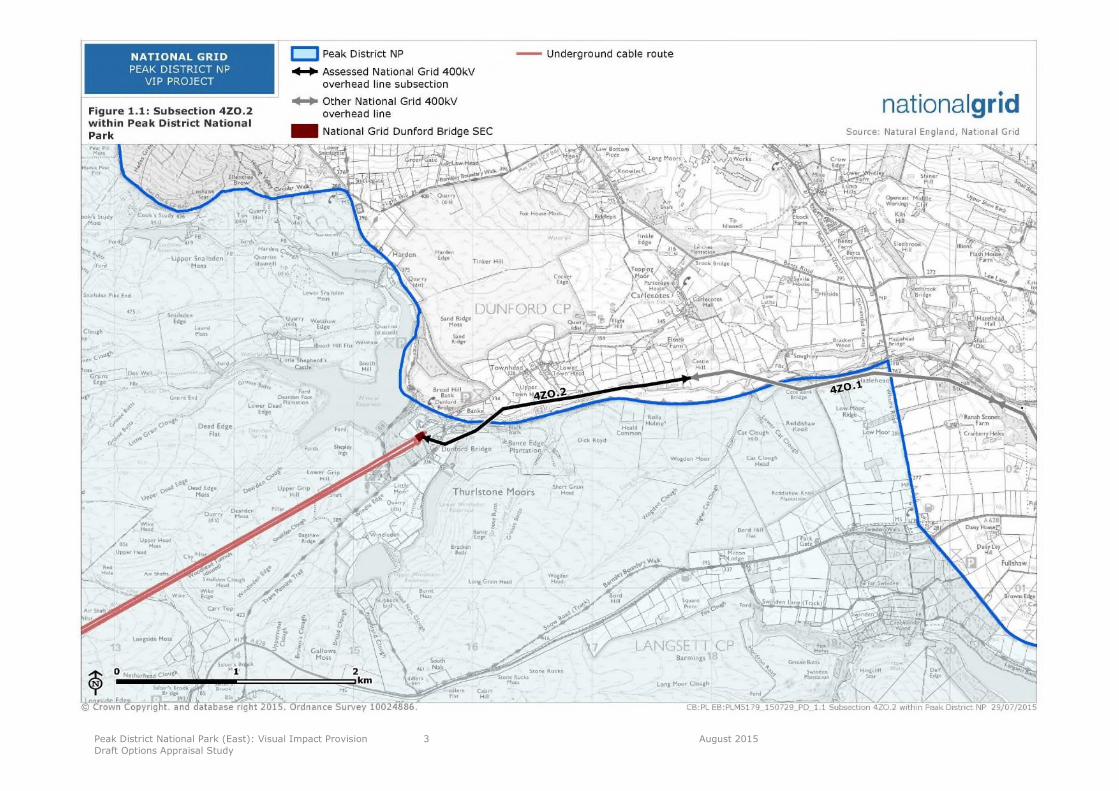
boundary. This section of line is 2.37km in length, and is shown in the context of the National
Park in Figure 1.1.
Peak District National Park (East): Visual Impact Provision
Draft Options Appraisal Study
3 August 2015
Figure 1.1 Subsection 4ZO.2 within Peak District National Park

Peak District National Park (East): Visual Impact Provision
Draft Options Appraisal Study
4 August 2015
Peak District National Park
1.11 In 1951 the Peak District was the first area in England and Wales to be designated as a National
Park. The aims and purposes of National Parks are laid out by law as follows:
“The 1949 National Parks and Access to the Countryside Act, was a law made by parliament that
set out what our National Parks would be like. The Environment Act 1995 revised the original
legislation and set out two statutory purposes for National Parks in England and Wales:
1 Conserve and enhance the natural beauty, wildlife and cultural heritage
2 Promote opportunities for the understanding and enjoyment of the special qualities of
National Parks by the Public
When National Parks carry out these purposes they also have the duty to:
Seek to foster the economic and social well being of local communities within the National
Parks”1
1.12 Special Qualities of the National Park are defined in the Peak District National Park Management
Plan as follows:
Natural beauty, natural heritage, landscape character and landscapes.
Sense of wildness and remoteness.
Clean air, earth and water.
Importance of wildlife and the area’s unique biodiversity.
Thousands of years of human influence which can be traced through the landscape.
Distinctive character of hamlets, villages and towns.
Trees, woodlands, hedgerows, stone walls, field barns and other landscape features.
Significant geological features.
Wealth of historic buildings, parks and gardens.
Opportunities to experience tranquillity and quiet enjoyment.
Easy access for visitors and surrounding urban areas.
Opportunities to experience dark night skies.
Vibrancy and a sense of community.
Cultural heritage of history, archaeology, customs, traditions, legends, arts, and literary
associations.
Opportunities for outdoor recreation and adventure.
Environmentally friendly methods of farming and working the land.
Craft and cottage industries.
Opportunities to improve physical and emotional well-being.
Special values attached to the national park by surrounding urban communities.
The flow of landscape character across and beyond the national park boundary.2
1http://www.nationalparks.gov.uk/learningabout/whatisanationalpark/aimsandpurposesofnationalparks
2Peak District National Park Management Plan 2012-2017 http://www.peakdistrict.gov.uk/microsites/npmp/about-the-national-
park/national-park-special-qualilties.
Peak District National Park (East): Visual Impact Provision
Draft Options Appraisal Study
5 August 2015
1.13 The focus of the VIP project is on the mitigation of landscape and visual impacts, and the
assessment of these impacts is set out in the landscape and visual impact assessment Technical
Report3. The summary sections relating to the 4ZO.2 subsection are reproduced below.
1.14 Engagement events (‘Stakeholder Reference Group’ workshop and public ‘drop in’) were
undertaken in April 2015 (see Section 4). The western part of section 4ZO.2 was identified as
having the greatest visual impacts whilst the line to the east along the Upper Don Valley had
fewer impacts on visual amenity in terms of receptor groups and numbers; with views from the
Trans Pennine Trail often being screened by vegetation.
1.15 A number of potential solutions may help mitigate the landscape and visual impact of the 400kV
overhead (transmission) line (400kV OHL) on the National Park. The purpose of this Options
Appraisal Study is to identify these and determine which, if any, will deliver the necessary
mitigation without giving rise to adverse impacts that would be greater than those being
mitigated.
3Visual Impact Provision, Landscape and Visual Impact Assessment of existing electricity transmission infrastructure in nationally
protected landscape in England and Wales. National Grid, Oct 2014. http://www2.nationalgrid.com/UK/In-your-area/Visual-Impact-Provision/Downloads/
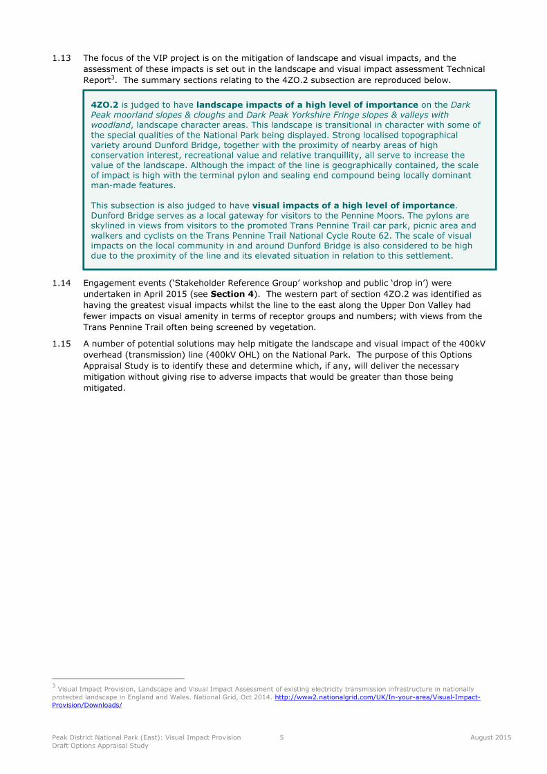
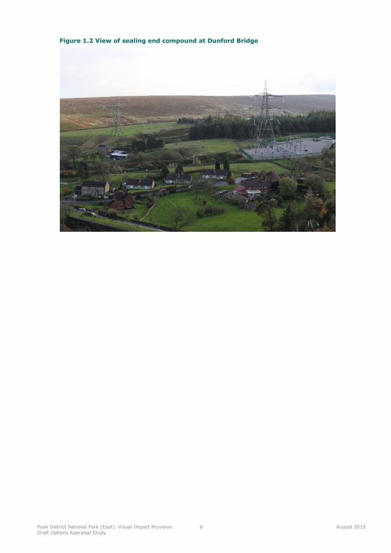
4ZO.2 is judged to have landscape impacts of a high level of importance on the DarkPeak moorland slopes & cloughs and Dark Peak Yorkshire Fringe slopes & valleys withwoodland, landscape character areas. This landscape is transitional in character with some ofthe special qualities of the National Park being displayed. Strong localised topographicalvariety around Dunford Bridge, together with the proximity of nearby areas of highconservation interest, recreational value and relative tranquillity, all serve to increase thevalue of the landscape. Although the impact of the line is geographically contained, the scaleof impact is high with the terminal pylon and sealing end compound being locally dominantman-made features.
This subsection is also judged to have visual impacts of a high level of importance.Dunford Bridge serves as a local gateway for visitors to the Pennine Moors. The pylons areskylined in views from visitors to the promoted Trans Pennine Trail car park, picnic area andwalkers and cyclists on the Trans Pennine Trail National Cycle Route 62. The scale of visualimpacts on the local community in and around Dunford Bridge is also considered to be highdue to the proximity of the line and its elevated situation in relation to this settlement.
Peak District National Park (East): Visual Impact Provision
Draft Options Appraisal Study
6 August 2015
Figure 1.2 View of sealing end compound at Dunford Bridge
Peak District National Park (East): Visual Impact Provision
Draft Options Appraisal Study
7 August 2015
2 Methodology
2.1 This study identifies potentially feasible ways of mitigating the identified impacts of the 4ZO.2
route on the Peak District National Park. The appraisal of the identified options follows the
general approach set out in National Grid’s document Our Approach to Options Appraisal (2012).
It covers the three main topic areas (Technical, Environmental and Socio-Economic) which can be
broken down into sub-topics as identified in Table 2.1 below. Sub-topics are only considered
where they may influence the choice of option.
Table 2.1: Appraisal Topics
Technical Environmental Socio-economic
Technical complexity Landscape and visual Local economic impact
Construction/project delivery
issues
Ecology Aviation and defence
Suitability of technology Historic environment Traffic and transport
Network capacity Water
Network efficiencies/ benefits Local air quality
Noise and vibration
Soils and geology
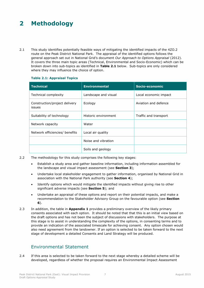
2.2 The methodology for this study comprises the following key stages:
Establish a study area and gather baseline information, including information assembled for
the landscape and visual impact assessment (see Section 3);
Undertake local stakeholder engagement to gather information, organised by National Grid in
association with the National Park authority (see Section 4);
Identify options which would mitigate the identified impacts without giving rise to other
significant adverse impacts (see Section 5); and
Undertake an appraisal of these options and report on their potential impacts, and make a
recommendation to the Stakeholder Advisory Group on the favourable option (see Section
6).
2.3 In addition, the table in Appendix 1 provides a preliminary overview of the likely primary
consents associated with each option. It should be noted that that this is an initial view based on
the draft options and has not been the subject of discussions with stakeholders. The purpose at
this stage is to assist in understanding the complexity of the options, in consenting terms and to
provide an indication of the associated timescale for achieving consent. Any option chosen would
also need agreement from the landowner. If an option is selected to be taken forward to the next
stage of development a detailed Consents and Land Strategy will be produced.
Environmental Statement
2.4 If this area is selected to be taken forward to the next stage whereby a detailed scheme will be
developed, regardless of whether the proposal requires an Environmental Impact Assessment

Peak District National Park (East): Visual Impact Provision
Draft Options Appraisal Study
8 August 2015
under the terms of the Town and Country Planning (Environmental Impact Assessment)
Regulations, National Grid would undertake an Environmental Impact Assessment and produce a
detailed Environmental Statement to accompany the planning application.
Peak District National Park (East): Visual Impact Provision
Draft Options Appraisal Study
9 August 2015
3 Study Area and Baseline
Route History
3.1 The 4ZO 400kV overhead line connects Stalybridge 400kV substation, Stocksbridge 400kV and
Thorpe Marsh 400kV substations. The line was constructed between 1966 and 1967 with L6
standard lattice pylon design and strung with twin and quad conductor bundles along various
sections. There is a high voltage cable section installed in the Woodhead Tunnel between Dunford
Bridge and Woodhead connecting the eastern and western section of the overhead line.
3.2 The substations at Stalybridge serve as a connection point for the local distribution network for
the Manchester area. Any potential solution would be designed to meet the potential capability of
the existing infrastructure.
Study Area
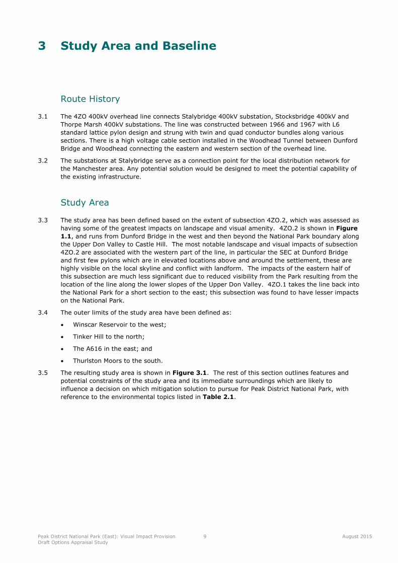
3.3 The study area has been defined based on the extent of subsection 4ZO.2, which was assessed as
having some of the greatest impacts on landscape and visual amenity. 4ZO.2 is shown in Figure
1.1, and runs from Dunford Bridge in the west and then beyond the National Park boundary along
the Upper Don Valley to Castle Hill. The most notable landscape and visual impacts of subsection
4ZO.2 are associated with the western part of the line, in particular the SEC at Dunford Bridge
and first few pylons which are in elevated locations above and around the settlement, these are
highly visible on the local skyline and conflict with landform. The impacts of the eastern half of
this subsection are much less significant due to reduced visibility from the Park resulting from the
location of the line along the lower slopes of the Upper Don Valley. 4ZO.1 takes the line back into
the National Park for a short section to the east; this subsection was found to have lesser impacts
on the National Park.
3.4 The outer limits of the study area have been defined as:
Winscar Reservoir to the west;
Tinker Hill to the north;
The A616 in the east; and
Thurlston Moors to the south.
3.5 The resulting study area is shown in Figure 3.1. The rest of this section outlines features and
potential constraints of the study area and its immediate surroundings which are likely to
influence a decision on which mitigation solution to pursue for Peak District National Park, with
reference to the environmental topics listed in Table 2.1.
Peak District National Park (East): Visual Impact Provision
Draft Options Appraisal Study
10 August 2015
Figure 3.1 Study Area
Peak District National Park (East): Visual Impact Provision
Draft Options Appraisal Study
11 August 2015
Environmental Baseline
Landscape and Visual
3.6 Landscape and visual impacts are defined in the third edition of Guidelines for Landscape and
Visual Impact Assessment (GLVIA3), as follows:
Landscape impacts means effects on the landscape as a resource in its own right; and
Visual impacts means effects on specific views and on the general visual amenity experienced
by people.4
3.7 The 400kV OHL runs from a SEC near to the eastern entrance of the Woodhead Tunnel at Dunford
Bridge. The line runs eastwards around Dunford Bridge before leaving the National Park
boundary. The SEC, terminal pylon subsequent three angle pylons to the east are particularly
prominent on the local skyline and lie close to residential properties in Dunford Bridge.
Landscape Character
3.8 This section presents an overview of the landscape baseline including landscape character, current
landscape condition and any designation attached to the landscape.
3.9 Dunford Bridge SEC is located immediately south west of the small hamlet of Dunford Bridge at
the eastern end of the Woodhead Tunnel. The landscape here is characterised by reservoirs,
moorland and pastoral river valleys. The line diverts slightly to the south from the SEC (around
the small settlement of Dunford Bridge) and exits the National Park before continuing along the
boundary of the Park following the lower slopes of the Upper Don Valley to the east.
3.10 The line passes through areas characterised in the Peak District National Park Landscape Strategy
and Action Plan 2009 – 2019 as landscape character types (LCT). Within the Park the line runs
along the boundary of Dark Peak Moorland Slopes & Cloughs and Dark Peak Yorkshire Fringe
Slopes & Valleys with Woodland LCTs. Outside the Park the line lies fully within Dark Peak
Yorkshire Fringe Slopes & Valleys with Woodland LCT. LCTs are illustrated on Figure 3.2.
3.11 The landscape of the study area consists of a relatively small-scale river valley with steeply
sloping and undulating valley sides punctuated by incised streams and flushes. To the north and
south, steeper slopes and cloughs rise to open moorland on the high plateaux above. Land cover
within the valley is generally small-scale pastoral fields enclosed by dry stone walls with
intermittent trees. Deciduous tree cover is most notably associated with the Upper Don Valley
and a disused railway line (now the route of the Trans Pennine Trail and National Cycle Route 62).
Medium sized blocks of coniferous plantation lie to the east near to Winscar Reservoir. There are
also small isolated settlements (primarily Dunford Bridge), as well as dispersed farmsteads and
properties. The enclosed and intimate nature of the valley creates a sense of tranquillity. This
tranquillity is interrupted by the presence of pylons.
Visual Amenity
3.12 This section identifies the visual amenity and availability of views as currently experienced by
people (visual receptors). Visual receptors include local communities, residents in scattered
houses, visitors to the area, recreational users including users of the Public Rights of Way
network, motorists on the local road network and people working within the area.
3.13 General visibility within the valley is restricted to views along the valley corridor (west - east) and
across the valley (north - south). Views are attractive where the character is more open and
especially from elevated vantage points. Views are often foreshortened and visibility is further
restricted by undulating landform and trees and blocks of woodland within and around the valley.
4Landscape Institute and Institute of Environmental Management and Assessment (2013) Guidelines for Landscape and Visual Impact
Assessment. 3rd Edition. Routledge. Paragraph 2.21.
Peak District National Park (East): Visual Impact Provision
Draft Options Appraisal Study
12 August 2015
Figure 3.2 Landscape character

Peak District National Park (East): Visual Impact Provision
Draft Options Appraisal Study
13 August 2015
3.14 People within the National Park who experience these views include residents of Dunford Bridge
as well as people living in the scattered farmsteads and properties within the area, many of which
are outside the Park. The presence of pylons also affects the experience of visitors who park at
Dunford Bridge and come to walk and enjoy the scenery or participate in watersports at Winscar
Reservoir. People using the local lanes and users of the Trans Pennine Trail (part of European
Long Distance Footpath E8), National Cycle Route 62, National Cycle Route 68, Kinder Loop long
distance bridleway, Barnsley Boundary Walk and the Upper Don Valley Trail often have clear
foreground views of pylons.
Ecology
3.15 This section of 400kV OHL does not cross any international or national designations.
3.16 The moorland to the far west of the study area is designated at an international level as South
Pennine Moors Special Area of Conservation (SAC) and Peak District Moors (South Pennine Moors
Phase 1) Special Protection Area (SPA). At a national level it is designated as the Dark Peak Site
of Special Scientific Interest (SSSI). These designations are shown on Figure 3.3.
3.17 South Pennine Moors SAC has been designated for its extensive areas of European dry heaths,
blanket bogs and old sessile oak woods with holly (Ilex) and fern (Blechnum) species in the British
Isles and also northern Atlantic wet heaths with Erica tetralix and transition mires and quaking
bogs.5 These are all Annex I habitats which are protected under Council Directive 92/43/EEC
Habitats Directive, with the aim to maintain or restore natural habitats and wild species listed on
the Annexes to the Directive.
5South Pennine Moors SAC, JNCC. http://jncc.defra.gov.uk/protectedsites/sacselection/sac.asp?eucode=UK0030280
Peak District National Park (East): Visual Impact Provision
Draft Options Appraisal Study
14 August 2015
Figure 3.3 Ecology
Peak District National Park (East): Visual Impact Provision
Draft Options Appraisal Study
15 August 2015
3.18 Peak District Moors (South Pennine Moors Phase 1) SPA is designated because of its bird
populations of European importance which include merlin (Falco columbaris), golden plover
(Pluvialis apricaria) and short-eared owl (Asio flammeus).6
3.19 The Dark Peak SSSI is protected because it is an extensive tract of semi-natural upland
vegetation typical of and including the full range of moorland vegetation of the South Pennines.
Several vegetation types, plants and animals are at either the southern or northern limits of their
distribution in this country. The Dark Peak moorlands support the full range of breeding birds
found in the South Pennines, some of which are represented at their southern most viable English
locations and which are of great regional and national importance. Many physical features of the
Dark Peak are of geological interest7
3.20 The Upper Don Valley around Dunford Bridge is not recognised as being internationally or
nationally important in ecological terms but is of local importance for wildlife and habitats.
Wogden Foot is a Local Wildlife Site, is on the site of former railway sidings where limestone
ballast was dumped after closure of the Woodhead Line. It displays an unusual mix of acidic,
neutral and calcareous grassland habitats8 including lowland heath which is a UK BAP priority
habitat9. Over 86 plant species have been identified including the rare Jacob’s ladder, which is
normally found in in limestone dales, other notable species include wild mignonette and common
spotted orchid. To maintain species-richness, the site is managed by conservation grazing using
native breed sheep and cattle.
3.21 The undesignated parts of the study area comprise areas of moorland and pastoral farmland, with
dry stone walls and small areas of woodland along watercourses. Searches for protected species
data and ecological surveys will be undertaken to inform detailed routeing.
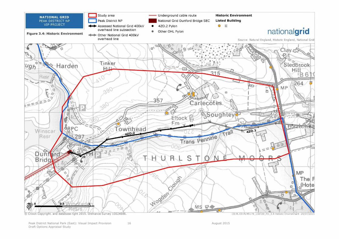
Historic Environment
3.22 There are no internationally or nationally designated features in the study area. There are
however several Grade II listed buildings along Brook Hill Lane to the north of the line (Brook Hill
Lane runs from Dunford Bridge to Carlecotes and beyond) and a Grade II listed barn at Softly
Farm to the north east. These listed buildings are shown on Figure 3.4. There is a high
possibility that unrecorded industrial archaeology exists under the old railway line and that
unrecorded prehistoric archaeology exists under historical field systems to the north of the Upper
Don River.
3.23 The Historic Environment Record (HER) may identify further historic features. This work is
ongoing and will be included in the final information submitted to the Stakeholder Advisory Group.
6Peak District Moors (South Pennine Moors Phase 1) SPZ Citation
http://publications.naturalengland.org.uk/publication/61458896681697287
http://www.sssi.naturalengland.org.uk/citation/citation_photo/1003028.pdf8
http://www.barnsleybiodiversity.org.uk/sites.html9
http://www.barnsleybiodiversity.org.uk/lowlandheath.html
Peak District National Park (East): Visual Impact Provision
Draft Options Appraisal Study
16 August 2015
Figure 3.4 Historic Environment
Peak District National Park (East): Visual Impact Provision
Draft Options Appraisal Study
17 August 2015
Water
3.24 The Environment Agency’s Flood Map shows several narrow zones along the Upper Don River
which have a ‘High’ risk of flooding; areas with a ‘Medium’ risk of flooding to the east of Windle
Edge road adjacent to Don View road in Dunford Bridge and immediately north of the river near
Upper Townhead Farm. Elsewhere along the river the risk of flooding is indicated as ’Low’.10
3.25 Several minor watercourses feed into the Upper Don River. Railway culverts still exist under the
Trans Pennine Trail including a culvert for the watercourse which flows to the Upper Don River
from Lower Windleden Reservoir.
3.26 More detailed assessment of water quality and potential impacts is likely to be required for
construction and operational activities as part of the supporting documentation to accompany a
planning application(s).
Soils and Geology
3.27 The bedrock underlying most of the area comprises Millstone Grit of the Rossendale Formation
(Mudstone and Siltstone), Marsden formation (Mudstone and Siltstone) and Huddersfield White
Rock (Sandstone). There are superficial deposits of alluvium (clay, silty) on the south side of the
Upper Don Valley and superficial deposits of peat on the moorland.
3.28 At Wogden Foot there is limestone railway ballast that was dumped on the site after the closure of
the railway line.
Other Environmental Issues
3.29 At this stage of the appraisal process it is considered that certain environmental topics, for
example local air quality, noise and vibration would not influence the choice of a preferred option
and hence have not been included. More detailed assessment of a wide range of topics (including
air quality, noise and vibration) is likely to be required for construction and operational activities
as part of the supporting documentation to accompany a planning application(s).
Socio-Economic Baseline
Local Economic Activity
3.30 Socio-economic activity is mainly restricted to farming activities with the land being used for
sheep and cattle grazing. Farmland around subsection 4ZO.2 is classified as low grade 4 or 511.
3.31 The Pennine Sailing Club is based at Winscar Reservoir and has a growing membership of some
200 sailors and windsurfers from the surrounding areas of Sheffield, Huddersfield, Barnsley and
Glossop.
3.32 Up until early 2000 there was one public house in Dunford Bridge, this has now closed down and
is to be converted into two dwellings.
Traffic and Transport
3.33 The road network immediately around Dunford Bridge is limited to lanes/ unclassified roads which
link the scattered settlements and individual farmsteads and properties; however, the A628 and
A616 main roads provide adequate road links to the west and east.
Access and Recreation
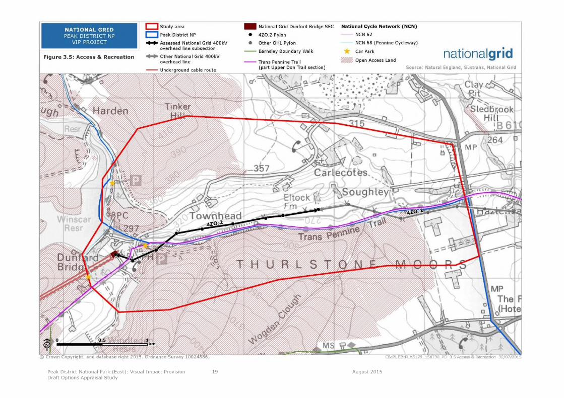
3.34 The Trans Pennine Trail and National Cycle Route 62 largely follow the route of the old railway line
and the Upper Don Valley Trail from west to east. The Trans Pennine Trail also forms part of
European Long Distance Footpath E8.
10http://watermaps.environment-
agency.gov.uk/wiyby/wiyby.aspx?topic=floodmap&scale=9&ep=map&layerGroups=default&lang=_e&y=63336&x=242219#x=415501&y=402537&scale=1111
http://publications.naturalengland.org.uk/publication/6172638548328448

Peak District National Park (East): Visual Impact Provision
Draft Options Appraisal Study
18 August 2015
3.35 National Cycle Route 68 (Pennine Cycleway) runs from north to south skirting around Winscar
Reservoir and along the same route as the Barnsley Boundary Walk.
3.36 There are relatively few Public Rights of Way in the area; however, there are vast tracts of Open
Access Land up on the moorlands.
3.37 There is a car park and picnic area next to the road bridge at Dunford Bridge and further car
parking and picnic areas to the east of Winscar Reservoir off Dunford Road and also to the south
west of the reservoir off Windle Edge.
3.38 As noted previously Winscar Reservoir is well used for recreational boating By Pennine Sailing club
3.39 Access and recreation features are shown on Figure 3.5.
Peak District National Park (East): Visual Impact Provision
Draft Options Appraisal Study
19 August 2015
Figure 3.5 Access & Recreation
Peak District National Park (East): Visual Impact Provision
Options Appraisal Study
20 February 2015
4 Stakeholder Engagement
Introduction
4.1 Having identified a shortlist of 12 subsections of line in eight designated areas using the
landscape assessment methodology, the Stakeholder Advisory Group asked National Grid to carry
out early stage engagement with stakeholders and the public at a local level.
4.2 The aim of this early engagement was to gather information and intelligence on the areas to
inform the options assessments and to gauge local attitudes and opinions on the work. It was also
felt that involving local groups and individuals at the outset would not only help to identify any
potential problems and challenges but also to give the local community a sense of ownership. It
should be a requirement of any scheme taken forward to major engineering work that it has the
support and involvement of local people.
4.3 It was also agreed at the Stakeholder Advisory Group that National Grid should work with the
Peak District National Park Authority to present a collaborative, inclusive partnership approach to
the local community.
Stakeholder Meeting
4.4 Following an independently facilitated workshop involving a broad range of stakeholders to
discuss the options for the shortlisted section of line to the west of the Woodhead Tunnel (held in
March 2015), it was agreed that it would be necessary to adopt a similar approach to stakeholder
engagement for the shortlisted section to the east of the Woodhead Tunnel as had been adopted
in the other locations. It was agreed therefore that:
Stakeholder engagement would take place as soon as practically possible.
The engagement event would take place on the same day with a workshop for selected,
relevant individuals / organisations followed by a drop in event for the public (afternoon and
evening).
This initial stakeholder engagement would inform the landscape and technical work.
The workshop would be a closed session, focused on a smaller group and technical in nature.
Attendees would comprise primarily key representatives from the National Park Authority
(NPA) and other key statutory bodies identified by the NPA and agreed with National Grid.
Personal invites would be issued to the workshop. Personal invites would also be issued to the
drop in sessions to selected groups / individuals (as advised by the NPA).
General invites would be sent to other relevant groups / local affected communities primarily
using the NPA’s’ networks / databases. National Grid would work with the NPA’s
communications officers to ensure that the message was delivered to relevant audiences
Drop in events would need to take place at a convenient location for members of the
community as advised by local stakeholders.
Peak District National Park (East): Visual Impact Provision
Options Appraisal Study
21 February 2015
Engagement Events
4.5 On the advice of local stakeholders, the events were held as follows. Both workshop and drop in
event took place on Thursday 30th April 2015. The workshop was held at The Core building in
Barnsley. The drop in event was held at The Parish Community Centre in Holmfirth, a venue close
to the community of Dunford Bridge.
4.6 The workshop ran from 10.00am until 12.30pm and was attended by nine representatives from
local stakeholders including Peak District NPA officers and representatives from Barnsley
Metropolitan Borough Council, Dunford Bridge Parish Council, Natural England and the Trans
Pennine Trail. Representatives from National Grid, Gillespies and Camargue were also in
attendance.
4.7 The drop in event ran from 2.00pm until 8.00pm and were staffed by representatives from
National Grid (VIP project team) along with Camargue. They were attended by a broad cross
section of the local community with a number of local residents from Dunford Bridge represented.
In total, 19 people attended the event.
4.8 The events were publicised as agreed with the NPA with direct invitations sent to the NPA’s
mailing list of key stakeholders. The event was also promoted via the NPA’s website, a piece on its
Facebook page and regular Tweets by its communications officer. National Grid worked closely
with the NPA’s communications officer and provided material for use in publicity proactively and
on demand.
4.9 A press release was produced and issued to local print and broadcast media. BBC Radio Leeds
interviewed National Grid’s press officer Jeanette Unsworth who explained the VIP process to the
listeners and promoted the drop in event in Holmfirth.
Stakeholder feedback
First Technical Workshop
4.10 The section of overhead line (east of Woodhead Tunnel) that scored as one of the highest in the
2014 appraisal was sub-section 4ZO.2 (2.37km long) which runs in an east – west direction
towards the north of the National Park.
The following key issues were discussed at the Technical Workshop:
4.11 Overview of the Area
There was general agreement among all stakeholders present that the SEC in Dunford Bridge
is visually intrusive and had a negative impact on the local community (particularly residents
of Dunford Bridge) and on the Trans Pennine Trail.
A number of stakeholders were keen to point out the potential for local regeneration that the
removal of the SEC and section of transmission line could have on the local community.
Dunford Bridge had recently seen its village pub close and the area in general was under-
utilised when compared to other nearby areas of the Peak Park.
It was pointed out that much hard work and effort had been put into landscaping the Trans
Pennine Trail by enthusiastic local volunteers.
4.12 Landscape and Visual
The SEC at Dunford Bridge is visually intrusive. When the SEC was originally proposed (pre-
VIP project), Dunford Bridge Parish Council requested that this line section was placed
underground (thereby removing the need for a SEC in Dunford Bridge) but it was deemed
uneconomical.
Stakeholders would like to see the line removed as far as Hazlehead but it was recognised
that the section of line that runs to Hazlehead was not on the shortlist and its consideration
could not be justified. A more likely end location for any mitigation work would be at Castle
Hill. Stakeholders would be happy with this.
Peak District National Park (East): Visual Impact Provision
Options Appraisal Study
22 February 2015
Although it was felt that there was no easy location for the SEC, it was felt that Castle Hill
might be a suitable location.
An alternative would be in the valley below Wogden Foot where trees would potentially be
able to screen the SEC. It would also be hidden from Carlecoats and there would be less
distance from the road in from the Trans Pennine Trail than Castle Hill – making maintenance
/ access easier.
The group felt that placing the cables underground or in cable troughs would provide the best
solution to mitigate the impact of the existing line. The best location for doing this was the
subject of much debate. Options for burying the cable under the Trans Pennine Trail (in a
mixture of cable troughs and direct bury) or in agricultural land to the north of the line (direct
bury) were considered to be the best options worthy of further investigation.
Concerns were also raised about the visual impact of any access road to the SEC and it was
agreed that this would need careful consideration.
4.13 Ecology / Environment
Wogden Foot is a local wildlife site managed by the South Yorkshire Wildlife Trust. It is
unusual because ballast that was dumped there has acted as limestone and created an
enclave with unique limestone flora within an area of largely gritstone.
Wogden Foot boasts a number of rare plants, wildflower meadows and orchids as well as two
types of bat colonies and two badger setts.
There is also believed to be a glow worm colony at Wogden Foot (only the second in south
Yorkshire). A survey will be undertaken into this during the summer.
Conservation volunteers have worked hard to establish wildflower meadows and other
features along this stretch of the Trans Pennine Trail.
Hazlehead is an important area for breeding waders.
Actions to prevent the ballast being washed on the Upper Don River near Wogden Foot has
effectively protected this stretch of the river – which is the only grade one water supply in
south Yorkshire. It may be possible to attract salmon to this stretch of the river and local
environmentalists are looking at this option currently.
Some stakeholders wondered whether it would be possible to improve the wetland
environment in the area as a result of the work.
Stakeholders were keen to understand what constitutes deep-rooted plants and requested
guidance from National Grid. Is heather considered deep rooted for example?
4.14 Archaeology
Stakeholders representing archaeological interests set out what they would like to see from
National Grid in the event of intrusive works taking place either along the Trans Pennine Trail
or in its vicinity. This would include desk-based research with walk overs and an evaluation of
the particular areas of interest.
It was stated that although the Trans Pennine Trail offers much from a cultural heritage
perspective there is likely to be little of interest in terms of archaeology.
There is however a high potential for archaeology in the agricultural land to the north of the
line particularly in relation to field systems, etc.

Peak District National Park (East): Visual Impact Provision
Options Appraisal Study
23 February 2015
It was requested that National Grid open up a dialogue with archaeologists from both the
South Yorkshire Archaeology Service and the Peak District National Park Authority.
If the option of burying in the agricultural land was taken, a fund would be required for
investigating the archaeology – especially the old field patterns – and for restoring them once
construction work was complete.
4.15 Land Ownership
The land for the Trans Pennine Trail (and a 30m/40m corridor around it is owned by Barnsley
Metropolitan Borough Council. Beyond that the land (both agricultural – to the north) and
moorland – to the south) is in private ownership.
It was agreed that there were probably around three landowners of the agricultural land to
the north and west.
4.16 Tourism
Stakeholders were in unanimous agreement that the removal of the shortlisted line could
have a major impact on the regeneration of the area and in generating tourism in the
Dunford Bridge area.
Currently the village is blighted by the SEC. It is also the gateway to the National Park and
more could be made of this if the line and SEC were removed.
Although the pub has closed, it was felt that more could be made of Dunford Bridge’s
gateway to the National Park status and that there would be scope for cycle hire and / or a
cafe.
Currently the Dunford Bridge car park is severely under-used. On busy days, the car parks at
Langsett and Crowden are full to overflowing whereas there are few cars at Dunford Bridge.
This could change and the removal of the line would be the catalyst for this change.
Nearby sailing at Winscar also has the potential to bring economic growth into the area.
Dunford Bridge is also crossed by a number of key cycle routes including the West Yorkshire
Cycle route which is designed to get people from Sheffield out into the National Park.
The local authority and parish council were extremely positive about the potential positive
impacts on tourism and the local economy of removing the SEC and shortlisted line. They
reported that there was also significant local support for this.
4.17 Public Rights of Way and Access
Clearly if the Trans Pennine Trail was used as the location to bury the line in cable troughs,
there would be significant disruption to the route and an alternative would need to be found.
The interests of all user groups – walkers, cyclists and horse riders – will need to be taken
into consideration.
Rights of Way officers from Barnsley MBC identified an alternative route (marked on an OS
map) and this was given to the National Grid project team. Although not much longer in
distance, the route runs to the south of the existing trail and work would be needed to make
good the path particularly in some very wet areas. The temporary diversion would also
involve potentially three crossings of the A628 which would have safety issues particularly for
horse riders.
The footpath at Town Head Road needs upgrading. It is currently too difficult for horses.
Peak District National Park (East): Visual Impact Provision
Options Appraisal Study
24 February 2015
There have been complaints from horse riders that there is insufficient grass on the Trans
Pennine Trail. However, some stakeholders felt that horses were damaging the trail and that
proper provision needs to be made on the Trail for horse riders.
4.18 Potential Solutions / Construction Issues
Cutting a 9m swathe through sections of the Trans Pennine Trail might prove difficult due to
the narrowness of the trail and the steep nature of the valley on either side.
The SEC would require permanent access for maintenance while the access for any horizontal
directional drilling under the Upper Don River (if required) would only need to be temporary.
Vehicle access may be challenging – both in construction and maintenance of the SEC – as
the valley sides are steep when off the Trans Pennine Trail. An access road to the Trail was
built to enable resurfacing for the Tour de France in 2014. This may be an option but it was
not designed for heavy construction traffic.
Culverts would need to be checked and potentially replaced.
Underground cable is low maintenance and people are unlikely to drill into them.
Stakeholders felt it would be even less likely if the cables were in troughs under the Trans
Pennine Trail.
Cable troughs are air cooled and only a limited amount of material can be placed on top.
There is a possibility of growing grass on top of a cable trough but it is limited.
Stakeholders asked National Grid to investigate alternative coverings / materials for the cable
troughs. National Grid confirmed that it would not be possible to stack the cables in the
troughs as this would create hot spots.
Troughs are very near the surface to enable the cable to be air cooled (and therefore closer
together than in a direct bury situation).
If cable troughing along the Trans Pennine Trail, it would not be possible to bring HGVs along
the top road. They would need to come along the valley from Town Head.
Given the comparative ease of restoring agricultural land after direct burial, stakeholders
were keen that National Grid investigate the possibility of burying the cable in agricultural
land to the north of the Trail as well as in cable troughs under the Trans Pennine Trail.
Feedback from the Drop-in Event
4.19 Eight feedback forms were completed at the Peak District East event. Comments are summarised
below:
The local residents were interested in the VIP project and spent time discussing the project
with the members of the VIP Team.
Feedback received was predominantly from people living around the SEC at Dunford Bridge
and they were generally supportive of the project.
Over half of the comments on the forms were positive about the removal of overhead line to
help visually improve the landscape. It was felt that the disruption to remove the pylons
would be a short term inconvenience as it would ensure the area benefitted in the longer
term.
Tourism was an important issue for two residents and they voiced their support for the
removal of the pylons, stating that it would encourage more people to visit the area
Peak District National Park (East): Visual Impact Provision
Options Appraisal Study
25 February 2015
particularly to walk and cycle. Dunford Bridge does not attract the same level of tourism
compared to other higher profile areas within the National Park.
Referring to the SEC in Dunford Bridge as an “eyesore”, one resident was supportive of
undergrounding the cables, especially over other options such as lower height pylons.
One local landowner gave his support towards the project but shared his experience of
working with National Grid on another project in the area. At the event, the project team
talked to him and heard about his concerns.
Another resident was keen to learn more about the proposals as he had reservations about
the impact of the major engineering works on his daily life.
4.20 According to one resident, the pylons make a constant humming sound and their removal would
be welcomed to restore peace and tranquillity to the area.
Second Technical Workshop
4.21 A second meeting of technical stakeholders took place at The Core in Barnsley on 12 August
2015. Prior to the meeting each attendee was sent a copy of the Options Appraisal report. The
aim of the session was to obtain their feedback on the report and to provide attendees with a
forum in which they could raise any issues before the report is formally presented to the project’s
Stakeholder Advisory Group in September 2015.
Attendees were asked by National Grid to highlight any issues or inaccuracies in the report.
The meeting discussed the options for the section of line, 4ZO.2 and the following key points:
4.22 Transport during construction and access to the SEC during operations was a major consideration
for the SRG.
Careful consideration will need to be given for the location of access roads both during
construction and operation. The sides of the valley are steep sided.
If access is along the Trans Pennine Trail (TPT) then a large section of the trail will need to be
closed during construction and alternative routes identified and agreed. Approval from Highways
England for crossings on the A616 and associated signage will need to be factored into the
programme and secured well in advance of the temporary diversion of the TPT.
4.23 The SRG requested that search area B is extended to the west to include Castle Hill. The SRG felt
that the SEC could be accommodated better in search area B provided Castle Hill was included.
This was balanced however by the narrow width of the TPT in this section and the likely need to
take land from Wogden Foot nature reserve.
4.24 The SRG commented that the report needs to state that Wogden Foot nature reserve would be
affected if option B is selected due to the narrow width of the TPT at this point.
4.25 The SRG requested that a section on public rights of way which states that an alternative for the
TPT suitable for all users must be provided before any construction work begins is included in
section 6.
4.26 The SRG welcomed the report and considered both options. Although it asked for the area of
search for option B to be extended to the west to include Castle Hill, the overall consensus was
the option A was preferred.
It was felt that this option removed the section of line where it had the greatest impact (including
the SEC at Dunford Bridge). It also had no impact on Wogden Foot nature reserve and means
that less of the TPT would need to be re-directed during construction.
Peak District National Park (East): Visual Impact Provision
Options Appraisal Study
26 February 2015
5 Potential Mitigation Solutions
Introduction
5.1 A number of alternative solutions exist which could mitigate the impact of the 400kV OHL on the
National Park. The following section discusses each of these in turn. All routes shown are entirely
indicative, and will be subject to detailed route design if shown to be feasible. Construction and
operational impacts have been included in the consideration of these potential solutions.
Decommissioning of the existing 400kV OHL has not been factored in at this appraisal stage as it
is unlikely to influence between the mitigation options. However, the following paragraph
outlines the envisaged decommissioning process of the redundant infrastructure once the new
connection is operational.
5.2 Decommissioning would involve many of the activities associated with the construction phase, for
example provision of access points and haul roads and associated traffic movements for the
removal of equipment. Upon removal much of the material would be taken for reuse or
recycling. Pylon fittings, such as dampers and spacers, would be removed from the conductors.
The conductors would be cut into manageable lengths or would be winched onto drums. Each
pylon may be dismantled by crane, with sections cut and lowered to the ground for further
dismantling and removal from site. If space is particularly restricted, the pylon can act as the
scaffold and be dismantled from the inside. Conversely, in large areas it may be possible to cut
the pylon at the base and then pull the pylon to the ground using a tractor and then cut into
sections. A decision as to whether pylon foundations would be left in the ground would be made
at such time in the future and would also take account of land owner wishes and environmental
issues.
5.3 For the mitigation options identified it may be necessary for the erection of temporary structures
whilst cable sealing end and / or overhead line works are undertaken. These temporary
structures would require new designated access routes, however, these access routes and
structures would be removed once the new connection becomes operational.
Option 1: Alternative Pylon Design
5.4 Under Option 1, the route of the current overhead line would be maintained, as shown in Figure
1.1, but alternative pylon designs would be deployed from the SEC to the area around Castle Hill.
This could include either of the following designs, which are illustrated in Figure 5.1, together
with a conventional lattice pylon, which is included for comparison purposes:
The new T-pylon design; or
Low height pylon design (L12/LH).
Peak District National Park (East): Visual Impact Provision
Options Appraisal Study
27 February 2015
Figure 5.1 Alternative pylon designs
5.5 The T-pylon design was introduced by National Grid following a competition, as it was considered
to be an attractive, innovative and simple design while still offering the required structural
performance. It is around 10m shorter than the typical lattice pylon. Operational T-pylons have
not yet been deployed in the UK, though prototypes have been erected. An artist’s impression of
a T-Pylon is shown in Figure 5.2.
5.6 Low-height pylons are variations on the lattice pylon design, which carry the conductors in a
different arrangement. They are around 10m shorter than the typical lattice pylon, though
significantly wider with more substantial cross-arms. An example is shown in Figure 5.3.
5.7 In order to maintain the current route alignment, the existing line would have to be temporarily
diverted during construction work. This temporary diversion would require the construction of a
new overhead line route which would in turn require consent.
5.8 Discussion of this option with the project team, together with the feedback from the stakeholder
engagement, indicates that this option would not sufficiently mitigate the landscape and visual
impacts of the line in, and adjacent to, the National Park. Although lower, these alternative
structures would still be highly visible in the landscape and would not negate the need for a SEC;
indeed it is the SEC which has some of the greatest impacts on visual receptors. The
development of alternative pylon designs was therefore considered not to offer sufficient
mitigation of the landscape and visual effects, particularly in relation to Dunford Bridge; hence
this option was not investigated further.
Peak District National Park (East): Visual Impact Provision
Options Appraisal Study
28 February 2015
Figure 5.2 Example T-pylon (artist’s impression)
Figure 5.3 Example low-height pylon
Option 2: Overhead Line on Alternative Route Alignment
5.9 Option 2 would involve re-routeing the 400kV OHL along an alternative alignment (either using
conventional lattice or alternative pylon design).
5.10 The greatest impact of 4ZO.2 is associated with the SEC and the first few pylons around Dunford
Bridge. An alternative route alignment would not remove the need for the SEC and would also
have to negotiate around Dunford Bridge. The likely landscape and visual effects on Dunford
Bridge would therefore remain significant due to the proximity of SEC and pylons (whether they
be standard or alternative design). Additionally, as the existing route is relativity straight, any re-

Peak District National Park (East): Visual Impact Provision
Options Appraisal Study
29 February 2015
routeing of the line would necessarily involve a net increase in the number of pylons, so is
therefore likely to have increased visual impact. Hence this option was not investigated further.
Option 3: Underground Cable – Direct Burial/ Cable Troughs
5.11 An underground cable connection would replace all or part of the 4ZO.2 subsection of overhead
line which would be removed following installation and commissioning of the cable.
5.12 Direct burial of an underground cable would require a construction corridor typically 30-50m wide
along the length of the cable route. This width is to accommodate the cable trenches, haul road,
storage areas for stripped topsoil and sub soil from the cable trench excavation and inclusion of
any temporary & permanent land drainage requirements. This is based on the assumption that
direct burial is using twelve cables to maintain circuit capacity. Following completion of the cable
installation, the ground would be returned to its previous use. Hedgerows and other field
boundaries would be reinstated. Trees felled would not be replanted over the buried cable but
would be replaced elsewhere. Figure 5.4 shows a typical cross section for underground cable
construction.
5.13 An alternative to direct burial is the use of cable troughs which may be able to reduce the number
of cables required to six in total. This method is generally used where the width of the cable
corridor is restricted or where vegetative reinstatement is not required (for example along cycle
trails or canal tow paths).
5.14 Each cable would be installed in an individual concrete trough; with a total single circuit trough
width of typically 2m (a double circuit installation would require two of these). The trough is laid
at a depth of approximately 1m and the achievable electrical rating is critically dependant on
maintaining a constant minimum burial depth. As such any points/obstacles along a route
normally necessitating deeper burial, such as under watercourses and roads, would require
special design considerations. A cable trough construction swathe would be less than that of direct
burial largely because there is less of a requirement for material storage on site.
5.15 In conjunction with direct burial and cable troughs, National Grid can use horizontal directional
drilling (HDD) technology to negotiate steep topography and sensitive terrain. The directional
drilling provides a bore beneath the sensitive /difficult area that the cable is then sleeved into
using a biodegradable lubricant. There is no space available to accommodate a cable joint within
the HDD bore. The maximum length that can be achieved with HDD techniques will be
determined by the length of suitably rated cable that can be delivered to site on a single cable
drum.
5.16 Where a river crossing may be required this could be either be achieved by HDD or, where steep
gradients or lack of space render this technically unfeasible, a cable bridge could be installed.
5.17 The cable route would start where existing cables emerge from the eastern end of the Woodhead
Tunnel. The existing SEC would be removed and a new SEC would need be located at the other
end of the cable route, to achieve the transition from an overhead to an underground cable. A
terminal pylon would form the end of the overhead line, with a fenced compound approximately
80m by 40m. A diagram of a typical SEC is shown in Figure 5.5, with a photograph of an
existing compound in Figure 5.6. It is important to note that the designs for SECs do vary, and
normally each compound is slightly different, the SEC is likely to be similar to the examples
shown; however, the pylon is often contained within the compound.
Figure 5.4 Typical underground cable construction swathe drawing
Peak District National Park (East): Visual Impact Provision
Options Appraisal Study
30 February 2015
Figure 5.5 Diagram of a typical sealing end compound
Figure 5.6 An operational sealing end compound
5.18 Two indicative route options have been identified for an underground cable connection. These are
described below and shown in Figure 5.7.
5.19 SEC Search Area A (for Option 3a) is located to the south of Townhead along the lower slopes of
the Upper Don Valley. SEC Search Area B (for Option 3b) is also located towards the bottom of
Peak District National Park (East): Visual Impact Provision
Options Appraisal Study
31 February 2015
the valley, to the south and east of Castle Hill (south of Carlecotes). These search areas have
been defined to allow for a degree of flexibility and to minimise impacts on Wogden Foot, local
wildlife site. They are also located outside the National Park boundary.
Option 3a: Underground Cable - Direct burial/ cable trough (50% of subsection 4ZO.2)
5.20 The underground cable connection would run broadly east from the eastern end of the Woodhead
Tunnel. The new cable would be jointed to the existing cable which runs through the Woodhead
Tunnel. The existing SEC (at Dunford Bridge) would be removed and replaced with a much
smaller ‘jointing compound’. The cable would then potentially run either in troughs along the
Trans Pennine Trail to the south of the river and/ or small track to the north of the river, or, be
directly buried under the fields to the north, emerging on the southern or northern banks of the
Upper Don River. A river crossing may be required to connect to a new SEC in Search Area A (the
precise location of the crossing would be chosen to reduce the visual impact of the compound and
would avoid directly impacting on Wogden Foot Local Wildlife Site). This route is approximately
850m long.
Option 3b: Underground Cable - Direct burial/ cable trough (100% of subsection 4ZO.2)
5.21 As option 3a except that the cable would continue further east along the Trans Pennine Trail
corridor emerging south of the river (in an area to the south of Castle Hill), before reconnecting
with the overhead line. A new SEC would be sited in this area (the precise location would be
chosen to reduce the visual impact of the compound from the National Park and surrounding
visual receptors and would look to avoid directly impacting on Wogden Foot Local Wildlife Site). It
should be noted that due to the restricted width of the Trans Pennine Trail at this location, it may
not be possible to avoid direct impacts on Wogden Foot nature reserve. There may be a
requirement for a river crossing dependant on where the SEC is sited. This route is approximately
2.6km long.
5.22 It is considered that both Options 3a and 3b have the potential to mitigate the impacts on the
National Park sufficiently to be investigated further and this option is appraised in Section 6.

Peak District National Park (East): Visual Impact Provision
Options Appraisal Study
32 February 2015
Figure 5.7 Potential Direct Burial Routes

Peak District National Park (East): Visual Impact Provision
Options Appraisal Study
33 February 2015
6 Appraisal of Preferred Options and Conclusion
Option 3: Underground Cable – Direct Burial/ Cable Troughs
6.1 Discussions between Gillespies and National Grid, informed by site visits in July 2015 and by the
stakeholder engagement (Section 4), led to a decision on which solutions to pursue for
subsection 4ZO.2 in the Peak District National Park. Sub-topics are only considered where they
may influence the choice of option.
6.2 An underground cable connection was considered to be the most effective means of mitigating the
landscape and visual impacts of this subsection of overhead line on the National Park. The
remainder of this section describes the alternative means of achieving this. All routes shown are
entirely indicative, and will be subject to detailed routeing and design if shown to be feasible.
Corridors and Search Areas
6.3 Two alternative corridors have been identified:
Option 3a seeks to mitigate the highest impacts of subsection 4ZO.2 which are experienced in
and immediately around Dunford Bridge. This corridor runs from the existing SEC to an area
south of Townhead and encompasses a relatively wide corridor to allow for exploration of
routes to the north and south of the Upper Don River; and
Option 3b is a longer option which seeks to mitigate the full length of subsection 4ZO.2.
6.4 Two search areas for SECs have been identified in relation to the above as follows:
Search Area A identified for Option 3a is located to the south of Townhead; and
Search Area B identified for Option 3b is located to the south of Castle Hill.
6.5 The corridors and search areas are shown in Figure 5.7.
Appraisal
Landscape and Visual
6.6 The longer Option 3b is likely to have greater benefits on the landscape and setting of the
National Park. This option would result in the removal of the existing SEC at Dunford Bridge, up
to ten pylons, and 2.6km of overhead line from the sensitive Dark Peak Moorland Slopes &
Cloughs and Dark Peak Yorkshire Fringe Slopes & Valleys with Woodland LCTs. Visual amenity
benefits on receptors in the National Park would not vary greatly from those of the shorter Option
3a which would mitigate impacts on views from the community and visitors to Dunford Bridge and
users of trails and cycle ways including Trans Pennine Trail and National Cycle Route 62, National
Cycle Route 68, the Barnsley Boundary Walk and the Upper Don Valley Trail. The shorter option
(3a) would remove the existing SEC at Dunford Bridge, up to five pylons, and approximately
850m of overhead line from the sensitive Dark Peak Moorland Slopes & Cloughs and Dark Peak
Yorkshire Fringe Slopes & Valleys with Woodland LCTs.
6.7 Although sited low in the valley the presence of a SEC in Search Area A could have some effects
on views from several farmsteads to the north (around Townhead) and would be visible from a
small section of Brook Hill Lane. Dependant on the requirements for vegetation removal, existing
vegetation along the Trans Pennine Trail would potentially screen most views from users of the
trail. A SEC to the south of Castle Hill (Search Area B) would be located at a greater distance
from residential properties; however, it would be visible from the southern edge of Carlecotes and
surrounding isolated properties and there may be more potential for views from less vegetated
sections along the Trans Pennine Trail in the short term (until mitigation planting matures).
Access to construct a SEC in either search area may be an issue as the valley sides are relatively
steep and existing access limited. Access to SEC search area A may be slightly easier as there is

Peak District National Park (East): Visual Impact Provision
Options Appraisal Study
34 February 2015
a small unsurfaced access track to the north of the river; however, this may prove too narrow for
construction vehicles.
Ecology
6.8 The longer Option 3b would give rise to a greater level of disturbance to habitats along the cable
corridor, including impacts on Wogden Foot Local Wildlife Site as the trail narrows at this point.
Option 3b may also cause disturbance to wildflower meadow areas created by local volunteers
along the Trans Pennine Trail (between Hazlehead Station and Wogden Foot) depending on access
requirements along the Trail. Both options are circa 250m from South Pennine Moors SAC, Peak
District Moors (South Pennine Moors Phase 1) SPA and Dark Peak SSSI to the west, which are
unlikely to be directly affected.
6.9 Search Areas A and B are located within pasture land, the construction of a SEC would be unlikely
to impact on important habitats; although the siting of a SEC to the west of search area B may
impact on Wodgden Foot due to the need to get cables from the Trans Pennine Trail down to the
SEC. Further investigation of the areas would be needed to identify species and habitats in detail.
Historic Environment
6.10 The corridors and search areas avoid the listed buildings in the area, and therefore direct impacts
on these are not anticipated. Detailed siting and design would look to minimise impacts on the
setting of any listed buildings.
6.11 Both options have potential to adversely impact undesignated archaeology in the area. Options
3a and 3b both have potential to impact industrial archaeology under the old railway line and in
addition to this Option 3a also has potential to impact on unrecorded prehistoric archaeology and
historical field systems to the north.
6.12 Further research would indicate the potential for undiscovered archaeology along the corridors.
Other Environmental Topics
6.13 Disruption to the limestone ballast at Wogden Foot and other areas adjacent to the river may
have adverse impacts on the water quality of the Upper Don River. Further detailed investigation
would be needed to identify the risks.
Socio-Economic Appraisal
6.14 Option 3a has greater potential to impact on agriculture in the area as it encompasses several
grazing fields. Both routes would have impacts on the Trans Pennine Trail and would result in the
requirement for a temporary diversion of a section of the Trail. A potential diversion has been
identified but may require remedial/ upgrading of existing trails/ footpaths and must be suitable
for all users of the Trans Pennine Trail; improvement works would need to be carried out well in
advance of the temporary diversion and construction works to the line. Both options have the
potential to significantly benefit tourism in the area, in particular around Dunford Bridge which
has tourism potential (there are several existing car parks, access and links to numerous national
and regional trails).
Technical Appraisal
6.15 The extension of the existing cables installed in the Woodhead Tunnel to a location further east is
technically achievable and would result in the removal of the current cable SEC. Twelve HV cables
would need to be installed to ensure there are no restrictions on the capacity of the existing line.
The use of cable technology is suitable to achieve this option, but further detailed assessment
would be required to ensure that network capacity isn’t unduly affected. Shunt reactors may be
required on the electricity network in order to compensate for the electrical properties of the
cable.
6.16 During the construction period, access for heavy vehicles and plant would be required along the
proposed cable route. This would necessitate the temporary closure of the Trans Pennine Trail at
this location for the duration of the construction activities. Access to the location is not considered
to be a concern with adequate road links to the A628 to the west and the A616 in the east.
6.17 The route of the existing cables would need to be diverted out of the tunnel, and can be laid
within the route of the former railway line, now the Trans Pennine Trail. This routing would reduce
the width in which the cables could be installed and this may necessitate the use of a cable

Peak District National Park (East): Visual Impact Provision
Options Appraisal Study
35 February 2015
troughs. Utilising routes in agricultural land remain an option, however it may pose greater
challenges with respect to gradients and side slopes.
6.18 For Options 3a and 3b the cables may need to cross the Upper Don River and this would need to
be subject to more detailed technical assessment and may require a cable bridge or HDD
technology depending on space and gradients.
6.19 For both options a permanent access track would need to be constructed. It may be possible to
utilise the Trans Pennine Trail to access the SEC for both options, however if this is not possible,
then an alternative route would need to be identified.
6.20 On completion of the construction activities, up to five pylons would be removed in option 3a and
up to ten pylons would be removed in option 3b. The ground would be reinstated.
Overall Conclusion
6.21 This section of the report has presented the options which seems to be the most feasible for
addressing the visual impact of this existing subsection of National Grid overhead line.
6.22 Option 3b is approximately three times longer than shorter Option 3a. Although this longer
option would remove the entire length of the subsection it is not considered to provide
proportionately more mitigation benefits than Option 3a. As described previously, the greatest
landscape and visual impacts occur in the west around Dunford Bridge; and these impacts could
be mitigated by Option 3a. As Option 3a is much shorter it is anticipated to be preferable on
economic and efficiency grounds; in particular due to the fact that Option 3b provides only
marginally more landscape and visual benefits.
6.23 It is proposed that, should the VIP Stakeholder Advisory Group recommend to National Grid that
4ZO.2 be taken forward into the next stage of the VIP process, National Grid would work closely
with the local stakeholders in identifying a specific route alignment and location for the SEC within
the search areas. In order to do this, it would be necessary to undertake physical site
investigations (such as borehole surveys). The provision of this information would inform further
decision making, again through the Stakeholder Advisory Group, for progressing this project
under VIP.
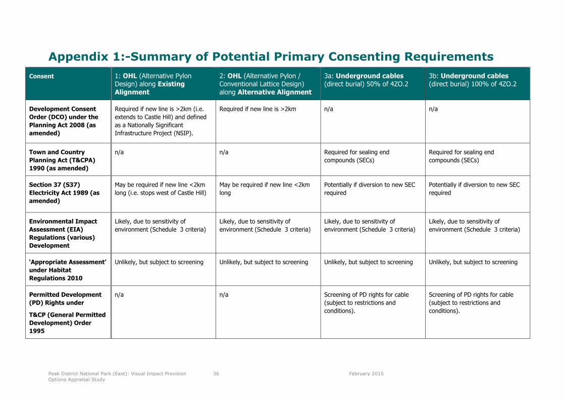
Peak District National Park (East): Visual Impact Provision
Options Appraisal Study
36 February 2015
Appendix 1:-Summary of Potential Primary Consenting Requirements
Consent 1: OHL (Alternative PylonDesign) along ExistingAlignment
2: OHL (Alternative Pylon /Conventional Lattice Design)along Alternative Alignment
3a: Underground cables(direct burial) 50% of 4ZO.2
3b: Underground cables(direct burial) 100% of 4ZO.2
Development Consent
Order (DCO) under the
Planning Act 2008 (as
amended)
Required if new line is >2km (i.e.
extends to Castle Hill) and defined
as a Nationally Significant
Infrastructure Project (NSIP).
Required if new line is >2km n/a n/a
Town and Country
Planning Act (T&CPA)
1990 (as amended)
n/a n/a Required for sealing end
compounds (SECs)
Required for sealing end
compounds (SECs)
Section 37 (S37)
Electricity Act 1989 (as
amended)
May be required if new line <2km
long (i.e. stops west of Castle Hill)
May be required if new line <2km
long
Potentially if diversion to new SEC
required
Potentially if diversion to new SEC
required
Environmental Impact
Assessment (EIA)
Regulations (various)
Development
Likely, due to sensitivity of
environment (Schedule 3 criteria)
Likely, due to sensitivity of
environment (Schedule 3 criteria)
Likely, due to sensitivity of
environment (Schedule 3 criteria)
Likely, due to sensitivity of
environment (Schedule 3 criteria)
‘Appropriate Assessment’
under Habitat
Regulations 2010
Unlikely, but subject to screening Unlikely, but subject to screening Unlikely, but subject to screening Unlikely, but subject to screening
Permitted Development
(PD) Rights under
T&CP (General Permitted
Development) Order
1995
n/a n/a Screening of PD rights for cable
(subject to restrictions and
conditions).
Screening of PD rights for cable
(subject to restrictions and
conditions).