Embed Size (px)
Citation preview
1
Geo Factsheetwww.curriculum-press.co.uk Number 319
Volcanic Activity and landforms of the Hawaiian Hot Spot
What is a hot spot? Hawaii is an oceanic hot spot, but there are continental hot spots too. Volcanic hot spots are created as ‘plumes’ of magma rise through the earth’s mantle. Mantle plumes are long-lived areas of high levels of heat flow within the mantle. Plumes consists of an upwelling long thin conduit and a bulbous head which spreads at the base of the lithosphere and produces huge volumes of magma, owing to partial melting which arises from a drop in pressure (decompression melting). These plumes possibly have their origin at the Gutenberg Discontinuity, which is the boundary that divides the outer core and mantle at a depth of 2,900 km. It is believed that heat from the core is passed to the mantle by conduction and heated portions of the lower mantle become less dense and buoyant and rise as diapirs, which will become the mantle plumes. This build-up of magma beneath the surface will eventually create volcanic activity on the ocean floor as it breaks through structurally weak areas. The volcanoes may eventually break through the surface of the ocean waters to form islands. The hot spot stays in the same place but because the plate above it moves over time thiscreates a chain of islands, with the oldest islands being furthest from the hot spot and the youngest, active volcanic islands located above the hot spot (Figure 1). Hot spots experience seismic as well as volcanic activity. Volcanic earthquakes are generated by magma movement and tectonic earthquakes occur because of structural weaknesses at the base of the volcanoes or within the crust below.
Figure 1 Hot spot formation (based on the Hawaiian Islands)
(Diagram adapted from Tilling, et al, 2001)Drawing not to scale
Pacific PlatePacific Ocean
seamounts
Niihou Kauai(5.6 - 4.9 Ma)
Oahu(3.4 Ma)
Molokai(1.8 Ma)
Maui(1.3 Ma)
MaunaLoa Kilavea
Loihi (below sea-level)
bulbous,spreadingconduit
long. narrow conduit
The Hawaiianhot spotmantle plume
Plume headis dragged byplate movement
Hawaii (0.7-0 Ma)
Ma = Millons of years oldActive volcanoes
Alternative hot spot theoriesWhilst the idea of upwelling mantle plumes is commonly referred to as the cause of hot spots, the mechanisms by which hot spots are created are still under debate. It has been suggested that hot spots may be created due to a thinning of the lithosphere when it experiences local extension (tensional forces). It has also been put forward that due to episodes of oceanic plate subduction in the past, there may be higher concentrations of water in some parts of the mantle than others and that hot spots may exist due to the presence of this water, which drives the hot spot activity by a process called hydration melting.
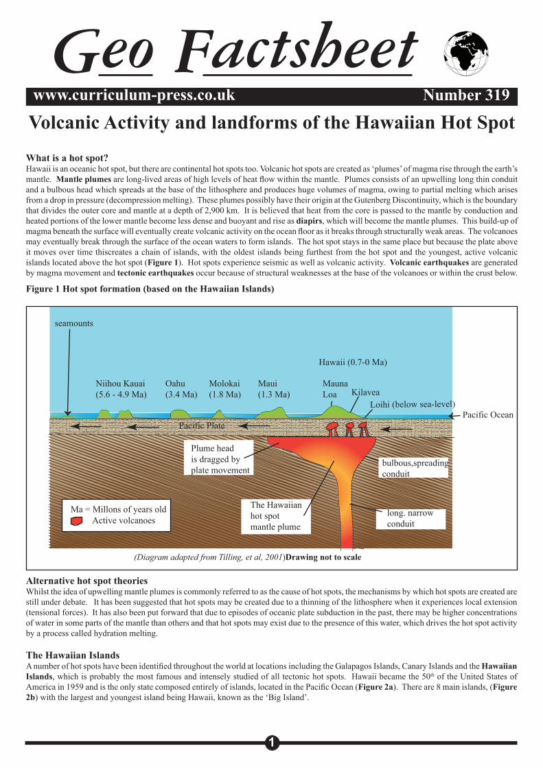
The Hawaiian IslandsA number of hot spots have been identified throughout the world at locations including the Galapagos Islands, Canary Islands and the Hawaiian Islands, which is probably the most famous and intensely studied of all tectonic hot spots. Hawaii became the 50th of the United States of America in 1959 and is the only state composed entirely of islands, located in the Pacific Ocean (Figure 2a). There are 8 main islands, (Figure 2b) with the largest and youngest island being Hawaii, known as the ‘Big Island’.
2
Volcanic Activity and landforms of the Hawaiian Hot Spot Geo Factsheet 319
Figure 2a Location of the Hawaiian Islands Figure 2b The Hawaiian Islands
At the Hawaiian hot spot, the Pacific Plate is moving in a north-westwards direction over the plume at a rate of about 10cm per year. The hot spot is believed to be around 200 miles across, with narrow channels feeding the different volcanoes. It has existed for at least 70 million years. The chain of islands that has been created, the Hawaii-Emperor seamount chain, veers north-westwards away from the ‘Big Island’ of Hawaii. A sharp bend in the chain (Figure 2a) appears approximately 2,200 miles to the northwest of Hawaii. This shows that there was a change in the direction of plate movement around 43-45 million years ago.
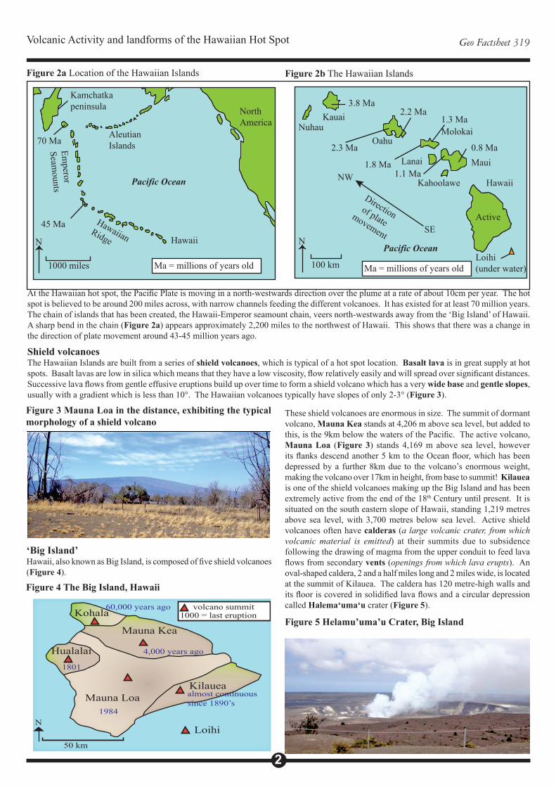
Shield volcanoesThe Hawaiian Islands are built from a series of shield volcanoes, which is typical of a hot spot location. Basalt lava is in great supply at hot spots. Basalt lavas are low in silica which means that they have a low viscosity, flow relatively easily and will spread over significant distances. Successive lava flows from gentle effusive eruptions build up over time to form a shield volcano which has a very wide base and gentle slopes, usually with a gradient which is less than 10°. The Hawaiian volcanoes typically have slopes of only 2-3° (Figure 3).
Kamchatkapeninsula
AleutianIslandsEm
perorSeam
ounts
HawaiianRidge Hawaii
NorthAmerica
70 Ma
45 Ma
Pacific Ocean
Ma = millions of years old1000 miles
N
KauaiNuhau
OahuMolokai
MauiLanai
Kahoolawe Hawaii
Loihi(under water)
Pacific Ocean
100 km
N
3.8 Ma
2.3 Ma
2.2 Ma1.3 Ma
1.8 Ma1.1 Ma
0.8 Ma
Active
Direction of plate
movement SE
NW
Ma = millions of years old
Figure 3 Mauna Loa in the distance, exhibiting the typical morphology of a shield volcano
‘Big Island’Hawaii, also known as Big Island, is composed of five shield volcanoes (Figure 4).
These shield volcanoes are enormous in size. The summit of dormant volcano, Mauna Kea stands at 4,206 m above sea level, but added to this, is the 9km below the waters of the Pacific. The active volcano, Mauna Loa (Figure 3) stands 4,169 m above sea level, however its flanks descend another 5 km to the Ocean floor, which has been depressed by a further 8km due to the volcano’s enormous weight, making the volcano over 17km in height, from base to summit! Kilauea is one of the shield volcanoes making up the Big Island and has been extremely active from the end of the 18th Century until present. It is situated on the south eastern slope of Hawaii, standing 1,219 metres above sea level, with 3,700 metres below sea level. Active shield volcanoes often have calderas (a large volcanic crater, from which volcanic material is emitted) at their summits due to subsidence following the drawing of magma from the upper conduit to feed lava flows from secondary vents (openings from which lava erupts). An oval-shaped caldera, 2 and a half miles long and 2 miles wide, is located at the summit of Kilauea. The caldera has 120 metre-high walls and its floor is covered in solidified lava flows and a circular depression called Halema‘uma‘u crater (Figure 5).
Figure 4 The Big Island, Hawaii
Figure 5 Helamu’uma’u Crater, Big IslandKohala
Mauna Kea
KilaueaMauna Loa
Hualalai
60,000 years ago
4,000 years ago
1801
1984
almost continuous since 1890’s
Loihi50 km
N
volcano summit1000 = last eruption
Volcanic Activity and landforms of the Hawaiian Hot Spot Geo Factsheet 319
3
A submarine volcanic island, Loihi, is currently forming about 20 miles from the south coast of Big Island. This island is 975 m below sea-level and is predicted to reach the surface and emerge from the Pacific Ocean in around 100,000 years. This ‘new’ volcanic island may stand alone, or may eventually join up with Mauna Loa and Kilauea to form an extension of the Big Island.
Volcanic activity Hawaiian eruptionsThe Hawaiian Islands characteristically experience effusive activity in which eruptions are characterised by the outpouring of lava flows. Lava lakes and lava fountains may also be present. Eruptions are rarely explosive. Fissure eruptions, where lava erupts from several points or vents simultaneously are evident in Hawaii. Both Kilauea and Mauna Loa have rift systems, created by extensional forces, which are occasional sites of the fissure eruptions. On the eastern flank of Kilauea craters line a rift and are known as ‘Chain of Craters’, with the crater Pu’u O’o most actively erupting at present. All Hawaiian volcanic activity at present is on the Big Island, which is currently situated above the mantle plume. The only potentially active Hawaiian volcano outside of Big Island is Heleakala on Maui, which last erupted around 1790. • Lava on Hawaii flows frequently and freely. It is not considered
as a major hazard but may be locally destructive. The Kilauea eruption which lasted from 1983-2001 destroyed 13 km of highway and approximately 180 buildings, including almost the entire destruction of the village of Kalapana. The lava on Hawaii is basaltic and flows can fall under two categories, both with Hawaiian names:o Pahoehoe, pronounced pah-hoe-ey-hoe-ey, which roughly
translates to ‘flat swirly swirly’, refers to lava flows with smooth, rope-like surfaces.
o A’a: (ahh-ahh) are flows with jagged, rough or ‘clinkery’ surfaces. Some suggest that this name was assigned when the ancient Hawaiians walked over the jagged surfaces without footwear!
• Lava lakes are rare occurrences that form when lava collects in craters. They are signs that volcanoes are active but not erupting. There is enough lava present to fill a crater floor, but not enough to create a lava flow which extends from the crater. Large gas bubbles may periodically form and burst in lava lakes. Both Mauna Loa and Kilauea have exhibited lava lakes over the last hundred years. Helama‘uma‘u was filled by a lava lake from 1838-1924 and then again in 2008.
• Lava fountains or fire fountains are emissions of incandescent lava which can reach heights of tens to hundreds of feet. Hawaiian eruptions tend to start with lava fountains, which may, to begin, erupt from a series of fissures creating a ‘curtain of fire’. This long line of fountaining occurs more or less continuously for hours and then becomes focused on a single vent. During fire fountain episodes, the lava is rapidly cooled when in contact with the air, forming dark clouds of cinders. The cooled material is often very fine and can be carried for many miles away from the vent. If the lava falls to the ground it may merge with other drops of fallen lava to form lava flows. One fire fountain on Hawaii in 1959 reached a record height of 1,900 feet! Although hugely impressive, these lava fountains are the result of what is only mildly explosive volcanic activity.
• Vog- Kilauea has been erupting almost continuously since 1986. This eruption has been associated with the release of about 2,000 tonnes of sulfur dioxide, per day, into the atmosphere. This gas is carried up the Kona coast by low-altitude winds, reacting with moisture in the air to form sulphuric acid droplets known as vog. Vog can travel 100 miles or more depending on wind patterns.
The impacts of vog are not fully understood, but are believed to give rise to respiratory problems. The famous Kona coffee plants, along with other vegetation, can be damaged by the vog and drinking water potentially contaminated.
• Laze (lava haze) is formed when lava flows reach the sea, as they often do in Hawaii, creating steam full of hydrochloric acid as the hot lava meets the cool seawater.
• Explosive eruptions arerare on Hawaii, but they do occur. Kilauea has experienced two main recorded periods of explosive activity, in 1790 and 1924. This explosivity probably resulted from expanding steam, generated from heated water on or near to the ground as it mixed with magma and hot rocks. Fields of volcanic debris are located around Kilauea, formed by its 1790 explosive eruptions. Deposits of fragments from the explosive eruptions are 35 feet deep in some places. Evidence of older explosive eruptions, for which there are no formal records, is found in the form of large pieces of volcanic debris. Around the summit crater of Mauna Loa, Mokuaweoweo, some blocks as large as 7 feet across are found near to the volcano, whilst some smaller blocks were projected out from the crater to a distance of around two miles.
An overview of volcanic material emitted in Hawaii as a result of lava fountaining and rare explosive activity can be found in Table 1.
• The term tephra is commonly used and refers to material ejected from the volcano (with more explosive eruptions the term pyroclasts may be used)
• This includes ash, which is classified as material less than 0.1 inch in diameter
• It is termed lapilli when between 0.1 and 2.5 inches• Material larger than 2.5 inches is called volcanic blocks if ejected
in a solid state and volcanic bombs if fired from the volcano in a semisolid state
• The semisolid nature of the bombs means that they can change shape as projected through the air and landing and may be described as ‘ribbon’, ‘bread-crust’ or even ‘cow-dung’-bombs!
• Scoria or cinder is irregular-shaped material the size of bombs or lapilli. It is formed from frothy lava and which may contain small holes formed as lava from which gas was trying to escape cooled very rapidly during fountaining. These holes are called vesicles and if the scoria has these holes then it is termed pumice.
• Some pumice which is particularly light is called reticulite or thread-lace scoria. Given its extremely fine and light nature, it can be carried many miles from the fountains by the wind.
• If the scoria remains in a plastic state when it hits the ground it may splat or splash and is called spatter, if a number of ‘blobs’ join together they are known as agglutinate or welded spatter.
• In flight, droplets of lava from the fire fountains may take on a streamlined, aerodynamic shape, such as in the form of solidified droplets. They are called Pele’s tears after the Hawaiian Goddess of fire who, in folklore, is believed to migrate from island to island, creating earthquakes by stamping her feet and volcanic eruptions by digging with her ‘paoa’, a magic stick.
• Pele’s tears move through the air leaving a train of extremely rapidly-cooled, fine, hair-like strands of lava behind, which look a little like spun gold. These shiny strands of what is actually volcanic glass are called Pele’s hair.
• Seaweed of Pele (limu o Pele) can be formed as explosive activity results from lava entering the sea. These are delicate, thin flakes of basaltic glass which may measure a few inches across.
Table 1: Volcanic material found on Hawaii
4
Volcanic Activity and landforms of the Hawaiian Hot Spot Geo Factsheet 319
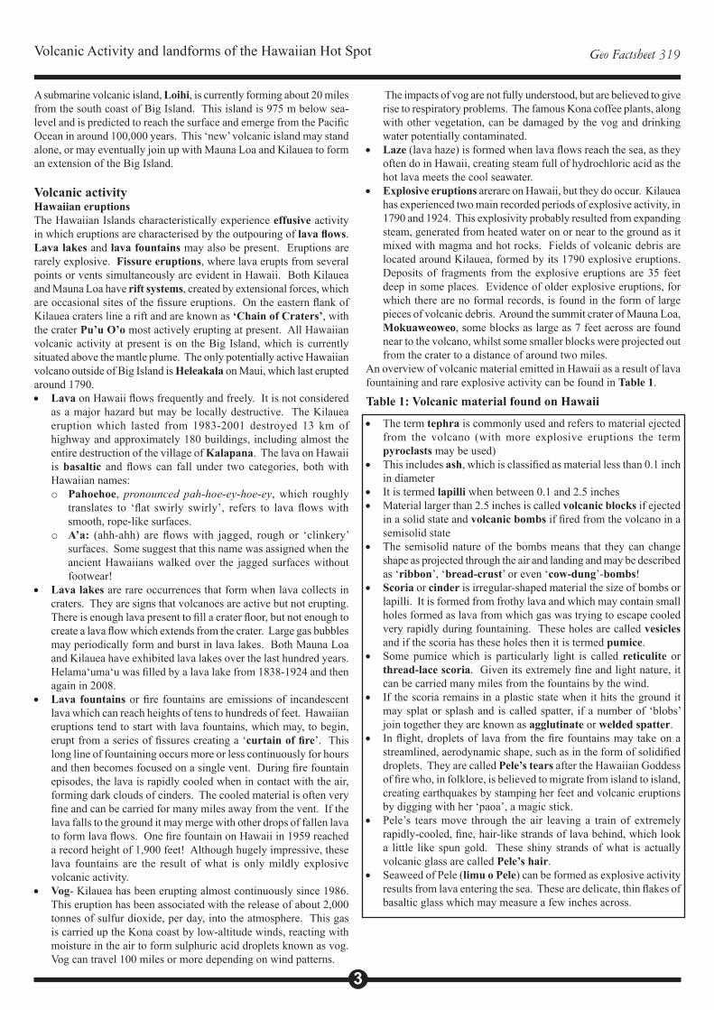
Features of Hawaii’s volcanic landscapeVolcanic activity, most especially lava flows give rise to some striking features on Hawaii’s landscape. Solidified flows of A’a and pahoehoe as well as large areas of land strewn with tephra are most evident on Big Island, whilst both the older islands and Hawaii show evidence of their volcanically active past and present with craters, lava tubes and black sand beaches, amongst other features. On Big Island calderas such as Helema‘uma‘u and craters, such as Pu ‘u O’o, provide evidence that it is volcanically active. Diamond Head Crater on Oahu provides evidence that this island was once volcanically active and that volcanic materials would have been emitted from this crater (Figure 6). Figure 6. Diamond Head Crater, Oahu
Left: The rim of the crater can be seen in this photograph surrounding the flat base of the crater which is now home to a military base and vegetation. Below: Diamond Head in the distance provides a backdrop for the world-famous Waikiki Beach.
Diamond Head Crater Rim
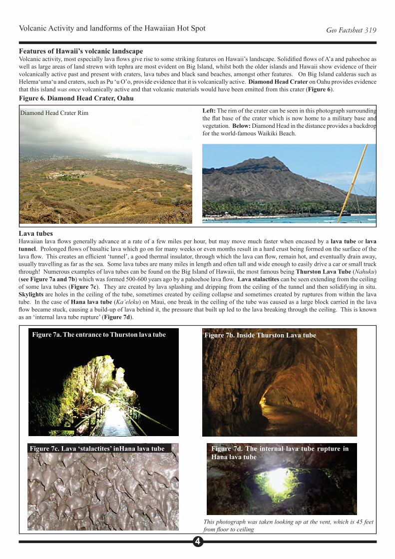
Lava tubesHawaiian lava flows generally advance at a rate of a few miles per hour, but may move much faster when encased by a lava tube or lava tunnel. Prolonged flows of basaltic lava which go on for many weeks or even months result in a hard crust being formed on the surface of the lava flow. This creates an efficient ‘tunnel’, a good thermal insulator, through which the lava can flow, remain hot, and eventually drain away, usually travelling as far as the sea. Some lava tubes are many miles in length and often tall and wide enough to easily drive a car or small truck through! Numerous examples of lava tubes can be found on the Big Island of Hawaii, the most famous being Thurston Lava Tube (Nahuku) (see Figure 7a and 7b) which was formed 500-600 years ago by a pahoehoe lava flow. Lava stalactites can be seen extending from the ceiling of some lava tubes (Figure 7c). They are created by lava splashing and dripping from the ceiling of the tunnel and then solidifying in situ. Skylights are holes in the ceiling of the tube, sometimes created by ceiling collapse and sometimes created by ruptures from within the lava tube. In the case of Hana lava tube (Ka’eleku) on Maui, one break in the ceiling of the tube was caused as a large block carried in the lava flow became stuck, causing a build-up of lava behind it, the pressure that built up led to the lava breaking through the ceiling. This is known as an ‘internal lava tube rupture’ (Figure 7d).
Figure 7a. The entrance to Thurston lava tube Figure 7b. Inside Thurston Lava tube
Figure 7c. Lava ‘stalactites’ inHana lava tube Figure 7d. The internal lava tube rupture in Hana lava tube
This photograph was taken looking up at the vent, which is 45 feet from floor to ceiling
Volcanic Activity and landforms of the Hawaiian Hot Spot Geo Factsheet 319
5
The ceiling of Ka’eleku lava tube, formed 960 years ago, is about 30-60 metres thick. Lava flowed through this tunnel for about two years and carved down into the floor as it did so. Horizontal lines can be seen on the tunnel walls marking the changing levels of the Lava flow. Contraction cracks (cracks in the tunnel walls from when the lava cooled) are also evident. As it cools, lava typically contracts by 1-2%. Red colouring in the walls and ceiling of the lava tube indicates the presence of iron in the lava.
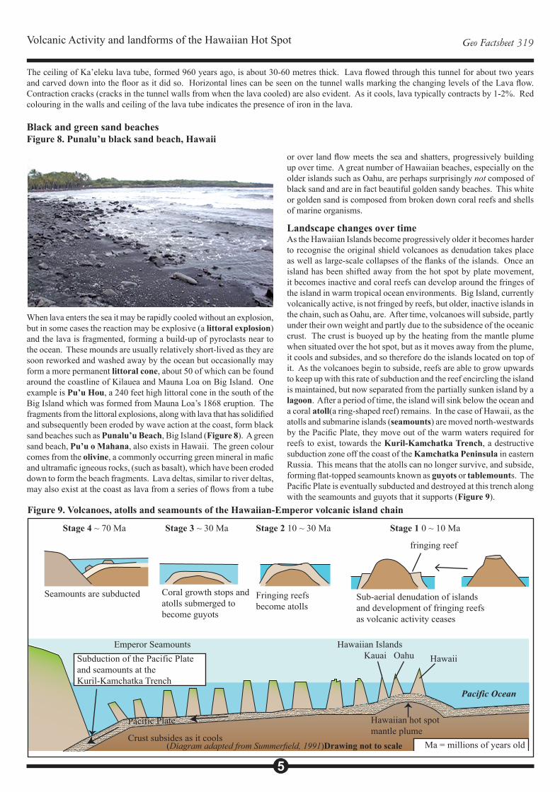
Black and green sand beachesFigure 8. Punalu’u black sand beach, Hawaii
When lava enters the sea it may be rapidly cooled without an explosion, but in some cases the reaction may be explosive (a littoral explosion) and the lava is fragmented, forming a build-up of pyroclasts near to the ocean. These mounds are usually relatively short-lived as they are soon reworked and washed away by the ocean but occasionally may form a more permanent littoral cone, about 50 of which can be found around the coastline of Kilauea and Mauna Loa on Big Island. One example is Pu’u Hou, a 240 feet high littoral cone in the south of the Big Island which was formed from Mauna Loa’s 1868 eruption. The fragments from the littoral explosions, along with lava that has solidified and subsequently been eroded by wave action at the coast, form black sand beaches such as Punalu’u Beach, Big Island (Figure 8). A green sand beach, Pu’u o Mahana, also exists in Hawaii. The green colour comes from the olivine, a commonly occurring green mineral in mafic and ultramafic igneous rocks, (such as basalt), which have been eroded down to form the beach fragments. Lava deltas, similar to river deltas, may also exist at the coast as lava from a series of flows from a tube
or over land flow meets the sea and shatters, progressively building up over time. A great number of Hawaiian beaches, especially on the older islands such as Oahu, are perhaps surprisingly not composed of black sand and are in fact beautiful golden sandy beaches. This white or golden sand is composed from broken down coral reefs and shells of marine organisms.
Landscape changes over timeAs the Hawaiian Islands become progressively older it becomes harder to recognise the original shield volcanoes as denudation takes place as well as large-scale collapses of the flanks of the islands. Once an island has been shifted away from the hot spot by plate movement, it becomes inactive and coral reefs can develop around the fringes of the island in warm tropical ocean environments. Big Island, currently volcanically active, is not fringed by reefs, but older, inactive islands in the chain, such as Oahu, are. After time, volcanoes will subside, partly under their own weight and partly due to the subsidence of the oceanic crust. The crust is buoyed up by the heating from the mantle plume when situated over the hot spot, but as it moves away from the plume, it cools and subsides, and so therefore do the islands located on top of it. As the volcanoes begin to subside, reefs are able to grow upwards to keep up with this rate of subduction and the reef encircling the island is maintained, but now separated from the partially sunken island by a lagoon. After a period of time, the island will sink below the ocean and a coral atoll(a ring-shaped reef) remains. In the case of Hawaii, as the atolls and submarine islands (seamounts) are moved north-westwards by the Pacific Plate, they move out of the warm waters required for reefs to exist, towards the Kuril-Kamchatka Trench, a destructive subduction zone off the coast of the Kamchatka Peninsula in eastern Russia. This means that the atolls can no longer survive, and subside, forming flat-topped seamounts known as guyots or tablemounts. The Pacific Plate is eventually subducted and destroyed at this trench along with the seamounts and guyots that it supports (Figure 9).
Figure 9. Volcanoes, atolls and seamounts of the Hawaiian-Emperor volcanic island chain
Stage 4 ~ 70 Ma Stage 3 ~ 30 Ma Stage 2 10 ~ 30 Ma Stage 1 0 ~ 10 Ma
fringing reef
Sub-aerial denudation of islandsand development of fringing reefsas volcanic activity ceases
Fringing reefsbecome atolls
Coral growth stops andatolls submerged to become guyots
Seamounts are subducted
Emperor Seamounts Hawaiian IslandsKauai Oahu Hawaii
Pacific Ocean
Pacific Plate
Crust subsides as it cools
Hawaiian hot spot mantle plume
Subduction of the Pacific Plate and seamounts at the Kuril-Kamchatka Trench
Ma = millions of years old(Diagram adapted from Summerfield, 1991)Drawing not to scale
Volcanic Activity and landforms of the Hawaiian Hot Spot Geo Factsheet 319
6
ConclusionThe Hawaiian Islands were created by the movement of the Pacific Plate over a mantle plume. They form part of a long chain of islands which subside to form seamounts, atolls and guyots over time. The islands experience non-violent volcanic activity which is characterised by fire fountaining, low-viscosity basaltic lava flows and only occasional more violent eruptive episodes. The nature of Hawaii’s volcanic activity determines the morphology of the shield volcanoes which create the islands and gives rise to the landforms, such as lava tubes, black sand beaches and also to the variety of tephra which can be found scattered on the volcano slopes. The Hawaiian Islands are a fantastic example of the volcanic activity and landscape features which are typical of many ocean island hot spots.
References and further reading• Grigg, R. W. (2012) In the Beginning: Archipelago The Origin and Discovery of the Hawaiian Islands Island Heritage Publishing• Parfitt, E. A. and Wilson, L. (2008) Fundamentals of Physical Volcanology Blackwell• Rosi, M, Papale, P, Lupi, L and Stoppato, M. (2003) Volcanoes Firefly• Rothery, D.A. (2010) Teach Yourself: Volcanoes, Earthquakes and Tsunamis Hodder Education • Summerfield, M. A. (1991) Global Geomorphology Pearson• Tilling, R. S., Heliker, C. and Swanson, D.A. (2010) Eruptions of Hawaiian Volcanoes – Past, Present and Future USGS
Useful websites• USGS Hawaiian Volcano Observatory http://hvo.wr.usgs.gov/• USGS Volcano Hazards Program http://volcanoes.usgs.gov/• San Diego State University http://www.geology.sdsu.edu/how_volcanoes_work/ (Particularly the page on Hawaiian eruptions. This
website can be used to research other fascinating volcanic features and landforms such as hornitos, lava draperies and tumuli which have not been discussed here. Photographs of tephra such as Pele’s hair and tears as well as links to useful web pages can also be found on this excellent website).
• Smithsonian Institution Global Volcanism Program http://www.volcano.si.edu/
Acknowledgements; This Geo Factsheet was researched and written by Kate Cowan following a visit to the Hawaiian Islands in 2012. Kate is a Teacher of Geography at King Edward VI High School for Girls, Birmingham. Curriculum Press, Bank House, 105 King Street, Wellington, TF1 1NUGeopress Factsheets may be copied free of charge by teaching staff or students, provided that their school is a registered subscriber.No part of these Factsheets may be reproduced, stored in a retrieval system, or transmitted, in any other form or by any other means, without the prior permission of the publisher. ISSN 1351-5136