Embed Size (px)
Citation preview
Brief coastal vulnerability assessment for
the City of Cocoa Beach, conducted utilizing
available NOAA and UF GeoPlan tools.
Vulnerability Assessment City of Cocoa Beach
Fall 2016 – Coastal Resiliency Tools Buffet
East Central Florida Regional Planning Council
Tampa Bay Regional Planning Council
Asssistance provided by Brevard UF IFAS
Funded by Florida Department of Economic
Opportunity
Page 1 of 6
Vulnerability Assessment – City of Cocoa Beach Background The East Central Florida and Tampa Bay Regional Planning Councils participated in a statewide Train the Trainer program
funded by the Florida Department of Economic Opportunity. The purpose of the program was to engage local coastal
planners, engineers and other sectors in the discussion of resiliency and provide them with a hands on training of various
NOAA Digital Coast platforms as well as the UF Geoplan Sea Level Scenario Sketch Planning Tool and provide training on
the development of vulnerability assessments, utilizing a pilot area. The City of Cocoa Beach was chosen as the pilot area
for a preliminary vulnerability assessment. The training was held on October 26, 2016 at the Volusia County Emergency
Operations Center. Originally, the NOAA Coastal Flood Exposure Mapper was to be utilized as the main tool to conduct
the vulnerability assessment, thus providing an overview of social, economic and natural vulnerabilities to coastal flooding
and sea level rise. However, as the training was approaching the vulnerability assessment portion, a technical issue
occurred at the NOAA Offices in Charleston and access to the NOAA Digital Coast Tools was cut for the remainder of the
training. As a result, the vulnerability analysis switched to focus on the UF Geoplan Sea Level Scenario Sketch Planning
Tool, a more transportation oriented analysis program. The information provided in this assessment reflect the exercise
conducted by the workshop attendees utilizing the sketch planning tool, local knowledge and other resources available
on the internet. Additionally, the Brevard County UF IFAS Extension Services provided additional review and development
of the assessment.
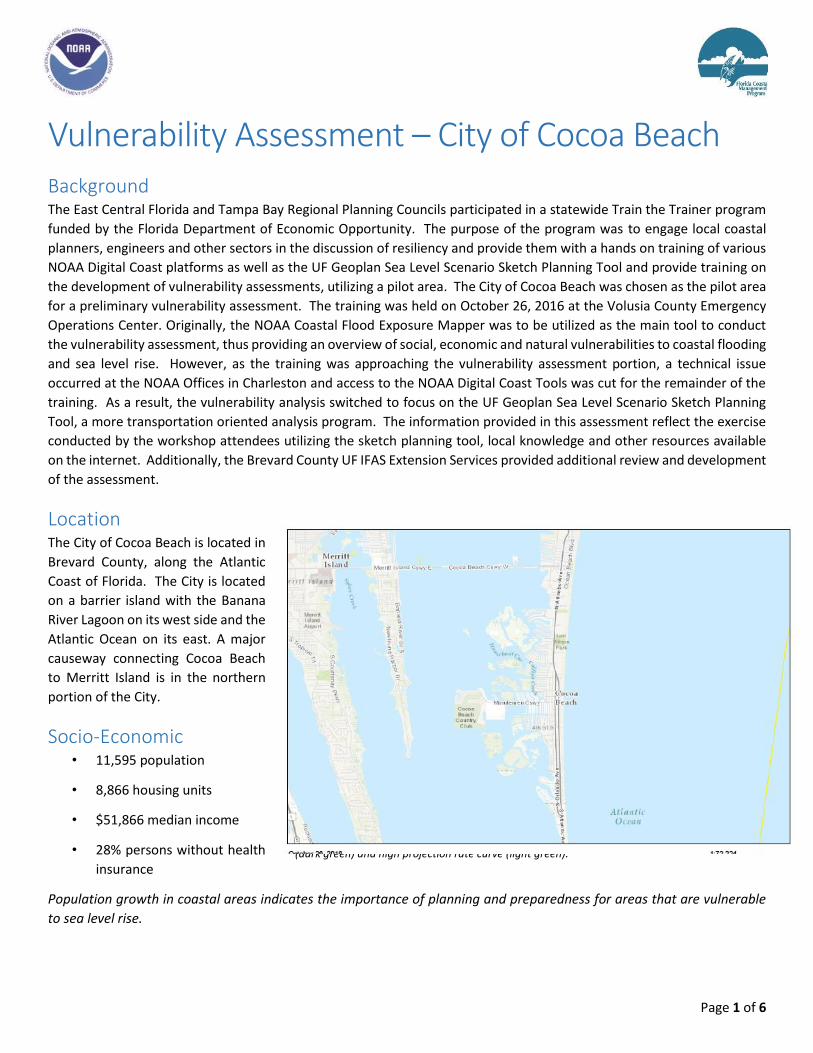
Location The City of Cocoa Beach is located in
Brevard County, along the Atlantic
Coast of Florida. The City is located
on a barrier island with the Banana
River Lagoon on its west side and the
Atlantic Ocean on its east. A major
causeway connecting Cocoa Beach
to Merritt Island is in the northern
portion of the City.
Socio-Economic • 11,595 population
• 8,866 housing units
• $51,866 median income
• 28% persons without health
insurance
Population growth in coastal areas indicates the importance of planning and preparedness for areas that are vulnerable
to sea level rise.
Potential sea level rise impacts by 2070 using USACE intermediate projection rate curve
(dark green) and high projection rate curve (light green).
Page 2 of 6
Key Assets The City of Cocoa Beach is a world beach destination and has numerous hotels and motels to house tourists. The City also
has 3 schools (2 Elementary and 1 Junior/Senior High School), a local hospital, and a wastewater treatment plant. It is also
home to the world famous “One of a Kind” Ron Jon Surf Shop and Cocoa Beach Pier. The Thousand Islands area of Cocoa
Beach is a group of natural, modified, and spoil islands that were reshaped by development and efforts to control
mosquitoes. In recent years, the south Thousand Islands have been managed by the Brevard County Environmentally
Endangered Lands (EEL) Program and is considered a conservation area. The north Thousand Islands is managed by the
City of Cocoa Beach and is also conservation and recreation managed lands. Restoration efforts include removing invasive
plants such as Brazilian pepper and Australian pine, and restoring habitat. The City of Cocoa Beach is dredging muck from
the channel and canal waterways.
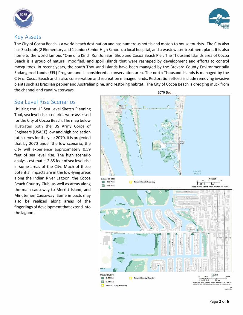
Sea Level Rise Scenarios Utilizing the UF Sea Level Sketch Planning
Tool, sea level rise scenarios were assessed
for the City of Cocoa Beach. The map below
illustrates both the US Army Corps of
Engineers (USACE) low and high projection
rate curves for the year 2070. It is projected
that by 2070 under the low scenario, the
City will experience approximately 0.59
feet of sea level rise. The high scenario
analysis estimates 2.85 feet of sea level rise
in some areas of the City. Much of these
potential impacts are in the low-lying areas
along the Indian River Lagoon, the Cocoa
Beach Country Club, as well as areas along
the main causeway to Merritt Island, and
Minutemen Causeway. Some impacts may
also be realized along areas of the
fingerlings of development that extend into
the lagoon.
Page 3 of 6
Vulnerable Assets By 2070, under the USACE high projection rate curve, the following assets have been determined to be vulnerable. This
would include the asset site itself, access to the site, or the area surrounding the property.
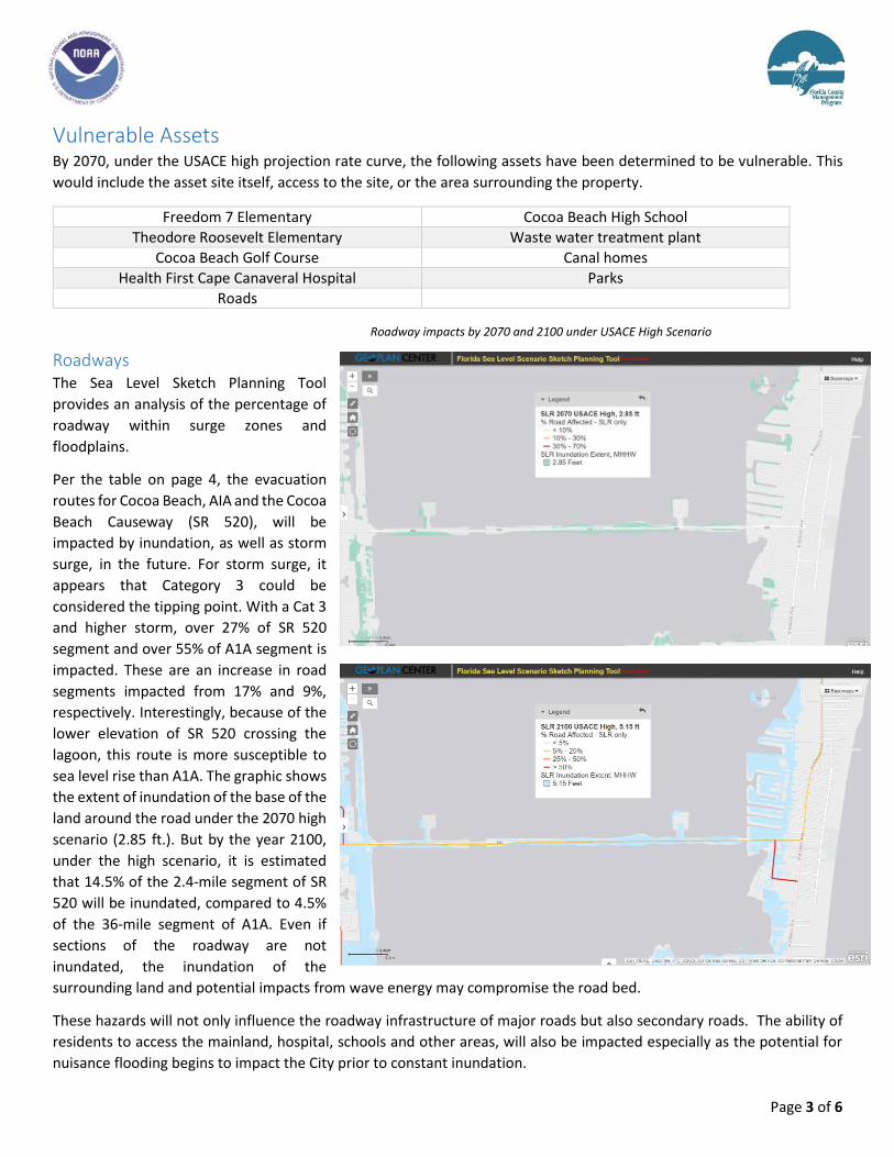
Roadways The Sea Level Sketch Planning Tool
provides an analysis of the percentage of
roadway within surge zones and
floodplains.
Per the table on page 4, the evacuation
routes for Cocoa Beach, AIA and the Cocoa
Beach Causeway (SR 520), will be
impacted by inundation, as well as storm
surge, in the future. For storm surge, it
appears that Category 3 could be
considered the tipping point. With a Cat 3
and higher storm, over 27% of SR 520
segment and over 55% of A1A segment is
impacted. These are an increase in road
segments impacted from 17% and 9%,
respectively. Interestingly, because of the
lower elevation of SR 520 crossing the
lagoon, this route is more susceptible to
sea level rise than A1A. The graphic shows
the extent of inundation of the base of the
land around the road under the 2070 high
scenario (2.85 ft.). But by the year 2100,
under the high scenario, it is estimated
that 14.5% of the 2.4-mile segment of SR
520 will be inundated, compared to 4.5%
of the 36-mile segment of A1A. Even if
sections of the roadway are not
inundated, the inundation of the
surrounding land and potential impacts from wave energy may compromise the road bed.
These hazards will not only influence the roadway infrastructure of major roads but also secondary roads. The ability of
residents to access the mainland, hospital, schools and other areas, will also be impacted especially as the potential for
nuisance flooding begins to impact the City prior to constant inundation.
Freedom 7 Elementary Cocoa Beach High School
Theodore Roosevelt Elementary Waste water treatment plant
Cocoa Beach Golf Course Canal homes
Health First Cape Canaveral Hospital Parks
Roads
Roadway impacts by 2070 and 2100 under USACE High Scenario
Page 4 of 6
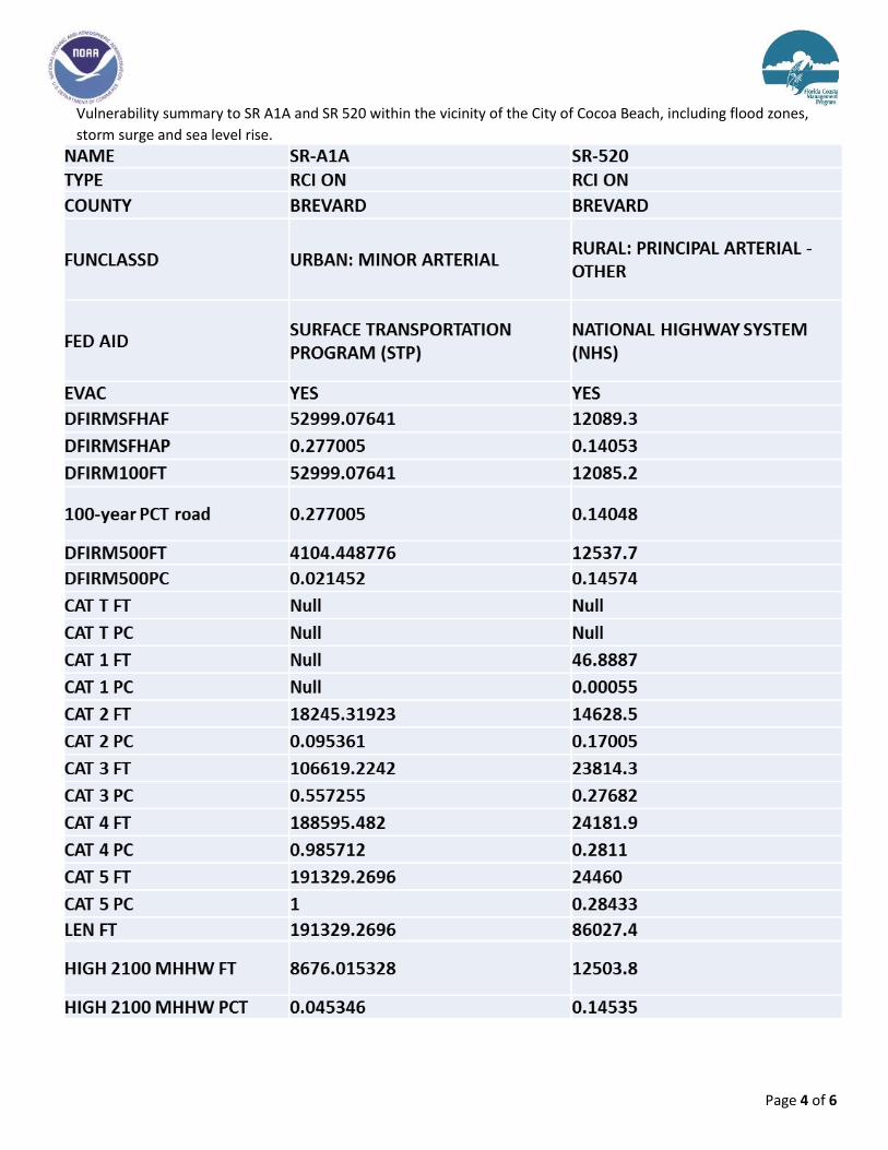
Vulnerability summary to SR A1A and SR 520 within the vicinity of the City of Cocoa Beach, including flood zones,
storm surge and sea level rise.
Page 5 of 6
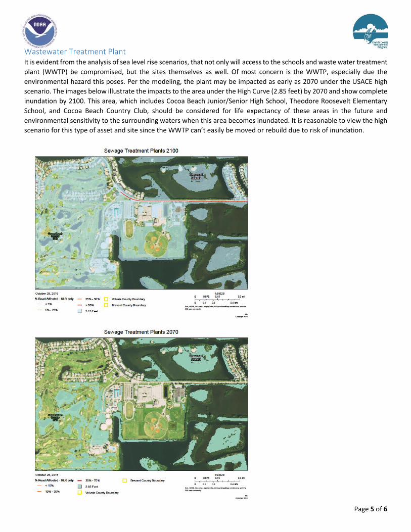
Wastewater Treatment Plant It is evident from the analysis of sea level rise scenarios, that not only will access to the schools and waste water treatment
plant (WWTP) be compromised, but the sites themselves as well. Of most concern is the WWTP, especially due the
environmental hazard this poses. Per the modeling, the plant may be impacted as early as 2070 under the USACE high
scenario. The images below illustrate the impacts to the area under the High Curve (2.85 feet) by 2070 and show complete
inundation by 2100. This area, which includes Cocoa Beach Junior/Senior High School, Theodore Roosevelt Elementary
School, and Cocoa Beach Country Club, should be considered for life expectancy of these areas in the future and
environmental sensitivity to the surrounding waters when this area becomes inundated. It is reasonable to view the high
scenario for this type of asset and site since the WWTP can’t easily be moved or rebuild due to risk of inundation.
Page 6 of 6
Recommendations Since most vulnerable areas in Cocoa Beach are located along the
Banana River Lagoon, these are the areas that are recommended
to be reviewed first for future planning.
It is recommended that discussions and plans begin, if they
haven’t already, on the potential relocation of the hospital and
waste water treatment plant. Discussions should include where
the relocation would occur, by what timeframe, as well as how to
efficiently and environmentally soundly, remove the existing
infrastructure. Additionally, the future use of this property should
also be discussed to continue a revenue for the City from the
properties.
Analysis into the raising of the causeway should occur and
consider bridging the causeway for its entirety, raising the run ups
as these are also vulnerable on both sides of the lagoon. Another
option could be to remove the SR 520 causeway and reroute
traffic to SR 528. Short term shoreline restoration and
reinforcement could be implemented to help extend the life the
causeway. The Causeway Vulnerability Study from the early 2000s
should be readdressed with the newest data available.
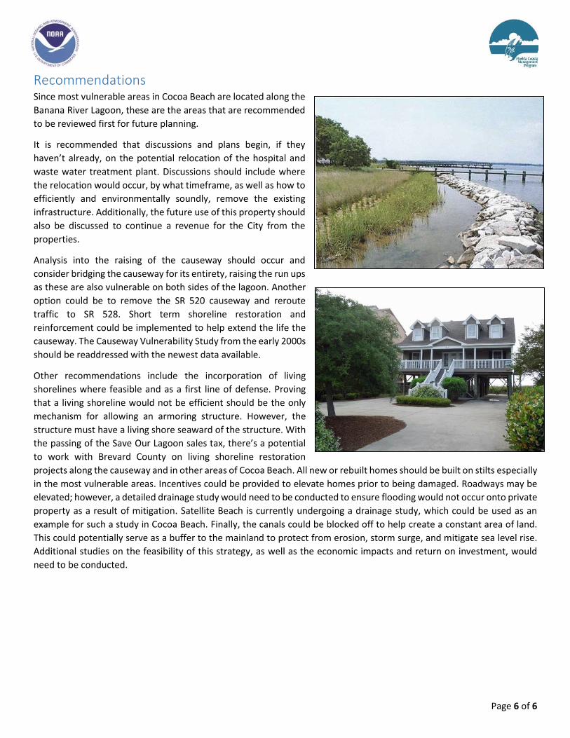
Other recommendations include the incorporation of living
shorelines where feasible and as a first line of defense. Proving
that a living shoreline would not be efficient should be the only
mechanism for allowing an armoring structure. However, the
structure must have a living shore seaward of the structure. With
the passing of the Save Our Lagoon sales tax, there’s a potential
to work with Brevard County on living shoreline restoration
projects along the causeway and in other areas of Cocoa Beach. All new or rebuilt homes should be built on stilts especially
in the most vulnerable areas. Incentives could be provided to elevate homes prior to being damaged. Roadways may be
elevated; however, a detailed drainage study would need to be conducted to ensure flooding would not occur onto private
property as a result of mitigation. Satellite Beach is currently undergoing a drainage study, which could be used as an
example for such a study in Cocoa Beach. Finally, the canals could be blocked off to help create a constant area of land.
This could potentially serve as a buffer to the mainland to protect from erosion, storm surge, and mitigate sea level rise.
Additional studies on the feasibility of this strategy, as well as the economic impacts and return on investment, would
need to be conducted.