Embed Size (px)
Citation preview
ISL Engineering • NORR Architects Engineers Planners • Urban Design Associates • Watt Consulting Group
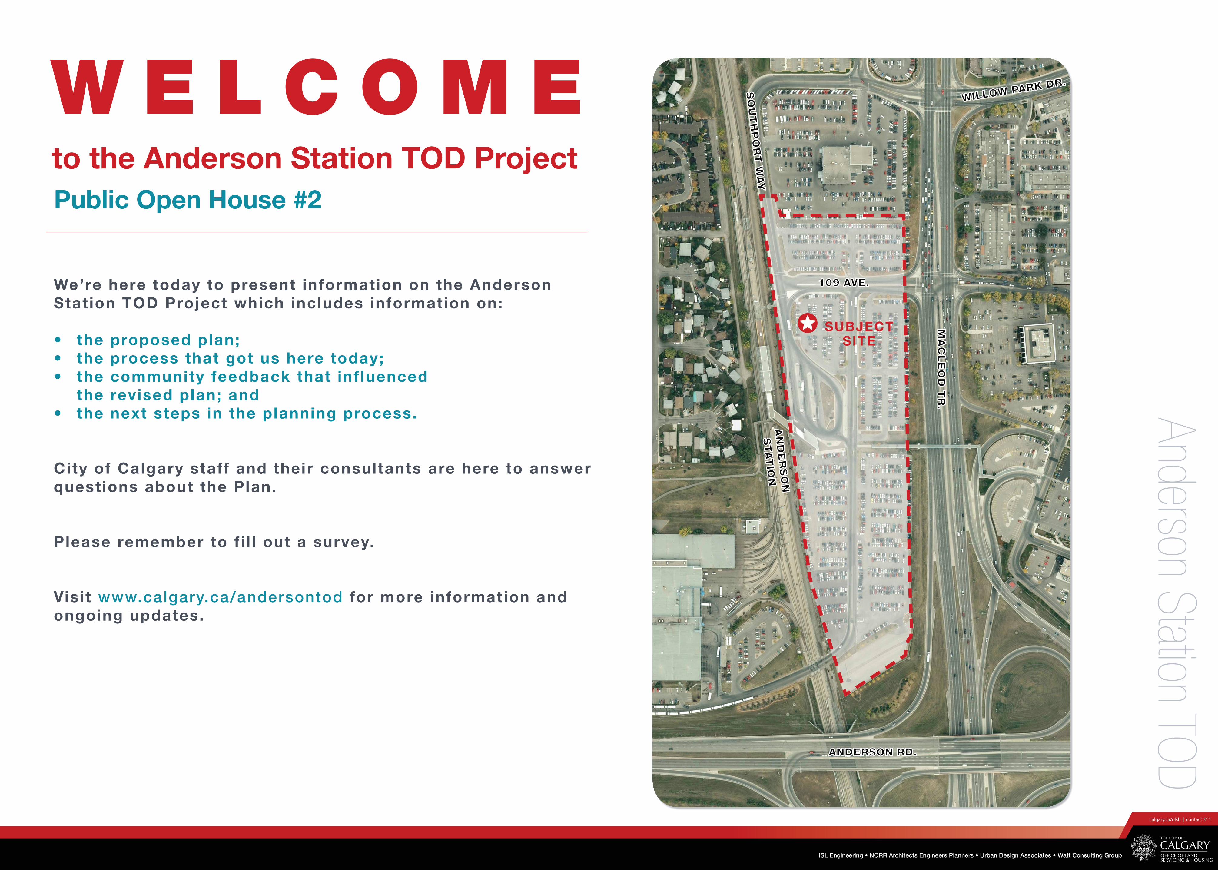
Anderson Station TODW E L C O M EW E L C O M EPublic Open House #2Public Open House #2
to the Anderson Station TOD Project to the Anderson Station TOD Project
MA
CLE
OD
TR
.M
AC
LE
OD
TR
.
ANDERSON RD.ANDERSON RD.
AN
DE
RSO
NA
ND
ER
SO
N
STA
TIO
NSTA
TIO
N
SO
UTH
PO
RT W
AY
SO
UTH
PO
RT W
AY
WILLOW PARK DR.
WILLOW PARK DR.
SUBJECT SITE
109 AVE. 109 AVE. We’re here today to present information on the Anderson We’re here today to present information on the Anderson Station TOD Project which includes information on:Station TOD Project which includes information on:
• the proposed plan;• the proposed plan;• the process that got us here today;• the process that got us here today;• the community feedback that inf luenced • the community feedback that inf luenced
the revised plan; andthe revised plan; and• the next steps in the planning process. • the next steps in the planning process.
City of Calgary staff and their consultants are here to answer City of Calgary staff and their consultants are here to answer questions about the Plan. questions about the Plan.
Please remember to f i l l out a survey.Please remember to f i l l out a survey.
Visit Visit www.calgary.ca/andersontodwww.calgary.ca/andersontod for more information and for more information and ongoing updates. ongoing updates.

ISL Engineering • NORR Architects Engineers Planners • Urban Design Associates • Watt Consulting Group
Anderson Station TODP R O J E C T O V E R V I E W
What is the Anderson Station Area Plan (SAP), and how does it relate to this project?
The City of Calgary has been conducting two separate but related planning processes.
The Anderson Station Area Plan (SAP) process involves developing policy for the larger Station Area which includes ± 250 acres around Anderson Station.
The other planning process applies the SAP policy and creates a more detailed land use plan and conceptual design for the 20 acres next to the Anderson LRT Station. This process will result in an Outline Plan & Land Use Amendment that will be presented to City Council.
Project Overview
In 2007, City Council identifi ed Anderson Station as a Transit Oriented Development (TOD) priority and directed the Offi ce of Land Servicing & Housing, a division of The City of Calgary, to prepare a comprehensive plan to redevelop the City-owned land at the station into a model TOD.
The project involves 20 acres of land which includes the Anderson LRT Station, bus terminal and surface parking lot for transit riders.
The purpose of the project is to redevelop the existing parking lot into a vibrant, pedestrian oriented, mixed use urban village that refl ects Council approved policy. Public parking will be provided in the new plan, however, fewer stalls will be available to transit riders.
What is Transit Oriented Development (TOD)?
Transit Oriented Development (TOD) is a compact, mixed-use community within walking distance of a transit station that mixes residential, retail, offi ce, open space and public uses in a way that makes it convenient to travel on foot or by public transportation instead of by car. Who is OLSH?
The Offi ce of Land Servicing & Housing (OLSH) is a business unit at The City of Calgary that plans and services City-owned lands near LRT stations for Transit Oriented Development (TOD).
Station Area Plan Boundary
Outline Plan / Land Use Boundary
SUBJECT SITE
MA
CLE
OD
TR
.M
AC
LE
OD
TR
.
ANDERSON RD.ANDERSON RD.
AN
DE
RSO
NA
ND
ER
SO
N
STA
TIO
NSTA
TIO
N
SO
UTH
PO
RT W
AY
SO
UTH
PO
RT W
AY
WILLOW PARK DR.
WILLOW PARK DR.
109 AVE.109 AVE.

ISL Engineering • NORR Architects Engineers Planners • Urban Design Associates • Watt Consulting Group
Anderson Station TOD
Transit Oriented Development Policy Guidelines (2004)
These Guidelines provide more specifi c direction on land use and urban design for development within a 600 metre radius of LRT Stations. Key objectives of the Guidelines include:
1. Ensure transit supportive land uses.
2. Increase density around transit stations.
3. Create pedestrian-oriented design.
4. Make each station a “place”.
5. Manage parking, bus and vehicular traffi c.
6. Plan in the context with the local communities.
P O L I C Y C O N T E X T
Municipal Development Plan + Calgary Transportation Plan (2009)
The Municipal Development Plan and Calgary Transportation Plan provide a vision for long term growth and development over the next 60 years. This vision focuses on a more compact city that is made up of “complete communities” which offer safe and easy pedestrian access to shopping, opportunities for cycling and commuting on transit, and provides quality open space.
A key objective of these plans is to optimize population and job growth within walking distance of transit. This form of
development is Transit Oriented Development (TOD).
Draft Anderson Station Area Plan
The Draft Anderson SAP is based on the principles of TOD. It provides strategic direction for the comprehensive redevelopment of the larger (± 250 acres) around Anderson Station and includes policy on land use, built form, density, public space, new connections and improvements to the existing pedestrian, bicycle, transit and roadway systems.

ISL Engineering • NORR Architects Engineers Planners • Urban Design Associates • Watt Consulting Group
Anderson Station TODP R O J E C T S U M M A R Y
• Review information compiled through the Station Area Plan process and previous Outline Plan & Land Use proposal to determine the new path forward
Information Review
1 Phase
• Additional research and analysis to establish a realistic development program consistent with TOD objectives
• Studies include: Market Analysis, Retail and Hotel Studies, Site Infrastructure Assessment
Research & Analysis
2Phase
• Create a Vision• Develop 4 concepts• Refine market and site
infrastructure assessments• Test and refine the land
use, built form, open space and transportation framework
Concept Development
3 Phase
• Refine the proposed concept
• Develop a phasing strategy
• Finalize the Master Plan• Prepare Transportation
Impact Assessment
Master Planning
4 Phase
Planning Approvals
5 Phase
Engineering Your Future Si
Contact Information: D.A. Watt Consulting #310, 3016 - 5 Avenue NE Calgary, Alberta T2A 6K4 Phone : (403) 273 - 9001 Fax : (403) 273 - 3440
www.dawatt.com
ANDERSON STATION Transportation Study
DEVELOPER OUTREACHSUMMARY REPORT OLSHANDERSON STATION TOD DEVELOPMENT
JANUARY 20, 2014
• Prepare and submit the Outline Plan and Land Use Application
• Application is reviewed by the City of Calgary
• Refine the application based on feedback
2011
2007- City Council identified
Anderson Station as a Transit Oriented Development priority station
- The Office of Land Servicing & Housing prepares a draft Outline Plan and Land Use Amendment and gathers public input at a number of events for the redevelopment of Anderson Station
2008- The City prepares a draft Station Area Plan (SAP)
2009 - A Transportation Study is initiated for the SAP
2010 - Due to resourcing
constraints the Transportation Study was put on hold along with the Outline Plan & Land Use applications
2007 2012 Spr ing 2013 Spr ing 2014 Summer 2014
STAKEHOLDER EVENTS
• Meetings with City of Calgary Stakeholders (Transit, Parks, Planning & Transportation)
PUBLIC EVENTS
Open House #2 (May 15, 2014)
• Presentation of ‘what we heard’ and the preferred concept
STAKEHOLDER EVENTS
• Meetings with City of Calgary Stakeholders
• Meetings with Community Associations
• Stakeholder Interviews (SAP) - Mar. 2012STAKEHOLDER EVENTS
• Stakeholder Interviews for the SAP (Mar. 2012)
• Meetings with Community representatives and business owners (Apr. 2012)
• Anderson TOD Project Community Workshop
(Jun. 2012)
PUBLIC EVENTS
Open House (Nov. 2012)
• Presentation of ‘what we heard’ from the June workshops and update on transportation study
STAKEHOLDER EVENTS
• Review Transportation Study with communities
• Continue dialogue through community associations and on-line updates
WE ARE HERE
STAKEHOLDER EVENTS
• Meetings with City of Calgary Stakeholders
PUBLIC EVENTS
Open House #1 (May 22, 2013)
• Presentation of 4 preliminary concepts
Background
WE ARE HERE
Ped/
MR 2MR 1
Improved Ped/Bicycle Connection
R-in o
nly
PUBLIC EVENTS
• Public engagement on the Anderson Station Area Plan
• Public Hearing of Council
We want to make Anderson Station a successful, urban destination. To accomplish this, we needed to re-assess the plan that was presented in 2008. This chart summarizes the process that got us here today.
Southwood Park
Ped/Bicycle Br
So
uth
po
rt Way
109
lgary Transit aintenance Facility
Macle
od
Tra
il
Anderson Station
MR 2
MR 1
Improved Ped/Bicycle Connection
R-in o
nly
MR 3
Transit Parking
Anderson Station TODOutline Plan & Land Use Re-designationPre-application Submission
Office of Land Servicing & HousingApril 22, 2014
At Open House #1 in May 2013, we presented four concepts reflecting our new vision of Anderson
Anderson TOD Project, Public Open House, May 2013
W H A T W E H E A R D What we heard How the new plan addresse
The new plan aims to:
Land UseA mix of uses (residential, commercial and retail) is preferred to help create activity throughout the day and night.
Provide a variety of uses and pIntroduce new jobs to the areaEstablish more park areas, pathlinkages
Built Form, Height & Density“Mid-rise” buidlings are preferred, with higher buildings closer to Macleod Trail.
Accommodate changes in buildlocating higher buildings near Mbuildings closer to existing resi
Public Parks & Open SpacePark spaces should accommodate all ages (seniors and children), and they should be functional and safe.
Create vibrant and interesting of development Provide 3 new park spaces thaDevelop high quality streetscap
LinkagesImprove connections between the station and adjacent communities
Create a compact walkable coEnhance existing east-west peRe-configure the existing pedemall to provide a larger open sp

ISL Engineering • NORR Architects Engineers Planners • Urban Design Associates • Watt Consulting Group
Anderson Station TOD
At Open House #1 in May 2013, we presented four concepts refl ecting our new vision of Anderson Station.
In general, people supported the idea of a vibrant station area offering a greater variety of uses and activities in the area. However, more information was required on traffi c impacts, and proposed building heights and densities.
This table summarizes what we’ve heard and identifi es how the new plan intends to address these concerns.
Anderson TOD Project, Public Open House, May 2013
W H A T W E H E A R D
What we heard How the new plan addresses these concerns
The new plan aims to:
Land UseA mix of uses (residential, commercial and retail) is preferred to help create activity throughout the day and night.
• Provide a variety of uses and public amenities• Introduce new jobs to the area• Establish more park areas, pathways and streets to create
linkages
Built Form, Height & Density“Mid-rise” buidlings are preferred, with higher buildings closer to Macleod Trail.
• Accommodate changes in building heights and scale by locating higher buildings near Macleod Trail and lower buildings closer to existing residential areas
Public Parks & Open SpacePark spaces should accommodate all ages (seniors and children), and they should be functional and safe.
• Create vibrant and interesting public spaces in the fi rst phase of development
• Provide 3 new park spaces that will serve a variety of users• Develop high quality streetscapes
LinkagesImprove connections between the station and adjacent communities.
• Create a compact walkable community• Enhance existing east-west pedestrian and cyclist connection• Re-confi gure the access from the Anderson TOD site to the
existing pedestrian bridge from South Centre mall to provide a larger open space on the site
Traffi cMore density will result in increased traffi c on Macleod Trail and in surrounding streets.
• Based on previous feedback on the larger Station Area Transportation Study, prepare a site specifi c study that accounts for the proposed uses, densities and related vehicle trips
• The site specifi c transportation study will examine potential enhancements to 9 key intersections surrounding the site
• Enhance pedestrian and cycling moblity through the site
ParkingThe long-term reduction in parking to 500 stalls is inadequate for transit riders. This could result in parking spilling-over into adjacent communities.
• Introduce a phased approach to reduce parking over a 10 year time frame resulting in a total of 500 stalls on the site at full build out.
• Monitor, and when needed, increase the frequency and effi ciency of Transit to improve service to Anderson Station to off-set the loss of parking stalls.
• Residential Permit Parking programs will be available to neighbours if spill-over parking is an issue on their street
SafetySafety is a concern at the LRT station and in certain surrounding areas. New plans should address safety issues.
• Encourage active use of the area throughout the day and night, providing public surveillance
• Incorporate crime prevention principles into the design of all parks, pathways and buildings
High Quality Design Quality design and materials are important, particularly in high density areas.
• Transform the area into a vibrant community• Create attractive streetscapes and building exteriors• Create Urban Design Guidelines to ensure developers adhere
to the Anderson Vision and address the need for a safe, high quality environment

ISL Engineering • NORR Architects Engineers Planners • Urban Design Associates • Watt Consulting Group
Anderson Station TODV I S I O N & O B J E C T I V E S
Maximize connectivity to and through the site to minimize traffi c confl icts and increase transit access.
Build walkable streets that encourage multi-modal access, safety, and access to buildings.
Pursue a blend of uses that keep the site active throughout the day and week, and serve the surrounding neighbourhoods.
Create memorable public spaces.
Balance height and scale of new development with existing residential areas to the west and commercial areas to the east.
Design for year-round use and livability.
Provide for fl exible development blocks that respond to dynamic market conditions.
Objectives: Vision
Anderson Station will integrate a variety of uses and public amenities into a walkable, urban environment. High quality public spaces (parks and plazas) will be connected by vibrant streets and pathways that provide direct, safe connections to the surrounding residential neighbourhoods and other nearby destinations.
New development will improve the social, economic and physical environment around Anderson Station through high quality urban design and architecture.
Transit will continue to be a major offering of the district; however, it will be augmented by development that will make this station area a unique “place” in southern Calgary. Connect to and
expanding the regional pathway network.

ISL Engineering • NORR Architects Engineers Planners • Urban Design Associates • Watt Consulting Group
Anderson Station TODS T R E E T S
Primary vehicular entrance to the site:
• functions as the main gateway to the site• intended to be welcoming in character• landscaped median provides a sense of
entry while facilitating vehicular movement• wide sidewalks• boulevard trees and street furniture• potential for off-peak on-street parking
1. Gateway Street (109th Avenue) 2. Transit Street (Southport Way) 3. Central Spine Street
Primary bus circulation and transit drop-off area:
• functions as the main transit loop• “saw-tooth” bus lay-bys adjacent to the station
enables safe and easy access for transit riders • wide sidewalks • boulevard trees and street furniture• transit waiting amenities
Primary mixed-use pedestrian corridor:
• functions as the main north-south spine and mixed use corridor
• emphasizes pedestrian comfort and mobility through wide sidewalks, street trees and ample room for street furniture
• on-street parking in either direction• opportunities for sidewalk cafes to help
activate the street (north end)• provides access to the bus-LRT
maintenance building (south end)
A vibrant interconnected street network is essential to successful Transit Oriented Development. New streets at Anderson Station will accommodate a high degree of pedestrian vibrancy, activity and safe interaction between all modes of transportation (pedestrians, cyclists, cars and buses).
1
2 3
109th Ave

ISL Engineering • NORR Architects Engineers Planners • Urban Design Associates • Watt Consulting Group
Anderson Station TODB U I L D I N G H E I G H T & S H A D O W S
SEPT. 21ST 10:00 AM SEPT. 21ST 12:00 PM SEPT. 21ST 2:00 PM SEPT. 21ST 4:00 PM
26 m(6-8 storeys)
42 m(10-13 storeys)
26 m(6-8 storeys)
42 m(10-13 storeys)
26 m(6-8 storeys)
42 m(10-13 storeys)
60 m(12-19 storeys)

ISL Engineering • NORR Architects Engineers Planners • Urban Design Associates • Watt Consulting Group
Anderson Station TODA N D E R S O N M I X E D U S E D I S T R I C T
TOTAL2,300,000
SQ.FT.
Office 970,000 sq.ft.
Park & Ride245,000 sq.ft.
Residential870,000 sq.ft.
±1,150 UnitsRetail
130,000 sq.ft.
Hotel85,000 sq.ft.
42%
10%
38%
6% 4%
1
2
3
Mixed Use
Preferred Retail Location
Transit Plaza
Anderson Square
The Green Room
Proposed Land Use Summary
Plan Statist ics
Total Net Land Area: 14.0 acres (100%)
Mixed Use - (mid-rise 26m) 5.3 acres (38%)
Mixed Use - (high rise 42 - 60m) 7.1 acres (51%)
Public Park 1.6 acres (11%)
Total Gross Floor Area: 2,300,000 sq. ft.
Estimated Residential Units: 1,150
Floor Area Ratio (FAR)
Gross Developable: 2.6
Net Developable: 4.3
1 2
3
6-8 storeys4.5 FAR
10-13 storeys4.5 FAR
6-8 storeys3.5 FAR
10-13 storeys4.5 FAR
12-19 storeys5.0 FAR
6-8 storeys3.5 FAR
10-13 storeys4.5 FAR

ISL Engineering • NORR Architects Engineers Planners • Urban Design Associates • Watt Consulting Group
Anderson Station TODI L L U S T R A T E D C O N C E P T

ISL Engineering • NORR Architects Engineers Planners • Urban Design Associates • Watt Consulting Group
Anderson Station TODP E R S P E C T I V E

ISL Engineering • NORR Architects Engineers Planners • Urban Design Associates • Watt Consulting Group
Anderson Station TODP E R S P E C T I V E

ISL Engineering • NORR Architects Engineers Planners • Urban Design Associates • Watt Consulting Group
Anderson Station TODP E R S P E C T I V E

ISL Engineering • NORR Architects Engineers Planners • Urban Design Associates • Watt Consulting Group
Anderson Station TODP E R S P E C T I V E