Embed Size (px)
Citation preview

UNITED STATES MARINE CORPS· MARINE CORPS AIR STATION
PSC BOX8003 CHERRY POINT, NORTH CAROLINA 28533-0003
AIR STATION ORDER 3710. 5K w I Ch I 1--)
AirStaO 3710.5K 1AOP 3 1 OCT 2008
From: Commanding Officer, Marine Corps Air Station, Cherry Point To: Distribution List
Subj: AIR OPERATIONS MANUAL, MARINE CORPS AIR STATION, CHERRY POINT, NORTH CAROLINA (SHORT TITLE: AIROPSMAN, MCAS CHERPT)
Ref: (a) OPNAVINST 3710.7 (b) NAVAIR 00-BOT-114 (c) AirStaO P3715.1 (d) AirStaO 3000.2 (e) FAA Handbook 7110.65 (NOTAL) (f) FAA Handbook 7110.10 (NOTAL) (g) AirStaO 3570.2 (h) NAVAIR 00-BOT-103 (i) NAVAIR 00-BOT-109 (j) AirStaO P8020.1 (k} MCO 8023.3 (1) NAVSEA OP 5 Vol 1 (m) MCO P4030.19 (n) OPNAVINST 3710.31 (o) SECNAVINST 3770.2 (p} AirStaO P3712.1 (q) FAR, Part 91 (r) OPNAVINST 3721.20 (s) AirStaO 4630.2 (t) AirStaO P3750.30
Encl: (1) LOCATOR SHEET
1. Situation. To provide rules and regulations for the administration of Cunningham Field located on Marine Corps Air Station (MCAS), Cherry Point, per the references.
2. Cancellation. ASO P3710.5J.
3. Mission. The Airfield Operations Department shall manage Cunningham Field and associated airspace and activities per this instruction. All Commanding Officers, aircrew and personnel
DISTRIBUTION STATEMENT A:. Approved for public release; distribution is unlimited

AirStaO 3710.5K 3 1 OCT 2008
operating aboard Cunningham Field shall be familiar and comply with provisions of this Manual.
4. Execution
a. Commander's Intent and Concept of Operations
(1) Commander's Intent. The Airfield Operations Officer, under the direction of the Director of Operations, is the duly authorized representative of the CO for operations aboard Cunningham Field. Sound business practices shall be used to provide safe service to tenant units and visiting aircraft, while preserving community relations.
(2) Concept of Operations. The following Manual sets forth detailed rules and regulations which are applicable to control of aircraft and vehicle operations on the airfield at MCAS Cherry Point, and for the control of air traffic within the restricted areas, warning areas and controlled airspace under the control of this air station. All personnel operating on Cunningham Field shall comply with all the provisions of this Manual.
5. Administration and Logistics. The Commanding General, Second Marine Aircraft Wing (2d MAW), Commanding Officer of Fleet Readiness Center East (FRC-E), concur with this Manual insofar as it pertains to members of their command.
6. Command and Signal
a. Command. This Order is applicable to the Marine Corps Reserve.
b. Signal. This Order is effective the date signed.
DISTRIBUTION: A
-~---~
ROBERT D. CLINTON By direction
2

AirStaO 3710.5K 3 1 OCT ZOOS
Copy to: CMC (ASL) (1) CMC (ASM) ( 1) CG, MARFORCOM, MCB, Norfolk, VA 23511 (1) CG, MCIEAST, MCB CAMP LEJUENE, NC (1) NAVFIG, Washington Navy Yard, Bldg 176,
901 M Street SE, Washington, D.C. 20374-5088 (1)
NAVREP, AS0-901, FAA, Atlanta, GA 30320 (1) SPAWARSYSCEN, Charleston (Code 31M),
P.O. Box 190022, North Charleston, sc 29419-9022 (1)
COMNAVAIRSYSCOM (AIR-4223/CODE 4.5.9.2, Bldg 8131, Villa Road, St Inigoes, MD 20680, ATTN: ATC Military Team Lead (2)
Commander, Naval Safety Center (Code 114). (1) CMD (OSR), 5th Coast Guard Dist, Portsmouth,
VA 23705 ( 1) CO, USCGAS, Elizabeth City, NC 27909 (1) Base Operations, MCAS Beaufort, SC 29904 (1) Base Operations, MCAS, Miramar, CA 92145 (1) Base Operations, MCAS New River, NC 28545 (1) Base Operations, MCAF, Quantico, VA 22134 (1) Base Operations, MCAS, Yuma, AZ 85364 (1) Base Operations, NAS, Guantanamo Bay, Cuba,
FPO AE 09593 (1) Base Operations, NAS, Jacksonville, FL 32508 (1) Base Operations, NAS, Norfolk, VA 23511 (1) Base Operations, NAS, Oceana, VA 23460 (1) Base Operations, NAS, Patuxent River, MD
20670 (1) Base Operations, NAS, Pensacola, FL 32508 (1) Base Operations, Andrews AFB, Washington, DC
20311 (1) Base Operations, Seymour Johnson AFB, NC
27530 (1) ATREP, MCAS, Cherry Point, NC 28533 (1) Flt Service Station, Raleigh, NC 28560 (1) ATC Community Website (atcweb®navy.mil) (1)
3

UNITED STATES MARINE CORPS MARINE CORPS AIR STATION
POSTAL SERVICE CENTER SOX 8003 CHERRY POINT, NORTH CAROLINA 28533-0003
ASO 3710.5K Chl AOPS 2 1 .lJN ZOI1
AIR STATION ORDER 3710.5K Ch 1
From: To:
Commanding Officer, Marine Corps Air Station, Cherry Point Distribution List
~
Subj: AIR OPERATIONS MANUAL, MARINE CORPS AIR STATION, CHERRY
Encl:
POINT, NORTH CAROLINA (SHORT TITLE: AIROPSMAN, M~~--CHPT)
(1) New Page Inserts to ASO 3710.5K
1. Situation. To direct page inserts to the basic Order ..
2. Mission. To provide rules ·and regulations for the administration of Cunningham Field located on MCAS CHERPT per the references.
3. Execution. Remove pages 3-30 and 7-2 of existing order and replace with enclosure (l) .
4. Administration and Logistics. File this Change transmittal immediately behind the signature page of the basic Order.
5. Command and Signal
a. Command. This Change is applicable to all of MCAS CHERPT.
b. Signal. This Change is effective the date signed.
DISTRIBUTl:ON: A
DISTRIBUTION STATEMENT A: Approved for public release; distribution is unlimited.

UNITED STATES MARINE CORPS MARINE CORPS AIR STATION
POSTAL SERVICE CENTER BOX 8003 CHERRY POINT, NORTH CAROLINA 28533-0003
AIR STATION ORDER 3710.5K Ch 2
From: To:
Commanding Officer Distribution List
ASO 3710.5K Ch 2 AOPS
2 6 FEB 2013
Subj: AIR OPERATIONS MANUAL, MARINE CORPS AIR STATION, CHERRY POINT, NORTH CAROLINA (SHORT TITLE: AIROPSMAN, MCAS CHPT)
Encl: (1) New Page Inserts to ASO 3710.5K
1. Situation. To direct page inserts to the basic Order.
2. Mission. To provide rules and regulations for the administration of Cunningham Field located on MCAS CHERPT, per the references.
3. Execution. Remove pages 3-33 through 3-41 inclusive of the existing Order and replace with pages contained in the enclosure of this Change.
4. Administration and Logistics. File this Change transmittal immediately behind the signature page of the basic Order.
5. Command and Signal
a. Command. This Change is applicable to all subordinate and tenant command aboard MCAS CHERPT.
b. Signal. This Change is effective the date signed.
Executive Officer
DISTRIBUTION: A
DISTRIBUTION STATEMENT A: Approved for public release; distribution is unlimited.
5

LOCATOR SHEET
AirStaO 3710.5K
3 1 OCT ZOOS
Subj: AIR OPERATIONS MANUAL, MARINE CORPS AIR STATION, CHERRY POINT, NORTH CAROLINA (SHORT TITLE: AIROPSMAN, MCAS
CHERPT)
Location: (Indicate location(s) of copy(ies) of this Order.)
ENCLOSURE (1)

AIROPSMAN, MCAS .CHERPT
RECORD OF CHANGES
Log completed change action as indicated.
Change Date of Date Number Change Entered
~ 1--1 -s~j\) I l 1-___ '7 JvN q ~ J_(b ~£-& \2 U l=£B lz_ ..
AirStaO 3710.5K
3 1 OCT 2008
Signature of Person Incorporated Change
\1,~ A,} ----L--tr'
i

CHAPTER
1
2
3
4
5
6
7
8
AIROPSMAN, MCAS CHERPT
CONTENTS
GENERAL
FLIGHT PLANNING
COURSE RULES
INSPECTIONS
AirStaO 3710.5K
3 1 OCT t.U06
AIR TRAFFIC CONTROL
TRANSIENT AIRCRAFT
SEARCH AND RESCUE/AIRCRAFT RESCUE AND FIRE FIGHTING
AIR TRAFFIC/AIRSPACE ILLUSTRATIONS
iii

AirStaO 3710.5K
3 1 OCT 2008 AIROPSMAN, MCAS CHERPT
HISTORY
1. MCAS Cherry Point's airfield is named Cunningham Field in honor of lstLt Alfred A. Cunningham, the first Marine aviator.
2. MCAS Cherry Point was authorized by Congress on July 9, 1941, with an initial appropriation of $14,990,000 for construction and clearing of an 8,000 acre tract of swamps, farms, and timberland.
3. Actual clearing of the site began on August 6, 1941, with extensive drainage and malaria control work. Construction began in November, just 17 days before the attack on Pearl Harbor.
4. Cherry Point's first Commanding Officer, LtCol Thomas J. Cushman, landed the first plane, a J2F Grumman amphibious biplane, at the Air Station on March 18, 1942.
5. The Air Station was commissioned on May 20, 1942. In August 1942, just 1 year.after land clearing began, the first Marines arrived. On Nov 10, 1942 - the 167th birthday of the Corps - the 3d Marine Aircraft Wing was formed at MCAS Cherry Point, under the command of LtCol Calvin R. Freeman.
6. In April 1946, the 2d Marine Aircraft Wing, which distinguished itself in the Pacific Theater of Operations, replaced the 9th MAW which was formed here in September 1943 and deactivated in March 1946.
7. With the start of the Korean Conflict in 1950, MCAS Cherry Point again became a beehive of activity as many reservists reported for duty, schooling, refresher courses, or on-the-job training. The 2d MAW trained thousands of Marines as replacements for the 1st MAW in Korea. Later, it continued this mission in support of Marine air elements in Vietnam, and most recently, the Persian Gulf during Operations Desert Shield, Desert Storm, Iraqi Freedom, and Enduring Freedom.
8. Cherry Point is the world's largest MCAS and is one of the best all-weather jet bases in the world. The size of the Air Station has increased from the original 8,000 acres to 13,200 acres at the primary complex, with an additional 3,320 acres in associated support locations.
9. The MCAS Cherry Point runway system is so large that the Air Station serves as an alternate emergency landing site for space shuttle launches out of the Kennedy Space Center in Florida.
iv

AirStaO 3710.5K 3 1 OCT 2008
10. The Air Station's plant value is now more than $2.4 billion. The payroll at MCAS Cherry Point is expected to exceed $1.2 billion. During FY07, contracts awarded to North Carolina companies for construction, maintenance and services were projected to reach almost $85 million. Other Air Station services and support needs from state and local business will exceed $231 million. Overall, it is estimated Cherry Point's economic impact will surpass $1.4 billion. It is projected that the vast majority of this money will remain in North Carolina.
v

CHAPTER 1
GENERAL
GENERAL PRUDENTIAL RULES ............... .
DEFINITIONS ............................ .
AIRFIELD DESCRIPTION ................... .
HOURS OF OPERATION ......................
HANGAR AND SERVICE FACILITIES .......... .
PRIOR PERMISSION REQUIRED (PPR) ........ .
COMPASS ROSE AND COMPASS SWING SITES ....
AVERAGE ANNUAL WEATHER DATA ............ .
AIRFIELD LIGHTING ...................... .
EMERGENCY ARRESTING GEAR ............... .
FIGURES
1-1 AIRPORT DIAGRAM ....................
1-2 ALLOWABLE AIRCRAFT LOADS .......... .
1-1
AirStaO 3710.5K 3 1 OCT 200B
PARAGRAPH PAGE
1000 1-3
1001 1-3
1002 1-3
1003 1-7
1004 1-8
1005 1-8
1006 1-8
1007 1-9
1008 1-10
1009 1-10
1-12
1-13

CHAPTER 1
GENERAL
AirStaO 3710.5K
3 1 OCT 2008
1000. GENERAL PRUDENTIAL RULES. The regulations contained in this Manual shall govern the operations of all aircraft operating from this Air Station and within the airspace under control of the Commanding Officer, Marine Corps Air Station, Cherry Point. These regulations are not intended to cover every contingency that may arise. MCAS Cherry Point is designated a Class D Surface Area and pilots are expected to exercise good judgment in the operation of their aircraft; the pilot in command of an aircraft is responsible for the safe and orderly conduct of flight. Any departure from these regulations during emergencies will be based on sound judgment and good airmanship. The policy and guidance set forth in reference (a) and reference (b) apply to the normal operation of aircraft within Cherry Point Class D Surface Area. The regulations contained in this Manual also apply to all vehicular traffic using the runways and taxiways. Personnel are expected to be familiar with these regulations insofar as they pertain to their duties or functions on the
airfield.
1001. DEFINITIONS. As used in this Manual, the following have
the meaning shown:
1. "Shall" means a procedure is mandatory.
2. "Should" means a procedure is recommended.
3. "May" and "need not" means a procedure is optional.
4. "Will" means futurity, not a requirement for application of a
procedure.
1002. AIRFIELD DESCRIPTION
1. Marine Corps Air Station, Cherry Point (CUNNINGHAM FIELD), North Carolina is located adjacent to Havelock, North Carolina at latitude 34 54' 05" North, longitude 76 52' 84" West. The field elevation is 28 feet above Mean Sea Level (MSL) . The landing area consists of four primary runways, which are offset to form a common centermat area (figure 1-1) . Takeoffs are made from the center of the airfield and landings are made toward the center of
the airfield. Runways are
1-3

AirStaO 3710.5K 3 1 OCT 2008
approximately 200 feet wide and have a 100 foot wide asphalt shoulder paralleling each side. Runway dimensions and magnetic
headings are as follows:
DEPARTURE MAG HDG LENGTH WIDTH WIDTH RUNWAY
5L 055.2 8491 200
196 14R 145.2 8399 200
200 23L 235.2 8188 196
200 32R 325.2 8984 200
200
ARRIVAL MAG HDG LENGTH
RUNWAY
5R 055.2 8188
14L 145.2 8984
23R 235.2 7553
32L 325.2 7607
Note: Runway 23R and 32L have reduced landing distances due to centermat design. Landing distance available (LDA) for 23R is 7553 feet and LDA for 32L is 7607 feet. While not normally used for arrivals, 5L and 14R have displaced thresholds that limit landing distance to 7553 and 7607 feet respectively.
2. All departure runways terminate in graded end zones in the takeoff direction. The zones are compacted, smoothly graded and sodded. These zones, except when wet, will support most aircraft currently in use by the Marine Corps. They are 500 feet wide and
vary in length as follows:
5L 14R 23L 32R
1600 1
1600 1
2600 1
1600 1
3. Within each end zone there is a 550-foot long overrun consisting of 6 inches of compacted shell rock. These overruns, even when moisture-saturated, will provide reasonable support. The overruns on the departure runways are designed to provide a reasonably effective deceleration area for an aborting aircraft.
4. The areas beyond the landing runways 5R and 14L are not
prepared end zones.
5. Taxiway width and use vary and are as follows:
Taxiway Width use
A 94' Access to southwest fuel pits.
1-4

B
c VTL4
D asphalt
E
F
G
H
I
J
K
K(H/P)
not
M Taxiways.
due
N Taxiways ..
L Aircraft
CALA
89'
118 I
100'
126'
200'
148'
AirStaO 3710.5K 3 t OCT 2008
Two way traffic to hangar area. All traffic taxi left side.
Access to "Aircraft Rinse Facility",
South pad, and Runway 32L/14R.
Access to VTL4 south pad has 100'
shoulder paralleling each side.
Access to ordnance safety area, Compass Rose, Runway 32L/14R, and Runway 23R/5L.
See para 6 below for description.
Access to and from NW ramp area to M/N Taxiways, and Runway 14L/32R.
150/ 140' See para 7 below for description.
97'
75'
400'
75'
98'
75'
100'
75'
Connects NW ramp and H/M/N Taxiways.
Access to and from NW ramp and Runway
14L/32R.
Access to Runway 23R/5L, VTL1 North pad,
Foxtrot Taxiway.
Access to Crash Crew training area, and "Hi-power turn-up area". Aircraft will
taxi under their own power in this area.
Parallel to Runway 14L/32R and H/N
Heavy aircraft not authorized on taxiway
to load bearing capacity.
Parallel to Runway 14L/32R and H/M
Access to and from 14L/32R, Heavy
Refueling Area, and APOG.
Access to CALA.
1-5

CENTERMAT Runways intersect.
AirStaO 3710.5K 3 1 OCT 2008
Center of the Airfield where all four
NOTE: The Centermat is a very large area that can be confusing for aircrew who are not familiar with MCAS Cherry Point. Aircrew not familiar should inform controllers of this and request
progressive instructions.
6. Taxiway Foxtrot (200' X 7100') is utilized for UAV operations, overflow aircraft parking, special operations/airlifts, and as a training area. Use of taxiway Foxtrot must be scheduled through Airfield Operations (ext.
6768/2233) .
7. Hotel Taxiway is a peripheral taxiway to the North West Ramp. It is 140' wide from Juliet taxiway to fuel pit 5 and 150' from fuel pit 5 to the centermat. This taxiway is the access from the centermat to VIP1. Hotel taxiway also provides access to and from fuel pits 1-5 and the North west Ramp. Hotel taxiway is restricted to helicopters only from fuel pit 5 to Juliet taxiway.
8. There are four AV-8 pads available: the "VTL1 North" pad adjacent to Warm Up Area 3, the "VTL2 Northeast" pad between the high power run up area and taxiway Echo, the "VTL3 Southeast" pad located between the four and three thousand foot remaining boards on the right side of runway 32L, and the "VTL4 South" pad located at the end of taxiway Delta (figure 1-1) .
9. There are four designated helicopter pads on the airfield. The Fleet Replacement Center East (FRC-E) pad is located inside the FRC-E fenced-in area at the juncture of taxiway Bravo. Operations at the FRC-E pad require prior coordination with FRC-E (ext. 7820 or 383.4 Mhz, call sign "Camel Base"). It is painted with an"H" inside a triangle. The tower pad is located at the southeast end of VIP-1, and is painted with an "H" inside a 75' square. Both pads are unlit (figure 1-1). Helopad 1 (H1) is located at the intersection Juliet and November taxiways. Helopad 2 (H2) is located at the intersection of India and
November taxiways.
10. There is one Helicopter landing zone (LZ) off the airfield. The Officer's Club LZ next to the Golf Course on the NKT 360R/3 DME. The O'Club LZ is not visible from the tower, and all landings and takeoffs will be "at your own risk."
11. Navigation Aids
a. The following navigation aids are maintained by MCAS
Cherry Point: (1) NKT TACAN - Ch 75X, located just east of Echo taxiway
1-6

AirStaO 3710.5K
3 1 OCT 2008
(1) NKT TACAN - Ch 75X, located just east of Echo taxiway
(2) ILS - Freq 108.9/Ch 26X for Runway 23R
(a) The ILS critical areas shall remain clear of obstacles. Personnel requiring to operate within the ILS critical areas shall establish two way and maintain communication with ground control prior to entering the critical area. Approval for entry into the critical area is dependent on aircraft traffic and weather conditions.
(b) Personnel and equipment will not be allowed in the ILS critical area while an aircraft is conducting an ILS approach when the weather conditions are below 800'ceiling or 28M visibility.
b. There are two TACAN check points located on the airfield as follows:
Bearing Distance
(1) Taxiway Bravo 269 0.5
(2) Taxiway November 295 0.6
12. Local Radio Channels. Local radio channels are established for ease of operation by local flying squadrons. The frequencies associated with these channels are subject to change and are published in applicable DOD flight publications.
1003. HOURS OF OPERATION
1. MCAS Cherry Point airfield is open 24 hours a day. Check Notice to Airmen (NOTAM) for holidays and Command special events and other airfield hour changes.
2. Closed Field Operations. When either the tower or crash crew are unmanned, closed field operations, i.e., takeoffs and landings, are prohibited per reference (a), 11 except in the case of an aircraft emergency or when such operations have been authorized by approval of the aircraft's reporting custodian and coordinated with the airfield operations officer 11
•
1004. HANGAR AND SERVICE FACILITIES
1. Limited hangar space is available for detachment or transient aircraft requiring emergency repairs. Administrative and maintenance spaces are also available on a limited basis.
1-7

AirStaO 3710.5K 3 t OCT 2008
2. Requests must be submitted in writing to Airfield Operations and can be faxed or e-mailed.
3. Refer to Chapter 6 of this order for specific services available to transient aircraft.
4. Rinse Facility. The rinse facility (Bird Bath) is located on Charlie taxiway and the following procedures apply:
a. The aircraft must enter the Charlie taxiway from runway 32L and be positioned over the yellow rectangle located on taxiway Charlie for approximately 20 seconds. When system activates, the aircraft should taxi forward onto the rinse rack.
b. The system is programmed for a 90-second rinse and will stop automatically.
5. Wheel load capacities for all runways, taxiways and parking aprons can be found in figure 1-2 on page 1-12 of this order.
1005. PRIOR PERMISSION REQUIRED (PPR). All transient aircraft are required to obtain a PPR 24 hours in advance. All tenant aircraft requiring services from the MCAS Cherry Point transient line or tenant aircraft carrying a Distinguished Visitor DV shall obtain a PPR 24 hours in advance. PPR can be obtained by contacting Airfield Operations at (252)466-4334/2233.
1006. COMPASS ROSE AND COMPASS SWING SITES. A compass rose is located at the arm/dearm area adjacent to taxiway Echo and is available on a case by case basis (See figure 1-1). An 11 MC-2 11
compass swing site is located near the intersection of the India and Hotel taxiways on the Hotel taxiway. Units desiring to use the MC-2 compass swing site shall contact Airfield Operations (466-2233/2671) for prior permission and scheduling.
1007. AVERAGE ANNUAL WEATHER DATA
1. Maritime location makes the climate of MCAS Cherry Point relatively mild. The daily range in temperature is moderate when compared to a continental-type of climate of the same latitude. Rainfall in this area is usually ample and fairly well distributed throughout the year. Spring is usually the driest season, with summer being the wettest.
2. MCAS Cherry Point resides in the Western Atlantic hurricane belt and periodically experiences hurricane conditions. The Station has a separate Destructive Weather Order that addresses
1-8

AirStaO 3710.5K 3 1 OCT 2008
hurricane conditions and preparations/actions to be taken for
each condition.
3. Visibility throughout the area is normally good, although early morning shallow ground fog is quite common with a light
southerly wind flow.
4. During the warm months, the prevailing wind direction is south-southwest, the normal sea breeze direction. As a rule, summers are quite warm and humid, but excessive heat is rare. Sea breezes, arriving around noon, tend to alleviate the inland heat. Average high temperatures exceed 90 degrees about 20 percent of the days from May to September. Prolonged periods of haze can be expected with stagnant warm air masses.
5. May through September rainfall comes principally from thunderstorms which occur about every 3 to 6 days. May through August, prevailing wind direction is south-southwesterly. A tornado has never affected this Station, but a few funnel clouds have been observed. Tornado activity has been reported within 30 miles of the Station, as well as water spouts over the Atlantic
Ocean and larger rivers and sounds.
6. From October through February, prevailing wind direction is northerly. By mid-winter, numerous polar air masses reach the middle Atlantic coast, causing sharp drops in temperature. In January 1985, a record minimum temperature of -2 degrees F was recorded at the Air Station. Usually, the area's winter temperatures are moderated by the Appalachian Mountains and the warming effects of the Atlantic Ocean.
7. Refer to the Meteorological Climate Summary for meteorological data specific to MCAS Cherry Point.
1008. AIRFIELD LIGHTING
1. A standard military green, double-peaked white rotating beacon is located on top of the tower approximately 1/4 of a mile from the center of the airfield on a bearing of 250 degrees.
2. Runway 32L (primary night runway): controllable high intensity edge, threshold, end and centerline lights.
3. U. s. Standard ALSF-1 approach lights with sequenced flashers
are installed on runway 32L.
4. Runway 23R, 14L and 5R: controllable high intensity edge,
threshold, and end lights.
1-9

AirStaO 3710.5K 3 l OCT zOOS
5. U. S. Standard MALSR-1 approach lights with sequenced flashers are installed on runway 23R.
6. Harrier pads and taxiways are marked by blue cone or flushtype lights, except taxiways A and C which are unlit.
7. Runway end lights are located on runways 32L and 23R just
prior to the Centermat.
8. Runway distance markers are located along each side of all runways and indicate in thousands of feet the length of runway remaining. The distance markers are lighted when the runway
lights are operating.
9. Green lead-in/lead-out lights are provided to assist aircraft proceeding to and from the Centermat via warmup Area 2, and
November taxiway.
10. Carrier deck lighting for Field Carrier Landing Practice (FCLP) is available on runway 23R. (See paragraph 3010 of this
Manual for details) .
1009. ARRESTING GEAR
1. E-28 bi-directional arresting gear is available as depicted in figure 1-1. Arresting gear is 1500 feet from approach end of all runways and is marked by standard arresting gear markers. Arresting gear may be used as takeoff abort gear.
2. Arrested landings will normally be made to an off-duty runway, wind direction and velocity permitting.
3. Normally all arresting gear will be in the raised "in battery" position except for the active arrival runway.
1-10

AirStaO 3710.5K
3 1 OCT ZOOS
ORDNANCE SAFETY
Displaced Thresholds for landing only: Departing Rwy 14R distance 8398' Departing Rwy 5L distance 8491'
Figure 1-1. Airport Diagram
1-11
RADAR REFLECTORS

Paved Area Designation
Runway 5R-23L Runway 14L-32R Runway 23R-5L Runway 32L 14R Centermat VTL-1 (North) VTL-2 (Northeast) VTL-3 (Southeast) VTL-4 (South) Helicopter Pad Taxiway A Taxiway B Taxiway c Taxiway D Taxiway E Taxiway F Taxiway G Taxiway H Taxiway I Taxiway J Taxiway K Taxiway L Taxiway M Taxiway N Arm/Dearm CALA CALA Taxiway VIP Apron Hanger 130 Apron Hanger 131 Apron Hanger 250 Apron Hanger 1665 Apron Hanger 1667 Apron Hanger 1700 Apron Hanger 1701 Apron Hanger 3998 Apron FRC(DEPOT) Apron Refuel Pits 1 Refuel Pits 2 Refuel Pits 3 Refuel Pits 4 Refuel Pits 5 Refuel Pits 6-9 Refuel Pits 10-15 Compass Rose Warm up Area 1 Warm up Area 2 Warm up Area 3 Warm up Area 4
PCN Year Built
64/R/B/W/T 1942,51 73/F/A/W/T 1942 101/F/A/W/T 1942 56/F/A/W/T 1942 56/F/A/W/T 1988 TBD 1986 36/R/B/W/T 1986 37/F/A/W/T 1986 44/R/B/W/T 1986 56/R/B/W/T 1952,78 33/F/B/W/T 1942 66/R/B/W/T 1956 43/F/B/W/T 1951 36/F/A/W/T 1942 41/F/A/W/T 1951 53/F/A/W/T 1942 53/F/B/W/T 1993 71/R/B/W/T 1952,78 52/R/C/W/T 1952 50/R/B/W/T 1983 29/F/A/W/T 1942 52/R/B/W/T 2002 50/R/B/W/T 1983 63/R/B/W/T 1993 85/R/B/W/T 1976 44/R/B/W/T 1985 26/F/A/W/T 1985 56/R/B/W/T 1982 57/R/B/W/T 1961,76 65/R/B/W/T 1978,82 43/R/C/W/T 1952,83 79/R/B/W/T 1959,74 76/R/B/W/T 1974 65/R/B/W/T 1963,74 49/R/B/W/T 1963,76 101/R/B/W/T 1976,82 76/R/B/W/T 1953,58 72/R/B/W/T 1952 74/R/B/W/T 1952 60/R/B/W/T 1952 66/R/B/W/T 1952 72/R/B/W/T 1952 83/R/C/W/T 1956 61/R/B/W/T 1982 74/R/B/W/T 1976 63/R/B/W/T 1989 52/R/B/W/T 1980 43/F/A/W/T 1996 34/F/A/W/T 1997
Last Surface Upgrade 1997 N/A N/A N/A N/A 2008 N/A N/A N/A N/A 1997 1997 1997 1997 1997 1997 N/A N/A 1997 N/A 1980 N/A N/A N/A N/A 1996 N/A N/A N/A N/A N/A N/A N/A N/A N/A N/A N/A N/A N/A N/A N/A N/A 1997 N/A N/A N/A N/A N/A N/A
AirStaO 3710.5K 3 1 OCT 2008
Notes
Centerline Resurface 2007 Centerline Resurface 2007 Centerline Resurface 2007 Centerline Resurface 2007
CALA limited to 26/F/A/W/T Taxiway limits CALA
1. PCN values are fl~p chart values from A~rf~eld Structural Cond~t~on Survey February 2000 2. AGL is computed by dividing aircraft ACN by PCN. Values less then or equal to 1 are allowed to utilize that surface area. Values greater then 1 must contact airfield ops for approval. 3. Runway PCN value limiting factor is Centermat.
Figure 1-2. Allowable Aircraft Loads
1-12
CHAPTER 2
FLIGHT PLANNING
GENERAL ..................................... .
FLIGHT PLANNING .............................. .
INSTRUCTIONS FOR FILING AND COMPLETING FLIGHT PLANS (VFR AND IFR) ......................... .
WEATHER MINIMUMS
WEATHER SERVICES
STEREO ROUTE/PRE-FILED FLIGHT PLANS ......... .
CLEARANCE DELAYS ............................ .
SHIPBOARD OPERATIONS ........................ .
CUSTOMS AND AGRICULTURE INSPECTIONS .......... .
FLIGHT PLANNING PRIOR PERMISSION REQUIRED ( PPR) PROCEDURES ............................ .
OVERDUE AIRCRAFT PROCEDURES ................. .
2-1
AirStaO 3710.5K
3 t OCT 2008
PARAGRAPH PAGE
2000 2-3
2001 2-3
2002 2-3
2003 2-6
2004 2-6
2005 2-8
2006 2-8
2007 2-8
2008 2-9
2009 2-9
2010 2-10

AirStaO 3710.5K
3 1 OCT 2008
CHAPTER 2
FLIGHT PLANNING
2000. GENERAL. All flights originating at MCAS Cherry Point shall be conducted per current OPNAV/NAVAIR instructions, FAA directives, Flight Information Publications (FLIP), and this
Manual.
2001. FLIGHT PLANNING
1. Flight planning services are located on the first deck of Airfield Operations building 199 and are available 24 hours daily except for holidays and published closures. The flight planning room contains current FLIPs, charts, and NOTAM information for local area airfields. Specific NOTAM data for any point in the world can be obtained from Flight Planning or Raleigh Flight
Service Station.
2. NOTAM processing will be per reference (r), NOTAM information concerns the establishment of, condition of, or-change in any aeronautical facility, service, procedure, or hazard; the timely knowledge of which is essential to personnel concerned with
flight operations.
2002. INSTRUCTIONS FOR FILING AND COMPLETING FLIGHT PLANS (VFR
AND IFR)
1. Filing Flight Plans
a. A flight plan appropriate for the intended operation shall be submitted to Airfield Operations. The Flight Weather Briefing (FWB) system shall be the primary means for submitting a flight plan for processing. Additional methods of filing flight plans can be in person, via fax, or as a last resort, over the phone. Flight plans not submitted via FWB must be signed by the Pilot in Command/Formation Leader, certifying that applicable criteria set forth in reference (a), have been met. ADD Form 175-1, Flight Weather Briefing Form, shall be completed for all flights conducted under Instrument Flight Rules. FWB is also the primary means for requesting aDD Form 175-1.
b. All transient aircraft and local aircraft that depart MCAS Cherry Point not conducting a local flight, whether VFR or
2-2

AirStaO 3710.5K
3 1 ocr 2ooa IFR, are required to file a flight plan prior to departing. Types of flight plans and instructions for their use can be found in para 2 below. Examples of this could be: transient USMC helicopters/V-22s/F-18s using hot pits then departing for another Station, helicopters departing FRC East and not returning, USN helicopters hot pitting and returning to NAS Norfolk. Local helicopter and fixed wing aircraft departing to MYR or SAV on a cross country flight.
c. All flight plans shall be filed with the Airfield Operations Flight Clearance Department. ATC will only process flight plans designated by Flight Clearance. All aircraft without a flight plan on file shall contact Flight Clearance via radio at 305.7/126.2 or via telephone at 252-466-4334/6768. For aircraft hot pitting and departing, filing by radio with Flight Clearance would be the preferred method.
2. Types of Flight Plans. Pilots shall file by one of the following methods:
a. DD Form 175, Military Flight Plan. Used for other than local flights, point to point, and round-robin flights within the Continental U.S. (CONUS), Honolulu, Alaska, and San Juan domestic control areas and for flights from CONUS to Canada.
b. Daily Flight Schedule/abbreviated DD-175
(1) A daily flight schedule or abbreviated single copy DD Form 175 may be used to file flight plans for local flights that are to be conducted within the local flying area, adjacent offshore operating/training areas, and MCAS New River. Provide that sufficient information relative to the flight is included to satisfy the needs of ATC/Flight Clearance to flight guard that flight. Pilot in Command will ensure that all requirements outlined in reference (a), are met prior to requesting clearance for flight.
(a) Commanding Officers are responsible for ensuring that flight schedules comply with the criteria set forth in reference (a) .
(b) Flight schedules will be delivered to Flight Clearance at least one day prior to scheduled flight.
1. Flight schedules may be delivered via email to the following-global e-mail address: CHPT.FTPLN.OMB®USMC.MIL. If unable to deliver via email, 8 copies of the daily flight schedule shall be delivered to building 199.
2-3

AirStaO 3710.5K 3 1 ocr zooa
2. Every attempt should be made to deliver flight schedules by 1800 the day prior for the following day's flights. Flight schedules that include weekends/holidays should be submitted on the last full workday prior to the weekend/holiday and will include the first scheduled workday. This will ensure timely and proper processing and eliminate
delays in requests for clearance.
3. Additions, changes or cancellations to the flight schedule or flight plan shall be passed to Flight Clearance by phone (466-4334/2233) or radio (305.7/126.2) at least 30 minutes prior to the aircraft's proposed departure time.
4. Stereo routes may be used in lieu of aDD-175. Refer to para 2005 of this manual for specific instructions
on stereo routes.
c. DD Form 1801, DOD International Flight Plan. ADD Form 1801 shall be used whenever aircraft will land at a foreign airfield or penetrate foreign or oceanic control areas. DD Form 1801 flight plans may be filed by the same methods as a DD-175.
(1) Due to FAA modernization plans, aircraft desiring access to RNAV(GPS) waypoints, SIDS, and STARS must file a DD1801. Aircraft filing a DD-175 will only be given "conventional" routing only (VOR,TACAN,NDB,radial/DME etc). Additionally, there are currently NO provisions for stopovers or terminal delays with a DD1801 flight plan.
(2) To ensure timely and proper processing, DD Form 175 flight plans should be submitted at least 1 hour prior to proposed departure time. DD Form 1801 (ICAO) flight plans shall be submitted at least 2 hours prior. Flight Planning personnel shall not make changes to flight plans without approval of the
pilot in command.
3. Local Flight. Local flights are those flights that originate and terminate at MCAS Cherry Point (with no intermediate stops) and are conducted within the local flying area (200NM radius of KNKT) or within the offshore operating areas. Aircraft landing at MCAS New River, MCALF Bouge, MCOLF Atlantic Field, MCOLF Oak Grove, MCOLF Camp Davis and all authorized Landing Zones (LZ) within the local flying area are considered a local flight.
4. Flight Clearance Department will verify that a flight plan appropriate for the intended operation has been filed for all
aircraft departing MCAS Cherry Point.
2-4

AirStaO 3710.5K
3 t ocr zoos
discretion of the duty forecaster, flight plans encountering visual meteorological conditions (VMC) throughout may be briefed using visual flight rules. The briefing will be conducted by the duty forecaster no earlier than 2 hours prior the estimated time of departure (ETD) and assigned a briefing void time that does not exceed the ETD plus one half-hour.
5. In-flight weather information and weather updates may be obtained via "Cherry Point METRO" on UHF frequency 343.5 Mhz. The METRO service shall not be used to obtain aDD 175-1 flight weather briefing, however may be used to update an existing brief. The only exception is Search and Rescue (SAR) aircraft requiring a flight weather brief in response to an emergency.
6. Computer flight plans for extended flights may be obtained via the Optimum Path Aircraft Routing System (OPARS) . OPARS is a pilot preflight planning aid that integrates forecast atmospheric conditions with the pilot's proposed flight profile to provide information on fuel consumption, time enroute, and weather conditions expected on each leg of flight. As a planning aid, it supplements but DOES NOT replace the required flight plan (DD 175) or flight forecast (DD 175-1).
7. A flight weather folder may be requested for extended flights. Pilots should provide weather as much lead time as possible to prepare the folder with a minimum of two hours advance notification recommended. The folder will consist of:
- U.S. Navy Flight Forecasting Folder - DD 175-1 - Horizontal Weather Depiction (HWD) -Upper Level Winds (applicable to flight level(s)) - Satellite Imagery - OPARS (upon request) - Ditch Heading Chart (for over water flights) - Predicted Altimeter Setting Chart (for over water flights) - Miscellaneous Charts (sea surface temperatures, surface winds, streamlines, etc.) as requested for specific requirements.
8. Climatological, astronomical and tidal information is available upon request.
9. Tactical decision aids may be produced upon request. Tactical decision aids provide meteorological, oceanographic and electromagnetic forecasts for hazard avoidance during air, surface, and amphibious operations. One of these tactical decision aids is the Geophysics Fleet Mission Program Library (GFMPL) . GFMPL produces tactical products such as the
2-6
AirStaO 3710.5K 3 t OCT 2008
2008. CUSTOMS AND AGRICULTURE INSPECTIONS. Flights arriving from any foreign airfield will require customs and agriculture inspections. Chapter 6 of this order contains specific instructions for requesting custom and agriculture inspections.
2009. FLIGHT PLANNING PRIOR PERMISSION REQUIRED (PPR) PROCEDURES. All transient aircraft are required to obtain a PPR 24 hours in advance. All tenant aircraft requiring services from the MCAS Cherry Point transient line or tenant aircraft carrying a Distinguished Visitor (DV) shall obtain a PPR 24 hours in advance. The following procedures will be followed to ensure adherence to this policy:
a. Flight Planning will publish a daily airflow of transient aircraft and aircraft that require special handling. The airflow will include PPR numbers. The airflow will be updated as required and the ATC FWS, and Visiting Aircraft Line (VAL) spotter will be notified immediately of any changes.
b. Flight planning will screen all aircraft movement messages and flight progress strips to ensure inbound aircraft have required PPR. In the event that an aircraft does not have a valid PPR flight planning will notify the FWS.
c. Flight planning will verify the information on all aircraft requesting a PPR via the radio. Once the aircraft information has been verified flight planning will notify the FWS that the PPR requirement has been met.
d. Emergency aircraft and medical evacuation helicopters are exempt from this PPR policy.
2010. OVERDUE AIRCRAFT PROCEDURES
1. An aircraft is considered overdue when communications cannot be established with the aircraft or the aircraft fails to arrive within 30 minutes of the proposed ETA.
a. Flight progress strips shall be used to monitor inbound flights to MCAS Cherry Point. Information for flight progress strips shall be obtained from the following sources:
(1) ATC tower shall pass all IFR and VFR arrival and departure times to Flight Clearance within 15 minutes of departure and or arrival.
(2) Flight Planning Dispatcher shall monitor AISR for departure messages on aircraft inbound to MCAS Cherry Point.
2-8

AirStaO 3710.5K 31 ocr zoos
2. Flight Clearance is responsible for initiating appropriate action when an aircraft becomes overdue. The following actions shall be taken:
a. Initiate a thorough check of the airfield for the aircraft in question.
(1) For MCAS Cherry Point-based aircraft the reporting custodian will make a physical check.
(2) For aircraft not based locally, VAL personnel will make a physical check.
b. Send appropriate messages via the AISR for overdue aircraft per reference (f) .
c. If notification is made that the aircraft has hazardous cargo that info will be passed to the RCC at Elizabeth City 1-252-335-6333.
2-9

AirStaO 3710.5K
3 1 OCT 2006
CHAPTER 3
COURSE RULES
PARAGRAPH PAGE
GENERAL .................................... . 3000 3-3
NOISE ABATEMENT PROCEDURES .................. 3001 3-3
DANGER TO LIFE OR PROPERTY .................. 3002 3-7
TAXI INSTRUCTIONS ........................... 3003 3-8
TAKEOFF INSTRUCTIONS ........................ 3004 3-10
LANDING INSTRUCTIONS ........................ 3005 3-11
TRAFFIC PATTERNS ........................... . 3006 3-11
FIELD CARRIER LANDING PRACTICE (FCLP) ....... 3007 3-13
NO RADIO/LOST COMMUNICATION LANDING PROCEDURES (NORDO) ........................ .
HELICOPTER/TILTROTOR OPERATING PROCEDURES ...
AV-8 OPERATING PROCEDURES .................. .
PROCEDURAL WAIVERS ......................... .
ORDNANCE ARMING/DE-ARMING PROCEDURES ........ .
EXTERNAL ORDNANCE APPROACH PROCEDURES ...... .
ORDNANCE HANDLING AND REFUELING OPERATIONS ..
3008 3-15
3009 3-17
3010 3-20
3011
3012
3013
3014
3-26
3-27
3-28
3-30
DANGEROUS/HAZARDOUS CARGO .................. .
JETTISONING FUEL ............................
3015
3016
PLANNED EJECTION AREA....................... 3017
HOT BRAKES . . . . . . . . . . . . . . . . . . . . . . . . . . . . . . . . . . 3 018
JETTISONING ORDNANCE . .. . . . . ... . . . . . . . . . . .. .. 3019
3-32
3-33
3-33
3-33
3-33
SUSPENSION OF REFUELING AND ORDNANCE OPERATIONS DURING ELECTRICAL STORMS..................... 3020
3-34
3-1

CHAPTER 3
COURSE RULES
PERSONNEL AND VEHICLE RESTRICTIONS ......... .
RESTRICTED AREAS/MOA/AND RANGE PROCEDURES .. .
UNMANNED AERIAL VEHICLE (UAV) PROCEDURES ... .
LOCAL OBSTRUCTIONS ......................... .
AIR TRAFFIC CONTROL LIGHT SIGNALS .......... .
LANDING SIGNAL OFFICER VEHICLES (LSO)
FIGURE
.......
3-1-1 CALA .................................
3-1-2 CALA REQUEST ........................ .
3-2 AIR TRAFFIC CONTROL LIGHT GUN SIGNALS
3-2
AirStaO 3710.5K
3 1 OCT 2D08
PARAGRAPH PAGE
3021
3022
3023
3024
3025
3026
3-35
3-38
3-42
3-42
3-43
3-43
3-45
3-46
3-47
CHAPTER 3
COURSE RULES
3000. GENERAL
AirStaO 3710.5K
3 t ocr 2oas
1. The pilot in command of an aircraft is directly responsible for the safe conduct of the flight and observance of all regulations governing such flights. ATC personnel are responsible for the issuance of clearances, advisory assistance with regard to separation from other known traffic, and local field and weather conditions. Pilots operating in visual conditions, regardless of the type of clearance (VFR/IFR), are directly responsible for avoidance of other aircraft. An IFR clearance during VFR conditions does not guarantee that another aircraft will not constitute a collision hazard.
2. MCAS Cherry Point is a Class D Surface Area that extends from the surface to 2500 feet above the elevation of the airport within a 5 statute mile radius from the geographical center of the airport. All aircraft operating within the Cherry Point Class D airspace are required to have two-way radio communications and will be under the control of ATC.
3. Local Flying Area. The local flying area is a circle centered on MCAS Cherry Point with a radius of 200 miles.
4. The pilot in command is responsible for ensuring all members of his or her crew are familiar with MCAS Cherry Point course rules. A course rules brief should given prior to first flight within the MCAS Cherry Point local flying area. Request for formal course rules brief can be made to the ODO at 466-2233/4334.
5. Unless otherwise specified, procedures listed in this manual apply to all types of aircraft. Additional procedures for helicopter, tilt-rotor, and VSTOL aircraft can be found in paragraphs 3009 and 3010.
3001. NOISE ABATEMENT PROCEDURES. The noise associated with aircraft operations is inherently loud. It is the policy of the Commanding Officer to adhere to all Federal Aviation Regulations and OPNAV instructions regarding minimum safe altitudes and noise abatement. MCAS Cherry Point Air Station and 2d MAW personnel shall be sensitive to the effects of noise on the base and surrounding communities and shall take all steps necessary to reduce aircraft noise impacts on the general population.
3-3

AirStaO 3710.5K
3 1 OCT '2008
1. Break Traffic (Overheads), Low Approach and Touch and Go. Break traffic (overheads) , low approaches and touch and go landings are not authorized between 2300L and 0700L without prior approval from the Airfield Operations Officer.
2. High Power Run-ups
a. Run-ups are authorized in the high power run-up area (Figure 1-1) from 0700-2300L daily.
(1) High power run-ups are defined as 80 percent or
greater power.
(2) Normal or low power run-ups are less than 80 percent
power.
b. High power C-130 run-ups are authorized in warm-up areas 3 and 4 within the same time restrictions.
c. Engine run-ups on the line will not exceed 75 percent. Engine run-ups in warm-up areas 1 through 4 will not exceed 80
percent.
d. High power run-ups are not authorized on runway SL or runway 14R except for departing aircraft. Any stationary high power run-ups shall be conducted on concrete surfaces only. Jet aircraft shall not do run-ups, regardless of power intensity, on
any asphalt portion of the runway.
e. Tactical jet aircraft, with the exception of AV-8's, shall not commence departure from any asphalt portion of the
runways.
f. AV-8's shall only conduct 'No Go VTO's' on harrier pads
or concrete portions of the runways.
3. Quiet Hours. Quiet hours are defined as a restriction on engine turn-ups and aircraft taxiing, take-offs, and operations in the local pattern. Aircraft returning to the field during such periods may make a straight-in, full stop conventional landing depending on the type of quiet hours. Due to low noise signature, remotely piloted vehicles (RPV) are exempt from these restrictions; although, they may be restricted from flying over certain locations on the airfield during quiet hour periods.
a. There are two types of quiet hours:
(1) Rule A is: landings, takeoffs, taxiing, hot refueling, practice approaches, aircraft engine starting and
3-4

AirStaO 3710.5K
3 1 OCT 2008
engine run-ups, and Auxiliary Power Units (APU) are not
authorized.
(2) Rule B is: straight-in full stop conventional landings permitted. Aircraft taxiing directly to parking after full stop landings may be permitted with prior approval from the Airfield Operations Officer. Hot refueling, practice approaches, aircraft engine starting, and engine run-ups, and Auxiliary Power
Units (APU) are not permitted.
b. All requests for quiet hours will be submitted via appropriate chains of command to Airfield Operations, MCAS Cherry Point at least 15 days prior to the requested date.
c. Quiet hours are restricted to 1 hour in duration. Quiet hour requests for longer then 1 hour in duration must be approved by the MCAS Cherry Point Commanding Officer.
d. Quiet hours for retirement ceremonies are restricted to the last Friday of the month. Quiet hours for retirement ceremonies not on the last Friday of the month must be approved by the MCAS Cherry Point Commanding Officer.
e. Preferred times for quiet hours are 0900-1000 or 1500-
1600 on Fridays.
f. Airfield Operations (AirOps) will announce the approved quiet hour periods via an airfield activities report and NOTAM.
g. AirOps shall notify the FWS/CIC 1 hour prior to quiet hours and specify rule and whether aircraft may taxi directly to their line or are required to shut down after clearing the
runway/center mat.
h. AirOps will be the deciding authority as to when quiet hours are complete, and will notify the FWS/CIC when normal ops
may continue.
4. Noise Sensitive Areas
a. Aircraft shall avoid over flying the industrial complex aboard MCAS Cherry Point, the densely populated areas of the Air Station, ARFF, and the rifle range below pattern altitudes. Pilots shall also avoid over flying the City of Havelock, Minnesott Beach, and Cedar Island Ferry Terminals, and ferries.
b. AV-8 arrivals and departures to the pads will not overfly
ARFF or the rifle range.
3-5
AirStaO 3710.5K 3 1 OCT 2008
c. Within the R5306A, the following areas shall be avoided below the altitude indicated:
Bayboro (N35°08 1 W76°46 1 ) 1000 1 within 1 NM
Oriental (N35°02 1 W76°42 1 ) 1500 1 within 1 NM
Ward Creek (N34°47 1 W76°34 1) 750 1 within 2 NM
Cedar Island (N35°01 1 W76°19 1) 1500 1 within 1 NM
Lowlands (N35°18 1 W76°35 1) 3000 1 within 2 NM
Hobucken (N35°15 1 W76°34 1) 3000 1 within 2 NM
d. Aircraft operating at BT-9 and conducting multiple runs shall avoid the towns of Hobucken and Lowland by 3 NM, when 3000 1
or below. Noise sensitive areas are depicted in figure 8-1.
e. Tactical jet aircraft are not authorized to perform practice approaches at Beaufort/Michael J. Smith airport. Avoid overflying this airport below 2000 feet within 3 miles.
5. Noise Complaints. Noise complaints should be referred to Airfield Operations at (1-252-466-1092).
a. The Airfield Operations Officer is responsible for collecting, documenting, and researching noise complaints. Completed reports shall be forwarded to the Community Plans and Liaison (CP&L) Officer for review. Copies are forwarded to the Wing Safety Officer and Director of Operations.
b. The CP&L Officer is responsible for contacting complainants and providing researched information.
6. Aircraft Incident/Noise Abatement Committee
a. A standing Aircraft Incident/Noise Abatement Committee consisting of key Air Station and 2d MAW personnel will meet as directed by the Director of Operations to review aircraft incident/noise complaints, ai~craft operating procedures, and current special use airspace issues. The status of any public, political or official activity regarding military aircraft operations will also be reviewed. Summary reports from the aircraft incident/noise complaint system and from operational discrepancy reports will be provided to the committee by the Director of Operations.
3-6
I !

AirStaO 3710.5K
3 1 OCT 2008
b. Membership of the committee will consist of the following:
MCAS Director of Operations (Chairman) 2d MAW Assistant Chief of Staff for Operations, G-3 MCAS Airfield Operations Officer MCAS Community Plans and Liaison Officer MAG-14 Operations Officer MCAS Air Traffic Control Facility Officer (Recorder)
3002. DANGER TO LIFE OR PROPERTY. Pilots shall report, without delay, to the Airfield Duty Officer (466-2233/4334), if they:
1. Drop a bomb or fire a gun, rocket or missile outside the limits of a regularly defined target area.
2. Return from a flight and find that bombs, rockets, missiles, or any aircraft part may have been unaccountably expended or dropped (Things Falling Off Aircraft (TFOA)).
3. Believe that any munitions expended or any flight maneuvers employed may have endangered the life or property of another person, or consider that another person may reasonably believe that life or property has been damaged.
4. Observe an apparently uncontrolled fire.
5. Observe violations of flight regulations or the general prudential rules of flying.
3003. TAXI INSTRUCTIONS
1. A flight plan appropriate for the intended operation shall be submitted prior to requesting taxi instructions. Chapter 2 of this manual outlines instructions for submitting flight plans.
2. Aircraft requiring an IFR clearance or requesting VFR flight following to other than R5306 airspace shall contact Clearance Delivery prior to taxi, but not more than 15 minutes before proposed departure time, on frequency 316.125 Mhz or 125.95 Khz. VFR aircraft that intend to proceed direct to R5306 shall contact Cherry Point Approach on frequency 119.75 Khz or 360.775 Mhz prior to taxi, identify their mission number and receive a squawk for flight following after departure.
3. ATIS information, frequency 244.875 Mhz, shall be monitored before initial contact with Cherry Point Ground to obtain information as to the duty runway, etc. Upon initial call,
3-7

AirStaO 3710.5K
3 1 OCT 2008
inform Ground Control that ATIS information (code) has been
received.
4. All pilots of aircraft carrying bombs, munitions or other explosive devices shall report "external ordnance" to Ground
Control prior to taxi.
5. Departing flights should attempt to taxi as a single element and should remain on their line until the flight is ready for taxi. The lead aircraft will contact Ground Control for taxi instructions. Flight leads may use warm-up area 1 or 2 to marshal members of the flight as directed by Ground Control; however, individual flight members who taxi separately shall advise that they are a part of (call sign) flight.
6. Heavy aircraft C-5, C-17, C-141, L1011, B-747, etc. are not authorized on taxiways Alpha, Charlie, Delta, Echo, Mike, High
Power Area, or Crash apron.
7. When takeoff position is not available, large transport, turbo-prop or aircraft producing a heavy prop wash and requiring a run-up shall use warm-up area 3, unless the VTL pad 1 North is in use; then use warm-up area 4. While in these areas, the aircraft shall take up a heading parallel to the duty runway
(figure 1-1).
8. Aircraft on taxiways have priority over aircraft entering the
taxiway.
9. Taxiing through the refueling pits, for any reason other than
refueling, is prohibited.
10. During the hours of darkness, aircraft equipped with landing and/or taxi lights shall utilize the lights for all taxi movements unless the aircraft is being directed by a taxi director. Pilots are expected to exercise good judgment to avoid
blinding pilots of other aircraft.
11. Pilots of taxiing aircraft who sight an emergency vehicle that displays a flashing red light shall stop and hold their position until cleared to proceed.
12. Flight/section leaders that anticipate non-standard formation flight (more than one nm between lead and trail aircraft) shall advise Ground Control. Last aircraft will receive a non-discrete squawk. Non-standard formation should also be included in the remarks section of flight plans.
13. Helicopters are not permitted on bravo taxiway South of hangar 131 or on the South (AV-8) ramp.
3-8

AirStaO 3710.5K
3 1 ocr zooa
14. Minimum separation between taxing helicopters (skid or wheels) and fixed wing aircraft is 1500 feet. If pilots desire a greater distance they should advise the ground controller.
3004. TAKEOFF INSTRUCTIONS
1. Tactical jet aircraft shall restrict their takeoff position to the concrete center mat only. Takeoff positions from the runway asphalt surface areas are prohibited.
2. For runways 32R and 23L, the long position is defined as the runway numbers. The short position is defined as the nose wheel on the seam of asphalt and concrete. For runways 05L and 14R, the long position is defined as the first yellow arrow pointing toward the displaced threshold. The short position is the runway numbers (nose wheel on the seam of the asphalt and concrete) .
3. VFR departures, unless entering the pattern on downwind, shall maintain 500 feet or below until clear of the VFR traffic
pattern.
4. Departing aircraft shall avoid over flying the rifle range, ARFF, radar site, industrial complex, staff housing or officer housing. Aircraft are not permitted to over fly magazines or ammunition staging areas below 500 feet (AGL) .
5. Takeoff with external ordnance is authorized on Runway 23L only when the crosswind limitation for all other runways is exceeded for aircraft type. CAUTION must be exercised so as to avoid over flying the schools located left of the runway 23L
extended centerline.
6. Maximum performance takeoffs shall not be permitted unless an operational requirement exists and the request is approved by the
tower controller.
7. Special Visual Flight Rules (SVFR) for fixed wing aircraft is not authorized within the MCAS Cherry Point airspace.
8. Vertical Short Takeoff and Landing (VSTOL) aircraft making vertical takeoffs and landings shall do so only on the designated VSTOL (Harrier) Pads. The center mat may be used for emergencies only. VSTOL aircraft should restrict their takeoff positions to the center mat to the maximum extent possible.
3-9

3005. LANDING INSTRUCTIONS
AirStaO 3710.5K
3 1 OCT 2008
1. Due to the complexity of airspace and traffic volume at Cherry Point, pilots inbound should contact Approach Control for radar vectors to the traffic pattern.
2. All aircraft shall monitor the ATIS (244.875 Mhz) and, upon initial call, advise the controller that ATIS information (code)
has been received.
3. The landing portion of runways 32L and 23R end at the junction of the asphalt and concrete of the centermat.
4. During an emergency when the possibility of an extended roll out exists, pilots may, by making a slight turn (jog), roll from the landing portion of the runway to the departure portion. Pilots intending to use the jog shall advise the controller prior to landing in order for the tower to have sufficient time to clear the center mat area. Use of the jog provides a minimum of
15,525 feet of landing roll.
5. Section touch-and-go landings are prohibited.
6. Landing/taxi lights and anti-collision lights shall be used (day and night) when meteorological conditions permit.
7. ATC may secure or turn down airfield lighting for aircraft conducting NVG operations. Pilots shall make requests for lighting changes with the ground/tower controllers.
3006. TRAFFIC PATTERNS
1. Tower
a. The control tower may authorize VFR and special VFR aircraft to enter the traffic pattern from any direction.
b. Pattern altitude is 1,000 feet MSL, standard left traffic for all runways except runway 32L, which is right traffic.
c. Simultaneous operations to harrier pads and runways are
conducted per reference (e) .
2. Overhead
a. Aircraft shall arrive at the initial at 2100 feet and then descend to reach the break at 1500 feet prior to the numbers. Aircraft shall descend on downwind to 1000 feet prior
to turning base leg.
3-10

AirStaO 3710.5K
3 1 OCT 2008
(1) Initial. A point 6 NM from the airport on the extended centerline of the runway, except for runway 23R which, to avoid over flying the towns of Minnesott Beach and Oriental, is offset to the left on the NKT 061 degree radial 6 NM (the
center of the Neuse River) .
(2) Break. The break shall be at 1500 feet and called by the tower. The break will be at the approach end for all runways except runway 5R, which is at mid field. Direction of the break is left for all runways except runway 32L. MARS 900 series aircraft (VMAT-203) will break at mid-field for all runways unless amended by the tower. If specific approval to break is not received from the tower, aircraft should maintain break altitude, depart the class D airspace on runway heading and contact approach control for re-sequencing.
b. Speed from the initial point to the break shall not exceed 250 knots unless required by individual aircraft operating limitations. Normal course rules speed (based on operational characteristics) for the AV-8B, EA-6B and F-18 aircraft at MCAS Cherry Point is 350 KIAS and 245 KIAS for the KC-130.
3. VFR Straight-in Approach
a. Contact Cherry Point Approach Control outside 20 miles from the field and request radar monitoring for a VFR straight-in approach. VFR straight-in approaches to runway 05R are not permitted with external ordnance.
b. Arrive at a point 5 miles inbound at 1,000 feet and commence a straight-in approach. Report 3 miles with landing
gear down.
4. Runway selection is based on wind direction.
a. The instrument/calm wind runway is 32L.
b. Due to noise abatement restrictions, runway 5R will not be the duty runway unless the cross wind component is sustained at 10 knots or more. Aircraft requesting runway 5R due to aircraft limitations when the wind is less than 10 knots will be
restricted to full stops only.
3007. FIELD CARRIER LANDING PRACTICE (FCLP)
1. Squadrons that have a training requirement to conduct FCLPs or CCAs at MCAS Cherry Point shall schedule them with Airfield Operations (466-3632/2671) at least 2 weeks prior to the date of
anticipated operations.
3-11

AirStaO 3710.5K 3 1 OCT 2008
2. Units anticipating the use of the carrier deck lighting for night FCLPs shall call Airfield Operations. A recovery technician will install the lighting control box. Upon termination of FCLPs the Landing Signals Officer (LSO) shall
advise Airfield Operations.
3. LSO call sign shall be 11 paddles11
•
4. The LSO shall maintain radio contact with the control tower and the aircraft in the FCLP pattern. If contact cannot be established or maintained with the control tower or the aircraft in the pattern, FCLP/CCA operations shall be discontinued.
5. The LSO may specify lighting requirements for the FCLP pattern. During night FCLP periods, the carrier deck lighting (runway 23R) may be requested as the only lighting desired. When a non-participant aircraft is within 6 NM inbound to the airfield or an FCLP/CCA aircraft is a full stop landing, all appropriate lighting shall be returned to its normal intensity.
6. FCLP aircraft shall inform the tower 11 next to last11
, meaning this pass is a touch and go and the next pass will be a full stop landing. Tower will advise npaddles, tower frequency
11
• Tower will sequence the aircraft accordingly to establish appropriate runway separation and turn on the appropriate runway lighting.
7. The LSO shall brief with the ATC Watch Supervisor at least one hour prior to scheduled operations and agree to conduct the operation per with the briefing and requirements listed. below:
a. During FCLP/CCA operations to runway 23R, nonparticipating aircraft will be limited to full stop landings and
departures only.
b. Other operations are allowed at the ATC discretion. FCLP aircraft using runway 23R shall turn crosswind not later than the
11 VTL Pad 2 11•
c. No more than four aircraft shall be allowed in the
FCLP/CCA pattern.
d. A 600-foot traffic pattern (1000 feet at night) will be used for FCLPs. A 1600-foot pattern shall be utilized for CCAs. A left traffic pattern will be used for all runways. FCLP's to runway 32L shall only be conducted after normal school hours
(0800-1530L).
e. FCLPs to runway SR are prohibited. CCAs to runway SR are permitted only if wind limitations restrict the use of other
runways.
3-12

f. The delta pattern altitude is 2000 feet.
8. FCLP Weather Minima
AirStaO 3710.5K
3 1 ocr zooa
a. FCLP operations conducted to runway 23R with simultaneous operations to runways 32L and 14L require 1500/3 weather conditions and dry runways.
b. FCLPs without simultaneous operations require a 1000-foot ceiling and 3 miles visibility, provided the tower can maintain visual contact with all aircraft.
c. The Tower Watch Supervisor may authorize one aircraft in the FCLP pattern when weather conditions are below the FCLP minima, but meets special VFR weather conditions. When the weather conditions are below basicVFR weather minimums and more than one aircraft in the pattern, the CCA pattern shall be utilized.
9. Carrier Breaks. Carrier breaks are only authorized for entry into a scheduled FCLP pattern.
a. Day. Aircraft shall arrive at a 6 NM initial at 2100 feet, descending to reach the break at 800 feet AGL, and then descending on downwind to 600 feet AGL prior to turning base leg.
b. Night. Aircraft shall arrive at a 6 NM initial at 2100 feet, descending to reach the break at 1000 feet AGL. The downwind leg will be at 1000 feet.
3008. NO RADIO/LOST COMMUNICATION LANDING PROCEDURES (NORDO)
1. Fixed Wing and Helicopter/Titlroter (IFR)
a. TACAN equipped aircraft arriving at Cherry Point. If no transmissions received for one minute in the instrument pattern or five to fifteen seconds on final approach, attempt to contact Cherry Point approach on 268.7 or tower on 340.2. If unable to contact approach or tower, squawk 7600 and proceed to "TARHL" DME fix, maintain last assigned altitude, proceed with TACAN Runway 32L approach and circle to land duty runway as required.
b. Non-TACAN equipped aircraft arriving at Cherry Point. If no transmissions received for one minute in the instrument pattern or five to fifteen seconds on final approach, attempt to contact Cherry Point approach on 268.7 or tower on 340.2. If unable to contact approach or tower, squawk 7600 and proceed to "Gravy" initial approach fix, maintain last assigned altitude, proceed with ILS runway 23R approach and circle to land duty runway as required.
3-13

AirStaO 3710.5K
3 1 OCT 2006
2. Fixed Wing (VFR). Should the pilot of an aircraft experience radio failure and desire to land at this Air Station, the
following shall apply:
a. During daylight hours:
(1} Squawk 7600.
(2} Enter appropriate 6 NM initial based upon observance
of local traffic or wind direction.
(3} Approach the airfield rocking wings from the
11numbers 11 to the mid field break point, enter downwind for
landing.
(4} If no green light is received prior to turning final,
wave off and reenter downwind.
(5} During the hours of darkness, maintain a close watch for other traffic. Perform the same procedures as for daylight (except for rocking wings) utilizing all available aircraft lighting to attract the attention of the tower.
(6) Pilots landing without radios in compliance with the instructions above must exercise extreme caution and remain well clear of other traffic. After landing, the pilot should taxi well clear of the lighted runway as soon as possible. At all times, the pilot should be prepared for immediate evasive action since the possibility exists of entering the pattern from a direction opposite that of normal traffic. Once clear of the runway hold position, ARFF will chock the aircraft prior to it being shut down and towed to the line.
3. Helicopter/Tilt-rotor (VFR)
a. During daylight hours:
(1} Squawk 7600 and set navigation lights to flashing
bright.
(2) Proceed to Beard Creek (NKT 012/6.2), then proceed inbound maintaining 300 feet or below to land on the Unmanned Aerial Systems (UAS) runway painted on Foxtrot taxiway and look for light gun signals from the tower. (FRC EAST A/C shall follow the NORDO instructions in para 3010 sub para 9a.
b. During the hours of darkness, maintain a close watch for other traffic. Perform the same procedures as for daylight but utilize all available aircraft lighting to attract the attention
of the tower.
3-14

AirStaO 3710.5K
3 1 OCT 4008
c. Pilots landing without radios in compliance with the instructions above must exercise extreme caution and remain well clear of other traffic. At all times, the pilot should be prepared for immediate evasive action since the possibility exists of entering the pattern from a direction opposite that of normal traffic.
3009. HELICOPTER/TILTROTOR OPERATING PROCEDURES
NOTE: This section applies to both helicopters and tilt-rotor aircraft unless specifically stated otherwise. Use of the word "helicopter" i:mplies both types of aircraft.
1. The large volume of high performance fixed wing traffic requires that all helicopter crews operating VFR in the vicinity of MCAS Cherry Point exercise extreme caution and closely adhere to tower instructions. All pilots shall contact the tower prior to 5 NM from the airfield for traffic and landing information.
2. Within the airfield boundaries or when flying under fixed wing aircraft landing patterns, helicopter flights shall be conducted at the altitudes specified in the AOM or as directed by tower.
3. Helicopter pilots should exercise extreme caution after sunset because of numerous unlit obstructions within a 5 mile radius of the field.
4. PPR is required for use of the Officers Club LZ. Helicopters inbound to the Officers Club LZ (NKT 360/3 NM) will ·contact the tower and relay their intentions. The tower will issue known traffic, wind, and altimeter and instruct the flight to report landing at the LZ. Outbound helicopters will notify the tower of their intentions when ready for departure. The tower will issue pertinent information and instruct the flight to report when airborne. Because this landing area is not visible from the control tower, all arrivals and departures will be at the pilot's own risk.
5. In order to minimize FOD, helicopters shall avoid over flying construction sites, fuel pits, VSTOL pads, the centermat and other aircraft at low altitudes. Helicopters are not permitted to taxi on taxiway "B" past Hangar 131 due to FOD sensitivity of AV-8 aircraft.
6. Hover and air taxing. Hover taxing is defined as flight below 25 feet AGL at low speed and is used for helicopters to transition across short distances and around congested areas. Air taxing is defined as flight below 100' AGL at low/moderate speed
3-15

AirStaO 3710.5K
3 t ocr zoos
and is used for helicopters to transition longer distances/open
space on the airfield.
a. Hover taxing for helicopters without wheels is limited to hard surfaces unless specifically approved by ATC.
b. Air taxing for all helicopters is only authorized if
specifically approved by ATC.
c. Helicopters equipped with wheels shall ground taxi to/from takeoff position. Hover/air taxi operations for wheeled
helicopters shall only be used when operationally required and
with specific approval from ATC.
7. There are 3 VFR helicopter arrival/departure routes established at MCAS Cherry Point. The maximum speed for helicopters on these routes is 150KIAS. See Chapter 8 figure 8-6.
a. The Beard Creek route outbound is to the Golf Course (NKT 354/2.5) then to Beard Creek (NKT 012/6.2) where they will report clear of the Class Delta Surface Area (CDSA) . The inbound for this route is to report Beard Creek inbound for instructions into
the CDSA and the traffic pattern.
b. The Great Lake route outbound is to Slocum Creek Bridge (NKT 280/2.1) then to Great Lake (NKT273/7.0) where they will report clear of the CDSA. The inbound is the opposite.
c. The Clubfoot Creek route outbound is to Hancock Island (NKT 085/1.8) then to Clubfoot Creek (NKT 098/5.2) where they will report clear of the CDSA. The inbound is the opposite.
d. The outbound altitude for all helicopter routes is 700 feet MSL, inbound altitude is 500 feet MSL. outbound helicopters shall adjust their climb rate so as be at 500 feet MSL or below until they clear the boundaries of the fixed wing traffic pattern, then continue their climb to 700 feet MSL.
8. Helicopter tower pattern.
a. Helicopter pattern work will generally be to an off duty runway with winds taken into consideration. The pilot shall notify the tower if the winds for any operation are not acceptable. Pattern altitude for helicopters is 500 feet MSL unless otherwise stated by the tower supervisor.
b. Practice auto rotations are authorized for all T/M/S helicopters. The standard autorotation pattern is with the helicopter entering the autorotation from a straight-in for the
duty runway from 1000 feet MSL.
3-16

AirStaO 3710.5K
3 1 OCT 2008
(1) AH-1/UH-1 aircraft may enter the autorotation at 90/180 at 1000 feet MSL. Pilots shall request the autorotation pattern with tower prior to climbing to 1000 feet on downwind.
(2) Pilots requiring an altitude other than 1000 feet MSL, extended down winds, and 360 degree auto rotations shall make their specific request with the tower.
(3) Slide on landings to the runways are not permitted,
except for actual emergencies.
c. Helicopters shall not over fly.the VSTOL pads, the rifle range, ARFF buildings, or the industrial complex.
9. The FRC East Pad is a movement area positively controlled by ATC. FRC East personnel will receive permission from the ATC prior to operating on the pad. While on the pad, aircraft shall maintain two-way communication with ATC.
a. Lost communication procedures (FRC East helicopters only) . FRC East Aircraft inbound to the FRC East pad conducting a no radio landing during VFR conditions will squawk 7600 and proceed to the NKT 275/5, then proceed inbound maintaining 300 feet or below. Aircraft will remain west of the arrival corridor for Rwy 5R and parallel Rwy 5R to the left for landing at the heliport, watching the tower for light signals. Exception to this procedure would be during a declared emergency other than
FRC East aircraft.
b. Localizer Critical Area. When the weather is below 800/2 and an aircraft is conducting an ILS approach, the FRC East pad is unusable due to the pad being located in the ILS critical
area.
10. Special VFR Operations (SVFR).
a. All three helicopter routes are authorized for SVFR flight. The pilot shall initiate the request for SVFR flight. Pilots shall report both reporting points on the route they are established on either inbound or outbound. During SVFR operations only one aircraft is authorized within the CDSA.
b. SVFR weather minima is 500/1 and aircraft must be able to remain clear of clouds on the route requested.
11. Helicopters are authorized to arm/de-arm in the CALA at ground points 1/9/10/18/19/27/28/36/37/44/45/53/54/61 on a heading of 090-130 degrees. Helicopter separation in the CALA during arm/dearm must be at least 100 feet. The CALA is the preferred location for helicopter arm/de-arm operations aboard
3-17

AirStaO 3710.5K
3 t ocr zooa
Cherry Point. If required, helicopters may use the FW arm/de-arm area on Echo taxiway.
3010. AV-8 OPERATING PROCEDURES
1. When VMAT-203 familiarization (FAM) stage training operations are underway, pattern priority shall be given to MARS 900 series aircraft to the maximum extent possible. This priority will be during normal field hours and does not include priority over emergency or full stop aircraft.
2. The MARS 900 series call sign should be reflected on the daily flight schedule and will be used to identify FAM stage sorties only.
3. Types of landings and takeoffs for AV-8 VSTOL aircraft include the following:
a. Takeoffs
(1) Conventional take off (CTO).
(2) Short take off (STO); 400 to 1200 feet of roll
(3) Rolling vertical take off (RVTO); 100 feet of roll.
(4) Vertical take off (VTO); requires concrete surface or AM-2 matting.
b. Landings
(1) Conventional landing (CL); 6000 to 8000 feet of roll.
(2) Slow landing (SL); 2000 to 4000 feet of roll.
(3) Rolling vertical landing (RVL); 200 to 400 feet of roll.
(4) Vertical landing (VL); requires concrete surface or AM-2 matting.
c. AV-8s on GCA and requesting a conventional or rolling vertical landing shall inform the final controller prior to 6 NM on final; otherwise, a slow landing will be expected.
d. AV-8s requesting RVLs will land past the 4000-feet remaining board to preclude a wave off of follow-on traffic caused by excessive delays on the runway.
3-18

AirStaO 3710.5K
3 1 OCT 2008
e. Should a concrete pad be unavailable, a "delayed hover" over the approach end of the runway may be approved, traffic
permitting, provided the request has been coordinated with ATC. The delayed hover shall be not less than 50 feet AGL. The tower will notify the pilot to terminate the hover should traffic
become a factor.
f. When performing a STO or RVTO the pilot must ensure adequate blast/FOD clearance from other aircraft in takeoff
position.
g. VTOs to exclude demonstrations, shall only be conducted from a pad unless an emergency dictates.
h. Squadrons shall schedule RVL to VTL Pad 4 South operations with Airfield Operations. When approved, RVL VL Pad 4 South operations have priority.
4. VTOL (Harrier) Pad Procedures
a. AV-8 aircraft inbound to MCAS Cherry Point will report intentions on initial contact with ATC when requesting to land at
a VTOL.pad.
b. AV-8s, to the maximum extent possible, shall conform to the normal jet traffic patterns for the runway in use when approaching or departing the pads.
(1) Arrivals, when cleared by the tower, may depart the downwind leg and proceed to the desired pad in the most direct manner without over flying buildings or other aircraft.
(2) Departures, when cleared by the tower, may takeoff in a direction consistent with wind conditions if compliance with normal departure routes are considered unsafe by either the pilot or the Landing Signal Instructor/Landing Site Supervisor (LSI/LSS) . Pilots shall notify the tower prior to departure if unable to conform with normal departure routes.
(3) Caution shall be exercised not to over fly schools
located between runways 14L, OSR and 32L.
c. Press-ups may be authorized on any pad under special VFR conditions. Special VFR operations shall be coordinated with
ATC.
d. Simultaneous operations on the pads are at the discretion of the tower supervisor. Weather conditions, traffic load and capability of controller personnel on duty are the controlling
factors.
3-19
AirStaO 3710.SK
3 1 OCT 2008
e. Aircraft shall not fly over the rifle range, aircraft rescue and fire fighting, fuel pits, industrial area or the radar site when utilizing the harrier pads.
S. Rolling Vertical Landings to the VTL Pad 4 South
a. An LSS/LSI must notify the ATC Facility Watch Supervisor (ext. 2634) 1 hour prior to conducting RVL operations to the VTL Pad 4 South/delta taxiway. Without notification RVL operations will not be authorized.
b. This procedure shall be conducted only during daylight and VFR conditions.
c. No more than four aircraft are authorized in this pattern
at the same time.
d. RVL operations to the VTL Pad 4 South shall commence at the initial unless departure from a runway is specifically requested by the LSS/LSI at the brief with the ATC Facility Watch Supervisor. ·
e. Aircraft inbound to Cherry Point shall advise the tower, at the initial, with their request for a 11 RVL to the VTL Pad 4
South 11•
f. RVL operations to the VTL Pad 4 South may be authorized only when the duty runway is either 32L or SR; left traffic for runway 32L and right traffic for runway SR.
g. Aircraft shall touchdown on the VTL Pad 4 South and utilize delta taxiway for roll out. Roll out shall terminate in a full stop prior to the intersection of runway 32L.
h. Aircraft separation criteria shall be maintained in accordance with this manual and reference (e). Intersecting runway separation shall be applied between taxi way Delta and
runways SR/32L.
i. Wave Off
(1) Runway SR. Turn right prior to runway SR, heading OSO, climbing to 1000 feet.
(2) Runway 32L. Turn left prior to runway 32L, heading
320, climbing to 1000 feet.
j. When RVL operations are in progress, the VTL Pad 4 South is not available to non-participants.
3-20

6. VSTOL Road Operations to Taxiway Foxtrot
AirStaO 3710.5K
3 1 OCT 2008
a. Due to the multiple uses of taxiway Foxtrot, squadrons requiring training operations on Foxtrot taxiway must schedule its use with Airfield Operations at least two weeks prior to anticipated operations. All requests to modify the schedule of existing Foxtrot operations must be approved by Airfield
Operations.
b. The LSS/LSI shall brief with the ATC facility Watch Supervisor (466-7084) 1 hour prior to conducting the scheduled
operations
c. Airfield Operations shall coordinate, if necessary, to ensure there are no conflicts with other external/internal operations at MCAS Cherry Point.
d. The scheduling of VSTOL road operations to taxiway Foxtrot shall not exceed a 4 hour block for each day required.
e. VSTOL road operations may be conducted during daylight or nighttime hours and VFR weather, provided tower can maintain visual contact with all aircraft.
f. Traffic pattern altitude will be 600 feet. North operations shall be utilized when runway 5 or 32 is the active runway. South operations shall be utilized when runway 14 or 23 is the active runway. Turns downwind will be directed by the
tower.
g. No more than four aircraft are authorized in the pattern
at one time.
h. Aircraft will request taxi, landing, and takeoff clearance to/from 11 VSTOL Road" individually from the tower. Aircraft in the pattern are under Tower control at all times.
i. Aircraft shall touch down on the "VSTOL Road" landing area and terminate roll out in the painted area. After landing, aircraft shall report when clear of the landing area.
j. All nonparticipating arrival aircraft shall be restricted at the TWS/FWS 1 discretion. Tower pattern is available.
7. PAR Approach terminating with a Contact A roach to a VTOL
(Harrier) Pad (FULL STOPS ONLY)
a. This procedure applies to AV-8/TAV-8 aircraft assigned to
MAG-14 at MCAS Cherry Point.
3-21

AirStaO 3710.5K 3 1 OCT 2008
b. MCAS Cherry Point must have a reported visibility of at least one mile to conduct this procedure.
c. Pilots shall, on initial contact with Cherry Point Approach/Arrival Control, request a PAR approach and identify the desired pad for landing. This request shall not be made with the
final controller.
d. Pilots shall operate clear of clouds and have at least one mile flight visibility prior to proceeding with a contact
approach.
e. Upon meeting contact approach weather requirements, the pilot shall request a contact approach. Upon ATC approval the pilot will complete the approach to the requested pad. Pilots shall remain on assigned GCA frequency until instructed to
contact tower.
8. Harrier Demonstrations
a. Squadrons that have a requirement to conduct AV-8 demonstrations at MCAS Cherry Point shall schedule with Airfield Operations at least two weeks prior to the date of the
anticipated operation.
b. The minimum weather conditions shall not be less than a 1000 foot ceiling and/or 3 miles visibility.
c. In the event the Cherry Point ATC radar is out of service, no aerial demonstration will be allowed.
d. No vehicular or aircraft movement will be allowed on taxiways or runways during the demonstration.
e. Demonstrations by one AV-8 may be approved within a 5 NM radius of the airfield, 5000 feet AGL and below.
f. The times designated for the demonstration will be during
daylight hours between 0700 and 0730L.
g. Demonstration information will be on the Weather Vision and ATIS a minimum of two hours prior to the scheduled
demonstration.
h. All level III practices are limited to runway 32/14 and shall
remain north of these runways.
i. All level III aircrew are required to read and sign an FAA mandated certificate of waiver located in Airfield
Operations.
3-22

AirStaO 3710.5K 3 1 OCT 2008
j. NOTAM will be issued limiting the airfield and class D
airspace to AV-8 level III demo only.
3011. PROCEDURAL WAIVERS
1. Reduced Same Runway Separation. Reduced same runway separation may be applied for Navy/Marine Corps full stop aircraft in VFR conditions with suitable landmarks.
a. Same runway separation for sunrise to Sunset is 4000 ft.
and for Sunset to Sunrise is 6000 ft.
b. Waiver is applicable only between aircraft of similar performance characteristics or when the preceding aircraft is of higher performance than the succeeding. Succeeding AV-8 RVL/Slow landing authorized when following other Navy/Marine Corps
aircraft.
c. Reduced runway separation under this section does not
apply when:
(1) The preceding aircraft is an AV-8 conducting an RVL or slow landing, unless the succeeding aircraft is also an AV-8
conducting an RVL or slow landing.
(2) The succeeding AV-8 is a conventional landing.
d. Special AV-8 Reduced Separation. The pilot assumes responsibility to maintain separation, but shall not operate less than 1000 feet from other AV-Bs not in the same flight. Use of this minimum requires identical type landings being performed.
2. Simultaneous Operations
a. Runways. Simultaneous operations on intersecting runways/landing strips may be conducted, provided the provisions
of reference (e) are met.
b. Harrier Pads.
(1) For the purpose of spacing and sequencing, the Harrier pads are considered parallel landing strips and/or
parallel runway.
(2) Simultaneous same direction operations shall be per reference (e) . Opposite direction operations are not authorized.
(3) For application of wake turbulence separation the Harrier pads are considered parallel landing strips and/or
parallel runway.
3-23

(4) Distances:
HARRIER PAD PARALLEL RWY DISTANCE (CENTERLINE TO CENTER OF PAD}
VTL1 PAD RWY32R/14L 1360 1
RWY23R/05L 805 1
VTL2 PAD RWY32R/14L 2056 1
RWY23R/05L 904 1
VTL3 PAD RWY32L/14R 900 1
VTL4 PAD RWY05R/23L 2310 1
RWY32L/14R 1648 1
AirStaO 3710.5K
3 1 OCT 2008
DISTANCE (EDGE OF RWY TO EDGE OF ADJ PAD}
1260 1
800 1
1850 1
700 1
680 1
2077 1
1455 1
(5) Apply same runway wake turbulence separation for aircraft conducting operations to 14L verses the southeast pad and RWY 5L and northeast pad.
3012. ORDNANCE ARMING/DE-ARMING PROCEDURES
1. Arm and de-arm procedures for each weapon and aircraft type are outlined in Conventional Weapons Checklists and reference (h). Normally
1 all aircraft will enter the ordnance arming/de
arming area located on taxiway echo through the northern entrance and exit from the opposite end. When runway 32L is the landing runway or runway 14R is the takeoff runway{ all aircraft will enter and exit from the northern entrance.
2. Fixed Wing and Rotary Wing aircraft are authorized to use the arm/de-arm area on Echo taxiway. All aircraft will utilize a heading between 120 and 135 degrees magnetic for arming and de-arming of forward firing ordnance.
3. All arming/de-arming and/or safing of forward firing ordnance will be accomplished in the arm/de-arm area (see note below) . Aircraft to be loaded and aircraft carrying Hazard Class/Division (HC/D) 1.1 or 1.2 ordnance and all forward firing rockets or missiles will proceed to the Combat Aircraft Loading Area (CALA) for downloading. Aircraft to be loaded and aircraft carrying HC/D 1.3 or 1.4 ordnance may proceed to their respective flight line for downloading. Arming/de-arming of freefall weapons may be accomplished in the designed load/download area for the HC/D explosives involved per applicable NAVAIR checklists.
4. Arming/de-arming shall be conducted only while the aircraft is at a complete stop and control of that aircraft has been turned over to the arming/de-arming supervisor. All arming and de-arming signals shall be per reference (h) . No radio or radar
3-24

AirStaO 3710.5K
3 t ocr 2oaa transmissions shall be made from aircraft being loaded1 armed 1 or de-armed. Main beams of radar or directional radios shall not be directed at ordnance items nor any aircraft loaded with ordnance.
5. All pilots shall report 11 external ordnance 11 upon initial contact with the tower prior to takeoff.
6. Takeoff with external ordnance is permitted on runway 23L only when wind conditions preclude the safe use of another runway.
7. Gun range regulations( Ordnance safety regulations 1 descriptions( and course rules are contained in references (g) and (j) .
3013. EXTERNAL ORDNANCE APPROACH PROCEDURES
1. External ordnance is considered to be any practice or live munitions carried externally on an aircraft for the purpose of release or firing.
2. Hung Ordnance. Whenever an attempt to release or fire external practice or live ordnance fails 1 that ordnance is considered to be hung ordnance. If no attempt has been made to release or fire 1 then this ordnance is defined as unexpended ordnance. Aircraft returning with forward firing hung ordnance that cannot be safed or de-armed per the NAVAIR weapons/stores loading manual/checklist 1 shall be shut down in the arming and de-arming area. The weapons officer shall be notified and the aircraft downloaded in place. 'Hung freefall weapons that cannot be safed or dearmed shall be downloaded at the appropriate ordnance load/download area after engine shutdown. Gun jam clearing will be accomplished in the MCAS Cherry Point Arm/De-arm Area per applicable checklists/Airborne Weapons loading manuals. Pilots of aircraft arriving with hung ordnance shall proceed as follows:
a. Contact Cherry Point Approach Control when 20 miles or greater from the field 1 advise that the aircraft has hung ordnance 1 relay the type of ordnance 1 and request a radar monitored visual 1 GCA 1 TACAN final 1 or contact approach.
b. Low approach/touch and go landings are not authorized.
3. Aircraft with no radio and requiring a hung ordnance approach will proceed as follows (day or night) :
a. Squawk 7600.
b. Arrive at a point 5 miles inbound at 11000 feet.
3-25

AirStaO 3710.5K 3 1 OCT 2008
c. Maintain 1,000 feet, lower the landing gear, turn on the landing/taxi light and fly over the right side of the landing runway at 1,000 feet.
d. Prior to the center mat the pilot shall turn left (right when the duty runway is 32L), avoiding heavily populated areas, and execute a modified straight-in approach from 3 miles.
e. If no tower light signal is received by 2 miles, execute a wave-off to the left (right for runway 32L) and repeat as
before.
f. The tower will issue the appropriate light signals, and after landing the pilot will taxi to the de-arming area.
g. After de-arming, the pilot shall flash the aircraft taxi/landing light for clearance across the center mat area. The tower will respond with the appropriate light signal.
4. Approaches to runway 5R with external ordnance are prohibited unless adverse wind conditions preclude landing on another
runway.
5. The tower will notify ARFF and EOD (transient aircraft only) by phone or crash phone of hung ordnance aircraft.
3014. ORDNANCE HANDLING AND REFUELING OPERATIONS
1. All personnel who conduct load/download and arm/de-arm procedures will be qualified and certified to perform those duties as prescribed by reference (k) .
2. Loading/downloading evolutions must be conducted using prescribed NAVAIR checklists, loading manuals, and/or other applicable references.
3. All operations and ordnance evolutions involving the loading/downloading of Hazard Class 1.1 or 1.2 material aboard/on aircraft will be accomplished in the CALA. Ordnance material in Hazard Class 1.3 or 1.4 is authorized to be loaded/downloaded on the squadron flight lines. Loading/downloading of forward firing rockets or missiles in all Hazard Classes will be accomplished in the CALA. Aircraft to be loaded with forward firing weapons shall be positioned so that inadvertent firing will provide the least danger to personnel, buildings, or other aircraft.
a. The CALA consists of 71 numeric loading pads and a designated Ordnance Staging Area (OSA)/Explosives Cargo Staging Area (ECSA) (see figure 3-1-1). The CALA is limited to a maximum of 30,000 pounds of net explosives weight class/division 1.1.
3-26

AirStaO 3710.5K 3 I OCT LOOS
b. Ordnance will be staged in the CALA, OSA/ECSA Ground Points 62 and 71, until aircraft are ready for loading. Ordnance shall be staged no more than 6 hours prior to launch. During downloading evolutions, ordnance will be moved to the OSA as expeditiously as possible.
c. Grounding points in the CALA are numbered 1 through 71 and are denoted by a yellow static ground designator as required by reference (h) . Aircraft shall be parked left of each grounding point at appropriate separation distances specified in reference (1) .
d. Fueling of explosive loaded combat aircraft with fuel trucks is authorized in the CALA provided the stores are properly safed per the applicable aircraft weapon and stores loading manual and checklist and the provisions stipulated in NAVSEA OP 5 Vol 1 are adhered to.
e. The only personnel authorized in the CALA during ordnance evolutions are those persons deemed essential for the evolution being performed.
f. Forward arm/refueling point operations are prohibited in the CALA.
4. Hot refueling of explosive loaded combat aircraft, aircraft with hung ordnance of any type, or aircraft with pods and dispensers loaded with decoy flares is prohibited aboard MCAS Cherry Point. Dummy ordnance, practice ordnance containing only flash or impact signal cartridges, training missiles without live warheads and motors, internally carried pyrotechnics and SUS charges, aircraft-peculiar cartridge actuated devices, and dearmed internally mounted guns loaded with target practice
ammunition are authorized to be hot refueled if qualified and certified personnel have verified that all ordnance is safed. Safed is defined as the replacement of any mechanical arming lever, safety pin, electrical interrupt plug/pin, securing or armament switches, and/or any appropriate action that renders the particular ordnance carried as safed.
5. Refer to chapter 6 of this publication for transient aircraft routine de-arming and arming procedures.
6. Aircraft shall not be fueled and loaded/downloaded simultaneously.
7. Minimal aircraft servicing and minor maintenance are permitted providing all external ordnance aboard the aircraft is de-armed and/or downloaded.
3-27

3015. DANGEROUS/HAZARDOUS CARGO
AirStaO 3710.5K
3 1 OCT 2008
1. Hazardous cargo is any hazardous material as defined by reference (m) delivered or shipped by aircraft. For purposes of this Manual, the term hazardous materials means explosives, flammable liquids and solids, oxidizers, organic peroxides, corrosive materials, compressed gases, poisons, irritating materials, etiologic agents, and radioactive materials. References (j), (m), and (s) provide instructions for the handling and preparation of hazardous cargo for shipment.
2. CALA is the designated parking area for aircraft loading or off-loading hazardous materials. Scheduling of CALA operations shall be coordinated with Airfield Operations (466-2233/2671) and the Joint Safety Office (466-3994). Figure 3-1-1 depicts the CALA ramp and numbered grounding points, figure 3-1-2 is a sample CALA request letter.
a. Tactical Aircraft. All operations and ordnance evolutions involving the loading/downloading of hazard class 1.1 or 1.2 material will be accomplished in the CALA in accordance with applicable chapters of this Manual. Ordnance material of hazard class 1.3 or 1.4 (excluding forward firing ordnance) is authorized to be loaded/downloaded on the squadron flight lines.
b. Cargo Aircraft. All operations and ordnance evolutions involving the loading/unloading of hazard class 1.1 or 1.2 material will be accomplished in the CALA per the applicable chapters of this Manual. Aircraft reporting hazard class 1.3 or 1.4 (small explosives) or any other hazardous cargo will be handled/loaded/unloaded in the normal air freight area so long as it does not impede other aircraft operations and is segregated from any other flammable substances. Proper security and fire-fighting equipment must be available.
3. Aircraft conveying explosives cargo (C-130, C-141, C-5, etc.) will have priority in the CALA. Other ordnance operations should cease while cargo aircraft are being loaded/unloaded commensurate with quantity/distance requirements and space availability, as per reference (1) .
4. Aircraft conveying the carrying of nuclear cargo will be given priority handling per reference (b) .
5. The ODO will notify Facilities Maintenance and the Station Game Warden when HC/D 1.1 and 1.2 explosive operations are to be conducted in the CALA. The ODO will specify the dates, time, and duration of CALA operations to ensure that landfill personnel are evacuated so as not to compromise their safety as required by NAVSEA OP 5 Vol 1. The primary point of contact at Facilities
3-28

AirStaO 3710.5K
3 1 OCT 2008
Maintenance Division for notification at extension 466-2198; and the Game Warden at 466-3244/3593 to evacuate area 6.
3016. JETTISONING FUEL. Whenever practicable, fuel shall not be jettisoned below an altitude of 6000 feet above the terrain. Should weather conditions or emergency conditions dictate jettisoning at a lower altitude, every effort shall be made to avoid populated areas.
3017. PLANNED EJECTION AREA. In the event that a pilot decides ejection is necessary, but has sufficient time and control of the aircraft to pick a spot and plan the ejection, the designated planned ejection area is at BT-11, NKT 078/22. Ejection procedures will be governed by the NATOPS Manual appropriate to the aircraft. The aircraft should be positioned on a heading of 065 degrees.
3018. HOT BRAKES. Aircraft with suspected hot brakes will be taxied clear of the active runway, other aircraft, fuel trucks and refueling pits and will return to the flight line/fuel pits only after cleared to do so by ARFF personnel. The control tower will issue taxi instructions so aircraft shall be parked in such a manner that the wheel axle points away from the adjacent runways and taxiways in use. Personnel other than ARFF are cautioned to remain clear of the aircraft during the cool down period.
3019. JETTISONING ORDNANCE. The primary authorized ordnance jettison area in the Cherry Point operating area is BT-9, NKT 057/28.5 NM.
3020. SUSPENSION OF REFUELING AND ORDNANCE OPERATIONS DURING ELECTRICAL STORMS. In accordance with current editions of NAVAIR 06-502 and reference (h) when the Electric Field Mill (EFM} indicates a field strength of +/-2000 volts per meter and/or a Lightning Position and Tracking System (LPATS) identifies strikes within 5 NM of the airfield, when notified by Station Weather ordnance operations to include arming/de-arming shall be terminated. In accordance with reference (i) when a Lightning Position and Tracking System (LPATS) identifies strikes within 5 NM of the airfield, fueling operations will be terminated. The Station Weather office shall monitor the aforementioned systems and notify the Airfield ODO, designated Air Station personnel, and all tenant commands when these conditions are observed or
3-29

ASO 3710.5K Ch 1 21 Jun 11
forecasted to occur. The ODO will notify transient personnel when these conditions are observed.
1. Thunderstorm Condition I notification is given to all commands when thunderstorms are imminent (within 30 nautical miles of MCAS, Cherry Point, and expected to pass within 10 miles of the center of the airfield within one hour), lightning and thunder are also anticipated.
2. At the onset of Thunderstorm Condition I Commanding Officers will take the necessary steps to ensure that all operations involving ordnance handling are terminated when a thunderstorm or lighting discharge is within 10 NM (L10) of the airfield and refueling/maintenance evolutions are terminated when·a thunderstorm or lightning discharge is within 5 NM (L5) of the airfield.
3. Every effort shall be made to anticipate shutdown of ramps to personnel, and, unless it is absolutely necessary, processes requiring physical presence of personnel on the airfield shall not be started if a storm is pending.
4. At the approach of, and during, an electrical storm, all ordnance handling shall cease. Aircraft already loaded with ordnance that do not require arming may taxi and launch at the discretion of unit commanding officers and pilots in command, as modified by other applicable instructions. Aircraft already loaded with ordnance that requires arming shall not be armed until the storm has passed. Aircraft that land with ordnance requiring dearming during an electrical storm shall remain in the dearming area until the lightning threat passes.
5. When lightning is within 5 NM (L5) of the air station, all personnel should remain indoors whenever practical. Restrictions are left to the discretion of the Unit Commanding Officers based on storm severity, mission scope, and operational necessity. During periods of extreme weather, to include lightning, all leaders, both military and civilian, should err on the side of safety when deciding to restrict outdoor movement and/or activities. Specific attention shall be given to special events that result in gathering of people outdoors such as air shows, sporting events, and physical training. Response personnel and personnel whose actions that are deemed mission essential shall make every effort to ensure the safety of personnel and equipment while outdoors during any severe weather or lightning event.
3021. PERSONNEL AND VEHICLE RESTRICTIONS
1. All vehicle operators shall receive an instructional class prior to driving any unescorted vehicle on the airfield operating areas (taxiways/runways) . This class is .a yearly requirement for
3-30

AirStaO 3710.5K
3 t ocr 2ooa all vehicle operators who drive on the airfield. A license will be issued upon completion of the class and will be valid for 1 year from the date of issue. This license is required in order to check out hand-held radios from flight clearance. ARFF shall conduct and monitor their own licensing programs. Designated Naval Aviators do not require an airfield operator's license.
2. All personnel driving on the Area of Assignment (AOA) shall be in radio contact with the tower (Ground Control) . Drivers of non radio-equipped vehicles must check out a hand-held radio from Base Ops. Personnel or vehicles shall not be allowed on taxiways, runways, runway shoulders, or runway end zones without clearance from the tower. Before proceeding across any runway, even though tower clearance has been received, drivers shall check to ensure it is clear of any aircraft. Vehicles shall remain on hard surface once entering the airfield. If operation is required on an unprepared surface a tire FOD check will be conducted immediately upon returning to the hard surface.
3. All authorized vehicles operated by Fuels, ATC Maintenance, VAL, Facilities, and squadron LSO's that routinely operate on the airfield shall have a minimum 18 inch length amber bar light mounted on top of the cab. Vehicles that require access to the airfield on a temporary basis such as maintenance contractors, surveyors, etc. are required have an amber light prior to accessing the airfield. Limited numbers of magnetic lights and checkered flags can be checked out from Base Ops to conduct required work on the airfield. All Facilities and contractor vehicles (except Cherry 09 and Cherry Inspector) requesting access to the airfield will check in and out with the ODO located in Base Ops daily.
4. While operating on the airfield when it is closed make all radio calls on ground FM frequency in the blind prior to crossing a runway. Vehicles shall stop and check for aircraft when crossing runways. All vehicles shall cross perpendicular to the runway.
5. Equipment, vehicles and personnel conducting special events within the clear zones of the approach corridor of the runways are prohibited unless coordinated and authorized by Airfield Operations. Clear zones extend 3000 feet from the approach end of the runway and 750 feet laterally from the centerline.
6. Aircraft under tow between sunset and sunrise shall display aircraft position lights.
3-31

AirStaO 3710.5K 3 r ocr 2000
7. The following callsigns shall be utilized when operating a vehicle on the airfield:
Operator
AirOpsO Deputy AirOpsO AirOps Chief AirOps HQ - other AirOps ODO ATCM Navaids/Weather ATCM Radar/Microwave ATCM Radar Maint ATCM Comm Maint ARFF Dispatcher ARFF Crane ARFF Truckmaster ARFF Crane ARFF Hazardous Material ARFF Water Tanker ARFF P-10 Rescue ARFF OIC/NCOIC ARFF P-19 ARFF P-19 ARFF P-19 ARFF P-19 ARFF P-19 ARFF P-19 ARFF P-19 ARFF P-19 ARFF P-19 ARFF P-19 EOD EOD Recovery Base Recovery Recovery Recovery Recovery Recovery Recovery Recovery VAL VAL VAL VAL VAL VAL VAL VAL VAL VAL VAL VAL VAL VAL
Call Sign
OPS-1 OPS-2 OPS-3 OPS-4 ODO 65 67 68 70 02 32 33 34 35 38 39 40 50 51 52 53 54 55 56 57 58 59 69 72 OS 03 04 06 01 02 03 04 OS 06 07
Squadron utilize sqdn call signs followed by Paddles (i.e. 1 "Shank Paddles")
3-32

ASO 3710.5K Ch 2 26 Feb 13
NOTE: VAL personnel and vehicles are authorized to proceed as required by their mission, without radio communication with ATC, between the VAL, refueling pits 1 through 3, the tactical transient aircraft parking, the Helo Pad, and helo parking spots A through D. Fuel Department personnel are authorized to cross taxiway B and H when proceeding to refuel aircraft. The vehicle shall monitor.ground and stop and visually check the taxiway prior to crossing.
8. The following speed limits shall be observed:
a. Vehicles on designated vehicle lanes on the ramp - 15 mph.
b. Vehicles towing aircraft - 5 mph.
c. Vehicles operating within aircraft parking ramps and fuel pit areas - 5 mph.
d. Vehicles within 100' of aircraft - 5 mph.
e. Vehicles on Bravo and Hotel taxiways - 20 mph.
f. Vehicles on other areas - 35 mph.
g. Emergency vehicles shall adhere to the above except during an emergency or drill and then at speeds as appropriate.
(1) ARFF P-26 water tanker and P-19 emergency vehicle operators shall not execute a 90 degree turn in excess of 15 mph. This applies to all administrative, training, and emergency operations of these vehicles.
(2) ARFF emergency vehicles operating off the airfield shall adhere to all Base and local traffic laws.
9. During the hours of darkness or reduced visibility (weather related), the following rules apply:
a. Headlights shall be on low beam. Vehicles shall not be operated with only parking lights illuminated.
b. Operate vehicles in such a manner that headlights are not directed at aircraft taxiing, taking off, or landing.
3022. RESTRICTED AREAS/MILITARY OPERATING AREAS (MOA) AND RANGE PROCEDURES. Reference (g) provides the specific and pertinent
3-33 Enclosure (1)

ASO 3710.5K Ch 2 26 Feb 13
information to operating procedures for the air-to-ground, air-toair, and air combat maneuvering ranges within restricted areas.
1. The Commanding Officer, MCAS CHERPT, delegated the scheduling authority of R-5306A to the Central Scheduling Division (466-4040/4041.) This scheduling authority includes the targets and Military Training Routes (MTRs) for which MCAS CHERPT is the originating authority. Scheduling R-5306A for exclusive use requires approval of Commanding General, 2d MAW .(G-3 Ops) and Commanding Officer, MCAS CHERPT (DirOps.) Unless otherwise scheduled, military operations within R-5306A shall be on a VFR concurrent use basis. Extreme vigilance shall be maintained as numerous military and civilian aircraft use these areas concurrently.
2. Contact CHERPT Approach on 360.775/119.75 with mission number for approval into R-5306A/Neuse ATCAA or 268.7 for R-5306C/D/E and Hat Fox. Include area to be used and type/number of aircraft. Issuance of a squawk shall be approval into the restricted areas excluding the sub-areas that require individual approval. All departing aircraft, regardless of destination, contact Departure Control on 268.7/124.1. Aircraft without a valid mission number will not be allowed access to R-5306A. Add-on missions on the day of schedule execution will only be permitted up to two hours prior to requested airspace/range time.
3. Airborne aircraft shall contact Approach for entry into local Special Use Airspace (SUA.)
4. Entry approval into R-5306A does not constitute clearance onto the targets. Aircraft shall contact Cherry Targets (323.9/141.85) for clearance onto BT-11 or Cherry Targets (337.0/149.325) for clearance on to BT-9. Aircraft shall report mission complete to Cherry Targets.
5. Aircraft exiting R-5306A shall contact Approach at least 20 nautical miles (NM) from CHERPT with intentions and report mission complete.
6. Pilots shall remain on the assigned squawk while within the restricted area and monitor 339.6. CHERPT Approach shall provide approved separation for all non-participants (military and civil) cleared to transit the restricted areas based on other known traffic.
7: Aircraft unable to establish and maintain radio communications in accordance with these provisions are not authorized to operate within R-5306A or bombing target areas.
3-34 Enclosure (1)

ASO 3710.5K Ch 2 26 Feb 13
8. The following restrictions apply when operating within the restricted area:
a. Aircraft, except those scheduled to use BT-9 or BT-11, shall remain outside of a five NM radius from the center of either target.
b. R-5306A is divided into sub-areas. Pilots using this restricted area shall be familiar with the sub-areas and procedures. Authorization to fly in the following sub-areas must be requested from Approach by area name:
{1) SUB-AREA 1: That portion of R-5306A from 1000 feet to 3000 feet MSL within 15NM of CHERPT TACAN. This area is used for radar approaches to runway 23R at CHERPT and instrument approaches to Michael J. Smith Airport.
(2) SUB-AREA 3A: That portion of R-5306A below 750 feet MSL located Southeast of the center of the Neuse River on the CHERPT TACAN 069 radial, not including the area within 5NM of BT-11. This area is used periodically by North Carolina Wildlife, North Carolina Division of Fisheries and Oceanographic Agency, crop dusters and Weyerhauser. This area will be assigned on a first come, first served basis between military and civil users.
(3) SUB-AREA 3B: That portion of R-5306A below 750 feet MSL located Northwest of the center of the Neuse River on the CHERPT TACAN 069 radial, not including the area within 5NM of BT-9 or BT-11. This area is used periodically by North Carolina Wildlife, North Carolina Division of Fisheries and Oceanographic Agency, crop dusters and Weyerhauser. This ·area will be assigned on a first come, first served basis between military/civil users.
(4) OPEN GROUNDS FARM: Located in the southern portion of Sub-area 3A, where crop dusting is conducted below 300 feet. Military aircraft authorized to operate in Sub-area 3A below 750 feet MSL shall avoid this area (below 500 feet) when advised that crop dusting is in progress.
(5) LOW LANDS: That area over land within Sub-area 3B, where crop dusting is conducted below 300 feet. Military aircraft authorized to operate in Sub-area 3B below 750 feet MSL shall avoid this area (below 500 feet) when advised it is in use.
(6) STACY AREA: Located in the southeastern corner of R-5306A over water from 1500 feet MSL to 3500 feet MSL. This area
3-35 Enclosure (1)

ASO 3710.5K Ch 2 26 Feb 13
is used by fish spotters. Military aircraft authorized to use R-5306A shall avoid this area when advised tnat it is in use.
(7) ORIENTAL AREA: Located over the Neuse River within R-5306A from 1500 feet MSL to 3500 feet MSL. This area is used by fish spotters. Military aircraft authorized to use R-5306A shall avoid this area when advised that it is in use.
(8) JACKSON CORRIDOR: That area within Sub-area 3A, below 750 feet MSL from the center of the Jackson airport on a heading of 160 degrees magnetic terminating at the boundary of R-5306A, one mile wide. Military aircraft shall avoid this area when advised it is in use.
(9) WOLF'S DEN CORRIDOR: That area within Sub-area 3A, below 500 feet MSL from the center of Wolf's Den airport on a heading of 140 degrees magnetic terminating at the boundary of R-5306A, one mile wide. Military aircraft shall avoid this area when advised it is in use ..
(10) OUTBACK CORRIDOR: That area within Sub-area 3A, below 500 feet MSL from the center of Outback airport on a heading of 180 degrees magnetic terminating at the boundary of R-5306A, one mile wide. Military aircraft shall avoid this area when advised it is in use.
(11) BAYBORO CORRIDOR: That area within R-5306A below 750 feet AGL within a 2NM radius of the center of the Bayboro Airport with a 3NM extension to the West, the Northern and Southern boundary of which is 1.5NM from and parallel to State Highway 55 terminating at the boundary of R-5306A. Aircraft shall avoid this area at all times.
(12) BAYCREEK CORRIDOR: That area within R-5306A below 500 feet MSL from the center of the airport on a heading of 255 degrees magnetic terminating at the boundary of the Bayboro Corridor, 1 mile wide.
(13) LOCALIZER AREA: That portion of R-5306A South of the CHERPT TACAN 100 radial, 3000 feet and below. This area is used for the localizer runway 26 approach at the Michael J. Smith airport. Military aircraft shall avoid this area when advised it is in use.
9. Warning Area 122. This area is scheduled by FACSFAC VACAPES on a first come, first served basis normally one week in advance of intended use. The Warning Area schedule is published weekly; final confirmation and any restrictive notes are included on the schedule.
3-36 Enclosure (1)

ASO 3710.5K Ch 2 26 Feb 13
a. Entering W-122 requires mandatory radio contact with GIANT KILLER (FACSFAC) on 251.6 or 310.1 prior to entry.
b. IFR service to/from W-122 is available from CHERPT Approach Control/GIANT KILLER upon request. CHERPT based aircraft requesting this service, contact Clearance Delivery (316.125), expect clearance to Point Alpha (NKT 134/027) or Point Bravo (NKT 184/016) to maintain cardinal altitudes (between 3000 and 17000) with a radar handoff to GIANT KILLER. On return to CHERPT, GIANT KILLER will provide clearance and handoff to CHERPT Approach Control.
10. Figures 8-3 and 8-4 outline all Restricted, Warning, and Military Operation Areas and Target/Bombing Ranges in the MCAS CHERPT local flying area.
3023. UNMANNED AERIAL SYSTEMS (UAS) PROCEDURES
1. Unmanned Aerial Systems (UAS) have become part of the Aircraft Wing resulting in their basing at MCAS CHERPT. The majority of their training still takes place in SUA but now they must transit Class D and E airspace to reach those areas.
2. Scheduling of Taxiway Foxtrot Unmanned Aerial Vehicle operations shall be made through MCAS CHERPT Base Operations at least 48 hours prior to scheduled operations. All operations will be included on a daily flight schedule. All Taxiway Foxtrot operations are considered special operations which require special handling. Priority and scheduling conflicts between 2d MAW units will be resolved through 2d MAW G-3. UAS operations to Restricted Areas R-5306D and R-5306E will require scheduling of R-5306C for transition. All Special Use Airspace shall be scheduled through the appropriate Range Scheduling activity.
3. Procedures for specific UAS operations shall be delineated per the current FAA Certificate of Authorization (COA) and the current LOA/LOP between Airfield Operations and VMU-2.
3024. LOCAL OBSTRUCTIONS. For a list of local obstructions with their mapped location contact base ops at 466-4334/2233.
3025. AIR TRAFFIC CONTROL LIGHT SIGNALS. Per reference (b), light signals shall not be used for controlling vehicles except when the control tower experiences an outage of radio equipment. See 3-2 for ATC light signals.
3-37 Enclosure (1)

ASO 3710.5K Ch 2 26 Feb 13
3026. LANDING SIGNAL OFFICER (LSO) VEHICLES. Airfield Operations maintains LSO vehicles for use by LSOs aboard Cunningham Field.
1. The LSO vehicle (paddles) will be available whenever the airfield is open. The LSO vehicle is equipped with at least one operable UHF/VHF radio (two are preferred if assets are available) . The radio will have airfield and squadron base frequencies preset. A frequency card with preset frequencies will be displayed in each vehicle.
2. The paddles vehicle may be checked out from the Airfield Operations Duty Officer for training evaluations aboard Cunningham Field. An operating amber warning light shall be displayed whenever the paddles vehicle is on the airfield. LSOs shall not drive the LSO vehicle off hard surfaces. Drivers shall check vehicle tires per the station FOD order.
3. The LSO vehicle's primary mission is to support emergency recoveries. Emergency aircraft LSOs will have priority over usefor-training operations.
4. In the event of emergencies, squadron LSO's should proceed to Station operations and pick up the LSO vehicle. If the nature of the emergency dictates a time-critical situation, the squadron ODO shall call Air Operations at 466-2233/4334 and request that a duty driver bring the LSO vehicle to the squadron hangar.
5. When a squadron notifies the ODO of an emergency LSO requirement, they shall include the squadron and hangar number of the LSO pickup. The LSO vehicle will pick up the LSO on the flight line outside the squadron hangar within 5 minutes. The driver will communicate with ground control and operate the vehicle while the LSO communicates with the emergency aircraft.
6. Airfield Operations drivers will be provided from VAL, ATCM, and Flight Planning (listed in order of precedence) .
7. In the event only one paddles vehicle is available and it is being used for training, the ODO will notify the Tower Watch Supervisor to direct the training LSO to proceed and pick up the emergency LSO. The training LSO will assume the duties of the airfield operations driver outlined above.
3-38 Enclosure (1)

't AAMP TO Fl/UNE
ASO 3710.5K Ch 2 26 Feb 13
Numbered spots indicate grounding points.
Figure 3-1-1 CALA
3-39 Enclosure (1)

From: To: Via:
Subj:
Ref:
CALA USE REQUEST
ASO 3710.5K Ch 2 26 Feb 13
(UNIT/COMMANDING/ORGANIZATION LETTERHEAD)
8020 (Off Code) (Date)
Commanding (General/Officer), (Unit/Command/Organization) Commanding Officer, MCAS CHERPT (Airfield Operations) (1) (Your Immediate COC) (2) Joint Safety Officer, MCAS CHERPT
USE OF COMBAT AIRCRAFT LOADING AREA (CALA)
(a) ASO P8020.1C
1. Per reference (a), this (unit/command/organization) requests use of the CALA on (date) during the period of (time to time) . Additional information is provided below:
NO. IND TOTAL A/C NALC NOMENCLATURE QTY N.E.W. N.E.W. REMARKS
2 E463 Bomb, GP MK 81 HE 4 100.00 800.00 2 F372 Booster, Adapter 4 0.25 2.00 2 F681 Fuse, M904 4 0.17 1.34
NOTE: AIRCRAFT = THE NUMBER OF AIRCRAFT CARRYING THAT TYPE WEAPON NOTE: QTY = THE NUMBER OF WEAPONS PER AIRCRAFT NOTE: IND N.E.W. = THE NET EXPLOSIVE WEIGHT FOR ONE ITEM NOTE: TOTAL N.E.W. = AIRCRAFT*QTY*IND N.E.W.
2. Point of contact for this request: (Name) at extension (Phone Number).
Signature
Figure 3-1-2 CALA REQUEST
3-40 Enclosure (1)

COLOR AND TYPE OF SIGNAL
Steady Green
Flashing Green (to be followed by steady green at proper time)
Steady Red
Flashing Red
Flashing White
Alternating Red and Green
LIGHT GUN SIGNALS
MEANING
AIRCRAFT ON THE GROUND
Cleared for Takeoff
Cleared to taxi
STOP
Taxi clear of landing, runway in use
Return to Starting airfield
General Warning Signal-Exercise Extreme Caution
ASO 3710.5K Ch 2 26 Feb 13
AIRCRAFT IN FLIGHT
Cleared to land
Return for landing
Give way to other air craft and continue circling
Airport unsafe do not use
Not applicable
General Warning Signal-Exercise Extreme Caution
NOTE: The general warning signal is not a prohibitive signal and may be followed by any other light signal, as circumstances permit.
Figure 3-2. AIR TRAFFIC CONTROL LIGHT SIGNALS
3-41 Enclosure (1)

CHAPTER 4
INSPECTIONS
AIRFIELD INSPECTIONS .................. .
FOREIGN OBJECT DAMAGE (FOD) .......... .
CONSTRUCTION AND MAINTENANCE ............... .
UNEVEN PAVEMENT OR SURFACE PROCEDURES ..... .
SNOW, ICE, SLUSH OR WATER PROCEDURES ...... .
REMOVAL OF OBJECTS ........................ .
AIRPORT LIGHTING SYSTEM FAILURE ............ .
BASH AND WILDLIFE PROCEDURES .............. .
4-1
AirStaO 3710.5K
3 1 ocr zooa
PARAGRAPH PAGE
4000 4-3
4001 4-3
4002 4-4
4003 4-4
4004 4-4
4005 4-4
4006 4-5
4007 4-5

CHAPTER 4
INSPECTIONS
4000. AIRFIELD INSPECTIONS
AirStaO 3710.5K
3 1 OCT 200$
1. Prior to 0700L and again at sunset, Aircraft Rescue Fire Fighting (ARFF) shall make a visual inspection of runways, pads, taxiways, and ramp areas to check for foreign objects, obstructions or any other unsafe conditions (e.g., bird activity) ; A written report of the inspection results shall be turned into the Airfield Operations Duty Officer (ODO) .
2. During the above listed inspections, all airfield lighting shall be checked to ensure it is operational.
3. Additional inspections shall be conducted as required or after mishaps, blown tires or other unusual conditions.
4. Conditions that may effect the safe operation of aircraft will be reported via NOTAM, ATIS or through the appropriate chain of command as required.
5. When reporting runway and taxiway conditions use the centerline as a reference.
4001. FOREIGN OBJECT DAMAGE (FOD)
1. In accordance with reference (C), FOD walks are conducted on a routine basis according to a schedule published by the Airfield Operations Department. FOD walks will normally be scheduled on the first Monday of the month. When the first Monday morning falls on a holiday, or inclement weather necessitates a cancellation, the FOD walk will be rescheduled to Wednesday of that week. The Air Station FOD Coordinator will ensure a NOTAM is published 72 hours in advance closing the airfield. The FOD Coordinator will ensure that the FOD walk is posted on the weather vision.
2. FOD prevention is the responsibility of all airport users. Any FOD observed on runways or taxiways will be immediately reported to the ODO at 466-2233. FOD observed on parking aprons should be immediately removed. Assistance in FOD removal with airfield sweepers can be obtained by contacting the ODO.
4-2

AirStaO 3710.5K
3 1 OCT 2008
3. The ODO is the point of contact regarding airfield sweepers and FOD. This enables Airfield Operations to inspect and determine the origin of the FOD before the sweepers remove it.
4002. CONSTRUCTION AND MAINTENANCE
1. All construction on aircraft movement surfaces will be approved by Airfield Operations prior to commencing work.
2. New construction of buildings or other objects that prevent the safe operation of aircraft or that violate Navy and Marine Corps directives will not be approved.
3. Airfield Operations with the assistance of Facilities Maintenance will insure that aircraft movement surfaces are maintained in a safe and efficient manner.
4. All construction or maintenance that imposes a threat to aircraft safety will be identified in a NOTAM and reported on the ATIS.
4003. UNEVEN PAVEMENT OR SURFACE PROCEDURES. Uneven or rough pavement can be a safety hazard to aircraft operations. The ODO will investigate all reports of uneven or rough pavement. If a hazard is validated the appropriate measures will be taken to ensure the safety of aircraft movement. Appropriate NOTAMS will be issued at that time.
4004. SNOW, ICE, SLUSH OR WATER PROCEDURES
1. If the presence of snow, ice, slush or water is observed on runways, taxiways, ·or aprons the ODO will evaluate and determine the hazard to aircraft operations.
2. At a minimum the ODO will issue a NOTAM stating the hazard and insure it is broadcast on ATIS.
3. Every effort shall be made to insure that snow or ice removal does not create a hazard to taxing aircraft.
4005. REMOVAL OF OBJECTS
1. At no time will an aircraft be parked on or near a runway or taxiway.
4-3

AirStaO 3710.5K
3 1 OCT 2008
2. If objects are found during airfield inspections every effort will be made to remove them as soon as possible. If unable to remove the object immediately the ODO will determine appropriate action and issue a NOTAM as required.
4006. AIRPORT LIGHTING SYSTEM FAILURE. During normal working hours every effort will be made to ensure that the lighting system is available. After normal working hours if a failure is reported the ODO will attempt to have it repaired. If an immediate repair is not possible, appropriate action will be taken and a NOTAM will be issued.
4007. BASH AND WILDLIFE PROCEDURES
1. BASH falls into two general areas. One is the hazards caused by migratory birds and water fowl which utilize the Atlantic Coastal Flyways during the Spring and Fall. These birds tend to land and rest on or near rivers and streams and present a significant in-flight hazard within Cherry Point operating areas. The second hazard arises from the Air Station's proximity to the water. Sea gulls are a year round flight hazard and an airfield hazard during the Fall, Winter, and Spring, as they tend to congregate on runways and ramp areas, particularly in the early mornings.
2. BASH is an ongoing concern within the local flying area. Expect high bird hazard during the migratory season between 1 September and 30 April. As soon as possible, observations of flocks of birds should be reported to the ODO 466-2233, or if flying in the local area to Air Traffic Control (ATC) . Airfield Operations in conjunction with ATC will monitor bird activity within the airfield boundaries and will establish the BASH condition for the airfield. The BASH condition will be provided over the Automatic Terminal Information Service (ATIS) and/or tower advisories and will be disseminated to weather to be placed on weather vision and briefed to aircrew. Conditions will be updated twice daily or when conditions pose a greater hazard than that currently being reported.
3. The following BASH condition codes shall be used to disseminate bird activity information and implement unit operational procedures. Bird locations should be given with the condition code.
a. Severe. Heavy concentration of birds on or directly above the active runway or other specific location that
·represents an immediate hazard to safe flight operations within
4-4

AirStaO 3710.5K
3 1 ocr 2oos the airfield boundaries. Aircrew should thoroughly evaluate mission need before operating in areas under bird watch condition severe.
b. Moderate. Concentrations of birds observed in locations that represent a probable hazard to safe flight operations. This condition requires increased vigilance by all agencies and extreme caution by aircrew.
c. Low. Sparse bird activity within 5 statute miles of locations involving flight operations with a low probability of becoming a hazard.
d. Bird Watch Alert. When weather, time of day, or seasonal conditions can cause an influx of birds to the local area likely, a bird watch alert will be set. The intention of the bird watch alert is to alert aircrew that conditions are favorable for local bird activity.
4. The primary technique for decreasing the bird strike threat is avoidance of the high risk environment by acquiring timely and accurate bird hazard information and modifying flight operations as necessary.
5. In order to minimize the hazards of birds and aircraft operating in the same airspace and ground space, the following actions shall be followed.
a. Airfield Operations and the Facilities departments will establish grass mowing and or herbicide procedures that will ensure maintenance of grass height of 5 to 8 inches adjacent to runways.
b. Airfield Operations and the Facilities departments will coordinate the use of active bird dispersal devices to drive away birds which might be a hazard to aircraft from areas other than the runway environment.
c. The Airfield Operations Duty Officer will ensure that bird remains (e.g. feathers and carcass) are collected from runways and taxiways and contact USDA Wildlife Services (USDA WS) or EAD for pick-up, identification, and disposal of bird remains.
6. Runway Sweep/Wild Life Removal. During the hours of darkness and/or if the tower watch supervisor cannot visibly clear the intended runway, the tower watch supervisor shall request the Visiting Aircraft Line or ARFF personnel to sweep the runway of intended use when the intended runway has not had activity for more than 30 minutes.
4-5

CHAPTER 5
AIR TRAFFIC CONTROL
AIR TRAFFIC CONTROL FACILITY (ATCF) ...... .
EMERGENCY PROCEDURES ...................... .
CIVIL AIRCRAFT PROCEDURES .................. .
ATC LOST COMMUNICATIONS PROCEDURES ......... .
PROCEDURES FOR CHECKING 11 WHEELS DOWN 11 •••••••
~OCAL OPERATING TERMS ...................... .
EMERGENCY ARRESTING GEAR PROCEDURES ......... .
ATC PRIOR PERMISSION REQUIRED (PPR) PROCEDURES ................................. .
5-l
AirStaO 3710.5K 3', 1 OCT . 2008
PARAGRAPH PAGE
5000 5-3
5001 5-4
5002 5-5
5003 5-5
5004 5-5
5005 5-6
5006 5-6
5007 5-7
CHAPTER 5
AIR TRAFFIC CONTROL
5000. AIR TRAFFIC CONTROL FACILITY (ATCF)
AirStaO 3710.5K
3 t OCT ZOOS
1. The ATCF consists of an approach control and a control tower.
a. Functions of the Control Tower
(1) The control tower is responsible for the sequencing and spacing of aircraft, and issuing clearances and control instructions to aircraft /vehicular traffic operating in the tower's area of responsibility.
(2) All aircraft operating under VFR within 5 miles of the center of the airfield from the surface up to and including 2,500 feet AGL, and all vehicular and aircraft traffic on the taxiways and runways, shall be under the control of Cherry Point control tower.
(3) The control tower has direct access to ARFF agencies when required.
(4) Radio frequencies for Cherry Point control tower are listed in the latest enroute VFR/IFR supplement.
b. Functions of Approach Control
(1) Approach control is responsible for the coordination and control of all VFR flight-following requests and IFR traffic within the facility's area of responsibility. These responsibilities include the handling of all arriving, departing, and enroute aircraft for MCAS Cherry Point, MCAS New River, MCALF Bogue, New Bern, and the Michael J. Smith Airport, Beaufort, NC.
(2) All aircraft operating under IFR within the designated airspace for which Cherry Point is the ATC agency will be under the control of Cherry Point approach control.
(3) The radar capability of Cherry Point approach control provides normal radar coverage, with Selective Identification Feature (SIF) .
(4) Radio frequencies for Cherry Point approach control are listed in the current enroute VFR/IFR supplement.
5-2

AirStaO 3710.5K 3 1 OCT 2008
2. The control of traffic at MCAS Cherry Point is complicated by restricted areas, warning areas, military operations areas, alert areas, proximity of other airports, multiple helicopter and specialized VSTOL operations, and the coordination required with adjacent sectors/facilities. Due to the close proximity of R5306A, 9 miles northeast, and R5306C, 10 miles southwest, arriving and departing aircraft are routed through a narrow corridor of airspace.
3. Continuous ATC training is in progress at MCAS Cherry Point. Pilots are not advised when students are controlling traffic. Students are monitored by qualified personnel at all times.
4. All radio circuits used for the control of air traffic and certain telephones to the control tower and IFR room are recorded. All tapes are retained for a minimum of 30 days except those pertaining to an incident or mishap, which shall be retained until no longer required by investigating officials.
5001. EMERGENCY PROCEDURES
1. Pilots experiencing an emergency shall notify the control tower or approach control as early as practical in order to alert ARFF and prepare the field.
2. Pilots declaring an emergency should give as much of the following information as possible:
a. Call sign.
b. Nature of emergency.
c. Type aircraft.
d. Position/Heading/Altitude.
e. Intentions.
f. Number of persons on board.
g. Fuel remaining (in minutes).
h. Ordnance on board, if applicable.
i. Landing weight and speed (if arrested landing).
5-3

AirStaO 3710.5K 3 1 ocr 2ooa
3. ATC personnel and aircraft custodians may declare an emergency if in their opinion an aircraft requires special handling and/or ARFF assistance.
5002. CIVIL AIRCRAFT PROCEDURES. Civil aircraft such as crop dusters, sign towing, and forest fire fighting, etc. will not normally be approved for flight within the Class D airspace. If a requirement exists for civil aircraft to infringe upon Class D, the requester will coordinate with the Airfield Duty Officer (466-4334) 24 hours prior to commencing flight.
5003. ATC LOST COMMUNICATIONS PROCEDURES
1. TACAN equipped aircraft arriving at Cherry Point.
Phraseology:
"Aircraft callsign, IF NO TRANSMISSIONS RECEIVED FOR ONE MINUTE IN THE PATTERN OR (FIVE/FIFTEEN) SECONDS ON FINAL APPROACH, ATTEMPT CONTACT CHERRY POINT APPROACH TWO SIX EIGHT POINT SEVEN/ ONE TWO FOUR POINT ONE AND PROCEED VFR IF ABLE. IF UNABLE, PROCEED TO "TARHL" DME FIX, MAINTAIN LAST ASSIGNED ALTITUDE, PROCEED WITH TACAN RUNWAY THREE TWO LEFT APPROACH (CIRCLE TO RUNWAY ) II
2. Non-TACAN equipped aircraft arriving at Cherry Point.
Phraseology:
"Aircraft callsign, IF NO TRANSMISSIONS RECEIVED FOR ONE MINUTE IN THE PATTERN OR (FIVE/FIFTEEN) SECONDS ON FINAL APPROACH, ATTEMPT CONTACT CHERRY POINT APPROACH TWO SIX EIGHT POINT SEVEN/ ONE TWO FOUR POINT ONE AND PROCEED VFR IF ABLE. IF UNABLE, PROCEED TO "GRAVY" INITIAL APPROACH FIX, MAINTAIN LAST ASSIGNED ALTITUDE, PROCEED WITH ILS RUNWAY TWO THREE RIGHT APPROACH (CIRCLE TO RUNWAY __ )
5004. PROCEDURES FOR CHECKING "WHEELS DOWN"
1. The pilot shall give a "wheels down" report as the aircraft turns onto the base leg or after lowering the landing gear on a straight-in approach. If such a report is not received the controller will remind the pilot to check "wheels down" at an appropriate position in the pattern.
5-4

AirStaO 3710.5K
3 ·1 OCT 2008
2. When a pilot has any doubt as to the landing gear being 11 down and locked 11
, the pilot shall promptly notify the controlling agency. After a landing roll out, the aircraft shall not turn off the runway until ground personnel have made a visual check of the gear and gear pins/downlocks have been installed.
5005. LOCAL OPERATING TERMS
1. No Overhead Approaches. VFR approaches are authorized, but aircraft may not enter the class D surface area at the initial.
2. IFR Recoveries. Fixed wing VFR recoveries are not authorized. Helicopter VFR recoveries may enter the traffic pattern via published course rules in chapter 3. VFR departures are authorized and tower may conduct VFR pattern operations.
3. Inactive Portion of Runway. The· 100 feet of asphalt shoulder pavement adjacent to the runways.
5006. EMERGENCY ARRESTING GEAR PROCEDURES
1. Arrested landings will normally be made to an off-duty runway, wind direction and velocity permitting.
2. If an aircraft requires or request The Air Traffic Control Tower as soon as possible will provide Aircraft Recovery with the aircraft type and model, and landing weight and speed.
3. Prior to all scheduled arrestments and if time allows for emergency arrestments the E-28 Emergency Arresting Gear shall be visually inspected, retrieve engines started, the deck pendant will be inspected to ensure correct setting to the proper battery position.
4. When the arresting gear has been inspected the Aircraft Recovery crew leader will transmit to the ATC tower "clear and ready deck." If the arresting gear is not ready the crew leader will transmit to the tower "foul deck". The ATC tower will acknowledge with "ready deck or foul deck."
CAUTION: All E-28 arresting gear are in the raised position except for the active arrival runway.
5007. ATC PRIOR PERMISSION REQUIRED (PPR) PROCEDURES. MCAS Cherry Point has a 24 hour advanced notice PPR policy for all transient aircraft conducting full stop landings, aircraft with
5-5

AirStaO 3710.5K
3 1 ocr 2ooa
VIPs and aircraft which require custom and agriculture inspections. The following procedures will be followed to ensure adherence to this policy.
a. ATC will not allow aircraft without a valid PPR into the CDSA until a PPR is obtained.
b. The Facility Watch Supervisor (FWS) will be notified by flight planning if an aircraft on an IFR flight plan does not have a PPR. Upon initial contact ATC will instruct the aircraft to contact Airfield Operations on frequency 305.7 Mhz/VHF 126.2. Flight planning will notify the FWS when the PPR requirement has been met.
c. VFR aircraft or aircraft which do not have a flight progress strip automatically generated, and cannot provide a valid PPR number to ATC, will be instructed by ATC, upon initial contact to contact Airfield Operations in order to obtain a PPR.
d. In the event an aircraft lands without a PPR, ATC will immediately notify PMO and the ODO so that appropriate security measures for a potential intruder can be taken.
e. Emergency aircraft and medical evacuation helicopters are exempt from this PPR policy.
5-6

CHAPTER 6
TRANSIENT AIRCRAFT
AIRCREW/PASSENGER SERVICES .............. .
PASSENGER MANIFESTING ................... .
CUSTOMS AND AGRICULTURE INSPECTION; ..... .
DISTINGUISHED VISITOR (DV) PROCEDURES .....
TRANSIENT AIRCRAFT SERVICES .............. .
DE-ARMING OF TRANSIENT AIRCRAFT ........... .
DOWNLOADING OF ORDNANCE .................. .
PRIORITY FOR REFUELING AND SERVICES ...... .
CIVIL TRANSIENT AIRCRAFT ................. .
CONCURRENT LOADING AND FUELING OF TRANSIENT AIRCRAFT ................................. .
6-1
AirStaO 3710.5K
3 f OCT 2008
PARAGRAPH PAGE
6000 6-3
6001 6-4
6002 6-5
6003 6-5
6004 6-6
6005 6-8
6006 6-10
6007 6-10
6008 6-10
6009 6-10

CHAPTER 6
TRANSIENT AIRCRAFT
6000. AIRCREW/PASSENGER SERVICES
1. Quarters and Messing
AirStaO 3710.5K
3 1 OCT 2000
a. Limited government quarters and messing are available for officers and enlisted personnel. The Airfield Duty Officer (466-2233/4334) can assist in obtaining quarters and messing.
b. Flight Rations. Transient aircrews and passengers enroute to MCAS Cherry Point on stopover flight plans desiring in-flight rations on arrival shall notify the Airfield Duty Officer (DSN 582-2233/4334) 2 hours in advance, giving number of officers and those enlisted on leave/comrats and on orders. Upon arrival, a request issue and receipt form shall be filled out and certified along with a copy of the passenger manifest. If already enroute, a request via PTD on frequency 126.2 or 305.7 Mhz will expedite the preparation of in-flight rations and reduce ground time.
c. If personnel on per diem require an endorsement to their orders they will be refered to the MCAS Cherry Point Adjudant/S-1 for assistance.
2. Transportation. Limited transportation is available to transient aircrew. The Visiting Aircraft Line (VAL) will transport aircrew to and from hotels, quarters, and messing. With prior coordination from aircrew, vehicles may be checked out from the base motor pool.
3. Flight publications are available in the flight planning section located in building 199.
4. Temporary storage (less then 24 hours) is available with prior coordination. Storage is limited in size and quantity and will be provided by the weather office. Storage of more then 24 hours or large quantities or large items must be coordinated with MCAS Cherry Point Security Manager.
5. Temporary weapons storage is available at the MCAS Cherry Point Armory. Prior coordination must be made with the armory.
6001. PASSENGER MANIFESTING
1. Limited facilities are available at Airfield Operations to facilitate the loading and unloading of transport aircraft. To
6-2
AirStaO 3710.5K
3 1 OCT 2008
preclude unnecessary delays, requests for special loading/unloading of equipment should be coordinated through the Air Freight Section (466-3232) prior to arrival or departure.
2. Per reference (m), qualified passengers will be manifested aboard government aircraft departing MCAS Cherry Point. U.S. Government civilian employees must have in their possession travel orders issued by appropriate authority.
3. Passengers will be manifested through the Air Freight and Passenger Terminal per priority designators contained in reference (m) .
4. Active duty military passengers are authorized to wear appropriate civilian attire when traveling aboard category B military air charter or government-owned aircraft (including AMC category M), unless otherwise directed by the individual's orders or for unit deployments.
5. Reservations and check-in procedures initiated through the Air Freight and Passenger Terminal will be per the following guidelines:
a. Seats will be blocked on certain designated flights by the requesting unit.
b. Space available passengers are manifested in accordance with reference (m).
c. Passengers traveling on official travel orders and with a seat blocked by requester shall be required to check in with the passenger clerk at least 60 minutes prior to scheduled takeoff time. At 45 minutes prior to scheduled takeoff time, all non-confirmed seats will be released to space available passengers.
6. Aerial Port Operations Group (APOG). The APOG is located on the northwest side of the airport adjacent to the heavy aircraft refueling pits. This area is used for the staging, loading and unloading ofpersonnel and equipment on Air Mobility Command (AMC) aircraft and contract carriers supporting II MEF.
6002. CUSTOMS AND AGRICULTURE INSPECTION
1. MCAS Cherry Point is an authorized Airport of Entry (AOE).
2. Customs and agriculture inspections are available with 24 hours advance notice. Requests for customs/agriculture inspections will be made to the Airfield Duty Officer at DSN 582-2233/4334 or commercial at 252-466-2233/4334.
6-3

AirStaO 3710.5K
3 I OCT 'ZOOS
3. Local squadron aircraft requiring customs and agriculture inspections will normally be parked on their respective line. Transient aircraft can be parked in several places to include the base of the tower, heavy fuel pits or in the CALA for unloading passengers; however, no passengers or crew members will be allowed to disembark until instructed to do so by the inspectors.
4. Tactical jet aircraft may refuel and return to their flight line where the crew will stand by the aircraft until the required inspections are completed.
5. Transport aircraft arriving from overseas departure points shall be sprayed inside with insecticide prior to landing. All trash, fruit, meat, plants and meat products will be sealed in heavy duty plastic bags for proper disposal when instructed by the agriculture inspector.
6. Contaminated cargo will not be unloaded from the aircraft in the air freight area. The aircraft will be repositioned to the CALA (see figure 1-1) and the cargo unloaded on the hard surface a minimum of 50 feet from grass areas under the supervision of the agriculture inspector.
7. Police Working Dogs. All flights originating outside CONUS and making their first port of call at MCAS Cherry Point may be inspected by the PMO working dogs. The dogs will be available on request by any aircraft commander. Aircraft commanders, upon being notified that their aircraft is to be inspected, shall ensure that the passengers remain on the aircraft until cleared by PMO.
6003. DISTINGUISHED VISITOR (DV) PROCEDURES
1. The pilot in command shall notify the Airfield Duty Officer 24 hours in advance if arriving with DV aboard the aircraft.
2. When requested from ATC, DV flights shall have priority over normal flow aircraft. Pilot in command shall call Cherry Point Pilot to Dispatch (PTD)/Base Operations on frequency 126.2 or 305.7 MHz at least 20 minutes prior to landing, with DV code, chock time and any special requirements.
3. Flight Planning will notify the Duty Officer immediately upon receipt of any inbound flight plan indicating a DV code is on board and Estimated Time of Arrival (ETA) .
4. The ATC facility will notify the ODO when the aircraft has established radio contact with Cherry Point and will pass the DV code and chock time to the ODO. The tower supervisor will also notify the ODO when the aircraft is 5 NM on final approach.
6-4

AirStaO 3710.5K
3 t ocr zooa 5. The ODO shall contact the Station and Wing protocol offices when the DV aircraft is 20 minutes out.
6. The DV parking area is located on the Northeast side of the airfield operations building and is designated by a painted red carpet. Tactical jet aircraft with Code 7 will normally be parked on the Transient Line.
6004. TRANSIENT AIRCRAFT SERVICES
1. Transient pilots may request servicing and maintenance from Cherry Point Operations (frequency 305.7 Mhz/126.2 Khz) or VAL personnel. PPR is required for all transient aircraft.
2. Limited maintenance and servicing are available.
3. Transient pilots desiring hot refueling may make their requests known to Cherry Point Operations prior to landing to avoid unnecessary delays. Hot refueling is the primary method of refueling at MCAS Cherry Point.
4. Follow Me Vehicles
a. ATC shall notify VAL of all inbound transient aircraft. Notification should be conducted·when the aircraft is between 2-10 miles from the airfield. "Follow Me" vehicles will be available to escort all transient aircraft.
b. Follow me vehicle will confirm pickup point with tower prior to moving from base of tower or large aircraft refueling area.
c. When escorting aircraft from large aircraft refueling area. Follow me vehicle will disengage at the intersection of Runway 14L/32R and Gulf taxiway or November and Gulf taxiways without notifying tower. Tower will instruct aircraft that follow me vehicle will be disengaging.
5. Aircraft Guards
a. The responsibility for providing aircraft guards relative to an aircraft incident/mishap is delineated in reference (k) .
b. It is the responsibility of the aircraft custodian to provide guards for aircraft based at MCAS Cherry Point. In the case of AMC aircraft, the using unit shall provide the guards.
6-5

6. Refueling
AirStaO 3710.5K
3 I OCT 2008
a. Hot refueling of explosive loaded combat aircraft, cargo aircraft, aircraft with hung ordnance of any type, or aircraft with pods and dispensers loaded with decoy flares is prohibited aboard MCAS Cherry Point.
b. Dummy ordnance, practice ordnance containing only flash or impact signal cartridges, training missiles without live warheads and motors, internally carried pyrotechnics and SUS charges, aircraft-peculiar cartridge actuated devices, and dearmed internally mounted guns loaded with target practice ammunition are authorized to be hot refueled if qualified and certified personnel have verified that all ordnance is safe. Safe is defined as the replacement of any mechanical arming lever, safety pin, electrical interrupt plug/pin, securing of armament switches, and/or any appropriate action that renders the particular ordnance carried as safe.
c. Due to the possibility of injury to ground personnel and certain limitations in which aircraft can hot refuel; the following procedures should be used when hot refueling F-18's, F-15's and A-10's:
(1) F-18's should be taxied into Hotel Taxiway from the centermat area. They will then be dearmed (if required) by VAL prior to entering the pits. F-18's will enter the fuel pits with the aircraft facing away from the tower. F-18's will leave the pits on the Mike Taxiway and proceed to the end of the Mike Taxiway so VAL can rearm the aircraft. F-18's then can be sent to the warm up areas.
(2) F-15's and A-10's should be taxied via the Mike Taxiway and held just prior to pit 1 where VAL will dearm the aircraft (if required). VAL will then escort/direct them into the fuel pits with the aircraft facing the tower. After refueling, the aircraft will be taxied to the end of Hotel Taxiway where the aircraft will be armed. The aircraft now can be taxied to the warm up areas.
( 3) Warm up area when the pits are full. Hotel, Mike and November maximum extent possible. Taxiways interferes with will coordinate with VAL
2 and 3 should be used to stage aircraft This procedure depends on the traffic on Taxiway's and should be used to the
When other traffic utilizing the above these procedures the ground controller for alternate refueling procedures.
NOTE: Hot refueling of aircraft with pods and dispensers loaded with decoy flares is prohibited.
6-6
AirStaO 3710.5K
3 1 OCT 2008
d. Aircraft with forward-firing or live ordnance may be cold refueled provided all stores are rendered safe and pinned, as appropriate.
e. Fueling operations shall be terminated when the Airfield Operations Officer determines that a thunderstorm or lightning discharge is imminent or occurring within 5 nautical miles of the airfield.
f. VAL will not normally fuel station aircraft except for "Pedro 11 • If VAL services are required by station units. Prior coordination must be made with VAL and approved by the Airfield Operations.
6005. DE-ARMING OF TRANSIENT AIRCRAFT
1. Per reference (k), routine de-arming/arming of transient aircraft will be performed only by qualified and certified personnel.
a. VAL personnel are currently trained in arming/dearming of the USMC/USN F/A-18A-D, EA-6B, and AV-8B. The arming/dearming tasks are limited to the following:
(1) SPECIAL PURPOSE BOMBS (MK-76/BDU-48/LGTR). The movement of the safety stop lever on the IMER to the lock/unlock position.
(2) CATM-9 SIDEWINDER. The installation and removal of the detent wrench safety pin and the rotation of the safe/arm selector handle.
(3) CATM-65 MAVERICK. The installation and removal of the standard arming key to include rotating it from the arm/disarm position.
(4) CATM-88 HARM. The installation and removal of the standard arming key to include rotating it from the arm/disarm position.
(5) CHAFF (RR-129/RR-144) . On aircraft equipped with the AN/ALE safety switch the movement of the ALE safety switch to the arm/de-armed position.
b. VAL personnel are currently trained in arming/dearming of the USAF F-15, F-16, and A-10 aircraft. The arming/dearming tasks are limited to the following:
(1) SPECIAL PURPOSE BOMBS (BDU-33/GBU-15). The movement of the safety stop lever on the IMER to the lock/unlock position.
6-7

AirStaO 3710.5K
3 1 OCT 2008
(2) CATM-9 SIDEWINDER. The installation and removal of the detent wrench safety pin and the rotation of the safe/arm selector handle.
(3) CATM-120 AMRAAM. The installation and removal of the standard arming key to include rotating it from the arm/disarm position.
(4) CATM-130 PGM. The installation and removal of the standard arming key to include rotating it from the arm/disarm position.
(5) CHAFF (RR-129/RR-144) . On aircraft equipped with the AN/ALE safety switch the movement of the ALE safety switch to the arm/de-armed position.
If de-arming prior to hot pitting at Cherry Point is required, it is mandatory that the requesting unit contact Airfield Operations at least 24 hours in advance at DSN 582-2233 or commercial at (252) 466-2233 to ensure trained VAL personnel are available at the required times.
3. In the event an aircraft loaded with unfamiliar ordnance diverts (non-emergency) into the facility and qualified and certified personnel are not available for de-arming, the aircraft shall be shut down and retained in the de-arming area until its departure. A member of the aircrew may act as a qualified individual for de-arming as approved by his command.
4. Aircraft with ordnance on board diverting to the air station due to aircraft emergency will be de-armed and, if necessary downloaded by EOD personnel.
NOTE: EOD personnel are not authorized to load, arm, or de-arm aircraft.
6006. DOWNLOADING OF ORDNANCE. Ordnance downloading is not routinely performed for transient aircraft. Prior arrangements should be made if downloading is required. Command representatives should coordinate with Air Operations and 2D MAW ordnance personnel for assistance, as needed.
6007. PRIORITY FOR REFUELING AND SERVICES. Requests for services shall be given the following order.
1. Operational flights, MEDEVAC, scheduled airlifts, and VIP movements shall be given priority in obtaining services.
6-8

AirStaO 3710.5K 3 t OCT 2008
2. FAA flight check aircraft shall be given priority over routine transient aircraft in obtaining services.
6008. CIVIL TRANSIENT AIRCRAFT. Civil aircraft that do not belong to the U. S. Government must possess a facility license in order to land at MCAS Cherry Point. Requests should be forwarded to the Commanding Officer (Airfield Operations), MCAS Cherry Point. In the case of a bona fide emergency, any aircraft may land at MCAS Cherry Point. The pilot will be held responsible for paying all fees and charges and completing the appropriate forms contained in reference (o) .
6009. CONCURENT LOADING AND FUELING OF TRANSIENT AIRCRAFT. Concurrent refueling/loading and unloading of cargo from transient aircraft is authorized. Passengers shall not be loaded or unloaded from any aircraft during fueling operations. Passengers may remain on the aircraft during fueling operations.
6-9

CHAPTER 7
AirStaO 3710.5K
3 t ocr 2ooa
SEARCH AND RESCUE/AIRCRAFT RESCUE AND FIRE FIGHTING
PARAGRAPH PAGE
GENERAL ....................................... . 7000 7-3
AIRBORNE SEARCH AND RESCUE/TACTICAL AIRCREW RECOVERY 7001 7-3
MEDICAL EVACUATION (MEDEVAC) ...... , .......... . 7002 7-5
AIRCRAFT RESCUE AND FIRE FIGHTING ............. . 7003 7-5
SALVAGE ...................................... . 7004 7-6
7-1
CHAPTER 7
ASO 3710.5K Ch 1 21 Jun 11
SEARCH AND RESCUE/AIRCRAFT RESCUE AND FIREFIGHTING
7000. GENERAL
1. References (p), (s), and (t) provide detailed instructions and procedures concerning response to aircraft mishaps or emergencies on or around the airfield.
2. The Airfield Operations Officer is responsible to the Commanding Officer, MCAS Cherry Point for the conduct of these operations. Each department concerned shall be fully aware of their respective areas of responsibility.
7001. AIRBORNE SEARCH AND RESCUE/TACTICAL AIRCREW RECOVERY
1. The primary mission of the Search and Rescue (SAR) detachment is to provide a SAR capability for MCAS Cherry Point and Marine Corps Auxiliary Landing Field Bogue. A secondary mission is to respond to US Coast Guard, US Air Force, and local requests for search, evacuation and rescue operations assistance.
2. The Director of Operations, the Airfield Operations Officer, and the Assistant Airfield Operations Officer or in their absence, the ODO is tasked with the responsibility for launching the SAR helicopter (Pedro) .
3. MCAS Cherry Point provides an HH-46 helicopter (Pedro) on a 15 minute response (Condition I) capability whenever tenant tactical ejection seat jet aircraft are conducting hard scheduled local flight operations. Open (TBD takeoff/return times) Functional Check Flight events on a squadron flight schedule do not constitute hard scheduled flight operations. When tenant tactical ejection seat jet aircraft flight operations are secured, units shall contact Airfield Operations. The ODO will contact VMR-1 operations when notified by tenant units that flight operations are secured. SAR crewmembers will assume a 1-hour standby (Condition II) status. Additionally, Condition I capability can be provided to non-tenant aircraft operating in the local flying area on a "by request" basis. Condition I service may be requested by transient aircraft through the MCAS Cherry Point Airfield Operations Officer 1 week prior to the scheduled operations. The requesting agency will provide the type aircraft, local area of operations and the time blocks when within the local area of Operations.
7-2

AirStaO 3710.5K
3 t ocr ~uua .. 4. When directed to launch, the PEDRO crew will launch as quickly and as safely possible. If after assessing operational requirements and risk factors, the SAR HAC determines that a significant delay is required, he shall notify the Airfield Operations Officer as soon as practicable.
5. SAR support, in the vicinity of MCAS Cherry Point, will be provided by the US Coast Guard (USCG) Station, Elizabeth City, NC, in the event PEDRO is in a mechanical down status. USCG Station, Elizabeth City maintains a 1+45 hour response time. This situation will require a reevaluation of Operational Risk Management (ORM) with regard to the combined sea/air temperature and increased response time.
6. When PEDRO is expected to be in a mechanical down status for more than 2 hours, the MCAS Cherry Point Air Operations Officer will notify the 2d MAW G-3 Current Operations Officer at DSN 582-5101/3695 during normal working hours. The Command Duty Officer is the POC after normal working hours at DSN 582-4313/4388 or 4389. The Air Ops Officer will also notify U.S. Coast Guard Station, Elizabeth City, N.C. for night over water SAR requirements when 2d MAW tactical fixed wing aircraft and other supported aircraft are conducting operations. 2d MAW is responsible for notifying all units that are affected during the down period.
7. 2d MAW may provide, if available, a SAR standby helicopter for day/night overland SAR, day/VFR over water SAR, and/or night over water search only when deemed necessary for the conduct of flight operations. Second MAW SAR support during normal working hours maintains a 2 hour response time, and a 4 hour response time after normal working hours. Capabilities for conduct of overland or day over water SAR is defined as the ability to execute a search and at a minimum, deploy a raft, jungle penetrator (if hoist capable) or rescue swimmer to a located survivor. Deployment of the rescue swimmer in open ocean at night is PROHIBITED for aircraft that are not equipped with an operable Doppler hover system. The 2d MAW, G-3 will make the decision to place 2d MAW helicopters on SAR alert after all ORM implications have been considered. Second MAW aircraft are not equipped with a doppler hover indicating system and are prohibited from conducting night over water SAR.
8. If 2d MAW elects to provide SAR standby, the Helicopter Aircraft Commander (HAC) of the standby crew shall contact the duty SAR HAC of PEDRO prior to assuming duty, to receive a brief of responsibilities, common frequencies and procedures for incorporation of the In-Flight Medical Technician and rescue swimmer. The duty SAR HAC may be reached by contacting Marine Transport Squadron One (VMR-1) operations at DSN 582-5745/4434.
7-3

9. Closed Field Operations
AirStaO 3710.5K
3 t ocr zooa
a. When requests for SAR support, medevac support, or requests to support local community emergency efforts are received after normal field operating hours, closed field operations are authorized per FAR 91.89, provided such requests have been approved per the preceding provisions of paragraph 7001.2.
b. Special VFR operations are authorized in accordance with the provisions of reference (a) and (q). When weather conditions are less than 500/1, consideration to launch will be given only for requests involving life or death situations. The ultimate decision to launch rests with the SAR aircraft commander, provided the conditions of paragraph 7001.2 have been met.
7002. MEDICAL EVACUATION (MEDEVAC). Reference (m) contains the procedures for requesting, scheduling and obtaining approval to utilize government aircraft for emergency medevac. This Manual does not relieve or change the mission of those units specifically designated to perform medevacs. When time is of the essence, the procedures contained in reference (m) will supersede all other instructions.
7003. AIRCRAFT RESCUE AND FIRE FIGHTING
1. ARFF Division. The ARFF Officer is responsible to the Airfield Operations Officer for the organization, supervision, training and operational readiness of the ARFF Division. The ARFF Officer, or designated representative, shall have complete control of an aircraft rescue and fire fighting operation at the immediate scene of an aircraft mishap.
2. Mishap Site. Only essential personnel are authorized access to a mishap site. Security, medical and photo personnel should report to the base of the tower for escort to the mishap site when requested by the ARFF Officer or senior ARFF representative. Commanding officers of aircraft involved, the aircraft mishap board members, and other authorized personnel will be allowed access to the mishap site at the earliest possible time, consistent with safety.
3. Equipment. One major ARFF vehicle shall be in an immediate response alert, stationed near the duty runway whenever flight operations are being conducted. Additional fire fighting and support vehicles shall be on standby alert at the crash building. ARFF trucks and support equipment are capable of responding to off-station emergencies.
7-4

AirStaO 3710.5K
3 t OCT 2008
4. Minimum Response. The minimum response requirements are contained in NAVAIR 00-SOR-14 (NATOPS US Navy Aircraft Fire fighting and Rescue Manual)
7004. SALVAGE
1. Reporting custodians will assume responsibility for salvage of unit aircraft.
2. MCAS Cherry Point ARFF will coordinate support when requested.
3. Requests for salvage assistance by the ARFF will be coordinated through the Airfield Operations Officer.
7-5

AirStaO 3 71 0 . 5K
3 I OCT 2008
CHAPTER 8
AIR TRAFFIC/AIRSPACE ILLUSTRATIONS
FIGURE PAGE
8- 1 NOISE SENSITIVE AREAS . ..... . ......... 8 -3
8 - 2 RADAR TRAFFIC PATTERN CHART . ..... .. .. 8-4
8 -3 TOWER TRAFFIC PATTERN CHART . ......... 8-5
8- 4 PROHIBITED, WARNING, OR RESTRICTED AREA CHART . . ... ............ . ......... 8-6
8-5 TARGET DROPPING AND BOMBING AREA CHART .... ............. . ........ . 8 -7
8-6 HELICOPTER REPORTING POINTS . ... ..... . 8-8
Note: Current local area Obstacle/Obstruction Map c a n be obtained by contacting Base Operations at 466-4334 .
8-1

Figure 8-1. NOISE SENSITIVE AREAS
8-2
AirStaO 3710.5K
3 1 OCT ZOOS
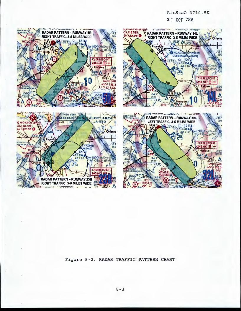
AirStaO 3710.5K
3 1 OCT 2008
RADAR PATTERN- RUNWAY 23R RIGHT TRAFFIC, 3-6 MILES WIDE .1 m --"!:Ji0",
, ........... ,, · ~ 1\ '
Figure 8-2. RADAR TRAFF I C PATTERN CHART
8-3

Runway 23R Tower Traffic Pattern
AirStaO 3710.5K
3 1 ocr 2008
Runway 4L Tower Traffic Pat
Figure 8-3. TOWER TRAFFIC PATTERN CHART
8-4

AirStaO 3710.5K
3 1 OCT 2008
W-122
Figure 8-4. PROHIBITED, WARNING, OR RESTRICTED AREA CHART
8-5
RESTRICTED R· 5306 A

I 2 BAYBORO CORRIDOR: SFCI 750
' ORIENTAL: 1500MSL-3500MSL ~ STACY: 1500MSL-3500MSL
OPEN GROUNDS: SFC-500 LOWLANDS: SFC-500 BAYCR
AirStaO 3710.5K
3 1 ocr zoos AIROPSMAN, MCAS CHERPT
04
Figure 8-5. TARGET DROPPING AND BOMBING AREA CHART
8-6

AirStaO 3710.5K
3 1 ocr 2ooa
Latitude/Longitude of reporting points:
1) Great Lake - N34 53 20.33/W77 00 05.53 2) Slocum Creek - N34 54 00.83/W76 54 52.36 3) Hancock Island- N34 54 24.79/W76 50 16.15 4) Clubfoot Creek- N34 54 18.72/W76 45 42.60 5) Golf Course - N34 56 49.67/W76 53 08 . 27 6) Bear Creek- N35 00 17.68/W76 52 01.62
Figure 8-6. HELICOPTER REPORTING POINTS
8-7


![舒康雞 HOLSEM · 2020. 4. 3. · : BA]2020/30797 : 2020/03/17 I I I I I I I I I I I I I I I I I I I I Il I Il I I I I I I I I I I I I I I I I I Il I Il I I I I Ill I I I I I I](https://img.pdfslide.net/doc/110x75/60e1a613faf52e69a51b7862/ee-holsem-2020-4-3-ba202030797-20200317-i-i-i-i-i-i-i-i-i-i.jpg)