Embed Size (px)
Citation preview

TIFFANIE NORTHRUP-ROBINSON
PLANNER II
COMMUNITY DEVELOPMENT DEPARTMENT PLANNING DIVISION 60 NORTH MAIN STREET
P.O. BOX 128 COALVILLE, UTAH 84017
PHONE (435) 336-3139 FAX (435) 336-3046 [email protected]
STAFF REPORT
To: Snyderville Basin Planning Commission From: Tiffanie Northrup-Robinson, County Planner Date of Report: February 1, 2012 Date of Meeting: Wednesday, February 8, 2012 Type of Item: Village at Kimball Junction Specially Planned Area Rezone and
Development Agreement – Work Session
The authorized representative, Bret Wahlen from Great Basin Engineering, is requesting a rezone to Specially Planned Area (“SPA”) designation and Development Agreement (“DA”) for nine lots within the existing Village at Kimball Junction Subdivision. The proposed uses include retail, office, restaurant services, a financial institution, fuel center and a fast food restaurant (Exhibit A).
Executive Summary
Three work sessions, a public hearing and meeting for further discussion and recommendation have been held regarding this SPA rezone application and DA with the Snyderville Basin Planning Commission (‘SBPC”). On January 10, 2012 the SBPC forwarded a positive recommendation to the Summit County Council (“SCC”) with a vote 5 to 1. Staff has attached the draft January minutes for your review (Exhibit B). The purpose of this work session is for the SCC to discuss and comment on compliance with the Mandatory Development Criteria and Incentive Density Criteria for developments within a Town Center and give feedback to Staff and the applicant prior to hearing the item at a public hearing, currently scheduled February 15, 2012. A.
• Project Name: Village at Kimball Junction SPA and DA Project Description
• Owner(s):Lot 4A - Fred Barth, Penrad Properties (Del Taco) Lot 1-A,B,C,D,E,F - O’Brien Kiernan Investment Co (OBK) Lot 2 and 2B - Smith’s Food and Drug Centers, Inc. (Smith’s) Lot 2A - Well’s Fargo Bank representing the John Jarman Est. (Jarmen)
• Applicant(s): Paul Hitzelberger, Del Taco Ross Varner, OBK
Page 1 of 109

2 of 9
Steve Sorensen, Smith’s Todd Fuller, Jarmen
• Authorized Rep: Bret Whalen, Great Basin Engineering • Location: Kimball Junction • Zone District: TC (Town Center) • Adjacent Uses: Commercial Retail/Office/Hotel/Residential • Existing Uses: Commercial Retail/Restaurant
B. This item is scheduled as a work session only at this time. A public hearing will be held at a later date.
Community Review
C. Section 10-2-12 of the Code states, “The purpose of the Town Center (TC) designation is to allow, at the discretion of Summit County, flexibility of land use, densities, site layout, and project design. Summit County may only use the Specially Planned Area (SPA) process to consider development within identified Town and Resort Center Zone Districts. This SPA process shall be used only when it is clearly demonstrated that, in doing so, substantial benefits will be derived by the residents of the Snyderville Basin by the application of the process. The burden rests upon the applicant to demonstrate that the project proposed for consideration under the SPA process is in the best interest of the general health, safety and welfare of Snyderville Basin Residents.
Background
The purpose of a Town Center is to provide an economically and socially viable area that reflects the mountain character of its surroundings, promotes a sense of place and community identity supporting the residents of the Snyderville Basin, separate from, but complimentary to, Park City. The Town Center is the appropriate location in the Basin for general retail uses, such as grocery stores, and for full service restaurants.” The existing Village at Kimball Junction subdivision was recorded in 1992. The plat consisted of seven (7) lots and five (5) common area parcels. Lot 1 consists of multiple tenants within the old K-Mart building (retail, restaurant), Lot 2 is the existing Smith’s, Lot 3 is owned by Chase Bank, Lot 4 is the Kimball Retail Center (retail and restaurant uses), Lot 5 is the Kimball Junction Properties Condominiums (retail, restaurant/bar, post office and general office use), Lot 6 is the Holiday Inn Express, and Lot 7 and Common Areas A and B are now part of the Redstone development. Over the course of the past year and a half the proposed Village at Kimball Junction has been reviewed at three separate work sessions, a public hearing held on November 29, 2011 and a final recommendation from the SBPC was made on January 10, 2012. The density, uses, orientation and general infill concepts of the
Page 2 of 109

3 of 9
project have been discussed at length. The SBPC indicated that they felt the application was consistent the Specially Planned Area criteria as outline in the development code and general plan within the Town Center zone and the requested density was acceptable. The current application includes the following properties and proposed uses:
Village at Kimball Junction SPA VKJ-1-A-B OBK 0.778 acres 7,774 Retail/office VKJ-1-C OBK 0.0498 acres 4,000 Retail/office VKJ-1-E OBK 0.657 acres 6,750 Retail/office VKJ-D OBK 1.09 acres 34 Workforce units VKJ-1-F OBK 0.556 acres 4,250 Retail//office/restaurant VKJ-2 Smith's 7.84 acres 11,508 Expansion VKJ-2-B Smith's 0.47 acres 3,718 Fuel center VKJ-2-A Jarmen 1.2 acres 5,000 Financial Institution VKJ-4-A Del Taco 1.32 acres 2,890 Drive thru restaurant VKJ-4-A Del Taco 0 acres 5,000 Retail/office
12.8708 acres 50,890
34 Square feet WFU (19.87 WUE)
D. D. D. D. D. D. D. D. D. D. D. D. D. D. D. D. D. D. D. D. D. D. D. D. D. D
D. General Plan Compliance
This development is in the Kimball Junction Neighborhood Planning Area according to the current General Plan, and is zoned Town Center. The goal of this planning area as stated in the General Plan; “There shall be an economically and socially viable area at Kimball Junction that reflects the mountain character of its surroundings, promotes a sense of place and community identity supporting the residents of the Snyderville Basin, separate from but complimentary to Park City.”
Kimball Junction Planning Area and Policies
Staff has attached the Kimball Junction Neighborhood Planning Area provisions from the General Plan for your review (Exhibit C). The General Plan encourages expedited approval of infill projects to enhance the economic viability within the Kimball Junction Neighborhood. The Town Center should be the focal point for living, working, shopping, entertainment, and social interaction. As you can see on the infill concept plan, it promotes development along Uinta Boulevard to help strengthen the Town Center. Additionally it encourages shared parking, strong pedestrian connections and improvements to the traffic patterns. Specifically it states that within the Kimball Junction neighborhood there should be an appropriate mix of retail and restaurant use and structures should be of a pedestrian scale. Other objectives include enhancing the streetscape, street lighting, transportation improvements and pedestrian connectivity.
Page 3 of 109

4 of 9
The applicants have taken into consideration these land use planning principles to achieve a mix of uses and create a more pedestrian friendly environment within the existing Town Center.
E.
Base density in the Town Center Zone District is 1unit/40 acres on Sensitive Lands and 1 unit/20 acres on Developable lands. The application exceeds base density and additional density must be based on compliance with the Incentive Community Benefit Criteria as outlined in Section 10-2-12 of the Code. The total acreage within this development application is approximately 19.82 acres. On that exists approximately 153,601 square feet of retail use. Below is a breakdown of approximate units per acre utilizing the 1,600 square foot unit equivalent. Although we have not adopted a unit equivalent formula, this number has been utilized on numerous applications to set a basis for SPA review.
Development Code Compliance
Project
acreage commercial s.f. commercial UE* Total UE UE/acre Total s.f.
VKJ existing 19.82 153,601 96.000625 96.00063 4.843624 153,601 VKJ SPA proposed 19.82 50,890 31.80625 31.80625 1.604755 50,890
TOTAL 204,491 127.806875 127.8069 6.448379 204,491
*based on 1,600 square feet
The Mandatory Land Use Planning Principles in the Town Center are: • Dedication and Preservation of Viewshed/Environmental Features • Consistency with the Desired Neighborhood Character • Community and Neighborhood Recreation Facilities
The amount of additional density will be based on compliance with the following criteria:
• Environmental Enhancements • Restricted Affordable Housing • Contribution to Community Trails and Parks • Exceeds Open Space Requirements for Project • Tax Base and Economic Enhancements • Compatibility with Town, Resort, Village Design
F.
The substantial items of concern throughout the review process with the SBPC were: Issues/Analysis
1. Workforce Housing allocation and location 2. Traffic Mitigation 3. Pedestrian connectivity and recreation facilities
Page 4 of 109

5 of 9
4. Highway 224 Visibility 5. Snow Storage 6. Service Provider Input
Workforce Housing (WFH) The applicant is working with Scott Loomis, Director of Mountainlands Community Housing Trust (MCHT), which is currently the County’s designee for handling the technical and maintenance aspects of future workforce housing (Exhibit D). The applicant intends to provide workforce housing per the criteria in 10-5-6 and meeting the commercial alternative as outlined in 10-5-7(4). The applicant has proposed developing the SPA in two (2) phases; however the WFH construction ready pad would be conveyed to MCHT prior to the issuance of the first certificate of occupancy for Phase 1 of the development. At the public hearing held November 29, 2011 concern was expressed about the visual impact of the WFH structure. The SPBC recommended the applicants meet with Reid Brinton representing Cottonwood Partners, the adjacent property owner in the New Park development to discuss the location of the WFH project. Mr. Brinton along with a representative from GSBS Architects, worked with the applicants to look several options reorienting the WFH on the detention site and consider the visual impacts as viewed from the Cottonwood building just east of this parcel. Exhibit E depicts the four possible locations discussed between the parties for the WFH site. Mr. Brinton has represented that they prefer option 3 as it is the least visible location as viewed from the Cottonwood Building (Exhibit F). Exhibit G prepared by GSBS Architects illustrates the view from the Cottonwood building if the WFH is located as proposed on the site plan (Exhibit H). As you can see, by flipping the orientation of the structure as requested by the SBPC, the structure is almost not visible as viewed from Cottonwood. After re-orienting the building as the SBPC had suggested at the public hearing, a condition of the recommendation given January 10, 2012 by the SBPC was to consider one other alternate location for the WFH to give some visual relief to the Holiday Inn Express and create a green space on either side of the WFH building. The applicant has considered the request and has indicated that if the building is located as option 5, the triangle detention areas would be greatly less efficient and they would not be able to achieve volumes that we previously had designed and which are necessary to meet the requirements for storm water (Exhibit I). The applicants have continued to work with the Engineer’s office regarding the detention area not only to confirm that it can be constructed to acceptable capacity, but also to create a useable green space for the WFH component. Additional, Mr. Wilkerson has indicated that the Option 3 configuration for the Workforce Housing site is ideal as illustrated based on existing constraints of the site. As proposed the detention basin
Page 5 of 109

6 of 9
would also serve as open recreation/green space for the WFH residents and surrounding uses. Traffic Mitigation A primary concern for development in this area has been the existing traffic congestion and poor pedestrian circulation in this area. It was essential to address how the additional density would affect the current traffic pattern. The applicant has provided a traffic impact analysis that has been reviewed extensively by Kent Wilkerson from the County Engineers office. Several areas will fall below acceptable Level of Service (LOS) standards even without the project. The project will accelerate below standard conditions; however the applicants are providing mitigations beyond its impacts. (Full traffic report available upon request). The proposed expansion would only account for approximately 9% of the impact to the major intersections. The applicants have agreed to work in conjunction with the County to help implement roundabouts at the North and South ends of Uintah Way near Wendy’s and Redstone respectively. Mr. Wilkerson notes in his memorandums, the construction of these roundabouts are currently part of the Snyderville Basin Transportation Master Plan (SB-TMP). Not only would the improvements be a community benefit for the project, but a benefit that would extend to the regional area as well. The applicants, County Engineering and the Public Works Director have been working diligently to find a funding mechanism that would work for all parties involved to ensure that the two roundabouts could be constructed in a timely manner so that the levels of service could be maintained at an acceptable level. The details have been outline in both the proposed Development Agreement and Mr. Wilkerson’s memorandum (Exhibit J). As written, it is anticipated that with appropriate funding the North roundabout at the Ute/Uintah Way is anticipated to be completed by 2012 and the South roundabout at the Newpark Boulevard/Uintah Way would be completed in 2013. The County has also involved the adjacent landowners outside the project area (Wendy’s, Kimball Plaza, Silver Mountain Building, and Redstone.) Securing the needed right-of-way is currently in process.
Fully inclusive costs for both roundabouts are anticipated to be around $1,500,000 for the mitigations. In order to ensure funding for the roundabouts, the applicants have committed to paying all the Transportation Impact Fees for Phase 1 of the new development prior to the issuance of the first building permit. Phase 2 would be required to pay the impact fees prior to a building permit being issued within that phase or prior to the construction of the Newpark roundabout, whichever comes first. The County has also received approval for $600,000 from the Council of Governments (COG) from the Corridor Preservation Fund that would be used to purchase right of way from all parties from within and outside of the development in 2012 and 2013. All property
Page 6 of 109

7 of 9
owners within the development have committed to turn the funds from the ROW acquisition back to the County to utilize for the construction of the roundabouts. The remaining balance as projected is $240,000. Staff recommended a 41% Developer - 59% County split on the remaining funds needed as additional community benefit, however, this was not implemented by the applicants.
Medians are proposed from SR-224 east for approximately 300’ on both Ute and
Newpark Boulevards. The roundabouts will also help provide better area circulation that would otherwise be restricted due to the medians. No left turn will be allowed out of the main entrance to Redstone nor the proposed Del Taco. Traffic will turn right and then do a u-turn with the roundabout. Additionally, Mr. Wilkerson has reviewed the development agreement, subdivision plat and construction drawings that were provided by the applicant, as well as interim submittals and other supporting documents. Mr. Wilkerson had indicated that with the traffic mitigations and supporting elements of the development agreement, the subdivision plat and construction drawings can all meet the requirements and standards of the County. Significant enhancements occur to this otherwise poor pedestrian circulation area. Other improvements to meet the transportation objectives of the General Plan include joint use of parking areas and a transit stop adjacent to Smith’s. Pedestrian Connectivity/Recreation Facilities The applicants have been working closely with Kevin Callahan from Summit County Public Works (Exhibit K) and Kent Wilkerson from Summit County Engineering department regarding traffic and connectivity concerns. The Kimball Junction Walkability Study in 2008 identified some critical connectivity that needed to happen in this area (Exhibit L). The applicant has utilized this study to complete many of the necessary connections within this neighborhood (Exhibit M). The connectivity and walkability within the area is a major improvement and meets or exceeds the goals and objectives of the Kimball Junction Walkability Study. Senta Beyer from the Snyderville Basin Special Recreation District has also been in contact with the applicant throughout the review process to address the connectivity and recreation component of the plan. Although the SBSRD does not have any trails on the Trails Master Plan in this area, they have expressed support of the additional connectivity that will be provided as it is critical to creating a more pedestrian friendly center. The SBPC conditioned their recommendation that the applicant work with the SBSRD to ensure that the trails are properly designed and make the proper connections. Ms. Beyer met with the applicant on January 19, 2012 to discuss the proposed design and has submitted her recommendations and support for the proposal (Exhibit N).
Page 7 of 109

8 of 9
The applicants are also proposing several green space/pocket parks throughout the development to accommodate walkers and bicyclist alike. The addition of bike racks throughout the development and the bicycle “fix-it” area has enhanced the area as a trailhead location. Highway 224 Visibility The general plan suggests that minimum development should occur within the highway corridor to preserve the viewsheds as you enter the Kimball Junction neighborhood. The SBPC has been concerned about the visibility of the proposed Del Taco located on the corner of Ute Boulevard and Highway 224. At the request of the SBPC the applicants looked at relocating the Del Taco further east and realigning Sagewood Drive. The applicants considered two other options, but it appears that neither option would allow for appropriate circulation and queuing distances necessary. County Engineer Kent Wilkerson concurs with the applicant’s analysis of the adjusted potential sites. The applicants did modify the architecture as requested by the SBPC to lower the height of the roof line most visible from Highway 224 (Exhibit O). Snow Storage, Removal and Maintenance Along with the snow storage areas depicted on the final site plan, the applicants have placed a note on the subdivision plat, included language in the DA and also in the amended CC&R’s that requires each individual property owner to maintain their sidewalks at all times (Exhibit P). Parking lot snow storage may only be temporary and then must be removed to the open space or detention areas. Staff is comfortable that these measures will allow the County to enforce the snow removal if it were to become an issue. Service Providers Staff has received comments from service providers regarding the propose SPA (Exhibit Q). Many of them are will-serve letters, including: · Rocky Mountain Power · Snyderville Basin Water Reclamation District · Summit Water Distribution · Park City Fire District These providers have informed Staff that the will-serve letters are preliminary and conceptual, stating that the utilities are able to provide service upon compliance with more stringent requirements for final approval. Some of these requirements may include Line Extension Agreements, installing larger pipes to increase capacity, providing cost estimates and needs analysis, and finalizing detailed plans. F. Staff recommends that the SCC discuss the Village at Kimball Junction SPA Rezone and
Recommendation
Page 8 of 109

9 of 9
DA proposal and provide input or additional feedback on the development compliance with the Town Center Neighborhood and SPA requirements. Please specify any specific modifications or recommendations that the Council would like to see addressed prior to the public hearing on February 15, 2012. Attachment(s): Exhibit A – Proposed Plat/Site Plan Exhibit B – Draft Meeting Minutes, January 10, 2012 Exhibit C – Kimball Junction Neighborhood Plan Exhibit D – Memorandum Scott Loomis, Mountain Land Housing Trust Exhibit E – Optional locations for workforce housing Exhibit F – Letter from Reid Brinton, Cottonwood Partners Exhibit G – Visual analysis from Cottonwood buildings Exhibit H – Workforce Housing Site Plan Exhibit I – 5th optional location Exhibit J – Kent Wilkerson Memorandums Exhibit K – Kevin Callahan Memorandum Exhibit L – Walkability Plan Exhibit M – Sidewalk/Trail plan Exhibit N – Senta Beyer, SBSRD Exhibit O – Del Taco Elevation Exhibit P – Snow Storage Exhibit Q – Service Provider Comments Exhibit R – Draft Development Agreement
Page 9 of 109

Exhibit APage 10 of 109

EXHIBIT B - 1Page 11 of 109

EXHIBIT B - 2Page 12 of 109

EXHIBIT B - 3Page 13 of 109

EXHIBIT B - 4Page 14 of 109

EXHIBIT B - 5Page 15 of 109

EXHIBIT B - 6Page 16 of 109

EXHIBIT B - 7Page 17 of 109

EXHIBIT B - 8Page 18 of 109

EXHIBIT B - 9Page 19 of 109

EXHIBIT C1Page 20 of 109

EXHIBIT C2Page 21 of 109

EXHIBIT C3Page 22 of 109

EXHIBIT C4Page 23 of 109

EXHIBIT C5Page 24 of 109

EXHIBIT C6Page 25 of 109

EXHIBIT C7Page 26 of 109
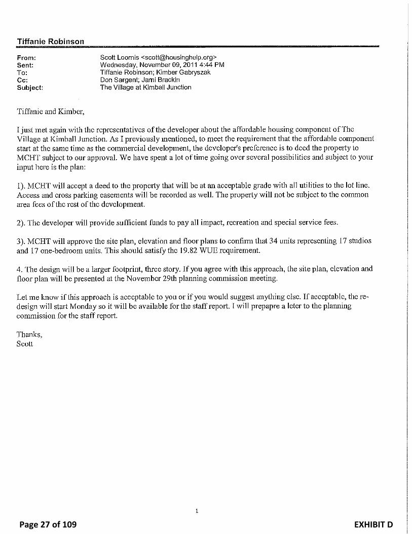
EXHIBIT DPage 27 of 109

EXHIBIT HPage 28 of 109

EXHIBIT HPage 29 of 109

Exhibit EPage 30 of 109

EXHIBIT F1Page 31 of 109

EXHIBIT F2Page 32 of 109

EXHIBIT F3Page 33 of 109

EXHIBIT F4Page 34 of 109

EXHIBIT F5Page 35 of 109

EXHIBIT G1Page 36 of 109

EXHIBIT G2Page 37 of 109

EXHIBIT G3Page 38 of 109

EXHIBIT HPage 39 of 109

EXHIBIT I1Page 40 of 109

EXHIBIT I2Page 41 of 109

County Engineer Derrick A. Radke, P.E.
MEMORANDUM Date: September 19, 2011 To: Tiffanie Northrup, County Planner From: Kent S. Wilkerson, P.E. Engineer II Re: Village at Kimball Junction – SPA Review 1
This is the first full review of the SPA application and associated documents. Generally the project is acceptable, though many details and considerations are needed as follows: 1. Traffic Report: (generally acceptable, mitigation proposed / required, implement SBTMP) The County has worked with the applicants in determining Level of Service (LOS) and probable solutions to traffic issues. The County Code requires we maintain an LOS of County Roads ‘C’ and State Roads of ‘D’. The code is a general statement and the project traffic report looks deeper as recommended in the Snyderville Basin Transportation Master Plan (SBTMP), which includes individual turn movements and time of year adjustments.
1.1 Currently: All intersections meet the standards with the exception of individual movements:
- Uintah Way / Newpark: North Bound and South Bound Left - Ute / SR-224 : East bound left, West through, North Left, South Left - Newpark / SR-224: West left, West through, North through
1.2 Adding the subject project to the current traffic adds the following to the “below
standards list” and exacerbates the above. - Ute / Uintah Way: North bound left - Ute / SR-224: Over all intersection
1.3 Projection of the traffic to 2030 creates numerous additional below standard conditions in
addition to the above: This analysis assumes SR-224 having been expanded to 3-lanes each way per the SBTMP
- Smiths 4-way stop, Kimball’s Plaza / Wendy’s west access, SR-224/Newpark
1.4 Solutions proposed: The project implements and enhances the SBTMP. The primary traffic impact mitigation feature is the addition of two-roundabouts North and South of the project at Ute/Uintah Way and Newpark / Uintah Way. Bill Baranowski, a known roundabout professional, has been retained by the developer and has provided specific reviews of the proposed roundabout (see the end of the
EXHIBIT J SEP 19 2011 -1Page 42 of 109

VKJ – SPA
September 19, 2011
Page 2 of 7
traffic report). No specific construction drawings have been provided and additional details will need to be addressed below.
SBTMP implementation: - The primary change required in the long range analysis (2030) is conversion of SR-
224 to 3 travel lanes each direction. This is required with or without the project and is in UDOT’s Long Range Plan. Summit County continues to work with UDOT on the details as we have specific needs in HOV and Transit services currently.
- Ute / Uintah Way (North Roundabout) is specifically listed in the SBTMP. - Newpark / Uinta Way was considered comparable to a driveway and not specifically
listed in the SBTMP. - In very long range planning (2030) an off grade intersection is listed at Ute / SR-224.
This project’s traffic study verifies the LOS F at this intersection and the need for the improvement. This need occurs independent of the project, but the project needs to acknowledge its implementation as it has long-range impacts.
- Connectivity, primarily pedestrian sidewalks, is noted as a great need within the subject area by the SBTMP. The SPA provides a significant number of the identified needs.
1.5 Timing of improvements: No coordination of improvements is proposed. However,
based on the above, no building permits are recommended unless additional transportation capacity is provided in advance or concurrent with the development of the project.
2 Development Agreement (DA): (rework required)
2.1 Traffic: The agreement begins the structure of a community benefit, but places an
immediate burden on the County without a solution to fund the additional traffic. I had discussed this with the applicants and the need of additional capacity. The County does not currently have funds to construct within the projects timeframe. In the draft DA, the Roundabout intersections will need to be improved by the County within two years. The Development Agreement does state land donation, but without a fair allocation of the internal land costs. The SPA applicants could do fair allocation internally. The separated nature of the applicants does not document respective interests. Exhibit 1is one method for initial consideration based on expected traffic impact. In summary:
i. The project expects to produce 261 peak hour trips
ii. The current fee rate is $1,924.38 per peak hour trip iii. Total fees expected from the project (267 trips x $1,924.38 /trip) = $514,473
($0.5M) iv. Roundabout costs = $1,500,000. This does include all land acquisition including
land inside the VKJ Plat as illustrated. See attached cost estimates (Exhibit 2).
EXHIBIT J SEP 19 2011 -2Page 43 of 109

VKJ – SPA
September 19, 2011
Page 3 of 7
v. Subject to appraisal, land within the VKJ Plat is roughly valued at $239,250.
vi. Estimated cash needed is ($1,500,00 – $239,250) = $1,260,750 ($1.2M) vii. As written – Summit County would need to fund/front the construction at the
$1.2M and in time receive $0.5M in impact fees leaving an end balance of $985,527 ($0.9M). The County cannot be compelled to construct within any time constraint.
viii. The $1.2M and $0.9M is clearly a County funding issue to be ultimately determined by the County Council. This is a probable discussion in executive session with the Council as this is land acquisition. The primary concern is expectation of County restructuring all capital plans to accommodate the required LOS (DA Section 7.6)
ix. My recommendation to the applicants was a Credit / Pioneering Agreement to fund the project. (Reconsider DA Section 4.2). Right-of-way is provide but where is the compelling “community benefit”?
x. Slope easements need to be included in the DA.
2.2 Improvements timing: In addition to the above traffic improvements, pedestrian connectivity (sidewalks) is indicated to be completed in phases, as the parcels are completed. One of the outstanding project benefits is connectivity of the area. As stated in the draft agreement, these may not occur for many years leaving a fragmented / unsustainable pedestrian network. Though some of the walks are supporting individual buildings, others are more core and need to be provided and maintained on a more definite time frame. Section 7 needs to provide a more complete phased implementation plan or direct completion of the connectivity.
2.3 Caution, Section 4.3 provides an escape from the SPA / DA requirements. Certain benefits of the SPA need to be provided upon granting of the zone, such as: connectivity, traffic capacity, etc.
2.4 No Construction Mitigation plan provided (Section 4.5) but may be provided with each
building.
2.5 Service provider approval is needed concurrent with the SPA as services are modified with the general project. (Section 4.6)
2.6 Other DA sections from similar agreements should be included in this DA. One
example, the County requires a separate Development Improvements Agreement (DIA) with each project phase. This should be acknowledged.
EXHIBIT J SEP 19 2011 -3Page 44 of 109

VKJ – SPA
September 19, 2011
Page 4 of 7
3 Project Plat: (Correct and re-review required) Graphic Presentation does not match Boundary one point: N 86° 31’ 32” E vs N 86°31’52”E – Northwest call along Ute Blvd. Other revisions:
a. Adjacent plats need to be shown or referenced: Kimball Plaza, Redstone, etc. as they are impacted.
b. Provide a vicinity map. c. Provide monuments to be set. d. Book and page of easements need to be provided. e. Off site work and easements should be referenced. These need to be existing and
recorded for the project, such as on Lot 4-A work and on Lot 3-4. f. Internal easements are needed, such as storm drain from one parcel to next like
Lot4-A through lot 2. g. Label Uinta Way as a private road. h. Are there other cross access easement considerations? i. Verify petroleum line easement on the north side j. Signature Blocks:
i. Owners dedication may need to be a second sheet based on multiple interests. These need to include consent of mortgagors, lien holders, others.
ii. Summit Water is a Company – not a District in the signature blocks. iii. The County is Council not Commission. iv. Public Works ‘Director’.
k. Recommend sidewalk maintenance as a plat restriction. l. Provide a plat note that center medians are to be constructed from SR-224 on both
Newpark and Ute Boulevards. m. Verify proposed public right-of-way locations to be dedicated. Currently proposed
dedication is to the rear of the roundabout islands as I recommended.
4 Construction Drawings: (Correct & re-review required) Many details of the construction drawings need modification – though this is a lengthy list, none appear fatal in design. Also, bonding and cost estimates may be appropriate for items of general interest such as Roundabouts, connectivity, common landscape, sidewalk maintenance, etc.
4.1 General Corrections: Check all sheets a. City Standards are referenced – should be County Standard or Sewer –
Snyderville Basin Water Reclamation District or Water – Summit Distribution Water Co.
b. All service providers need to provide concurrence. Some of the utility relocations are significant.
EXHIBIT J SEP 19 2011 -4Page 45 of 109

VKJ – SPA
September 19, 2011
Page 5 of 7
c. Erosion Control plans are not complete. See site plan requirements check list. i. Construction management plans are part of the site plan requirements
check list. Need to illustrate staging of improvement as applicable. ii. Drawings allow 60 days to stabilize – Ordinance 381A (Summit County
STORM WATER POLLUTION PREVENTION AND EROSION CONTROL) provides only 14 days.
d. Petroleum line rear of Smiths is crossed – work per the line operators standards. (note it at each applicable location)
e. Hours of construction are referenced in the drawings – Summit County Noise Ordinance needs to control – unless a variance is granted.
f. Landscape plans are not totalized, this is likely okay for a draft but we need to verify intersection sight distance for the Roundabouts – are restrictions / easements needed?
g. Geotechnical investigation is pending. General specifications are needed currently.
4.2 Detail corrections:
a. Smith Expansion i. Should there be a sheet C3.2 – possibly okay?
ii. ADA ramp needed east end of the mid parking lot crossing. iii. C1.1 scales at 38’ for nose to nose parking - typically 40’ is required. iv. NW corner of the financial pad – non-directional ADA ramp v. Parking lot islands have hard 90° corners- recommend filets or rounds
vi. C2.1 near truck dock – ADA ramp needed vii. C2.1 new drive –truck dock access is not to current drive standards –as
this is a historic delivery area – likely okay N/A b. Financial Institution
i. NW corner – orient the ADA ramps to receiving ramp so visually impaired are directed.
ii. C2.1 – is the grading correct – teller / floor height (97.00) 3’ above the car height (+/-94.0)
iii. C5.1 – silt fence is on the uphill side of the parking lot. c. Del Taco
i. 16’ retailing wall – is there a side yard setback requirement? ii. There is off site work as mentioned generally above. The sewer and storm
drain both are accessed via Lot 3-4. d. Retail Pad A, B, C & F
i. Check roundabout sight distances – general note above. ii. Non-directional ADA ramp southeast of pad C needs to match others.
e. Retail Pad E i. Significant offsite improvements – access / approval required. This site
includes parking stall reconfiguration, access and landscape.
EXHIBIT J SEP 19 2011 -5Page 46 of 109

VKJ – SPA
September 19, 2011
Page 6 of 7
ii. Utility easements exist along the north west side. Does this affect the block wall and the pergola illustrated?
f. Fuel Center i. Non-directional ADA ramp.
ii. No building set back provided. iii. Text conflicts on the grading plan near the fuel tank. iv. What are the other state provisions for the Underground Storage Tank? v. Provide enhanced SWP3 plan details associated with fuel delivery. See
specifics associated with Ordinance 381A. g. Affordable Housing
i. The primary concern is housing interaction with truck traffic and the truck dock. This affects the access and the general area circulation and safety. Please justify the design.
ii. Related to the above, the access to Highland Drive is new. Safety and function relative to the truck dock area is a concern.
iii. Storm drain overflows to Newpark’s landscape and Highland Drive – acknowledgement by Newpark is recommended. It is likely an improvement of existing, which is directly into the Cottonwood 1 building. However, the pond size is modified.
iv. A geotechnical report is critical for the site. Construction is proposed on 8’ of fill.
5 Storm Drain: ( additional information required) It appears that the Storm Drain Report is mostly a review and implementation of the prior report. If the overall hard surface area is reduced via this project, the prior report is acceptable.
- Need to verify historic verses and proposed surface area totals. - The calculations do not illustrate improvements to the “current standards” See
ordinance 381A – no ground water recharge, TSS removal, etc. are provided. - There are hydrophilic species currently in the current pond. Does this need to be further
addressed. Clearly there is some dependency of the manmade pond area. - We need details of calculations such as: orifice size, construction details, etc. - Calculations need to be provided for the fuel center oil-water separator in accord with
Ordinance 381-A (see page A-18) 6 Other
- Way finding: A discussion with the applicant proposed a common sign plan giving the General area a scene of place similar to: (Newpark, Redstone or Tanger) covering many shops. A common sign plan was not provided.
- Sidewalk Maintenance: this is required currently, but is not enforced. Guarantee of maintenance to a specified standard is needed.
EXHIBIT J SEP 19 2011 -6Page 47 of 109

VKJ – SPA
September 19, 2011
Page 7 of 7
- Cross access: agreement to include construction / modification / site approvals. - Petroleum Line Crossing: Listed herein mostly as a caution, crossing and working
around the petroleum line requires care and approval as appropriate.
7 Community Benefits: (for consideration) - Walkablity –This project fills in the most unfriendly pedestrian area of the Kimball
Junction. Many of the projects were on the long-range plan. - This project provides a re-analysis and implementation of the SBTMP. Currently we look
only to the 2030 planning year but will soon need to look to the 2040 consistent with the Snyderville Basin General Plan and the UDOT Long Range Plan.
- Depending on the structure of roundabout implementation, they could be the greatest community benefit of the project. Currently right-of-way is significant
CC: Bret Wahlen, Great Basin Engineering, Project Engineer Kevin Callahan, Public Works Director
file (S:\PROJECTS\2010\CD10\VILLAGE AT KIMBALL JUNCTION - SMITHS DEL TACO ETC\SPA REVIEW 1.DOCX)
EXHIBIT J SEP 19 2011 -7Page 48 of 109

Possible Cost Allocation Based on Trip Generation – Benefit Table:
$
1,924.38 $ 1,500,000
Impact Fee
Rate
Cost of **
Roundabout
s
Parcel Project Added Units
Estimated
trips/unit
Shared
Trips
External
trips pass by %
Total
system
trips % of total
Proportionate
total
community
benefit **
land value
provided -
estimate Needed funding
Proportionate
Community benefit -
roundabouts only
(needed land-fee)
2 Smith Expansion 11508 /1000 SF 10.5 20% 96.67 36% 61.87 * $ 119,056 23.14% $ 347,120 $ 118,360 $ 228,760 $ 228,064
2B Smith Fuel Center 8 Positions 13.38 20% 85.63 56% 37.68 $ 72,507 14.09% $ 211,402 $ 211,402 $ 138,895
4A Del Taco 2890 /1000 SF 33.84 20% 78.24 50% 39.12 $ 75,280 14.63% $ 219,487 $ 219,487 $ 144,207
4A 4a future retail 5000 /1000 SF 3.73 20% 14.92 34% 9.85 $ 18,950 3.68% $ 55,250 $ 55,250 $ 36,300
1D Affordable Housing 32 Units 0.62 20% 15.87 0% 15.87 $ 30,544 5.94% $ 89,054 $ 89,054 $ 58,510
2A Mtn Am. Credit Un. 5000 /1000 SF 27.41 20% 109.64 47% 58.11 $ 111,824 21.74% $ 326,035 $ 45,650 $ 280,385 $ 214,211
1A Retail Pad A 3637 /1000 SF 3.73 20% 10.85 34% 7.16 $ 13,784 2.68% $ 40,189 $ 22,825 $ 17,364 $ 26,405
1A Retail Pad B 4137 /1000 SF 3.73 20% 12.34 34% 8.15 $ 15,679 3.05% $ 45,714 $ 22,825 $ 22,889 $ 30,035
1C Retail Pad C 4000 /1000 SF 3.73 20% 11.94 34% 7.88 $ 15,160 2.95% $ 44,200 $ 44,200 $ 29,040
1F Retail Pad D 4250 /1000 SF 3.73 20% 12.68 34% 8.37 $ 16,107 3.13% $ 46,963 $ 46,963 $ 30,855
1E Retail Pad E 6750 /1000 SF 3.73 20% 20.14 34% 13.29 $ 25,582 4.97% $ 74,588 $ 29,590 $ 44,998 $ 49,005
totals 468.93 267.34 $ 514,473 100.00% $ 1,500,000 $ 1,260,750 $ 985,527
* reminder of 50,000 credit
retained ** includes project land - see cost est
from prior land purchase balance
EXHIBIT J SEP 19 2011 -8Page 49 of 109

EXHIBIT J SEP 19 2011 -9Page 50 of 109