Embed Size (px)
Citation preview
-- .---.-,w- " ' PROGRAM Sffl.:
January 2, 2019
CERTIFIED MAIL
Ms. Constance A. Jones Superfund Division U.S. Environmental Protection Agency
Region 4 Atlanta Federal Center 61 Forsyth Street, SW Atlanta, Georgia 30303-8960
Mr. Randy C. Young State of Tennessee Department of Environment and Conservation Division of Remediation - Oak Ridge 761 Emory Valley Road Oak Ridge, Tennessee 37830-7072
Dear Ms. Jones and Mr. Young:
........ - ,_,.,,__._____.
?PDJf.CT
TRANSMITTAL OF THE SITE PREPARATION PLAN FOR THE PROPOSED ENVIRONMENTAL MANAGEMENT DISPOSAL FACILITY FOR COMPREHENSIVE ENVIRONMENTAL RESPONSE, COMPENSATION, AND LIABILITY ACT OAK RIDGE RESERVATION WASTE DISPOSAL, OAK RIDGE, TENNESSEE (DOE/OR/01-2805&D1)
Enclosed please find the identified number of copies of the subject document and compact disk for your review. The enclosed document was prepared in accordance with a tri-party agreement between the Oak Ridge Office of Environmental Management, Tennessee Department of Environment and Conservation, and the U.S. Environmental Protection Agency to focus on limited site preparation. Design documents will be scheduled and submitted for approval following the signing of the Record of Decision.
CERTIFIED - RETURN RECEIPT REQUESTED (JONES 7009 2820 0001 9922 5369) (YOUNG 7009 2820 0001 9922 5376)
___ __.. .

.•
Constance A. Jones/Randy C. Young -2- January 2, 2019
TRANSMITTAL OF THE SITE PREPARATION PLAN FOR THE PROPOSED ENVIRONMENTAL MANAGEMENT DISPOSAL FACILITY FOR COMPREHENSWE ENVIRONMENTAL RESPONSE, COMPENSATION, AND LIABILITY ACT OAK RIDGE RESERVATION WASTE DISPOSAL, OAK RIDGE, TENNESSEE (DOE/OR/Ol-2805&Dl)
If you have any questions or if we can be of any further assistance, please contact Brian Henry at (865) 241-8340 or John Michael Japp at (865) 241-6344.
Enclosures: 1. Document 2. CD
EPA: 1 (Enclosure 1), 2 (Enclosure 2) TDEC: 2 (Enclosure 1), 1 (Enclosure 2)
cc w/enclosure 1: SSAB
Sincerely,
!!- ·1,.,:,----
~rian T. Henry Portfolio Federal Project Director
Mic~~ eral Facility Agre ent Project Manager
Rhonda Butler, Value Added Solutions, K-1007, MS-7243, plus 1 copy of Enclosure 2
cc w/o enclosures: Carl Froede, EPA Region 4 Susan DePaoli, Pro2Serve Brad Stephenson, IDEC Julie Pfeffer, UCOR Tanya Salamacha, UCOR [email protected] Pat Halsey, EM-942
CERTIFmD-RETURN RECEIPT REQUESTED (JONES 7009 2820 0001 9922 5369)
(YOUNG 7009 2820 0001 9922 5376)

DOE/OR/01-2805&D1
Site Preparation Plan for the Proposed Environmental Management Disposal Facility for Comprehensive
Environmental Response, Compensation, and Liability Act Oak Ridge Reservation Waste
Disposal, Oak Ridge, Tennessee


DOE/OR/01-2805&D1
Site Preparation Plan for the Proposed Environmental Management Disposal Facility for Comprehensive
Environmental Response, Compensation, and Liability Act Oak Ridge Reservation Waste
Disposal, Oak Ridge, Tennessee
Date Issued—December 2018
Prepared for the U.S. Department of Energy
Office of Environmental Management
URS | CH2M Oak Ridge LLC under contract DE-SC-0004645

This page intentionally left blank.

iii
CONTENTS
TABLES ....................................................................................................................................................... v
FIGURES ...................................................................................................................................................... v
ACRONYMS .............................................................................................................................................. vii
1. INTRODUCTION .................................................................................................................................. 1
2. SITE DESCRIPTION ............................................................................................................................. 3 2.1 GEOLOGIC SETTING OF THE CBCV SITE ............................................................................. 3 2.2 BORROW MATERIAL REQUIREMENTS ................................................................................ 3 2.3 EXISTING UTILITIES ................................................................................................................. 7
3. PROJECT DESCRIPTION .................................................................................................................. 11 3.1 ROAD REROUTES .................................................................................................................... 11 3.2 UTILITIES EXTENSIONS ........................................................................................................ 14
3.2.1 Electrical Power ........................................................................................................... 14 3.2.2 Water ........................................................................................................................... 14 3.2.3 Voice and Data Communications ................................................................................ 14
3.3 BORROW AREA DEVELOPMENT ......................................................................................... 15 3.3.1 Borrow Area Characterization ..................................................................................... 15 3.3.2 Borrow Area Design and Construction ........................................................................ 15
4. DESIGN CRITERIA AND CODES .................................................................................................... 17 4.1 DOE ORDERS, GUIDANCE, AND POLICIES ........................................................................ 17 4.2 NATIONAL CONSENSUS STANDARDS AND CODES ....................................................... 17
5. ARARS CROSSWALK ....................................................................................................................... 21
6. WASTE MANAGEMENT .................................................................................................................. 25 6.1 ROAD REROUTES .................................................................................................................... 25 6.2 UTILITIES EXTENSIONS ........................................................................................................ 28 6.3 BORROW AREA DEVELOPMENT ......................................................................................... 28
7. PROJECT ORGANIZATION AND SCHEDULE .............................................................................. 29 7.1 PROJECT ORGANIZATION ..................................................................................................... 29
7.1.1 OREM .......................................................................................................................... 29 7.1.2 Regulators .................................................................................................................... 30 7.1.3 UCOR .......................................................................................................................... 30
7.2 PROJECT SCHEDULE .............................................................................................................. 30
8. REFERENCES ..................................................................................................................................... 31
APPENDIX A. APPLICABLE OR RELEVANT AND APPROPRIATE REQUIREMENTS CROSSWALK TABLES ................................................................................................................... A-1

iv
This page intentionally left blank.

v
TABLES
Table 1. DOE Orders, guidance, and policies applicable during ESP ........................................................ 17 Table 2. Summary of ARARs for EMDF ESP ........................................................................................... 22 Table 3. Summary of waste stream characterization during ESP activities ................................................ 26
FIGURES
Fig. 1. Proposed EMDF location .................................................................................................................. 4 Fig. 2. CBCV site topographic setting .......................................................................................................... 5 Fig. 3. General geology of the Bear Creek Valley ........................................................................................ 6 Fig. 4. Proposed borrow area locations ......................................................................................................... 8 Fig. 5. Proposed borrow areas in CBCV ....................................................................................................... 9 Fig. 6. Proposed Central Borrow Area on Chestnut Ridge ......................................................................... 10 Fig. 7. EMDF conceptual site layout .......................................................................................................... 12 Fig. 8. Proposed roadway realignments and existing utilities in CBCV ..................................................... 13 Fig. 9. EMDF project organization ............................................................................................................. 29

vi
This page intentionally left blank.
vii
ACRONYMS
ARAR applicable or relevant and appropriate requirement ASCE American Society of Civil Engineers ASME American Society of Mechanical Engineers AWS American Welding Society AWWA American Water Works Association BCK Bear Creek kilometer BCV Bear Creek Valley CBCV Central Bear Creek Valley CCL compacted clay liner CERCLA Comprehensive Environmental Response, Compensation, and Liability Act of 1980 CFR Code of Federal Regulations CO Contracting Officer D Drainage DOE U.S. Department of Energy EMDF Environmental Management Disposal Facility EMWMF Environmental Management Waste Management Facility EPA U.S. Environmental Protection Agency ESP Early Site Preparation FFA Federal Facility Agreement FSP Field Sampling Plan IEEE Institute of Electrical and Electronics Engineers LLW low-level (radioactive) waste NFPA National Fire Protection Association NT North Tributary OREM Oak Ridge Office of Environmental Management ORR Oak Ridge Reservation PPE personal protective equipment PVC polyvinyl chloride RCRA Resource Conservation and Recovery Act of 1976 RI/FS Remedial Investigation/Feasibility Study ROD Record of Decision SOW statement of work SPP Site Preparation Plan TDEC Tennessee Department of Environment and Conservation TM technical memorandum UL Underwriters Laboratories UPF Uranium Processing Facility Y-12 Y-12 National Security Complex

viii
This page intentionally left blank.

1
1. INTRODUCTION
The mission of the U.S. Department of Energy (DOE) Oak Ridge Office of Environmental Management (OREM) is to decommission and demolish facilities and conduct remedial actions under the Comprehensive Environmental Response, Compensation, and Liability Act of 1980 (CERCLA) on the Oak Ridge Reservation (ORR) in Oak Ridge, Tennessee. This effort requires an estimated 2.2 million cy of additional landfill disposal capacity for the disposal of wastes from CERCLA cleanup actions. As such, the Environmental Management Disposal Facility (EMDF) has been proposed on an approximately 70-acre tract in Central Bear Creek Valley (CBCV).
The proposed EMDF consists of the disposal facility, wastewater storage/treatment, support facilities, and borrow areas. Design and construction of these facilities will occur following approval of the CERCLA Record of Decision (ROD). Early Site Preparation (ESP) activities are being proposed to expedite the project and avoid a gap in disposal capacity for CERCLA wastes on the ORR. These ESP activities include rerouting the existing Haul Road and Bear Creek Road; extending water, power, and communications utilities to the site; partially demolishing an abandoned 161 kV power line; and developing soil borrow areas.
By tri-party agreement between OREM, the Tennessee Department of Environment and Conservation (TDEC), and the U.S. Environmental Protection Agency (EPA), this Site Preparation Plan (SPP) is serving in place of typical CERCLA remedial design and action documentation under the Federal Facility Agreement for the Oak Ridge Reservation (FFA) (DOE 1992) due to limited scope implementation. Although conducted under CERCLA in support of developing the landfill, this work is independent of the landfill or treatment plant design and construction and is not associated with any of the project features that would be used to control contamination. Therefore, the FFA parties have determined that the SPP is the most appropriate CERCLA documentation. Agreement was reached that work on this document could commence once the Proposed Plan was released to the public and the document could be finalized ahead of the ROD. A primary purpose of this document is to identify applicable or relevant and appropriate requirements (ARARs) and discuss how these requirements will be met during ESP activities. In addition, a summary of conceptual design criteria and activities related to these tasks, along with the projected schedule for completion and project organization chart, are included in this plan.

2
This page intentionally left blank.

3
2. SITE DESCRIPTION
The EMDF project, a DOE OREM landfill design and construction project on the ORR in Oak Ridge, Tennessee, will be used for the disposal of qualifying CERCLA waste generated from ORR cleanup activities. Site 7c (Fig. 1) has been identified in CBCV as a potential location for EMDF, approximately 2 miles west of the current disposal facility, the Environmental Management Waste Management Facility (EMWMF). The conceptual layout of the new landfill places the disposal cells on the south flank of Pine Ridge.
2.1 GEOLOGIC SETTING OF THE CBCV SITE
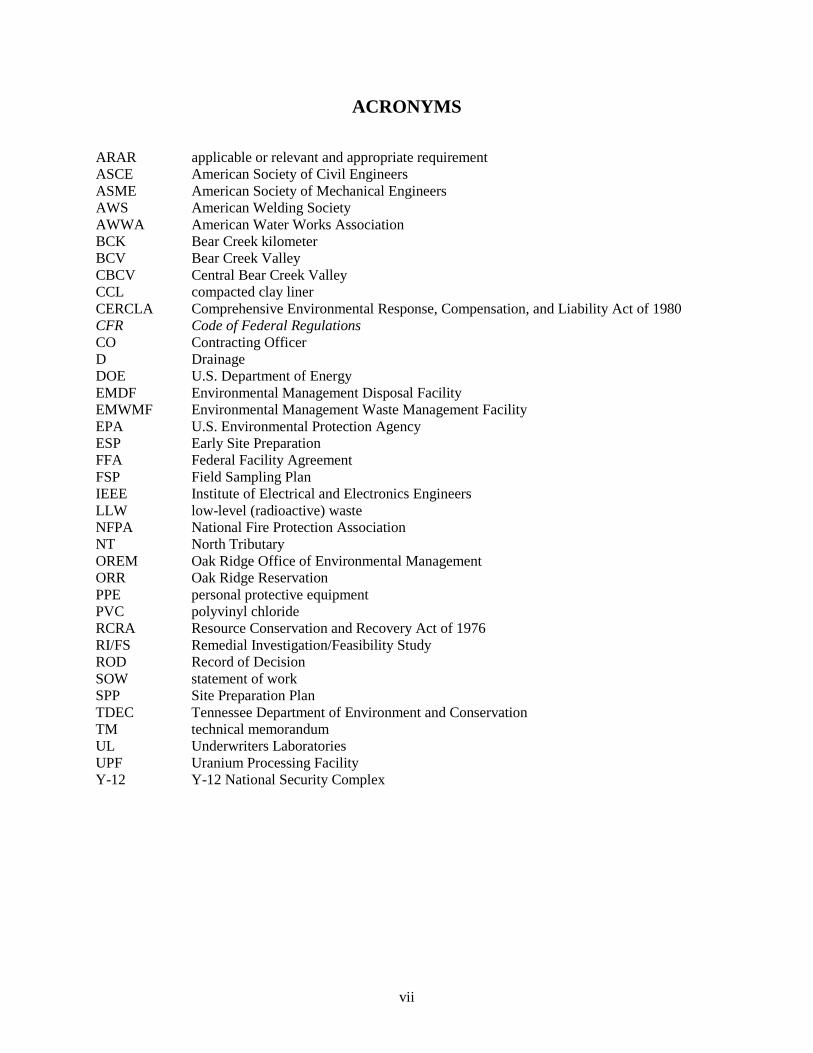
The CBCV site is situated within an upland area located between north-south trending valleys of North Tributary (NT)-10 and NT-11. Other streams and drainages within the site are Drainage (D)-10 West, parallel to and just west of NT-10, and D-11 East, an east-west trending feature that drains westward into NT-11 near the center of the site. The topographic setting of the CBCV site is shown in Fig. 2.
The CBCV site predominantly overlies bedrock of the Conasauga Group as shown in Fig. 3 and includes the Rogersville Shale, Dismal Gap/Maryville Formation, and Nolichucky Shale. These formations are dominantly shales, siltstones, and mudstones with minor limestone interbeds. Typical weathering profiles for topsoil, silty/clayey soil residuum, saprolite, and fractured bedrock are expected across the undisturbed site areas. Thin layers of alluvial and colluvial soils may be present along streams, drainage ways, and bases of steeper slopes. These soils may be looser, more compressible, and more permeable than the underlying residual soils or saprolite. Conditions along the utility corridors are expected to be similar to the CBCV site.
Along the southern portion of the site, but outside of the planned disposal cells, Maynardville Limestone with documented karst features is present along Bear Creek. Recent alluvium also is present on the valley floor along Bear Creek and the tributary streams.
2.2 BORROW MATERIAL REQUIREMENTS
Borrow materials will be required to provide sufficient volumes of soil for use as structural fill, protective soil, low permeability clay, and geologic buffer, as described below:
• Structural fill will be used to bring the site to base grade and build up roads, ramps, and the perimeter berm. This material will consist of predominantly granular material (sands and gravels), but fines are acceptable as long as the plasticity is of workable range and required strengths are achieved.
• The protective soil layer, which will be used to cover the leachate collection system, must support the loads from waste and waste handling equipment to protect the liner. Material may consist of native alluvial/colluvial soils not containing deleterious materials (organics, rocks, etc.).
• Low permeability clay will be used to construct the compacted clay liner (CCL) beneath the Leak Detection System. Material for the CCL must have a permeability of ≤ 1 × 10⁻⁷ cm/s, as compacted.
• Material for the geologic buffer, which will be used to separate the landfill liner from the underlying groundwater, must meet the permeability requirement of ≤ 1 × 10⁻⁵ cm/s, as compacted, for a 10-ft-thick geologic buffer. Alternatively, a 5-ft-thick geologic buffer, which has a more rigorous permeability requirement of ≤ 1 × 10⁻⁶ cm/s, as compacted, could be used.

4
Fig. 1. Proposed EMDF location.
5
Fig. 2. CBCV site topographic setting.

6
Fig. 3. General geology of the Bear Creek Valley.

7
Low permeability liner soils have been used for various projects requiring lining or capping across the ORR. A study of potential borrow sites conducted in 2017 concluded that using a combination of both onsite and on-ORR borrow areas was the most cost-effective option to obtain the required volumes of structural fill, protective soil, low permeability clay, and geologic buffer (CH2M 2017). As such, three borrow areas (Fig. 4) are under consideration:
• An adjacent tract (Site 7b) (Fig. 5) located east of NT-10 is available for landfill support facilities (wastewater treatment buildings, tanks, basins, and associated infrastructure) and may serve as an additional source of soil borrow (Site 7b Borrow Area).
• The southern portion of the CBCV site contains spoils for the Uranium Processing Facility (UPF) construction project that may serve as a source of soil borrow for EMDF (UPF Spoils Area) (Fig. 5).
• A third tract, located on Chestnut Ridge west of the CBCV site, also is a potential source of soil borrow (Central Borrow Area) (Fig. 6).
The Site 7b Borrow Area is located on the knoll east of NT-10 and overlies bedrock of the Conasauga Group (consistent with the CBCV geologic setting). As such, typical weathering profiles of topsoil, silty/clayey soil residuum, saprolite, and fractured bedrock are expected across the undisturbed site areas of Site 7b.
The UPF Spoils Area overlies bedrock of the Conasauga Group at the southern portion of the CBCV site, specifically the Nolichucky Shale. Spoils are present in the UPF Spoils Area overlying the residuum. The spoils contain a mixture of materials from the UPF excavations, including old fill, alluvial/colluvial soils, and shaley residuum, which may have a high moisture content, organic content, or plasticity index. Part of the spoils may contain old ash pit material.
Chestnut Ridge, which forms the southern boundary of Bear Creek Valley (BCV), provides several borrow sites. The area overlies bedrock of the Knox Group that is comprised predominantly of cherty limestone. Historically, low permeability clay materials have come from the top and flanks of Chestnut Ridge. Characterization efforts conducted in the 1980s concluded that Chestnut Ridge soils were grouped into three categories, Type A, Type B, and Type C, with Types A and B having a permeability of ≤ 1 × 10⁻⁷ cm/s and Type C having a permeability of 1 × 10⁻⁵ cm/s upon compaction (Daniel 1989).
2.3 EXISTING UTILITIES
Services required for site construction and operations must be extended from existing systems because the CBCV site is not served by any utilities. The utilities required at the site include three-phase power, water, and voice and data communications. Utility systems available near the EMDF site are managed by several organizations that act as the purveyors of the services, including Consolidated Nuclear Services Y-12 National Security Complex (Y-12) Power Operations (electrical power), the City of Oak Ridge (water), and Black Box Network Solutions (voice and data communications). Existing utility connections are available within 1 mile east of the CBCV site along the existing Haul Road and Bear Creek Road.
There also is an abandoned 161 kV power transmission line that bisects the EMDF site. The line is located on the north shoulder of the Haul Road and runs in an east-west orientation across the site footprint. The ESP scope includes the removal of the portion of the power line that is within the site footprint. The line is de-energized, with conductors “air-gapped” on either end of the affected segment.

8
Fig. 4. Proposed borrow area locations.

9
Fig. 5. Proposed borrow areas in CBCV.

10
Fig. 6. Proposed Central Borrow Area on Chestnut Ridge.

11
3. PROJECT DESCRIPTION
The conceptual design of EMDF (Fig. 7) is based on a total constructed volumetric capacity of approximately 2.2 million cy, with approximately 100 acres impacted during development. The conceptual design illustrates the current design concepts and will be updated and refined as the design is developed. EMDF will be equivalent to a Resource Conservation and Recovery Act of 1976 (RCRA) landfill, similar to EMWMF, and will accommodate disposal of both low-level (radioactive) waste (LLW) and mixed LLW, some of which may be classified. Support facilities will include wastewater storage/treatment, tanks, basins, and associated infrastructure.
ESP activities will support future construction of the disposal cells and support facilities by performing the initial activities necessary to support large-scale site development. These ESP activities include rerouting the Haul Road and Bear Creek Road, extending utilities to the site, partially demolishing a 161 kV power transmission line, and developing borrow areas. A Storm Water Pollution Prevention Plan will be developed to support ESP clearing and grading activities.
3.1 ROAD REROUTES
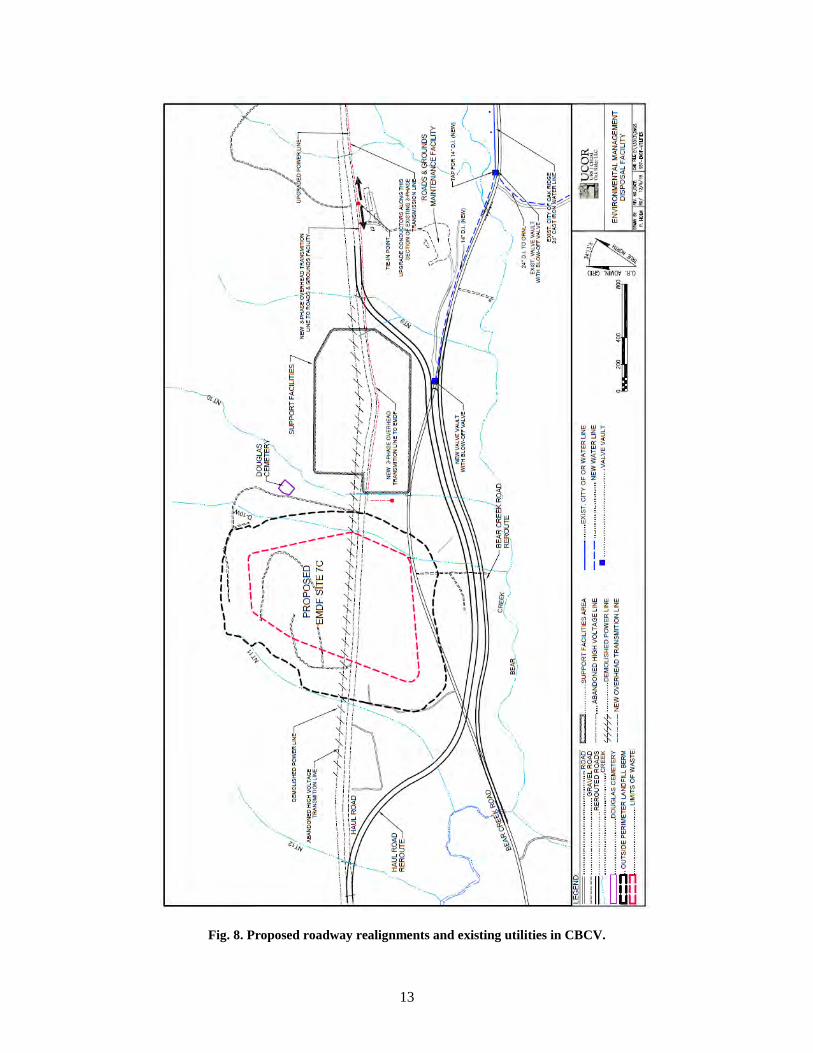
Use of the CBCV site for construction of EMDF requires relocation of a segment of the Haul Road, which presently bisects the proposed disposal cells, as well as a portion of Bear Creek Road to provide sufficient landfill capacity. These roads will be designed and rerouted as part of ESP activities.
Both roads will be rerouted to the southern portion of the site where the Maynardville Limestone is present along Bear Creek. The Haul Road will be rerouted between NT-9 and NT-12, a distance of approximately 5000 ft, while Bear Creek Road will be rerouted between NT-9 and its crossing of Bear Creek near NT-11, a distance of approximately 3880 ft. The conceptual realignment for both Bear Creek Road and the Haul Road are shown in Fig. 8. However, the final design and realignment are being developed and may change.
UCOR, an AECOM-led partnership with Jacobs, considered the following constraints:
• Provide the largest practical footprint for construction of the disposal cells while avoiding road construction to the greatest extent possible in the 500-year floodplain of Bear Creek.
• Avoid modifications to Bear Creek Road at the creek crossing west of the landfill site boundary where three 54-in. reinforced concrete pipe drain tiles extend under the roadway. Also avoid modifications to Bear Creek Road at the entrance to the Roads and Grounds Maintenance Facility to the east of the site boundary. Tie-ins between the existing road and the rerouted segment will fit between these two points.
• Establish roadway curves to be as large as possible, with a minimum curve radius, to allow safe traffic at the posted speed limit and proper sight distance.
• Maintain a 50-ft buffer between the edge of Bear Creek Road and the edge of the Haul Road.

12
Fig. 7. EMDF conceptual site layout.
13
Fig. 8. Proposed roadway realignments and existing utilities in CBCV.
14
3.2 UTILITIES EXTENSIONS
Utilities will be extended to the CBCV site as part of ESP activities. These utilities include electrical power, water, and voice and data communications. Existing utilities locations are shown in Fig. 8. Utility requirements will vary throughout the multiple stages of site development, but must be planned such that capacity is available for all phases of site activities over the life cycle of the project
It is assumed that no utilities will be extended specifically to any of the borrow areas. As such, power for distant borrow areas will be provided by portable generator. Portable sanitary facilities will be used, and water will be hauled in for soil conditioning. Radios or cellular phones will be used for communications to these sites.
3.2.1 Electrical Power
Electrical power will be extended to the eastern boundary of the CBCV site via a new 13.8 kV transmission line located on the south side of Haul Road. This new section is anticipated to tie back into the existing power line located at the northeastern corner of the Roads and Grounds Maintenance Facility that is approximately 2400 ft from the eastern boundary of the proposed landfill. If the existing power system at the Roads and Grounds Facility cannot sustain the additional load of EMDF, the conductors between the Roads and Ground Facility and the Liquid Storage Facility, 1500 ft east, will have to be upgraded. There is a lesser chance the conductors may have to be upgraded all the way to Y-12 if the demand exceeds the capacity of that segment of the power line.
Electrical power services must be sufficient enough to handle the power loads for all phases of EMDF development, including load demands for the landfill wastewater treatment facility, office complexes, climate controlled storage units (conex type), site exterior lighting, pumping systems, instrumentation and controls, heat tracing, and ground fault circuit interrupter receptacles for cord-connected tools or equipment. The onsite power distribution system will use transformers to step down the power from 13.8 kV and distribute the power on poles and in duct banks throughout EMDF.
Demolition of the existing 161 kV power transmission line will involve removing the wooden pole structures and hardware, conductors, guys, and ground rods that are within the developed footprint of EMDF. Details are being developed in the design that will identify the section to be demolished and address stabilization of the remaining portion of the line.
3.2.2 Water
Water is anticipated to be extended to the eastern boundary of the CBCV site via a new 14-in. ductile iron water line located on the north side of Bear Creek Road. The pipe size is an estimate at this time and will be refined based on hydraulic analysis performed during design preparation. It is anticipated that this new section will tie back into the City of Oak Ridge’s existing 24-in. main located southeast of the Roads and Grounds Maintenance Facility, approximately 2200 ft from the eastern boundary of the site.
Water services must be sufficient enough to handle the water demands for all phases of EMDF development, including site fire protection, building sprinkler systems, potable water for site personnel and the landfill wastewater treatment facility, and construction/dust control water for tanker trucks.
3.2.3 Voice and Data Communications
Voice and data cables are anticipated to be extended to the eastern boundary of the CBCV site via new 100 pair copper cable and a fiber optic cable. These new cables will be attached to the same electrical power

15
poles as used for power transmission. The voice and data communications cables will tie back into existing cables located adjacent to EMWMF, approximately 10,000 ft east of the CBCV site.
The EMDF site will require voice and data communications capabilities for telephones, computers, printers/plotters, reproduction equipment, Radio Frequency Identification towers, and badge readers at Limited Area entry portals.
3.3 BORROW AREA DEVELOPMENT
ESP actions at the borrow areas will include performing borrow area characterization to verify suitable materials and volumes are available at the preferred borrow areas; clearing and grubbing the selected areas for initial development; and designing, clearing, and constructing access roads and storm water management measures to allow for subsequent operation of the borrow areas.
3.3.1 Borrow Area Characterization
Geotechnical characterization will be conducted to collect data for use in evaluating soil borrow material quality, available quantities of soil borrow material, and stability of borrow excavation slopes to support the design of the borrow areas. Most of the sampling will be conducted to evaluate soil properties. However, in the case of soil at the UPF Spoils Area, sampling also will be conducted to assess the contaminant characteristics of material stored in the area prior to using UPF soil as a stockpile for waste management purposes.
A Field Sampling Plan (FSP) will be written to address all three borrow areas and will contain the detailed approach for each borrow area. Field activities assume temporary soil borings and test pits will be used to collect geotechnical soil samples. No piezometers will be installed. Laboratory testing will be conducted to determine how materials from each borrow area may be used for EMDF construction and operations. Temporary access roads and testing areas will be cleared.
Results of the borrow area characterization will be presented in a technical memorandum (TM).
3.3.2 Borrow Area Design and Construction
Preparation of the borrow areas will involve implementing erosion and sediment controls, clearing and/or harvesting trees, and constructing access roads for future borrow area operations. It is assumed that no ESP design or construction activities, such as construction of access roads, are required at the UPF Spoils Area as access is already well developed and sediment controls are the same as those that will be used during landfill construction. Borrow area designs will include drawings, specifications, and supporting calculations for development of the Site 7b and Central Borrow Areas. Borrow area phasing plans will be developed to support three phases of construction for EMDF as well as construction of the EMWMF final cap. As part of that phasing, timing for use of the UPF Spoils Area and soil generated onsite during grading efforts also must be considered. The design package will include detailed design development for the initial quantity of soil to be removed as well as planning (i.e., conceptual design) for future development to support three phases of borrow area development in addition to the ESP construction. Aspects of the design will include the following:
• Storm water controls, including sedimentation basins and other erosion controls
• Site access road as well as parking, laydown, and office areas
• Stockpile locations for each soil type and spoils

16
• Screen and pug mill layout
• Restoration during dormant periods and for areas/sections that are played out
Erosion and sediment control measures are anticipated to include approximately 3000 linear ft of silt fencing around disturbed areas at each site. Sedimentation basins will be constructed at the Site 7b and Central Borrow Areas only. Two sedimentation basins may be constructed at each site, each approximately 40 ft × 100 ft in size, requiring roughly 1200 cy of earthwork for construction of each basin. Final sizing of sediment basins will be in accordance with the latest edition of the Tennessee Erosion and Sediment Control Handbook (TDEC 2012). Basins will have an outlet control structure and a riprap-lined spillway. Onsite drainage controls will be used to direct runoff to the sediment basins and control discharge from the sediment basins. It is currently assumed that 3000 linear ft of drainage ditch approximately 3 ft deep will be constructed at each site, with half the length of each ditch being lined with riprap to control ditch erosion.
Harvesting trees deemed to be of commercial value, clearing and grubbing the remaining trees and brush in the area where borrow activities will start, and chipping the clearing and grubbing debris also will be included in borrow area preparation. Wood chips will be placed in windrows surrounding the site or will be used as ground cover for erosion control. The area then will be seeded and mulched for temporary erosion control. The UPF Spoils Area is cleared and will require no further clearing. The other two sites will require clearing of less than 15 acres total.
Access roads, approximately 25 ft wide with 12 in. of gravel and geotextile underlayment, will be constructed to allow temporary harvesting of trees and provide permanent borrow haul roads from the perimeter of the borrow area to the nearest roadway. While no access road is needed at the UPF Spoils Area, approximately 1500 linear ft of road is anticipated to be required at Site 7b, and 1800 linear ft of road is likely to be needed at the Central Borrow Area. Parking areas 2400 sf in size with 6 in. of gravel and geotextile underlayment also may be constructed to allow for operations personnel and visitors, but no parking areas are needed at the UPF Spoils Area.
Following ESP construction, the borrow areas will be seeded for stabilization of the disturbed areas.

17
4. DESIGN CRITERIA AND CODES
A design criteria document is being prepared to identify applicable codes and standards for ESP design. This document provides a summary of those criteria only and is not meant to be exhaustive or serve as a reference for those criteria. These criteria are listed in the following sections.
4.1 DOE ORDERS, GUIDANCE, AND POLICIES
The DOE Orders, guidance, and policies that are applicable during ESP activities are listed in Table 1. Implementation will occur through compliance with all UCOR policies and procedures for all UCOR subcontractors and memorandum of agreement or statement of work (SOW) language, as appropriate, for all DOE-direct contractors.
Table 1. DOE Orders, guidance, and policies applicable during ESP
Document number Document title
151.1D Comprehensive Emergency Management System
413.3B Program and Project Management for the Acquisition of Capital Assets
414.1C Quality Assurance
420.1C Change 2 Facility Safety
450.1A Sustainable Environmental Stewardship
450.4-1C and 450.4-4A Integrated Safety Management System Guide
DOE-STD-1020-2012 Natural Phenomena Hazards Analysis and Design Criteria for DOE Facilities
DOE-STD-1066-2016 Fire Protection Design
DOE-STD-1189 Integration of Safety into the Design Process DOE = U.S. Department of Energy ESP = Early Site Preparation
4.2 NATIONAL CONSENSUS STANDARDS AND CODES
The following standards and codes will be implemented during ESP design:
• American Society of Mechanical Engineers (ASME)
— ASME B1.20.1 Straight Pipe Threads for Mechanical Joints
— ASME B31.9 Building Services Piping
— ASME Boiler and Pressure Vessel Code, Section V and IX Nondestructive Examination
— ASME Y14.38 Abbreviations and Acronyms
• American Society for Nondestructive Testing (ASNT)
— ASNT-TC-1A-92 Personnel Qualification and Certification in Nondestructive Testing

18
• American Welding Society (AWS)
— AWS D1.1 Structural Welding Code
• American Water Works Association (AWWA)
— AWWA C509 Resilient-Seated Gate Valves
— AWWA C515 Reduced-Wall, Resilient-Seated Gate Valves for Water Supply Service.
— AWWA C605 Underground Installation of Polyvinyl Chloride (PVC) Pressure Pipe Fittings for Water
— AWWA C900 PVC Pressure Pipe & Fabricated Fittings, 4 in. Through 60 in.
— AWWA C906 Polyethylene Pressure Pipe & Fittings, 4 in. Through 66 in. for Waterworks
• National Fire Protection Association (NFPA)
— NFPA 1 Fire Code (2018)
— NFPA 10 Standard for Portable Fire Extinguishers (2018)
— NFPA 24 Standard for the Installation of Private Fire Service Mains and Their Appurtenances
— NFPA 70 National Electrical Code (2017)
— NFPA 70E Standard for Electrical Safety in the Workplace (2018)
— NFPA 101 Life Safety Code (2018)
— NFPA 780 Standard for the Installation of Lightning Protection Systems (2017)
• Federal and State Regulations
— 29 Code of Federal Regulations (CFR) 1910 Occupational Safety and Health Standards
— 29 CFR 1926 Safety and Health Regulations for Construction
— 40 CFR 1500-1508 National Environmental Policy Act
— Tennessee Department of Transportation Standard Specifications for Road and Bridge Construction
— TDEC Tennessee General National Pollutant Discharge Elimination System Permit for Discharges of Storm water associated with Construction Activities
— 23 CFR 655 Manual of Uniform Traffic Control Devices
• American Society of Civil Engineers (ASCE)
— Minimum Design Loads for Buildings and Other Structures, ASCE 7-10
• International Code Council
— 2012 International Building Code
• Institute of Electrical and Electronics Engineers (IEEE)
— IEEE C2 National Electrical Safety Code American National Standard C2, 2017 edition
— IEEE C135.1-1999 IEEE Standard for Zinc-Coated Steel Bolts and Nuts for Overhead Line Construction
— IEEE C135.3-2001 IEEE Standard for Zinc-Coated Ferrous Lag Screws for Overhead Line Construction

19
— IEEE C135.90-2014 IEEE Standard for Pole Line Hardware for Overhead Line Construction
— IEEE 142-2007 IEEE Recommended Practice for Grounding of Industrial and Commercial Power Systems
— IEEE 242-2001 IEEE Recommended Practice for Protection and Coordination of Industrial and Commercial Power Systems
— IEEE 835-1994 (R2012) IEEE Standard Power Cable Ampacity Tables
— IEEE 1410-2010 IEEE Guide for Improving the Lightning Performance of Electric Power Overhead Distribution Lines
— IEEE 1584-2002 IEEE Guide for Performing Arc-Flash Hazard Calculations
• Underwriters Laboratories (UL)
— UL 467-2013 Standard for Safety Grounding and Bonding Equipment
• United States Department of Agriculture
— Rural Utilities Service Bulletins listed in ES-1.1-2, Y-12 Engineering Standard for Medium Voltage Overhead Distribution.

20
This page intentionally left blank.

21
5. ARARS CROSSWALK
Table 2 provides a crosswalk of ARARs that must be met during ESP activities concerning the road reroutes, utilities extensions, and borrow area development. These ARARs identify federal and state chemical-, location-, and action-specific environmental and public health standards that must be met during construction. Occupational safety and worker radiation protection requirements are not covered under these ARARs.
Chemical-specific ARARs provide health- or risk-based concentration limits or discharge limits in various environmental media (i.e., surface water, groundwater, soil, and air) for specific hazardous substances, pollutants, and contaminants. However, there are no chemical-specific ARARs applicable during ESP activities. Location-specific ARARs ensure protection of sensitive resources that occur as a result of the location of the action. Action-specific ARARs are triggered by implementing the response action and primarily address the protection of surface water during ESP construction activities. Specific requirements under each ARAR are listed in Appendix A.

22
Table 2. Summary of ARARs for EMDF ESP
Location resource Prerequisite Citation Document where addressed Location-Specific: Wetlands Presence of wetlands as defined in 10 CFR 1022.4
DOE actions that involve potential impacts to, or take place within, wetlands—applicable
10 CFR 1022.3(a)(7) and (8) 10 CFR 1022.3(b) 10 CFR 1022.3(c) 10 CFR 1022.3(d) 10 CFR 1022.13(a)(3) 10 CFR 1022.14(a)
ESP Design
Presence of jurisdictional wetlands as defined in 40 CFR 230.3, 33 CFR 328.3(a), and 33 CFR 328.4
Actions that involve discharge of dredged or fill material into waters of United States, including jurisdictional wetlands—applicable
40 CFR 230.10(a), (b), (c), and (d) 40 CFR 230, Subpart H
SWPPP
Mitigation of state wetlands as defined under TDEC 0400-40-07-.03
Activity that would cause loss of wetlands as defined in TDEC 0400-40-07-.03—applicable
TDEC 0400-40-07-.04(7)(b) ESP Design
Location-Specific: Floodplains Presence of floodplain as defined in 10 CFR 1022.4
DOE actions that involve potential impacts to, or take place within, floodplains—applicable
10 CFR 1022.3(a)(1) through (6) 10 CFR 1022.3(b) and (d) 10 CFR 1022.3(c) 10 CFR 1022.13(a)(3) 10 CFR 1022.14(a)
Road Reroute Drawings
Location-Specific: Aquatic Resources Within an area potentially impacting “waters of the State” as defined in TCA 69-3-103(42)
Action potentially altering the properties of any “waters of the State”—applicable
TCA 69-3-108(l) TDEC 0400-40-07-.01
SWPPP
Location encompassing aquatic ecosystem as defined in 40 CFR 230.3(c)
Action that involves the discharge of dredged or fill material into “waters of the U.S.”, including jurisdictional wetlands—applicable
40 CFR 230.10(a), (b), (c), and (d) 40 CFR 230, Subpart H
SWPPP

23
Table 2. Summary of ARARs for EMDF ESP (cont.)
Location resource Prerequisite Citation Document where addressed Mitigation of state waters other than wetlands
Activity that would result in an appreciable permanent loss of resource value of a state water —applicable
TDEC 0400-40-07-.04(7)(a) SWPPP
Within area impacting stream or any other body of water -and- presence of wildlife resources (e.g., fish)
Action that impounds, modifies, diverts, or controls waters, including navigation and drainage activities—relevant and appropriate
Fish and Wildlife Coordination Act (16 USC 662(a))
Additional characterization will be performed for the borrow area development. If necessary, a mitigation approach will be discussed in future documents.
Location-Specific: Cultural Resources Presence of human remains, funerary objects, sacred objects, or objects of cultural patrimony
Excavation activities that inadvertently discover such resources on federal lands or under federal control—applicable
43 CFR 10.4(d)(ii) UCOR Stop Work Procedure (UCOR PROC-EH-2018)
Location-Specific: Threatened and Endangered Species Presence of Tennessee nongame species as defined in TCA 70-8-103 and listed in TWRA Proclamations 00-14 and 00-15
Action impacting Tennessee nongame species, including wildlife species which are “in need of management” (as listed in TWRA Proclamations 00-14 and 00-15 as amended by 00-21) —applicable
TCA 70-8-104(b) and (c) TCA 70-8-106(e)
Additional characterization will be performed for the borrow area development. If necessary, a mitigation approach will be discussed in future documents.
Presence of federally endangered or threatened species, as designated in 50 CFR 17.11 and 17.12 or critical habitat of such species
Action that is likely to jeopardize fish, wildlife, or plant species or destroy or adversely modify critical habitat—applicable
16 USC 1531 et seq., Sect. 7(a)(2) Additional characterization will be performed for the borrow area development. If necessary, a mitigation approach will be discussed in future documents.
Presence of Tennessee-listed endangered or rare plant species as listed in TDEC 0400-06-02-.04
Action impacting rare plant species including, but not limited to, federally listed endangered species—relevant and appropriate
TCA 70-8-309(a) 16 USC 1531 et seq. TDEC 0400-06-02-.04
Additional characterization will be performed for the borrow area development. If necessary, a mitigation approach will be discussed in future documents.

24
Table 2. Summary of ARARs for EMDF ESP (cont.)
Action Prerequisite Citation Document where addressed Action-Specific: Construction Activities causing fugitive dust emissions
Use, construction, alteration, repair, or demolition of a building, or appurtenances or a road or the handling, transport or storage of material—applicable
TDEC 1200-3-8-.01(1) TDEC 1200-3-8-.01(1)(a) TDEC 1200-3-8-.01(1)(b) TDEC 1200-3-8-.01(2)
Subcontractor SOW
Activities causing storm water runoff Existing and new storm water discharges associated with industrial activity—applicable
TCA 69-3-108(e) through (j) TCA 69-3-108(l) TDEC 0400-40-10-.03(2)(a)
SWPPP
Activities causing storm water runoff (e.g., clearing, grading, excavation)
Storm water discharges associated with construction activities that disturb ≥ 1 acre total—relevant and appropriate
TCA 69-3-108(l) SWPPP
Action-Specific: Secondary Waste and WAC Attainment Characterization of solid waste (e.g., construction debris, soil)
Generation of solid waste as defined in TDEC 0400-12-01-.02(1)(b), and which is not excluded under TDEC 0400-12-01-.02(1)(d)(1)—applicable
TDEC 0400-12-01-.03(1)(b)(1) TDEC 0400-12-01-.03(1)(b)(2) TDEC 0400-12-01-.03(1)(b)(3)
SPP, Sect. 6
Management of hazardous waste on site
Generation of RCRA hazardous waste for storage, treatment, or disposal onsite—applicable if secondary wastes are determined to be hazardous
TDEC 0400-12-01-.03(1)(a)(3) SPP, Sect. 6
ARAR = applicable or relevant and appropriate requirement CFR = Code of Federal Regulations DOE = U.S. Department of Energy EMDF = Environmental Management Disposal Facility ESP = Early Site Preparation RCRA = Resource Conservation and Recovery Act of 1976 SOW = statement of work
SPP = Site Preparation Plan SWPPP = Storm Water Pollution Prevention Plan TCA = Tennessee Code Annotated TDEC = Tennessee Department of Environment and Conservation TWRA = Tennessee Wildlife Resources Agency USC = United States Code WAC = waste acceptance criteria

25
6. WASTE MANAGEMENT
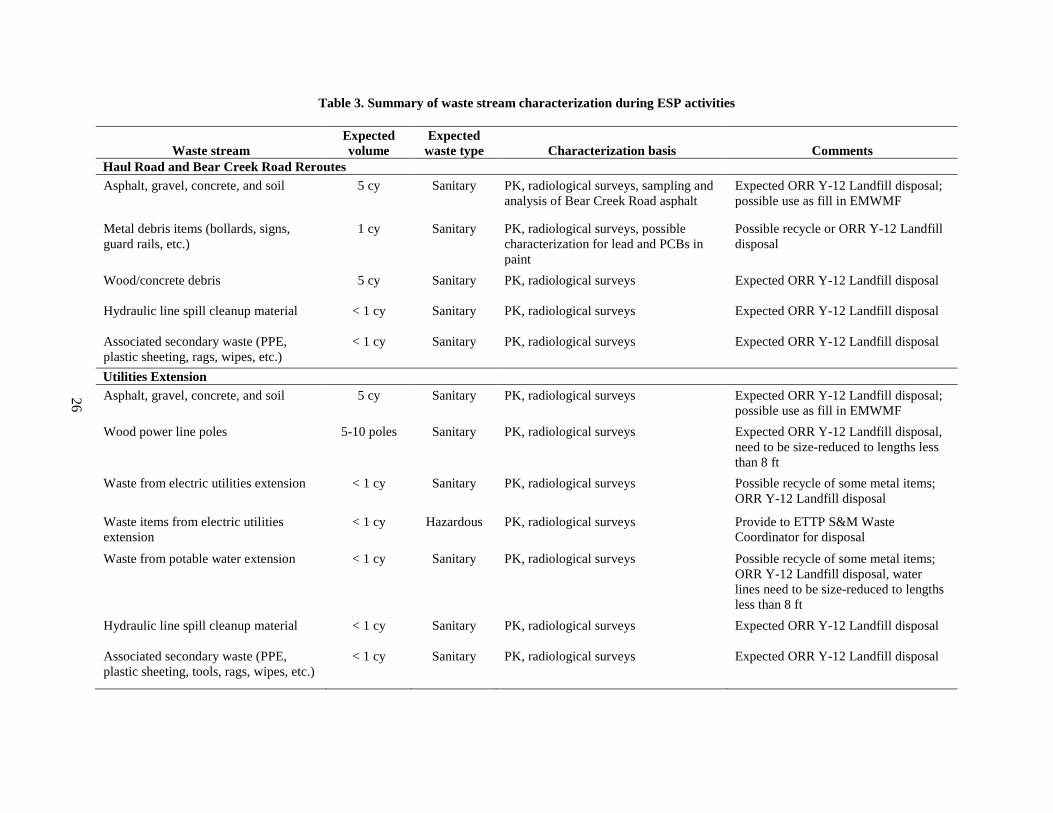
This section identifies the waste streams that are expected to be generated during the three planned phases of ESP activities. A summary of waste characterization during ESP activities is provided in Table 3, which describes, quantifies, and defines waste streams and identifies the expected disposal outlet(s). The waste streams identified and described in this section are in Waste Information Form WIF0477.
Wastes generated by the three planned phases of ESP are not expected to be radioactively contaminated. Characterization of the proposed Sites 7b and 7c in CBCV was summarized in the Remedial Investigation/Feasibility Study for Comprehensive Environmental Response, Compensation, and Liability Act Oak Ridge Reservation Waste Disposal Oak Ridge, Tennessee (DOE 2017a) (RI/FS). This document presents no evidence of radioactive contamination at the sites. Additionally, the Composite Analysis for the Environmental Management Waste Management Facility and the Environmental Management Disposal Facility, Oak Ridge, Tennessee (UCOR 2018) did not identify any radiologically contaminated sites in BCV southwest of the Bear Creek Burial Grounds at approximately Bear Creek kilometer (BCK) 9.2. Site 7c, the East Knoll, and the previous borrow areas on Chestnut Ridge are all southwest of BCK 9.2. A custodial justification covering repairs to the Haul Road (UCOR Form 2118) was prepared in July 2018. This custodial justification documented that the Haul Road was not radiologically contaminated. Consequently, gravel, soil, and vegetation generated during the repairs would be eligible for disposal in the ORR Y-12 Landfill Spoils Pile.
Similarly, environmental media at the sites (Site 7c, East Knoll, previous borrow areas, and current and future locations of Haul Road and Bear Creek Road) that will be generated during the three phases of ESP are not hazardous as defined by RCRA. No sources of listed waste were identified at CBCV Site 7c or 7b in the RI/FS. The 2017 Remedial Effectiveness Report for the U.S. Department of Energy Oak Ridge Reservation, Oak Ridge, Tennessee (DOE 2017b) also does not document any environmental media in BCV as listed and documents that no toxicity characteristic contaminants listed in 40 CFR 261.24, Table 1, are included in the routine groundwater and surface water monitoring in BCV.
Vegetation removed during ESP activities is not expected to be waste. Marketable timber will be harvested, segregated, and removed. The remaining vegetation will be left at the respective site and used for mulch and/or erosion control (some of which may be chipped). Secondary waste generated during the primary waste-generating activities is expected to be disposed with the primary waste streams.
6.1 ROAD REROUTES
It is assumed that unused materials from the construction of the rerouted sections of Bear Creek Road and the Haul Road will be removed from the site by the contractor performing the work and will not be a waste stream managed during this activity. Expected waste streams from the road reroutes include the following:
• Asphalt, gravel, and soil from road demolition
• Metal debris items (such as bollards, guard rails, road signs, etc.)
• Wood/concrete debris from limited activities, such as forming and placing concrete for headwalls or splash pads at new culvert installations
• Hydraulic line spill cleanup material (during construction activities)
• Associated secondary waste (personal protective equipment [PPE], plastic sheeting, rags, wipes, etc.)
26
Table 3. Summary of waste stream characterization during ESP activities
Waste stream Expected volume
Expected waste type Characterization basis Comments
Haul Road and Bear Creek Road Reroutes Asphalt, gravel, concrete, and soil 5 cy Sanitary PK, radiological surveys, sampling and
analysis of Bear Creek Road asphalt Expected ORR Y-12 Landfill disposal; possible use as fill in EMWMF
Metal debris items (bollards, signs, guard rails, etc.)
1 cy Sanitary PK, radiological surveys, possible characterization for lead and PCBs in paint
Possible recycle or ORR Y-12 Landfill disposal
Wood/concrete debris 5 cy Sanitary PK, radiological surveys Expected ORR Y-12 Landfill disposal
Hydraulic line spill cleanup material < 1 cy Sanitary PK, radiological surveys Expected ORR Y-12 Landfill disposal
Associated secondary waste (PPE, plastic sheeting, rags, wipes, etc.)
< 1 cy Sanitary PK, radiological surveys Expected ORR Y-12 Landfill disposal
Utilities Extension Asphalt, gravel, concrete, and soil 5 cy Sanitary PK, radiological surveys Expected ORR Y-12 Landfill disposal;
possible use as fill in EMWMF Wood power line poles 5-10 poles Sanitary PK, radiological surveys Expected ORR Y-12 Landfill disposal,
need to be size-reduced to lengths less than 8 ft
Waste from electric utilities extension < 1 cy Sanitary PK, radiological surveys Possible recycle of some metal items; ORR Y-12 Landfill disposal
Waste items from electric utilities extension
< 1 cy Hazardous PK, radiological surveys Provide to ETTP S&M Waste Coordinator for disposal
Waste from potable water extension < 1 cy Sanitary PK, radiological surveys Possible recycle of some metal items; ORR Y-12 Landfill disposal, water lines need to be size-reduced to lengths less than 8 ft
Hydraulic line spill cleanup material < 1 cy Sanitary PK, radiological surveys Expected ORR Y-12 Landfill disposal
Associated secondary waste (PPE, plastic sheeting, tools, rags, wipes, etc.)
< 1 cy Sanitary PK, radiological surveys Expected ORR Y-12 Landfill disposal

27
Table 3. Summary of waste stream characterization during ESP activities (cont.)
Waste stream Expected volume
Expected waste type Characterization basis Comments
Borrow Area Development Hydraulic line spill cleanup material and associated secondary waste
< 1 cy Sanitary PK, radiological surveys Expected ORR Y-12 Landfill disposal
EMWMF = Environmental Management Waste Management Facility ESP = Early Site Preparation ETTP = East Tennessee Technology Park ORR = Oak Ridge Reservation PCB = polychlorinated biphenyl
PK = process knowledge PPE = personal protective equipment S&M = Surveillance and Maintenance Y-12 = Y-12 National Security Complex

28
The expected waste streams for this activity are detailed in Table 3, including the expected volume, waste type(s), characterization basis, expected disposal outlet(s), and other relevant waste management information. All of the waste from this activity is expected to be eligible for disposal in the ORR Y-12 Landfills. Asphalt, gravel, and soil generated during road demolition may be considered as fill in EMWMF. Grab samples of the asphalt from Bear Creek Road will be collected and analyzed for gross alpha/beta, strontium-90, and total uranium (in picocuries per gram) to confirm the eligibility of the asphalt for ORR Y-12 Landfill disposal. There is a possibility that some or all of the metal debris items can be recycled. However, painted items may need to be characterized to determine if the paint contains lead or polychlorinated biphenyls.
6.2 UTILITIES EXTENSIONS
During the utilities extensions, it is assumed that unused materials from utility upgrades will be removed from the site by the contractor performing the work and will not be a waste stream managed during this activity. However, materials from existing utilities that are removed will be considered waste and will be appropriately managed. Expected waste streams include the following:
• Asphalt, gravel, concrete, and/or soil from the burial of utilities and removal of utility poles
• Components from existing utilities removed during this activity (wooden utility poles, insulators, conduit, electrical wire, piping, etc.)
• Hydraulic line spill cleanup material (during utility excavation/installation)
• Associated secondary waste (PPE, plastic sheeting, tools, rags, wipes, etc.)
All of the waste from this activity is expected to be eligible for disposal in the ORR Y-12 Landfills. Asphalt, gravel, and soil from implementing this work may be considered as fill in EMWMF. It is possible that some electrical equipment could be determined to be a hazardous waste as defined by RCRA. That waste (if any) will be managed consistently with other UCOR hazardous waste. The expected waste streams for this activity are listed in Table 3, including the expected volume, waste type(s), characterization basis, expected disposal outlet(s), and other relevant waste management information.
6.3 BORROW AREA DEVELOPMENT
During the borrow area development, it is assumed that unused materials from access road construction will be removed from the site by the contractor performing the work and will not be a waste stream managed during this activity. Soil generated during test pit installation will be replaced in the pit. Cuttings generated during boring activities will be placed back in the hole, to the extent possible, or spread around the area. Laboratory sample wastes will be handled by the laboratory. The use of hydraulic equipment assumes the possibility that hydraulic line cleanup material and associated secondary waste could be generated. This waste (if any) is expected to be eligible for disposal in the ORR Y-12 Landfills.
The expected waste streams for this activity are listed in Table 3, including the expected volume, waste type(s), characterization basis, expected disposal outlet(s), and other relevant waste management information.

29
7. PROJECT ORGANIZATION AND SCHEDULE
7.1 PROJECT ORGANIZATION
The organizational structure for this project is presented in Fig. 9.
Fig. 9. EMDF project organization.
7.1.1 OREM
OREM is responsible for developing the project scope of work; ensuring the work scope is performed in a safe, compliant, and effective manner; and maintaining the project scope, schedule, and costs. OREM also is responsible for approving deliverables and providing funding/resources to the project.
The OREM Landfills Project Manager is responsible for maintaining the overall scope, schedule, and costs. The OREM Contracting Officer (CO) and CO Representative are responsible for managing compliance with contract requirements and determining if changes to contracts are necessary or required. OREM staff, including subject matter experts and facility representatives, are responsible for providing general oversight of the contractor’s safety and compliance performance.
OREM will procure contractors to implement the construction of the Haul Road reroute and utilities extensions.

30
7.1.2 Regulators
TDEC and EPA have review/approval authority over characterization, design, and construction activities, including reviewing the SPP under FFA protocols.
7.1.3 UCOR
UCOR will provide additional project management and support oversight for the project, which includes coordination of overall planning, scheduling, directing, controlling, and reporting for the execution of the work. UCOR, through its corporate reachback, will prepare the design documents for the road reroute, utilities extensions, and borrow area preparations.
UCOR will plan and oversee borrow area characterization, including preparation of the FSP and characterization TM and installation of temporary characterization roads. UCOR subcontractors will conduct the field boring and test pit installations and laboratory testing.
UCOR will procure subcontractors to provide surveying services and implement construction of the borrow area preparation.
UCOR will support DOE procurement of the prime construction contractor(s) to reroute the roads and extend the utilities by preparing draft SOWs, technically reviewing proposals, answering questions, supplying design and site information, and supporting pre-bid meetings, tours, and site access.
UCOR will provide construction oversight for OREM during the road reroutes and utilities extensions. Oversight will include reviewing submittals, assisting with site access, providing field oversight, conducting construction completion walkdowns, and supporting construction closeout.
UCOR will provide Title III engineering services to OREM on the road reroute, utilities extensions, and borrow area development through the Engineer of Record (i.e., the designer). Title III services include maintaining records of design changes or requests for information, reviewing contractor and/or subcontractor submittals for conformance to design requirements, and preparing as-built documentation through the Engineer of Record. As such, the Engineer of Record will prepare and issue a final set of construction as-built drawings and specifications, incorporating any design changes.
7.2 PROJECT SCHEDULE
Key schedule assumptions include the following:
• Project start date was August 1, 2018, and project finish date is summer 2020.
• Field characterization at the borrow areas is assumed to start in spring 2019 and last several months.
• Design of the road reroute, utilities extensions, and borrow area preparations is anticipated to be completed early fiscal year 2019.
• Construction is assumed to begin in winter 2020 and be complete in summer 2020.

31
8. REFERENCES
CH2M 2017. Borrow Area Study, EMDF-TMEM-001 CH2M, Knoxville, TN.
Daniel 1989. Final Report– Permeability of Compacted Soils from the East and West Borrow Areas, Y-12 Plant, Oak Ridge, Tennessee, D. E. Daniel, prepared for Martin Marietta Energy Systems, Inc.
DOE 1992. Federal Facility Agreement for the Oak Ridge Reservation, DOE/OR-1014, U.S. Environmental Protection Agency Region 4, Atlanta, GA; U.S. Department of Energy, Oak Ridge, TN; and Tennessee Department of Environment and Conservation, Nashville, TN.
DOE 2017a. Remedial Investigation/Feasibility Study for the Comprehensive Environmental Response, Compensation, and Liability Act Oak Ridge Reservation Waste Disposal, Oak Ridge, Tennessee, DOE/OR/01-2535&D5, U.S. Department of Energy, Office of Environmental Management, Oak Ridge, TN.
DOE 2017b. 2017 Remedial Effectiveness Report for the U.S. Department of Energy Oak Ridge Reservation, Oak Ridge, Tennessee, DOE/OR/01-2731&D2, U.S. Department of Energy, Office of Environmental Management, Oak Ridge, TN.
UCOR 2018. Composite Analysis for the Environmental Management Waste Management Facility and the Environmental Management Disposal Facility, Oak Ridge, Tennessee, UCOR-5095, latest revision, UCOR, an AECOM-led partnership with Jacobs, Oak Ridge, TN.
TDEC 2012. Tennessee Erosion and Sediment Control Handbook, latest edition, Tennessee Department of Environment and Conservation, Nashville, TN.

32
This page intentionally left blank.

APPENDIX A. APPLICABLE OR RELEVANT AND APPROPRIATE REQUIREMENTS
CROSSWALK TABLES

This page intentionally left blank.

A-3
Table A.1. Location-specific ARARs for EMDF ESP
Location resource Requirements Prerequisite Citation Document where
addressed Wetlands Presence of wetlands as defined in 10 CFR 1022.4
• Incorporate wetland protection considerations into its planning, regulatory, and decision-making processes, and, to the extent practicable, minimize the destruction, loss, or degradation of wetlands; and preserve and enhance the natural and beneficial values of wetlands.
DOE actions that involve potential impacts to, or take place within, wetlands—applicable
10 CFR 1022.3(a)(7) and (8)
ESP Design
• Undertake a careful evaluation of the potential effects of any proposed wetland action.
10 CFR 1022.3(b)
• Avoid, to the extent possible, the long- and short-term adverse impacts associated with the destruction of and occupancy and modification of wetlands. Avoid direct and indirect development in a wetland wherever there is a practicable alternative.
10 CFR 1022.3(c)
• Identify, evaluate, and, as appropriate, implement alternative actions that may avoid or mitigate adverse wetland impacts.
10 CFR 1022.3(d)
• Alternatives. Consider alternatives to the proposed action that avoid adverse impacts and incompatible development in a wetland area, including alternate sites, alternate actions, and no action. DOE shall evaluate measures that mitigate the adverse effects of actions in a wetland including, but not limited to, minimum grading requirements, runoff controls, design and construction constraints, and protection of ecologically sensitive areas.
10 CFR 1022.13(a)(3)
• If no practicable alternative to locating or conducting the action in the wetland is available, then before taking action design or modify the action in order to minimize potential harm to or within the wetland, consistent with the policies set forth in Executive Order 11990.
10 CFR 1022.14(a)

Table A.1. Location-specific ARARs for EMDF ESP (cont.)
A-4
Location resource Requirements Prerequisite Citation Document where
addressed Presence of jurisdictional wetlands as defined in 40 CFR 230.3, 33 CFR 328.3(a), and 33 CFR 328.4
The discharge of dredged or fill material into waters of the United States, including jurisdictional wetlands, is prohibited if there is a practical alternative that would have less adverse impact. No discharge shall be permitted that results in violation of state water quality standards, violates any toxic effluent standard, and/or jeopardizes an endangered species or its critical habitat. No discharge will be permitted that will cause significant degradation of waters of the United States. No discharge is permitted unless mitigation measures have been taken in accordance with 40 CFR 230, Subpart H.
Actions that involve discharge of dredged or fill material into waters of United States, including jurisdictional wetlands—applicable
40 CFR 230.10(a), (b), (c), and (d) 40 CFR 230, Subpart H
SWPPP
Mitigation of state wetlands as defined under TDEC 0400-40-07-.03
If an applicant proposes an activity that would result in appreciable permanent loss of resource value of wetlands, the applicant must provide mitigation, which results in no overall net loss of resource value. Compensatory measures must be at a ratio of 2:1 for restoration, 4:1 for creation and enhancement, and 10:1 for preservation, or at a best professional judgment ratio agreed to by the state. For any mitigation involving the enhancement or preservation of existing wetlands, to the extent practicable, the applicant shall complete the mitigation before any impact occurs to the existing state waters. For any mitigation involving restoration or creation of a wetland, to the extent practicable, the mitigation shall occur either before or simultaneously with impacts to the existing state waters. Mitigation actions for impacts to wetlands are prioritized as listed in TDEC 0400-40-07-.04 (7)(b)(1)(i) – (viii).
Activity that would cause loss of wetlands as defined in TDEC 0400-40-07-.03 —applicable
TDEC 0400-40-07-.04 (7)(b)
ESP Design
Floodplains Presence of floodplain as defined in 10 CFR 1022.4
• Incorporate floodplain management goals into planning, regulatory, and decision-making processes, and, to the extent practicable, reduce the risk of flood loss; minimize the impact of floods on human safety, health, and welfare; restore and preserve natural and beneficial values served by floodplains; require the construction of
DOE actions that involve potential impacts to, or take place within, floodplains—applicable
10 CFR 1022.3(a)(1) through (6)
Road Reroute Drawings

Table A.1. Location-specific ARARs for EMDF ESP (cont.)
A-5
Location resource Requirements Prerequisite Citation Document where
addressed Presence of floodplain as defined in 10 CFR 1022.4 (cont.)
DOE structures and facilities to be, at a minimum, in accordance with FEMA National Flood Insurance Program building standards; and promote public awareness of flood hazards by providing conspicuous delineations of past and probable flood heights on DOE property that is in an identified floodplain.
• Undertake a careful evaluation of the potential effects of any proposed floodplain action. Identify, evaluate, and, as appropriate, implement alternative actions that may avoid or mitigate adverse floodplain impacts.
10 CFR 1022.3(b) and (d)
• Avoid, to the extent possible, the long- and short-term adverse impacts associated with the occupancy and modification of floodplains. Avoid direct and indirect development in a floodplain wherever there is a practicable alternative.
10 CFR 1022.3(c)
• Consider alternatives to the proposed action that avoid adverse impacts and incompatible development in the floodplain, including alternate sites, alternate actions, and no action. DOE shall evaluate measures that mitigate the adverse effects of actions in a floodplain including, but not limited to, minimum grading requirements, runoff controls, design and construction constraints, and protection of ecologically-sensitive areas.
10 CFR 1022.13(a)(3)
• If no practicable alternative to locating or conducting the action in the floodplain is available, then before taking action design or modify the action in order to minimize potential harm to or within the floodplain, consistent with the policies set forth in Executive Order 11988.
10 CFR 1022.14(a)

Table A.1. Location-specific ARARs for EMDF ESP (cont.)
A-6
Location resource Requirements Prerequisite Citation Document where
addressed Aquatic Resources Within an area potentially impacting “waters of the State” as defined in TCA 69-3-103(42)
Must comply with the [substantive] requirements of the ARAP for erosion and sediment control to prevent pollution of waters of the state. Pollution control requirements are detailed in each particular General Permit.
Action potentially altering the properties of any "waters of the State"—applicable
TCA 69-3-108(l) TDEC 0400-40-07-.01
SWPPP
Location encompassing aquatic ecosystem as defined in 40 CFR 230.3(c)
The discharge of dredged or fill material into waters of the United States is prohibited if there is a practical alternative that would have less adverse impact. No discharge shall be permitted that results in violation of state water quality standards, violates any toxic effluent standard, and/or jeopardizes an endangered species or its critical habitat. No discharge will be permitted that will cause significant degradation of waters of the United States. No discharge of dredged or fill material shall be permitted unless appropriate and practicable steps in accordance with 40 CFR 230.70 et seq. are taken that will minimize potential adverse impacts of the discharge on the aquatic ecosystem.
Action that involves the discharge of dredged or fill material into “waters of the U.S.,” including jurisdictional wetlands—applicable
40 CFR 230.10(a), (b), (c), and (d) 40 CFR 230, Subpart H
SWPPP
Mitigation of state waters other than wetlands
Must provide mitigation that results in no overall net loss of resource values for any activity that would result in appreciable permanent loss of resource value of a state water. For any mitigation involving relocation or re-creation of a stream segment, to extent practicable must complete mitigation before any impact occurs to existing state waters. Mitigation measures include but are not limited to: restoration of degraded stream reaches and/or riparian zones; new (relocated) stream channels; removal of pollutants from and hydrologic buffering of storm water runoff; and other measures which have a reasonable likelihood of increasing the resource value of a state water. Mitigation measures or actions should be prioritized in the following order: restoration, enhancement, re-creation, and protection.
Activity that would result in an appreciable permanent loss of resource value of a state water —applicable
TDEC 0400-40-07-.04 (7)(a)
SWPPP
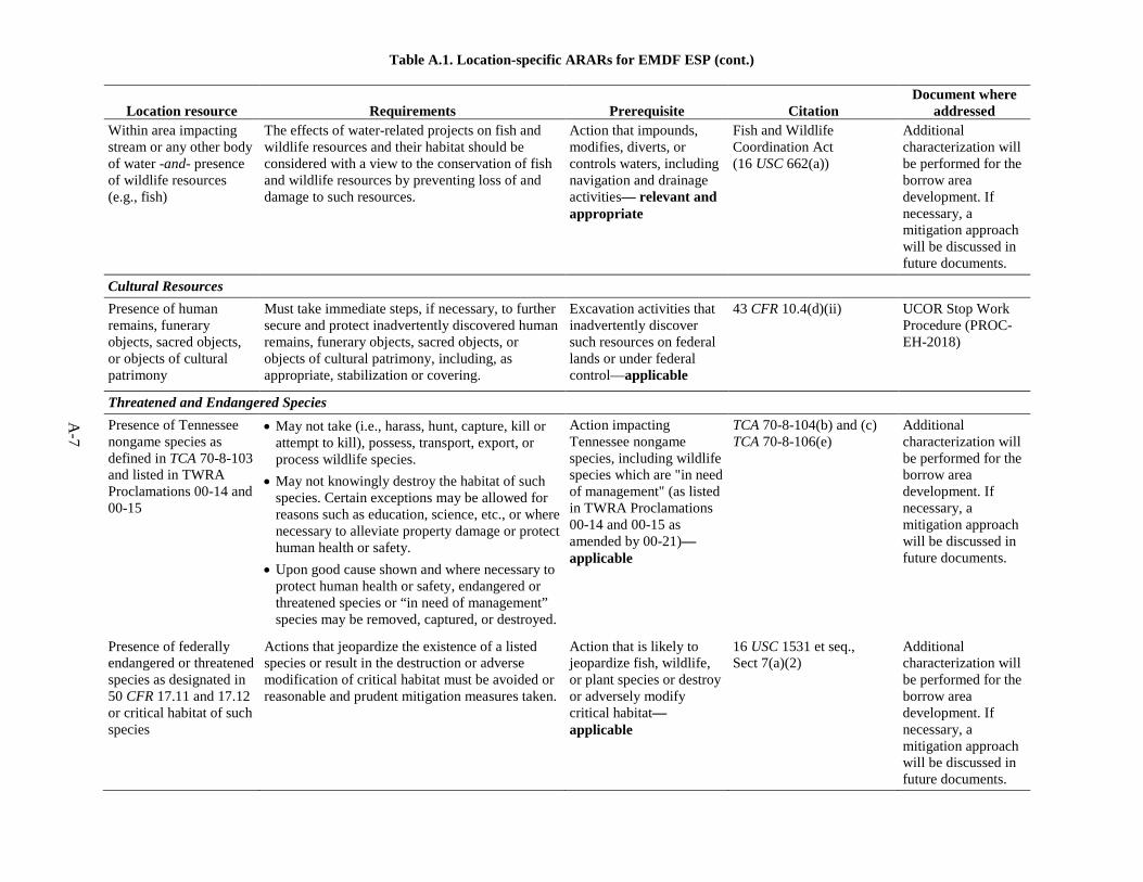
Table A.1. Location-specific ARARs for EMDF ESP (cont.)
A-7
Location resource Requirements Prerequisite Citation Document where
addressed Within area impacting stream or any other body of water -and- presence of wildlife resources (e.g., fish)
The effects of water-related projects on fish and wildlife resources and their habitat should be considered with a view to the conservation of fish and wildlife resources by preventing loss of and damage to such resources.
Action that impounds, modifies, diverts, or controls waters, including navigation and drainage activities— relevant and appropriate
Fish and Wildlife Coordination Act (16 USC 662(a))
Additional characterization will be performed for the borrow area development. If necessary, a mitigation approach will be discussed in future documents.
Cultural Resources Presence of human remains, funerary objects, sacred objects, or objects of cultural patrimony
Must take immediate steps, if necessary, to further secure and protect inadvertently discovered human remains, funerary objects, sacred objects, or objects of cultural patrimony, including, as appropriate, stabilization or covering.
Excavation activities that inadvertently discover such resources on federal lands or under federal control—applicable
43 CFR 10.4(d)(ii) UCOR Stop Work Procedure (PROC-EH-2018)
Threatened and Endangered Species Presence of Tennessee nongame species as defined in TCA 70-8-103 and listed in TWRA Proclamations 00-14 and 00-15
• May not take (i.e., harass, hunt, capture, kill or attempt to kill), possess, transport, export, or process wildlife species.
• May not knowingly destroy the habitat of such species. Certain exceptions may be allowed for reasons such as education, science, etc., or where necessary to alleviate property damage or protect human health or safety.
• Upon good cause shown and where necessary to protect human health or safety, endangered or threatened species or “in need of management” species may be removed, captured, or destroyed.
Action impacting Tennessee nongame species, including wildlife species which are "in need of management" (as listed in TWRA Proclamations 00-14 and 00-15 as amended by 00-21)—applicable
TCA 70-8-104(b) and (c) TCA 70-8-106(e)
Additional characterization will be performed for the borrow area development. If necessary, a mitigation approach will be discussed in future documents.
Presence of federally endangered or threatened species as designated in 50 CFR 17.11 and 17.12 or critical habitat of such species
Actions that jeopardize the existence of a listed species or result in the destruction or adverse modification of critical habitat must be avoided or reasonable and prudent mitigation measures taken.
Action that is likely to jeopardize fish, wildlife, or plant species or destroy or adversely modify critical habitat—applicable
16 USC 1531 et seq., Sect 7(a)(2)
Additional characterization will be performed for the borrow area development. If necessary, a mitigation approach will be discussed in future documents.

Table A.1. Location-specific ARARs for EMDF ESP (cont.)
A-8
Location resource Requirements Prerequisite Citation Document where
addressed Presence of Tennessee-listed endangered or rare plant species as listed in TDEC 0400-06-02-.04
May not knowingly uproot, dig, take, remove, damage or destroy, possess or otherwise disturb for any purposes any endangered species.
Action impacting rare plant species including, but not limited to, federally listed endangered species—relevant and appropriate
TCA 70-8-309(a) 16 USC 1531 et seq. TDEC 0400-06-02-.04
Additional characterization will be performed for the borrow area development. If necessary, a mitigation approach will be discussed in future documents.
ARAP = Aquatic Resource Alteration Permit ARAR = applicable or relevant and appropriate requirement CFR = Code of Federal Regulations DOE = U.S. Department of Energy EMDF = Environmental Management Disposal Facility ESP = Early Site Preparation
FEMA = Federal Emergency Management Agency SWPPP = Storm Water Pollution Prevention Plan TCA = Tennessee Code Annotated TDEC = Tennessee Department of Environment and Conservation TWRA = Tennessee Wildlife Resources Agency USC = United States Code

A-9
Table A.2. Action-specific ARARs for EMDF ESP
Action Requirements Prerequisite Citation Document where
addressed Construction Activities causing fugitive dust emissions
Shall take reasonable precautions to prevent particulate matter from becoming airborne. Reasonable precautions shall include, but are not limited to the following:
Use, construction, alteration, repair, or demolition of a building, or appurtenances or a road or the handling, transport or storage of material—applicable
TDEC 1200-3-8-.01 (1)
Subcontractor SOW
• Use, where possible, of water or chemicals for control of dust in demolition of existing buildings or structures, construction operations, grading of roads, or the clearing of land;
TDEC 1200-3-8-.01 (1)(a)
• Application of asphalt, oil, water, or suitable chemicals on dirt roads, materials stock piles, and other surfaces which can create airborne dusts;
TDEC 1200-3-8-.01 (1)(b)
• Shall not cause or allow fugitive dust to be emitted in such a manner to exceed 5 minute/hour or 20 minute/day beyond property boundary lines on which emission originates.
TDEC 1200-3-8-.01 (2)
Activities causing storm water runoff
Shall develop and implement storm water management controls to insure compliance with the terms and conditions of General Permit No. TNR050000 (“Storm Water Multi-Sector General Permit for Industrial Activities”) or any applicable site-specific permit.
Existing and new storm water discharges associated with industrial activity—applicable
TCA 69-3-108(e) through (j) TCA 69-3-108(l) TDEC 0400-40-10-.03(2)(a)
SWPPP
Activities causing storm water runoff (e.g., clearing, grading, excavation)
Implement good construction management techniques (including sediment and erosion, vegetative controls, and structural controls) in accordance with the substantive requirements of General Permit No. TNR10-0000 and
Storm water discharges associated with construction activities that disturb ≥ 1 acre total—relevant and appropriate
TCA 69-3-108(l) SWPPP

Table A.2. Action-specific ARARs for EMDF ESP (cont.)
A-10
Action Requirements Prerequisite Citation Document where
addressed Activities causing storm water runoff (e.g., clearing, grading, excavation) (cont.)
TNR05-0000, to ensure storm water discharge is properly managed.
Secondary Waste and WAC Attainment Characterization of solid waste (e.g., construction debris, soil)
Must determine if waste is hazardous waste or if waste is excluded under TDEC 0400-12-01-.02(1)(d); and
Generation of solid waste as defined in TDEC 0400-12-01-.02(1)(b), and which is not excluded under TDEC 0400-12-01-.02(1)(d)(1)—applicable
TDEC 0400-12-01-.03(1)(b)(1)
SPP, Sect. 6
Must determine if waste is listed under TDEC 0400-12-01-.02(4); or
TDEC 0400-12-01-.03(1)(b)(2)
Must characterize waste by using prescribed testing methods or applying generator knowledge based on information regarding material or processes used.
TDEC 0400-12-01-.03(1)(b)(3)
Management of hazardous waste on site
A generator who treats, stores, or disposes of hazardous waste on-site must comply with the applicable [substantive] standards and requirements set forth in TDEC 0400-12-01-.05, .06, .07, .09, and .10.
Generation of RCRA hazardous waste for storage, treatment, or disposal onsite—applicable if secondary wastes are determined to be hazardous
TDEC 0400-12-01-.03(1)(a)(3)
SPP, Sect. 6
ARAR = applicable or relevant and appropriate requirements EMDF = Environmental Management Disposal Facility ESP = Early Site Preparation RCRA = Resource Conservation and Recovery Act of 1976 SOW = statement of work
SWPPP = Storm Water Pollution Prevention Plan TCA = Tennessee Code Annotated TDEC = Tennessee Department of Environment and Conservation WAC = waste acceptance criteria

DOE/OR/01-2805&D1
RECORD COPY DISTRIBUTION
File—DMC—RC

EMDF Comment Resolution Matrix
Page 1 of 4
Document Number:DOE/OR/01-2805&D0
Document Title: Site Preparation Plan for the Proposed Environmental Management Disposal Facility for Comprehensive Environmental Response, Compensation, and Liability Act Oak Ridge Reservation Waste Disposal, Oak Ridge, Tennessee
Organization/Project: Comment Due Date: 12/5/18
Reviewer Initials and Name
SD, Susan DePaoli KL, Kevin Levy NF, Nathan Felosi JD, Jim Daffron
Comment No.
Reviewer Initials
Section, Page,
Paragraph Comment/Suggested Change/Rationale Resolution
Reviewer Concurrence
1 SD 1, 1, 1 First sentence states “…and associated sites.”…is this consistent with current thinking/ROD language?
The statement “and associated sites” was removed from this sentence.
2 SD 3, 11, 1 Modify text from “…as well as classified material.” To “…some of which may be classified.”
Revised as suggested.
3 SD 3.2.1, 14, 3 Paragraph mentions removal of existing infrastructure; add sentence regarding new stabilizing guy wires needed since the whole line will not be removed.
Paragraph 3 of Section 3.2.1 was revised as follows: “Demolition of the existing 161 kV power transmission line will involve removing the wooden pole structures and hardware, conductors, guys, and ground rods that are within the developed footprint of EMDF. Details are being developed in the design that will identify the section to be demolished and address stabilization of the remaining portion of the line.”
4 NF 4, 19, 1 Add second sentence after “A design criteria…..for ESP design.” Add “This document provides a summary of those criteria only, and is not meant to be exhaustive or serve as a reference for those criteria.”
Revised as suggested.
5 SD 5, 23, 1 Replace “A crosswalk is provided on Table 2 that provides a…” with “Table 2 provides a crosswalk of ….”
Revised as suggested.
6 SD 6, 27, 2 Reword… “Characterization of the proposed site 7c in CBCV was performed in…” to “Characterization of the proposed sites 7b and 7c in CBCV was summarized in…”
Revised as suggested.
7 SD 6, 27, 2 Next to last sentence “…was not radiologically contaminate.” Needs a “d” on the end of contaminate.
Revised as suggested.
EMDF

EMDF Comment Resolution Matrix
Page 2 of 4
Comment No.
Reviewer Initials
Section, Page,
Paragraph Comment/Suggested Change/Rationale Resolution
Reviewer Concurrence
8 SD 6,27,3 Change sentence “No sources of listed waste were identified during CBCV Site 7c characterization as reported in the RI/FS.” To “No sources of listed waste were identified at CBCV Site 7c or 7b in the RI/FS.”
Revised as suggested.
9 SD 6.1, 27, 1 Can we add a statement that asphalt, gravel, soil from road demolition may be considered as fill in EMWMF?? And if so, add to Table 3 comment and see if it fits in section 6.2 also
The following statement was added in Section 6.1, paragraph 2: “Asphalt, gravel, and soil generated during road demolition may be considered as fill in the EMWMF.” Table 3 was updated as follows: The statement “Possible use as fill in EMWMF” was added in the “Comments” section for the “Asphalt, gravel, concrete, and soil” waste streams in both the “Haul Road and Bear Creek Road Reroutes” and “Utilities Extension” sections. The following statement was added in Section 6.2, paragraph 2: “Asphalt, gravel, and soil from implementing this work may be considered as fill in the EMWMF.”
10 SD 6.1, 28, 1 Last sentence notes PCB characterization in paint….also lead in paint?
The last sentence in paragraph 2 of Section 6.1, was revised as follows: “However, painted items may need to be characterized to determine if the paint contains lead or polychlorinated biphenyls.” Table 3 was updated to reflect this revision.

EMDF Comment Resolution Matrix
Page 3 of 4
Comment No.
Reviewer Initials
Section, Page,
Paragraph Comment/Suggested Change/Rationale Resolution
Reviewer Concurrence
11 KL 4.1, Table 1
Change to the following: 151.1D Comprehensive
Emergency Management System
420.1C Change 2 Facility Safety 5480.19 Conduct of Operations
for DOE Facilities DOE STD-1066-2016 Fire Protection Design DOE STD-1020-2012 Natural
Phenomena Hazards Analysis and Design Criteria for DOE Facilities
Fire Protection Program
Table 1 was revised as suggested.
12 KL 4.2, National Fire Protection Association (NFPA)
Add the following: NFPA 10 Standard for Portable Fire Extinguishers 2018 edition
Revised as suggested.
13 KL - Insert discussion of required programs and MOAs to be established. It is recommended that the UCOR fire protection and emergency management programs be adopted by the contractor through MOA with UCOR as is typical of our 8A contractors. Effectively the UCOR programs will be applied as if they were a subcontractor to UCOR, thus meeting the DOE Order requirements that the programs be established without the need for exemption approval or significant and redundant program approvals.
To reflect that all work would be done under UCOR processes and procedures, the following sentence was added to Section 4.1, paragraph 1: “Implementation will occur through compliance with all UCOR policies and procedures for all UCOR subcontractors and memorandum of agreement or statement of work (SOW) language, as appropriate, for all DOE-direct contractors.” The details cannot be described until the OREM acquisition strategy is complete. In any case, too much detail is not relevant to the regulators, the key users of this document.
14 JD 2.3, 1st Paragraph
City of Oak Ridge does not provide separate fire and domestic water. Recommend changing “(fire and potable water)” to “(water)”
Revised as suggested.

EMDF Comment Resolution Matrix
Page 4 of 4
Comment No.
Reviewer Initials
Section, Page,
Paragraph Comment/Suggested Change/Rationale Resolution
Reviewer Concurrence
15 JD 3.2.2 The water extended to the boundary is all potable. It could then be distributed and used for domestic purposes, fire water or construction water. Recommend renaming the section “Water.”
Revised as suggested. The phrase “fire and potable water” was replaced throughout the document with “water.”

![Be¸pg PnÃbnse tN¶w ]ffn¸pdw {Kma]©mb¯nsâ 2010þ11 ...lfa.kerala.gov.in/docs/audit_report/panchayat/alp...Be¸pg PnÃbnse tN w ]ffn¸pdw {Kma]©mb¯nsâ 2010þ11, 2011þ12 km¼¯nI](https://img.pdfslide.net/doc/110x75/6076a7bdb26dca64747217f2/bepg-pnfbnse-tnw-ffnpdw-kmambns-201011-lfa-bepg-pnfbnse.jpg)


![[RTF] 25 f w Tn William 24 m w /200 Tn Alfred 18 m w Tn 807/809 Albert ROUGHMONT 38 m w farmer 1200/820 Switzerland Rebecca 38 f w Tn Isabell 11 f w Tn Abercrombe 8 m w Tn Emaline](https://img.pdfslide.net/doc/110x75/5b4743837f8b9a3a058c1239/rtf-25-f-w-tn-william-24-m-w-200-tn-alfred-18-m-w-tn-807809-albert-roughmont.jpg)


![7} D D ¥iJII JIF Sffl I 56tžíË¥(â'DßJ1 (1 00 (BBï]269 11 I](https://img.pdfslide.net/doc/110x75/6208b727defc191fa11af5e4/7-d-d-ijii-jif-sffl-i-56tzdj1-1.jpg)