Embed Size (px)
Citation preview

WA Bushfire Planning Policies and Guidelines – What does it Mean for Compliance?
Sue Brand
Senior Environmental Scientist
Email: [email protected]
Introduction Background and introduction Legislative Requirements ▫ SPP 3.7 ▫ Bushfire prone mapping ▫ Planning for Bushfire Protection Guidelines ▫ AS 3959 – 2009
Bushfire practitioners and accreditation Relevance to revegetation/restoration Acknowledgements Questions

Background Environmental scientist
Worked in TAFE and consulting sectors
Bushfire planning practitioner 5+ years
Accredited Level 2 bushfire planning and design(BPAD) accreditation through Fire Protection Association of Australia

Legislation and Policies State Planning Policy 3.7 Planning in Bushfire Prone Areas (WA) Guidelines for Planning in Bushfire Prone Areas (WA) Planning and Development Act 2005 (WA) Planning and Development Regulations 2009 (WA) Planning and Development (Local Planning Scheme) Regulations
2015 (WA) Fire and Emergency Services Act 1998 (WA) Building Act 2011 (WA) Building Regulations 2012 (WA) Building Code of Australia (National Construction Code)

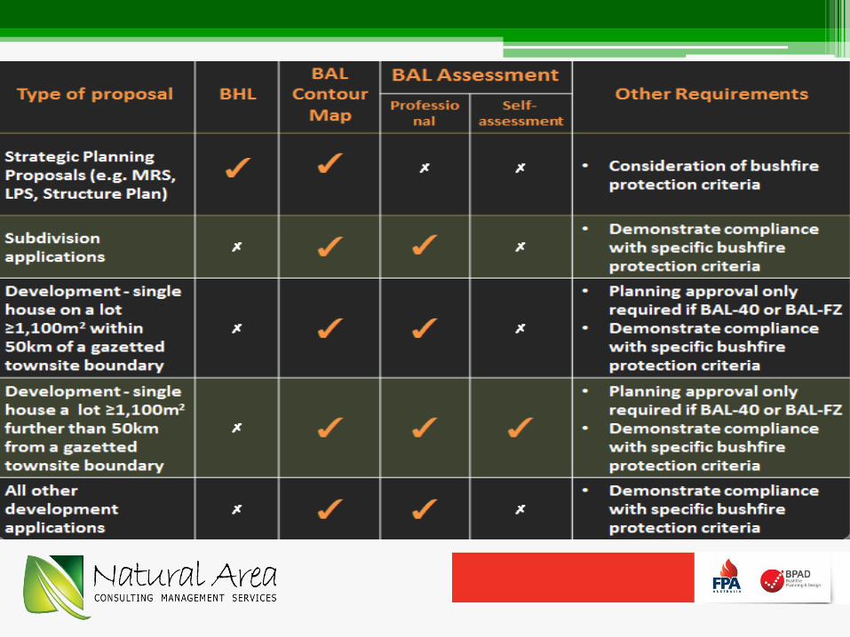
Bushfire Prone Mapping Bushfire prone area means land designated by an
order made under Section 18P of the Fire and Emergency Services Act 1998
Designation undertake by Office of Bushfire Risk Management (OBRM)
Online December 2015, updated May 2016


SPP 3.7 Councils must have due regard to the
policy, or they must give respect and consideration to it
Requires consideration of bushfire hazard at various stages of the planning process
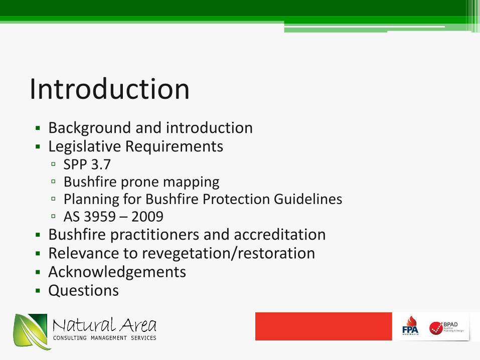
Common outputs of the process: ▫ Bushfire Hazard Assessment ▫ BAL-contour map and BAL-assessment ▫ Bushfire Management Plan
SPP 3.7
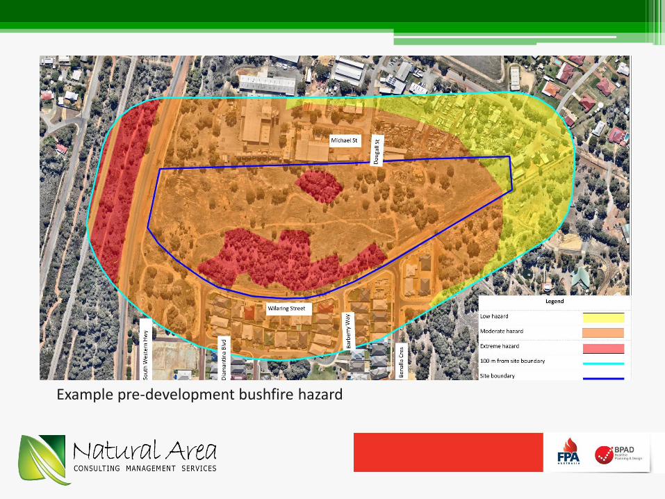
Bushfire Hazard Assessment
Example pre-development bushfire hazard

BAL-Contour, BAL-assessment BAL = bushfire attack level Considers the presence of bushland areas (classified vegetation)
and its proximity to urban development, along with vegetation type and slope
Majority of house fires in proximity to bushland are within 100 m of the vegetated areas
Bushfire hazard considers the separation distance to building walls and associated risks of smoke, ember attack and flames
Scale map of a development site including proposed lot layout and indicative BAL-ratings; indicates potential bushfire attack levels and radiant heat impacts, thus identifies land suitable and unsuitable for development

BAL Construction Levels


Bushfire Protection Criteria Performance-based system of assessing bushfire
risk management measures Consists of four elements
- 1 – Location - 2 – Siting and design of development - 3 – Vehicular access - 4 – Water
Each has an intent that outlines the desired outcomes for the element (performance principle and acceptable solutions)
Assessment typically documented in a Bushfire Management Plan

Bushfire Protection Criteria
Element 2 – Siting And Design • Asset Protection Zone – minimum 20 m.
Where 20 m not possible, APZ sufficient enough to ensure potential radiant heat impact of a fire does not exceed 29 kW/m2.
Element 3 – Vehicular Access • Two access routes • Technical requirements for:
• Public road • Cul-de-sac • Battle Axe • Private driveway >50 m • Emergency access way • Fire service access routes.
Element 4 – Water • Reticulated water supply, or • Provision of water tanks for fire
fighting purposes.
Element 1 – Location
Development is located in an area that is or will, on completion, be subject to either a moderate or low bushfire hazard level, or BAL-29 or below.

Implications for Revegetation
Development will result in clearing of vegetation and also the landscaping and/or revegetation
Revegetation can create areas of classified vegetation that can impact on the various bushfire assessments and the need for a building to have a BAL-rating
Important to consider revegetation in early stages of the planning process
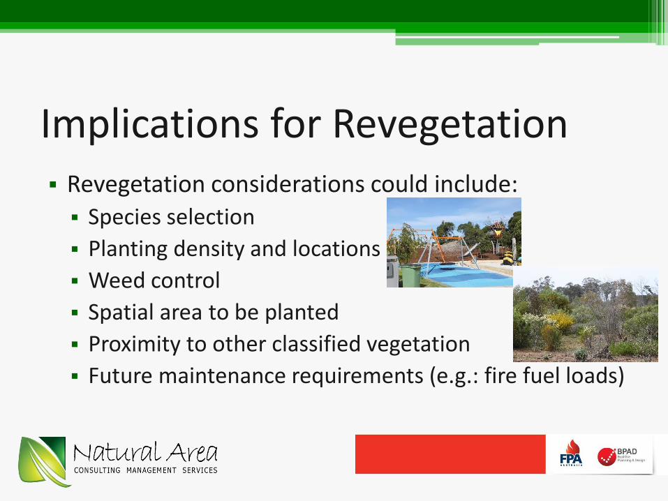
Implications for Revegetation Revegetation considerations could include:
Species selection
Planting density and locations
Weed control
Spatial area to be planted
Proximity to other classified vegetation
Future maintenance requirements (e.g.: fire fuel loads)

Revegetated POS

Key Messages
Bushfire implications need to be considered early in the planning process
Landscaping and revegetation activities also need to be considered early due to their potential impacts on BAL-ratings within a subdivision
Acknowledgements
Chris Wyborn, Engagement and Education Manager, Fire Protection Association of Australia

Questions? Presenter:
Sue Brand
Senior Environmental Scientist
Natural Area
Natural Area:
Head Office
99c Lord Street, Whiteman
Perth WA, 6068
P 08 9209 2767
www.naturalarea.com.au