Embed Size (px)
Citation preview
Wahwashkesh-Naiscoot
Conservation Reserve (C326)
Statement of Conservation Interest March 2004
i
Wahwashkesh-Naiscoot Conservation Reserve
(C326)
Statement of Conservation Interest
Ministry of Natural Resources Parry Sound District
Prepared with the assistance of: Meteek & Company Huntsville, Ontario
March 2004
ii
Approval Statement We are pleased to approve this Statement of Conservation Interest for Wahwashkesh-Naiscoot Conservation Reserve (C326). Wahwashkesh-Naiscoot Conservation Reserve is a 1,734 hectare area of Crown land in Burton Ward of the Municipality of Whitestone, and in Harrison Ward within the Township of The Archipelago, in the Territorial District of Parry Sound. This site extends about 25 kilometres along scenic shorelines of several lakes, from Naiscoot Lake in the west to just west of Wahwashkesh Lake in the east. The chain of lakes that extends across the length of this conservation reserve is a part of a long-standing popular canoe route with linkages to the Magnetawan River. This conservation reserve is within ecological Site District 5E-7 and provides representation of a southern Ontario Canadian Shield landscape of predominantly pine and birch forests and gneiss and granite outcrops. The area is used for a variety of traditional uses, including canoeing, camping, hunting, and fishing. Wahwashkesh-Naiscoot Conservation Reserve is one of 378 new protected areas approved through Ontario’s Living Legacy Land Use Strategy, aimed, in part, at completing Ontario’s system of parks and protected areas. During the “Lands for Life” planning process, the public was widely consulted and provided valuable input into what became Ontario’s Living Legacy Land Use Strategy. Prior to and during consultation related to the formal Public Lands Act regulation of the boundaries of this conservation reserve (in 2002) a number of minor boundary changes were made to reduce resource management conflicts, and to ensure the boundaries reflected areas requiring protection. Comments received during the consultation were generally supportive of the protection of this area. Stakeholders who provided comment during the earlier consultation for this site were subsequently consulted regarding the draft Statement of Conservation Interest and their comments were considered in the finalization of this document. This Statement of Conservation Interest provides guidance for the management of the conservation reserve and provides the basis for the ongoing monitoring of activities. More detailed direction is not anticipated at this time. Should more complex resource management or conservation issues arise or significant facility development be considered, then a detailed Resource Management Plan will be prepared with full public consultation. Wahwashkesh-Naiscoot Conservation Reserve is managed under the direction of the District Manager and the Parry Sound Area Supervisor of the Ministry of Natural Resources, Parry Sound District. Approved by: R. Griffiths
District Manager Parry Sound District
Approved by: Ron Running
Regional Director Southern Region
iii
Table of Contents
APPROVAL STATEMENT ....................................................................................................................... II
1.0 INTRODUCTION ................................ ................................ ................................ ............................3
1.1 BACKGROUND INFORMATION: ...............................................................................................................4 1.2 REPRESENTATION: .............................................................................................................................4 1.3 SURVEY WORK:.................................................................................................................................5
2.0 VALUES TO BE PROTECTED .......................................................................................................5
2.1 EARTH SCIENCE:................................................................................................................................5 2.2 LIFE SCIENCE: ...................................................................................................................................6 2.3 CULTURAL VALUES: ................................ ................................ ................................ ............................8 2.4 RECREATIONAL/AESTHETIC VALUES:.....................................................................................................9
3.0 MANAGEMENT GUIDELINES ........................................................................................................9
3.1 LAND TENURE: ..................................................................................................................................9 3.2 DEVELOPMENT: ...............................................................................................................................11 3.3 RECREATIONAL ACTIVITIES : ...............................................................................................................12 3.4 COMMERCIAL ACTIVITIES: ................................ ................................ ................................ ..................14 3.5 ABORIGINAL INTERESTS: ...................................................................................................................15 3.6 NATURAL RESOURCE STEWARDSHIP: ................................ ................................ ................................ ..15 3.7 CULTURAL RESOURCE STEWARDSHIP: ................................................................................................16 3.8 CLIENT SERVICES: ...........................................................................................................................16 3.9 RESEARCH: .....................................................................................................................................17 3.10 MARKETING: ................................ ................................ ................................ ................................ ..17
4.0 IMPLEMENTATION......................................................................................................................17
5.0 REVIEW AND REVISION OF THE STATEMENT OF CONSERVATION INTEREST ........................18
6.0 REFERENCES .............................................................................................................................19
APPENDICES ........................................................................................................................................20
APPENDIX 1 PROCEDURAL GUIDELINE B – LAND USES – ................................ ................................ ..........20 APPENDIX 2 INDICATOR USES FOR CONSERVATION RESERVES: .................................................................21 APPENDIX 3 PROCEDURAL GUIDELINE C ................................................................................................23 APPENDIX 4 RECREATION CAMP TENURE...............................................................................................24
Table of Figures Figure 1: Location of Wahwashkesh-Naiscoot Conservation Reserve (C326) ........................................1 Figure 2: Site Map – Wahwashkesh-Naiscoot Conservation Reserve (C326) ..........................................2
1
Figure 1: Location of Wahwashkesh-Naiscoot Conservation Reserve (C326)

2
Figure 2: Site Map – Wahwashkesh-Naiscoot Conservation Reserve (C326)
3
1.0 Introduction Ontario’s Living Legacy, the result of an extensive planning process that began in early 1997, culminated in the approval in July 1999 of a Land Use Strategy that identifies the intended strategic direction for Crown land, including the completion of Ontario’s system of parks and protected areas. This process, which included extensive public consultation, resulted in the recommendation for regulation of 378 new protected areas, including Wahwashkesh-Naiscoot Conservation Reserve (C326). Wahwashkesh-Naiscoot Conservation Reserve is a 1,734 hectare area of Crown land that extends from just west of Wahwashkesh Lake to Naiscoot Lake, approximately 1½ kilometres east of the current Highway 69. Its western limits are approximately 5½ kilometres north of the hamlet of Pointe au Baril Station and approximately 44 kilometres north west of the Town of Parry Sound. The eastern portion of the site is located in Burton Ward of the Municipality of Whitestone, while the western part lies in Harrison Ward within the Township of The Archipelago, in the Territorial District of Parry Sound. Wahwashkesh-Naiscoot Conservation Reserve is linked to Naiscoot Forest Conservation Reserve (C116) in the west, and Magnetawan River Provincial Park (P316) to the north-west. It lies about 1 kilometre north of Oxbow Lake Forest Conservation Reserve (C50). Part of the conservation reserve lies within a Restricted Access Area, as identified in the 1983 Parry Sound District Land Use Guidelines. With the approval of the Ontario’s Living Legacy Land Use Strategy – 1999 the Restricted Access Area policies were carried forward into the Land Use Strategy and continue to apply within much of the conservation reserve. Adjacent to the conservation reserve, the former Restricted Access Area is now within Parry Sound Interior Enhanced Management Area (E104a). The intent of both the Restricted Access Area and Parry Sound Interior Enhanced Management Area is to maintain the remote access characteristics of the vicinity. The Crown lands adjacent to the western end of the conservation reserve are within a Recreation Enhanced Management Area (E119r). The intent of that land use designation is to provide for semi-remote recreation, access, natural resource protection and extraction. Along the length of this site, there are numerous adjacent private land parcels that are not a part of the conservation reserve. The municipal road allowances, including shore road allowances, within the Municipality of Whitestone are excluded from the conservation reserve. Wahwashkesh-Naiscoot Conservation Reserve is relatively narrow, being focussed on the waterways and adjacent shorelines. It extends back from the water’s edge either 90 metres or 120 metres, depending on the location. This conservation reserve is within Hills’ ecological Site District 5E-7 and provides representation of a southern Ontario Canadian Shield landscape of predominantly pine and birch forests and gneiss and granite outcrops. The chain of lakes that extends across the length of this conservation reserve is a part of a long-standing popular canoe route with linkages to the Magnetawan River. The area is used for a variety of traditional uses, including canoeing, camping, hunting, and fishing. Conservation reserves are established under the authority of the Public Lands Act, Ontario Regulation 805/94. Wahwashkesh-Naiscoot Conservation Reserve was established by Ontario Regulation 237/03 on June 28, 2003. A Statement of Conservation Interest (SCI) is prepared under the direction of Procedural Guideline A – Resource Management Planning (PL. Procedure 3.03.05). The purpose of this SCI is to identify and describe the values of Wahwashkesh-Naiscoot Conservation Reserve. The SCI also outlines the activities that currently occur within the conservation reserve and provides guidelines for the management of current and future activities in the context of protecting the natural, recreational and cultural values.
4
1.1 Background Information:
Name
Wahwashkesh-Naiscoot Conservation Reserve (C326)
Site Region/District 5E-7
OMNR Administrative Region/District/Area Southern Region/Parry Sound District/ Parry Sound Area
Total Area (ha.) 1,734 hectares
Regulation Date June 28, 2003 (O. Reg. 237/03)
First Nations Robinson-Huron Treaty and Williams Treaty
OBM map sheets 10 17 5500 50500, 5550 50500, 5550 50550, 5600 50550, 5650 50550, 5700 50550,
Topographic Map Pointe Au Baril Station 41 H/9
UTM co-ordinates 17T 56280 505630 (Centroid)
1.2 Representation: Earth Science Representation: Bedrock -- Five units of the Britt Domain are present (Bayfield and Nadeau Island gneiss associations,
Shawanaga granodiorite, Bolger pluton and the Central Britt shear zone). This site presents a 25 kilometre cross-section of the Britt Domain, Algonquin Terrane in the Proterozoic Central Gneiss Belt of the Grenville Province.
Surficial -- Bedrock knobs and plains characterize the area. Thin discontinuous drift overlies bedrock,
with patches of ice-contact deposits in low lying areas.
Life Science Representation: This site provides representation of a southern Canadian Shield landscape of predominantly pine and birch forests, and gneiss and granite outcrops. Cultural Resources Representation: Neither detailed cultural research nor inventory has been carried out for this conservation reserve. Recent regional evaluation (OMNR, 2003) shows that this conservation reserve contains areas that have a high potential for cultural heritage sites and historic travel routes. Recreational Opportunities: A recreational inventory report was prepared for this site based primarily on existing knowledge and data sources of MNR staff, recent site visits, and also reflecting field observations made during the preparation of the life science report (Larson, 2003). The area is recognized as providing many recreation opportunities. It accommodates big and small game hunting, canoeing, camping, and sport fishing. A snowmobile trail crosses each end of this conservation reserve. A Trans Ontario Provincial (TOPS) Trunk snowmobile trail crosses
5
Naiscoot Lake at the west end of this site, and a TOPS feeder trail crosses between Mud and Wahwashkesh Lakes on the east side. 1.3 Survey Work: Survey Level
Earth Science
Life Science
Cultural
Recreational
Other
Reconnaissance Blackburn, 2003 Jones, 2003 OMNR, 2003 Larson, 2003 None
Detailed None None None None None
Requirement None
Monitor the status/presence of significant species and associations.
Research to be encouraged. Monitor use impacts None
2.0 Values to be protected This conservation reserve is located within Hills’ (1959) ecological Site District 5E-7. Values include earth science, life science and recreational/aesthetic values, with an emphasis on the life sciences. 2.1 Earth Science:
(Earth science information, unles s otherwise noted, is taken from Blackburn, 2003) Bedrock:
Wahwashkesh-Naiscoot Conservation Reserve is an area of extensive bedrock barrens interspersed with numerous lakes, interconnecting drainages and wetlands. The dominant rock types exposed are Whitestone Suite meta-anorthosite in the western part of the Britt Domain, Algonquin Terrane in the Proterozoic Central Gneiss Belt of the Grenville Province. The Grenville Province is the product of thrusting and imbrication of the crust to the northwest as it collided with a continental landmass to the southeast. The Grenville Orogeny, circa 1140 to 1070 million years ago, culminated more than 500 million years of crustal evolution. The eroded roots of the products of these events are displayed in the complexly metamorphosed and deformed rocks of the region (Easton, 1992b). The Algonquin Terrane is one of the four lithotectonic terranes of the Central Gneiss Belt. Within the Algonquin Terrane, the Britt Domain is one of twelve structural domains. These geological environments are part of the modern organization of the complex products of the mid-Proterozoic orogenic events (Easton 1992a & b). As such, their representation in this conservation reserve contributes to the conservation of the Grenville Province continental accretion theme (Davidson, 1981). The Britt Domain consists of highly deformed 1.8 to 1.6 billion-year-old gneisses and migmatites of supracrustal and igneous origin that have been intruded by younger 1.5 to 1.4 billion-year-old granitic and monzonitic plutons. Structural trends of the Britt Domain vary. West of Highway 69, the dominant trend is north-westerly. East of Highway 69, the structural trend changes to a northerly to north-easterly direction. This conservation reserve makes a 25 kilometre cross-section at right angles across the dominantly northerly structural trend of the lithographic and tectonic units of the Domain. From west to east these are: the Bayfield gneiss association; the Central Britt shear zone; Nadeau Island gneiss association; Shawanaga granodiorite; an area of unsubdivided gneisses; the Bolger pluton; and another area of unsubdivided gneisses.
6
Taken together with the adjacent Naiscoot Forest Conservation Reserve, a 25 kilometre cross section of the Britt Domain is represented in an inland central portion. With further mapping they have potential to give a better understanding of the complex geological relationships within this domain. However, at present, the bedrock geological features of Wahwashkesh-Naiscoot Conservation Reserve are considered to have only local significance in their representation of the Britt Domain, Algonquin Terrane. Surficial:
Wahwashkesh-Naiscoot Conservation Reserve lies in the Georgian Bay fringe physiographic region of Southern Ontario characterized by very shallow soil and bare bedrock knobs and ridges (Chapman & Putman, 1984). Thin discontinuous drift overlies bedrock in places and very small patches of ice-contact deposits have been mapped in lower lying areas close to shorelines. No significance is attributed to these surficial geological features. 2.2 Life Science: (Life science information, unless otherwise noted, is taken from Jones, 2003) Representation: Because of its length and size and the presence of both aquatic and terrestrial habitats, Wahwashkesh-Naiscoot Conservation Reserve is a varied, diverse site. Three vegetation types are predominant in the conservation reserve: 1) mature to old white pine (Pinus strobus)-dominated forest, with red pine (Pinus resinosa) and
somewhat younger red oak (Quercus rubra) and/or red maple (Acer rubrum) present, occurring on the dry, rocky slopes above the shoreline;
2) at the water's edge a narrow strip of shrubs a few meters wide, dominated by sweet gale (Myrica gale) with alder (Alnus rugosa) and royal fern (Osmunda regalis) occurring on small, broken chunks of bedrock;
3) moving out into the water, the shrubs grade into an aquatic community dominated by pickerel weed (Pontederia cordata) and water lily (Nymphaea odorata).
In addition to the predominant white pine forest, occasional patches of hemlock (Tsuga canadensis) forest exist at Miskokway Lake, and cedar (Thuja canadensis) groves are common along the shores of Horseshoe Lake. Deciduous forests occur in several places. At Miskokway Lake, the predominant forest is white birch (Betula papyrifera) with large-toothed aspen (Populus grandidentata), white pine or sugar maple as components and an understory of bracken fern (Pteridium aquilinum ). The east side of Horseshoe Lake also supports this same forest type. The south shore of Miskokway has a rich, sugar maple-dominated forest with basswood (Tilia americana) present. This area has a great diversity of fungi. In the corridor between Wilson Lake and the small lake south of Miskokway Lake, forests dominated by white birch, and large-toothed aspen, or red oak (Quercus rubra) occur on north-facing slopes with mesic soils. These forests have a ground flora of cinnamon fern (Osmunda cinnamomea) and New York fern (Thelypteris novebor acensis). Some of this corridor has intense regeneration of young white pine and red maple in the understory. The south shore of the narrows between Wilson and Little Wilson Lakes supports a small area of mesic forest of white birch, sugar maple and black ash in a drainage valley. At Bolger Lake, along with the typical white pine forest, there are examples of well developed sugar maple-white birch forest with sugar maple seedlings mostly making up the understory, but with a large number of other species present. The connection between Miskokway and Bolger lakes supports medium to younger-aged sugar maple-dominated forest. This area is bisected by the transmission line corridor and roads. In addition, many kinds of wetlands and aquatic communities occur in places where the shoreline provides a small bay or indentation in the bedrock. Aquatic vegetation is especially well developed in a protected inlet off the northern shore of Naiscoot Lake at the western end of the conservation reserve. The head of Horseshoe Lake supports the biggest example of the shoreline shrub community, dominated by sweet gale with three-
7
way sedge (Dulichium arundinaceum) and Robbin's spike-rush (Eleocharis robbinsii). Miskokway Lake has wet, muddy areas with swamp candles (Lysimachia terrestris) and aquatic sedge (Carex aquatilis), as well as a large alder thicket swamp present at the eastern end. Bolger Lake has a great variety of wetlands including fens dominated by Virginia chain fern (Woodwardia virginica); rich fen-like vegetation on shallow mud mats with white beak-rush (Rhynchospora alba) and horned bladderwort (Utrichularia cornuta); low shrub thicket-swamp dominated by leatherleaf (Chamaedaphne calyculata), alder, and mountain holly (Nemopanthus mucronatus); as well as the typical shoreline and aquatic vegetation already outlined. The small lake southwest of Miskokway Lake in the corridor to Wilson Lake has a muddy pond shore dominated by leatherleaf and three-way sedge with sundews (Drosera rotundifolia and D. intermedia) and bladderworts (Utricularia spp.). A further aquatic community might be the algal colonies which occur as distinct green clouds in the water at the east end of Bolger Lake. Several species are present in the conservation reserve that are components of the provincially rare Atlantic Coastal Plain marsh vegetation type, including buttonbush (Cephalanthus occidentalis), meadow-beauty (Rhexia virginica) and Robbin's spike-rush. While these species were occasionally seen in large quantities individually, they were not observed together in sufficient quantity to merit designation as this community type. Rocky ledges and steep walls of bedrock occur in the narrows of Miskokway Lake, with white cedars managing to grow out of the cracks. The ledges also supported a few plants of spikenard (Aralia racemosa) not seen elsewhere in the conservation reserve. The steep slopes of broken talus at the north end of Wilson Lake were the only major site for poison ivy (Rhus radicans ), growing with sparse vegetation and scattered, stunted white birches. Finally, some areas of the shoreline, especially on Miskokway and Bolger Lakes have patches of open rock barren on top of bedrock knobs. These have a cover of poverty grass (Danthonia spicata), wavy hairgrass (Deschampsia flexuosa), and blueberry (Vaccinium angustifolium) as well as reindeer lichens (Cladina rangiferina and C. mitis), with up to 30% of the area being bare rock with crustose lichens. The eastern-most part of the site was not visited in the 2003 survey (from Kashegaba to Maple and Mud Lakes); however, from aerial photography it is inferred that the south shore of Kashegaba Lake will have the younger mixed forests of white birch, white pine, white spruce and red maple, very similar to what is found at Bolger Lake. The corridor from Kashegaba Lake to Maple Lake appears to have some very large alder thicket swamps surrounded by uplands with open rock barrens. The wetlands on the shores of Cat and Bear Lakes appear to be shrub thicket swamps of sweet gale and leatherleaf or mountain holly. The larger wetlands on the shores of Mud Lake are most likely combinations of alder thicket swamp, shrub thicket swamps, and areas of open shoreline fen similar to what is found at Bolger Lake on shallow muddy mats. The connection between Mud Lake and Maple Lake also appears to be a combination of shrub and alder thicket swamps. Maple Lake appears to be a deeper lake with a dryer shoreline with sugar maple forest and with shallow aquatic vegetation in the bays on the east side. Condition: Very old burnt stumps and charred wood fragments are present in the dry white pine -dominated forest on the slopes, evidence of past fires. However, much of the predominant white pine-conifer forest is in mature to old stages with some very large pines present, indicating that there have been no major fires for a long time. OMNR digital fire history mapping shows no documented fire in the area. None of the deciduous forests show any evidence of past burning, and some have very large trees present. Fire does not appear to have had any influence on the mesic forests of this conservation reserve in recent history. Little evidence remains of logging that occurred around the 1880s. The forests of the conservation reserve show almost no evidence of anthropogenic disturbance. Roads within the site are limited to the roads to Miskokway and Bolger Lakes. As well there are narrow portage trails between Wilson and Miskokway Lakes and between Wahwashkesh Lake and Maple and Mud Lakes. Most of the conservation reserve is accessible only by water or by air.
8
Diversity: Twenty nine landform-vegetation types were documented during the 2003 site inspection. These vegetation types were defined using standard ecological land classifications of Ontario (Chambers et al. 1997, Lee et al. 1998, NHIC 2002 and Harris et al. 1996) which have been applied to create a complete classification for the greater Georgian Bay area by Jalava et al. (2002). The conservation reserve is notable for its diversity of both terrestrial and wetland community types, but variations in shoreline features—depth of water, substrate, shaded or not, etc., especially give rise to the diversity of aquatic community types. These communities provide habitat for at least 174 vascular plant species. Ecological considerations: Wahwashkesh-Naiscoot Conservation Reserve and the Naiscoot River system in general are connected to the waters of Magnetawan River Provincial Park and Noganosh Lake Provincial Park, as well as to other lakes and rivers to form part of a very large network of aquatic habitats. Special Features: The conservation reserve provides a large area of inland habitats for the eastern massasauga rattlesnake. It also has a high potential to contain habitats for the five-lined skink and Atlantic Coastal Plain flora species. The following Provincially Rare species were noted during the 2003 survey: • Eastern massasauga rattlesnake (Sistrurus catenatus catenatus); Threatened (COSEWIC and OMNR).
Two recent sightings at Miskokway Lake. • Marsh St. John's wort (Triadenum virginicum); a few plants on the edge of a shoreline fen at Bolger Lake. • Carey's smartweed (Polygonum careyi); 7 plants present at the edge of the muddy alder thicket at the
eastern end of Miskokway Lake. • Meadow beauty (Rhexia virginica); common in the fen-mud mats at Bolger Lake. Locally significant species include: • Robbin’s spike-rush (Eleocharis robbinsii); common in the marsh at the outflow at the east end of Evans
Lake. • Pine sap (Monotropa hypopithys); a few plants in dry pine forest, Miskokway Lake. • Interrupted fern (Osmunda claytonii); local on the shore of Miskokway Lake. • Northern snailseed pondweed (Potamogeton spirillus); local in shallow water in a protected inlet on north
side of Naiscoot Lake. • Slender beak-rush (Rhynchospora capillacea); local on the shore of Miskokway Lake and at the edge of a
fen on shore of Bolger Lake. There is a white-tailed deer wintering area that touches on the south shore of Bolger Lake. Miskokway Lake is one of the few self-sustaining and naturally reproducing lake trout lakes in the Parry Sound Area and one of the premier lake trout lakes in Parry Sound District. 2.3 Cultural Values: While no specific cultural studies or inventories have been undertaken within the conservation reserve, and no major cultural resource values have been evaluated or identified to date, there is evidence of early logging (circa 1880) throughout this conservation reserve. Recent regional evaluation (OMNR, 2003) shows that this conservation reserve contains areas that have a high potential for cultural heritage sites. It is highly likely that the water routes within and connected to this conservation reserve were used as transportation corridors by aboriginal peoples and fur traders prior to the logging days (Larson, 2003). The proximity of this area to two historically significant rivers, the Magnetawan and the Shawanaga Rivers, both having a direct connection to Georgian Bay, lends credence to this speculation.
9
The Canadian National Railway line that crosses through the conservation reserve had a station at Bolger Lake (Bolger Station – which closed in the late 1970s) and most of the private land in the vicinity stems from the associated settlement. 2.4 Recreational/Aesthetic Values: (Recreation information, unless otherwise noted, is taken from Larson, 2003) This conservation reserve is a popular recreation area composed largely of scenic shorelines. The waterways and interconnecting land routes and portages are integral parts of long standing canoe routes. Canoeing and related camping are actively pursued in this conservation reserve. The conservation reserve is easily accessed from Highway 69, located roughly 1½ kilometres west of the western boundaries enabling easy boat access to Naiscoot Lake, Little Wilson Lake and Wilson Lake, including motorboats. There is public access adjacent to the highway at present, as well as a nearby marine. Rough road access to Miskokway Lake and Bolger Lake and the presence of private camps and cottages results in motorboat use on additional lakes. Float planes also provide access to the lakes of this conservation reserve, for a variety of activities. The seven major lakes and numerous smaller lakes included in the conservation reserve are inhabited by a variety of sports fish species, and fishing is a popular activity in the conservation reserve and its adjacent waters. Hunting has also traditionally occurred within the conservation reserve boundaries. Small game and waterfowl hunting is frequent, however the majority of hunting activity is focused on large game species, namely white-tailed deer (Odocoileus virginiana), moose (Alces alces), and black bear (Ursus americanus). There are six authorized Crown land recreation camps within the conservation reserve. Private landowners in the immediate area as well as some portable hunt camps use the waterway to access hunting territory. A Trans Ontario Provincial (TOPS) Trunk snowmobile trail crosses Naiscoot Lake on the western boundary of Wahwashkesh-Naiscoot Conservation Reserve, and a TOPS feeder trail crosses the conservation reserve just east of Mud Lake. Some pre -existing unauthorized trails criss-cross in and out of the conservation reserve, such as between Naiscoot and Wilson Lake, and from Carson Lake to Bolger Lake. The hydro-line road which crosses the conservation reserve between Bolger and Miskokway Lakes has been a traditional source of access to surrounding Crown land for a variety of recreational activities, including dirt biking, all-terrain vehicle travel, snowmobiling, trail biking, and hiking. This is a very rugged, rough road. Areas of the conservation reserve receive light to moderate use by local and seasonal residents for hiking, cross-country skiing, and snowshoeing. The distance of this conservation reserve from urban areas has resulted in a relatively pristine night sky, which enhances the sense of remoteness and wilderness of this site. Pristine night skies are considered a significant value, given the increasingly limited areas of southern and central Ontario which are not heavily affected by light pollution.
3.0 Management Guidelines 3.1 Land Tenure: Background: Wahwashkesh-Naiscoot Conservation Reserve comprises 1,734 hectares of Crown land, along a series of waterbodies. Most of the surrounding lands are Crown; however, there are pockets of privately owned lands on Portage Bay, Bolger Lake, Miskokway Lake and Naiscoot Lake. These lands are not part of the conservation reserve and will remain privately owned.
10
Road allowances in the Burton Ward portion of the conservation reserve remain under the authority of the Municipality of Whitestone wherein they lie, and are not included as part of the conservation reserve. Canadian National Railway corridor crosses Bolger Creek at the site of the former Bolger Station. Its right -of-way abuts but is not within the conservation reserve boundary. The conservation reserve is divided between two OMNR Bear Management Areas (PS-49-001, and PS-49-003). A portion of the conservation reserve is not within a Bear Management area, including a portion of the east part of Naiscoot Lake, and the north side of Little Wilson and Wilson lakes across to the west side of Miskokway Lake. There are also six OMNR registered traplines that have port ions of their harvest areas within the conservation reserve. West to east, they are PS-155, PS-157, PS-156, PS-72, PS-70 and PS-73. The conservation reserve lies within parts of four commercial Bait Fish Blocks (PS0028, PS0029, PS0035 & PS0036). There are three authorized recreation camps within the conservation reserve. The Ontario Federation of Snowmobile Clubs Trans Ontario Provincial (TOPS) Trunk Trail crosses Naiscoot Lake at the western boundary of the conservation reserve. A TOPS feeder trail crosses the conservation reserve at the east end, by way of a bridge across Mud Creek. A land use permit authorizes an emergency helicopter landing pad on Lot 15, Concession 5, Burton Ward on the shore of Bolger Lake. A Hydro One high voltage power transmission corridor along with its associated service road crosses the conservation reserve between Miskokway and Bolger Lakes.
Guideline: The sale of Crown lands within the conservation reserve generally is not permitted. Exceptions will only be consider ed under unusual circumstances, such as where an adjacent privately owned parcel has inadequate area for the installation of a septic system. There are no plans by the MNR to acquire private lands to add to the conservation reserve. MNR is prepared to consider authorization to the local cottagers’ association to manage a parking area on Crown land at the access point to Bolger Lake. The commercial bear hunting services associated with the current Bear Management Areas are allowed to continue. However they are not allowed in the remainder of the conservation reserve, and additional areas of the conservation reserve cannot be incorporated into a Bear Management Area. Fur harvest is permitted to continue in the registered trapline areas. The Bait Fish Blocks are permitted to continue. The existing recreation camps within the conservation reserve are permitted to continue. They may be eligible for “enhanced” tenure, but are not eligible for purchase of land (See Appendix 4). New recreation camps are not permitted. The two authorized snowmobile trails continue to be authorized, but their use will be monitored to ensure that conservation reserve values are not being adversely impacted. The existing authorized emergency helicopter landing pad is allowed to continue. The Magnatawan Pioneer Association (the permit holder) may apply to develop an alternative site to enable night landings. If such a site is developed, the authorization of the current site will be discontinued.
11
The Hydro One power transmission corridor is recognized as an accepted existing use. Changes to this transmission corridor, such as the additions of additional tower lines, must meet the requirements of Procedural Guideline B – Land Uses – Test of Compatibility (see Appendix 1). Commercial timber harvesting is not allowed within conservation reserves. However, there are limited situations in which abutting land owners can harvest firewood for use on their adjacent property. Specifically, property owners and those with Crown land tenure who have no road access to their properties can apply for permits to cut limited amounts of firewood in the conservation reserve for their own use. This situation would apply only to authorized recreation camps and water access cottages/camps that are adjacent to conservation reserve boundaries. Because this conservation reserve is only 90 to 120 metres deep for most of its length, such permits are likely to apply to adjacent Crown land, but not within the conservation reserve itself. 3.2 Development: Background: There are no Crown owned buildings or other facilities within the conservation reserve. As described above in the discussion of Land Tenure, there are two snowmobile trails that touch or cross conservation reserve boundaries. The western TOPS trunk trail crosses Naiscoot Lake over the ice. The eastern TOPS feeder trail uses a bridge to cross Mud Creek. As provided for under the 1999 Ontario Forest Accord, three new forest access roads and water crossings have been approved which will cross conservation reserve boundaries, at some future time. These will be located: 1) at the east end of Mud Lake in Burton Ward; 2) west of Bolger Lake and east of the hydro lines, running north from the existing trail between Miskokway
and Bolger Lakes; and 3) across the portage between Wilson and Miskokway Lakes. A Hydro One power transmission line crosses through the conservation reserve between Miskokway and Bolger Lakes. An associated maintenance and service road also crosses the conservation reserve nearby. There are no other authorized recreation trails within the site, although there is known to be some use of the area by all-terrain vehicles, snowmobiles, hikers, cross-country skiers and snowshoers. Consistent with the intent of the Restricted Access Area, as identified in the Parry Sound District Land Use Guidelines (OMNR, 1983), and Parry Sound Interior Enhanced Management Area (E104a), these forest access roads and approved water crossings are for forest harvest and forest management purposes, and will not be open for public access. The central and eastern portions of the conservation reserve are within a pre-existing Restricted Access Area, as identified in the 1983 Parry Sound District Land Use Guidelines. The adjacent Crown lands are within Parry Sound Interior Enhanced Management Area (E104a) where access is also restricted. The western portion of the conservation reserve is adjacent to a Recreation Enhanced Management Area (North Parry Sound Enhanced Management Area – E119r). The intent of that land use des ignation is to provide for semi-remote recreation, access, natural resource protection and extraction. Guideline: Other than the agreed to forest access roads described above, new roads for resource extraction and/or private use will not be permitted, nor will additions to existing roads, or upgrading of existing roads be permitted. There is no intention to develop roads outside of the conservation reserve to improve access to this site. Consistent with the intent of the Restricted Access Area, as identified in the Parry Sound District Land Use Guidelines (OMNR, 1983), and the adjacent Parry Sound Interior Enhanced Management Area
12
(E104a), the three potential forest access roads and approved water crossings are for forest harvest and forest management purposes, and will not be open for public access. In general, existing authorized recreational trails may be permitted to continue in conservation reserves as long as they do not impair the natural features and values for which the area is identified and as long as there are no significant environmental impacts. Accordingly, the authorized snowmobile trails continue to be authorized, but their use will be monitored to ensure that conservation reserve values are not being adversely impacted. Consistent with the intent of the Restricted Access Area and Parry Sound Interior Enhanced Management Area (E104a) new recreation trails will not be permitted in the central and eastern part of this conservation reserve. Consistent with the management intent of the Recreation Enhanced Management Area which surrounds the western part of this site, new recreational trails may be considered on a case by case basis provided that they meet Procedural Guideline B – Land Uses – Test of Compatibility (see Appendix 1) and the MNR’s Environmental Assessment Act requirements. Public consultation will generally be required during the consideration of changes to existing trails, and will always be required for new trails. New recreational trails for motorized vehicles will not be permitted, unless the following have been demonstrated:
• there is a community need for the trail, as well as community support; • there are no alternative suitable locations outside the conservation reserve; • the trail location would be acceptable and suitable for four-season use; • the trail would meet the requirements applicable to all trails, as identified in the preceding paragraph.
The use of unauthorized recreation trails that were existing at the time of regulation of this conservation reserve, and the increase in use of all-terrain vehicles, will be monitored to ensure that conservation reserve values are not being adversely impacted. Depending on the results of monitoring, some of the unauthorized trails may need to be redirected from sensitive areas or eliminated completely. Otherwise, there is no intent to mark or upgrade these trails. Unauthorized works within the conservation reserve will be handled in accordance with the Public Lands Act, and any required removal of improvements will be at the expense of those responsible. The development of new docks and water systems for adjacent or surrounded private lands is not restricted by the establishment of the conservation reserve. The MNR will consider site specific values when a work permit is required for such work. No mineral exploration is permitted within this conservation reserve. This policy decision is based on a commitment made by the Ministry of Natural Resources and the Ministry of Northern Development and Mines in March 2002. This policy direction replaces that identified in the 1999 Ontario’s Living Legacy Land Use Strategy, which stated that controlled mineral exploration would be permitted in new conservation reserves which were identified as having provincially significant mineral potential. Any new development must meet MNR’s commitments to protect cultural heritage values (see Section 3.7). While there is no intent at present to provide or permit any new development in this conservation reserve that would require lighting, should this be considered at some point in the future the MNR will not allow unnecessary, undirected light pollution. This commitment recognizes the wilderness values provided by a pristine night sky. 3.3 Recreational Activities: Background: The scenic waterways with accessible lakes and traditional canoe routes are popular for canoeing, boating and angling. Camping related to water travel occurs on scattered campsites.
13
Hunting is a traditional activity within the conservation reserve. Small game and waterfowl hunting are frequent, however hunting activity is mainly focussed on large game species, namely white-tailed deer, moose and black bear. There are three authorized Crown land recreation camps within the conservation reserve. Private landowners in the immediate area as well as some portable hunt camps use the waterway to access hunting territory. The lakes of this conservation reserve offer good angling opportunities, and are accessed by canoe, motorboat and float plane. Boat caches exist in several areas within the conservation reserve. Two TOPS snowmobile trails cross the conservation reserve, one near the west boundary and one at the east. Some unauthorized trails criss-cross in and out of the conservation reserve, such as between Naiscoot and Wilson Lake, and from Carson Lake to Bolger Lake. The hydro-line road which crosses the conservation reserve between Bolger and Miskokway Lakes has been a traditional source of access to surrounding Crown land for a variety of recreational activities, including four-wheel-drive club events, dirt biking, all-terrain vehicle travel, snowmobiling, trail biking, and hiking. Areas of the conservation reserve receive light to moderate use by local and seasonal residents for hiking, cross-country skiing, and snowshoeing. Guideline: Hunting and sport fishing are permitted to continue within the conservation reserve. Canoe tripping, and associated portaging and camping are permitted to continue within this site. Portages and camping areas will be monitored to determine an appropriate level of use and maintenance. Cooperative maintenance of portages and campsites will continue to be encouraged through volunteer efforts. Float plane access is allowed to continue in the conservation reserve. Recreational use such as hiking, wildlife viewing, snowshoeing, and cross-country skiing, while currently limited in extent and therefore not managed, will be allowed to continue in the conservation reserve, and will be monitored. Under current policies, non-commercial boat caching is a free use of public land, and can continue. This use will be monitored to ensure that conservation values are not being adversely impacted. The existing authorized snowmobile trails will continue to be authorized. Off-trail use of snowmobiles and all-terrain vehicles is only permitted for the direct retrieval of game. Trail and off-trail use will be monitored to ensure that the conservation reserve values are not being adversely impacted. As discussed in Section 3.2 Development, new recreation trails will not be permitted in the central and eastern part of this conservation reserve, consistent with the intent of the Restricted Access Area and Parry Sound Interior Enhanced Management Area (E104a). In the western part of this site, in line with the management intent of the Recreation Enhanced Management Area which surrounds that area, new recreational trails may be considered on a case by case basis provided that they meet Procedural Guideline B – Land Uses – Test of Compatibility (see Appendix 1) and the MNR’s Environmental Assessment Act requirements. Public consultation will generally be required during the consideration of changes to existing trails, and will always be required for new trails. Any new trails must meet MNR’s commitments to protect cultural heritage values (see Section 3.7). New recreational trails for motorized vehicles will not be permitted, unless the following have been demonstrated:
• there is a community need for the trail, as well as community support; • there are no alternative suitable locations outside the conservation reserve;
14
• the trail location would be acceptable and suitable for four-season use; • the trail would meet the requirements applicable to all trails, as identified in the preceding paragraph.
Unauthorized recreational trails that were existing at the time of regulation of this conservation reserve, and any increase in use of snowmobiles or all-terrain vehicles, will be monitored to ensure that conservation reserve values are not being adversely impacted. Depending on the res ults of monitoring, some trails may need to be removed from sensitive areas or eliminated completely. Otherwise, there is no intent to mark or upgrade these trails. Monitoring of existing and permitted activities will be undertaken as required to ensure that the conservation reserve values are not being adversely impacted. 3.4 Commercial Activities: Background: There has been no recent commercial forest harvesting or mining activity within the conservation reserve. Commercial fur harvesting is authorized through registered traplines. There is an existing trapline cabin near Bolger Lake that is associated with this activity. The guiding of non-resident bear hunters is authorized through Bear Management Areas, and bait fish harvesting is authorized through Bait Fish Block licences within the conservation reserve. These activities were discussed in Section 3.1 Tenure – Background. New forest access roads are permitted to cross the conservation reserve in three specific locations, as discussed in Section 3.2, to gain access to resources outside of the site. A Hydro One power transmission corridor crosses through the conservation reserve between Miskokway and Bolger Lakes. A service road is associated with this transmission corridor. Guideline: Fur harvesting and bait fish harvesting operations will be allowed to continue within the conservation reserve. New trapline cabins are not permitted within conservation reserves. Any commercial boat caches can only continue if they have been authorized. The com mercial bear hunting services are allowed to continue only within the current Bear Management Areas. Float plane access is allowed to continue in the conservation reserve. Mineral exploration is not allowed in this conservation reserve, as discussed in Section 3.2. Conservation reserve regulations do not permit mining, commercial forest harvesting, hydroelectric power development, the extraction of aggregate and peat or other industrial uses (Public Lands Act, Ontario Regulation 805/94). Other new commercial activities must meet the requirements of Procedural Guideline B – Land Uses – Test of Compatibility (see Appendix 1). Pre-existing approved forest access roads and approved water crossings are authorized to continue for forest harvest and forest management purposes, but they will not be open for public access, consistent with the intent of the Restricted Access Area, as identified in the Parry Sound District Land Use Guidelines (OMNR, 1983), and Parry Sound Interior Enhanced Management Area (E104a). The Hydro One power transmission corridor is recognized as an accepted existing use and is allowed to continue. The existing associated access road can continue to be maintained. Changes to this transmission corridor, such as the additions of additional tower lines, must meet the requirements of Procedural Guideline B – Land Uses – Test of Compatibility (see Appendix 1).

15
3.5 Aboriginal Interests: Background: This site is known to be of interest to many First Nation communities. There are 2 treaties associated with the area: the Robinson – Huron Treaty of 1850 and the Williams Treaty. A Supreme Court decision in 1994 (Howard) validated that the Williams Treaty surrendered hunting, fishing and trapping rights of those First Nations affiliated with that treaty. Guideline: The regulation and management of this conservation reserve will not impede the exercise of existing aboriginal or treaty rights. These rights include hunting, fishing, fur harvesting, gathering of plants for a variety of purposes, and the use of ceremonial sites. It is recognized that the manner in which these rights are carried out is not limited to the manner in which they were carried out in the past, but has evolved over time with changes in technology. While there are no existing First Nation land claims that extend to this site, it is recognized that at some point in the future there is a possibility of a land claim in this area. If such a land claim is determined to be valid, the Conservation Reserve designation is not irreversible and does not preclude consideration of these lands in the settlement of a claim. If deregulation of part or all of a conservation reserve occurs as part of the settlement of a claim, this will be carried out at no cost to First Nations. 3.6 Natural Resource Stewardship: Background: Except for historic logging, vegetation management for specific purposes is not known to have occurred in the past. Wildlife and fisheries management, particularly sport fishing, hunting and fur harvesting, have been occurring according to the prevailing policies and legislation. Many forest stands in the conservation reserve are approaching 120 years old, and are generally in a natural condition, showing no obvious anthropogenic interference, and they are older, larger, and more natural than the vast majority of other forests in the vicinity. The emphasis will be on ensuring that the natural values of the conservation reserve are not negatively affected by current and future activities. Therefore, applications for new specific uses will be carefully studied and reviewed. Necessary studies may be undertaken by proponents, the Ministry, and/or partner organizations. Guideline – Vegetation: The Ministry will continue to monitor for the status/presence of significant species and associations. The intent of this site is to allow the existing vegetation communities to evolve naturally. Much of this area appears to have been free of forest fire for more than a century. In accordance with existing conservation reserve policy and the Forest Management Strategy for Ontario, forest fire protection will endeavour to use “light on the land” techniques, which do not unduly disturb the landscape, in this conservation reserve. Examples of light on the land techniques may include limiting the use of heavy equipment, and limiting the number of trees felled during fire response efforts. Input from the local MNR Area Supervisor would be solicited if a forest fire threatens the area. Opportunities for prescribed burning to achieve resource management objectives may be considered. Plans for any prescribed burning will be developed in accordance with the OMNR Prescribed Burn Planning Manual. Programs may be developed to control forest insects and diseases in the conservation reserve where these threaten significant values in or adjacent to the site. Where insects or disease threaten significant values, in or
16
adjacent to the site, and MNR determines that control is warranted, control within the conservation reserve will be directed by the MNR as narrowly as possible to the specific insect or disease. Biological control will be used wherever possible. In all cases, regard shall be had for Procedural Guideline B – Land Uses – Test of Compatibility (see Appendix 1). Guideline – Wildlife and Fisheries: The relevant Ontario hunting and fishing regulations will guide hunting and fishing within Wahwashkesh-Naiscoot Conservation Reserve. Fur harvesting and bait fishing will be managed through the maintenance of the current licensing system. The Ministry will monitor the impacts of activities of snowmobile and all-terrain vehicles on the natural values of the conservation reserve. 3.7 Cultural Resource Stewardship: Background: There is evidence of early logging throughout this conservation reserve, and the CNR crossing between Bolger Lake and Portage Bay is the site of the old Bolger Station and its associated community. While these CNR and private lands are excluded from the conservation reserve, some historical features may still remain within the adjacent conservation reserve lands. Recent regional evaluation (OMNR, 2003) shows that this conservation reserve contains areas that have a high potential for cultural heritage sites. There is also anecdotal information on the subject of historic First Nation use of this area as a travel corridor, and the traditional canoe route may also have been used during the fur trade era. However, no specific studies or inventories have been undertaken within the conservation reserve, and no specific significant cultural resource values have been evaluated or identified to date. Guideline: Should the MNR consider either carrying out or permitting new structural development, significant clearing of vegetation or altering of land within this conservation reserve, the MNR will adhere to the cultural heritage resource screening process as is identified in its Memorandum of Understanding (MOU) with the Ministry of Culture. While the purpose of this MOU is to provide a process to identify and protect cultural heritage resources when the MNR is reviewing work permits or disposing of Crown rights under the authority of the Public Lands Act, the considerations and criteria would also enable the MNR to identify high potential cultural heritage areas for other purposes within conservation reserves. If the screening process indicates that the site of a proposed activity is within an area of high cultural heritage potential, the MNR will consult with the Ministry Of Culture to determine the appropriate cultural heritage assessment requirements and will undertake a preliminary archaeological assessment if appropriate. Interested partners will be encouraged to undertake inventories, studies, and research to document the histories of First Nations, settlement, resource harvest/management and recreation in the area. The MNR will discuss the appropriateness of any proposed archaeological assessment with local First Nations and the Ministry of Culture. 3.8 Client Services: Background: Access to the conservation reserve has generally been confined to traditional uses for the current commercial and recreational activities. There are no Crown facilities or services developed on or adjacent to the conservation reserve. The information fact sheet for this conservation reserve is currently available to the public through the Parry Sound District Office, or via the Internet at www.ontarioslivinglegacy.com.
17
Guideline: The focus will remain on low key information and self-interpretation of conservation reserve values and features. Consideration will be given to the preparation of an information brochure (with map) to highlight the features for which the area was identified and appropriate uses to ensure the protection of those features. Consideration will be given to the strategic location of identity signs where public access routes cross or enter the conservation reserve boundary, in particular the public access road along the power transmission line, the authorized snowmobile trails and canoe routes. There are no other plans for struc tural development within this conservation reserve. 3.9 Research: Background: Research to date has included the preparation of a number of check sheets to document life science values, earth science values, and recreation potential and values. Guideline: Research focussing on the prehistoric and historic use of the conservation reserve and its vicinity will be encouraged. Research focussing on the assessment of use and activity impacts on sensitive species and habitats will be encouraged. All research will be carried out in a non-destructive manner. Research proposals must follow Procedural Guideline C – Research Activities in Conservation Reserves (Appendix 3). 3.10 Marketing: Background: There has been no marketing of this conservation reserve to date. Promotion and information about this site has been primarily through the Ontario’s Living Legacy planning process and recent MNR Parry Sound District public consultation regarding the boundaries of this site. Guideline: Marketing activities of this conservation reserve will be kept to a minimum.
4.0 Implementation Administrative responsibility for this conservation reserve belongs to the Parry Sound Area Office of the Parry Sound District of the Ministry of Natural Resources. The Area Office will continue to have the custodial care of Wahwashkesh-Naiscoot Conservation Reserve. Emphasis will be placed on awareness information highlighting reserve values, and monitoring and managing the current approved uses. Priorities will include:
• Ensure compliance to prescribed management direction of the approved Statement of Conservation Interest;
• GPS location of existing trails and portages, and classify their status and condition; • Encourage research and studies focusing on the prehistoric and historic use of the conservation reserve
and its vicinity;
18
• Monitor and evaluate existing and allowed recreational and commercial use levels and impacts as required to ensure that conservation reserve values are not being adversely impacted;
• Encourage further inventory and research of the significant life science resources of the conservation reserve;
• Encourage research about significant flora and fauna species and communities, and potential impact on these by various recreation activities;
• Support cooperative ongoing education of resource users with respect to resource and land stewardship values, in order to maintain the ecological integrity of the site and to provide long term recreational opportunities; and
• Provide client services (e.g. brochure or fact sheet) at nearby MNR offices. 5.0 Review and Revision of the Statement of Conservation Interest This Statement of Conservation Interest will be amended through a standard process of minor and major amendments. Minor amendments will be processed in a relatively informal manner and will require the approval of the Area Supervisor. These amendments will deal with uses and activities that do not affect any of the policies in this SCI (e.g. new uses and/or activities that are consistent with existing permitted uses). Uses and/or activities that were not anticipated in the approved SCI and which may have an impact on the values of the conservation reserve will require a major amendment. This will include an opportunity for public comment and input, and will require the approval of the District Manager and Regional Director.
19
6.0 References Blackburn, C. E. 2003. C326 Wahwashkesh-Naiscoot Conservation Reserve. Earth Science Report,
OMNR Peterborough. Chambers, B. A., B. J. Naylor, J. Nieppola, B. Merchant and P. Uhlig. 1997. Field Guide to Forest
Ecosystems of Central Ontario; SCSS Field Guide FG-01. Ontario Ministry of Natural Resources.
Chapman, L. J. 1984. Ontario Geological Survey, Special Volume 2, The Physiography of Southern Ontario, Third Edition. OMNR.
Crins, W. J. and Kor, P. S. G. 1998. Natural Heritage Gap Analysis Methodologies Used by the Ontario
Ministry of Natural Resources. Unpublished Paper. Peterborough: OMNR. Davidson, R. J. 1981. A framework for the conservation of Ontario’s earth science features. Ontario
Ministry of Natural Resources, Toronto, 262 p. Easton, R. M. 1992a. The Grenville Province and the Proterozoic history of central and southern Ontario; in
Geology of Ontario, Ontario Geological Survey, Special Volume. 4, Part 2, p.715-904. ______ 1992b. Tectonic evolution of Ontario. Part 3: Mesoproterozoic evolution of the southeast margin of
Laurentia; in Geology of Ontario, Ontario Geological Survey, Special Volume 4, Part 2, p.1302-1314. Harris, A. G., S.C. McMurray, P. W. C. Uhlig, J. K. Jeglum, R. F. Foster and G. D. Racey. 1996. Field guide to
the wetland ecosystem classification for north-western Ontario. Ontario Ministry of Natural Resources, Northwest Science and Technology Unit, Thunder Bay. Field Guide FG -01.
Hills, G. A. 1959. A Ready Reference to the Description of the Land of Ontario and its Productivity. Ont.
Dept. of Lands and Forests, Division of Research, Maple, Ontario. Jalava. J. V., Cooper W. L. and Ben -Oliel R. 2002. Georgian Bay Coast Project – Phase I Summary. The Nature Conservancy of Canada, Toronto. Jones, J. 2003. Natural Heritage Area – Life Science Checksheet Wahwashkesh-Naiscoot
Conservation Reserve. OMNR, Parry Sound. Larson, S. 2003 Recreation Resource Inventory Report. Wahwashkesh-Naiscoot Conservation
Reserve. OMNR Parry Sound. Lee, H. T., Bakowsky W. D, Riley J., Bowles J., Puddister M., Uhlig P. and McMurray S. 1998. Ecological
Land Classification for Southern Ontario: First Approximation and Its Application. OMNR, Southcentral Science Section, Science Development and Transfer Brancyh. SCSS Field Guide FG-02.
Noble, T. W 1983. Biophysiographic Analysis, Site Region 5E, Algonquin Region, Ministry of Natural
Resources. Algonquin Region, Huntsville. Ontario Ministry of Natural Resources. 1983. Parry Sound District Land use Guidelines _____________________________. 1999. Ontario’s Living Legacy: Land Use Strategy. Queen’s Printer
for Ontario. _____________________________. 2003. Cultural Heritage Registered Site Reserves and Areas of
High Potential, Parry Sound District, Scale 1:150000.
20
APPENDICES Appendix 1 Procedural Guideline B – Land Uses –
Test of Compatibility (PL Procedure 3.03.05) The conservation reserve policy provides broad direction with regard to the permitted uses. The policy provides only an indication of the variety of uses that will be considered acceptable in conservation reserves. The only caution is that “any new uses, and commercial activities associated with them, will be considered on a case by case basis, and, they must pass a test of compatibility to be acceptable.” What does a ‘test of compatibility’ mean? An examination of this must start from the premise of why an area is set aside – specifically, its representative natural heritage values. Criteria are then identified to guide compatibility considerations. These criteria apply to the long-term acceptability of both existing uses and new uses. 1. Conformity to SCI/RMP: SCI describe values for which an area has been set aside and the range of
appropriate uses that will be permitted in the area. SCI may also speak to the acceptability of other ‘new’ uses currently not occurring in the area. The first ‘test’ is: “do proposed new land uses and/or commercial activities conform to the direction of the SCI/RMP for the conservation reserve? Would the new use(s) depart from the spirit of appropriate indicator land uses in the SCI/RMP?”
2. Impact Assessment: If the proposed use(s) pass test 1 it is important to determine their impact on
the area before they are approved. This should include the following: • Impact on natural heritage values: “will the new use(s) impact any natural values in the area? If so how
and to what degree? Is it tolerable?”
• Impact on cultural values: “will the new use(s) impact an historical or archaeological values in the area?”
• Impact on research activities: “will the new use(s) affect research activities in the area?”
• Impact on current uses: “will the new use(s) have any negative impact on the array of current uses?”
• Impact on area administration: “will the new use(s) increase administrative costs and/or
complexity?” (For example, the cost of area monitoring, security and enforcement).
• Impact on accommodating the use outside the conservation reserve: “Could the use(s) be accommodated as well or better outside the conservation reserve?”
• Impact on socio-economics of the area: “will the new use(s) affect the community(ies) surrounding the area in a positive or negative way?” (For example, will the new use make an area less remote thereby affecting a local tourism industry that is dependent on the area’s remoteness for its appeal?”
• Impact on area accessibility: “does the new use(s) give someone exclusive rights to the area or a portion of the area to the exclusion of other existing uses?”
The following table (Appendix 2) provides a guide of indicator uses for the consideration of uses that may be permitted within conservation reserves. For any specific conservation reserve that test of compatibility should be applied to determine which specific uses are acceptable.
21
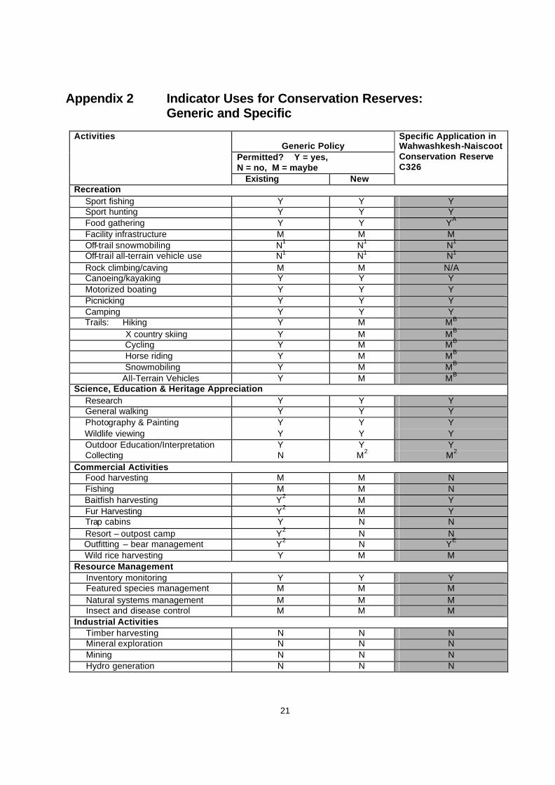
Appendix 2 Indicator Uses for Conservation Reserves: Generic and Specific
Generic Policy Permitted? Y = yes, N = no, M = maybe
Activities
Existing New
Specific Application in Wahwashkesh-Naiscoot Conservation Reserve C326
Recreation Sport fishing Y Y Y Sport hunting Y Y Y Food gathering Y Y YA
Facility infrastructure M M M Off-trail snowmobiling N1 N1 N1
Off-trail all-terrain vehicle use N1 N1 N1 Rock climbing/caving M M N/A Canoeing/kayaking Y Y Y Motorized boating Y Y Y Picnicking Y Y Y Camping Y Y Y Trails: Hiking Y M MB
X country skiing Y M MB Cycling Y M MB
Horse riding Y M MB
Snowmobiling Y M MB All-Terrain Vehicles Y M MB Science, Education & Heritage Appreciation Research Y Y Y General walking Y Y Y Photography & Painting Y Y Y Wildlife viewing Y Y Y Outdoor Education/Interpretation Y Y Y Collecting N M2 M2 Commercial Activities Food harvesting M M N Fishing M M N Baitfish harvesting Y2 M Y Fur Harvesting Y2 M Y Trap cabins Y N N
Resort – outpost camp Y2 N N Outfitting – bear management Y2 N YE Wild rice harvesting Y M M Resource Management
Inventory monitoring Y Y Y Featured species management M M M Natural systems management M M M Insect and disease control M M M
Industrial Activities Timber harvesting N N N Mineral exploration N N N Mining N N N Hydro generation N N N
22
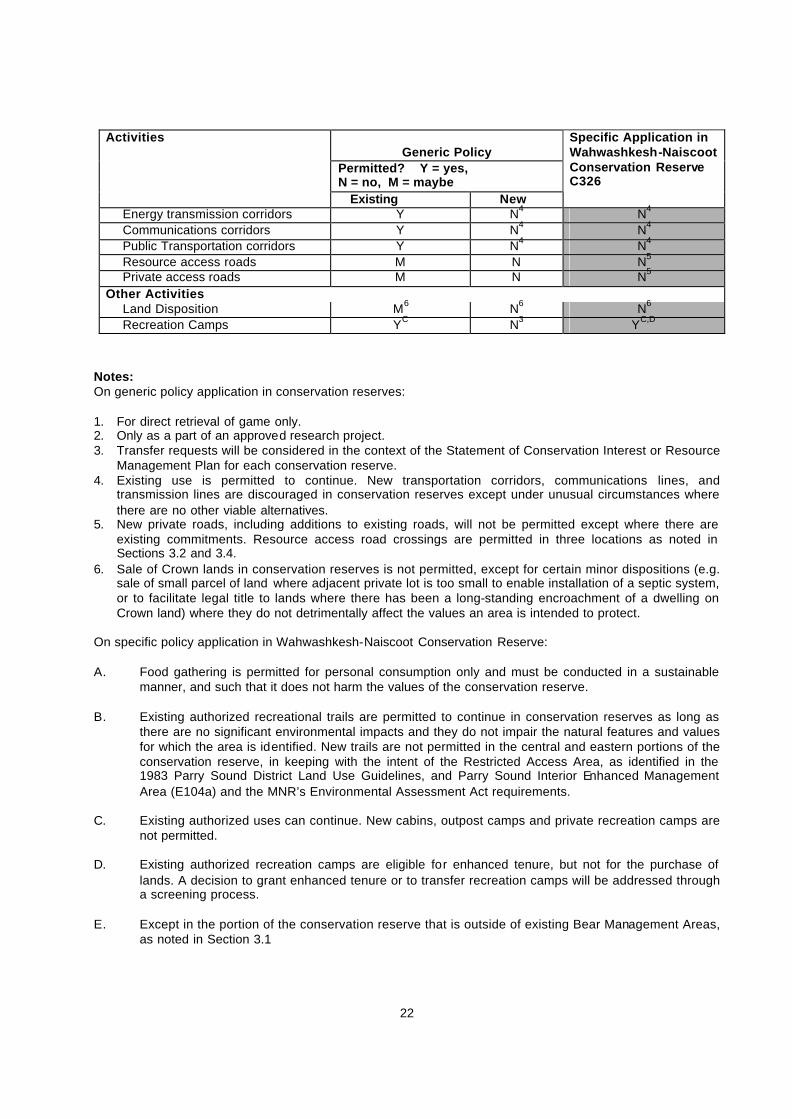
Generic Policy
Permitted? Y = yes, N = no, M = maybe
Activities
Existing New
Specific Application in Wahwashkesh-Naiscoot Conservation Reserve C326
Energy transmission corridors Y N4 N4 Communications corridors Y N4 N4 Public Transportation corridors Y N4 N4 Resource access roads M N N5 Private access roads M N N5
Other Activities Land Disposition M6 N6 N6 Recreation Camps YC N3 YC,D
Notes: On generic policy application in conservation reserves: 1. For direct retrieval of game only. 2. Only as a part of an approved research project. 3. Transfer requests will be considered in the context of the Statement of Conservation Interest or Resource
Management Plan for each conservation reserve. 4. Existing use is permitted to continue. New transportation corridors, communications lines, and
transmission lines are discouraged in conservation reserves except under unusual circumstances where there are no other viable alternatives.
5. New private roads, including additions to existing roads, will not be permitted except where there are existing commitments. Resource access road crossings are permitted in three locations as noted in Sections 3.2 and 3.4.
6. Sale of Crown lands in conservation reserves is not permitted, except for certain minor dispositions (e.g. sale of small parcel of land where adjacent private lot is too small to enable installation of a septic system, or to facilitate legal title to lands where there has been a long-standing encroachment of a dwelling on Crown land) where they do not detrimentally affect the values an area is intended to protect.
On specific policy application in Wahwashkesh-Naiscoot Conservation Reserve: A. Food gathering is permitted for personal consumption only and must be conducted in a sustainable
manner, and such that it does not harm the values of the conservation reserve. B. Existing authorized recreational trails are permitted to continue in conservation reserves as long as
there are no significant environmental impacts and they do not impair the natural features and values for which the area is identified. New trails are not permitted in the central and eastern portions of the conservation reserve, in keeping with the intent of the Restricted Access Area, as identified in the 1983 Parry Sound District Land Use Guidelines, and Parry Sound Interior Enhanced Management Area (E104a) and the MNR’s Environmental Assessment Act requirements.
C. Existing authorized uses can continue. New cabins, outpost camps and private recreation camps are
not permitted. D. Existing authorized recreation camps are eligible for enhanced tenure, but not for the purchase of
lands. A decision to grant enhanced tenure or to transfer recreation camps will be addressed through a screening process.
E. Except in the portion of the conservation reserve that is outside of existing Bear Management Areas,
as noted in Section 3.1
23
Appendix 3 Procedural Guideline C Research Activities in Conservation Reserves (PL Procedure 3.03.05) Purpose To encourage contributions to the goal of conservation reserves by: • Providing direction for research activities associated with conservation reserves; and • Establishing a process for the review and approval of proposals by researchers, which could have an
impact on the values protected by the conservation reserve. Definition Research means any investigation or study of the natural, cultural, economic, management or other features or characteristics of conservation reserves. Guidelines Research will be encouraged to provide a better understanding of the natural values protected by a conservation reserve and to advance their protection, planning and management. The Statement of Conservation Interest will define, for each conservation reserve, the key research issues, set out the parameters within which research may occur and identify research needs. Applications and Approvals Researchers must apply in writing to the Area Supervisor for permission to conduct research. The request letter must contain a statement explaining why the proposed research should be undertaken in the particular conservation reserve in preference to another location. Proposals will be reviewed and approved by the Area Supervisor, guided by the SCI prepared for each reserve (see Guideline A – Resource Management Planning) and using Guideline B – Land Uses – Test of Compatibility. Permission must be granted in writing, including any conditions to be met in conducting the research, prior to the undertaking of any research project. Term and Conditions Permission to conduct research under this policy will be valid for a period of 12 consecutive months from the date of issue. Permission to continue a research project for an additional periods of 12 months or less may be granted upon submission of a written request and a progress report. The Ministry may require the posting of collateral to assure that the terms and conditions of granting permission are met. The Area Supervisor may suspend or revoke permission at any time for failure on the part of the researcher to meet: 1. The intent of this policy. 2. The requirement s under the Public Lands Act, Ontario Regulation 805/94, including all amendments,
where applicable. 3. The requirements under any other Act or regulations of Ontario or Canada, including those governing
the taking, handling, storing, confining, fur harvesting, excavating and marketing any specimen, artefact, information or action (for example, scientific collector’s permit).
4. The conditions and agreements specified in granting permission. Final Report The researcher will submit copies of reports, publications and theses following the results of the project to the Area Supervisor.
24
Appendix 4 Recreation Camp Tenure Existing recreation camps within conservation reserves are generally permitted to continue. They may be eligible for “enhanced” tenure, but are not eligible for purchase of land. There are 2 forms of enhanced tenure that may be considered (as per September 22, 2000 direction from MNR’s Assistant Deputy Ministers of Natural Resource Management and of Field Services): • upgrade in the nature or type of tenure (e.g. from a Land Use Permit to a lease); and/ or • an extension in the term of the tenure (e.g. from 1 year to 10 years). Applications for enhanced tenure will be approved if determined acceptable using these screening criteria: i) Must follow the review process identified in MNR’s land disposition policies:
a) MNR District Manager must ensure that there will be no serious, foreseeable resource management or user conflicts as a result of the enhanced tenure;
b) The intended use/activity will not likely impact on Goal 1, 2 or 3 of the Provincial Policy Statement, issued under Section 3 of the Planning Act;
c) The site conforms with the MNR’s land use planning direction; d) The disposition is reviewed under the Environmental Assessment Act’s Exemption Order MNR 26/7; e) The site is not within a Provincial Significant Wetland (PSW). If the site is adjacent to a PSW it must
be determined that the proposed enhancement of tenure will not have a negative impact on the function or natural features of the wetland;
f) If the site is on lake trout lake, a lease will only be considered after such time as the policy on development on such lakes has been approved;
ii) Would not result in increased negative impact on natural heritage, cultural heritage or recreational values of the conservation reserve, or on existing authorized land uses;
iii) Must be subject to consultation with affected First Nations, and be consistent with any aboriginal land claim negotiations or protocol agreements;
iv) All rents, taxes, fees, rates or charges must be paid up.
A change in tenure does not convey a commitment to provide for, or agree to, a change in the type or the standard of existing access to the recreation camp.
��
���������
����� �
�����������
����
�����������
������� �!�"�#$�$
%&���"&'&��#$�$
�& ��()"& ���
��&'&�&�&�#$�$
'&�&)*� ���#$�$
%((���+��,��( �"�#$�$ '&�"&�%(�&'*��#$�$
+(* ��#$�$��������
�� ����������� �����
�������� ��
�����
����� ������ ���
��������
������
�� ��
��� ���� �� ����� ��!��
���"#�� ���
� ��� � ���$���� �$�
% #�� �� �������� #��
&�� ��� ��� ����'���(� "��
�������"����
�� ������������ �� �� �����
������������ ���������
�� ��� �����������$$����)����
�� ����� ����������������
� ������� �������
�����#"� ��
��� �� �
���"���������"�
&���������� ����������
���� � �������� ��#�� �����
*����+����� ) �"�
���� �������
���� &����� ����
�
�
�
�
������������ ������ �
������������� ������������������������������������������������������������ ���������������������������������������������������������������������������������������������������������������������� �������!��"##$���������������� ������"##$��%����&�'����������������
(����������������)������'����������������������*�+���������'����������������'",�-�$���� �������.*#!/�*$01$"#-
���������������
,
������-�2##�###
�������������� �
������������� �
��� ���������� �
����������� �
�� ��(,�����(-� ��� �
'�������(� �������(% ���
,������(�� �
� �������(�� �(.(����� ������(&��� ��
��34�����3���3�-#05�������5�� �� �
�������������� ����������!������"���#����"�$����#�
��������������
������������
��������
�
����������� ���������������
���������������������� ������ �!��"�!��"��#�����������$�%&�'�
()��������������������*���$&���������$����������+�,�����#����'�#�������������-���#���������������-���������,��'�����*�,����&
������
�������
������������������ �����
����������������������
�������������������
������������������������������ � � � !������������������������������������������"��#��$�����%����$��
&$$� ���'
(�'��%����$���$���
��#�')�*���������������#����������#����
� �����������"��*
��%����$���$���
���#��
����.��
!��"
/�)���)0�)�1�����#���!���*�����2��*
�34526��
���
�+��#�����������.�$�7-����%
������������� ������� ����������� ����������������
� � � � � � � � �
� � �� � � � �
�
�
� �
�
�� �
�� �
����
�
�
�
�
���
�
�
����� �
�
��� � ��� � �
�
�
�
���
���
� ���
��
���
���
�
�
�
� �
�
�
�
�
������
�
�
�� �
�
�����������
������ �������
��������
���������
���������
��������#*
+����'����#*
,���'� ����'' ���
,���'
�
����'' ���
����
��
���
��
� � � ��
��������
�����������
+��)
#���-
.
��������
���������
������������������
"&/ .
"&/���
"&/�.
"&/�0
"&/�1
"&/�-
"&/�-
$&��2
$&��3-
$&��3-$&��31
$&��3-
$&��31 $&��3�$&��30
$&��33
$&��3�
$&��32
$&��34
$&��3-
$&��31$&��3�
$&��30$&��33
$&��3.$&��3�
$&��32
$&��34
$&��3-
$&��31 $&��3�$&��30 $&��33
$&��3. $&��3�$&���� $&��32
$&��34
$&��3-
$&��31 $&��3�$&��30 $&��33
$&��3. $&��3�
$&����
$&����$&����
� � � � � � - 5�������'
����������������������������������� ��!"�������#���
�������
"��*'���'�
.���������
� (������$���
�� ��6�������''������
7�)�����8���������������9������������''��7��2�!
���%���������:;"��'��%��������'��%�
7�)�����8����������������7��.�!
��'�����������''���������"�3-���'�*����$(<='!
�
�������������
��������
�
����������� ���������������
���������������������� ������ �!��"�!��"��#�����������$�%&�'�
()��������������������*���$&���������$����������+�,�����#����'�#�������������-���#���������������-���������,��'�����*�,����&
������
�������
������������������ �����
����������������������
�������������������
������������������������������ � � � !������������������������������������������"��#��$�����%����$��
&$$� ���'
(�'��%����$���$���
��#�')�*���������������#����������#����
� �����������"��*
��%����$���$���
���#��
����.��
!��"
/�)���)0�)�1�����#���!���*�����2��*
�34526��
���
�+��#�����������.�$�7-����%
������������� ������� ����������� ����������������
��
��
��
��
��
��
��
��
��
��
��
��
��
��
��
��
��
� ��
��
��
��
��
��
��
��
��
��
��
��
��
��
��
��
��
��
�
�
�
��
�
�
�
����
� � �
��
�
�
��
��
��
�
�
�
�
�
�
�
� �� �
�
� ���
�����
�� ��
���������
��� ����
������
����� ���
��������
������������ ��
��������#*
+����'����#*
���
��
� � � �
� � � �
+����$�������
�����������
��������
"&,�-
"&,�.
"&,�/
"&,�0
"&,�1
$&��11$&���/$&��1-
$&��1�$&���2$&����
$&��10
$&���3$&���� $&��1/
$&���.$&���1
$&��12$&���-$&����
$&��13$&��0�$&���0
$&��1.$&���/
$&��1-$&���2
$&����$&���3 $&��10
$&����$&���.
$&��1/
$&�
$&���1$&���-
$&��12
$&��1�$&����$&��0�
$&��13
$&��1�
$&���0 $&��1.$&��11
$&��1-
$&��1�$&���2
$&����
$&��10$&���3
$&��1/$&���.
$&��12 $&��1�$&���-
$&����
$&��13 $&��1�$&��0�
$&���0
$&��1. $&��11
$&���/
$&��1- $&��1�
$&���2
$&���� $&��10
$&���� $&��1/$&���1 $&��12
$&���-
$&���� $&��1�$&���0 $&��1. $&��11
$&���/ $&��1- $&��1�$&���2 $&���� $&��10
$&���3 $&���� $&��1/$&���. $&���1 $&��12
$&���- $&����
$&��0� $&���0 $&��1. $&��11$&���/ $&��1- $&��1�
$&���2 $&���� $&��10$&���3 $&���� $&��1/
$&���. $&���1 $&��12$&���- $&���� $&��13
$&��0� $&���0 $&��1.$&���/ $&��1-
$&��1�$&���2 $&����$&��10$&���3 $&����
$&��1/$&���. $&���1$&��12$&���- $&����
$&��13$&��0� $&���0
$&��1.$&���/
$&��1-$&���2
4�'�����*����#*
� � � � � � 2 5�������'
����������������������������������� ��!"�������#���
�������
"��*'���'�
.���������
� (������$���
�� ��6�������''������
4�)�����7���������������8������������''��4��0�!
���%���������9:"��'��%��������'��%�
4�)�����7����������������4��-�!
��'�����������''���������"�12���'�*����$(;<'!
�������������
�
���������������

��������
�
����������� ���������������
���������������������� ������ �!��"�!��"��#�����������$�%&�'�
()��������������������*���$&���������$����������+�,�����#����'�#�������������-���#���������������-���������,��'�����*�,����&
������
�������
������������������ �����
����������������������
�������������������
������������������������������ � � � !������������������������������������������"��#��$�����%����$��
&$$� ���'
(�'��%����$���$���
��#�')�*���������������#����������#����
� �����������"��*
��%����$���$���
���#��
����.��
!��"
/�)���)0�)�1�����#���!���*�����2��*
�34526��
���
�+��#�����������.�$�7-����%
������������� ������� ����������� ����������������
��
��
��
��
��
�� �
��
��
��
��
��
��
�
� ��
��
�
����
�
�
�
�
��
��
��
�
�
�
�
��
�����
���
��
��
� �
�
��
���
�
���
�
������ ��� ��
��
�����
���
�
�
�
�����
���
���
����
�� ��
���
��
�
��
�
�
�
���
��
�
�
�
� ��
�
�
�����
�
���
�� �
�
�
��
�
� �� �
��
�
�
�
���������������
�������
����� �������
��� �������
����������
�����
���
���
� � � �
����������
�+���������
$���
�������������
�� ���
�����������
���������
����� ��������������
��������
�������
,�-��.����#*
��������#*
"&/�0
"&/�1
"&/�1
"&/�2
"&/�3
"&/�4
"&/��
$&����
$&��4$&���2
$&��3$&���1
$&��5$&���0$&��2
$&���3
$&����$&��6� $&���$&���4 $&��1
$&��6$&��6�$&���3 $&��0$&��66
$&���5
$&����
$&����$&��6� $&��4$&���2
$&��3$&���1
$&����
$&���$&���6
$&���0 $&����$&��6�
$&���4 $&���$&���3
$&��1$&��6� $&��6$&���3 $&��0$&��66
$&���5
$&����
$&��6�$&���2
$&����$&��64
$&���1
$&���6
$&��5$&��63$&���0
$&����
$&��2 $&� �$&��6� $&���
$&���4$&��1
$&��6� $&��6
$&���3
$&��0$&���$&��66
$&���5
$&���� $&��4$&��6�$&���� $&��3
$&��64
$&���6 $&��5$&��63
$&���� $&��2$&��65 $&�$&���4 $&��1
$&��6$&���3 $&��0$&���
$&���5
$&����$&��4
$&���2 $&���� $&��3$&��64 $&���1 $&���6 $&��5
$&��63
$&���0
$&���� $&��2
$&��65
$&��6�$&���4 $&��1
$&��62
$&��6� $&� 6$&���3 $&��0$&���$&��66 $&���5 $&����
$&��4$&��6� $&���2 $&����$&��3$&��64 $&���1 $&���6
$&��5$&��63 $&���0 $&���� $&��2$&��65 $&��6� $&���4 $&��1
$&��62 $&��6� $&���3 $&��0$&��61 $&��66 $&� �$&���5 $&����
$&��4$&��6� $&���2 $&����$&��3$&��64 $&���1 $&���6
$&��5$&��63 $&���0 $&����$&��2$&��65 $&��6� $&���4
$&��1$&��6�
� � � � � � 5 -�������'
����������������������������������� ��!"�������#���
�������
"��*'���'�
.���������
� (������$���
�� ��+�������''������
7�)�����,���������������8������������''��7��4�!
���%���������9:"��'��%��������'��%�
7�)�����,����������������7��0�!
��'�����������''���������"�65���'�*����$(;<'!
�������� ���������
�