Embed Size (px)
Citation preview

171
WAIPU RIVER ESTUARY AND SANDSPIT
Survey no. Q08/228
Survey date 13 November 2006
Grid reference Q08 447762
Area 220.5 ha (73.9 ha duneland, 144.6 ha estuary, 2.1 ha forest)
Altitude 0–10 m asl
172
Ecological units
(a) Mudflat and sandflat in estuary (40%)
(b) Sandfield habitat on beach and sand dune (20%)
(c) Estuarine open water (15%)
(d) Spinifex grassland on sand dune (7%)
(e) Purple groundsel–South African iceplant herbfield on sand dune (2%)
(f) Sea rush rushland in estuary (2%)
(g) Sea rush–Austrostipa stipoides rushland in estuary (1%)
(h) Oioi rushland in estuary (1%)
(i) Knobby clubrush–tall fescue sedgeland in estuary (1%)
(j) Mangrove shrubland and forest in estuary (1%)
(k) Saltwater paspalum grassland in estuary (1%)
(l) Sea primrose–remuremu herbfield in estuary (1%)
(m) Seagrass grassland in estuary (1%)
(n) Marsh clubrush sedgeland in brackish seepage (1%)
(o) Buffalo grass–South African iceplant grassland on sand dune (1%)
(p) Buffalo grass–pohuehue–knobby clubrush shrubland on sand dune (1%)
(q) South African iceplant–harestail–shore bindweed herbfield on sand dune (1%)
(r) Pingao sedgeland on sand dune (1%)
(s) Carex pumila sandfield on beach (1%)
(t) Pohutukawa treeland on steep hillslope and cliff (1%)
Landform/geology
Holocene dune barrier, and estuarine sandy intertidal flats and channels to landward,
with a low ridge of Pleistocene consolidated dune sand on the western side of the
estuary between Q08 453747 and Q08 458742.
Vegetation
This site comprises a stretch of approximately 5 km of estuarine mudflats, sandflats,
open water, and saltmarsh vegetation enclosed by an approximately 5 km long
sandspit. The site extends from the southernmost point of the sandy beach at Waipu
Cove up to the northern boundary of the river mouth,* and follows the waterway
inland to about 0.5 km. There is little vegetation within the main river channel, the
majority of it being in the southern area of the estuary. The sandspit is entirely wild
habitat except for its extreme southern end where the natural dune vegetation is
restricted to the front 1–20 m of the dune (the rest of the dunes here are now a
campground within the Waipu Cove Domain Recreation Reserve). Where natural
dune vegetation has been removed entirely there is kikuyu grassland (which is not
included in this site). On the landward side, the estuary is bordered mainly by flat
pastoral land and residential dwellings, with a consolidated dune sand ridge with
pohutukawa treeland (t) that stretches along part of the southern margin. Although
residential development restricts it to a very narrow strip, the pohutukawa treeland
has a diverse range of indigenous understorey species, including kawakawa, karaka,
karo, hangehange, Coprosma macrocarpa, mamaku, houpara, and harakeke.
* The northern side of Waipu Government Purpose Wildlife Refuge is included within site Q07/128.

173
174
This site includes the most extensive intertidal mudflats and sandflats (a) in Waipu
Ecological District. Complementary to these are large areas of mobile beach and dune
sands (b) and meandering estuarine channels and pools with open water (c), all of
which provide important habitat for birds and marine invertebrates (see below). The
only sea grass beds (m) within Waipu ED occur in this site, distributed in several
patches along the southern side of the main channel of the southern area of the
estuary.
Saltmarsh vegetation increases in stature with distance from the estuary mouth. At
Johnson Point Road (inside the rock wall, near the mouth), there are low mats of sea
primrose–remuremu herbfield (l), Carex pumila sandfield (s) and saltwater
paspalum grassland (k) covering parts of the intertidal mudflats. Where freshwater
seepages join the estuary there are narrow strips of marsh clubrush sedgeland (n).
Moving further into the estuary there are large contiguous areas of sea rush
tussockland (f) and sea rush–Austrostipa stipoides tussockland (g) on the inner
sandspit margin. In the upper reaches there is a small grove of mangrove shrubland
and forest (j) in a mosaic with oioi rushland (h), mudflats with mangrove seedlings,
and knobby clubrush–tall fescue sedgeland (i). Harakeke and saltmarsh ribbonwood
are dotted around the edges, along with occasional native celery.
The vegetation cover also varies considerably along the length of the sandspit. At its
base there are heavily exotic communities such as buffalo grass–South African
iceplant grassland (o) and buffalo grass–pohuehue–knobby clubrush shrubland (p),
which adjoin the campground. Purple groundsel, sand wind grass and spinifex are all
frequent within these two types, and there are occasional catsear, harakeke, lupin,
shore bindweed, Oxalis rubens, ripgut brome, pohuehue, and knobby clubrush.
Akeake, taupata, karo, pohutukawa, harakeke, pingao and two plants of
Austrofestuca littoralis appear to have been planted in this dune vegetation. Also,
recent planting of pingao, spinifex, Carex testacea and Libertia sp. has been carried
out on bare areas of the foredune where buildings are very close to the beach. At the
southern end of the Wildlife Refuge, behind the crest of the dune, there is South
African iceplant–harestail–shore bindweed herbfield (q) which appears to have been
burnt or sprayed recently, perhaps to control the iceplant. Spinifex grassland (d)
clothes most of the foredune from base to tip, but towards the tip its density increases
and its associated species change. At the base it is associated with frequent harestail
and buffalo grass, but moving northwards these species decrease in abundance and
purple groundsel becomes frequent. The most common vegetation type at the back
of the foredune in middle to northern areas of the spit is a distinctly purple-coloured
herbfield with abundant purple groundsel and common South African iceplant (e).
There are several large patches of pingao sedgeland (r) sprawling over the seaward
slope of the foredune. Marram was recorded on the sandspit in 1991 (SSBI Q08/
H018), but was not noted during this rapid survey.
Significant flora
Pingao (Gradual Decline) and Coprosma acerosa (regionally significant) were
recorded in 1991 (SSBI Q08/H018). Triglochin striata (regionally significant) was
recorded in 2006 (Wilcox 2006).
Fauna
NZ fairy tern (Nationally Critical), Caspian tern (Nationally Vulnerable), wrybill
(Nationally Vulnerable), northern NZ dotterel (Nationally Vulnerable), reef heron
(Nationally Vulnerable), banded dotterel (Gradual Decline), white-fronted tern

175
(Gradual Decline), red-billed gull (Gradual Decline), black shag (Sparse), pied shag,
little shag, bar-tailed godwit (Migrant), lesser knot (Migrant), turnstone (Migrant),
red-necked stint (Migrant), white-faced heron, royal spoonbill, pied oystercatcher,
variable oystercatcher (regionally significant), pied stilt, Australasian harrier, black-
backed gull, NZ kingfisher, welcome swallow, spur-winged plover, paradise shelduck
and little tern have all been recorded recently in the area (Katrina Hansen pers. comm.
2005 – SSBI Q08/H018). Eastern curlew (Migrant), Pacific golden plover (Migrant),
Arctic skua (Migrant), Pomarine skua (Migrant), sharp-tailed sandpiper (Migrant),
and possibly Hudsonian godwit (Migrant) are occasional visitors (Katrina Hansen
pers. comm. 2005). Small groups of little black shag (Range Restricted) are often
seen feeding on the Waipu River (Ray Pierce pers. comm.).
A terek sandpiper (Migrant) was seen here in 2005 (John Kendrick pers. comm.
2006). Whimbrels (Migrant) have been recorded once in the 1990s (Ray Pierce pers.
comm.). A pectoral sandpiper was seen in 1992 (CSN Notornis 41). Two curlew
sandpipers (Migrant) were seen in 1994 (CSN Notornis 43). A western sandpiper
was recorded in 1999 (CSN Notornis 47). A greenshank (Vagrant) was observed in
2001 (Richard Parrish pers. comm.). A little tern (Migrant) was observed in 2001
(CSN Notornis 49). Individual banded rails (Sparse) were recorded only twice in the
last 15 years, in 1992 (CSN Notornis 41) and 1999 (CSN Notornis 47). There are
anecdotal records of northern little blue penguin (Gradual Decline) on the beach at
Waipu Cove in the 1990s (Ray Pierce pers. comm.), but not since. Occasional solitary
white herons (Nationally Critical) have been recorded in 1990 (CSN Notornis 39),
1993 (CSN Notornis 41) and 1995 (Burtt et al. 1995). Australasian shoveler
(regionally significant) was recorded in 1977, and grey duck (Nationally Endangered)
was recorded in 1977 and again in 1991 (SSBI Q08/H018). NZ pipit was observed on
the sandspit in the 1980s (Richard Parrish pers. comm.). NZ shore plover (Nationally
Critical) have appeared in this site twice in the late 1990s following their release on
Motuora Island, near Warkworth (Richard Parrish pers. comm.). A southern elephant
seal (Nationally Critical) was present at Waipu Cove in January 1996 during the
National Beach Volleyball Championship (Richard Parrish pers. comm.).
NZ fairy tern, northern NZ dotterel, and variable oystercatcher are the main shorebird
species which nest here, their breeding sites being concentrated around the end of the
spit (Hansen 2005). White-fronted terns breed here occasionally (Katrina Hansen and
Richard Parrish in CSN Notornis 50). This is the only breeding site for NZ fairy tern in
Waipu ED, and one of only four breeding sites for the species nationwide (three pairs
at Waipu, four pairs at Mangawhai, two pairs at Papakanui, and one pair at Pakiri in
2005–2006 season). NZ fairy tern has a population of approximately 35 adult
individuals, plus seven chicks (including three from Waipu) fledged in the 2005–2006
season (Williams 2006). This site is considered to be a ‘key breeding site’ for northern
NZ dotterel, with 14–16 pairs recorded in recent times (Dowding and Moore 2006).
There has been a shorebird protection programme on the spit since 1997/1998, with
seasonal rangers who erect temporary fencing, trap rats, cats, mustelids, and
hedgehogs and carry out advocacy (Hansen 2005).
Dead and live yellow-bellied sea snakes have washed up at Waipu Cove in 1931 and
1965 (DOC Bioweb 2007). Shore skinks were found to be quite common on the
sandspit in 1999 (16 individuals found in 1 hour) (DOC Bioweb 2007).
Significance
This site has the largest river estuary in Waipu ED, and the second largest area of
duneland habitats in Waipu ED. Within the ED the sandspit is unique; it is the only

176
relatively isolated stretch of duneland that is not bordered by housing or other
development, and is entirely legally protected for the purpose of wildlife
conservation. The spit is a nationally important breeding site for the most threatened
bird species in New Zealand, the NZ fairy tern. A further eleven threatened bird
species (Caspian tern, wrybill, northern NZ dotterel, reef heron, banded dotterel,
white-fronted tern, red-billed gull, black shag, grey duck, white heron, and little black
shag) and one regionally significant bird species (variable oystercatcher) are present,
as well as a high diversity (and often very high numbers) of international migrant
waders (including bar-tailed godwit, lesser knot, turnstone, and red-necked stint).
Nesting and feeding shorebirds are threatened by predation, storm-related events,
quad bikes, jet-skiers, and other inconsiderate recreational use. Large numbers of
people visit and dwell near this important area. This site is quite different to the other
duneland site in Waipu ED (Ruakaka Dunelands Q07/128), and most of the ecological
units are considered representative (15 of 20): (a) mudflat and sandflat in estuary, (b)
sandfield habitat on beach and sand dune, (c) estuarine open water, (d) spinifex
grassland on sand dune, (f) sea rush rushland in estuary, (g) sea rush–Austrostipa
stipoides rushland in estuary, (h) oioi rushland in estuary, (j) mangrove shrubland
and forest in estuary, (i) knobby clubrush–tall fescue sedgeland in estuary, (l) sea
primrose–remuremu herbfield in estuary, (m) seagrass grassland in estuary,
(r) pingao sedgeland on sand dune, (s) Carex pumila sandfield on beach, and (t)
pohutukawa treeland on steep hillslope and cliff. 69% (152 ha) of this site is formally
protected, as follows: 115.9 ha in Waipu Government Purpose Wildlife Refuge (DOC-
administered), 30.3 ha in Waipu Wildlife Refuge (DOC-administered), 3.3 ha in
Waipu Cove Domain Recreation Reserve (DOC-administered), 0.3 ha in Waipu River
Marginal Strip (DOC-administered) and 2.2 ha in a WDC-administered esplanade
reserve.
LANG’S BEACH
Survey no. Q08/230
Survey date 14 November 2006
Grid reference Q08 491716
Area 7.9 ha (7.9 ha duneland)
Altitude 0–20 m asl
Ecological units
(a) Sandfield habitat on beach (95%)
(b) Harestail–spinifex grassland on sand dune (1%)
(c) Carex pumila sandfield on beach (1%)
(d) Marsh clubrush sedgeland in brackish seepage (1%)
(e) Pingao sedgeland on sand dune (1%)
(f) Sickle grass grassland on sand dune (1%)
Landform/geology
Holocene beach sands.
Vegetation
This site comprises a 1.8 km sandy beach enclosed by rocky headlands, including a
small sand dune at the outflow of an unnamed stream into McKenzie Cove. Residential
areas, exotic grassland and scattered trees (including pohutukawa) border the beach,

177
and at either end there are forested headlands. Lang’s Beach Coastal Forest and
Shrubland (Q08/226) nearby provide a broken ecological sequence through to the
Brynderwyn Hills Forest Complex (Q08/225).
The majority of this site is fine beach sand (a), which is a bird roost and also a popular
recreational area. Occasional sea rocket (Cakile maritima) are scattered along the
strand line. The small sand dune is vegetated with pingao sedgeland (e) (possibly
planted). The main vegetation type on the dune is harestail–spinifex grassland (b)

178
which has a high diversity of associated species including frequent catsear, vulpia hair
grass, King Island melilot, and shore bindweed, and occasional pingao, ripgut brome,
allseed, catchfly, bur medick, milkweed, hawkbit, South African iceplant, hairy
birdsfoot trefoil, sand wind grass, prairie brome, buffalo grass, large quaking grass,
white clover, puha, purple-top, veldt grass, Yorkshire fog, cleavers, periwinkle,
annual poa, Agave sp., tall fescue, rye grass, dock, and fathen. Around the stream
outflow there are very small areas of Carex pumila sandfield (c), marsh clubrush
sedgeland (d), and sickle grass grassland (f).
Significant flora
Pingao (Gradual Decline).
Fauna
Red-billed gulls (Gradual Decline) were observed roosting on the beach in the current
survey. There are anecdotal records of northern blue penguin (Gradual Decline)
coming up onto Lang’s Beach, but they probably do not breed here (Ray Pierce pers.
comm.).
Significance
Lang’s Beach is a small, naturally formed sandy beach with high recreational use,
bordered by residential housing and amenity areas. Aside from its obvious
recreational and aesthetic values, it is also ecologically significant as a bird roost,
including two threatened species (red-billed gull and northern blue penguin). One
small dune within the site supports a threatened plant species (pingao), though this
may be planted. In general the dune and strand vegetation is relatively degraded, with
a high proportion of exotic species. The beach is loosely connected with forest
remnants within the catchment (Q08/226), which include some overhanging
pohutukawa forest on cliffs.
WAIHOIHOI RIVER FOREST REMNANTS
Survey no. Q08/231
Survey date 15 November 2006
Grid reference Q08 396773 (2 remnants)
Area 19.3 ha
Altitude 10–40 m asl
Ecological units
(a) Totara–taraire forest on alluvium (70%)
(b) Taraire forest on alluvium (20%)
(c) Totara–kahikatea forest on moderate hillslope (10%)
Landform/geology
Stream channels containing Holocene alluvium, cut into Late Pleistocene (last
interglacial) constructional terrace on alluvial and/or estuarine deposits, and
hillslopes underlain by Miocene sandy mudstone (Waitemata Group).
Vegetation
This site comprises two remnants of riparian forest in the Waihoihoi River catchment.
The remnants, whilst narrow, follow the course of the river for approximately 2 km.
A small area that has been fenced has an understorey of karaka seedlings and
tradescantia. The surrounding land use is pastoral farming except for where the

179
largest Braigh Forest remnant (Q08/229) adjoins the western edge of the southern
remnant. The remnants are approximately 2 km to the east of the extensive Mareretu
and Ahuroa Road forest areas.

180
(a) In the majority of the remnants totara and taraire are common, and there are
occasional kowhai, manatu, ti kouka, kanuka, karaka, mahoe, mapou, ponga, and
tarata. Chinese privet is occasional along the forest edge.
(b) One part of the remnant is taraire forest with frequent rewarewa and kahikatea
and occasional puriri, kowhai, and kohekohe.
(c) Where an east-facing hillslope abuts the central part of the remnants the forest is
dominated by totara and taraire and rewarewa and karaka are occasional.
Significant flora
Manatu (regionally significant).
Fauna
North Island fantail and NZ kingfisher recorded in this survey.
Significance
The site is representative for two ecological units: (a) totara–taraire forest on
alluvium, which was found nowhere else in Waipu ED, and (b) taraire forest on
alluvium. The canopy is diverse and healthy, but most of the site is grazed with a
sparse understorey and there are localised infestations of tradescantia and Chinese
privet. The remnants, which are narrow in shape, provide riparian protection for the
lower Waihoihoi River. One regionally significant plant species is present (manatu).
WAIONEHU STREAM FOREST REMNANTS
Survey no. Q08/232
Survey date 15 November 2006
Grid reference Q08 419768 (17 remnants)
Area 19.7 ha
Altitude 10–30 m asl
Ecological units
(a) Totara treeland on alluvium (65%)
(b) Totara–kanuka forest on alluvium (20%)
(c) Totara–puriri–kanuka forest on gentle hillslope (15%)
Landform/geology
Stream channels containing Holocene alluvium, cut into Late Pleistocene (last
interglacial) constructional terrace on alluvial and/or estuarine deposits, and
hillslopes underlain by melange of undifferentiated Mangakahia and Motatau
Complex lithologies; northern outlier on Late Pleistocene (last interglacial)
constructional terrace on alluvial and/or estuarine deposits.
Vegetation
This site comprises a series of narrow riparian forest and treeland remnants
distributed along the alluvial flats of the Waionehu Stream. The remnants are set
within a landscape of intense pastoral agriculture, and none appear to be fenced. The
main vegetation type is totara treeland (a) with frequent crack willow and occasional
kanuka, ti kouka, kahikatea, mapou, coral tree, mamaku, titoki and pigeonwood.
Severe weed impacts are evident in the understorey, which is smothered by
tradescantia and also has infestations of cotoneaster, garden nasturtium, Calystegia
sylvatica, arum lily and Jerusalem cherry. Indigenous understorey species include
Muehlenbeckia australis, mapou, mahoe, Haloragis erecta, leather-leaf fern,

181
hangehange, and Coprosma rigida, which is regionally significant. Other vegetation
types present are totara–kanuka forest (b) which is located at the northern end of the
site, in the vicinity of Waipu township. This remnant has frequent Chinese privet and

182
occasional kauri and gorse. A gentle hillslope adjoining one of the alluvial flats
supports totara–puriri–kanuka forest (c) with occasional karaka, rewarewa, and
poplar.
Significant flora
Coprosma rigida (regionally significant) was recorded in this survey (AK 297990).
Fauna
Shining cuckoo, NZ kingfisher, grey warbler, and North Island fantail.
Significance
This site contains small examples of uncommon habitat types (forest on alluvium)
however they are not considered representative due to small size and general
degradation. Nonetheless, these are the only remaining vegetation remnants along the
lower Waionehu Stream, and they provide riparian protection as well as probably
acting as a wildlife corridor between the Brynderwyn Hills and the Waipu River
estuary. There is one regionally significant plants species present (Coprosma rigida),
however the majority of the site is so heavily weed infested that its natural character is
under threat of disappearing.
STATE HIGHWAY 1 FOREST REMNANTS
Survey no. Q08/233
Survey date 15 November 2006
Grid reference Q08 390782 (8 remnants)
Area 7.4 ha
Altitude 10–11 m asl
Ecological units
(a) Kanuka–kahikatea forest on alluvium (50%)
(b) Kahikatea forest on alluvium (45%)
(c) Kahikatea–puriri–ryegrass–creeping buttercup treeland on alluvium (5%)
Landform/geology
Terrace on Late Pleistocene (last interglacial) alluvial and/or estuarine deposits.
Vegetation
This site comprises eight small forest remnants on the alluvial plain formed by the
Ahuroa and Waihoihoi Rivers. The remnants are in two groups, with two in the south
to the west of SH1 and six in the north near the SH1 turnoff to Waipu. The remnants
are grouped as one site due to the similarity of their vegetation and landform; the
eight remnants were presumably part of the extensive forests that formerly covered
this alluvial plain. The surrounding land use is pastoral farming, roads and residential
gardens. The southernmost remnant is adjacent to a garden and is severely infested
with weeds including tuber ladder fern, Madeira vine, Japanese spindle tree, jasmine,
arum lily, tradescantia, monkey apple, Chinese privet, and velvet groundsel. Native
species in the understorey included ponga, pigeonwood, mapou, nikau, kohekohe,
mahoe, kohuhu, and karaka. All of the remnants are within c . 1 km of the extensive
Mareretu and Ahuroa Road forest remnants.
(a) In the two southern remnants kanuka is abundant, kahikatea is common, and
totara is frequent. The smaller and southernmost remnant is fenced to exclude stock
and has kahikatea trees up to 70 cm diameter.

183
(b) In the six northern remnants kahikatea is abundant, totara is frequent, and kauri,
rimu and puriri are occasional. Chinese privet is common or abundant in the
understorey.

184
(c) On the southern edge of one of the northern remnants is an area of kahikatea–
puriri treeland. Chinese privet is frequent and occasional species include pukatea,
karamu, tree privet, ti kouka, rewarewa and kahakaha. The grazed pasture under the
trees is perennial ryegrass and creeping buttercup with frequent wild carrot.
Significant flora
Coprosma rigida (regionally significant) occurs in the understorey of the
southernmost remnant (AK 298333).
Fauna
North Island fantail and NZ kingfisher recorded in this survey.
Significance
This site is representative for the ecological unit (a) kanuka–kahikatea forest on
alluvium. This ecological unit was not found elsewhere in Waipu ED and covers
approximately 3.7 ha. The remnants have a healthy canopy, but are mostly grazed
with severe weed infestations. One regionally significant plant species (Coprosma
rigida) occurs in the understorey of the southernmost remnant.
AHUROA RIVER FOREST REMNANTS
Survey no. Q08/235
Survey date 12 November 2006
Grid reference Q08 379766 (18 remnants)
Area 53.8 ha
Altitude 10–60 m asl
Ecological units
(a) Totara forest on alluvium (88%)
(b) Kahikatea–totara forest on alluvium (10%)
(c) Taraire forest on alluvium (2%)
Landform/geology
Stream channels containing Holocene alluvium, cut into Late Pleistocene (last
interglacial) constructional terrace on alluvial and/or estuarine deposits.
Vegetation
This site comprises riparian forest remnants in the Ahuroa River catchment between
Durham Road and Millbrook Road. The southern remnants are grazed with little or no
understorey, the largest central remnant has an area from which stock are excluded
adjacent to Brooks Road, and the northernmost remnants are grazed. Tradescantia is
common throughout.
(a) The majority of the site, including the largest central remnant, has abundant totara
with occasional taraire, kanuka, kahikatea, manatu, kowhai, ti kouka, titoki, karaka,
and crack willow.
(b) In the northernmost remnants, adjacent to Ahuroa Road, kahikatea and totara are
common, and titoki, puriri, taraire, kowhai, manatu, matai, mamangi, pohuehue and
turepo are occasional. In the vicinity of the water pumping station at the end of
Ahuroa Road, the remnant is only lightly grazed and mature taraire and manatu are
locally abundant.

185

186
(c) The small, southeasternmost remnant is mature taraire forest with occasional
titoki, kahikatea, totara, rewarewa, and kahakaha.
Significant flora
Manatu (regionally significant).
Fauna
North Island fantail, kukupa (Gradual Decline), NZ kingfisher, paradise shelduck,
shining cuckoo were recorded in this survey. Cran’s bully, common bully and an
unidentified eel species were recorded in 1999 (NIWA 2007).
Significance
This site is representative for the ecological units: (a) totara forest on alluvium, and
(b) kahikatea–totara forest on alluvium; this site contains the largest areas of each of
these ecological units in Waipu ED. Most of the remnants are grazed with a sparse
understorey, and there are localised weed infestations of crack willow and
tradescantia. One regionally significant plant species (manatu) and one threatened
bird species (kukupa) are present. The remnants provide riparian protection for the
Ahuroa River, and provide linkages between remnants in the upper and lower Ahuroa
River catchment. 1.0 ha of this site is within an esplanade reserve (WDC-
administered).
DODD ROAD FOREST REMNANT
Survey no. Q08/236
Survey date 12 November 2006
Grid reference Q08 330702
Area 4.5 ha
Altitude 80–160 m asl
Ecological units
(a) Taraire forest on moderate hillslope (80%)
(b) Tanekaha–rewarewa forest on steep hillslope (20%)
Landform/geology
Hillslope underlain by Miocene sandstone and mudstone (Waitemata Group).
Vegetation
This forest remnant is on a moderate to steeply sloping, south-facing hillslope in the
headwaters of the Waikopikopiko Stream. The western end of the remnant adjoins
radiata pine forest, and the remaining three sides are surrounded by pasture. The
canopy is in good health but cattle have access throughout and the understorey is
likely to be sparse. No mature, emergent podocarps or kauri are present.
(a) The majority of the remnant is taraire forest with frequent rewarewa, kahikatea,
and nikau. Totara, tawa, ponga, mamaku, ti kouka, mahoe, pukatea, rimu, and puka
are occasional.
(b) On the steep, upper hillslopes of the eastern half of the remnant, tanekaha is
abundant, rewarewa is common, kanuka is frequent, and ti kouka, kauri, kohuhu, and
mamaku are occasional.
Fauna
Not surveyed.

187
Significance
This site is representative for the ecological unit (b) tanekaha–rewarewa forest on
steep hillslope, which is found at only two locations in Waipu ED. The remnant has a
diverse canopy, is of compact shape, and extends from a ridge to a gully. Cattle have

188
access to the remnant and the understorey is likely to be sparse. The remnant adjoins
plantation forests on its northwestern side.
DURHAM ROAD FOREST AND SHRUBLAND
Survey no. Q08/237
Survey date 12 November 2006
Grid reference Q08 369723 (11 remnants)
Area 41.7 ha (40.2 ha forest, 1.5 ha shrubland)
Altitude 40–140 m asl
Ecological units
(a) Rimu–kanuka forest on moderate hillslope (60%)
(b) Kanuka forest on moderate hillslope (30%)
(c) Taraire forest on moderate hillslope (5%)
(d) Kanuka–manuka shrubland on moderate hillslope (5%)
Landform/geology
Hillslopes and gullies underlain by Mesozoic greywacke (Waipapa Terrane) and
Miocene sandstone and mudstone (Waitemata Group).
Vegetation
This site comprises forest and shrubland remnants on the north facing slopes
adjacent to Durham Road. All of the remnants are in close proximity to the northern
edge of Waipu Gorge.
(a) The two largest remnants on the eastern side and the westernmost remnant are
fenced to exclude stock, and have a canopy dominated by rimu and kanuka, with
occasional manuka, mamangi, mahoe, mapou, tanekaha, kauri, totara and nikau. In
the two largest eastern remnants the understorey is well established and includes
kiokio, mapou, ponga, pate, kohuhu, turutu, karamu, tanekaha, hangehange, and
mida. In the westernmost remnant, the understorey is dominated by mahoe and pate.
(b) The central remnants mostly comprise kanuka forest. Kahikatea is frequent, with
occasional rimu, kauri, rewarewa, and totara. These remnants are probably grazed.
(c) The remnant at Q08 362718 (on the western side of the site) is mature taraire
forest with frequent rewarewa and nikau, and occasional puka, rimu, karaka, mahoe,
kanuka, and pate.
(d) On the upper slopes of the central remnants are two areas of kanuka–manuka
shrubland. Mamaku is frequent, with occasional kahikatea, pigeonwood, mapou,
nikau, karaka, ponga, ti kouka, and gorse. The shrubland areas are grazed.
Significant flora
Mida (Gradual Decline) was found in the understorey of the easternmost remnant
during this survey.
Fauna
North Island fantail, NZ kingfisher, and shining cuckoo were recorded in this present
survey.
Significance
These remnants have a diverse, healthy canopy, and areas that are fenced have an
established understorey. The site is representative for (a) rimu–kanuka forest on

189
moderate hillslope; this ecological unit is not found elsewhere in Waipu ED and covers
approximately 25 ha. The remnants form northerly extensions to the extensive
Waipu Gorge Forest Remnants (Q08/222), and provide linkages between the Waipu
Gorge and other forest remnants in the vicinity of Brooks Road. The site is habitat for
one threatened plant species (mida).

190
MAXWELL CREEK FOREST REMNANT
Survey no. Q08/238
Survey date Not surveyed
Grid reference Q08 346717
Area 31.5 ha
Altitude 140–207 m asl

191
Ecological unit(s)
(a) Mamaku forest on moderate hillslope and in gully (100%)
Landform/geology
Hillslopes and gullies underlain by Miocene sandstone and mudstone (Waitemata
Group).
Vegetation
This remnant is in gullies in the headwaters of Maxwell Creek. The intervening ridges
are radiata pine forest, the western edge of the remnant is bordered by pasture, and
the eastern edges are contiguous with the extensive Waipu Gorge Forest Remnants
(Q08/222). Due to lack of site access and visibility, the vegetation cover was
estimated from recent aerial photography (January 2004) to be mamaku–kanuka
forest (a). Whilst probably entirely secondary, the remnant was included because of
its proximity or linkages to other remnants, and because of its significant size.
Fauna
Longfin eel (Gradual Decline), and shortfin eel were recorded in 2003 (NIWA 2007).
Significance
Interpretation of 2004 aerial photography indicates that this site supports a similar
forest type to that present in Brooks Road Forest and Shrubland (Q08/221),
immediately to the north, but this could not be confirmed during the current survey
due to lack of site access and visibility. The dominance of mamaku reflects its
disturbance by forestry operations, and the western edges of the remnant are
probably grazed. However, the site is contiguous with Waipu Gorge, and provides
riparian protection for Maxwell Creek that flows into Waipu Gorge and the Ahuroa
River. Maxwell Creek is habitat for one threatened fauna species (longfin eel).
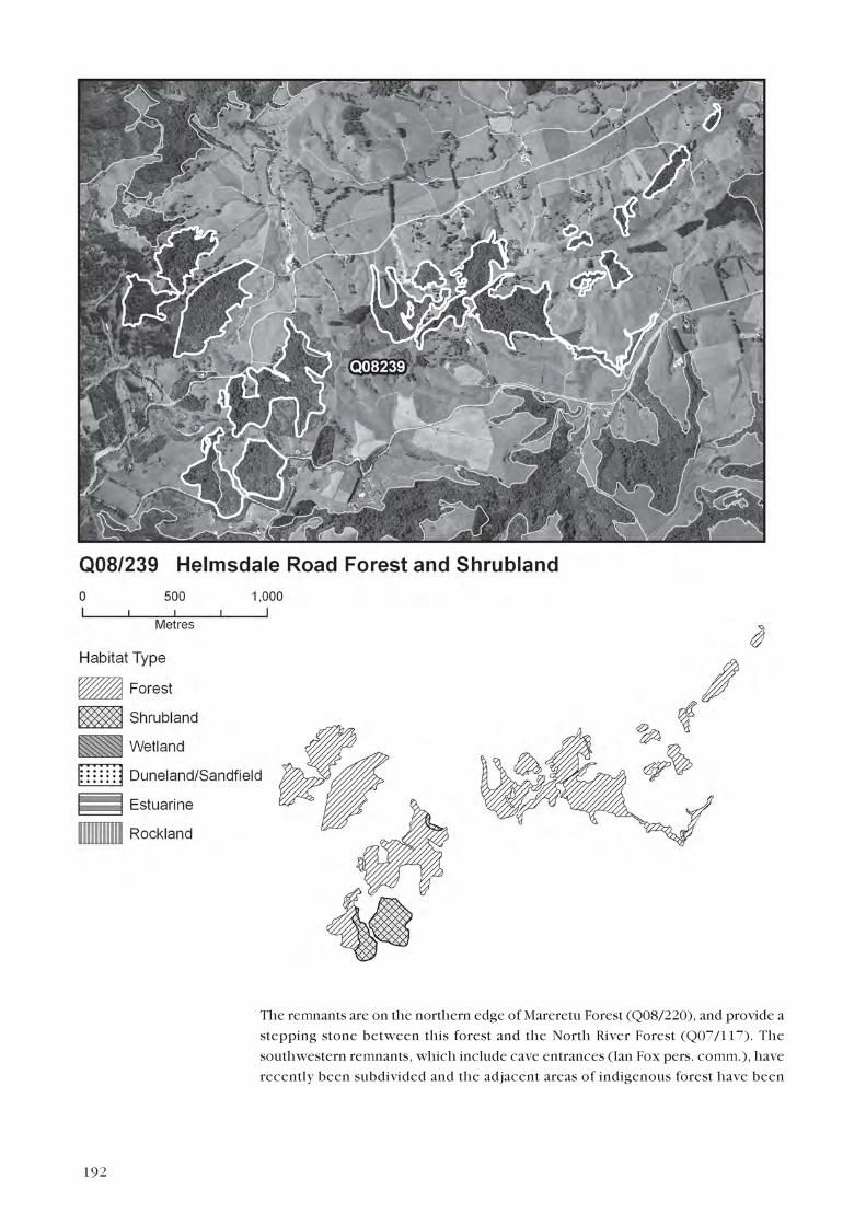
HELMSDALE ROAD FOREST AND SHRUBLAND
Survey no. Q08/239
Survey date 14 November 2006
Grid reference Q08 333801 (21 remnants)
Area 85.2 ha (75.8 ha forest, 9.5 ha shrubland)
Altitude 40–151 m asl
Ecological units
(a) Kanuka forest on moderate hillslope (79%)
(b) Manuka–kanuka shrubland on moderate hillslope (10%)
(c) Rimu–kauri–kanuka forest on ridge (5%)
(d) Kanuka–mamaku forest in gully (5%)
(e) Kanuka shrubland on gentle hillslope (1%)
Landform/geology
Hillslopes and gullies underlain by Oligocene flaggy limestone (Whangarei Limestone,
Te Kuiti Group) and Miocene sandy mudstone (Waitemata Group).
Vegetation
This site comprises a group of forest and shrubland remnants in the vicinity of
Helmsdale Road and Millbrook Road. The surrounding and intervening land is
primarily covered in pasture but some of the remnants are linked by gorse shrubland.
192
The remnants are on the northern edge of Mareretu Forest (Q08/220), and provide a
stepping stone between this forest and the North River Forest (Q07/117). The
southwestern remnants, which include cave entrances (Ian Fox pers. comm.), have
recently been subdivided and the adjacent areas of indigenous forest have been

193
covenanted and fenced to exclude stock. These remnants have an established
understorey, indicative of only light grazing prior to recent stock exclusion. Pest
control is now occurring in one of these remnants; a landowner has recently placed
over 80 kg of poison in bait stations in it, with all of the poison being consumed. The
same landowner reports the presence of kauri snails (Pav Stacey pers. comm.).
The majority of the remnants, including the forest areas to the north of Helmsdale
Road, are kanuka forest (a) with frequent kauri, rimu, kahikatea and totara. The
kanuka is mature with juvenile podocarps emergent through the canopy, and there
are occasional ponga, nikau, puriri, taraire, mamaku, puka, pukatea, lancewood,
rewarewa, and miro. Smaller areas of rimu–kauri–kanuka forest (c), with occasional
kohuhu, ponga, tanekaha, lancewood and mahoe, occur on ridges where the forest is
more mature. In these areas the largest kauri are c. 70 cm diameter. In remnants
adjacent to Millbrook Road, there are areas of manuka–kanuka shrubland (b) with
frequent mamaku, and occasional ponga, totara, radiata pine, pampas and gorse. On
the eastern edge of one of the central remnants there is a small area of kanuka
shrubland (e), with occasional ponga, rimu, mahoe, putaputaweta, and lancewood.
The narrow southeastern area comprises mainly kanuka–mamaku forest (d), with
frequent totara, kahikatea, and mahoe, and occasional ponga, tanekaha, and gorse.
Significant flora
Mida (Gradual Decline) is present in the understorey.
Fauna
North Island fantail and shining cuckoo were present in this present survey. Kauri
snail (Gradual Decline) has been reported from the westernmost remnant (Pav Stacey
pers. comm.).
Significance
This site is representative for three ecological units: (a) kanuka forest on moderate
hillslope,
(b) manuka–kanuka shrubland on moderate hillslope, and (c) rimu–kauri–kanuka
forest on ridge, which was not found elsewhere in Waipu ED. The remnants have a
healthy canopy and an established understorey in the older, fenced remnants; kauri
up to c.70 cm diameter are present in the rimu–kauri–kanuka forest. The site is
habitat for one threatened fauna species (kauri snail) and one threatened plant
species (mida). Caves are present within the remnants, and limestone geology and the
vegetation it supports is regionally distinctive.
The remnants provide riparian protection to streams in the upper North River
catchment, and provide some linkages between Mareretu Forest (Q08/220) and
forest remnants in the North River catchment (Q07/117). Parts of the site have
recently been fenced and covenanted in exchange for consent to subdivide.
KAIKOWHITI STREAM FOREST REMNANTS
Survey no. Q08/240
Survey date 14 November 2006
Grid reference Q08 313737 (8 remnants)
Area 25.3 ha
Altitude 100–240 m asl

194
Ecological units
(a) Totara–rewarewa–taraire forest in gully (47%)
(b) Mamaku–rewarewa forest on moderate hillslope (40%)
195
(c) Towai–mamaku forest on steep hillslope (10%)
(d) Kahikatea forest in gully head (3%)
Landform/geology
Gullies in Miocene sandstone and mudstone (Waitemata Group).
Vegetation
This site comprises a group of eight small forest remnants in the headwaters of
Kaikowhiti Stream. Most if not all of the remnants are grazed by sheep and severe
possum browse is evident on mamaku adjacent to Finlayson Brook Road. In the
southernmost remnant a patch of totara trees are dead. The northernmost remnant,
on a northwest-facing hillslope, was not visible from the road and the vegetation of
this remnant was estimated from the aerial photographs. All of the remnants are
within 1.1 km of the extensive Mareretu Forest (Q08/220).
(a) In the gully of the southernmost remnant totara, rewarewa and taraire are
common. Mamaku and manuka are frequent, and there are occasional rimu, mapou,
aka, kauri, karaka, and ponga.
(b) On moderate hillslopes mamaku and rewarewa are common, totara is frequent,
with occasional nikau, kauri, kohuhu, and taraire.
(c) On the steep, south-facing hillslope adjacent to Finlayson Brook Road, towai and
mamaku are common, and totara and tawa are frequent. Occasional species include
rewarewa, nikau, ponga, pigeonwood, pate and hangehange. The roadside edges of
this remnant are not grazed by stock.
(d) The small, easternmost remnant is in a gully head. Kahikatea is abundant with
occasional rewarewa, nikau, totara, mamaku, and ti kouka.
Fauna
North Island fantail and grey warbler were recorded in this survey.
Significance
These remnants are in poor health, with significant dieback of canopy trees, severe
possum browse, and grazing of the understorey by sheep. However, three ecological
units are not found elsewhere in Waipu ED, and the site is considered representative
for these units: (a) totara–rewarewa–taraire forest in gully, (b) mamaku–rewarewa
forest on moderate hillslope, and (c) towai–mamaku forest on steep hillslope. The
remnants are linked by radiata pine plantations to Mareretu Forest (Q08/220) and
Smales Road Forest Remnants (Q08/241). They also provide riparian protection to
the upper reaches of Kaikowhiti Stream.
SMALES ROAD FOREST REMNANTS
Survey no. Q08/241
Survey date 15 November 2006
Grid reference Q08 317720 (14 remnants)
Area 126.1 ha
Altitude 60–260 m asl
Ecological units
(a) Kanuka–mamaku forest on moderate hillslope (40%)
(b) Unknown podocarp–broadleaf forest type on moderate to steep hillslope (33%)

196
(c) Totara–taraire forest on moderate hillslope (25%)
(d) Tanekaha forest on ridge (2%)
Landform/geology
Hillslopes and gullies underlain by Miocene sandstone and mudstone (Waitemata
Group).
197
Vegetation
This site comprises 14 forest remnants in the headwaters of Waipoaka and
Kaikowhiti Streams. The surrounding land use is pastoral farming and radiata pine
forestry and the largest remnant is c. 1 km south of Mareretu Forest (Q08/220). The
four westernmost remnants were surveyed from an adjacent farm race. The
vegetation of the eastern remnants was surveyed in 2003 for an assessment of natural
areas in Carter Holt Harvey Forests (Wildland Consultants 2004b). Information from
this previous survey was used because of their remoteness from any public access
points.
(a) On west or south-facing moderate hillslopes, totara is abundant, taraire is
common, and kanuka and mamaku are frequent. The forest is very diverse and a wide
range of species are occasional, including kauri, rimu, kahikatea, rewarewa,
tanekaha, tawa and emergent northern rata. More recently disturbed areas have
occasional manuka, lancewood, mahoe, pate, tutu, karamu, and ti kouka. The south-
facing slope of the largest western remnant is fenced with an established understorey.
(b) The easternmost remnant is podocarp–broadleaf forest. The previous survey
identified two vegetation types; secondary forest with frequent mamaku and kanuka
and emergent kauri and northern rata, and secondary forest with frequent kauri,
northern rata, rimu, kahikatea, and totara. The 2003 survey did not estimate the
extent of each forest type.
(c) On the northwest-facing slope of the northernmost remnant, kanuka and
mamaku are common, totara, kahikatea and towai are frequent, and rimu and puka
are occasional.
(d) A small area on a ridge is tanekaha forest with frequent kanuka and occasional
kauri.
Significant flora
Northern rata (regionally significant).
Fauna
Shining cuckoo was recorded during this survey. Australasian harrier was recorded in
2003 (Wildland Consultants 2004b).
Significance
The remnants have a diverse, healthy canopy and, where stock are excluded an
established understorey. The large, westernmost remnant has occasional emergent
northern rata, which is a regionally significant species. The remnants provide riparian
protection to parts of the upper Waipoaka Stream, and are linked by forestry to
extensive forest remnants to the north.
BROOKS ROAD WETLAND
Survey no. Q08/244
Survey date 15 November 2006
Grid reference Q08 363750
Area 0.7 ha
Altitude 38–40 m asl

198
Ecological units
(a) Manuka shrubland on alluvium (50%)
(b) Raupo reedland on alluvium (50%)

199
Landform/geology
Valley floor wetland on Holocene alluvium.
Vegetation
This site is a wetland in the Finlayson’s Brook catchment. The wetland, which is
grazed, is surrounded by pasture and gorse shrubland. A recent intensification of land
use in the catchment has resulted in the clearance of gorse shrubland that formerly
linked this site with the Brooks Road Forest Remnants (Q08/243). Manuka shrubland
(a) covers approximately half of the wetland. Gorse and harakeke are frequent with
occasional ti kouka, kanuka, mamaku, mahoe and ponga. The remainder of the
wetland is raupo reedland (b).
Fauna
Not surveyed.
Significance
Manuka shrubland on alluvium (a), which covers approximately half of the area of the
site, is a representative ecological unit. The site is grazed with frequent gorse. The site
provides some riparian protection for a tributary of Finlayson’s Brook, and is near the
Brooks Road Forest Remnants (Q08/243). Most natural freshwater wetlands which
were present in the ED have been drained or modified, and now only approximately
45 ha of natural or semi-natural wetland remains.
SHOEMAKER ROAD FOREST REMNANT 2
Survey no. Q08/247
Survey date 15 November 2006
Grid reference Q08 402780
Area 1.1 ha
Altitude 16–17 m asl
Ecological unit(s)
(a) Kahikatea forest on alluvium (100%)
Landform/geology
Stream channel containing Holocene alluvium, cut into Late Pleistocene (last
interglacial) constructional terrace on alluvial and/or estuarine deposits.
Vegetation
This site is a tiny remnant of kahikatea forest (a) on a bend of the Ahuroa River near
Shoemaker Road. Some of the older kahikatea are developing round-headed crowns
suggesting that the stand is older than most of the kahikatea remnants on the Waipu
alluvial plains. Occasional kowhai, manatu, mamaku, ti kouka, matai, mahoe, puriri,
and gorse occur on the edges of the remnant.
Significant flora
Manatu (regionally significant).
Fauna
Not surveyed.
Significance
This site is a small, isolated stand of alluvial forest, a vegetation class that has been
severely reduced in extent within Waipu ED. The canopy is relatively diverse and

200
includes kahikatea developing rounded crowns, which may be some of the oldest now
remaining in the ED. The remnant may be grazed and has gorse infestations on its
edges, however it is habitat for one regionally significant plant species (manatu).

201
BREAM TAIL COASTAL HEADLAND
Survey no. R08/001
Survey date 08 November 2006 and 14 November 2006
Grid reference Q08 530706 (18 remnants)
Area 260.7 ha (2.4 ha duneland, 221.5 ha forest, 25.5 ha rockland,
7.2 ha shrubland, 4.1 ha wetland)
Altitude 0–160 m asl
Ecological units
(a) Kanuka forest on gentle, moderate and steep hillslope, and on ridge (20%)
(b) Taraire forest on steep hillslope (12%)
(c) Nikau–karaka–pohutukawa–mahoe treeland* on steep hillslope (12%)
(d) Nikau forest on moderate hillslope and in gully (10%)
(e) Rocky outcrop and cliff habitat (5%)
(f) Taraire–totara–puriri forest in gully (5%)
(g) Kauri–kanuka forest on moderate hillslope and ridge (5%)
(h) Kanuka–tawa forest on moderate hillslope (5%)
(i) Puriri–rewarewa–pohutukawa forest in gully head (3%)
(j) Kanuka–totara forest on ridge (2%)
(k) Kanuka–puriri–pohutukawa forest on moderate to steep hillslope (2%)
(l) Kanuka–totara treeland in gully (2%)
(m) Kahikatea forest in gully head (2%)
(n) Pohuehue–buffalo grass shrubland on gentle hillslope (2%)
(o) Bracken–kikuyu–tall fescue–Yorkshire fog grassland on moderate hillslope (2%)
(p) Puriri forest on moderate and steep hillslope (1%)
(q) Pohutukawa forest on steep hillslope (1%)
(r) Kanuka shrubland on steep hillslope (1%)
(s) Harakeke–pampas flaxland on steep hillslope (1%)
(t) Harakeke–kawakawa flaxland on moderate hillslope (1%)
(u) Hangehange–harakeke shrubland on steep hillslope (1%)
(v) Raupo reedland in gully (1%)
(w) Manuka–harakeke–ti kouka shrubland in gully (1%)
(x) Cyperus ustulatus tussockland in gully (1%)
(y) Baumea sp. and Juncus sp. reedland in gully (1%)
(z) Sandfield habitat on beach (1%)
Landform/geology
Coastal hillsides and gullies underlain by Mesozoic greywacke (Waipapa Terrane);
Miocene sandstone and sandy mudstone (Waitemata Group); Miocene dacite
intrusions (Waitakere Group); and Holocene beach sands.
Vegetation
This site encompasses all indigenous forest, shrubland and rockland habitats on the
coastal headland of Bream Tail, extending from the western point of Anderson’s Cove
* Named after species in the ‘frequent’ category (i.e. 5–20% canopy cover).

202
around to a point on the south coast corresponding to the Waipapa Group geological
boundary. The site extends inland to the Robert Hastie Memorial Scenic Reserve,
which is at the eastern end of the Brynderwyn Hills Forest Complex (Q08/225).
Through a history of pastoral farming and pest herbivory (especially possums) the
indigenous vegetation has been reduced to numerous separate areas, which tend to
occupy gullies, steep land and coastal cliffs, i.e. the least productive farmland. Gentle,
alluvial land tends to be in pasture. Until recently, the majority of forest remnants and
wetlands have been unfenced allowing them to be heavily grazed and trampled by
livestock, however an extensive restoration project has recently begun (as part of a
large residential subdivision affecting most of this site) which aims to protect all forest
remnants throughout the site through covenanting and fencing. This project will also
involve extensive revegetation to link forest remnants, animal pest control and coastal
dune planting. Since approximately 2003 small areas of plantings have been
established, including both ecosourced and non-ecosourced native plants (these are
not included in this site). During 2003 a comprehensive study of the vegetation of
Bream Tail Farm (part of the site is in this farm) was carried out (Boffa Miskell 2003).
The entire vegetation of the site is coastally influenced and has affinities with that of
Taranga (Hen) Island (Wright 1978), which lies only 14.3 km offshore to the
northeast. On steep, upper, and east- and north-facing coastal hillslopes there area
substantial areas of nikau–karaka–pohutukawa–mahoe treeland (c), which includes
large patches of exotic grasses (kikuyu and Yorkshire fog are the dominant species)
associated with indigenous ferns (such as Pteris comans, rasp fern and kiokio) and
shrubs (such as kawakawa, mingimingi, houpara and mapou). Treeland is what
remains from formerly continuous coastal forest cover (linking through to forest on
the Brynderwyn Hills) that has suffered stock disturbance and severe possum impacts
over several decades. However this type retains much of its former diversity, including
the following species: ti kouka, kawakawa, kohekohe, puka, puriri, taraire, harakeke,
kahakaha, kahikatea, and totara. Coastal maire (regionally significant) is present on
the northern side of Bream Tail and tawapou (regionally significant) has been
previously recorded from the site and is likely to be present (SSBI R08/H008). There
are perhaps only a few individuals of these two species, which are much more
common in similar habitat on Taranga Island which has no introduced mammals
(Wright 1978).
Interspersed with the treeland there are patches of dense nikau forest in gullies and
on moderate hillslopes (d), kanuka–puriri–pohutukawa forest with frequent kowhai
and totara on moderate to steep hillslopes (k), puriri forest with frequent totara,
kowhai and nikau on moderate hillslopes (p), and one small area of pure pohutukawa
forest on a steep hillslope (q) at the southern end of the site. The latter has an
understorey thick with houpara, harakeke, hangehange and nikau, and is the only
healthy area of pohutukawa forest within the site. Dead or dying pohutukawa form an
occasional component of many open coastal forest and treeland types. A distinctive
forest type on the open coast is kanuka–tawa forest with frequent puriri and
occasional rimu and kauri (h) which occurs mainly within a Queen Elizabeth II Open
Space Covenant on the northern side of Bream Tail.
Further inland (i.e. over the brow of exposed coastal hillslope) there is a different set
of forest types. Kanuka forest (a) with frequent kauri is present on steep hillslopes
which have undergone recent or more intense disturbance, whereas highly diverse
forest dominated by taraire (b) occupies the same position on the least disturbed
steep hillslopes. The latter usually contains frequent puriri, nikau and kohekohe and
occasional puka, rewarewa, kahakaha, mamaku, karaka and Metrosideros

203
perforata. Gullies support the greatest diversity in species and forest types. In some
gullies there is taraire–totara–puriri forest with frequent kahikatea and occasional
pukatea, karaka, tawa, white maire, lancewood, rewarewa, ti kouka and mapou (f).
In other gully areas nikau and mahoe are common in association with frequent puriri,
kahikatea, pate, supplejack and mamaku, and occasional puka, pukatea, miro,

204
ponga, karaka, tawa and Metrosideros perforata. Several gully heads in the larger
remnants have mature puriri–rewarewa–pohutukawa forest with occasional
emergent northern rata and kauri (i). This is a distinctive forest type within the
Ecological District, as it includes pohutukawa and northern rata in the same
vegetation community. Gully heads in smaller forest patches are often dominated by
kahikatea (m), with frequent rewarewa, puriri and nikau, and occasional pukatea,
miro, and puka. Ridges generally support kanuka forest (a), kauri–kanuka forest
with occasional tanekaha, totara, rimu, puriri and mamaku (g) or kanuka–totara
forest (j), though these types are not restricted to ridge topography. Narrow strips of
kanuka–totara treeland (l) occur along stream margins surrounded by pasture.
Forest and treeland dominated by kanuka is the most widespread type within the site,
which is indicative of frequent disturbance over the past century. A previous more
detailed survey found that there is a high diversity of associated species, and differing
quality of understorey within kanuka forest (Boffa Miskell 2003).
There is one large indigenous wetland within a gully at the centre of the site (and a
smaller subsidiary one to the west which was not visible). Raupo reedland (v) is
prominent with several types present on the wetland margins, including Baumea sp.
and Juncus sp. reedland with occasional Carex secta and C. virgata (y) and Cyperus
ustulatus tussockland (x). A small area of manuka–harakeke–ti kouka shrubland
with frequent kahikatea (w) occurs at the lower end of the main wetland gully. A
recent survey found that the smaller wetland was in very poor condition due to stock
degradation, but the larger one was slightly better, being at least partially fenced
(Boffa Miskell 2003).
Steep, rocky cliffs and numerous small, isolated outcrops rising above intertidal rock
platforms (e) form the distinctive Bream Tail coastline. Harakeke and pampas are the
two most common species, occurring locally along with coastal rockland plant
species, including frequent Chionochloa bromoides (Range Restricted) and Astelia
banksii, and occasional Tetragonia tetragonioides (Sparse), Peperomia
urvilleana, Lachnagrostis sp., Pimelea prostrata, sea primrose, Thelymitra
pauciflora, T. longifolia, mingimingi, leather-leaf fern, native iceplant, taupata,
knobby clubrush, mapou, lancewood, lotus, hairy birdsfoot trefoil, and tarweed. At
the northern end of a small sandy bay there are pillar-like rock formations shaded by
overhanging pohutukawa which support scattered coastal herbs such as rengarenga,
remuremu, native celery, Lobelia anceps and Peperomia urvilleana.
Several shrubland, flaxland and grassland types occur in a narrow band along the less
steeply sloping areas of the open coast. Kanuka shrubland (r) with frequent pampas
and occasional mamaku, mingimingi, ti kouka, harakeke, puriri, karaka and mahoe
represents an early stage of succession towards coastal forest on steep hillslope.
Hangehange–harakeke shrubland with frequent ti kouka and pampas (u) occurs on a
steep, wet hillslope. Dotted along the coast there are small patches of harakeke–
pampas flaxland on steep, rocky hillslopes (s) and harakeke–kawakawa flaxland on
moderate hillslopes (t). On gentle toeslopes there is pohuehue–buffalo grass
shrubland (n) and bracken–kikuyu–tall fescue–Yorkshire fog grassland (o). Coastal
shrublands at the northern extremity of Bream Tail Farms support Corokia
buddleioides (Boffa Miskell 2003).
There are minor areas of sandfield vegetation (z) on small beaches spread along the
site. This vegetation comprises mostly shore bindweed with small local populations
of Carex pumila, fathen, and sea rocket (Cakile edentula and C. maritima).
Austrofestuca littoralis and pingao (both ranked Gradual Decline) have been
planted but are not well established.

205
Significant flora
Streblus ?banksii x S. heterophyllus (Streblus banksii is listed as Sparse)
(AK 298332), Tetragonia tetragonioides (Sparse) and Chionochloa bromoides
(Range Restricted) were observed during the current survey. Mida (Gradual Decline),
hard beech (regionally significant), wharariki (regionally significant), coastal maire
(regionally significant), and tawapou (regionally significant) were recorded in 1993
(SSBI R08/H008), and have all been reconfirmed present in 2001, along with Doodia
mollis (Sparse) (Lisa Forester, NRC, pers. comm.). There is one record of parapara
(Sparse) at R08 541 692 in 1994 (DOC Bioweb database). Coprosma rigida
(regionally significant) was noted in 2003 (Boffa Miskell 2003).
Fauna
North Island kaka (Nationally Endangered) and red-crowned kakariki (regionally
significant) were recorded in 1993 (SSBI R08/H008) and are likely to be regularly
visitors from the Hen and Chicken Islands (Taranga and Marotere Islands). Caspian
tern (Nationally Vulnerable), red-billed gull (Gradual Decline) and variable
oystercatcher (regionally significant) are present on the coast (Boffa Miskell 2003).
This is a probable nesting area for grey-faced petrel (regionally significant) (Andrea
Booth pers. comm. 2006). There are anecdotal northern blue penguin (Gradual
Decline) records from 1990s (Ray Pierce pers. comm.), but not in very recent times.
There are regular and repeated records of kukupa (Gradual Decline), including the
present survey. Tui, NZ kingfisher, Australasian harrier, pied shag, shining cuckoo,
North Island fantail and grey warbler were also recorded in the present survey.
Longfin eel (Gradual Decline), shortfin eel, banded kokopu (regionally significant),
redfin bully, inanga, and koura were recorded in the main stream running south into
the Mangawhai Harbour off Bream Tail in 2003 (Boffa Miskell 2003; NIWA 2007). A
good diversity of sensitive aquatic macroinvertebrate taxa was also observed in this
main stream (Boffa Miskell 2003). There is also a 1980 banded kokopu recorded
from a small stream on the northern side of Bream Tail (NIWA 2007).
There is one record of a forest gecko from 1980, and one record of shore skink from
1984 (DOC Bioweb 2007). The land snail Amborhytida dunniae (Gradual Decline)
is known from this site (Fred Brook pers. comm.).
Significance
Bream Tail Coastal Headland comprises a unique set of habitats in Waipu ED, being
the only steep rocky coastal headland with extensive cliffs and steepland coastal
forest. It includes a geological site of regional importance: the best exposed Miocene
dacite dome of the group around Bream Tail is at R08 540 705, just south of the tip
(Kenny & Hayward 1996). As a result of unique landform and geology, twenty of the
twenty-six ecological units recorded are considered representative (all except (j)
kanuka–totara forest, (l) kanuka–totara treeland, (n) pohuehue–buffalo grass
shrubland, and (z) sandfield habitat). Condition of the forest remnants is variable, but
likely to improve as more of them are fenced to exclude stock, and connected through
revegetation. However there is a risk that the natural character of the site will be
degraded if revegetation work is carried out with non-ecosourced plant stock, which
has already occurred in small areas. High numbers of threatened flora and fauna have
been recorded from this site, including the following: six threatened flora species
(mida, parapara, Doodia mollis, Streblus ?banksii x S. heterophyllus, Tetragonia
tetragonioides, Chionochloa bromoides), five regionally significant flora species
(hard beech, wharariki, coastal maire, tawapou, Coprosma rigida), seven threatened
fauna species (North Island kaka, Caspian tern, red-billed gull, kukupa, longfin eel,

206
Amborhytida dunniae, and northern blue penguin), and four regionally significant
fauna species (red-crowned kakariki, variable oystercatcher, banded kokopu and
possibly grey-faced petrel). The freshwater wetlands in this site are some of the
largest remaining in the ED and are one of only five natural coastal freshwater wetland
sites remaining in Waipu ED (Q07/131, Q07/141, Q07/127, Q07/129 and R08/001).
Freshwater wetlands have been greatly reduced in extent throughout New Zealand,
and only approximately 45 ha of natural or semi-natural wetland remains in Waipu
ED. Queen Elizabeth II Open Space Covenants on the northern coast protect 24.1 ha
of forest or 9.2% of the total site area.
COVE ROAD SHRUBLAND AND FOREST
Survey no. R08/002
Survey date 14 November 2006
Grid reference Q08 504708 (2 remnants)
Area 20.2 ha (3.7 ha forest, 16.5 ha shrubland)
Altitude 40–80 m asl
Ecological units
(a) Manuka shrubland on gentle hillslope (85%)
(b) Kanuka–tanekaha forest on ridge and gentle hillslope (15%)
Landform/geology
Gentle hillslope underlain by Miocene sandy mudstone (Waitemata Group).
Vegetation
This site comprises mainly manuka shrubland on gentle southwest-facing hillslopes
(a) with a small area of kanuka–tanekaha forest on a low hilltop (b) near the eastern
end of the site. The manuka shrubland canopy stands approximately 4 m tall and
shelters a dense understorey of typical ‘gumland’ species which is dominated by
tangle fern, Schoenus tendo, Baumea rubiginosa, Gahnia xanthocarpa,
mingimingi, hangehange, and gorse. Other species present in this mixture include
turutu, Lepidosperma australe, kumarahou, Pomaderris amoena, Pratia
angulata, Gahnia setifolia, hound’s tongue fern and mapou. There is strong
regeneration of forest trees such as kauri, tanekaha and kanuka, which occasionally
pierce the canopy to 10 m height. On clay banks exposed by the Cove Road cutting
there are numerous orchid species, including Thelymitra pauciflora, T. longifolia,
Orthoceras novae-zeelandiae, Petalochilus sp., and Microtis unifolia. The site is
dissected by a private road leading to a residential dwelling on the northeastern
corner of the site; otherwise it is mainly bordered by pasture. A small area of similar
shrubland to the north has been excluded from this site because it has been
overplanted with radiata pine. Large areas of kanuka-dominant forest (within the
Brynderwyn Hills Forest Complex – Part G, Q08/225g) lie nearby to the south.
Significant flora
Pratia angulata (regionally significant) recorded in current survey.
Fauna
Not surveyed.
Significance
This site contains a unique and distinctive example of manuka shrubland with
gumland vegetation affinities including high numbers of orchid species and a

207
regionally significant plant species (Pratia angulata). Both ecological units present
are considered representative: (a) manuka shrubland on gentle hillslope and (b)
kanuka–tanekaha forest on ridge and gentle hillslope. Destruction of similar
vegetation has occurred on the periphery of this site through overplanting with pines,
and there is a private road passing through the site which divides it into two separate
remnants.