Embed Size (px)
Citation preview

Wales to Goldthorpe
HS2 in your area
D61. ELFS6. CS658. © HS2 Ltd.
Between July 2013 and January 2014HS2 Ltd consulted the public on the proposed route and stations for Phase Two of HS2, from the West Midlands to Manchester, Leeds and beyond.
In November 2015 The Government announced its intention to bring forward the delivery of the Phase Two route between the West Midlands and Crewe, known as Phase 2a.
In November 2016The Government announced proposals for the remainder of the Phase Two route, known as Phase 2b.
High Speed Two is the Government’s planned new, high speed railway. HS2 Ltd is the company responsible for designing and building the railway, and for making recommendations to the Government.
This factsheet is to update you about the route between Wales and Goldthorpe, eastern leg. It explains:
yy where the route would go in this area, and how it has changed since the consultation in 2013;
yy sections of the route that we are consulting on;
yy how to find more information about the route and the project; and
yy how to get in touch with us.
The route towards Leeds and the North EastThe Phase 2b eastern leg would form approximately 123 miles (198km) of new railway and would begin north-east of Birmingham at the Phase One junction near Marston. The eastern leg would include the proposed East Midlands Hub station at Toton and would terminate at an integrated station in Leeds city centre. It would also provide a connection to the existing network at Clay Cross to allow trains to serve Chesterfield and Sheffield, as well as a connection to the East Coast Main Line via the existing rail network at Church Fenton, south of York.
In your areaTravelling north from Wales, the route would initially follow the M1 and M18 corridors on the western side, passing between Bramley and Hellaby before diverging from the M18 towards Conisbrough Park and onwards to Goldthorpe. Due to the undulating landscape between Wales and Goldthorpe, the route would use a number of cuttings and embankments at various locations to maintain the correct alignment for the railway.
The route would pass Wales in a retained cutting on the west of the M1 before continuing north and crossing the existing railway and Pigeon Bridge Brook on a viaduct up to 27m high, passing to the east of Aston. The route would continue at a similar level to the motorway and would cross the M1/M18 junction near Thurscroft on two viaducts.
The route would pass between Bramley and the M18 in retained cutting before diverging towards Conisbrough Parks and the Dearne Valley. The route would then pass between Mexborough and Conisbrough on a 740m-long viaduct, continuing north and crossing the River Dearne floodplain on an 880m viaduct. The route would then climb steeply towards Goldthorpe, which would require a high embankment and cutting up to 25m deep.
Out of
date
as of
17 Ju
ly 20
17

I © Crown copyright and database rights 2016.Ordnance Survey Licence Number 100049190.
Scale at A4: 1:90,000
Derived from (...cite the scale of the BGS data used...) scale BGS Digital Dataunder licence 2011/111 BP British Geological Survey. © NERC.
© Crown copyright material is reproduced with the permission of Land Registry under delegated authority from the Controller of HMSO.
This material was last updated on [date] and may not be copied, distributed, soldor published without the formal permission of Land Registry and Ordnance Survey. Only an official copy of a title plan or register obtained from the Land Registry may be used for legal or other official purposes. © Crown Copyright Ordnance Survey.
HS2 Ltd accept no responsibility for any circumstances, which arise fromthe reproduction of this map after alteration, amendment or abbreviation or if it issued in part or issued incomplete in any way.
Registered in England. Registration number 06791686. Registered office: 2 Snowhill, Queensway,Birmingham B4 6GA.
Contains Environment Agency information © Environment Agency and database right.
Doc Number: PH2-HS2-CO-MAP-000-000001-P03 Date: 22/11/16
0 2
Kilometres
LegendPreferred Route
At GradeBored TunnelCut And Cover TunnelCuttingEmbankmentViaductDepot/Station Operational BoundaryPhase One/2a Route
Environmental Features!. Listed Buildings Grade I!. Listed Buildings Grade II*
Ancient WoodlandCountry ParkNational Trust OwnershipScheduled MonumentSite of Special Scientific Interest (SSSI)Special Area of Conservation (SAC)Ramsar SiteRegistered Park and Garden
High Speed Two
Phase 2b
Wales to Goldthorpe
Out of
date
as of
17 Ju
ly 20
17

Changes to the route since 2013Since the 2013 consultation we have refined the route based on consultation responses, updates to design standards, lessons learnt from Phase One and ongoing strategic review of the Phase 2b proposals.
In July 2016, the HS2: Sheffield and South Yorkshire Report 2016 recommended an alternative proposal for serving the South Yorkshire region. The route adopts this proposal.
For more information about changes to the Phase 2b route since 2013, please review the Summary of Route Refinements.
Sections of the route we are consulting on in your areaThe HS2: Sheffield and South Yorkshire Report 2016 recommended an alternative proposal for serving the South Yorkshire region. This would see the route from Derbyshire to West Yorkshire move over 70km. As a result, we are undertaking further consultation on the route in this area between Wales and Goldthorpe. This is to make sure we have considered stakeholders’ views before the Secretary of State takes a decision on this section of the route. For more information about the consultation, please see the route refinement consultation document or factsheet, both of which are available at gov.uk/hs2, or contact HS2 using the information on this factsheet.
Who are HS2 Ltd?We are the company set up by the Government to deal with the design, engineering and technical requirements of building the railway.
We also have an important role in making sure that if you’re affected by the Government’s plans, you understand what to expect (and when), and how we can help.
Out of
date
as of
17 Ju
ly 20
17
Key impactsThis section highlights the key impacts of the preferred route. For further information about these impacts, please review the Sustainability Statement.
LandscapeIn this section, the route would broadly follow the M1 and M18, which would help to limit potential impacts. Where possible, the HS2 route has been designed to follow existing transport corridors. However, there would be landscape impacts at Aston as the route diverges from the M1 and visual impacts at Thurcroft from M1/M18 viaducts. Passing between Mexborough and Conisbrough the route would cross the Don and Dearne valleys which would affect the character and cause visual impacts to residents at Mexborough and Barnburgh, as well as users of the Dearne Way. The landscape setting and character of the area to the east of Barnburgh would be affected by views of high embankments.
Where feasible and appropriate, we would apply a high-quality landscape design that fits into the character of the surrounding landscape. Examples of this may include the planting of trees, hedgerows and shrubs and the creation of landscape earthworks, to reduce any potential adverse impacts.
HeritageSouth of Aston, the route would demolish the Grade II Listed Nickerwood Farmhouse, as well as other farm buildings within the Listed curtilage. The route would run close to Aston Conservation Area. Further north, the route on embankments would affect a rural landscape past Barnburgh Conservation Area and the Scheduled Monument of St Helen’s Chapel. We will continue to work closely with Historic England to manage any potential impacts from construction and/or operation.
NoiseOur initial airborne noise appraisal for this early stage of the design process has predicted levels of railway noise on groups of dwellings during an 18-hour daytime period.1
Residual noise impacts are predicted to affect residents of Aston, Brampton-en-le-Morthen, Thurcroft and Mexborough. The sustainability mapping included within the Sustainability Statement highlights areas likely to be affected by noise based on this early appraisal. It also indicates locations at which we would explore further opportunities to mitigate airborne noise, such as the use of noise barriers and earth mounds, as well as looking at ways to reduce noise entering properties. Please see the Noise factsheet, which provides further general detail on noise impacts.
LandfillMexborough landfill to the east of Mexborough, designated for household, commercial and industrial waste, would be crossed in a cutting.
Contact us at HS2If you have any questions about this leaflet, please get in touch. You can contact our helpdesk on:
T: 020 7944 4908
For the latest documents including route plans and profile maps visit: www.gov.uk/hs2
1Noise is conventionally measured using the equivalent continuous sound level (LAeq) indicator. This level is defined as the constant level of sound that, over a period of time, has the same total sound energy as the actual varying sound over the same period.
Out of
date
as of
17 Ju
ly 20
17

PropertyIn Mexborough, the route would pass through the Shimmer Major Development Site, currently partially completed with dwellings both inhabited and under construction. It is anticipated that there would be a number of demolitions required. Please note that at this stage of design we have not developed the construction methodology for the route or determined the resulting impacts.
Transport network and accessAlong the preferred route it is likely that several roads would require permanent or temporary realignment, such as the A57, B6067, the M1 and slip roads, A631 and additional minor roads. At this stage we have not designed or appraised road realignments. We are already working with Highways England and, in due course, would work with local authorities to reduce any traffic disruption which might arise.
Where the preferred route or its construction would potentially sever rights of way, such as footpaths, bridleways and cycleways, new crossings or temporary access would be provided where practicable, subject to discussions with the relevant authorities.
Construction We are extremely aware of the issues that building a new railway presents to those who live nearby. We take our responsibilities very seriously. We are committed to reducing disruption to communities, business and the environment.
As part of the hybrid Bill process, a number of mechanisms will be introduced to control the environmental impacts of Phase 2b. For example, on Phase One, Environmental Minimum Requirements are a key element of the Government’s overall strategy for ensuring that impacts which have been assessed in the Phase One Environmental Statement are not exceeded unless under certain circumstances.
Information papers on construction for Phase One can be found at the following link:
www.gov.uk/government/publications/hs2-information-papers-construction
For questions about HS2, call our Community Relations team on 020 7944 4908
Out of
date
as of
17 Ju
ly 20
17
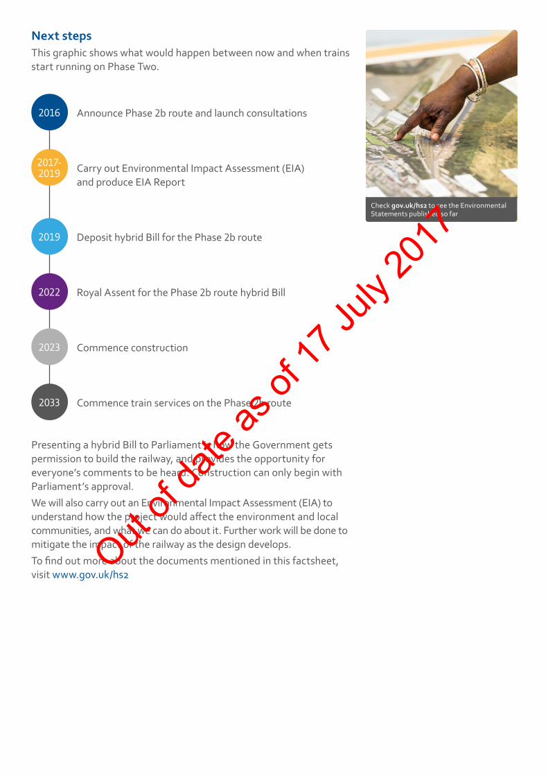
Next stepsThis graphic shows what would happen between now and when trains start running on Phase Two.
2016 Announce Phase 2b route and launch consultations
2017- 2019 Carry out Environmental Impact Assessment (EIA)
and produce EIA Report
2019 Deposit hybrid Bill for the Phase 2b route
2022 Royal Assent for the Phase 2b route hybrid Bill
2023 Commence construction
2033 Commence train services on the Phase 2b route
Presenting a hybrid Bill to Parliament is how the Government gets permission to build the railway, and provides the opportunity for everyone’s comments to be heard. Construction can only begin with Parliament’s approval.We will also carry out an Environmental Impact Assessment (EIA) to understand how the project would affect the environment and local communities, and what we can do about it. Further work will be done to mitigate the impact of the railway as the design develops. To find out more about the documents mentioned in this factsheet, visit www.gov.uk/hs2
Check gov.uk/hs2 to see the Environmental Statements published so far
Out of
date
as of
17 Ju
ly 20
17

Contact us HS2 Helpdesk Tel: 020 7944 4908 Email: [email protected]
This document may be freely downloaded and translated by individuals or organisations for conversion into other accessible formats. If you have other needs in this regard, please contact HS2 Ltd.
The Residents’ Charter is our promise to communicate as clearly as we possibly can with people who live along or near the HS2 route. You can read it by visiting:
www.gov.uk/government/publications/hs2-residents-charter
We also have an independent Residents’ Commissioner whose job is to make sure we keep to the promises we make in the Charter and to keep it under constant review. The first of the Residents’ Commissioner’s reports is published at:
www.gov.uk/government/publications/ hs2-residents-commissioner-report-1-may-2015
You can contact the Commissioner at:
Residents’ Charter and Commissioner
For more information about Phase Two, visit
www.gov.uk/government/collections/hs2-phase-two-from-the-west-midlands-to-leeds-and-manchester
And for details of events in your area, visit
www.gov.uk/government/collections/hs2-events
Project updates
Property and compensation
You can find out all about HS2 and properties along the line of route by visiting:
www.gov.uk/government/collections/hs2-property
You can also find out if you’re eligible for compensation at:
www.gov.uk/claim-compensation-if-affected-by-hs2
To see what jobs are available on HS2 at the moment, check our careers page:
http://careers.hs2.org.uk
If you’re a student wondering what careers in STEM subjects are like, check out articles and have a look around our Plotr World:
www.plotr.co.uk/careers/worlds/hs2
And if you’re a business wondering how to get involved with HS2, have a look at our guides and updates on:
www.gov.uk/hs2 – search for HS2 business
Jobs and skills
Keeping you informedWe are committed to keeping you informed via various channels
High Speed Two (HS2) Limited, Two Snowhill, Snow Hill Queensway, Birmingham B4 6GA
Out of
date
as of
17 Ju
ly 20
17