Embed Size (px)
Citation preview
Warm Up 3/25Warm Up 3/251)1) If Earth did not rotate, how would air at the If Earth did not rotate, how would air at the
equator move?equator move?a.a. Air would sink and move toward the poles.Air would sink and move toward the poles.b.b. There would be no air movement.There would be no air movement.c.c. Air would rise and move toward the poles.Air would rise and move toward the poles.d.d. none of the abovenone of the above
2)2) Near the equator, rising air is associated with a Near the equator, rising air is associated with a pressure zone known as the ____.pressure zone known as the ____.a.a. equatorial lowequatorial low c. equatorial highc. equatorial highb.b. tropical hightropical high d. tropical lowd. tropical low
3)3) Centers of low pressure are called ____.Centers of low pressure are called ____.a.a. air massesair masses c. anticyclonesc. anticyclonesb.b. jet streamsjet streams d. cyclonesd. cyclones
Answers: 1) c. 2) a. 3) d.Answers: 1) c. 2) a. 3) d.
Regional Wind Regional Wind SystemsSystems
Chapter 19, Section 3Chapter 19, Section 3
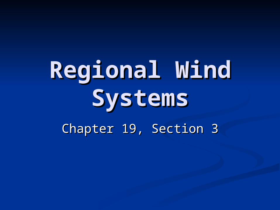
Local WindsLocal Winds The local winds are caused either by The local winds are caused either by
topographic effects or by variations in surface topographic effects or by variations in surface composition—land and water—in the immediate composition—land and water—in the immediate areaarea
During warm summer months, coastal land is During warm summer months, coastal land is heated more intensely than the water, heated more intensely than the water, producing an area of low pressure which the producing an area of low pressure which the cooler ocean air moves into fill, creating a cooler ocean air moves into fill, creating a breeze in the afternoon (sea breeze); at night breeze in the afternoon (sea breeze); at night the reverse may take place (land breeze)the reverse may take place (land breeze)
The same happens in the mountains, with the The same happens in the mountains, with the air from the valley coming up to replace the air air from the valley coming up to replace the air from the mountain slopes (valley breeze); at from the mountain slopes (valley breeze); at night the reverse takes place (mountain breeze)night the reverse takes place (mountain breeze)

Sea and Land BreezesSea and Land Breezes
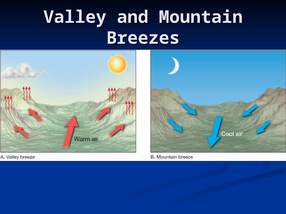
Valley and Mountain Valley and Mountain BreezesBreezes
Concept CheckConcept Check
What type of local wind can form in What type of local wind can form in the Grand Canyon at night?the Grand Canyon at night?
Mountain breezeMountain breeze
How Wind is MeasuredHow Wind is Measured Two basic wind measurements—direction and Two basic wind measurements—direction and
speed—are especially important to the speed—are especially important to the meteorologistmeteorologist
Winds are always labeled by the direction from Winds are always labeled by the direction from which they blowwhich they blow
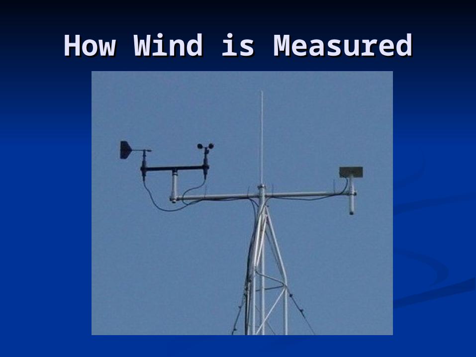
The wind vane is the instrument used to The wind vane is the instrument used to determine wind directiondetermine wind direction
Prevailing Wind – when wind consistently blows Prevailing Wind – when wind consistently blows more often from one direction than from any more often from one direction than from any otherother
In the United States, the westerlies consistently In the United States, the westerlies consistently move weather from west to east across the move weather from west to east across the continentcontinent
Within this general eastward flow are cells of Within this general eastward flow are cells of high and low pressure with the characteristic high and low pressure with the characteristic clockwise and counterclockwise motion which clockwise and counterclockwise motion which cause the westerlies to vary considerably from cause the westerlies to vary considerably from day to day and place to placeday to day and place to place
Anemometer –Anemometer – device to measure wind speed device to measure wind speed
How Wind is MeasuredHow Wind is Measured
Concept CheckConcept Check
Toward which direction does a SE Toward which direction does a SE wind blow?wind blow?
NW (north-west)NW (north-west)
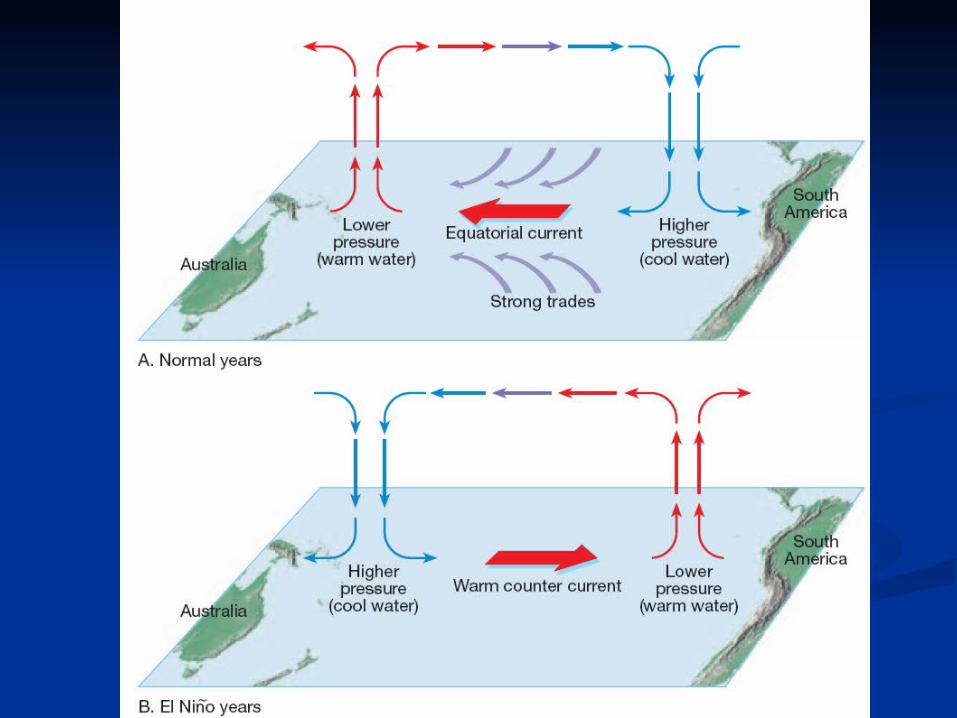
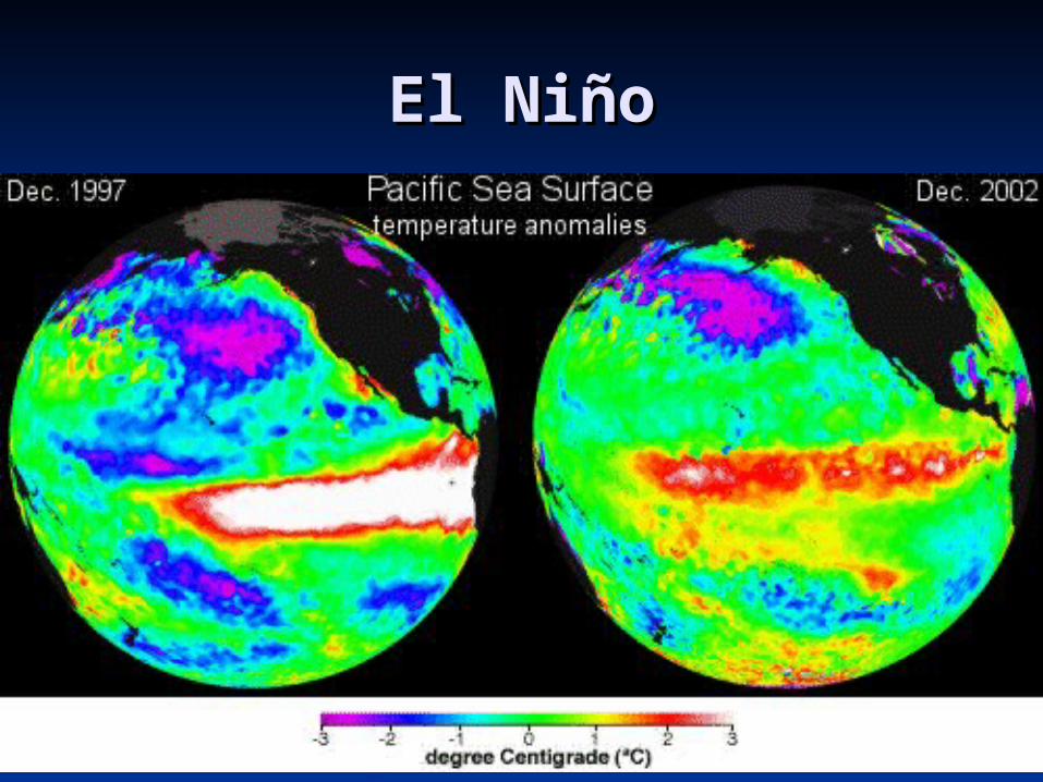
El NiñoEl Niño At irregular intervals of three to seven years, the At irregular intervals of three to seven years, the
warm countercurrents, along the coasts of Peru and warm countercurrents, along the coasts of Peru and Ecuador, become unusually strong and replace Ecuador, become unusually strong and replace normally cold offshore waters with warm equatorial normally cold offshore waters with warm equatorial waters – waters – El NiñoEl Niño
The warm waters block the nutrients from reaching The warm waters block the nutrients from reaching the surface waters, causing many fish to die off, and the surface waters, causing many fish to die off, and greatly affects the fishing industries of Peru and greatly affects the fishing industries of Peru and EcuadorEcuador
Some inland areas that are normally arid get an Some inland areas that are normally arid get an abnormal amount of rain, increasing their crop abnormal amount of rain, increasing their crop productionproduction
These episodes mostly effect the eastern tropical These episodes mostly effect the eastern tropical Pacific, but is a part of the global circulation and Pacific, but is a part of the global circulation and affects the weather all over the worldaffects the weather all over the world
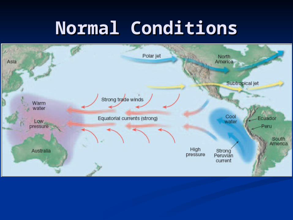
Normal ConditionsNormal Conditions
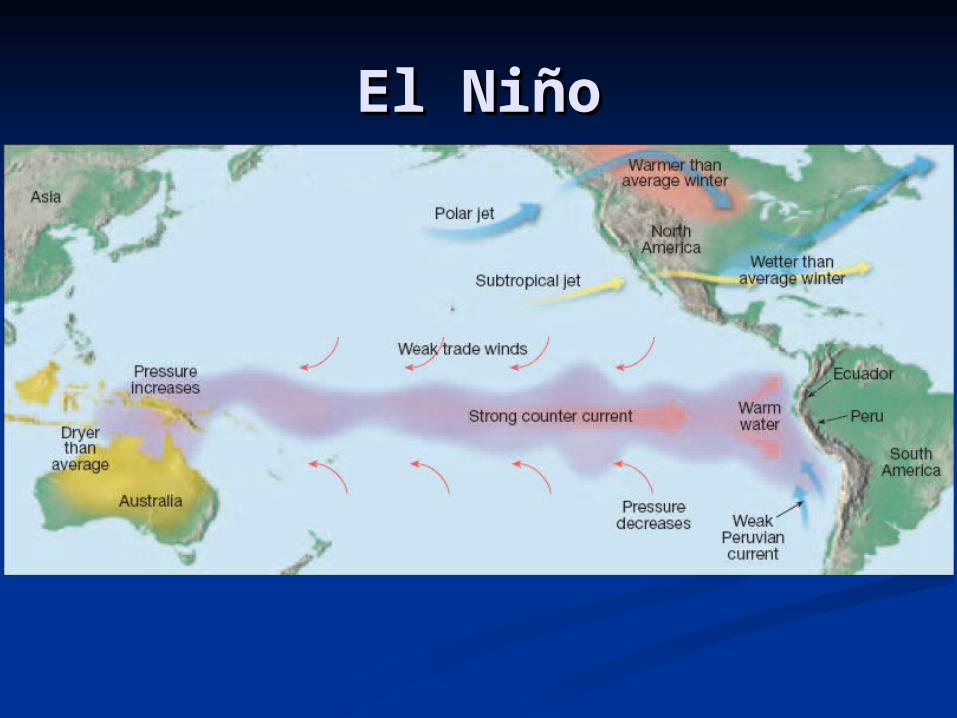
El NiñoEl Niño
El NiñoEl Niño
Concept CheckConcept Check
What is an El Niño and what effect What is an El Niño and what effect does it have on the weather?does it have on the weather?
An episode—occurring every three An episode—occurring every three to seven years—of ocean warming to seven years—of ocean warming that affects the eastern tropical that affects the eastern tropical Pacific; warm countercurrents Pacific; warm countercurrents become unusually strong and become unusually strong and replace normally cold offshore replace normally cold offshore waters with warm equatorial waters.waters with warm equatorial waters.
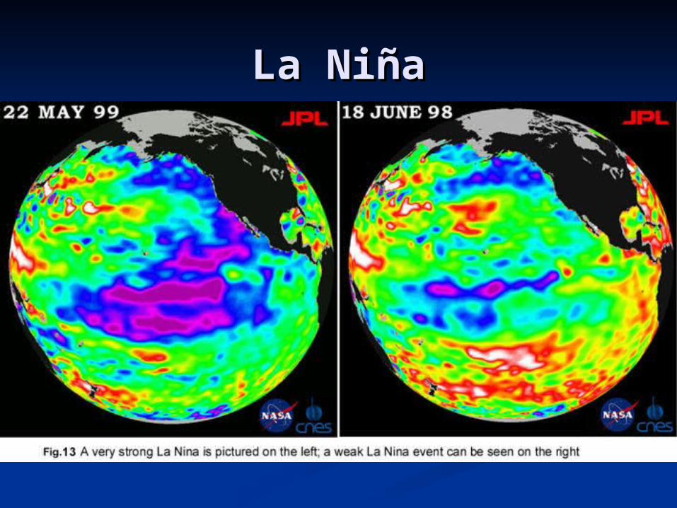
La NiñaLa Niña
The opposite of El Niño is an atmospheric The opposite of El Niño is an atmospheric phenomenon known as La Niñaphenomenon known as La Niña
Researchers have come to recognize that Researchers have come to recognize that when surface temperatures in the eastern when surface temperatures in the eastern Pacific are colder than average, a La Niña Pacific are colder than average, a La Niña event is triggered that has a distinctive set of event is triggered that has a distinctive set of weather patternsweather patterns
A typical La Niña winter blows colder than A typical La Niña winter blows colder than normal air over the Pacific Northwest (with normal air over the Pacific Northwest (with more precipitation) and the Northern Great more precipitation) and the Northern Great PlainsPlains
It warms much of the rest of the United StatesIt warms much of the rest of the United States
La NiñaLa Niña
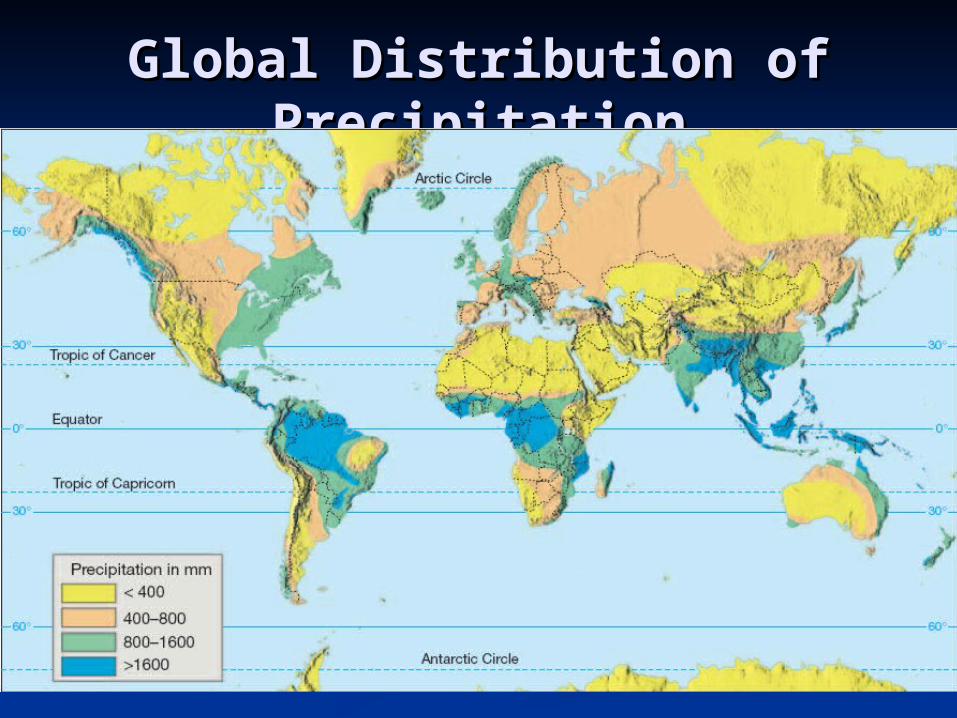
Global Distribution of Global Distribution of PrecipitationPrecipitation
Areas dominated by the convergent Trade Areas dominated by the convergent Trade winds (equatorial low) have mainly rain winds (equatorial low) have mainly rain forests and abundant precipitationforests and abundant precipitation
Areas dominated by the subtropical high-Areas dominated by the subtropical high-pressure cells are regions of extensive pressure cells are regions of extensive desertsdeserts
The interiors of large land masses The interiors of large land masses commonly experience decreased commonly experience decreased precipitationprecipitation
You will be able to explain much about You will be able to explain much about global precipitation through your global precipitation through your knowledge of global winds and pressure knowledge of global winds and pressure systemssystems
Global Distribution of Global Distribution of PrecipitationPrecipitation
Concept CheckConcept Check
What two factors mainly influence What two factors mainly influence global precipitation?global precipitation?
Moisture content of air and Moisture content of air and distribution of land and water.distribution of land and water.
AssignmentAssignment
Read Chapter 19 (pg. 532-549)Read Chapter 19 (pg. 532-549) Do Chapter 19 Assessment #1-29 Do Chapter 19 Assessment #1-29
(pg. 553-554)(pg. 553-554) Study for Chapter 19 QuizStudy for Chapter 19 Quiz