Embed Size (px)
Citation preview

Washington State Department of Transportation
Monument Mapping Engine, v5.0.5
September 28, 2017
By Richard C. Daniels
GIS Support Analyst Information Technology Division
Washington State Department of Transportation Olympia, WA 98504-7430
Kurt Williamson
Geodetic Engineer Geodetic Survey Branch
GeoMetrix Office Washington State Department of Transportation
Olympia, WA 98504-7384
ii
Recommended Citation: Daniels, R.C. and K. Williamson. 2017. Washington State Department of Transportation Monument Mapping Engine, v5.0.5. White Paper, Information Technology Division, Washington State Department of Transportation, Olympia, WA. The Monument Mapping Engine was initially released in 1999 and supports WSDOT’s ongoing geodetic survey activities. It was upgraded in 2001, 2003, 2008, and 2010. In 2015 the application was rewritten to support ArcGIS 10.2/10.3, to use multiple map services, and to support the new ArcGIS JavaScript API. In January of 2016 and June 2017 the servers supporting the application were upgraded to ArcGIS Server 10.3.1, 10.4.1, and 10.5.1, respectively. After each software upgrade the map documents used by the application for the map services were upgraded as well. The current version number of the application to 5.0.5 which runs under ArcGIS Server 10.5.1.
The Mapping Engine uses scale dependent rendering with five different map services to display a variety of services as one zooms into a specific survey station. The applications initial statewide view shows the location of WSDOT’s geodetic survey monuments and National Geodetic Survey’s HARN and CORS stations on top of ESRI’s ™ topographic base map. Washington county boundaries and State Route mileposts are available as well but are not “on” by default. The user may select a WSDOT or NGS monument by clicking on the map. If a monument is found near the position clicked a pop-up window opens that shows basic information about the station and the user can then request the complete data sheet for the station. In the last twelve months the Monument Mapping received an average of 3,263 pageviews per month and in May 2017 had 940 unique users. Based on the cost of installing a monument, the number of site visits, and discussions with members of the professional Land Surveyors’ Association of Washington, WSDOT estimates that the State has achieved over $1.3 million in cost avoidance since the application was initially fielded in 1999.
( http://www.wsdot.wa.gov/monument )

iii
Printed on Recycled Paper
This document is preliminary, has not undergone formal review or editing and is provided for informational purposes only.

1
Washington State Department of Transportation (WSDOT) Monument Mapping Engine, version 5.0.5
The Monument Mapping Engine was first fielded in 1999 as an out of the box ArcView IMSTM application to support WSDOT’s survey activities. At the request of the Geodetic Survey Section, Geographic Services Office (now known as the GeoMetrix Office), the Information Technology Division redeveloped the application using ESRI’s ArcIMS technology; to include support for Digital Raster Graphics (i.e., USGS 7.5’ Topographic maps) and query functions. Development began March 20, 2001 and was completed on April 12, 2002. The application was ported with minimal changes in September 2008 to ArcIMS 9.2 and a new server, updated in 2010, and rewritten in 2014. At the release of ArcGIS 10 in 2010 the image map service technology used by the Monument Mapping Engine application was removed from ArcIMS by ESRITM. This necessitated the fourth major upgrade of the application. In March 2011 the new Monument Mapping Engine, known as version 4.0, was released. This is the first version of this application to run as a native ArcGIS Server application. In 2014 ArcGIS 10.2 and 10.3 was released. This release changed the way that maps services are published on the server (i.e., as a tiled service vs. an image service) and introduced a new ArcGIS JavaScript application programming interface (API). The recommended way that an application handled map services changed as well. In the past a single map service usually contained all the map layers needed for an application. At 10.2 it is recommended that each layer be its own map service, this allows the map services to be reusable and distributed across several servers. At version 5.0 of the Monument Mapping Engine multiple ArcGIS Map Services are used, these are located on several ArcGIS Servers. The application now utilizes up to five feature services at a time and two supporting utility services (e.g., print). This version was upgraded to version 5.0.1 in 2016, 5.0.2 and 5.0.5 in 2017 when the supporting ArcGIS Servers were upgraded to 10.3.1, 10.4.1 and 10.5.1, respectively. The applications initial statewide view shows the location of WSDOT’s geodetic survey monuments, National Geodetic Survey’s HARN and CORS stations, and county boundaries and State Routes mileposts on top of a ESRITM topographic base map (Figure 1). Within the application red triangles indicate the location of survey monuments maintained by the Washington State Department of Transportation. Blank symbols (e.g., circles, triangles) show the location of National Geodetic Survey survey stations. In the past as one zoomed into the map past a scale of 1:250,000 the shaded relief map was replaced with a color 1:250,000 scale USGS topographic map. If you continued to zoom in past 1:50,000, the 1:24,000 scale USGS maps (a.k.a., 7.5 minute topographic quadrangles) turned on. At 1:12,000 and larger scales the topographic maps was replaced with air photography from the Washington State Orthophoto Partnership. At this release scale dependency is still used but the underlying base map does not change as describe above. Instead the user is provided 13 different base map to choose from. To change from the default ESRITM topographic map click on the applications “Basemaps” tab. This tab

2
provides access to 13 possible background maps, to include a standard WSDOT Basemap (Figure 2). Figure 1. Initial screen received when visiting the Monument Mapping Engine.

3
Figure 2. The base map used as the backdrop for the application can be changed by the user in the “Basemaps” tab.
Using the tools available (see Table 1) within the application the user can zoom into their area of interest and then interactively select a monument, print a map (Figure 3), measure area, distance, and determine the coordinates of any point on the map and retrieve a site description/data sheet for a selected WSDOT geodetic monument or NGS survey station (Figure 4). Note that within the application two data layers are selectable but only one is active at any given time. The selectable layers are the WSDOT Survey Monuments and NGS Survey Station. The Identify and Select tools work on these layer. By default the WSDOT Geodetic Survey Monuments is the initial “active” layer. You may use the radio buttons found in the “Tools” tab to select or change the currently active layer.

4
Table 1. Tools available within the Monument Mapping Engine.

5
Figure 3. Example of a printable “to reach” map for survey monument IS3418 –highlighted in blue.
6
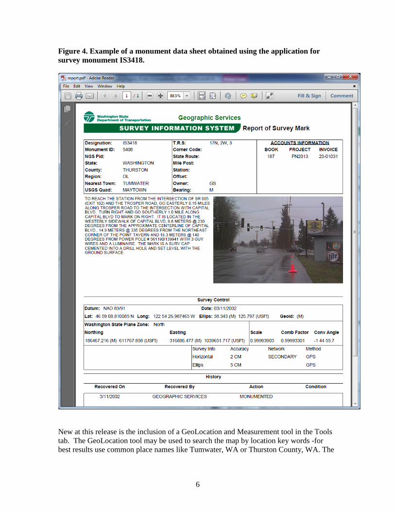
Figure 4. Example of a monument data sheet obtained using the application for survey monument IS3418.
New at this release is the inclusion of a GeoLocation and Measurement tool in the Tools tab. The GeoLocation tool may be used to search the map by location key words -for best results use common place names like Tumwater, WA or Thurston County, WA. The

7
Measurement tool can be used to measure areas, distances, and determine the coordinates of any point on the map. To support field use and small screen devices such as smartphones the tab bar may be minimized and there is a new “zoom to my location” button on the left side of the screen (Figure 5). When clicked the application zooms into your current location. Location is obtained from your devices GPS (if enabled), your wireless or cell network, or an estimated location is made based on your computers IP Address. If you use the application on a small screen device the WSDOT banner bar is not displayed and the GeoLocation and Measurement tools are unavailable. Figure 5. Monument Mapping Engine application as seen on a small screen device with the tab bar minimized and maximized.
8
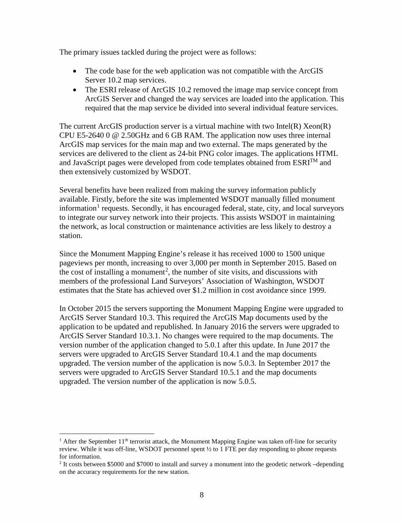
The primary issues tackled during the project were as follows:
• The code base for the web application was not compatible with the ArcGIS Server 10.2 map services.
• The ESRI release of ArcGIS 10.2 removed the image map service concept from ArcGIS Server and changed the way services are loaded into the application. This required that the map service be divided into several individual feature services.
The current ArcGIS production server is a virtual machine with two Intel(R) Xeon(R) CPU E5-2640 0 @ 2.50GHz and 6 GB RAM. The application now uses three internal ArcGIS map services for the main map and two external. The maps generated by the services are delivered to the client as 24-bit PNG color images. The applications HTML and JavaScript pages were developed from code templates obtained from ESRITM and then extensively customized by WSDOT. Several benefits have been realized from making the survey information publicly available. Firstly, before the site was implemented WSDOT manually filled monument information1 requests. Secondly, it has encouraged federal, state, city, and local surveyors to integrate our survey network into their projects. This assists WSDOT in maintaining the network, as local construction or maintenance activities are less likely to destroy a station. Since the Monument Mapping Engine’s release it has received 1000 to 1500 unique pageviews per month, increasing to over 3,000 per month in September 2015. Based on the cost of installing a monument2, the number of site visits, and discussions with members of the professional Land Surveyors’ Association of Washington, WSDOT estimates that the State has achieved over $1.2 million in cost avoidance since 1999. In October 2015 the servers supporting the Monument Mapping Engine were upgraded to ArcGIS Server Standard 10.3. This required the ArcGIS Map documents used by the application to be updated and republished. In January 2016 the servers were upgraded to ArcGIS Server Standard 10.3.1. No changes were required to the map documents. The version number of the application changed to 5.0.1 after this update. In June 2017 the servers were upgraded to ArcGIS Server Standard 10.4.1 and the map documents upgraded. The version number of the application is now 5.0.3. In September 2017 the servers were upgraded to ArcGIS Server Standard 10.5.1 and the map documents upgraded. The version number of the application is now 5.0.5. 1 After the September 11th terrorist attack, the Monument Mapping Engine was taken off-line for security review. While it was off-line, WSDOT personnel spent ½ to 1 FTE per day responding to phone requests for information. 2 It costs between $5000 and $7000 to install and survey a monument into the geodetic network –depending on the accuracy requirements for the new station.