Embed Size (px)
Citation preview

*Mark of Schlumberger
Water and Oil Do Mix! A Discussion on How Leading – Edge
Oil Field Technologies are Applied to Groundwater Applications
By Ken Campbell P.Geol Senior Hydrogeologist
Schlumberger Water Services 1.0 Introduction Groundwater is essential for life; it provides drinking water for human consumption, sustains ecosystems, irrigates drought-stricken farms, and supports modern industry. However, global population growth and urban expansion are placing greater demand on groundwater resources and amplifying the need for sustainable groundwater resource management and planning. While the technologies and tools that have been available to the hydrogeologist have served us well, we now find ourselves on the verge of a major leap in the application of Advanced Hydrogeological Technologies to groundwater development and groundwater management challenges. By definition, an Advanced Hydrogeological Technology is a multifaceted or sophisticated technology that is capable of precise evaluations of complex hydrogeological settings – yet has not customarily been used in mainstream hydrogeological investigations. Advanced Hydrogeological Technologies include either: 1) new technologies, the development of which has been driven by increased market pressure to apply more precise science to the management of water issues, or 2) the application of existing technologies that have been utilized in the energy sector, but because of market conditions, have not been economically viable for water projects. The application of Advanced Hydrogeological Technologies is commonly applied within the framework of a more formalized workflow than is customarily the case with classical hydrogeological assessments. This workflow, shown schematically in Figure 1, is developed specifically for each project, and incorporates input from a number of disciplines. This paper focuses on four leading-edge technologies that are being used in integrated groundwater projects, and have application in Alberta. These technologies include:
• Data Acquisition and Monitoring (including Hydrodynamic Testing and Data Management)
• High Resolution Borehole Geophysics • Advanced Modeling • Aquifer Storage and Recovery

*Mark of Schlumberger
Figure ---Advanced Hydrogeological WorkflowSurface imaging MappingEM survey interpretationData input
Information managementGIS database
3D geological model3D hydrogeological modelHydrogeological conceptual model
Log interpretationWell correlationSurface identificationSurface/subsurface interaction
Uncertainty analysisUpscaling processesAquifer property population
CalibrationHistory matchPost processingPresentation
Data analysisFacies modellingFault modellingFracture modellingHydrodynamic test analysis
3D flow and mass transport simulationSaturated and variably saturated conditionsDensity dependent modelingGeomechanics
EclipseVModflowFeflow
2.0 The Case for Advanced Hydrogeological Technologies While some of the technologies that we refer to as “Advanced Hydrogeological Technologies” have been in use in the oil and gas sector for some time, these same technologies have not found a place in the hydrogeological sector. Other of the Advanced Hydrogeological Technologies evolved in the hydrogeological sector in response to a specific need. Invariably advanced technologies of any sort evolve in response to some need or driver. Thus it is important at the outset to consider what those drivers are and realize what technologies become usable in the hydrogeologist’s toolbox. In general, Advanced Hydrogeological Technologies have application:
• when the investigation is deep, • when the investigation is in a complex hydrogeological setting, or • when there is limited tolerance for uncertainty in the results of the
investigation on the part of regulators or investors. 3.0 The Evolution of Advanced Hydrogeological Technologies The various technologies that have been developed to address groundwater exploration and development are generally similar to the technologies developed to conduct oil and
Figure 1: Advanced Hydrogeological Workflow

*Mark of Schlumberger
gas exploration and development. The specific technologies that evolved in each of these resource sectors did so in response to specific market pressures. The two key factors that made the difference between the technologies that developed in each sector were: 1) value of the pursued resource - oil and gas having a much higher market value than groundwater, and 2) the depth of investigation - groundwater investigations in pursuit of potable water generally focused on the zone from ground surface to 300 metres in depth, while oilfield exploration has historically had a deeper focus, with limited interest in zones less than 600 metres. 4.0 Advanced Hydrogeological Technologies The list of technologies that may be considered Advanced Hydrogeological Technologies is expansive. A short list is considered in this presentation, based on technologies that have immediate applicability to Western Canada. This short list includes:
• Data Acquisition and Monitoring • Data Management • Hydrodynamic Testing • Borehole Geophysics • Advanced Modeling • Aquifer Storage and Recovery
4.1 Data Acquisition and Monitoring A key component in any hydrogeological program is the generation, recording and interpretation of subsurface data. The ongoing monitoring of the response of aquifers to hydraulic and geochemical stresses requires specialized equipment. In response to the increased depth of hydrogeological programs and the cost of data collection, specialized technologies have been developed that are both cost effective and technically superior to the tools and techniques used in classical hydrogeological investigations. 4.1.1 Groundwater Dataloggers
Until recently, groundwater level measurements were measured manually using electric tapes. This technology has limitations imposed by the manpower cost of having a person on site physically making each measurement, and the limitation implicit in taking repeated water levels during rapid water level response, or at depths. In addition, reliability during cold weather is an issue with electric tapes.

*Mark of Schlumberger
Although electric tapes continue to be a valuable tool for the hydrogeologist, increasingly, we see the manual downhole measurements being supplemented by the use of dataloggers coupled to downhole pressure and sensing devices. Because the dataloggers have the ability to measure and record water levels at an unprecedented rate, dataloggers must also have the ability to store large volumes of data. Today’s advanced loggers are capable of measuring water levels, temperature, and in some cases conductivity. To facilitate the downloading of this data, dataloggers are commonly provided with software allowing the data to be downloaded from the logger to a laptop. More advanced water level dataloggers, such as the Diver* (Figure 2), can be downloaded remotely to a laptop or PDA, and can even accommodate satellite data download and transmission.
Figure---- Data Loggers and Data Transfer
4.1.2 Multilevel Groundwater Monitoring Groundwater applications where more data is required than can be economically achieved using standard monitoring wells have led to the development of multilevel groundwater monitoring systems. These systems provide the ability to collect groundwater data from multiple levels in a single borehole. Similar to oilfield technologies, the Westbay* System utilizes a combination of packers and ports to isolate discrete zones for characterization and monitoring (Figure 3). Access to the isolated zone is provided by wireline tools. Using the Westbay Multi-level system, an unlimited number of monitoring zones can be created in a borehole, providing detailed vertical pressure profiles, permeability data and groundwater samples, as shown in Figure 4.
Figure 2: Dataloggers and Data Transfer

*Mark of Schlumberger
Figure ---- Westbay Monitor System
Packer- reliable seal for a range of borehole sizes
Measurement Port- for fluid sampling and in-situ measurement
Pumping Port- for hydraulic conductivity testing and purging
Casing- variable lengths
Mon
itorin
g Zo
ne
Figure---- Capability of Westbay MonitoringPressureProfile
Pressurevs. Time
HydraulicTests
PermeabilityProfile
Water QualityProfile
Water Qualityvs. Time
Figure 3: Westbay Monitoring System
Figure 4: Capability of Westbay Monitoring

*Mark of Schlumberger
4.2 Data Management The hydrogeological programs of today have an increasing temporal and spatial aspect which requires the storage, processing, and manipulation of large volumes of hydrogeological data. All the data collected by drilling and logging wells, running test cycles of injection/pumping, preparing and running numerical models, and on-going water level monitoring will generate volumes of data that need to be managed properly to help in meeting project objectives and making decisions. In order to provide for cost effective data management, databases are used when the capability of conventional spread sheet technology has been maximized, and where specialized functions and interfacing is required with monitoring function of other databases. A broad database capability can be developed and maintained using advanced software such as Hydromanager* and HydroGeo Analyst*. The desired result is the seamless integration of data from “field to desk”, allowing for efficient data storage, analysis and presentation. A typical database structure for hydrogeological data is presented in Figure 5. Figure 5: Typical Database Structure
Security
Regional Offices, Public, etc.
Local/Wide Area Network
Central Database(SQL Server 2005)
Desktop Solution
HydroGeo Analyst
Analysis,Interpretation, Visualization &
Reporting
HydroManager
Web Interface
Ministry Staff
Water Quality
AquaChem Water Quality Analysis
Pumping Test
AquiferTest Pumping Test Analysis
Automated Data Acquisition
Raw Data
Data LoggersOther DBs
Sync
hron
izatio
n
-GIS-eServices-Data access
Central Database(SQL Server 2005)

*Mark of Schlumberger
4.3 Hydrodynamic Testing Historically the interpretation of aquifer test data has been a laborious and costly undertaking, primarily due to the amount of time required to process and plot pump test data into a format specific to the particular analytical approach selected to evaluate the test results. The development of software packages such as AquiferTest* has provided a solution. These programs can process and plot well test data, and provide automated calculation of formation coefficients using a selectable range of analytical interpretation techniques. The ability of AquiferTest to accommodate large volumes of test data transferred from dataloggers is an essential time saver. Graphic output from the software analysis is report ready. A recent advance in AquiferTest incorporates the use of “derivatives” to assist in the evaluation of aquifer test results (Figure 6). The standard analytical solutions utilized by hydrogeologists to interpret aquifer test data are applicable to single phase flow problems, as is the rule in most shallow aquifers. Figure 6: Results from AquiferTest

*Mark of Schlumberger
In addition, as hydrogeological programs focus on deeper aquifers, hydrogeologists are faced with the need to interpret aquifer test data from formations where 2 phase flow (usually gas and water) is occurring. In such situations, the application of reservoir engineering packages such as WellTest may be used to interpret the hydrogeological test data. Further, WellTest has advanced derivative capabilities, as well as the ability to determine “skin” effects that current hydrogeological test software can not do.
4.4 Borehole Geophysics Borehole geophysics is such an integral part of oil field exploration and production, that it is difficult to contemplate life in the oil patch without it. Nonetheless, borehole geophysics has not gained the same level of acceptance and utilization in the water well sector and in hydrogeological investigations in shallow aquifers, primarily due to cost factors and technology scale. However, as hydrogeological investigations have begun to focus on deeper aquifers, the advanced borehole geophysical tools (used as standard practice in the energy sector) become usable by the hydrogeologist. 4.4.1 Advanced Wireline Applications Beyond the standard suites of wireline geophysical tools used in standard practice; High-Resolution Borehole Geophysics provides the detailed characterization data that are essential for building robust predictive models. A typical suite of Schlumberger Advanced logs including AIT, CMR, FMI and ECS is shown in Figure 7 , providing hydrogeologic properties, formation properties, geochemistry, and geomechanical properties. During large-scale aquifer evaluation projects, high resolution borehole geophysics and image logging technologies utilized in the oilfield are used to provide the foundation for detailed aquifer characterization and valuable conceptual model development. These logs show portions of clay, dolomite, sand, and free water in a multilayer aquifer with layers of confining clays and porous dolomites. The high resolution from these logs is capable of showing extremely detailed information whereby the clay is not pure clay, but a multilayer in itself with a high component of calcite. These logs also allow for an understanding of the formation dip of the strata, which is key to understanding preferential flow in some bedrock aquifers. Technologies utilized in this aquifer characterization are being used for a variety of groundwater projects around the world.

*Mark of Schlumberger
4.5 Advanced Modeling – Petrel*/ECLIPSE H2O The development of computing methods, particularly the development of finite difference and finite element methods, has given hydrogeologists the ability to apply desktop computer technologies and software to a wide range of hydrogeological problems. Today, Visual MODFLOW* and FEFLOW are the most commonly used groundwater modeling software programs. These programs have their place in groundwater applications, and have served the hydrogeologist well. However, as hydrogeological applications become more complex, they require the advanced capacity of oilfield reservoir models like Petrel/ECLIPSE, which is far more powerful than the standard hydrogeological models. Oil field computer models, while similar to hydrogeological models, are capable of simulation of three phase problems (gas, oil, and water), whereas hydrogeological models commonly handle only single phase flow. By virtue of their evolution, oilfield models have been designed to integrate oil field data including both borehole and surface geophysics. In the oil field setting, large volumes of high quality digital data can be integrated into the static model Petrel and processed utilizing the facies and statistical modules to produce a superior hydrogeological understanding (Figure 8). While Visual MODFLOW runs simulations from an external (often manually developed) conceptual hydrogeological model; Petrel, conversely integrates, and processes large volumes of data
Figure 7: Advanced Logging Results

*Mark of Schlumberger
into a “static” model, with the option of running the simulations using Visual MODFLOW, FEFLOW or ECLIPSE. The benefits of the advanced Petrel/ECLIPSE modeling package include:
• Integrating aquifer characterization and numerical simulation (large regional models, 500+ wells)
• Fully 3D density-dependent and unsaturated flow and mass transport • Multi-phase flow (Water – Air – DNAPL/LNAPL) • Capillary and relative permeability hysteresis • Dual porosity/dual permeability modeling • Smart local grid refinement, allowing for more realistic near wellbore
results and faster simulation runs • Volumetric budgets for water and air • Advanced well controls/models • Geomechanics
As the use of oilfield data becomes more prevalent, so does the use of other oilfield software developed to process wireline data. Programs such as PetroDesk, GeoFrame, and Oilfield Manager, ease the processing and manipulation of oil field data into a format usable by the hydrogeologists.
Figure ------Facies Modeling Using Petrel
In Alberta, Petrel has been utilized to characterize potential injection/disposal zones for a confidential SAGD development in northeastern Alberta. In this case, the proponent was already using Petrel/ECLIPSE for the reservoir simulation. With nominal additional effort, the static model was upgraded to include Devonian strata. Additional data added included core data, geological picks, 3D seismic data, and groundwater geochemistry from sampling programs previously executed. The use of the Petrel model has facilitated
Figure 8: Facies Modeling Using Petrel

*Mark of Schlumberger
the identification of pre-glacial channel aquifers that are incised into both the McMurray Formation and the Devonian strata as well as structural highs on the Precambrian surface that influences groundwater flow in the Devonian. 4.6 Aquifer Storage and Recovery
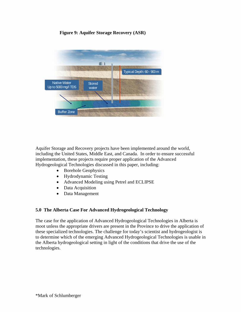
Aquifer Storage and Recovery (ASR) is not a technology per say, but a water management technique made possible through the bundling and application of Advanced Hydrogeological Tools. By definition, ASR is the storage of water in a suitable aquifer through a well during times when water is available and recovery from the same well during times when it is needed (Pyne, 1994). An ASR is not unlike the Gas Storage Projects (GSP) that have been operational in southern Alberta for several decades; and the Carbon Sequestration concepts being currently contemplated. The subsurface requirements for ASR, GSP, and Carbon Sequestration are similar; the stored fluid is just different. ASR can provide economical, efficient, secure storage which is 4 to 10 times more cost effective than reservoirs or storage tanks. ASR requires much less surface infrastructure and facilitates peak flow shaving, optimizing water resource utilization. Depending on site conditions, ASR can be carried out at depths ranging anywhere from 60 to 900m, in confined or unconfined aquifers, and in a variety of geologic materials. ASR can be carried out in fresh water or saline aquifers (the maximum salinity is usually 5000 mg/l Total Dissolved Solids). As shown in Figure 9, the injected water is traditionally shown radiating from the injection well as a bubble, with a buffer zone between the injected water and the natural formation groundwater. Since groundwater doesn’t normally move very fast, once it is injected into the ground it is available to be pumped back to the surface when required. Recovery pumping can be done using the injection well, or a separate well down gradient.
*Mark of Schlumberger
Figure-----Aquifer Storage Recovery (ASR)
Typical Depth: 60 - 900 mTypical Depth: 60 - 900 m
Native WaterUp to 5000 mg/l TDS
Native WaterUp to 5000 mg/l TDS
Storedwater
Storedwater
Buffer ZoneBuffer Zone
Aquifer Storage and Recovery projects have been implemented around the world, including the United States, Middle East, and Canada. In order to ensure successful implementation, these projects require proper application of the Advanced Hydrogeological Technologies discussed in this paper, including:
• Borehole Geophysics • Hydrodynamic Testing • Advanced Modeling using Petrel and ECLIPSE • Data Acquisition • Data Management
5.0 The Alberta Case For Advanced Hydrogeological Technology The case for the application of Advanced Hydrogeological Technologies in Alberta is moot unless the appropriate drivers are present in the Province to drive the application of these specialized technologies. The challenge for today’s scientist and hydrogeologist is to determine which of the emerging Advanced Hydrogeological Technologies is usable in the Alberta hydrogeological setting in light of the conditions that drive the use of the technologies.
Figure 9: Aquifer Storage Recovery (ASR)

*Mark of Schlumberger
5.1 Economics The cost of water is increasing, both in a global context and in the Alberta setting. Increased utilization and competition for our Province’s water resources and increased public concerns have driven industrial groundwater users to focus below the groundwater protection zone.
• The application of classical hydrogeological investigation using standard hydrogeological approaches is cost prohibitive at the depths currently under consideration. As the cost of drilling in the heavy oil areas approaches (and indeed exceeds) 1 million dollars, there is increased focus on technologies that can reduce drilling and reduce costs
• The capital cost, (and particularly the upfront costs) associated with both open pit
and in-situ heavy oil development is huge. Thus there is pressure on the part of investors to seek to reduce any uncertainties related to the viability of the proposed venture. Security of water supply is one of the areas where there is uncertainty, and the maximum effort is extended to reduce that uncertainty.
5.2 Regulatory Setting The regulatory setting in Alberta tends to be performance based, and is aimed at providing protection to the Province’s aquifers, as well as existing and future groundwater users. Increased public concern regarding the use of potable water by the energy sector has led to the adoption of the “Groundwater Allocation Policy”. The goal of the Groundwater Allocation Policy was to discourage energy companies from using potable water for oilfield use. As a result, the focus of hydrogeological investigations for industrial groundwater supplies began to focus on deeper aquifers that were not considered “potable”. That was in many cases at depths greater than 150 metres. The net effect of the regulatory adjustments to management and allocation of groundwater management is to push groundwater investigation and development projects into the depth ranges previously considered the purview of oilfield technologies. On the positive side of the exploration cost equation – as exploration depths increase, previously cost prohibitive oilfield technologies and data become usable for hydrogeological investigations. In fact, the existing databases of high quality borehole geophysical data maintained by the ERCB has an incalculable value to the hydrogeologist. These databases will provide the same function of providing data to hydrogeologists exploring below the Groundwater Protection Zone, as the Alberta Environment Groundwater Database provides to the hydrogeologists working in zones above the base of the Groundwater Protection Zone.

*Mark of Schlumberger
5.3 Oil Sands
As we approach the maximization of our water resource base, Oilsands and Heavy Oil Development projects (which are capital intensive at the front end), become increasingly sensitive to technical uncertainty related to the security of water supply. This sensitivity translates into technology intensive groundwater exploration and development projects where advanced Hydrogeological Technologies can make a major contribution, and innovative water management approaches will be implemented to provide security of water supply.
To increase production at current predicted rates, larger scale infrastructure will be required, including:
- storing large volumes of water in on-site structures like tanks, and - storing even larger volumes in off-stream reservoirs.
Because building large scale reservoirs or using massive storage tanks is a costly, labor intensive prospect that requires large surface area, Aquifer Storage and Recovery becomes an attractive prospect for Oil Sands operators.
5.4 Geological Complexity It almost goes with out saying that in spite of the apparent layer cake nature of the Western Canada Sedimentary Basin, the geological complexity of both Unconsolidated and Bedrock Aquifers create challenges to the hydrogeologist tasked with the exploration, development and management of our groundwater resources. These geological uncertainties associated with complex settings call for ever more sophisticated and precise tools and methodologies. (Figure 10)

*Mark of Schlumberger
Figure ------ Geological Complexity - Bedrock
Nardin et al. 2007
5.5 Aquifer Storage and Recovery in Alberta ASR provides economical, efficient, and secure water storage. ASR has been proven to be 4 to 10 times more cost effective than reservoirs or storage tanks primarily because it requires much less surface infrastructure. Of utmost importance to Oil Sands operators, ASR provides the opportunity to store water when Athabasca River flows are high, and use that water when the river flows are low or restricted. In order for ASR to be usable in Western Canada, three basic criteria must be met. 1) There must be a need for this type of water management, 2) The technology must be applicable, 3) The implementation must be cost effective. The Alberta Geological Survey reports that as of 2005, there were an estimated 69 projects in the United States with 100+ in the planning stage. In Canada, one new ASR project has been identified for Kitchener-Waterloo. General observations of the US experience:
• Number of ASR projects is increasing over time, • Local geology controls type of aquifer storage injection zone, • Most stored a combination of surface water and groundwater.
The Alberta Geological Survey has suggested a number of geological zones as potential targets for development of ASR projects. The majority of the targets suggested by AGS (Parks 2005) are in the Cretaceous or Quaternary. It is suggested that deeper targets in the Devonian should be included in an initial (but not all inclusive) list of potential target formations.
Figure 10: Geological Complexity - Bedrock

*Mark of Schlumberger
• Drift Aquifers • Empress Formation • Paskapoo Formation • Edmonton Group • Belly River Formation • Milk River Formation • Mannville Group • Devonian
6.0 Conclusions The ever increasing utilization and development of our water resources has increased the value of water not only in Alberta, but globally. Classical hydrogeological techniques and tools remain usable in some situations; however, the depth of hydrogeological investigations is increasing, and the importance of the decisions based on these investigations is becoming more crucial than ever. As a result, the cost effectiveness of utilizing classical hydrogeological tools is decreasing when compared to alternative oilfield or Advanced Hydrogeological Technologies. . These advanced hydrogeological technologies have application:
• When the investigation is deep • When the investigation is in a complex hydrogeological setting • When there is limited tolerance for uncertainty in the results of the
investigation on the part of the regulators, or the investors As the capital cost of energy development projects increase, so the tolerance for risk decreases. In this way, ASR provides a means of supplementing water supplies, and is a cost effective option when compared to conventional surface storage as surface land requirements for ASR is significantly reduced. While ASR technology is not off-the-shelf technology, it has been applied successfully in a number of geographic and geological settings, including Canada, the Middle East, Florida and California. We have water shortages in Northern and Southern Alberta (i.e. Oil Sands/ Athabasca River) that could be relieved by temporary storage. The applicability of ASR will be the focus of a pre-feasibility study in Alberta in 2008. The study will be funded and executed by Schlumberger and will be made available to the public. In making the adjustment to the increased utilization of advanced technologies, the hydrogeologist must become part reservoir engineer part hydrogeologist. There is an ongoing need for training and re-tooling in response to emerging technological advances, advances that will allow us to meet the subsurface challenges that must be solved in order for us to realize our economic objectives sustainably and with certainty.