Embed Size (px)
Citation preview
5th INTERNATIONAL CONFERENCE
Contemporary achievements in civil engineering 21. April 2017. Subotica, SERBIA
| CONFERENCE PROCEEDINGS INTERNATIONAL CONFERENCE (2017) | 705
WATER MANAGEMENT ON TOPLICA RIVER IN
CHANGING CLIMATE
Marija Ivković 1
Aleksandra Kržič 2 UDK: 556:551.583
DOI:10.14415/konferencijaGFS2017.075 Summary: It is expected that the future climate changes will affect the water balance
components in the river catchments, verily causing changes in water regime. This will also
have implications on water supply, irrigation systems, renewable energy sources,
industrial production as well as whole ecosystems, therefore it is crucial to quantify those
changes. IPCC CO2 emission scenarios and used climate models forms different possible
future meteorological conditions on Toplica river catchment. Hydrological projections
are obtained by forcing the HBV model with the precipitation and temperature data of an
atmosphere-ocean coupled regional climate model RCM-SEEVCCC, run with two global
climate models, ECHAM5 and its previous version SINTEX-G, under the A1B IPCC/SRES
scenario. In addition to these simulations, hydrological simulations run by bias corrected
results of the ECHAM5/RCM-SEEVCCC for A2 scenario and CMCC-CM/NMMB model
for the new IPCC scenario RCP8.5 are done as well. The impact of different scenarios
and their implications on Toplica river water management are presented in this paper.
Keywords: climate change, water management, Toplica
1. INTRODUCTION
Water management planners are facing considerable uncertainties on future demand and
availability of water. Climate change and its potential hydrological effects are increasingly
contributing to this uncertainty. The increasing trend in temperature over the past decades
is likely to continue during the 21st century [1]. With this warming, precipitation
characteristics are also expected to change [2]; more precipitation is expected to fall in the
form of extreme events. This will lead to a more vigorous hydrological cycle, with changes
in precipitation and evapotranspiration rates regionally variable. These changes will in
turn affect water availability and runoff and thus may affect the rivers discharge regime.
The potential effects on discharge extremes that determine the design of water
management regulations and structures are of particular concern, since changes in
extremes may be larger than changes in average figures.
For an adequate management of the water resources it is important to understand the
pattern how temperature and precipitation will change and how the basin will respond.
Different climate scenarios, applied in climate projections, are represented with different
1 Marija Ivković, civil engineer, Republic Hydrometeorological Service of Serbia, Belgrade, Serbia, tel.no.:
+381 64 6801145, e - mail: [email protected] 2 Aleksandra Kržič, meteorologist, Republic Hydrometeorological Service of Serbia, Belgrade, Serbia
5. МЕЂУНАРОДНА КОНФЕРЕНЦИЈА
Савремена достигнућа у грађевинарству 21. април 2017. Суботица, СРБИЈА
706 | ЗБОРНИК РАДОВА МЕЂУНАРОДНЕ КОНФЕРЕНЦИЈЕ (2017) |
storylines that embody our potential future practices. They make varying assumptions
regarding future global population growth, technological development, globalization, and
societal values. Better understanding how the water balance fluxes will change in the
future is possible if we force the same hydrological model with precipitation and
temperature data obtained with different combination of the global and regional climate
models and different emission scenarios.
Hydrological projections for Toplica river basin were simulated with the lumped
IHMS/HBV model with daily time step. The river discharge is obtained from HBV
simulations with the results of an atmosphere-ocean coupled regional climate model
RCM-SEEVCCC, run with two global climate models, ECHAM5 and its previous version
SINTEX-G, under the A1B IPCC/SRES scenario [3]. In addition to these simulations,
hydrological simulations run by bias corrected results of the ECHAM5/RCM-SEEVCCC
for A2 scenario and CMCC-CM/NMMB model for the new IPCC scenario RCP8.5 are
done as well. Defined scenarios are used to force climate models that enable
assessment of possible changes of climate conditions depending on the chosen
scenario. In regard to GHG concentration, A1B is characterized as “medium” and A2 as
“strong” scenario, while the RCP8.5 scenario exceeds both of them.
The objective of this paper is to investigate how two “strong” emission scenarios and used
models will define possible climate change impact on water regime and water resources
on Toplica River. It is expected that the changes in the climate data will affect the water
balance components in the catchment, verily causing changes in water regime and have
implications on water supply, irrigation systems, renewable energy sources, industrial
production as well as whole ecosystems, so it is important to quantify these changes.
2. METHODS
CASE STUDY AND DATA Toplica River originates under the highest peaks of
Kopaonik Mountain. Untouched nature, numerous hot springs with different temperatures
and mineral compositions, preserve its water quality. Seasonal runoff variation is one of
the main reason why the accumulation Selova is built there. The accumulation will provide
better water supply of the surrounding settlements, flood protection and make water
available for irrigation and hydropower production.
The catchment of Toplica River covers the area of 2231 km2. The mean areal elevation of
the catchment is 720 m a.s.l. Cultivated crops dominate the areas under 800 m a.s.l. while
the forests are predominant on more elevated areas. Data from the two meteorological
stations Niš (202 m a.s.l.) and Kuršumlija (382 m a.s.l.), in period from January 1985 to
January 2010, are used in the study. The discharge data from hydrological station Doljevac
are available for the same period. The water regime of the rivers in the southern part of
Serbia is mostly driven by the snow accumulation and snowmelt. Big seasonal differences
are present between winter/spring and summer/autumn mean monthly discharge values.
The mean annual runoff is more than 20 % of mean annual precipitation. Average
discharge at hydrological station Doljevac is 8.36 m3/s that corresponds to 118 mm/year
of runoff. The average yearly maximum discharge is 92.2 m3/s.
CLIMATE MODELS Global climate models are the best tools to make future climate
projections according to emission scenarios. Due to their coarse spatial resolution, they
5th INTERNATIONAL CONFERENCE
Contemporary achievements in civil engineering 21. April 2017. Subotica, SERBIA
| CONFERENCE PROCEEDINGS INTERNATIONAL CONFERENCE (2017) | 707
can hardly be used in impact-oriented studies, therefore a downscaling procedure is
necessary. A commonly used downscaling approach is a high-resolution limited-area
model nested in the global model. This approach allows many detailed physical
parameterizations in regional climate models (RCM) to simulate local weather and climate
events. In this study two regional climate models, RCM-SEEVCCC and NMMB, are used
for dynamical downscaling of global data obtained with ECHAM5 and CMCC-CM global
climate models.
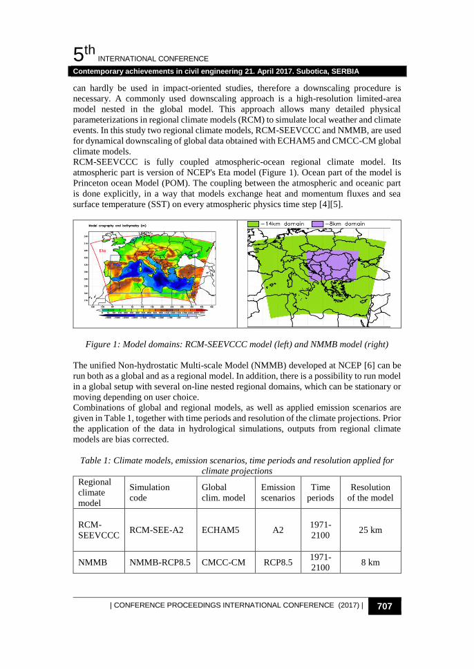
RCM-SEEVCCC is fully coupled atmospheric-ocean regional climate model. Its
atmospheric part is version of NCEP's Eta model (Figure 1). Ocean part of the model is
Princeton ocean Model (POM). The coupling between the atmospheric and oceanic part
is done explicitly, in a way that models exchange heat and momentum fluxes and sea
surface temperature (SST) on every atmospheric physics time step [4][5].
Figure 1: Model domains: RCM-SEEVCCC model (left) and NMMB model (right)
The unified Non-hydrostatic Multi-scale Model (NMMB) developed at NCEP [6] can be
run both as a global and as a regional model. In addition, there is a possibility to run model
in a global setup with several on-line nested regional domains, which can be stationary or
moving depending on user choice.
Combinations of global and regional models, as well as applied emission scenarios are
given in Table 1, together with time periods and resolution of the climate projections. Prior
the application of the data in hydrological simulations, outputs from regional climate
models are bias corrected.
Table 1: Climate models, emission scenarios, time periods and resolution applied for
climate projections
Regional
climate
model
Simulation
code
Global
clim. model
Emission
scenarios
Time
periods
Resolution
of the model
RCM-
SEEVCCC RCM-SEE-A2 ECHAM5 A2
1971-
2100 25 km
NMMB NMMB-RCP8.5 CMCC-CM RCP8.5 1971-
2100 8 km
5. МЕЂУНАРОДНА КОНФЕРЕНЦИЈА
Савремена достигнућа у грађевинарству 21. април 2017. Суботица, СРБИЈА
708 | ЗБОРНИК РАДОВА МЕЂУНАРОДНЕ КОНФЕРЕНЦИЈЕ (2017) |
HYDROLOGIC MODEL Hydrological model IHMS-HBV [7] is conceptual rainfall-
runoff model, composed of smaller number of modules for the transformation of the
rainfall to runoff. The model is widely used for the assessment of climate change impact
on the water regime in many countries [8][9]. The model functions as a set of modules
that perform interpolation of meteorological data, calculate snow accumulation and
snowmelt, calculate the actual evapotranspiration, account the soil moisture, determine the
volume of runoff and transform it to the discharge hydrograph. Temporally, IHMS-HBV
is continuous hydrologic model; spatially, semi-distributed model. The model is
horizontally distributed into subbasins, vertically to subzones with vegetation types and
position of lakes.
The input data to the model are observed daily values of precipitation, average daily air
temperature and mean monthly values of potential evapotranspiration. The air temperature
is used for the calculation of the snow accumulation and snowmelt. The values of potential
evapotranspiration are averaged monthly values that are transformed into daily values
depending of the soil moisture. The basin characteristics are presented with total area,
hypsometric curve and the distribution of the vegetation types. The model is adapted to
specific catchments through a process of calibration and it estimates a range of water
balance states in addition to the final output from the model, the river runoff.
The model for Toplica River is designed as simple single basin model with outlet at
Doljevac. Input data for the area-elevation distribution are obtained from ASTER Global
Digital Elevation Model [10], while the land cover data are used from the Global Land
Cover 2000 Project [11]. Daily input data are provided for two meteorological station:
Kuršumlija and Niš. The calibration was undertaken to satisfy best possible Nash-Sutcliffe
efficiency value also with the effort to achieve a minimum volume bias in both the
calibration period and the total observation period, in order to promote a stable model
water balance over the full simulation period (Table 2).
Table 2: Calibration and verification results
Calibration period
1996-2009
Verification period
1985-1995
calibration verification Nash-Sutcliffe
efficiency
criterion
accumulated
difference
(mm)
Nash-Sutcliffe
efficiency
criterion
accumulated
difference
(mm)
Toplica River 0.74 -1.03 0.68 -182
IHMS/HBV model simulates the discharge for the same periods as climate models in
Table 1. At the beginning of the every period one year is used for the spin-up of the model.
3. RESULTS AND DISSCUSION
CLIMATE PROJECTIONS The projections obtained with NMMB model according to RCP8.5 emission scenario,
indicate that annual temperature will increase from 2˚C to 6˚C till the end of the century,
compared to period from 1971 to 2000; for the RCM-SEEVCCC model and A2 scenario
the change is likely to be from 0.5˚C to 4˚C.
5th INTERNATIONAL CONFERENCE
Contemporary achievements in civil engineering 21. April 2017. Subotica, SERBIA
| CONFERENCE PROCEEDINGS INTERNATIONAL CONFERENCE (2017) | 709
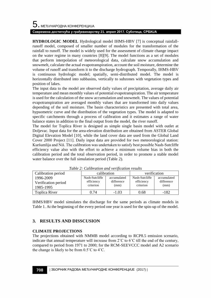
The increase of annual precipitation is expected for the period 2011-2041 for both models
and scenarios. The maximum increase of 18% is expected for A2 scenario and RCM-
SEEVCCC model, while the minimum increase of 6% is expected according to the
simulations with NMMB model. It can be also expected decrease of precipitation up to -
12% later during the century. The RCM-SEEVCCC model shows moderate decrease
compared to NMMB model (Figure 2).
Figure 2: Maps of annual temperature (˚C, left) and precipitation change (%, right)
for the period 2071–2100 with respect to 1971–2000 for RCM-SEEVCCC model
projections with ECHAM5 A2
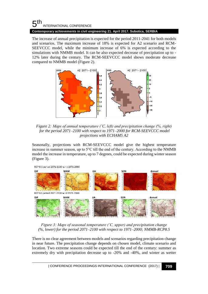
Seasonally, projections with RCM-SEEVCCC model give the highest temperature
increase in summer season, up to 5°C till the end of the century. According to the NMMB
model the increase in temperature, up to 7 degrees, could be expected during winter season
(Figure 3).
Figure 3: Maps of seasonal temperature (˚C, upper) and precipitation change
(%, lower) for the period 2071–2100 with respect to 1971–2000; NMMB-RCP8.5
There is no clear agreement between models and scenarios regarding precipitation change
in near future. The precipitation change depends on chosen model, climate scenario and
location. Two extreme seasons could be expected till the end of the century: summer as
extremely dry with precipitation decrease up to -20% and -40%, and winter as wetter
5. МЕЂУНАРОДНА КОНФЕРЕНЦИЈА
Савремена достигнућа у грађевинарству 21. април 2017. Суботица, СРБИЈА
710 | ЗБОРНИК РАДОВА МЕЂУНАРОДНЕ КОНФЕРЕНЦИЈЕ (2017) |
season with the precipitation increase up to 20% and 40%, according to RCM-SEEVCCC
and NMMB model respectively [11].
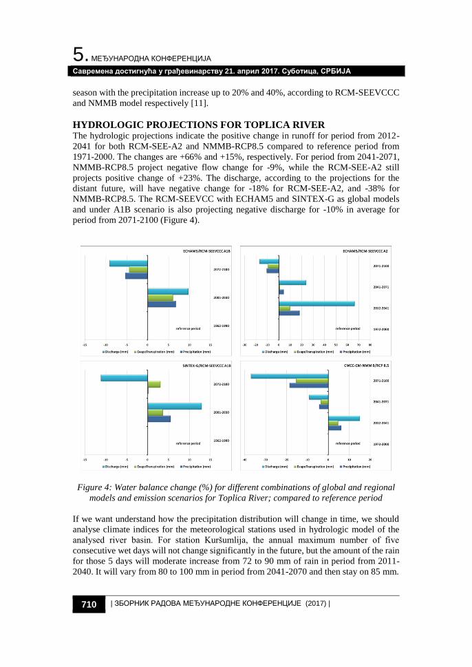
HYDROLOGIC PROJECTIONS FOR TOPLICA RIVER The hydrologic projections indicate the positive change in runoff for period from 2012-
2041 for both RCM-SEE-A2 and NMMB-RCP8.5 compared to reference period from
1971-2000. The changes are +66% and +15%, respectively. For period from 2041-2071,
NMMB-RCP8.5 project negative flow change for -9%, while the RCM-SEE-A2 still
projects positive change of +23%. The discharge, according to the projections for the
distant future, will have negative change for -18% for RCM-SEE-A2, and -38% for
NMMB-RCP8.5. The RCM-SEEVCC with ECHAM5 and SINTEX-G as global models
and under A1B scenario is also projecting negative discharge for -10% in average for
period from 2071-2100 (Figure 4).
Figure 4: Water balance change (%) for different combinations of global and regional
models and emission scenarios for Toplica River; compared to reference period
If we want understand how the precipitation distribution will change in time, we should
analyse climate indices for the meteorological stations used in hydrologic model of the
analysed river basin. For station Kuršumlija, the annual maximum number of five
consecutive wet days will not change significantly in the future, but the amount of the rain
for those 5 days will moderate increase from 72 to 90 mm of rain in period from 2011-
2040. It will vary from 80 to 100 mm in period from 2041-2070 and then stay on 85 mm.
5th INTERNATIONAL CONFERENCE
Contemporary achievements in civil engineering 21. April 2017. Subotica, SERBIA
| CONFERENCE PROCEEDINGS INTERNATIONAL CONFERENCE (2017) | 711
Also there is notable change in the sum of the daily precipitation amounts exceeding 95th
percentile. That sum is 136 mm of rainfall for present period, but will likely increase up
to 195 in the next 30 years. In the period from 2041-2070 it will vary from 158 to 200 mm,
and from 133 to 177 mm in last 30 years of this century (Figure 5).
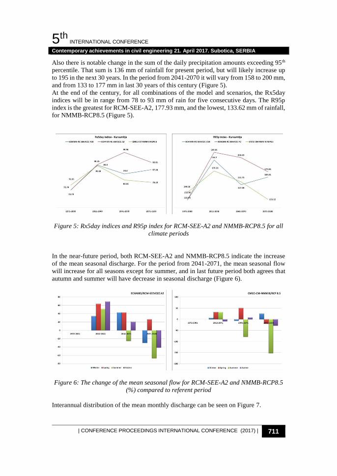
At the end of the century, for all combinations of the model and scenarios, the Rx5day
indices will be in range from 78 to 93 mm of rain for five consecutive days. The R95p
index is the greatest for RCM-SEE-A2, 177.93 mm, and the lowest, 133.62 mm of rainfall,
for NMMB-RCP8.5 (Figure 5).
Figure 5: Rx5day indices and R95p index for RCM-SEE-A2 and NMMB-RCP8.5 for all
climate periods
In the near-future period, both RCM-SEE-A2 and NMMB-RCP8.5 indicate the increase
of the mean seasonal discharge. For the period from 2041-2071, the mean seasonal flow
will increase for all seasons except for summer, and in last future period both agrees that
autumn and summer will have decrease in seasonal discharge (Figure 6).
Figure 6: The change of the mean seasonal flow for RCM-SEE-A2 and NMMB-RCP8.5
(%) compared to referent period
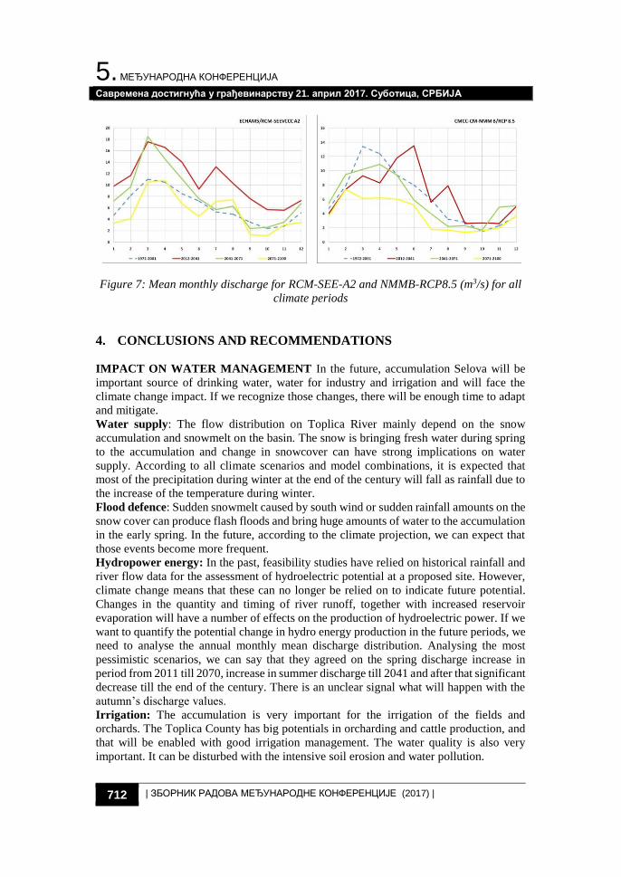
Interannual distribution of the mean monthly discharge can be seen on Figure 7.
5. МЕЂУНАРОДНА КОНФЕРЕНЦИЈА
Савремена достигнућа у грађевинарству 21. април 2017. Суботица, СРБИЈА
712 | ЗБОРНИК РАДОВА МЕЂУНАРОДНЕ КОНФЕРЕНЦИЈЕ (2017) |
Figure 7: Mean monthly discharge for RCM-SEE-A2 and NMMB-RCP8.5 (m3/s) for all
climate periods
4. CONCLUSIONS AND RECOMMENDATIONS
IMPACT ON WATER MANAGEMENT In the future, accumulation Selova will be
important source of drinking water, water for industry and irrigation and will face the
climate change impact. If we recognize those changes, there will be enough time to adapt
and mitigate.
Water supply: The flow distribution on Toplica River mainly depend on the snow
accumulation and snowmelt on the basin. The snow is bringing fresh water during spring
to the accumulation and change in snowcover can have strong implications on water
supply. According to all climate scenarios and model combinations, it is expected that
most of the precipitation during winter at the end of the century will fall as rainfall due to
the increase of the temperature during winter.
Flood defence: Sudden snowmelt caused by south wind or sudden rainfall amounts on the
snow cover can produce flash floods and bring huge amounts of water to the accumulation
in the early spring. In the future, according to the climate projection, we can expect that
those events become more frequent.
Hydropower energy: In the past, feasibility studies have relied on historical rainfall and
river flow data for the assessment of hydroelectric potential at a proposed site. However,
climate change means that these can no longer be relied on to indicate future potential.
Changes in the quantity and timing of river runoff, together with increased reservoir
evaporation will have a number of effects on the production of hydroelectric power. If we
want to quantify the potential change in hydro energy production in the future periods, we
need to analyse the annual monthly mean discharge distribution. Analysing the most
pessimistic scenarios, we can say that they agreed on the spring discharge increase in
period from 2011 till 2070, increase in summer discharge till 2041 and after that significant
decrease till the end of the century. There is an unclear signal what will happen with the
autumn’s discharge values.
Irrigation: The accumulation is very important for the irrigation of the fields and
orchards. The Toplica County has big potentials in orcharding and cattle production, and
that will be enabled with good irrigation management. The water quality is also very
important. It can be disturbed with the intensive soil erosion and water pollution.
5th INTERNATIONAL CONFERENCE
Contemporary achievements in civil engineering 21. April 2017. Subotica, SERBIA
| CONFERENCE PROCEEDINGS INTERNATIONAL CONFERENCE (2017) | 713
REFERENCES
[1] IPCC. (1996) IPCC Guidelines for National Greenhouse Gas Inventories [Internet].
http://www.ipcc-nggip.iges.or.jp/public/gl/invs1.html download 31.03.2017
[2] Trenberth, K.E., Dai, A., Rasmussen, R.M., Parsons, D.B., Trenberth, K.E., Dai, A.
et al. (2003) The Changing Character of Precipitation. Bulletin of the American
Meteorological Society, 84, 1205–17.
[3] Ivković, M., Vujadinović, M., Pejanović, G., Despotović, V. and Đurđević, V.
(2013) CLIMATE CHANGE IMPACTS ON HYDROLOGICAL REGIME AND
WATER RESOURCES MANAGEMENT IN TOPLICA RIVER BASIN.
International Conference 17-18 October: Climate Change Impacts on Water
Resources, 2013. ISBN 978-86-82565-41-3, 203-210.
[4] Djurdjevic, V. and Rajkovic, B. (2008) Verification of a coupled atmosphere-ocean
model using satellite observations over the Adriatic Sea. Annales Geophysicae,
Copernicus GmbH. 26, 1935–54.
[5] Kržič, A., Tošić, I., Djurdjević, V., Veljović, K. and Rajković, B. (2011) Changes in
climate indices for Serbia according to the SRES-A1B and SRES-A2 scenarios.
Climate Research, 49, 73–86.
[6] Janjic, Z. and Gall, R. (2012) Scientific documentation of the NCEP nonhydrostatic
multiscale model on the B grid (NMMB). Part 1 Dynamics.
[7] Bergström, S. (1992) The hbvmodel -its structure and applications. SMHI,S-601 76
NORRKÖPING, Sveden, No.4, 32.
[8] Akhtar, M., Ahmad, N. and Booij, M.J. (2009) Use of regional climate model
simulations as input for hydrological models for the Hindukush-Karakorum-
Himalaya region. Hydrol Earth Syst Sci, 13, 1075–89.
[9] Autors, T. of. (2015) The SECOND National Communication on Climate Change of
Montenegro to the United Nations Framework Convention on Climate Change
(UNFCCC). Jablan N, editor. United Nations Development Programme (UNDP) in
Montenegro, Podgorica, Montenegro.
[10] Tachikawa, T., Hato, M., Kaku, M. and Iwasaki, A. (2011) Characteristics of
ASTER GDEM version 2. 2011 IEEE International Geoscience and Remote
Sensing Symposium, IEEE. p. 3657–60.
[11] Heymann, Y., Steenmans, C., Croissille, G. and Bossard, M. (1994) CORINE Land
Cover. Technical Guide. Official Publications of the European Communities, 1–94.
УПРАВЉАЊЕ ВОДАМА РЕКЕ ТОПЛИЦА У
УСЛОВИМА МОГУЋЕ ПРОМЕНЕ КЛИМЕ
Резиме: Очекује се да ће климатске промене имати утицаја на компоненте водног
биланса речног слива а које ће се огледати кроз промену режима течења. Промене
је потребно квантификовати због њиховог утицаја на водоснадбевање,
наводњавање, коришћење хидроенергије као и на екосистем слива у целини.
Различити IPCC сценарији емисије CO2 и климатски модели формирају различите
могуће метеоролошке услове на сливу реке Топлица. Хидролошке пројекције су
5. МЕЂУНАРОДНА КОНФЕРЕНЦИЈА
Савремена достигнућа у грађевинарству 21. април 2017. Суботица, СРБИЈА
714 | ЗБОРНИК РАДОВА МЕЂУНАРОДНЕ КОНФЕРЕНЦИЈЕ (2017) |
симулиране HBV моделом са падавинама и температурама добијеним из RCM-
SEEVCCC/ ECHAM5 и RCM-SEEVCCC/SINTEX-G климатских модела по A1B
IPCC/SRES сценарију као и ECHAM5/RCM-SEEVCCC модела и А2 сценарија.
Анализиран је и утицај новог IPCC RCP8.5 сценарија коришћењем CMCC-
CM/NMMB климатских модела. У раду су приказани утицаји које би ови климатски
сценарији имали на управљање водама овог слива у будућности.
Кључне речи: климатске промене, слив, Топлица