Embed Size (px)
Citation preview


Water Resources Assessment of Dominican Republic
Executive Summary The Dominican Republic is diverse in relief and climate, which causes a scarcity of water in some areas and abundance of water in other areas of the country. Overall, the Dominican Republic has adequate water resources to meet the demand for potable water, industry, and irrigation. The largest demand for water is for irrigation. However, much water is wasted by irrigation inefficiency, and water discharged back into the streams from irrigation projects is usually high in total dissolved solids, fecal coliform, nitrates, phosphates, pesticides, and herbicides. Most of the water supply comes from surface water resources (about 67 percent), but a significant amount comes from ground water (about 33 percent). The surface water and shallow ground water aquifers are increasingly polluted with biological and agricultural wastes near and downstream of populated places. Due to the increasing migration of the population to urban centers, such as Santo Domingo and Santiago, biological contamination has been growing. Very little sewage is treated before being discharged into streams, unlined pits, and some wells. Solid waste disposal, also a problem, is usually dumped in unlined pits. In areas with very permeable limestone, these wastes are carried a long distance from the source in the underlying aquifer. Deforestation, with its devastating environmental consequences, is a large problem in the Dominican Republic. One of the major consequences of deforestation is that many of the reservoirs in the country are significantly silted. Deforestation causes water to run off of the ground surface at a faster rate, causing larger peak flows in streams, and also prevents water from infiltrating into the subsurface. The decreased amount of infiltration into the subsurface causes drier than expected soil conditions, less recharge to aquifers, and less flow from ground water aquifers to streams during the low flow season. Currently, the National Institute of Hydrological Resources (INDRHI) has the authority to control and regulate surface water and ground water and is in charge of the management and conservation of river basins. However, other government agencies also have responsibility for water resources and supply. Non-government agencies have done some excellent work in the Dominican Republic in environmental research, management, and conservation of river basins. However, overlapping responsibilities and lack of coordination between government agencies, and between non-government agencies and government agencies, has created a duplication of work and inefficient uses of the available resources. With the newly created Secretariat of Environment and Natural Resources, Law 64, hopefully a comprehensive water law will be established that sets the environmental policy of the country. This may also increase the dialog and coordination between government and non-government agencies.
i


Water Resources Assessment of Dominican Republic
Preface The Engineer's Office of U.S. Southern Command commissioned the U.S. Army Corps of Engineers District in Mobile, Alabama, and the U.S. Army Corps of Engineers, Topographic Engineering Center in Alexandria, Virginia, to conduct a water resources assessment of the Dominican Republic. This assessment has two objectives: to provide an analysis of the existing water resources and identify some opportunities available to the Government of the Dominican Republic to maximize the use of these resources; the other objective is to provide Dominican Republic and U.S. military planners with accurate information for planning various joint military training exercises and humanitarian civic assistance engineer exercises. A team consisting of the undersigned water resources specialists from the U.S. Army Corps of Engineers Mobile District and the Topographic Engineering Center conducted the water resources investigations for this report. Amy E. Harlan Hydrologist Engineer Research and Development Center Topographic Engineering Center Telephone: 703-428-7851 Facsimile: 703-428-6991 Email: [email protected]
Laura W. Roebuck Geologist and Report Manager Mobile District Telephone: 251-690-3480 Facsimile: 251-690-2674 Email: [email protected]
Alan W. Fong Hydrologist Engineer Research and Development Center Topographic Engineering Center Telephone: 703-428-6935 Facsimile: 703-428-6991 Email: [email protected]
iii


Water Resources Assessment of Dominican Republic
Contents Title Page
Executive Summary ....................................................................................................................... i Preface......................................................................................................................................... iii List of Acronyms and Abbreviations............................................................................................viii List of Place Names ..................................................................................................................... ix I. Introduction ..............................................................................................................................1
II. Country Profile ........................................................................................................................2 A. Geography.............................................................................................................................2 B. Population and Social Impacts ..............................................................................................4 C. Economy ...............................................................................................................................5 D. Flood Control and Flooding...................................................................................................6 E. Legislative Framework ..........................................................................................................6
III. Current Uses of Water Resources........................................................................................7 A. Water Supply and Distribution...............................................................................................7
1. Domestic Uses, Needs, and Sanitation..............................................................................7 a. Urban Areas ....................................................................................................................8 b. Rural Areas ...................................................................................................................10
2. Industrial and Commercial Uses and Needs ....................................................................10 3. Agricultural Uses and Needs............................................................................................11 4. Impact on Health and Consumptive Use..........................................................................12
B. Hydropower .........................................................................................................................12 C. Stream Gage Network.........................................................................................................13 D. Waterway Transportation ....................................................................................................13 E. Recreation ...........................................................................................................................13
IV. Existing Water Resources ..................................................................................................15 A. Surface Water Resources ...................................................................................................15
1. Precipitation and Climate .................................................................................................15 2. River Basins .....................................................................................................................16 3. Reservoirs, Lakes, Ponds, and Swamps..........................................................................23 4. Deforestation Effects and Other Contamination...............................................................24
B. Ground Water Resources....................................................................................................25 1. Aquifer Definitions and Characteristics.............................................................................26 2. Hydrogeology ...................................................................................................................27
a. Alluvial Aquifers (Map Unit 1)........................................................................................27 b. Limestone Aquifers (Map Unit 2)...................................................................................27 c. Sedimentary Rock Aquifers (Map Unit 3) ......................................................................28 d. Other Aquifers (Map Units 4, 5, and 6) .........................................................................28
3. Ground Water Quality.......................................................................................................28 V. Water Resources Provincial Summary...............................................................................29
A. Introduction..........................................................................................................................29 B. Water Conditions by Map Unit.............................................................................................29 C. Water Conditions by Province and District..........................................................................30
v

Water Resources Assessment of Dominican Republic
Contents Title Page
Provincia de Azua ...........................................................................................................31 Provincia de Baoruco ......................................................................................................33 Provincia de Barahona....................................................................................................34 Provincia de Dajabon ......................................................................................................36 Distrito Nacional ..............................................................................................................37 Provincia Duarte..............................................................................................................39 Provincia de Elias Pina ...................................................................................................41 Provincia de El Seibo ......................................................................................................43 Provincia Espaillat...........................................................................................................44 Provincia de Hato Mayor.................................................................................................45 Provincia de Independencia............................................................................................46 Provincia de La Altagracia ..............................................................................................47 Provincia de La Romana.................................................................................................48 Provincia de La Vega ......................................................................................................49 Provincia Maria Trinidad Sanchez ..................................................................................51 Provincia de Monsenor Nouel .........................................................................................53 Provincia de Monte Cristi ................................................................................................54 Provincia de Monte Plata ................................................................................................56 Provincia de Pedernales .................................................................................................57 Provincia de Peravia .......................................................................................................58 Provincia de Puerto Plata................................................................................................60 Provincia de Salcedo ......................................................................................................62 Provincia de Samana ......................................................................................................63 Provincia Sanchez Ramirez ............................................................................................65 Provincia de San Cristobal..............................................................................................66 Provincia de San Juan ....................................................................................................68 Provincia de San Pedro de Macoris................................................................................70 Provincia de Santiago .....................................................................................................72 Provincia de Santiago Rodriguez....................................................................................73 Provincia de Valverde .....................................................................................................74
VI. Recommendations ..............................................................................................................75 A. General................................................................................................................................75 B. National Water Resources Management and Policy...........................................................75
1. National Water Commission.............................................................................................76 2. National Water Law ..........................................................................................................76 3. Water Resources Council.................................................................................................77 4. Comprehensive Water Resources Evaluations ................................................................77 5. National Clearinghouse ....................................................................................................77 6. National and International Meetings.................................................................................77 7. Formulation of Task Forces..............................................................................................78 8. Suggested Strategy..........................................................................................................78
C. Watershed Protection and Management.............................................................................78 D. Troop Exercise Opportunities..............................................................................................79
1. Well Exercises..................................................................................................................79 2. Small Surface Impoundments ..........................................................................................79
E. Water Quality and Supply Involvement ...............................................................................79
vi

Water Resources Assessment of Dominican Republic
Contents Title Page
VII. Summary .............................................................................................................................80
Endnotes....................................................................................................................................81
Bibliography ..............................................................................................................................92 Figures Figure 1. Country Map ............................................................................................................... xiv Figure 2. Vicinity Map ...................................................................................................................2 Figure 3. Physiographic Provinces of the Dominican Republic ....................................................3 Figure 4. Hydrologic Basins and Gaging Stations ......................................................................14 Figure 5. Precipitation .................................................................................................................17 Tables Table 1. Population Distribution ....................................................................................................5 Table 2. Annual Water Demands..................................................................................................7 Table 3. Hydropower Statistics for Major Dams..........................................................................13 Appendix A. List of Officials Consulted and List of Agencies Contacted List of Officials Consulted ......................................................................................................... A-1 List of Agencies Contacted ....................................................................................................... A-4
Appendix B. Glossary Glossary ................................................................................................................................... B-1 Appendix C. Surface Water Resources and Ground Water Resources Tables Table C-1. Surface Water Resources ....................................................................................... C-1 Table C-2. Ground Water Resources .................................................................................... C-13
Figures Figure C-1. Surface Water Resources.................................................................................... C-25 Figure C-2. Ground Water Resources ................................................................................... C-27
vii

Water Resources Assessment of Dominican Republic
List of Acronyms and Abbreviations Acronyms
CDE Dominican Electric Corporation CAASD Corporation for Water Supply and Sanitation in Santo Domingo CORASSAN Corporation for Water Supply and Sanitation in Santiago CORAAMOCA Moca Sewerage System Corporation INAPA National Institute of Potable Water and Sewerage Systems INDRHI National Institute of Hydrological Resources USACE U.S. Army Corps of Engineers USAID U.S. Agency for International Development
Abbreviations As arsenic BOD biological oxygen demand CaCO3 calcium carbonate Cd cadmium Cl chloride CO2 carbon dioxide DO dissolved oxygen DDT dichlorodiphenyltrichloroethane F fluoride Fe iron gal/min gallons per minute Hg mercury km kilometers km2 square kilometers L liters m meters m3/km2/yr cubic meters per square kilometer per year m3/s cubic meters per second mg/L milligrams per liter mL milliliters Mm3 million cubic meters NTU nephelometric turbidity units MPN most probable number Na sodium PCBs polychlorinated biphenyls pH hydrogen-ion concentration SO4 sulfate TDS total dissolved solids TSS total suspended solids
viii

Water Resources Assessment of Dominican Republic
List of Place Names Place Name
Geographic Coordinates
Aguacate Reservoir .................................................................... 1829N07018W Armando Bermudez (national park)............................................ 1907N07104W Arroyo Comate............................................................................ 1843N06937W Atlantic Coastal Plain.................................................................. 1830N06925W Azua, Bani, and San Cristobal Basin (II) .................................... 1827N07023W Azua Plain................................................................................... 1830N07045W Bahia de Samana (Samana Bay) ............................................... 1910N06925W Baitoa ......................................................................................... 1943N07134W Bao ............................................................................................. 1918N07048W Bao Reservoir ............................................................................. 1918N07045W Boca de los Rios......................................................................... 1845N07102W Caribbean coastal plain ............................................................. 1840N06919W Chacuey Reservoir ..................................................................... 1937N07132W Cibao Valley (Valle del Cibao) .................................................... 1915N07015W Concepcion de la Vega............................................................... 1913N07031W Cordillera Central (mountain range) ........................................... 1845N07030W Cordillera Oriental (mountain range) .......................................... 1855N06915W Cordillera Septentrional (mountain range).................................. 1945N07115W Costa Norte Basin (VIII).............................................................. 1938N07029W Dajabon (populated place).......................................................... 1933N07142W Distrito Nacional (National District) ............................................. 1833N06950W Duarte (port) ............................................................................... 1912N06927W El Caobal .................................................................................... 1835N07010W El Corozo.................................................................................... 1841N07103W El Limon...................................................................................... 1909N07117W El Puente .................................................................................... 1841N07104W Gaging Station Near Baitoa........................................................ 1943N07134W Gaging Station Near Bao............................................................ 1918N07048W Gaging Station Near Boca de los Rios ....................................... 1845N07102W Gaging Station Near Concepcion de La Vega............................ 1913N07031W Gaging Station Near El Caobal................................................... 1835N07010W Gaging Station Near El Limon .................................................... 1909N06949W Gaging Station Near El Puente................................................... 1841N07104W Gaging Station Near Guazumal.................................................. 1856N07116W Gaging Station Near Hatillo ........................................................ 1857N07015W Gaging Station Near Hato Viejo.................................................. 1908N07037W Gaging Station Near Higuana..................................................... 1822N07016W Gaging Station Near La Antonia ................................................. 1938N07124W Gaging Station Near Mendez ..................................................... 1829N07029W Gaging Station Near Palo Verde ................................................ 1946N07133W Gaging Station Near Potrero ...................................................... 1928N07056W Gaging Station Near Puente San Rafael .................................... 1935N07104W Gaging Station Near San Cristobal............................................. 1825N07006W Gaging Station Near Santiago de los Caballeros ....................... 1927N07042W
ix

Water Resources Assessment of Dominican Republic
List of Place Names, Continued Place Name
Geographic Coordinates
Gaging Station Near Villa Riva ................................................... 1911N06955W Gaging Station Near Villa Nizao ................................................. 1801N07111W Gaging Station Near Villarpando ................................................ 1839N07102W Guazumal ................................................................................... 1856N07116W Haina .......................................................................................... 1825N06959W Hatillo.......................................................................................... 1857N07015W Hatillo Reservoir ......................................................................... 1857N07015W Hato Viejo ................................................................................... 1908N07037W Higuana ...................................................................................... 1822N07016W Higuey Basin (V)......................................................................... 1830N06838W Hoya de Enriquillo (structural basin)........................................... 1825N07126W Isabel de Torres scientific reserve .............................................. 1947N07042W Isla Cabritos (national park)........................................................ 1829N07141W Isla Saona................................................................................... 1809N06840W Jaragua (national park)............................................................... 1748N07130W Jiguey Reservoir ......................................................................... 1832N07022W Jimenoa Reservoir...................................................................... 1901N07035W Jose del Carmen Ramirez (national park) .................................. 1859N07103W La Antonia .................................................................................. 1938N07124W Lago Enriquillo (lake) .................................................................. 1831N07140W Lago Enriquillo Basin (XIII) ......................................................... 1825N07132W Laguna de Bavaro (lake) ............................................................ 1839N06823W Laguna de Rincon (lake)............................................................. 1817N07114W Laguna Limon (lake) ................................................................... 1859N06851W Laguna Oviedo (lake) ................................................................. 1745N07122W Laguna Redonda (lake) .............................................................. 1901N06857W Laguna Saladilla (lake) ............................................................... 1940N07143W Lagunas Redonda and Limon scientific reserve......................... 1900N06855W La Romana (populated place) .................................................... 1825N06858W Las Barias Reservoir .................................................................. 1822N07017W Los Haitises (national park) ........................................................ 1902N06937W Lopez-Angostura Reservoir ........................................................ 1919N07042W Maguaca Reservoir..................................................................... 1937N07131W Mendez....................................................................................... 1829N07029W Miches and Sabana de la Mar Basin (VI) ................................... 1856N06915W Monte Cristi (national park)......................................................... 1945N07143W Nagua (populated place) ............................................................ 1923N06950W Palo Verde.................................................................................. 1946N07133W Parque Nacional de Este (national park) .................................... 1820N06845W Pedro Santana............................................................................ 1906N07142W Peninsula de Samana Basin (VII)............................................... 1915N06925W Pico Duarte (mountain)............................................................... 1902N07059W Pieda Gorda Reservoir ............................................................... 1850N07029W Potrero........................................................................................ 1928N07056W Provincia de Altagracia ............................................................... 1835N06838W Provincia de Azua....................................................................... 1835N07040W Provincia de Bahoruco................................................................ 1830N07121W
x

Water Resources Assessment of Dominican Republic
List of Place Names, Continued Place Name
Geographic Coordinates
Provincia de Barahona ............................................................... 1810N07115W Provincia de Dajabon.................................................................. 1930N07135W Provincia de Duarte .................................................................... 1915N07005W Provincia de Elias Pina............................................................... 1900N07135W Provincia de El Seibo.................................................................. 1848N06903W Provincia de Espaillat ................................................................. 1930N07027W Provincia de Hato Mayor ............................................................ 1850N06920W Provincia de Independencia ....................................................... 1815N07130W Provincia de La Altagracia .......................................................... 1835N06838W Provincia de La Romana ............................................................ 1830N06858W Provincia de La Vega.................................................................. 1907N07037W Provincia de Maria Trinidad Sanchez......................................... 1930N07000W Provincia de Monsenor Noel....................................................... 1855N07025W Provincia de Monte Cristi............................................................ 1940N07125W Provincia de Monte Plata............................................................ 1850N06950W Provincia de Pedernales............................................................. 1804N07130W Provincia de Peravia................................................................... 1830N07027W Provincia de Puerto Plata ........................................................... 1945N07045W Provincia de Salcedo.................................................................. 1925N07020W Provincia de Samana.................................................................. 1915N06927W Provincia de Sanchez Ramirez................................................... 1900N07010W Provincia de San Cristobal ......................................................... 1833N07012W Provincia de San Juan................................................................ 1850N07115W Provincia de San Pedro de Macoris ........................................... 1830N06920W Provincia de Santiago................................................................. 1925N07055W Provincia de Santiago Rodriguez ............................................... 1925N07120W Provincia de Valverde................................................................. 1937N07100W Puente San Rafael...................................................................... 1935N07104W Rincon Reservoir ........................................................................ 1906N07024W Rio Amina ................................................................................... 1933N07101W Rio Artibonito .............................................................................. 1856N07153W Rio Artibonito Basin (XIV) ........................................................... 1856N07130W Rio Bao....................................................................................... 1920N07043W Rio Bajabonico............................................................................ 1953N07105W Rio Boba..................................................................................... 1928N06952W Rio Boya ..................................................................................... 1845N06948W Rio Camu.................................................................................... 1909N07006W Rio Chacuey ............................................................................... 1941N07139W Rio Chavon................................................................................. 1824N06853W Rio Cumayasa ............................................................................ 1823N06905W Rio Dajabon................................................................................ 1942N07145W Rio Dajabon Basin (XI) ............................................................... 1935N07136W Rio del Medio.............................................................................. 1843N07102W Rio Dulce .................................................................................... 1825N06857W Rio Guayubin.............................................................................. 1940N07124W Rio Haina.................................................................................... 1825N07001W Rio Isabela.................................................................................. 1831N06954W
xi

Water Resources Assessment of Dominican Republic
List of Place Names, Continued Place Name
Geographic Coordinates
Rio Jima...................................................................................... 1910N07023W Rio Jimenoa................................................................................ 1909N07039W Rio La Palma .............................................................................. 1901N07035W Rio Las Cuevas .......................................................................... 1843N07102W Rio Las Damas ........................................................................... 1823N07132W Rio Macasia................................................................................ 1856N07152W Rio Macoris................................................................................. 1826N06919W Rio Maguaca............................................................................... 1942N07131W Rio El Manguito .......................................................................... 1827N07130W Rio Mao 1935N07103W Rio Mijo....................................................................................... 1843N06953W Rio Nagua................................................................................... 1922N06950W Rio Nigua.................................................................................... 1822N07003W Rio Nizaito .................................................................................. 1800N07110W Rio Nizao .................................................................................... 1814N07011W Rio Ocoa..................................................................................... 1816N07035W Rio Ozama.................................................................................. 1828N06953W Rio Ozama Basin (III) ................................................................. 1841N06951W Rio Pedernales ........................................................................... 1802N07144W Rio San Juan .............................................................................. 1840N07104W Rio Soco ..................................................................................... 1827N06912W Rio Yabacao ............................................................................... 1834N06947W Rio Yasica................................................................................... 1942N07022W Rio Yaque del Norte ................................................................... 1951N07141W Rio Yaque del Norte Basin (X).................................................... 1923N07102W Rio Yaque del Sur....................................................................... 1817N07106W Rio Yaque del Sur Basin (XII)..................................................... 1843N07101W Rio Yuna..................................................................................... 1912N06937W Rio Yuna Basin (IX) .................................................................... 1907N07022W Rio Yuma.................................................................................... 1823N06836W Sabana de la Mar (populated place)........................................... 1904N06923W Sabana Yegua Reservoir............................................................ 1843N07103W Sabaneta Reservoir .................................................................... 1858N07118W Samana Peninsula...................................................................... 1915N06925W San Cristobal .............................................................................. 1825N07006W San Felipe de Puerto Plata......................................................... 1948N07041W San Pedro de Macoris and La Romana Basin (IV)..................... 1840N06910W Santa Barbara de Samana (port)................................................ 1913N06919W Santiago (Santiago de los Caballeros) ....................................... 1927N07042W Santo Domingo........................................................................... 1828N06954W Sierra Baoruco Basin (I) ............................................................. 1800N07130W Sierra de Bahoruco (national park)............................................. 1818N07140W Sierra de Baoruco (mountain range) .......................................... 1810N07125W Sierra de Neiba (mountain range) .............................................. 1840N07130W Tavera Reservoir ........................................................................ 1916N07042W Valdesia Reservoir...................................................................... 1823N07016W
xii

Water Resources Assessment of Dominican Republic
List of Place Names, Continued Place Name
Geographic Coordinates
Valle del Cibao (Cibao Valley) .................................................... 1915N07015W Valle de San Juan (San Juan Valley) ......................................... 1850N07120W Valle Nuevo (scientific reserve) .................................................. 1848N07042W Villa Elisa scientific reserve ........................................................ 1941N07116W Villa Nizao................................................................................... 1801N07111W Villa Riva..................................................................................... 1911N06955W Villarpando.................................................................................. 1839N07102W
Geographic coordinates for place names and primary features are in degrees and minutes of latitude and longitude. Latitude extends from 0 degrees at the Equator to 90 degrees north or south at the poles. Longitude extends from 0 degrees at the meridian established at Greenwich, England, to 180 degrees east or west established in the Pacific Ocean near the International Date Line. Geographic coordinates list latitude first for Northern (N) or Southern (S) Hemisphere and longitude second for Eastern (E) or Western (W) Hemisphere. For example:
Aguacate Reservoir......1829N07018W Geographic coordinates for Aguacate Reservoir that are given as 1829N07018W equal 18° 29' N 70° 18' W and can be written as a latitude of 18 degrees and 29 minutes north and a longitude of 70 degrees and 18 minutes west. Coordinates are approximate. Geographic coordinates are sufficiently accurate for locating features on the country-scale map. Geographic coordinates for rivers are generally at the river mouth.
xiii

Water Resources Assessment of Dominican Republic
Figure 1. Country Map
xiv

Water Resources Assessment of Dominican Republic
I. Introduction Water, possibly the world's most indispensable resource, nourishes and sustains all living things. At least 400 million people in the world live in regions with severe water shortages. By the year 2050, shortages are expected to affect 4 billion people. At least 5 million people die every year from water-related illnesses. The projected short supply of usable potable water could result in the most devastating natural disaster since history has been accurately recorded, unless something is done to stop it.1,2 Water resources are projected to be among the principal global environmental challenges of the 21st Century.
A direct relationship exists between the abundance of water, population density, and quality of life. As the world's population grows, pressure on the limited water resources grows. Unless water resources are properly managed, scarcity can be a roadblock to economic and social progress. A plentiful supply of water is one of the most important factors in the development of modern societies. The two major issues in the development of water resources are quantity and quality. Availability of water for cleansing is directly related to the control and elimination of disease. The convenience of water improves the quality of life.3 In developing countries, water use drops from 40 liters per day per person when water is supplied to the residence to 15 liters per day per person if the source is 200 meters away. If the water source is more than 1,000 meters away, water use drops to less than 7 liters per day per person.4 As well as being in abundant supply, the available water must have specific quality characteristics, such as the low concentration of total dissolved solids (TDS). The TDS concentration of water affects the domestic, industrial, commercial, and agricultural uses of water. The natural nontoxic constituents of water are not a major deterrent to domestic use until the TDS concentration exceeds 1,000 milligrams per liter. As TDS values increase over 1,000 milligrams per liter, the usefulness of water for commercial, industrial, and agricultural uses decreases. In addition to TDS concentrations, other quality factors affect water. These factors include the amount of disease-causing organisms, the presence of manufactured chemical compounds and trace metals, and certain types of natural ions that can be harmful in higher concentrations.
The purpose of this assessment is to document the overall water resources situation in the Dominican Republic. This work involves describing the existing major water resources in the country, identifying special water resources needs and opportunities, documenting ongoing and planned water resources development activities, and suggesting practicable approaches to short- and long-term water resources development. This assessment is the result of an in-country information-gathering trip and of information obtained in the United States. The scope is confined to a "professional opinion," given the size of the country and the host of technical reports available on the various water resources aspects of the Dominican Republic.
This information can be used to support current and potential future investments in managing the water resources of the country and to assist military planners during troop engineering exercises. The surface water and ground water graphics, complemented by the tables in Appendix C, should be useful to water planners as overviews of available water resources on a countrywide scale. The surface water graphic divides the country into surface water regions, based on surface water quantities available. The ground water graphic divides the country into regions with similar ground water characteristics.
In addition to assisting the military planner, this assessment can aid the host nation by highlighting its critical need areas, which supports potential water resources development, preservation, and enhancement funding programs. Highlighted problems are the lack of access to water supply by a significant part of the population, the high population density in Santo
1

Water Resources Assessment of Dominican Republic
Domingo, the lack of wastewater treatment, the devastating effects of deforestation, and the lack of hydrologic data. Watershed management plans should be enacted to control deforestation and to manage water resources.
Responsibility for overseeing the water resources of the Dominican Republic is shared by several government agencies and institutions. The U.S. Army Corps of Engineers (USACE) assessment team met and consulted with the organizations most influential in deciding priorities and setting goals for the water resources (see Appendix A). Most of these agencies conduct their missions with little or no coordination with other agencies, which creates duplication of work and inefficient use of resources.
II. Country Profile A. Geography
The Dominican Republic covers about 48,730 square kilometers, which includes land and inland water bodies (see figure 1). The country, in land area comparison, is slightly larger than twice the size of the U.S. state of New Hampshire. About 275 kilometers of the Dominican Republic borders Haiti to the west (see figure 2). The mountains and valleys of the Dominican Republic divide the country into the northern, the central, and the southwestern regions.5
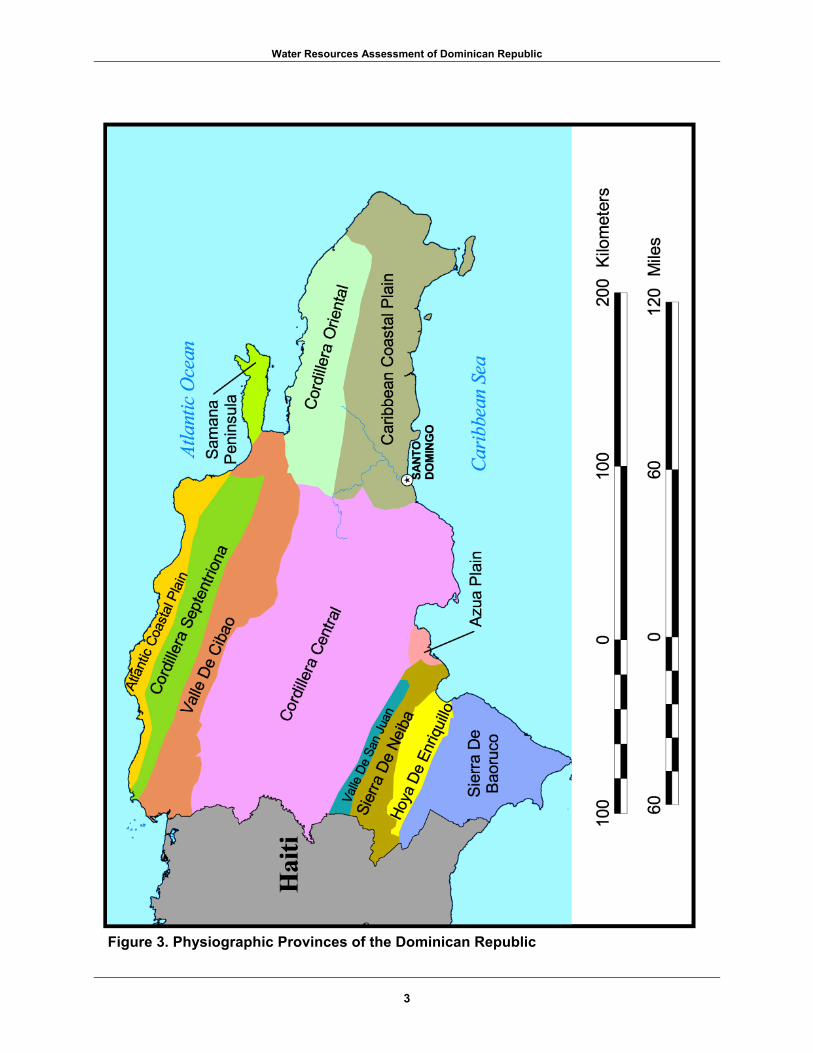
The northern region bordering the Atlantic Ocean consists of the Atlantic coastal plain, the Cordillera Septentrional (Northern Mountain Range), the Valle del Cibao (Cibao Valley), and the Samana Peninsula (see figure 3). The Atlantic coastal plain is a narrow strip that extends from the northwestern coast at Monte Cristi to Nagua, northwest of the Samana Peninsula. The Cordillera Septentrional is south of and parallel to the coastal
Figure 2. Vicinity Map
plain. Its highest peaks rise to an elevation of over 1,000 meters. The Valle del Cibao is south of the Cordillera Septentrional. It extends 240 kilometers from the northwest coast to the Bahia de Samana in the east and ranges in width from 15 to 45kilometers. The Samana Peninsula is an eastward extension of the northern region, separated from the Cordillera Septentrional by an area of swampy lowlands. The peninsula is mountainous; its highest elevations reach 600 meters.
2
Water Resources Assessment of Dominican Republic
Figure 3. Physiographic Provinces of the Dominican Republic
3

Water Resources Assessment of Dominican Republic
The central region is dominated by the Cordillera Central (Central Range). Its mountains are 2,000 meters high near the border with Haiti and reaches a height of 3,087 meters at Pico Duarte, the highest point in the country. The Cordillera Oriental (Eastern Range) is an eastern branch of the Cordillera Central. The Caribbean coastal plain is south of the Cordillera Oriental from the mouth of the Rio Haina to the extreme eastern end of the island. The Caribbean coastal plain is 10 to 40 kilometers wide and consists of a series of limestone terraces that gradually rise to a height of 100 to 120 meters at the foothills of the Cordillera Oriental. The Azua Plain is south of the Cordillera Central. The southwestern region encompasses the Sierra de Neiba, which extends 100 kilometers from the border with Haiti to the Rio Yaque del Sur. The main peaks are about 2,000 meters high, while other peaks range from 1,000 to 1,500 meters. The Hoya de Enriquillo is a structural basin south of the Sierra de Neiba that encompasses Lago Enriquillo, a major saline lake. The northeastern part of the Dominican Republic separates the two active tectonic plates: the North American plate to the north and the Caribbean plate to the south. The junction between the two plates results in a left-lateral strike-slip fault zone. Previous investigations by the U.S. Geological Survey on radiocarbon analysis of the soil horizons within the Valle del Cibao indicate three large prehistoric (pre-1492) earthquakes that resulted in significant offset along the fault zone from these events.6
B. Population and Social Impacts
The population of the Dominican Republic is increasing at a slow annual rate. In 2000, the population totaled about 8,553,744 (see table 1). The growth rate peaked during the 1950s at 6.1 percent per year. By the mid-1980s, the rate was roughly 2.5 percent annually. Presently, the population growth rate is estimated at 4.7 percent annually.7 Much of the urban growth is concentrated within Santo Domingo. Population is unevenly distributed throughout the country. About one-third of the population lives in the Distrito Nacional. About 20 percent of the population lives in the central part of the Valle del Cibao. Population growth and rural-to-urban migration strained the capacity of cities to provide housing and amenities. By the mid-1980s, an estimated housing deficit of 400,000 units existed with the greatest need in the Distrito Nacional.8 Squatter settlements grew in response to the scarcity of low-cost urban housing.
4

Water Resources Assessment of Dominican Republic
Table 1. Population Distribution
Source: Internet, http://www.one/gov.do/proyecciones.htm, Accessed 12 November 2001.
Province or Autonomous Region
(Estimated for 2000) Area (km2) Azua 243,157 2,531.77 Bahoruco 124,592 1,282.23 Barahona 179,945 1,739.38 Dajabon 78,045 1,020.73 Distrito Nacional 2,677,056 1,400.79 Duarte 318,151 1,605.35 Elias Pina 66,267 1,426.20 El Seibo 105,447 1,786.80 Espaillat 228,173 839 Hato Mayor 87,595 1,329 Independencia 41,778 2,006.44 La Altagracia 128,627 2,474.34 La Romana 213,628 653.95 La Vega 390,314 2,287 Maria Trinidad Sanchez 142,030 1,271.71 Monsenor Nouel 174,923 992 Monte Cristi 103,711 1,924.35 Monte Plata 174,126 2,633.0 Pedernales 19,698 2,074.53 Peravia 223,273 1,647.73 Puerto Plata 302,799 1,856.90 Salcedo 106,450 440.43 Samana 82,135 853.74 Sanchez Ramirez 194,282 1,196.13 San Cristobal 519,906 1,265.77 San Juan 265,562 3,569.41 San Pedro de Macoris 260,629 1,255.46 Santiago 836,614 2,839 Santiago Rodriguez 65,853 1,111.14 Valverde 198,979 823.38 Total 8,553,744 48,137.66
C. Economy
The Dominican Republic’s economy experienced dramatic growth over the last decade, even though the economy was hit hard by Hurricane Georges in 1998. Although the country has long been viewed primarily as an exporter of sugar, coffee, tobacco, meats, gold, and silver, in recent years, the service sector has overtaken agriculture and commodities as the economy’s largest employer. The strength of the service sector is due to the growth in tourism and free trade zones within the country. Services and government account for 58.7 percent of the labor force, whereas industry and agriculture account for 41.3 percent of the labor force. The country, however, suffers from marked income inequality. The poorest half of the receives less than one-fifth of the gross national product (GNP), while the richest 10 percent enjoys 40 percent of the GNP. About 25 percent of the population falls below the poverty line. The estimated gross domestic product in the Dominican Republic was $48.3 billion in 2000. In December 2000, the new Mejia administration passed broad new tax legislation, which it hoped would provide enough revenue to offset rising oil prices and to service foreign debt. Additionally, a trade deficit existed between imports and exports in 2000. Exports accounted for $5.8 billion and included sugar, coffee, cocoa, tobacco, beans, bananas, cattle, dairy products, nickel, gold, and silver primarily to the United States. Imports accounted for $9.6 billion and
5

Water Resources Assessment of Dominican Republic
included foodstuffs, petroleum, cotton, chemicals, and pharmaceuticals, also primarily from the United States.
D. Flood Control and Flooding
Flash floods occur frequently from June to October and are a constant threat to low-lying areas. The Dominican National Planning Office deals with flood control issues for the country.9 The government has established regulatory, as well as public participatory measures to address natural disasters. However, no disaster emergency fund has been established, and a plan that integrates disaster policy into the national development planning process has yet to be developed.10 On 22 September 1998, Hurricane Georges brought heavy rains to nearly 70 percent of the country. Damages to farms, roads, and buildings surpassed $1.2 billion.11 Between 20 and 25 September 1998, rainfall totaled nearly 500 milimeters.12 The effect of such a hurricane is magnified within a country with extensive deforestation. In 1998, forest cover made up 27 percent of the country.13 Roots from trees generally prevent excessive sediment erosion and runoff. Without trees, vast amounts of eroded soil are washed into lakes and rivers. This results in the silting of these water bodies, which hinders their ability to carry water away and results in additional flooding. Flooding triggers landslides, increases water and food contamination, and also destroys the physical infrastructure (roads, houses, schools, etc.) of the country.
E. Legislative Framework
The Dominican Republic lacks a comprehensive water policy. Various agencies and non-governmental organizations share the responsibility for overseeing the water resources and supplies. Deficiencies within the country’s water resources infrastructure include the lack of water quality criteria for streams, the lack of ground water contamination standards, and the lack of enforcement to treat all wastewater discharge or effluent. A few government agencies are involved with limited management of water resources.14 The National Institute of Hydrological Resources (INDRHI) and other agencies have been given specific mandates for managing hydrographic regions. Although INDRHI manages irrigation systems throughout the country, it is gradually delegating some of this responsibility to the Juntas (local governing boards). The National Institute for Potable Water and Sewage Systems (INAPA) provides sanitary sewer service for rural communities. The newly created Environment and Natural Resources Institute manages watersheds, and is developing a national environmental action plan. The creation of the Secretariat of the Environment and Natural Resources in August 2000 (as Law 64) integrated the Secretariat and other public institutions with environmental functions. It also established a series of environmental policies to which the private sector and current and successive governments must adapt. Law 64 created a judicial system for the defense and protection of the environment, which is housed administratively in the Office of the Attorney General. This law seeks to identify and hold accountable the parties responsible for damage to the environment. Non-governmental organizations are an existing institutional resource that can carry out actions beneficial to the sustainability of water resources in the Dominican Republic.15 These organizations also contribute to public awareness and academic research concerning these water resources. The Junta de Ocoa is developing 18 small irrigation projects with plans for
6
Water Resources Assessment of Dominican Republic
17 more. The Junta Agroempresarial Dominicana Inc. is improving water quality of the Rio Ozama. The Pedro Henriquez Urena University is also diagnosing water pollution of the Rio Ozama and the Rio Yaque del Norte and assisting the INDRHI with the management of watersheds.
III. Current Uses of Water Resources
A. Water Supply and Distribution
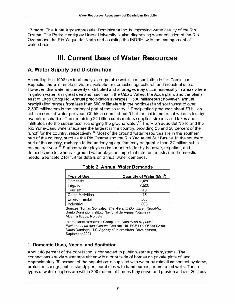
According to a 1998 sectoral analysis on potable water and sanitation in the Dominican Republic, there is ample of water available for domestic, agricultural, and industrial uses. However, this water is unevenly distributed and shortages may occur, especially in areas where irrigation water is in great demand, such as in the Cibao Valley, the Azua plain, and the plains east of Lago Enriquillo. Annual precipitation averages 1,500 millimeters; however, annual precipitation ranges from less than 500 millimeters in the northwest and southwest to over 2,500 millimeters in the northeast part of the country.16 Precipitation produces about 73 billion cubic meters of water per year. Of this amount, about 51 billion cubic meters of water is lost by evapotranspiration. The remaining 22 billion cubic meters supplies streams and lakes and infiltrates into the subsurface, recharging the ground water.17 The Rio Yaque del Norte and the Rio Yuna-Canu watersheds are the largest in the country, providing 25 and 20 percent of the runoff for the country, respectively.18 Most of the ground water resources are in the southern part of the country, such as the Rio Ozama and the Rio Yaque del Sur Basins. In the southern part of the country, recharge to the underlying aquifers may be greater than 2.2 billion cubic meters per year.19 Surface water plays an important role for hydropower, irrigation, and domestic needs, whereas ground water plays an important role for industrial and domestic needs. See table 2 for further details on annual water demands.
Table 2. Annual Water Demands
Type of Use
Quantity of Water (Mm3) Domestic 1,450 Irrigation 7,500 Tourism 40 Cattle Activities 45 Environmental 500 Industrial 305
Sources: Tomas Gonzalez, The Water in Dominican Republic, Santo Domingo: Instituto Nacional de Aguas Potables y Alcantarillados, No date. International Resources Group, Ltd. Dominican Republic Environmental Assessment. Contract No. PCE-I-00-96-00002-00, Santo Domingo: U.S. Agency of International Development, September 2001.
1. Domestic Uses, Needs, and Sanitation About 48 percent of the population is connected to public water supply systems. The connections are via water taps either within or outside of homes on private plots of land. Approximately 39 percent of the population is supplied with water by rainfall catchment systems, protected springs, public standpipes, boreholes with hand pumps, or protected wells. These types of water supplies are within 200 meters of homes they serve and provide at least 20 liters
7

Water Resources Assessment of Dominican Republic
of safe water per person, per day. Close to 12 percent of the total population does not have potable water supply service and may be using untreated water from rivers, springs, rainwater catchment systems, and wells. Some of the population may travel greater than 200 meters to public water supplies. Water quality standards are less strict than those of the World Health Organization.20 Identified problems which occur in the domestic water supply sector include:
• Inadequate or poor legal and institutional framework; • Inadequate operation and maintenance of equipment, which causes intermittent water
service; • Lack of trained professionals and technicians; • Deterioration in water quality resulting from over pumping, pollution from fertilizers,
human and animal wastes, and other pollutants; • Insufficient knowledge of water resources; • Deficiency of water resources in some areas, which requires the transfer of water from
one basin to another; • Inadequate cost-recovery framework; • Lack of definite government policy and lack of planning; • Funding limitations; and, • Logistical problems.
Many of the same problems that are identified for the domestic water supply sector also apply to the sanitary sector. This affects the sanitation of drinking water because many water sources are biologically contaminated by human and animal wastes. On the national level, about 20 percent of the population is connected to a public sewerage system, and about 70 percent of the population uses public or private septic systems or latrines, 21 which are used by most of the population. Nationwide, only a small amount of wastewater collected by sewers is treated. The potable water supply and sewer collection and disposal services fall under the responsibility of the National Institute of Potable Water Supply and Sewerage Service (INAPA). Exceptions are urban areas such as Santo Domingo, in which the Corporation for Water Supply and Sanitation in Santo Domingo (CAASD) provides these services. In Santiago, the Corporation for Water Supply and Sanitation in Santiago (CORASSAN) provides these services. Other exceptions are in La Romana, where La Romana Sewerage System Corporation is responsible for sewerage services, and in the Provincia de Espaillat, where Moca Sewerage System Corporation (CORAAMOCA) is responsible for the sewerage service. The quality of water in the Dominican Republic is declining. The coverage and supply of water and sanitary services have not met the demand or the expectations of the public (for good service and access to these services). Most water supply and sanitation services are funded and run by the Government. From 1996 to 1998, the annual investment for the potable water and sanitation sector was only 7.9 percent of the social expenses for the country.22 Except for CORASSAN, all government institutions involved in the sanitation and water supply services operate at a deficit. a. Urban Areas In urban areas, 62 percent of the people have a connection to a public water system and 35 percent of the people have access to a public water supply point within 200 meters of their home. 23 Even though there have been great efforts to supply the public with drinking water, nearly 850,000 people in cities are still without connection to water supplies.24 In addition, only 31 percent of the population has access to a public sewerage system. 25 These deficiencies are largely due to demographic changes. In the last 20 years, most of the Dominican Republic
8

Water Resources Assessment of Dominican Republic
population has migrated from rural areas to over 65 percent residing in cities. 26 With this rapid migration, the water and sewerage infrastructure has not correspondingly increased in size. Perhaps the city with the most acute water and sewerage system problems is the capital, Santo Domingo. The city contains about one-half of the country's urban population and almost one-third of the total national population. Immigration to this city is exceeding the water and sewerage capacity by ten-fold.27,28 There, CAASD is responsible for supplying the Santo Domingo with a potable water supply and a sanitary sewerage system. About 67 percent of the water supply for Santo Domingo comes from surface water, and 33 percent comes from ground water.29 The surface water supply comes from many sources, such as the Valdesia Reservoir (about 6 cubic meters per second) on the Rio Nizao, the Rio Haina (about 4 cubic meters per second), Rio Isabela (about 0.5 cubic meter per second), and from various small streams.30 Several well fields also supply water to the city. Plans exist to create another well field with 25 wells that will each produce 1 cubic meter per second of water for the city.31 Also planned is a diversion from the Rio Ozama that will divert about 4 cubic meters per second for potable water supply.32 This water is treated and placed in the water supply system. About 40 to 60 percent of the water produced is lost; about 30 percent of this loss is probably due to household and business waste. 33 In an effort to better monitor the distribution system, the city is installing water meters to determine the quantities that are being dispensed and how much of these quantities are reaching their destinations. Current estimations show 20 to 30 percent is lost from the distribution system.34 Typically, water is available for 18 hours per day in Santo Domingo.35 Sewerage systems in Santo Domingo are very poor; only 27 percent of the population has access to service.36 The rest of the population uses septic systems, latrines, or no form of managed waste disposal. The city has 14 waste treatment facilities, but none are working properly due to lack of finances, untrained personnel, and lack of demand from the public or from politicians for improvement.37 The major concerns are the marginal districts of the city such as Gualey, Guachupita, Los Guandules, 24 de Abril, Simon Bolivar, Capotillo, Cristo Rey, and Los Alcarrizos. These districts are sites of large, dense populations of poor urban dwellers, who mostly live in one-room houses. Sewage disposal is usually in open drains or latrines. In some places, the latrines are bottomless and perched over streams. Hotels have been known to inject wastewater into wells, contaminating the ground water aquifers. Overflowing sewage drains, cross contamination with potable water supplies, and the storm drainage system are other major concerns in Santo Domingo. The storm drainage system does not have the capacity to carry water from storms and often becomes clogged with garbage and other debris. Rainfall that enters the storm drainage system is often contaminated with sediment, heavy metals, bacteria, oil, grease, rubber, organic matter, and other pollutants from industries and households. Wastewater from the waste treatment facilities, households, and the storm drainage system is being discharged into the ocean, the Rio Ozama and the Rio Isabela with little to no treatment. This water has high amounts of fecal coliform, nitrates, phosphates, and other contaminants. About 15 percent of the population of the Dominican Republic lives in Santiago, in the north-central part of the country.38 CORAASAN is responsible for supplying the city with water and a sanitary sewerage system. An estimated 44 percent of the water in the water supply system cannot be accounted for. Of that amount, 38 percent is physically lost from the system.39 Also, 77 percent of homes have water meters to monitor use and to charge accordingly. Perhaps this is the reason that CORAASAN is the only government agency in the water supply and sanitation sector that is not operating with a deficit. In Santiago, about 75 percent of the population is connected to a public sewerage system.40
9

Water Resources Assessment of Dominican Republic
INAPA supplies smaller urban areas with potable water and sanitary sewerage service. About 140 water purification plants (54 rapid filtration and 86 slow filtration) exist in the Dominican Republic; many more are under construction to supply cities and towns.41 However, many of the smaller urban areas rely on private wells, bottled water, water delivery trucks, and sometimes rainfall catchments to supply potable water needs, and many smaller urban areas have no sanitary sewerage service. Urban centers are also dealing with inadequate solid waste disposal, which contaminates the surface water. Private companies handle solid waste removal. However, adequate waste disposal service to all urban centers is lacking. Local governments and health ministries in urban centers, such as Santo Domingo, have programs to encourage people to dispose of solid wastes to prevent or reduce the incidence of diseases and to prevent water contamination. About 98 percent of all solid waste nationwide is deposited in open, unlined pits.42 When it rains, the water percolates through the waste and picks up or dissolves organic matter, nitrates, chlorides, sulfates, oil, and other wastes. If the underlying rock is very permeable, the water will percolate down through the bedrock and contaminate the subsurface aquifer. Depending on how permeable the bedrock is, the contaminants can spread much farther than the extent of a pit. The slope of the water table generally mirrors the elevation of the ground surface. Therefore, the contaminants will probably flow down slope from a pit. This is a large problem in the southeastern coastal areas, where the underlying bedrock is very permeable limestone and the ground water table is very shallow. b. Rural Areas In rural areas, about 25 percent of the population is connected to a public water supply system. However, about 48 percent of the population has access to a public water supply, at less than 200 meters from the user's home. This public water supply may be a rainwater collection point, a public standpipe, borehole with a hand pump, or a protected well. Other people may use untreated water from streams, ponds, rooftop catchments, and in some places wells, or may travel more than 200 meters for water.43 Water treatment usually only consists of chlorination. Due to the low population density in rural areas, the cost of providing potable water service is usually much greater than in urban areas, and since incomes in many rural areas are less, people may find it hard to afford high-quality service.
2. Industrial and Commercial Uses and Needs Traditionally, the agricultural industry has employed the most people in the Dominican Republic. While this sector remains very important for domestic consumption and for export, the service industry is now the leading employer, mainly due to free-trade zones and tourism. Free-trade zones have also promoted the growth of industries. These zones are areas where imports from other countries can be sold without any import duties, trade quotas, or other restrictions, and goods from companies in the Dominican Republic can be sold to the other countries without restrictions (mainly the United States). In 1999, 32.2 percent of the gross domestic product was generated from the industry sector, and the current industrial demand for water is 40 million cubic meters per year. About 70 percent of the 7,000 registered industries and commercial businesses are in Santo Domingo, which has created some water quality problems.44 An estimated 90 percent of the industries in the country discharge wastewater to sewers or water bodies without any treatment.45 For example, a 1993 study found that the Rio Ozama, which flows through Santo Domingo, contained elevated levels of chloride, lead, iron, and nickel, due to industrial discharges.46
10

Water Resources Assessment of Dominican Republic
3. Agricultural Uses and Needs Irrigation is very important in the Dominican Republic because of the seasonal and geographical variations in rainfall. One of the most important areas for crop growth, the Cibao Valley, in the Yaque del Norte basin, is one of the driest areas in the country. Crops need irrigation because the rainfall generally ranges from 500 millimeters per year in the western part of the valley to 1,000 millimeters per year in the eastern part.47 Other areas requiring intense irrigation are in the Rio Yuna Basin and a broad area that stretches from the border with Haiti in Lago Enriquillo Basin through the middle to lower reaches of the Rio Yaque del Sur Basin, which includes the Azua, Bani, and San Cristobal Basin. The Dominican Republic has the second largest irrigated area among Caribbean and Central American countries after Cuba. In 2000, about 275,000 hectares of land were irrigated and another 319,302 hectares could be developed for irrigation.48 About 85 percent of water demand in the country is for irrigation water.49 However, current irrigation systems are very inefficient, and only about 18 to 20 percent of the irrigation water is beneficially used to grow crops.50 This inefficiency is due to several factors: canal infrastructure and its state of repair, high evaporation rates, the methods used for applying water to crops, the management of the canal system, and the education or skill of the farmers applying the water. The canal infrastructure, its state of repair, and the methods used for applying water to crops are very important to water efficiency. For instance, some canals are unlined and much of the water leaks into the subsurface. Other problems include drainage problems, neglect of canals, and in some areas, the chaotic construction by farmers of feeder canals on the main canals. The methods used to apply irrigation water are also very inefficient. Most farmers in the country use furrow or flood irrigation methods. The furrow method has an unlined furrow or small ditch constructed in between rows of crops. If the soil is not the proper type, much of the water will be absorbed before reaching the end of the row. This method can cause the buildup of salts in the soil. Flood irrigation occurs when the entire field is flooded. This method usually causes runoff and has the potential to leach important nutrients from the soil. Generally, more efficient methods such as drip irrigation are only used in scientific or specially funded projects. Farmers often over-water their fields. For farmers that have little experience with irrigation, the overuse of water can lead to the salinization or leaching of soils, increasing runoff from fields, and the raising of the water table. As soils become more saline, the productivity of the land decreases and can become useless. In the Rio Yaque del Norte Basin, a total area of 102,609 hectares is irrigated, and 48 percent of this land is slightly to very strongly saline.51 Much of the land in the drier, more arid lower basin is slightly to very strongly saline, while much of the irrigated land in the upper basin near Santiago is generally not saline. Other areas that have experienced salinity problems are the Azua Plain, the plain between Lago Enriquillo and Laguna de Rincon, and areas around Lago Enriquillo. Poor drainage and the reuse of irrigation water, which increases the dissolved salt content of the water, can also cause salinization of soils. Reuse of irrigation water also causes the water to contain higher levels of pesticides, fertilizers, and other nutrients. Leaching of nutrients from soils usually occurs with flood irrigation, where the nutrients are flushed out of the soil because of excessive water use. This is good in some places with a buildup of soluble salts; however, when nutrients are flushed out of the soil, more fertilizers need to be applied to the soil to maintain productivity. Due to the increase in fertilizers, the amount of nitrates and phosphates in the surface water runoff increases and contaminates streams. Overuse of irrigation water also raises the water table,
11
Water Resources Assessment of Dominican Republic
causing the unconfined aquifer to be contaminated with biological and chemical wastes (pesticides). Significant improvements have been made in the efficiency of canal systems due to local associations called the Junta de Regentes (Board of Regents). These associations are elected. The election process for each association begins with a group of 10 to 15 farmers that is served by a common outlet.52 In general, when under governmental control, only 15 percent of the fees for water supply were collected; these associations generally collect 60 to 85 percent of the fees.53 Under the management of the Junta de Regentes, and their success in collecting fees, the canals are generally better maintained, and water loss prevention is promoted to the farmers. Some Junta de Regentes are also able to buy modern water management equipment and to offer scholarships for members to study water management technology.
4. Impact on Health and Consumptive Use Even though the Dominican Republic has an abundance of natural resources, a large labor force, a favorable geographical location, and a growing economy, it has some of the worst health conditions in Central America. For instance, 56 out of every 1,000 children (live births) die before the age of five (1999 estimate).54 This mortality rate is due to poor prenatal care and the lack of vaccinations for preventable illnesses in children. The availability and quality of drinking water directly affects the health of a population and the quality of life. Due to inadequate sewer and wastewater treatment facilities, deficiencies in potable water supplies, lack of quality controls, and water source protection, several water-transmitted diseases are common, such as acute diarrhea, typhoid fever, hepatitis, and paratyphoid fever. Due to the high incidence of water-transmitted diseases, a large part of the urban population has begun to use bottled water. In 1995 an estimated 40 percent of the urban population used bottled water, even though the cost is much greater than the water supplied through the city water systems.55 B. Hydropower
The Dominican Electric Corporation (Corporacion Dominicana de Electricidad (CDE)) is responsible for the electricity production in the Dominican Republic. Hydroelectricity supplies the country with 27.62 percent of its electricity demands. See table 3 for further details. The Dominican Republic contains an extensive network of streams and valleys that would make ideal locations for dams for hydroelectric production. In fact, many dams and reservoirs have been built or are in the planning stage to increase electricity production. This is necessary because other sources of energy, such as fossil fuel resources, are lacking and must be imported. Two of the largest threats to the current production of hydroelectric power are deforestation and the destruction of watersheds, which causes massive erosion to fill reservoirs and rapidly wears down turbines and other machine parts.
12

Water Resources Assessment of Dominican Republic
Table 3. Hydropower Statistics for Major Dams
Dam Name Stream
Dam Height
(m) Dam Type
Reservoir Capacity (MCM)
Installed Capacity
(MW)
Power Generation (GW-h/yr)
Taveras Rio Yaque del Norte
80.0 Earthen 137.10 96.0 220
Lopez-Angostura Rio Bao 20.0 Earthen 4.40 18.9 120
Jimenoa Rio Jimenoa 14.5 Gravity 0.03 8.6 40
Moncion Rio Mao 120.0 Rock 369.40 45.0 158
Contraembalse Moncion
Rio Mao 19.0 Reinforced Concrete
7.60 3.2 15
Hatillo Rio Yuna 50.0 Earthen 375.30 8.0 50
Rincon Rio Jima 54.0 Gravity 60.10 10.1 30
Rio Blanco Rio Blanco 43.0 Gravity 1.10 25.0 108
Sabana Yegua Rio Yaque del Sur 76.0 Earthen 422.30 12.5 30
Sabaneta Rio San Juan 70.0 Earthen 63.10 6.4 25
Las Damas Rio Las Damas 15.0 Gravity 0.04 7.5 25
Jiguey Rio Nizao 110.0 Arc 167.20 98.0 202
Aguacate Rio Nizao 48.0 Gravity 4.30 52.0 208 Valdesia Rio Nizao 78.0 Buttress 187.00 54.0 80 Source: Corporacion Dominicana de Electricidad, Internet, http://www.cde.gov.do, Accessed August 2001.
C. Stream Gage Network
By 1967, 90 stream gaging stations had been established; however, it is unclear how many of these stations are still in operation today. Of this total number, 30 stations are automatic recording stations and the rest are manual stations that must be read.56 Historically, technicians recorded flow and turbidity measurements twice a day. However, due to a lack of funding and personnel, many historical records are discontinuous and may have been read wrong. Currently, some of the stream gaging stations may be buried with silt and poorly maintained, making it difficult to take measurements. See figure 4 for further details on the hydrologic basins and stream gaging stations. D. Waterway Transportation
Most of the rivers in the Dominican Republic are not navigable; however, some rivers are navigable for short distances. The Rio Ozama is navigable for a short distance, and can accommodate large cruise ships and commercial cargos. Other ports that accommodate tourist ships and commercial cargoes are San Felipe de Puerto Plata, Santa Barbara de Samana, Duarte, and La Romana. A port at Haina, west of Santo Domingo, handles a large part of the commercial and industrial cargo for the country. E. Recreation
About 14 percent of the surface area of the Dominican Republic is either a national park, or a scientific reserve.57 This percentage may be slightly lower due to the Dominican Government allowing the people to settle on land in the Valle Nuevo Scientific Reserve. Some of the major
13

Water Resources Assessment of Dominican Republic
Figure 4. Hydrologic Basins and Gaging Stations
14

Water Resources Assessment of Dominican Republic
national parks are Isla Cabritos, Sierra de Bahoruco, Jaragua, Monte Cristi, Armando Bermudez, Jose del Carmen Ramirez, Los Haitises, and the Parque Nacional de Este. Major scientific reserves are the Villa Elisa, Isabel de Torres, Ebano Verde (generally south west of Concepcion de La Vega), Laguna de Rincon, and the Lagunas Redonda and Limon Scientific Reserve. Even though there are a large number of national parks, the infrastructure for maintaining the parks is rudimentary. Visitors or tourists must not expect any services and must carry their own water and other supplies. However, these parks display some spectacular scenery, from semiarid deserts to high mountains that have tropical forests on their slopes. Two parks, the Armando Bermudez and the Jose del Carmen Ramirez National Parks, are located in the upper watershed of the Cordillera Central, a huge mountain chain in central Dominican Republic. These parks, which contain the watersheds for the Rio Yaque del Norte, the Rio Yaque del Sur, and the Rio Yuna, are serving an important function for the country because they have been largely reforested. As a result, erosion and surface water runoff are being controlled, and the spread of biological and chemical contamination from household and agricultural wastes is decreasing. Most of the tourism growth has been due to the beaches. Between 1994 and 1998, the hotel, bar, and restaurant community grew about 13 percent annually.58 This increase has been good for the economy, but has increased demands for water and sewerage services. Many resorts have their own water purification and sewerage systems. However, some of these hotels are injecting wastes into existing wells without providing treatment, thus further contaminating the aquifer.
IV. Existing Water Resources A. Surface Water Resources
1. Precipitation and Climate The climate can be generally characterized as tropical. In general, the wet, humid season occurs from April to October and the dry season occurs from November to March. In some parts of the interior of the country, there are two wet seasons, one in May or June and the other in September or October. On the southern coastal plain, the wet season is from August to October. Another notable exception is San Felipe de Puerto Plata, where the rainy months are from October to May. Due to the influence of topography and trade winds, parts of the Dominican Republic are considered arid and other parts are considered humid. The most arid parts of the country are in the northwest and the southwest. In the northwest, the lower part of the Rio Yaque del Norte river basin is arid. In the southwest, the southern part of the Sierra Baoruco Basin is arid, and an area that stretches roughly east-west from Lago Enriquillo to the Rio Ocoa is arid. To a large extent, precipitation is influenced by four major mountain ranges that cause the average annual rainfall to vary from less than 508 millimeters to greater than 2,540 millimeters.59 These mountain ranges generally extend in a northwest to southeast direction. Northeasterly (January) to east (July) trade winds bring moisture to the northern slopes of these mountains throughout the year, and less precipitation to the southern slopes and interior valleys in winter. However, some of the southern mountain slopes in the southern part of the country receive large amounts of precipitation. Precipitation amounts significantly depend on elevation; higher elevations receive more precipitation than lower elevations. Catastrophic storms, such as tropical storms and hurricanes have frequently devastated the country. Tropical storms generally have wind speeds less than 122 kilometers per hour, and
15

Water Resources Assessment of Dominican Republic
deposit large amounts of rain on the island. These storms can occur in any month; however, the largest number of storms occur in September. On average, the Dominican Republic has 8 tropical storms per year.60 Hurricanes, storms that have wind speeds greater than 122 kilometers per hour, generally occur between June and November. The storms affect the entire island, but generally the most destruction occurs on the southern coast where the hurricanes are more likely to come ashore. Hurricanes have damaging winds, which have been recorded as high as 244 kilometers per hour and cause tidal waves that have been recorded as high as 5 meters above mean sea level. These storms also deluge the country with huge amounts of rain, which may exceed 750 millimeters in a 24-hour period.61 This large volume of water causes wide-spread flooding, erosion, landslides, and mudslides. On average, a hurricane hits the country once every 2 years.62
The average annual temperature generally ranges from 24 to 27 degrees Centigrade (75 to 80 degrees Fahrenheit), with August the hottest month and January the coolest month. Temperatures have very little variation, with the monthly average temperatures varying from the average annual temperature by 2 degrees Centigrade (6 degrees Fahrenheit).63 Exceptions are in protected valleys where high temperatures of 40 degrees Centigrade (104 degrees Fahrenheit) are common and in the highest mountains where lows near 0 degrees Centigrade (32 degrees Fahrenheit) are common.64
2. River Basins The country can be divided into 14 hydrological basins that vary in topography and surface water resources. All surface water in streams is fresh, except when influenced by tides. These streams generally drain from the four major mountain ranges: Cordillera Central, Sierra de Baoruco, Cordillera Septentrional, and Sierra de Neiba. Due to deforestation, streams draining these mountains are generally flashy, meaning that they rapidly rise in response to rainfall until they reach their peak flow, and then quickly drop back to their original flow patterns. This rapid response to rainfall causes erosion and short duration floods. It also causes drier soil conditions than would normally be expected, because precipitation runs off and does not have a chance to infiltrate into the subsurface. This may also cause sediment to be deposited in the lower reaches of the river, building up the riverbed and increasing the intensity of flooding. Ponds and lakes are usually found near the coast and can range from fresh to saline. Mangrove swamps and marshes are also along the coast and usually contain brackish to saline water. However, fresh surface water may exist where streams enter these areas. In general, these streams, lakes, marshes, and mangrove swamps provide an abundant supply of surface water.
See figure 5 for further details on precipitation, and see table C-1 and figure C-1 for further details on surface water resources.
The Sierra Baoruco Basin (I) is in the most southwestern part of the country. The northern part of this basin contains the mountain range, Sierra de Baoruco. These mountains generally extend northwest to northeast, and local relief is generally greater than 610 meters. Many peaks in this mountain range are over 1,372 meters. Slopes on the southern side of these mountains generally range from 45 to 75 percent. South of the Sierra de Baoruco, the topography becomes a flat, relatively featureless plain, with local relief generally less than 152 meters and slopes of less than 10 percent.65 Topography, precipitation, and stream characteristics vary greatly in the Sierra Baoruco Basin. In the Sierra de Baoruco, annual precipitation is in excess of 2,000 millimeters, but in the southern plains the annual precipitation drops to about 750 millimeters.66 Streams in the Sierra de Baoruco are generally youthful, with steep gradients and riverbanks.
16

Water Resources Assessment of Dominican Republic
Figure 5. Precipitation Source: Gustavo Antonini, et al., The Dominican Republic: A Country Environmental Profile, McLean, Virginia: JRB Associates, July 1981, p. 12.
17

Water Resources Assessment of Dominican Republic
Streams in these mountains rise rapidly in response to precipitation. These streams may go dry during the low flow period. Streams that flow east from the mountains may reach the Caribbean Sea; however, streams that flow to the south quickly disappear by evaporation and by being absorbed by the underlying permeable limestone. The only perennial streams in this basin are the Rio Nizaito, which contains very small to small quantities of fresh water, and Rio Pedernales, which contains very small quantities of fresh water. Enormous quantities of saline water are available from Laguna Oviedo and from numerous elongated small ponds on the southernmost tip of the island. Brackish to saline water may be found in the mangrove swamp to the northeast of Laguna Oviedo and near the elongated ponds on the southern coast. The Azua, Bani, and San Cristobal Basin (II) is in the south just east of Santo Domingo, and west of the Rio Yaque del Sur. The northern part of the basin is in the Cordillera Central. Local relief is generally greater than 610 meters and generally has slopes of greater than 35 percent. Toward the coast, the topography becomes hilly and levels out to coastal plains; the local relief is less than 152 meters and slopes are generally less than 10 percent.67 Annual precipitation is highest (2,250 millimeters) in the upper elevations and decreases progressively (750 millimeters) toward the coast and the western part of the basin.68 Streams in this basin, especially in their upper courses, tend to rise rapidly after heavy rainfall and then quickly return to their original flow patterns. Very large quantities of fresh water are available from the Aguacate, Las Barias, Jiguey, and Valdesia Reservoirs, which are located on the Rio Nizao. However, these reservoirs are significantly reduced in capacity because of the enormous amount of sediment that is carried by the Rio Nizao. The largest reservoir, Valdesia Reservoir, has lost 26.1 percent of its capacity from sedimentation.69 About 6.3 cubic meters per second is diverted from Valdesia Reservoir by a canal for the potable water supply in Santo Domingo.70 The largest stream in this basin is the Rio Nizao, which has small to moderate quantities of fresh water perennially available. However, there is very little discharge of the Rio Nizao due to diversions for irrigation. The Rio Haina has small to moderate quantities of fresh water perennially available. About 0.63 cubic meters per second is diverted from the Rio Haina to supply Santo Domingo.71 This water is biologically contaminated from cattle ranching directly north of the intake point. Very small to small quantities of fresh water are perennially available from the Rio Ocoa and the Rio Nigua. Currently, the flow in the Rio Nigua may be less than reflected in table C-1 due to plans to recharge the alluvial ground water aquifer with water from the river. The rest of the basin contains intermittent streams, and near the coast there are numerous canals used for irrigation. The intermittent streams may contain meager to moderate quantities of fresh water. In the western part of the basin, the Azua plain, a large amount of land has been rendered useless by the salinization of soils from poor irrigation practices. Santo Domingo is located the Rio Ozama Basin (III). The northern boundary of this basin is in the Cordillera Oriental, a low mountain range. The local relief in this mountain range is between 152 and 610 meters, and most slopes are between 35 and 45 percent. This mountain range quickly drops down to rolling hills, dissected by streams, and then levels out to a flat plain near the coast. The local relief in the hills and plains are generally less than 152 meters, and slopes are generally less than 10 percent.72 Annual precipitation generally increases from 1,400 millimeters in the southeast part of this basin to 2,250 millimeters in the Northwest part of this basin.73 The Rio Ozama is the major stream in this basin, and has moderate quantities of fresh water perennially available. This stream flows through Santo Domingo. Due to household and sewage effluents, this stream is heavily contaminated with biological waste. Two important tributaries to the Rio Ozama are the Rio Yabacao and the Rio Isabela, which contain small to moderate quantities of water. These streams have well developed stream valleys and are dentritic in nature. Smaller tributaries to these streams, such as the Arroyo Comate, the Rio Boya, and the Rio Mijo, probably have very small to small quantities perennially available. The
18

Water Resources Assessment of Dominican Republic
rest of the basin contains intermittent streams, which contain meager to moderate quantities of fresh water. In a small part of the northern part of the basin, fresh water is scarce or lacking; any surface water is quickly channeled or absorbed into the underlying limestone aquifer. The San Pedro de Macoris and La Romana Basin (IV) is in the south, east of Santo Domingo, on the Caribbean Sea. Most of this basin is coastal plains with gently rolling hills. Local relief is generally less than 152 meters, and slopes are generally less than 10 percent.74 All of the streams in this basin flow south and are dendritic. Annual precipitation in this basin generally increases from 1,000 millimeters in the southeast to 2,250 millimeters in the northwestern part of the basin.75 Small to moderate quantities of fresh water are perennially available from the Rio Macoris, the Rio Soco, and the Rio Chavon. The Rio Cumayasa and the Rio Dulce have very small to small quantities of fresh water perennially available. The rest of the basin contains intermittent streams that have meager to moderate quantities of fresh water after storm events. Brackish to saline water may be found near the mouths of the Rio Macoris, the Rio Soco, and the Rio Cumayasa due to saltwater intrusion during low flow. Access may be difficult in the lower reaches of the Rio Chavon due to steep escarpments. The other rivers are deeply incised in their lower reaches. The Higuey Basin (V) is on the eastern edge of the Dominican Republic, and consists of gently rolling hills and plains. The local relief is below 152 meters, and slopes are generally less than 10 percent.76 Annual precipitation in this basin ranges from 1,000 millimeters in the southeast to 1,750 millimeters in the northwest.77 The Rio Yuma has small to moderate quantities of fresh water perennially available. In the northern part of the basin, there are some intermittent streams that may have meager to small quantities of fresh water. The lower part of the basin has very little surface water and is composed of a series of limestone terraces. Here, any surface water quickly infiltrates or is absorbed by the underlying, permeable limestone. Occasionally, sinkholes may capture and fill with rainwater for short periods of time, usually only after large storm events. Moderate quantities of brackish to saline water are available from mangrove swamps, which are scattered along the coast.; the largest mangrove swamp is in the southern part of the basin; Enormous quantities of saline water are available from the Laguna de Bavaro and from some saline ponds on Isla Saona. The Miches and Sabana de la Mar Basin (VI) is in the northeastern part of the country. The Bahia de Samana and the Atlantic Ocean form the northern boundary, and the Cordillera Oriental forms the southern boundary of this basin. The local relief, except for a narrow coastal plain and an area slightly southeast of Sabana de la Mar, is generally between 152 and 610 meters, with slopes of 35 to 45 percent.78 This basin has one of the highest precipitation amounts in the country. Precipitation is less in the eastern part of the basin and increases toward the west (2,000 to 2,700 millimeters per year).79 Enormous quantities of fresh water are available from the Laguna del Limon. All streams near the coast are generally short in length and perennially flowing due to the large amount of precipitation. Very small to small quantities of fresh water are available from streams. On the western side of this basin, slightly east of Sabana de la Mar, there is a karstic limestone area with no surface water streams. Any precipitation that may flow in channels is quickly absorbed into the limestone aquifer. This part of the basin is known as “cockpit country" or "egg carton country,” due the large number of sinkholes among numerous, rounded hills. Moderate to enormous quantities of brackish to saline water are available from Laguna Redonda and from the mangrove swamps, which are scattered along the coast. The Peninsula de Samana Basin (VII) extends off the northeast coast between the Atlantic Ocean and the Bahia de Samana. This is a rugged, hilly area with local relief between 152 and
19

Water Resources Assessment of Dominican Republic
610 meters and slopes between 35 and 45 percent.80 The southern sides of this hilly area are steep, while the northern sides have some coastal valleys. The hills are generally aligned in an east-west direction and are highly dissected, with scattered areas of upland plains. Rainfall is abundant, with an average annual precipitation of 2,400 millimeters.81 The streams in this basin are generally seasonal, rising quickly after precipitation events and then quickly dropping back to their original flow patterns. Streams are generally closely spaced and often are dry during times of low precipitation. Moderate quantities of fresh water may be available during the high flow period, which generally occurs between April and October. The Costa Norte Basin (VIII) is on the northwest coast between the Atlantic Ocean and the Cordillera Septentrional. In the southeastern part of this basin, the topography is mountainous, and local relief is generally greater than 610 meters, with slopes greater than 45 percent. The highest peak in this area is 1,220 meters above sea level. These mountains decrease in elevation toward the west and the coast. Near the coast and in river valleys such as the Rio Bajabonico and the Rio Boba, local relief drops to less than 152 meters, and slopes are generally less than 10 percent.82 Annual precipitation ranges from 2,300 millimeters in the eastern part of the basin to 1,000 millimeters in the western part of the basin.83 Coffee is grown in the mountains due to the higher amounts of precipitation. The estimated total stream flow for the basin is 118 cubic meters per second.84 Small to moderate quantities of fresh water are probably available from the Rio Bajabonico, the Rio Yasica, the Rio Boba, and the Rio Nagua. The Nagua River commonly floods from April through June. Meager to moderate quantities of fresh water are available from intermittent streams that drain the Cordillera Septentrional during high flow. The high flow season generally occurs between April and October; however, an exception to this is near San Felipe de Puerto Plata, where the high flow season occurs from October through May. These streams, especially in their upper courses are very flashy, rising quickly in response to the precipitation. Moderate to enormous quantities of brackish to saline water are available from mangrove swamps and from a series of small ponds, which are mainly in the western part of the basin but are also along the coast. The Rio Yuna Basin (IX) is in the north-central part of the country, south of the Costa Norte Basin and east of the Peninsula de Samana Basin. This basin drains the southern slopes of the Cordillera Septentrional and a small part of the Cordillera Central. Most of the local relief in this basin is less than 152 meters. Slopes are less than 35 percent, but most are less than 10 percent.85 Annual precipitation in this basin generally decreases from east to west, ranging from 2,250 to 1,170 millimeters.86 Very large quantities of fresh water are available from the Rincon Reservoir and the Hatillo Reservoir. However, the capacities of these reservoirs have been greatly reduced by sedimentation. The capacity of Rincon Reservoir has been reduced by 19.3 percent, and the capacity of Hatillo Reservoir has been reduced by 14.8 percent.87 The major river in this basin is the Rio Yuna, which carries moderate quantities of fresh water year-round; two major tributaries to this river, the Rio Camu and Rio Jima, carry small to moderate quantities of fresh water year-round. The upper reaches of the Rio Camu and the Rio Jima are swift streams with steep gradients in their upper courses. However, the rivers begin to slow and become meandering, like the Rio Yuna, once out of the mountains,. The Rio Blanco contains very small to small quantities of fresh water. Streams that drain the Cordillera Septentrional, in the northwestern part of the basin, tend to become intermittent from December through March. However, streams on the southern side of the basin are usually perennial, but may become dry during extremely dry conditions. These streams usually carry meager to moderate quantities of fresh water during the high flow period, which generally occurs between April and October. Due to the large quantity of precipitation in this basin, as well as the poor drainage, a large area near the mouth of the Rio Yuna periodically floods and has an extensive mangrove swamp. In the mangrove swamp, small to moderate quantities of fresh to brackish water may be found during
20

Water Resources Assessment of Dominican Republic
the high flow period. During the low flow period, brackish to saline water may be found due to evaporation and saltwater intrusion. Away from the coast, in the western part of the basin, there are many irrigation canals that seasonally discharge 0.5 to 29 cubic meters per second.88 A small area in the southeastern part of the basin has little to no surface drainage. This area is called the “cockpit country” or “egg carton country,” because a large amount of sinkholes are dispersed between small, rounded hills. Streams may flow for a short period after rainfall, but all surface water is quickly absorbed or channeled by fractures, sinkholes, or gullies into the underlying limestone aquifer. The Rio Yaque del Norte Basin (X) is in the northwestern part of the country, and drains much of the southern part of the Cordillera Septentrional and the northern part of the Cordillera Central. The mountain slopes of the Cordillera Septentrional generally have slopes of greater than 45 percent, and local relief is generally greater than 610 meters. The Cordillera Septentrional becomes more rugged, and the slopes steepen farther to the east. South of the Cordillera Septentrional is the Valle del Cibao, where the Rio Yaque del Norte flows. The local relief is less than 152 meters, and slopes are less than 10 percent. Southward, the local relief becomes rugged in the mountains of the Cordillera Central. Slopes are generally greater than 45 percent, and farther south slopes are generally greater than 75 percent. The local relief in the Cordillera Central is generally greater than 610 meters. The Cordillera Central has the highest peak in the Dominican Republic, Pico Duarte, which has an elevation of 3,204 meters.89 The Rio Yaque del Norte Basin makes up 15 percent of the drainage area of the country, making it the largest and one of the most important basins in the country.90 This basin is the top food-producing region in the country and has the largest, most extensive irrigation system. Canals generally divert water from the Rio Yaque del Norte downstream of Santiago. The main canals generally extend parallel to the river and individually carry between 0.4 and 12 cubic meters per second.91 An exception is a main canal at Santiago that carries between 18 and 24 cubic meters per second for irrigation.92 Annual precipitation in this basin generally increases with elevation from west to east (500 to 2,000 millimeters). Streams flowing from the Cordillera Septentrional are generally intermittent, and only carry small quantities of fresh water for short periods after rain. Very large quantities of fresh water are available from the Maguaca, the Bao, the Lopez-Angostura, and the Tavera Reservoirs. However, the capacities of these reservoirs have been greatly reduced due to sedimentation. For example, the capacity of the Tavera Reservoir, on the Rio Yaque del Norte, has been reduced by 20.7 percent.93 The largest stream in this basin is the Rio Yaque del Norte. It contains moderate quantities of water year-round and drains, along with all its major tributaries, the Cordillera Central. The tributaries to the Rio Yaque del Norte have steep gradients; they generally rise rapidly in response to precipitation, and then quickly return to normal flow. Small to moderate quantities of fresh water are perennially available from the Rio Mao, Rio Bao, Rio Amina, Rio Guayubin, and Rio Jimenoa. Very small to small quantities of fresh water are perennially available from the Rio Maguaca. Moderate quantities of brackish to saline water are available from mangrove swamps and small ponds near the coast. Brackish to saline water may also exist near the mouth of the Rio Yaque del Norte during the low flow period due to saltwater mixing. The Rio Dajabon Basin (XI) is in the northwestern part of the country on the border with Haiti. Very large quantities of fresh water are available from the Laguna Saladilla and the Chacuey Reservoir. The major river in this basin is the Rio Dajabon, which has small to moderate quantities of fresh water perennially available. This river has a steady flow that fluctuates very little. The headwaters of this river drain from the Cordillera Central. In the southern part of this basin, the local relief is generally greater than 610 meters and some slopes are greater than 45 percent. As this river flows north, the topography becomes more gentle until it levels out onto the coastal plain. There, all slopes are less than 35 percent, and generally less than 10 percent.
21

Water Resources Assessment of Dominican Republic
In the southern, higher elevations, annual precipitation is greater than 2,000 millimeters; in the northern, lower elevations, annual precipitation lessens to about 750 millimeters.94 Several large irrigated areas are in this basin, mostly in the coastal plain and bordering the Rio Dajabon. In these areas, canals transmit between 0.6 and 2 cubic meters per second.95 Very small to small quantities of fresh water are perennially available from the Rio Chacuey. In the northern part of the basin, moderate to enormous quantities of brackish to saline water are available from ponds and mangrove swamps along the coast. The Rio Yaque del Sur Basin (XII) is the second largest basin in the country, and is located in the southwest. It drains parts of the Cordillera Central and the Sierra de Neiba. The upper parts of this basin have local relief of greater than 610 meters and generally have slopes greater than 45 percent. However, the local relief quickly becomes less pronounced as the main river in this basin follows the northwest to southeast trend of the Valle de San Juan. The Valle de San Juan is a large valley extending northwest to southeast between the Cordillera Central and the Sierra de Neiba. Topography in this valley is relatively flat, with local relief less than 152 meters. Slopes are less than 30 percent, but less than 10 percent in places. Exceptions are scattered pockets of extremely hilly topography, where local relief is between 152 and 610 meters and slopes are 35 to 45 percent.96 Annual precipitation in this basin generally decreases from about 1,500 millimeters in the north to about 700 millimeters in the south.97 Very large quantities of fresh water are perennially available from the Laguna de Rincon, a large fresh water lake in the southern part of this basin, and from the Sabaneta and Sabana Yegua Reservoirs. However, the capacities of the reservoirs have rapidly decreased due to sedimentation. For example, the capacity of Sabaneta Reservoir has been reduced by 17.5 percent and Sabana Yegua Reservoir by 12 percent.98 The principal river in this basin is the Rio Yaque del Sur; moderate quantities of fresh water are perennially available from the middle and lower parts the river. Very small to small quantities of fresh water are perennially available from the Rio las Cuevas. Small to moderate quantities are available from the upper reaches of the Rio Yaque del Sur, Rio del Medio, Rio Mijo, and Rio San Juan. These streams are generally swift moving and have steep gradients; they also tend to respond rapidly to precipitation, rising quickly to the peak flow. The rest of the basin has intermittent streams that carry meager to moderate quantities of fresh water during the high flow period, which generally occurs between April and October. Moderate quantities of brackish to saline water may exist near the mouth of the Rio Yaque del Sur, due to saltwater intrusion and mixing, and from mangrove swamps. The Rio Yaque del Sur Basin is highly developed for irrigation and water supply. The Lago Enriquillo Basin (XIII) is in the southwest corner along the border with Haiti. This basin is bordered on the north by the Sierra de Neiba and on the south by the Sierra de Baoruco. The topography of these mountains is rugged, with local relief greater than 610 meters and slopes greater than 45 degrees. In the Sierra de Baoruco, slopes are locally up to 75 percent. In the valley between the mountain ranges, the relief is generally less than 152 meters, with slopes of less than 10 percent.99 Annual precipitation is about 600 millimeters in the valley between the two mountain ranges and increases to 1,200 millimeters in higher elevations.100 This basin contains the largest lake in the Caribbean, Lago Enriquillo, which is saline. It has a surface area of about 265 square kilometers, a maximum depth of 2 meters, and is about 40 meters below sea level.101,102 The water level and the salinity of the lake can vary because of high rates of evaporation. Increasingly, Lago Enriquillo is becoming more saline due to irrigation projects that are decreasing the amount of water flowing into the lake. This basin has about 10 small river systems that drain into Lago Enriquillo.103 The streams north of the lake begin from springs in the Sierra de Neiba mountains and are generally perennial; however, they may go dry during drought. Streams south of the lake begin in the Sierra de Baoruco and are intermittent year-round. The discharges of many of these streams are captured for irrigation. An area containing
22

Water Resources Assessment of Dominican Republic
extensive irrigation canals is east of Lago Enriquillo. Some of the major streams in this basin are the Rio Las Damas, the Rio El Manguito, the Rio Barrero, the Rio Guyaybal, and the Los Pinos Arroyo. These streams generally flow less than 1 cubic meter a second.104 Rio Las Damas and Rio El Manguito have very small to small quantities of fresh water perennially available. The Rio Artibonito Basin (XIV) is in the west, centrally located along the border with Haiti. This basin has the mountainous Cordillera Central in the northern part of the basin, and the mountainous Sierra de Neiba in the southern part of the basin. Between these mountainous regions is the Valle de San Juan. This valley generally extends northwest to southeast. Local relief is generally less than 152 meters; slopes are less than 30 percent, but generally less than 10 percent. Local relief in some of the mountainous areas is greater than 610 meters and some slopes are greater than 45 percent.105 The average annual precipitation is 2,000 millimeters in the higher elevations in the northern and southern parts of the basin, and 1,200 millimeters in the central part of the basin.106 The major stream in this basin is the Rio Artibonito. This is a swift-flowing perennial stream that carries small to moderate quantities of fresh water. The Rio Macasia, a tributary to the Rio Artibonito, has very small to small quantities of fresh water perennially available. The rest of the basin has intermittent streams that drain the Cordillera Central. These streams carry meager to moderate quantities of fresh water during high flow periods, which generally occur between April and October. 3. Reservoirs, Lakes, Ponds, and Swamps Largely due to the demand for irrigation water and hydroelectric power, the Dominican Republic has built numerous reservoirs. The Rio Yuna Basin has the largest reservoir in the country, the Hatillo Reservoir, which is on the upper reaches of the Rio Yuna. This reservoir supplies water for irrigation and hydroelectricity, and it helps prevent cyclic flooding in the lower reaches of the river. The Rincon Reservoir, on the Rio Jima, is used for public water supply, irrigation, and hydroelectricity. In the Rio Yaque del Norte Basin are three large reservoirs. Two reservoirs on the Rio Bao are the Bao Reservoir, which is used for public water supply, irrigation, and hydroelectricity, and the Lopez-Angostura Reservoir, which is used for hydroelectricity. The third, on the Rio Yaque del Norte, is the Tavera Reservoir, which is used for irrigation and hydroelectricity. These reservoirs are generally fresh; however, they are probably biologically contaminated. In the western side of this basin, on the Rio Maguaca, there is a tiny reservoir, called the Maguaca Reservoir, which is strictly used for irrigation. In the Rio Dajabon Basin is another tiny reservoir, called the Chacuey Reservoir, which is also used only for irrigation. In the Rio Yaque del Sur Basin, the upper reaches of the Rio Yaque del Sur are very flashy or responsive to precipitation. After heavy rains, the streams quickly reach peak flows and then rapidly resume regular flow patterns; such events once caused the lower part of the Rio Yaque del Sur to flood. To prevent flooding and to utilize the water for irrigation and hydroelectricity, the Sabana Yegua Reservoir was built at the confluence of the Rio Yaque del Norte, the Rio del Medio, and the Rio Las Cuevas. On the Rio San Juan, a tributary to the Rio Yaque del Sur, the Sabaneta Reservoir supplies water for irrigation and hydroelectricity. In the Azua, Bani, San Cristobal Basin are three main reservoirs that supply irrigation and hydroelectricity; they are the Jiguey, Aguacate, and Valdesia Reservoirs, and are located on the Rio Nizao. Valdesia Reservoir supplies Santo Domingo with about 6.3 cubic meters per second.107 Another small reservoir on the Rio Nizao is the Las Barias Reservoir, which is used for irrigation. Due to erosion from deforestation in upstream areas, the reservoirs in the Dominican Republic are rapidly filling with sediments, causing a reduction in storage capacities of 10 to 25 percent.108 Numerous lakes and ponds exist in the Dominican Republic. Most are concentrated near the coast and are brackish to saline. Enormous quantities of fresh water are available from three
23

Water Resources Assessment of Dominican Republic
natural ponds--Laguna del Limon, Laguna Saladilla, and Laguna de Rincon. Laguna Saladilla is part of a large marsh area near the mouth of and is fed by waters from the Rio Dajabon. This lake is more accessible from the eastern side than from the western side. The extent of this lake is unknown because of the abundance of aquatic vegetation, but the annual volume of water that can be safely extracted for irrigation purposes is estimated to be 88 million cubic meters.109 Laguna de Rincon is the largest fresh water pond in the country, and it is a science reserve that studies fresh water shrimp. It is also part of an extensive irrigation system that stretches from Laguna de Rincon to Lago Enriquillo. Lago Enriquillo is the largest lake in the Caribbean; it is excessively saline, with a TDS concentration of 43,000 milligrams per liter.110 Lago Enriquillo is also unique because it is about 40 meters below sea level.111 The island in the middle of this lake is a national park to protect crocodiles and endangered iguanas. Laguna Oviedo, Laguna de Bavaro, and Laguna Redonda are brackish to saline ponds near the coast. In the southern part of the Sierra Baoruco Basin, parallel to the coast, are a series of elongated brackish to saline ponds. Brackish to saline ponds are also near the mouth of the Rio Yuna, on both sides of the mouth of the Rio Yaque del Norte, and along the southern coast of the Higuey Basin (V). Mangrove swamps are scattered along the entire coastline. Some of the largest areas are near the mouth of the Rio Yaque del Norte and the Rio Yuna. These swamps are generally brackish to saline due to high evaporation rates and saltwater intrusion. Generally, salinity increases with proximity to the coast. Fresh water may be found where streams enter these swamps, especially during high flow periods, which generally occur between April and October.
4. Deforestation Effects and Other Contamination One of the most significant environmental problems in the Dominican Republic is deforestation. An estimated 53 percent of the total land area is best suited for forest cover. However, only an estimated 7,000 square kilometers or 14 percent of the surface area is covered in forest (1998 estimate). Of that amount, only about one-third of the forests are undisturbed by fire or slash and burn agriculture.112 Deforestation allows surface water to run off of the land at a faster rate, causing streams to reach their peak flows more rapidly and increasing the intensity of flooding. It also prevents water from infiltrating into the soil, causing drier than expected soil conditions; and it reduces the amount of water that recharges the underlying aquifers. As a result, most streams have high sediment loads. Also, debris and sediment from deforestation can clog drainage and irrigation systems, causing unnecessary flooding. Uncontrolled cutting in the watersheds for fuel wood, charcoal production, grazing, agriculture, and road construction causes widespread erosion. The Dominican Republic is mountainous, and much of the soil is very poor, shallow, and easily eroded. Most of the land that is currently being developed for agriculture is marginal; the better land is already developed. Poor farming practices cause severe erosion of the topsoil, which decreases the productivity of the soils and crops. These practices eventually lead to the abandonment of the land and to further infringement of forest resources. Erosion has partially filled many of the reservoirs, decreasing the storage capacity and the amount of water available for irrigation and hydroelectricity. Erosion also tends to build up riverbeds through deposition and decreases the flow capacity of streams, accentuating flooding. Although surface water is generally fresh, quality is threatened by industry, human and animal wastes, and pesticides and herbicides. Industrial wastes are mainly from food processing and manufacturing industries producing refined sugar, milk, carbonated beverages, alcohol, grains, cereals, soap, cement, and drugs. Effluents from these industries affect the hydrogen-ion
24

Water Resources Assessment of Dominican Republic
concentration (pH) of the stream water, and the high organic content in the wastewater can cause high levels of coliform. Human and animal wastes are another threat to water quality in the Dominican Republic. About 53 percent of the population uses latrines, and 17 percent of the population does not use any form of managed waste disposal.113 This is a serious problem in both rural and urban sectors. Population migration to urban centers has created slums that generally do not have potable water or sewerage service. In the Distrito Nacional, some potable water is probably supplied by pipes contaminated by uncontained waste disposal. During times of low pressure in the system, contaminated water can infiltrate into the pipes through leaks. Malfunctioning sewerage-treatment facilities and household garbage and waste can cause biological contamination of surface water. In the rural sectors, surface water contamination is caused by improper human and animal waste disposal and fertilization of crops. Generally, surface water is poor near and downstream of populated places. Nutrient-rich effluents encourage the growth of algae and other plants, and increase coliform levels. No extensive studies have been conducted on pesticide and herbicide use in the country. However, limited studies done in the 1980s show that some laborers and farmers have been poisoned from excessive application of pesticides. Due to new education on pesticide and herbicide use and the change to organic pesticides for banana crops, this may not currently be a large problem, but it is still a concern. In the Bahia de Samana, a 2000 study by the United Nations Development Program indicates that estuary mollusks have bio-accumulated pesticide and organic compounds, such as DDT and PCBs. The amounts of pesticides and herbicides entering the surface water depend on the amount of soil leaching and surface water runoff. Soil erosion, increased by deforestation and precipitation, helps to increase the amounts of pesticide and herbicide pollution in streams. B. Ground Water Resources
A major source of potable water within the Dominican Republic is fresh ground water from wells and springs. Within Santo Domingo, ground water makes up 33 percent of the potable water source. Ground water, besides being used for human consumption, is used for industrial, mining, irrigation, and other operations.114 Regionally, ground water quality varies considerably. With the exception of swamps and marshes, fresh ground water is generally plentiful throughout the lowlands, but within the mountains, fresh ground water ranges from plentiful to scarce. The alluvial plains and valleys make up 10 percent of the country but contain 82 percent of the available ground water reserves (see map unit 1).115 Areas containing the limestone aquifers make up about 31 percent of the country and contain about 4 percent of the available ground water reserves (see map unit 2).116 Areas containing mixed sedimentary rock aquifers make up about 17 percent of the country and contain about 8 percent of the available ground water reserves (map unit 3).117 Lacustrine deposits cover 10 percent of the country and contain about 2 percent of the available ground water reserves (map unit 4).118 Mixed igneous and metamorphic rocks cover 29 percent of the country but only contain 2.5 percent of the ground water reserves (map unit 5).”119 The marsh and swamp areas, as well as areas encompassing metamorphosed granitic rocks and basalt breccia, comprises 3 percent of the country and contains 1.5 percent of the ground water reserves (map unit 6).120 Deforestation occurs extensively for fuel.121 Such deforestation limits recharge to the aquifers. Lack of vegetative cover facilitates erosion rates, surface water runoff, and decreases the
25

Water Resources Assessment of Dominican Republic
quantity of water infiltrating into the aquifers. In some places, this results in the lowering of ground water and causes wells to go dry.
1. Aquifer Definitions and Characteristics To understand how ground water hydrology works and where the most likely sources of water may be, a short definition of an aquifer and its characteristics is presented and followed by specific country attributes. Ground water supplies are developed from geologic formations that qualify as aquifers. An aquifer is made up of saturated beds or formations, either individually or in groups that yield water in sufficient quantities to be economically useful. To qualify as an aquifer, a geologic formation must contain pores or open spaces (interstices) that are filled with water, and these interstices must be large enough to transmit water toward wells at a useful rate. An aquifer may be imagined as a huge natural reservoir or system of reservoirs in rock whose capacity is the total volume of interstices that are filled with water. Ground water may be found in one continuous body or in several distinct rock or sediment layers within the borehole, at any one location. It exists in many types of geologic environments, such as intergrain pores in unconsolidated sand and gravel, cooling fractures in basalts, solution cavities in limestone, and systematic joints and fractures in metamorphic and igneous rock. Unfortunately, rock masses are rarely homogeneous, and adjacent rock types may vary significantly in their ability to hold water. In certain rock masses, such as some types of consolidated sediments and volcanic rock, water cannot flow, for the most part, through the mass; the only water flow sufficient to produce usable quantities of water may be through fractures or joints in the rock. Therefore, if a borehole is drilled in a particular location and the underlying rock formation (bedrock) is too compact (consolidated with little or no primary permeability) to transmit water through the pore spaces and the bedrock is not fractured, then little or no water will be produced. However, if a borehole is drilled at a location where the bedrock is compact and the rock is highly fractured and has water flowing through the fractures, then the borehole could yield sufficient water to be economically useful. Since it is difficult or impossible to predict precise locations that will have fractures in the bedrock, photographic analysis can be employed to assist in selecting more suitable well site locations. Other methods are available but are generally more expensive. Geologists use aerial photography in combination with other information sources to map lithology, faults, fracture traces, and other features that aid in well site selection. In hard rock, those wells sited on fractures and especially on fracture intersections generally have the highest yields. Correctly locating a well on fracture intersections generally will ensure the highest yields and may make the difference between high versus low water yields, as well as between producing some water versus no water at all. On-site verification of probable fractures further increases the chance of siting successful wells. Overall, the water table surface is analogous to but considerably flatter than the topography of the land surface. Ground water elevations are typically only slightly higher than the elevation of the nearest surface water body within the same drainage basin. Therefore, the depth to water is greatest near drainage divides and in areas of high relief. During the dry season, the water table drops significantly and may be marked by many smaller surface water bodies becoming dry, which are fed by ground water. The drop can be estimated based on the land elevation, on the distance from the nearest perennial stream or lake, and on the permeability of the aquifer. Areas that have the largest drop in the water table during the dry season are those that are high in elevation, far from perennial streams, and consist of fractured material. In general, some of
26

Water Resources Assessment of Dominican Republic
these conditions can be applied to calculate the amount of drawdown to be expected when wells are pumped.
2. Hydrogeology Variations in the geological structures, geomorphology, rock types, and precipitation contribute to the wide variety of ground water conditions in different parts of the country. The primary aquifer systems in the Dominican Republic are as follows:
• Quaternary to Recent age alluvium (map unit 1); • Tertiary to Quaternary age limestone (map unit 2); • Tertiary differentiated and undifferentiated sedimentary rocks with minor
inclusions of metamorphic rocks (map unit 3); • Quaternary age lacustrine deposits (map unit 4); • Cretaceous to Eocene age igneous and metamorphic rocks with minor
inclusions of sedimentary rocks (map unit 5); and, • Recent age marsh or swamp deposits and minor pockets of Cretaceous
age metamorphic/igneous rocks in small areas (map unit 6).
Ground water development varies throughout the country. Within the plains and valleys, depth to ground water is less than 200 meters below ground surface. Seasonal fluctuation of the water table can be as much as 3 meters. Over several decades, deforestation for fuel and overpumping of the aquifers have resulted in the degradation of water quality through sea water intrusion and the lowering of yields. Aquifers in the mountains are generally recharged by precipitation; aquifers in the lowlands are charged by rainfall, percolation from rivers, irrigation runoff, and other aquifers. Access to existing and potential well sites is dependent upon geography, vegetation, and road network. Within the mountains, high vegetation density, the lack of roads, and steep slopes hinder access. The plains and lowlands, however, have improved roads and denser road networks which facilitate access. Swamp and marshy conditions in low-lying areas can impede access unless all-terrain vehicles are used. a. Alluvial Aquifers (Map Unit 1) Fresh water is generally plentiful from Quaternary to Recent age alluvial aquifers that are composed of sand and gravel interbedded with clay. Brackish or saline water intrusion is likely along coastlines. These aquifers are primarily in the Azua Plain, the Rio Yaque del Norte Basin, the Rio San Juan Basin, and the Rio Camu Basin. Depths to these aquifers range from 5 to 50 meters but may be locally up to 200 meters below ground surface. b. Limestone Aquifers (Map Unit 2) Fresh water is generally plentiful from Tertiary to Quaternary age limestones. Large quantities of fresh water are likely in limestone with a high density of fractures and/or solution cavities. Brackish or saline water intrusion is likely along coastlines. Major locations of the aquifers include the north-central, southwestern, and southeastern parts of the country. Depths to these aquifers range from 5 to 200 meters below ground surface depending upon topography. An area called the “cockpit country,” which encompasses parts of the Provincia de Samana, the Provincia de Monte Plata, and the Provincia de Hato Mayo, has an unusually high density of sinkholes, fractures, mounds, and caverns. This results in very large quantities of fresh water being potentially situated in this “Cockpit Country.”
27

Water Resources Assessment of Dominican Republic
c. Sedimentary Rock Aquifers (Map Unit 3) Fresh water is locally plentiful in Tertiary age differentiated and undifferentiated sedimentary rock with minor metamorphic rock inclusions. Differentiated sedimentary rocks include conglomerate, limestone, and sandstone. Minor quantities of schist are evident. Brackish or saline water intrusion is likely along coastlines. The aquifers are primarily in the northwestern, western, and south-central parts of the country. Depths to these aquifers range from 5 to 200 meters below ground surface depending upon topography. d. Other Aquifers (Map Units 4, 5, and 6) Fresh water is scarce or lacking in areas containing Recent age lacustrine deposits (clay with some sand and gravel). Very small to small quantities of ground water may be available from these low-permeability aquifers. Small yields of ground water may exist in the sand and gravel lenses. These aquifers are primarily in the north-central, northeastern, and south-central parts of the country. Depths to these aquifers range from less than 1 to 10 meters below ground surface. Fresh water is scarce or lacking in areas containing Cretaceous to Eocene age igneous and metamorphic rocks with minor amounts of sedimentary rocks. Igneous rocks include basalt, gabbro, diorite, and granite. Metamorphic rocks include schist, greenstone, amphibolite, metabreccia, and serpentinized peridotite. Minor sedimentary rocks include sandstone and conglomerate. Optimum yields are likely along fracture and/or fault zones. These aquifers are primarily in the northwestern, central, and northeastern parts of the country. Depths to these aquifers range from 50 to 200 meters below ground surface. Fresh water is scarce or lacking in areas containing Recent age marsh or swamp deposits of clay, Cretaceous age metamorphosed granitic rocks, and Cretaceous age basalt breccia. These low-permeability clays and rocks make poor aquifers as they yield unsuitable to meager quantities of ground water less than 1 meter below ground surface. These aquifers are unevenly distributed in lowland areas across the country.
3. Ground Water Quality Biological and chemical contamination of the shallow aquifers from uncollected human refuse and fertilizer residues are a major problem in the Dominican Republic. Biological contamination occurs most frequently in urban areas and rural communities. Application of fertilizers to crop fields allows excessive amounts of nitrogen to percolate into the water table, diminishing potability. Saltwater from the Caribbean Sea and Atlantic Ocean can invade up to 5 kilometers inland from the coasts, substantially increasing the total dissolved solids concentration of the ground water. Because garbage collection is sporadic in all cities and solid wastes are disposed of in open-air pits, protection of ground water resources remains inadequate. Limited monetary resources of the Government has resulted in limited or no oversight of sewage runoff and liquid pollutants from industry and agriculture.122 Additionally, saline water intrusion into the aquifers is very prevalent along the southern coast of the country, especially when wells along the southern coast have been subjected to overpumping where population growth is the greatest. See table C-2 and figure C-2 for further details on ground water.The alluvial deposits, represented by map unit 1, are highly susceptible to chemical contamination from fertilizers since most of the country’s agricultural fields are situated in these deposits. Regionally, the country has both reef and karstic limestone as represented in map unit 2. Karstic limestone allows water to move rapidly between the surface water and ground water environments via fractures, sinkholes, solution valleys, and caves which serve as conduits for
28

Water Resources Assessment of Dominican Republic
potential contaminants. This rapid movement creates a high potential for surface contaminants to pollute large volumes of ground water in a short period of time. Any high fecal coliform levels in the groundwater are the result of untreated human waste or inadequate sewerage treatment facilities. Another area within map unit 2 highly susceptible to potential contamination is the “Cockpit Country” encompassing parts of the Provincia de Monte Plata, the Provincia de Samana, and the Provincia de Hato Mayor. This area has a high density of sinkholes, mounds, fractures, and caverns. The fractures and cavern network allow any potential contaminants to migrate laterally within the unit very rapidly and over long distances.
V. Water Resources Provincial Summary A. Introduction
This chapter summarizes the water resources information of the country, which can be useful to water planners as a countrywide overview of the available water resources. Figure C-1, Surface Water Resources, divides the country into surface water categories identified as map units 1 through 6. Table C-1, which complements figure C-1, details the quantity, quality, and seasonality of the significant water features within each map unit and describes accessibility to these water sources. Figure C-2, Ground Water Resources, divides the country into ground water categories identified as map units 1 through 6. Table C-2, which complements figure C-2, details predominant ground water characteristics of each map unit including aquifer materials, aquifer thickness, yields, quality, and depth to water. A summary based on these figures and tables is provided for each of the 29 provinces and 1 district. B. Water Conditions by Map Unit
Figure C-1, Surface Water Resources, divides the country into six map unit categories based on water quantity, water quality, and seasonality. Map units 1 through 3 depict areas where fresh surface water is perennially available in moderate quantities. Map unit 4 depicts areas where fresh surface water is seasonally available in meager to moderate quantities during high flows. Map units 5 and 6 depict areas where meager to moderate quantities of fresh to saline water are available from intermittent streams, streams, lakes, and swamps. Figure C-1 also divides the country into 14 hydrological basins and zones labeled I through XIV. The locations of selected stream gaging stations are also depicted on figure C-1. Figure C-2, Ground Water Resources, divides the country into six map unit categories based on hydrogeological characteristics. Map units 1 and 2 depict areas where ground water development appears to be most favorable and fresh water is generally available. Map unit 3 depicts areas where fresh water is locally plentiful. Map units 4 through 6 depict areas where fresh water is scarce or lacking, or areas where the ground water is brackish to saline. Surface and ground water quantity and quality for each department are described by the following terms:
29

Water Resources Assessment of Dominican Republic
Surface Water Quantitative Terms: Enormous = >5,000 cubic meters per second (m3/s) (176,550 cubic feet per second (ft3/s)) Very large = >500 to 5,000 m3/s (17,655 to 176,550 ft3/s) Large = >100 to 500 m3/s (3,530 to 17,655 ft3/s) Moderate = >10 to 100 m3/s (350 to 3,530 ft3/s) Small = >1 to 10 m3/s (35 to 350 ft3/s) Very small = >0.1 to 1 m3/s (3.5 to 35 ft3/s) Meager = >0.01 to 0.1 m3/s (0.35 to 3.5 ft3/s) Unsuitable = <0.01 m3/s (0.35 ft3/s)
Ground Water Quantitative Terms: Enormous = >100 liters per second (L/s) (1,600 gallons per minute (gal/min)) Very large = >50 to 100 L/s (800 to 1,600 gal/min) Large = >25 to 50 L/s (400 to 800 gal/min) Moderate = >10 to 25 L/s (160 to 400 gal/min) Small = >4 to 10 L/s (64 to 160 gal/min) Very small = >1 to 4 L/s (16 to 64 gal/min) Meager = >0.25 to 1 L/s (4 to 16 gal/min) Unsuitable = <0.25 L/s (4 gal/min)
Qualitative Terms: Fresh water = maximum total dissolved solids (TDS) <1,000 mg/L;
maximum chlorides <600 mg/L; and, maximum sulfates <300 mg/L
Brackish water = maximum TDS >1,000 mg/L but <15,000 mg/L Saline water = TDS >15,000 mg/L
C. Water Conditions by Province and District
The following information is compiled for each province and one district from figures C-1 and C-2 and tables C-1 and C-2. The write-up for each province or autonomous region consists of a general and regional summary of the surface water and ground water resources, derived from a country-scale overview. Locally, the conditions described may differ. The province and district summaries should be used in conjunction with figures C-1 and C-2 and tables C-1 and C-2. Additional information is necessary to adequately describe the water resources of a particular province or district. Specific well information is limited and in many areas is unavailable. For all areas that appear to be suitable for tactical and hand pump wells, local conditions should be investigated before beginning a well-drilling program.
30

Water Resources Assessment of Dominican Republic
Provincia de Azua
Area: 2,531.8 square kilometers (5.2 percent of the country)
Estimated Population (2000): 243,157 (2.8 percent of the population)
Population Density: 96 people per square kilometer
Province Capital: Azua de Compostela
Location: This province is in the southwestern part of the country bordering the Caribbean Sea to the south. Bordering provinces are Barahona and San Juan to the west and La Vega and Peravia to the east.
Surface Water:
Fresh water is perennially available from major rivers in the north and northwest parts of this province. Moderate quantities of fresh water are available from the Rio Yaque del Sur, and very large quantities are available from the Sabana Yegua Reservoir (map unit 1). The Sabana Yegua is at the confluence of the Rio Yaque del Sur with the Rio del Medio and Rio Las Cuevas. In 1992 measurements showed that the capacity of the reservoir had been reduced by 12 percent because of sedimentation. Small to moderate quantities of fresh water are available from the Rio del Medio (map unit 2). Very small to small quantities of fresh water are available from the Rio Las Cuevas (map unit 3). The rest of the province generally has meager to moderate quantities of fresh water seasonally available from intermittent streams (map unit 4). Moderate quantities may be available during the high flow period, generally between April and October. In the mountainous northern part of this province that drains the Cordillera Central, but also elsewhere, torrential flows may occur after large storm events. These flows will carry large amounts of sediment and debris. All water should be considered biologically contaminated, and it is usually soft to moderately hard and very turbid. Most of this province has local relief of greater than 610 meters, and most slopes exceed 45 degrees. However, near the coast and in the southwest, plains extend in a northwest to southeast direction. These plains, which are extensively used for agriculture, have slopes of less than 30 percent (most less than 10 percent) and local relief of generally less than 152 meters. Due to arid conditions in these plains, numerous canals are used for irrigation. Most of the water for irrigation probably comes from ground water sources. In the lower parts of the Azua Plain, inadequate drainage and over-irrigation of crops have caused salinization of the soils. Salinization reduces the productivity of the soil; in places, nothing can be produced. In the northern part of the plains are isolated pockets of hills, where local relief is between 152 and 610 meters and slopes are between 30 and 45 percent. Annual precipitation generally increases with distance from the coast. Near the coast, annual precipitation is slightly less than 700 millimeters, but increases to 1,000 millimeters in the mountains.
Ground Water:
31
The best areas for ground water exploration are the alluvial aquifers in the southern, western, and eastern parts of the province. About 18 percent of the province is in map unit 1 where small to large quantities of fresh water are available from Quaternary to Recent age alluvial aquifers. These aquifers consist primarily of sand and gravel interbedded with clay at depths ranging from 5 to 50 meters, but locally can be up to 200 meters. Larger quantities of ground water are available as the percentage of clay content in the aquifer decreases. Ground water

Water Resources Assessment of Dominican Republic
is soft to moderately hard. Within or near urban areas, shallow ground water may be contaminated with biological and/or chemical wastes. Care should be taken to avoid excessive pumping along coastal areas where saline water underlies fresh water zones. Alluvial aquifers are suitable for municipal and irrigation wells.
Map unit 2 covers about 35 percent of the province and is in the central, souther, and eastern part of the province. Very small to very large quantities of ground water are available from Tertiary to Quaternary age limestone at depths ranging from 5 to 25 meters for low-lying areas and 100 to 200 meters for mountainous areas. Ground water quality is generally fresh and very hard, except near coastal areas where it is brackish to saline. Within or near urban areas, shallow ground water may be contaminated with biological and/or chemical wastes. Major aquifers include the karstic limestone in the La Toca, the Cevicos, the Arroyo Blanco, the Higuerito, the Arroyo Seco, the Sombrieto, the Lemba, the Florentino, the Abuillot, the Plaisance, and the Neiba Formations. A reef limestone unit, the Villa Trina Formation, is also present.
Map unit 3 covers about 25 percent of the province and is in the western part of the province. Very small to large quantities of fresh water are available from differentiated and undifferentiated Tertiary age sedimentary rocks with minor metamorphic rocks at depths ranging from 5 to 25 meters for low-lying areas and 100 to 200 meters for mountainous areas. Ground water is locally very hard only in areas with high hydrogen-ion concentration (pH) where limestone is encountered. Within or near urban areas, shallow ground water may be contaminated with biological and/or chemical wastes. Primary aquifers include the Miocene age Arroyo Blanco, the Arroyo Seco, and the Via Formations. Other aquifers include the Oligocene age Luperon Formation and the Eocene age La Isla Formation.
The rest of the province lies in map unit 5 where ground water exploration is not recommended during military exercises without site-specific reconnaissance.
32

Water Resources Assessment of Dominican Republic
Provincia de Baoruco
Area: 1,282.2 square kilometers (2.6 percent of the country)
Estimated Population (2000): 124,592 (1.5 percent of the population)
Population Density: 97 people per square kilometer
Province Capital: Neiba
Location: This province is in the southwestern part of the country. Bordering provinces are San Juan to the north and Independencia to the south and west. The Rio Yaque del Sur delineates the border to the east with the province of Barahona. A part of Lago Enriquillo is in the southwestern part of this province.
Surface Water:
Moderate quantities of fresh water are perennially available from the Rio Yaque del Sur in the eastern side of the province (map unit 1). Very small to small quantities of fresh water are perennially available from the Rio el Mangu that drains the Sierra de Neiba (map unit 3). This stream probably has a flow of 1 cubic meter per second or less, and has a spring as its source. Meager to moderate quantities of fresh water are available from intermittent streams (map unit 4). Moderate quantities of fresh water are available during large storm events. Due to the steep slopes in the northern part of the province, torrential flows may occur. These flows can carry large amounts of sediment and debris. Enormous quantities of saline water are available from Lago Enriquillo (map unit 6). The maximum depth of the lake is 2 meters. Numerous irrigation canals are in the south-central part of this province. All water should be considered biologically contaminated, and is usually soft to moderately hard and turbid. The northern two-thirds of this province is mountainous, with most slopes exceeding 45 degrees and with local relief greater than 2,000 feet. However, small areas have lesser local relief and slopes. The southern one-third of the province is generally plains, with slopes less than 30 percent and generally less than 10 percent. In the plains, local relief is generally less than 500 feet. Annual precipitation ranges from 600 millimeters in the south to about 1,000 millimeters in the northwestern mountains.
Ground Water:
Map unit 2 covers about 85 percent of the province and is in the northern and central parts of the province. Very small to very large quantities of ground water are available from Tertiary to Quaternary age limestone at depths ranging from 5 to 25 meters for low-lying areas and 100 to 200 meters for mountainous areas. Ground water quality is generally fresh and very hard. Within or near urban areas, shallow ground water may be contaminated with biological and/or chemical wastes. Major aquifers include the karstic limestone in the La Toca, the Cevicos, the Arroyo Blanco, the Higuerito, the Arroyo Seco, the Sombrieto, the Lemba, the Florentino, the Abuillot, the Plaisance, and the Neiba Formations. A reef limestone unit, the Villa Trina Formation, is also present.
Most of the rest of the province lies in map units 4 and 6 where ground water exploration is not recommended during military exercises without site-specific reconnaissance.
33

Water Resources Assessment of Dominican Republic
Provincia de Barahona
Area: 1,739.4 square kilometers (3.6 percent of the country)
Estimated Population (2000): 179,945 (2.1 percent of the population)
Population Density: 103 people per square kilometer
Province Capital: Santa Cruz de Barahona
Location: This province is in the southwestern part of the country, bordering the Caribbean Sea to the southeast. Bordering provinces are Azua to the northeast, Pedernales to the south, and Independencia to the west. The Rio Yaque del Sur delineates the borders to the northwest with the provinces of Barahona and Baoruco.
Surface Water:
Fresh water is perennially available in very large quantities from Laguna de Rincon and in moderate quantities from Rio Yaque del Sur (map unit 1). Very small to small quantities of fresh water are perennially available from Rio Nizaito (map unit 3). Meager to moderate quantities of fresh water are seasonally available from intermittent streams (map unit 4). Meager to small quantities of fresh water are available from streams in a small area in the southern part of the province (map unit 5). There, any surface water is quickly absorbed or infiltrated into the underlying, permeable limestone aquifer. Moderate to enormous quantities of brackish to saline water are available from the mouth of the Rio Yaque del Sur and from a small lagoon that is connected to the sea for the purposes of mining salt (map unit 6). All water should be considered biologically contaminated, especially near and downstream from populated places. Except for the Rio Yaque del Sur stream valley and along the southernmost border with the province of Pedernales, much of the topography is mountainous with most slopes greater than 45 percent and local relief generally greater than 610 meters. The topography of the Rio Yaque del Sur stream valley and of the area along the border with the province of Pedernales is generally plains with slopes less than 30 percent, and generally less than 10 percent. Local relief in these areas is also generally less than 152 meters. Precipitation is highly variable in this basin. In the southwest, in the Sierra de Baoruco, annual precipitation can be as high as 2,000 millimeters, and in the northeast annual precipitation drops to about 750 millimeters.
Ground Water:
The best areas for ground water exploration are the alluvial aquifers in the northern and central parts of the province. About 20 percent of the province is in map unit 1. Small to large quantities of fresh water are available from Quaternary to Recent age alluvial aquifers. These aquifers consist primarily of sand and gravel interbedded with clay at depths ranging from 5 to 50 meters, but locally can be up to 200 meters. Large quantities of ground water are available as the percentage of clay content in the aquifer decreases. Ground water is soft to moderately hard. Within or near urban areas, shallow ground water may be contaminated with biological and/or chemical wastes. Care should be taken to avoid excessive pumping along coastal areas where saline water underlies fresh water zones. Alluvial aquifers are suitable for municipal and irrigation wells.
34

Water Resources Assessment of Dominican Republic
Map unit 2 covers about 75 percent of the province and is in the northern and southern parts of the province. Very small to very large quantities of ground water are available from Tertiary to Quaternary age limestone at depths ranging from 5 to 25 meters for low-lying areas and 100 to 200 meters for mountainous areas. Ground water quality is generally fresh and very hard except near coastal areas where it is brackish to saline. Within or near urban areas, shallow ground water may be contaminated with biological and/or chemical wastes. Major aquifers include the karstic limestone in the La Toca, the Cevicos, the Arroyo Blanco, the Higuerito, the Arroyo Seco, the Sombrieto, the Lemba, the Florentino, the Abuillot, the Plaisance, and the Neiba Formations. A reef limestone unit, the Villa Trina Formation, is also present.
Map unit 3 covers about 5 percent of the province and is in the far northern part of the province. Very small to large quantities of fresh water are available from differentiated and undifferentiated Tertiary age sedimentary rocks with minor metamorphic rocks at depths ranging from 5 to 25 meters for low-lying areas and 100 to 200 meters for mountainous areas. Ground water is locally very hard in areas with high hydrogen-ion concentration (pH) where limestone is encountered. Within or near urban areas, shallow ground water may be contaminated with biological and/or chemical wastes. Primary aquifers include the Miocene age Arroyo Blanco, the Arroyo Seco, and the Via Formations. Other aquifers include the Oligocene age Luperon Formation and the Eocene age La lsla Formation.
The rest of the province lies in map units 5 and 6 where ground water exploration is not recommended during military exercises in these areas without site-specific reconnaissance.
35

Water Resources Assessment of Dominican Republic
Provincia de Dajabon
Area: 1,020.7 square kilometers (2.1 percent of the country)
Estimated Population (2000): 78,045 (0.9 percent of the population)
Population Density: 76 people per square kilometer
Province Capital: Dajabon
Location: This province is in the northwestern part of the country, bordering Haiti to the west. Bordering provinces are Monte Cristi to the north, Santiago Rodriguez to the east, and Elias Pina to the southeast. A part of the upper reach of the Rio Artibonito delineates the border with Elias Pina.
Surface Water:
Fresh water is available from perennial streams throughout this province. The Rio Dajabon and the Rio Artibonito provide small to moderate quantities of fresh water, and the Chacuey Reservoir provides very large quantities of fresh water (map unit 2). Very small to small quantities are probably available from the upper reaches of the Rio Chacuey and from the Rio Maguaca (map unit 3). The rest of this province has meager to moderate quantities of fresh water seasonally available from intermittent streams (map unit 4). The intermittent streams may have moderate quantities of fresh water during the high flow period, which generally occurs between April and October. All surface water in this province should be considered biologically contaminated. Also, surface water is usually soft to moderately hard and very turbid. The northern third of the province consists of plains with slopes generally less than 30 percent, but usually under 10 percent, and local relief generally less than 152 meters. The plains grade into hills to the south and southwest; these hills have slopes that are generally between 30 and 45 percent with local relief between 152 and 610 meters. The southeast part of the province is mountainous, where most slopes exceed 45 percent and local relief is greater than 610 meters. Annual precipitation varies from 900 millimeters in the northern plains to 2,000 millimeters in the southern part of the province.
Ground Water:
Map unit 3 covers about 10 percent of the province and is in the far northern part of the province. Very small to large quantities of fresh water are available from differentiated and undifferentiated Tertiary age sedimentary rocks with minor metamorphic rocks at depths ranging from 5 to 25 meters for low-lying areas and 100 to 200 meters for mountainous areas. Ground water is locally very hard in areas with high hydrogen-ion concentration (pH) where limestone is encountered. Within or near urban areas, shallow ground water may be contaminated with biological and/or chemical wastes. Primary aquifers include the Miocene age Arroyo Blanco, the Arroyo Seco, and the Via Formations. Other aquifers include the Oligocene age Luperon Formation and the Eocene age La Isla Formation.
The rest of the province lies in map unit 5 where ground water exploration is not recommended during military exercises in these areas without site-specific reconnaissance.
36
Water Resources Assessment of Dominican Republic
Distrito Nacional
Area: 1,400.8 square kilometers (2.9 percent of the country)
Estimated Population (2000): 2,677,056 (31.3 percent of the population)
Population Density: 1,911 people per square kilometer
Province Capital: Santo Domingo
Location: This province is in the south-central part of the country bordering the Caribbean Sea to the south. Bordering provinces are Monte Plata to the north and San Pedro de Macoris to the east and San Cristobal to the west. Delineating part of the border with Monte Plata to the north are the Rio Ozama and the Rio Yabacao. The capital of the Dominican Republic, Santo Domingo, is in this province.
Surface Water:
Fresh water is perennially available from numerous streams that are in the central and western parts of the province. Moderate quantities of fresh water are available from middle to lower reaches of the Rio Ozama (map unit 1). Small to moderate quantities are available from the Rio Isabela, the Rio Yabacao, and the Rio Haina (map unit 2). Most of the province has meager to moderate quantities of fresh water seasonally available from intermittent streams (map unit 4). The intermittent streams may contain moderate quantities of water during the high flow period, which generally occurs from April to October. Due to saltwater intrusion, moderate to enormous quantities of brackish to saline water are available from the mouth of the Rio Ozama (map unit 6). All surface water in this province should be considered biologically contaminated, especially near and downstream from populated places. Surface water is usually soft to moderately hard and very turbid. Most of the topography in this province is plains. These plains have slopes that are generally less than 30 percent and usually less than 10 percent, and local relief is generally less than 152 meters. In a very small area in the northwestern part of the province, the topography becomes mountainous. Annual precipitation generally increases from 1,200 millimeters in the southeast to 2,400 millimeters in the northwest.
Ground Water:
The best areas for ground water exploration are the alluvial aquifers in the far northern and eastern parts of the province. About 8 percent of the province is in map unit 1. Small to large quantities of fresh water are available from Quaternary to Recent age alluvial aquifers. These aquifers consist primarily of sand and gravel interbedded with clay at depths ranging from 5 to 50 meters, but locally can be up to 200 meters. Large quantities of ground water are available as the percentage of clay content in the aquifer decreases. Ground water is soft to moderately hard. Within or near urban areas, shallow ground water may be contaminated with biological and/or chemical wastes. Care should be taken to avoid excessive pumping along coastal areas where saline water underlies fresh water zones. Alluvial aquifers are suitable for municipal and irrigation wells.
37
Map unit 2 covers about 45 percent of the province and is in the eastern and southern parts of the province. Very small to very large quantities of ground water are available from Tertiary to Quaternary age limestone at depths ranging from 5 to 25 meters for low-lying areas and

Water Resources Assessment of Dominican Republic
100 to 200 meters for mountainous areas. Ground water quality is generally fresh and very hard except near coastal areas where it is brackish to saline. Within or near urban areas, shallow ground water may be contaminated with biological and/or chemical wastes. The national capital of the Dominican republic, Santo Domingo, lies within this map unit. Major aquifers include the karstic limestone in the La Toca, the Cevicos, the Arroyo Blanco, the Higuerito, the Arroyo Seco, the Sombrieto, the Lemba, the Florentino, the Abuillot, the Plaisance, and the Neiba Formations. A reef limestone unit, the Villa Trina Formation, is also present.
The rest of the province lies in map units 4 and 5 where ground water exploration is not recommended during military exercises without site-specific reconnaissance.
38

Water Resources Assessment of Dominican Republic
Provincia Duarte
Area: 1,605.4 square kilometers (3.3 percent of the country)
Estimated Population (2000): 318,151 (3.7 percent of the population)
Population Density: 198 people per square kilometer
Province Capital: San Francisco de Macoris
Location: This province is in the north-central part of the country. Bordering provinces are Samana to the east, Maria Trinidad Sanchez and Espaillat to the north, Salcedo and La Vega to the west, and Sanchez Ramirez and Monte Plata to the south.
Surface Water:
Fresh water is perennially available from several streams throughout the province. The largest stream in this basin is the Rio Yuna, and it has moderate quantities of water perennially available (map unit 1). This stream periodically floods in its lower reach. Small to moderate quantities of water are available from a tributary to the Rio Yuna, the Rio Camu, and the upper reaches of the Rio Boba and the Rio Nagua (map unit 2). Meager to moderate quantities of water are seasonally available from intermittent streams (map unit 4). In the eastern part of this province, due to saltwater intrusion into this lowland area and the periodic flooding of the Rio Yuna, meager quantities of brackish water are available (map unit 6). All surface water should be considered biologically contaminated, especially near and downstream from populated areas. Also, surface water is usually moderately hard and very turbid. The topography of the middle to lower part of the province is generally plains. Slopes are generally less than 30 percent, but generally less than 10 percent, and local relief is less than 152 meters. However, in the north-central part of the basin, near the Rio Nagua, the topography becomes hilly, with slopes generally between 30 and 45 percent and local relief generally between 152 and 610 meters. On the northwestern side of this basin, the topography becomes mountainous, with most slopes greater than 45 percent and local relief generally greater than 610 meters. Annual precipitation ranges from about 1,600 millimeters in the west to 2,400 millimeters in the east.
Ground Water:
The best areas for ground water exploration are the alluvial aquifers in the far southern and eastern parts of the province. About 15 percent of the province is in map unit 1. Small to large quantities of fresh water are available from Quaternary to Recent age alluvial aquifers. These aquifers consist primarily of sand and gravel interbedded with clay at depths ranging from 5 to 50 meters, but locally can be up to 200 meters. Large quantities of ground water are available as the percentage of clay content in the aquifer decreases. Ground water is soft to moderately hard. Within or near urban areas, shallow ground water may be contaminated with biological and/or chemical wastes. Care should be taken to avoid excessive pumping along coastal areas where saline water underlies fresh water zones. Alluvial aquifers are suitable for municipal and irrigation wells.
39
Map unit 2 covers about 25 percent of the province and is in the west-central to southeastern parts of the province. Very small to very large quantities of ground water are available from Tertiary to Quaternary age limestone at depths ranging from 5 to 25 meters for low-lying areas and 100 to 200 meters for mountainous areas. Ground water quality is generally fresh

Water Resources Assessment of Dominican Republic
and very hard except near coastal areas where it is brackish to saline. Within or near urban areas, shallow ground water may be contaminated with biological and/or chemical wastes. Major aquifers include the karstic limestone in the La Toca, the Cevicos, the Arroyo Blanco, the Higuerito, the Arroyo Seco, the Sombrieto, the Lemba, the Florentino, the Abuillot, the Plaisance, and the Neiba Formations. A reef limestone unit, the Villa Trina Formation, is also present.
The rest of the province lies in map units 4, 5, and 6 where ground water exploration is not recommended during military exercises without site-specific reconnaissance.
40

Water Resources Assessment of Dominican Republic
Provincia de Elias Pina
Area: 1,426.2 square kilometers (2.9 percent of the country)
Estimated Population (2000): 66,267 (0.8 percent of the population)
Population Density: 46 people per square kilometer
Province Capital: Comendador
Location: This province is in the western part of the country, bordering Haiti to the west. Bordering provinces are Dajabon and Santiago Rodriguez to the north, San Juan to the east, and Independencia to the south.
Surface Water:
Fresh water is perennially available from two main perennial streams in this province. The largest stream is the Rio Artibonito, which contains small to moderate quantities of water (map unit 2). Very small to small quantities of fresh water are perennially available from the Rio Macasia (map unit 3). In the rest of the basin meager to moderate quantities of water are seasonally available from intermittent streams (map unit 4). Moderate quantities of water are generally available during the high flow period, which generally occurs between April and October. All surface water should be considered to be biologically contaminated, especially near and downstream of populated places. In general, most of this province is mountainous, except for plains that are located in large stream valleys and a small area in the central part of the province. This area of plains is part of the San Juan valley, which makes a broad arc from Comerdador to Azua de Compostela. The area of plains usually has slopes of less than 30 degrees, but generally less than 10 degrees, and local relief of 152 meters. The area of plains is between the southern flanks of the Cordillera Central and the northern slope of the Sierra de Neiba mountain range. These mountains generally have slopes of greater than 45 degrees and local relief of greater than 610 meters. Annual precipitation generally ranges from 1,200 to 2,000 millimeters. Precipitation is generally lowest in the area of plains and greatest in the mountainous regions.
Ground Water:
Map unit 2 covers about 25 percent of the province and is in the north and south parts of the province. Very small to very large quantities of ground water are available from Tertiary to Quaternary age limestone at depths ranging from 5 to 25 meters for low-lying areas and 100 to 200 meters for mountainous areas. Ground water quality is generally fresh and very hard. Within or near urban areas, shallow ground water may be contaminated with biological and/or chemical wastes. Major aquifers include the karstic limestone in the La Toca, the Cevicos, the Arroyo Blanco, the Higuerito, the Arroyo Seco, the Sombrieto, the Lemba, the Florentino, the Abuillot, the Plaisance, and the Neiba Formations. A reef limestone unit, the Villa Trina Formation, is also present.
41
Map unit 3 covers about 50 percent of the province and is in the central part of the province. Very small to large quantities of fresh water are available from differentiated and undifferentiated Tertiary age sedimentary rocks with minor metamorphic rocks at depths ranging from 5 to 25 meters for low-lying areas and 100 to 200 meters for mountainous areas. Ground water is locally very hard only in areas with high hydrogen-ion concentration (pH) where limestone is encountered. Within or near urban areas, shallow ground water may

Water Resources Assessment of Dominican Republic
be contaminated with biological and/or chemical wastes. Primary aquifers include the Miocene age Arroyo Blanco, the Arroyo Seco, and the Via Formations. Other aquifers include the Oligocene age Luperon Formation and the Eocene age La lsla Formation.
The rest of the province lies in map unit 5 where ground water exploration is not recommended during military exercises without site-specific reconnaissance.
42

Water Resources Assessment of Dominican Republic
Provincia de El Seibo
Area: 1,786.8 square kilometers (3.7 percent of the country)
Estimated Population (2000): 105,447 (1.2 percent of the population)
Population Density: 59 people per square kilometer
Province Capital: Santa Cruz de El Seibo
Location: This province is in the northeast, bordering the Atlantic Ocean to the north. Bordering provinces are Hato Mayo to the west, San Pedro de Macoris and La Romana to the south, and La Altagracia to the east.
Surface Water:
Fresh water is perennially available in very large quantities from Laguna del Limon (map unit 1). Very small to small quantities of fresh water are perennially available from the middle to upper reaches of the Rio Soco and from short streams along the coast (map unit 3). Most of this province has meager to moderate quantities of water seasonally available from intermittent streams (map unit 4). Meager to moderate quantities of brackish to saline water are available from Laguna Redonda and swamps near the coast (map unit 6). In the swamp, the amount of water available generally decreases with distance from the coast. All surface water should be considered biologically contaminated, especially near and downstream of populated areas. Also, surface water is usually moderately hard and very turbid. Plains near the coast generally grade into hills and then quickly grade back into plains. Slopes of these plains are less than 30 percent, but generally less than 10 percent, and local relief is less than 152 meters. The hills have steeper slopes, generally between 30 and 45 percent, and local relief is between 152 and 610 meters. Annual precipitation ranges from less than 1,200 millimeters in the southeast to over 2,000 millimeters in the northwest.
Ground Water:
Map unit 2 covers about 30 percent of the province and is in the southern part of the province. Very small to very large quantities of ground water are available from Tertiary to Quaternary age limestone at depths ranging from 5 to 25 meters for low-lying areas and 100 to 200 meters for mountainous areas. Ground water quality is generally fresh and very hard. Within or near urban areas, shallow ground water may be contaminated with biological and/or chemical wastes. Major aquifers include the karstic limestone in the La Toca, the Cevicos, the Arroyo Blanco, the Higuerito, the Arroyo Seco, the Sombrieto, the Lemba, the Florentino, the Abuillot, the Plaisance, and the Neiba Formations. A reef limestone unit, the Villa Trina Formation, is also present. Map unit 4 covers about 10 percent of the province and is in the northernmost part of the province. Very small to small quantities of fresh water are available from Quaternary age lacustrine deposits consisting of clay with some sand and gravel. Lacustrine aquifers in the coastal areas are saline. Depth to these aquifers range from less than 1 to 10 meters. Ground water is soft with low pH. Within or near urban areas, shallow ground water may be contaminated with biological and/or chemical wastes. The rest of the province lies in map unit 5 where ground water exploration is not recommended during military exercises without site-specific reconnaissance.
43

Water Resources Assessment of Dominican Republic
Provincia Espaillat
Area: 839 square kilometers (1.7 percent of the country)
Estimated Population (2000): 228,173 (2.7 percent of the population)
Population Density: 272 people per square kilometer
Province Capital: Moca
Location: This province is in the north-central part of the country, bordering the Atlantic Ocean to the north. Bordering provinces are the provinces of Puerto Plata and Santiago to the west, La Vega, Salcedo, and Duarte to the south, and Maria Trinidad Sanchez to the east.
Surface Water:
Fresh water is perennially available in very small to small quantities from the Rio Yasica (map unit 3). The rest of the province has meager to moderate quantities of fresh water seasonally available from intermittent streams (map unit 4). The peak flows for these streams are generally between April and October; during periods of light rainfall, smaller streams may disappear. All surface water should be considered biologically contaminated, especially near and downstream of populated areas. Also, surface water is usually moderately hard and very turbid. Near the coast are plains that grade into low hills that foot the mountainous Cordillera Septentrional. On the southern flanks of these mountains, the topography quickly levels out to plains that slope in a generally southern direction. The plains have slopes of less than 30 percent, but generally less than 10 percent, and have local relief of less than 152 meters. The mountains generally have slopes of greater than 45 percent and local relief greater than 610 meters. The hills have slopes and local relief generally between that of the plains and mountains. Annual precipitation varies from 1,400 millimeters in the southwest to 2,200 millimeters in the north and northwest.
Ground Water:
Map unit 2 covers about 40 percent of the province and is in the central and far eastern parts of the province. Very small to very large quantities of ground water are available from Tertiary to Quaternary age limestone at depths ranging from 5 to 25 meters for low-lying areas and 100 to 200 meters for mountainous areas. Ground water quality is generally fresh and very hard. Within or near urban areas, shallow ground water may be contaminated with biological and/or chemical wastes. Major aquifers include the karstic limestone in the La Toca, The Cevicos, the Arroyo Blanco, the Higuerito, the Arroyo Seco, the Sombrieto, the Lemba, the Florentino, the Abuillot, the Plaisance, and the Neiba Formations. A reef limestone unit, the Villa Trina Formation, is also present.
Most of the rest of the province lies in maps units 4 and 5 where ground water exploration is not recommended during military exercises without site-specific reconnaissance.
44

Water Resources Assessment of Dominican Republic
Provincia de Hato Mayor
Area: 1,329 square kilometers (9.7 percent of the country)
Estimated Population (2000): 87,595 (1 percent of the population)
Population Density: 66 people per square kilometer
Province Capital: Hato Mayor
Location: This province is in the northeastern part of the country, bordered by the Bahia de Samana (Samana Bay) to the north, Samana and Monte Plata to the west, San Pedro de Macoris to the south and southwest, and El Seibo to the east.
Surface Water:
Fresh water is perennially available in very small to small quantities from the middle to upper reaches of the Rio Macoris (map unit 2). Short streams near the coast probably contain very small to small quantities of fresh water (map unit 3). Meager to moderate quantities of fresh water are seasonally available from intermittent streams (map unit 4). These streams may have moderate flows during the high flow period, generally between April and October. Smaller streams may go dry during the low flow period, which generally occurs between November and March. Meager to very small quantities are available from a large part of the northeast (map unit 5). This area is underlain by very permeable limestone that quickly channels or absorbs any surface water that flows. Streams may have larger quantities after large storm events. All surface water should be considered biologically contaminated, especially near and downstream from populated areas. Surface water is usually soft to moderately hard and very turbid. Most of the plains have slopes of less than 30 percent, but generally less than 10 percent, and local relief of less than 152 meters. The isolated pockets of hills, as well as the northwestern part of the province, generally have slopes between 30 and 45 percent and local relief between 152 and 610 meters. The area in the northwest part of the province is called "cockpit country" or "egg carton country" because of the appearance of the ground surface; abundant precipitation has created sinkholes that are surrounded by rounded hills. Annual precipitation generally increases from 1,200 millimeters in the south to about 2,200 millimeters in the northwest.
Ground Water: Map unit 2 covers about 25 percent of the province and is in the southern and northwestern parts of the province. Very small to very large quantities of ground water are available from Tertiary to Quaternary age limestone at depths ranging from 5 to 25 meters for low-lying areas and 100 to 200 meters for mountainous areas. This unit encompasses part of the “cockpit country” where a high density of sinkholes, mounds, fractures, and caverns can potentially contain very large quantities of ground water. Ground water quality is generally fresh and very hard, except near coastal areas where it is brackish to saline. Within or near urban areas, shallow ground water may be contaminated with biological and/or chemical wastes. Major aquifers include the karstic limestone in the La Toca, the Cevicos, the Arroyo Blanco, the Higuerito, the Arroyo Seco, the Sombrieto, the Lemba, the Florentino, the Abuillot, the Plaisance, and the Neiba Formations. A reef limestone unit, the Villa Trina Formation, is also present. The rest of the province lies in map units 4 and 5 where ground water exploration is not recommended during military exercises without site-specific reconnaissance.
45

Water Resources Assessment of Dominican Republic
Provincia de Independencia
Area: 2,006.4 square kilometers (4.1 percent of the country)
Estimated Population (2000): 41,778 (0.5 percent of the population)
Population Density: 21 people per square kilometer
Province Capital: Jimani
Location: This province is in the southwestern part of the country, bordering Haiti to the west. Bordering provinces are Elias Pina and Baoruco to the north, Barahona to the east and south, and Pedernales to the south. Lago Enriquillo is along part of the northern border, and Laguna de Rincon is along part of the eastern border.
Surface Water:
Fresh water is perennially available in very small to small quantities from the Rio Las Damas (map unit 3). Meager to moderate quantities of fresh water are seasonally available from intermittent streams (map unit 4). Moderate quantities may be available during the high flow period that generally occurs from April to October. Smaller streams go dry during the low flow period. The northeastern side of this province is highly developed for irrigated agriculture. Probably, some intermittent to perennial canals carry fresh to brackish water. Enormous quantities of saline water are available from Lago Enriquillo (map unit 6). All surface water should be considered biologically contaminated, especially near and downstream of populated places, and is usually soft to moderately hard and very turbid. To the north of Lago Enriquillo are the Sierra de Neiba mountains and to the south are the Sierra de Baoruco mountains. Lago Enriquillo is in a basin with a narrow fringe of plains that becomes wider east of the lake and tapers off to the west. Most of the plains have slopes of less than 30 percent, but generally less than 10 percent, and local relief of generally less than 152 meters. The mountains generally have slopes of greater than 45 percent and local relief of greater than 610 meters. Annual precipitation ranges from 600 millimeters near Lago Enriquillo to 1,400 millimeters in the mountains.
Ground Water:
Map unit 2 covers about 60 percent of the province and is in the northern, western, and southern parts of the province. Very small to very large quantities of ground water are available from Tertiary to Quaternary age limestone at depths ranging from 5 to 25 meters for low-lying areas and 100 to 200 meters for mountainous areas. Ground water quality is generally fresh and very hard. Within or near urban areas, shallow ground water may be contaminated with biological and/or chemical wastes. Major aquifers include the karstic limestone in the La Toca, The Cevicos, the Arroyo Blanco, the Higuerito, the Arroyo Seco, the Sombrieto, the Lemba, the Florentino, the Abuillot, the Plaisance, and the Neiba Formations. A reef limestone unit, the Villa Trina Formation, is also present.
The rest of the province lies in map units 4 and 6 where ground water exploration is not recommended during military exercises without site-specific reconnaissance.
46

Water Resources Assessment of Dominican Republic
Provincia de La Altagracia
Area: 2,474.3 square kilometers (6.2 percent of the country) Estimated Population (2000): 128,627 (1.5 percent of the population) Population Density: 52 people per square kilometer Province Capital: Salvaleon de Higuey Location: This province is in the easternmost part of the country,
bordering the Caribbean Sea to the south and east and the Atlantic Ocean to the north. The provinces of El Seibo and La Romana are to the west. The Rio Chavon is located along the border with La Romana province.
Surface Water: Fresh water is perennially available from the Rio Chavon in the east and from the Rio Yuma in the central part of the province. The Rio Chavon has small to moderate quantities of fresh water (map unit 2). Very small to small quantities of fresh water are available from the Rio Yuma (map unit 3). In the northeast, fresh water is seasonally available in meager to moderate quantities from intermittent streams (map unit 4). Moderate quantities may be available during the high flow period, which generally occurs between April and October. Smaller streams go dry during the low flow period. In the southeast, meager to very small quantities of water are available (map unit 5). This area is underlain by very permeable reef limestone. Any surface water that flows on the surface is quickly absorbed or infiltrates into the subsurface aquifer. However, near the coast are several brackish to saline mangrove swamps (map unit 6). Enormous quantities of saline water are available from Laguna de Bavaro and several ponds on Isla Saona. Meager to enormous quantities of brackish to saline water are available from the mangrove swamps. All surface water should be considered to be biologically contaminated, especially near and downstream of populated places. Also, surface water is usually moderately hard and is usually very turbid. The topography of the province is generally flat plains that terrace down toward the coasts. These plains have slopes of less than 30 percent, but generally less than 10 percent, and local relief of less than 152 meters. However, in a small northwestern corner of the province, the topography quickly becomes hilly and then mountainous. The mountains generally have slopes greater than 45 percent and local relief of greater than 610 meters, with the hills having slopes and relief somewhere in between the two extremes. Annual precipitation generally ranges from less than 1,000 millimeters in the southeast to 1,500 millimeters in the northwest.
Ground Water: Map unit 2 covers about 60 percent of the province and is in the central and southern parts of the province. Very small to very large quantities of ground water are available from Tertiary to Quaternary age limestone at depths ranging from 5 to 25 meters for low-lying areas and 100 to 200 meters for mountainous areas. Ground water quality is generally fresh and very hard except near coastal areas where it is brackish to saline. Within or near urban areas, shallow ground water may be contaminated with biological and/or chemical wastes. Major aquifers include the karstic limestone in the La Toca, the Cevicos, the Arroyo Blanco, the Higuerito, the Arroyo Seco, the Sombrieto, the Lemba, the Florentino, the Abuillot, the Plaisance, and the Neiba Formations. A reef limestone unit, the Villa Trina Formation, is also present. The rest of the province lies in map units 4 and 5 where ground water exploration is not recommended during military exercises without site-specific reconnaissance.
47

Water Resources Assessment of Dominican Republic
Provincia de La Romana
Area: 655.0 square kilometers (1.3 percent of the country)
Estimated Population (2000): 213,628 (2.5 percent of the population)
Population Density: 326 people per square kilometer
Province Capital: La Romana
Location: This province is in the southeastern part of the country, bordering the Caribbean Sea to the south. Bordering provinces are San Pedro de Macoris to the west, La Altagracia to the east, and El Seibo to the north. The Rio Cumayasa delineates the border with San Pedro de Macoris, and the Rio Chavon delineates the border with La Altagracia.
Surface Water:
Fresh water is perennially available in streams throughout the country. Small to moderate quantities of fresh water are available from the Rio Chavon (map unit 2). Very small to small quantities of fresh water are available from the Rio Cumayasa and Rio Dulce (map unit 3). Most of the province has meager to moderate quantities of fresh water seasonally available from intermittent streams (map unit 4). Near the mouth of the Rio Cumayasa, small quantities of brackish to saline water are available, due to saltwater intrusion into the mouth of the stream. All surface water should be considered biologically contaminated, especially near and downstream from populated places. Also, surface water is usually moderately hard and very turbid. The topography is composed of plains with slopes of less than 30 percent, but usually less than 10 percent, and local relief of generally less than 152 meters. Annual precipitation ranges from about 1,000 to 1,200 millimeters.
Ground Water:
Map unit 2 covers nearly all of the province. Very small to very large quantities of ground water are available from Tertiary to Quaternary age limestone at depths ranging from 5 to 25 meters. Ground water quality is generally fresh and very hard, except near coastal areas where it is brackish to saline. Within or near urban areas, shallow ground water may be contaminated with biological and/or chemical wastes. Major aquifers include the karstic limestone in the La Toca, the Cevicos, the Arroyo Blanco, the Higuerito, the Arroyo Seco, the Sombrieto, the Lemba, the Florentino, the Abuillot, the Plaisance, and the Neiba Formations. A reef limestone unit, the Villa Trina Formation, is also present.
48

Water Resources Assessment of Dominican Republic
Provincia de La Vega
Area: 2,287 square kilometers (4.7 percent of the country)
Estimated Population (2000): 390,314 (4.6 percent of the population)
Population Density: 171 people per square kilometer
Province Capital: Concepcion de La Vega
Location: This province is in the central part of the country. Bordering provinces are Santiago, San Juan, and Azua to the west, Peravia is to the south, Monsenor Nouel, Sanchez Ramirez, and Duarte to the east, and Salcedo and Espaillat to the north.
Surface Water:
Fresh water is perennially available in the northern part of the province and near the western and southern parts. Enormous quantities of fresh water are available from the Tavera Reservoir, and moderate quantities of fresh water are available from the upper reaches of the Rio Yaque del Norte (map unit 1). In 1993 the capacity of the Tavera Reservoir had been reduced by 20.7 percent due to the reservoir filling with sediment. Small to moderate quantities of fresh water are available from the upper reaches of the Rio del Medio, Rio Nizao, Rio Jimenoa, Rio Camu, and the lower reaches of the Rio Jima (map unit 2). Very small to small quantities of fresh water are perennially available from the upper reaches of the Rio Las Cuevas and the Rio Blanco (map unit 3). In the rest of the province, meager to moderate quantities of fresh water are seasonally available (map unit 4). Moderate quantities of water may be available during the high flow period, which generally occurs from April to October. Smaller streams may go dry during the low-flow period, which generally occurs from November to March. These streams drain the Cordillera Central Mountains, and are flashy, rising quickly to their peak flow in response to precipitation. All surface water should be considered to be biologically contaminated, especially near and downstream of populated places. Also, surface water is usually moderately hard and very turbid. The topography is generally mountainous with slopes of greater than 45 percent and local relief greater than 610 meters. However, areas of plains exist in the Rio del Medio and Rio Yaque del Norte stream valleys and in the northeast near the Rio Camu. These plains have slopes of less than 30 percent, but usually less than 10 percent, and local relief of less than 152 meters. An area of hills is east of the Rio Yaque del Norte stream valley. These hills have slopes of 30 to 45 percent and local relief of 152 to 610 meters. Annual precipitation for this province probably ranges from greater than 1,000 to 1,800 millimeters.
Ground Water:
The best areas for ground water exploration are the alluvial aquifers in scattered areas in the central, eastern, and northern parts of the province. About 5 percent of the province is in map unit 1. Small to large quantities of fresh water are available from Quaternary to Recent age alluvial aquifers. These aquifers consist primarily of sand and gravel interbedded with clay at depths ranging from 5 to 50 meters, but locally can be up to 200 meters. Large quantities of ground water are available as the percentage of clay content in the aquifer decreases. Ground water is soft to moderately hard. Within or near urban areas, shallow ground water may be contaminated with biological and/or chemical wastes. Alluvial aquifers are suitable for municipal and irrigation wells.
49

Water Resources Assessment of Dominican Republic
Map unit 3 covers about 15 percent of the province and is in the southern and northern parts of the province. Very small to large quantities of fresh water are available from differentiated and undifferentiated Tertiary age sedimentary rocks with minor metamorphic rocks at depths ranging from 5 to 25 meters for low-lying areas and 100 to 200 meters for mountainous areas. Ground water is locally very hard in areas with high hydrogen-ion concentration (pH) where limestone is encountered. Within or near urban areas, shallow ground water may be contaminated with biological and/or chemical wastes. Primary aquifers include the Miocene age Arroyo Blanco, the Arroyo Seco, and the Via Formations. Other aquifers include the Oligocene age Luperon Formation and the Eocene age La Isla Formation. The rest of the province lies in map units 4 and 5 where ground water exploration is not recommended during military exercises without site-specific reconnaissance.
50

Water Resources Assessment of Dominican Republic
Provincia Maria Trinidad Sanchez
Area: 1,271.7 square kilometers (2.6 percent of the country)
Estimated Population (2000): 142,030 (1.7 percent of the population)
Population Density: 112 people per square kilometer
Province Capital: Nagua
Location: This province is in the north-central part of the country, bordering the Atlantic Ocean to the north and east. Bordering provinces are Samana to the east, Duarte to the south and southwest, and Espaillat to the west.
Surface Water:
Fresh water is perennially available in small to moderate quantities from the Rio Boba and the Rio Nagua (map unit 2). Fresh water is seasonally available from the rest of the province in meager to moderate quantities from intermittent streams (map unit 4). Smaller streams in this category go dry during low flow periods, which generally occur from November to March. Moderate quantities may be available after large storm events, or during high flow periods, which generally occur from April to October. All surface water should be considered biologically contaminated, especially near and downstream from populated places. Also, surface water is usually soft to moderately hard and is very turbid. The areas north of the Rio Boba and in the far eastern corner of the province are mostly plains. These plains have slopes of less than 30 percent, but usually less than 10 percent, and local relief of less than 152 meters. Isolated pockets of hills are on the northern coast, and in the west and southwest are some hills that grade into the steep Cordillera Septentrional mountains. The hills generally have slopes of 30 to 45 percent and local relief of 152 to 610 meters. The mountains have slopes of greater than 45 percent and local relief of greater than 610 meters. Annual precipitation ranges from 1,600 to 2,400 millimeters.
Ground Water:
The best areas for ground water exploration are the alluvial aquifers in scattered areas in the central and southern parts of the province. About 10 percent of the province is in map unit 1. Small to large quantities of fresh water are available from Quaternary to Recent age alluvial aquifers. These aquifers consist primarily of sand and gravel interbedded with clay at depths ranging from 5 to 50 meters, but locally can be up to 200 meters. Large quantities of ground water are available as the percentage of clay content in the aquifer decreases. Ground water is soft to moderately hard. Within or near urban areas, shallow ground water may be contaminated with biological and/or chemical wastes. Care should be taken to avoid excessive pumping along coastal areas where saline water underlies fresh water zones. Alluvial aquifers are suitable for municipal and irrigation wells.
51
Map unit 2 covers the central and northern parts of the province (about 45 percent). Very small to very large quantities of ground water are available from Tertiary to Quaternary age limestone at depths ranging from 5 to 25 meters for low-lying areas and 100 to 200 meters for mountainous areas. Ground water quality is generally fresh and very hard, except near coastal areas where it is brackish to saline. Within or near urban areas, shallow ground water may be contaminated with biological and/or chemical wastes. Major aquifers include the karstic limestone in the La Toca, the Cevicos, the Arroyo Blanco, the Higuerito, the Arroyo

Water Resources Assessment of Dominican Republic
Seco, the Sombrieto, the Lemba, the Florentino, the Abuillot, the Plaisance, and the Neiba Formations. A reef limestone unit, the Villa Trina Formation, is also present.
The rest of the province lies in map units 4 and 5 where ground water exploration is not recommended during military exercises without site-specific reconnaissance.
52

Water Resources Assessment of Dominican Republic
Provincia de Monsenor Nouel
Area: 992 square kilometers (2 percent of the country)
Estimated Population (2000): 174,923 (2 percent of the population) Population Density: 176 people per square kilometer Province Capital: Bonao Location: This province is in the central part of the country. Bordering
provinces are La Vega to the north and west, Peravia and San Cristobal to the south, and Sanchez Ramirez and Monte Plata to the east.
Surface Water:
Fresh water is perennially available from streams and reservoirs throughout this province. Very large quantities of fresh water are available from the Rincon Reservoir on the Rio Jima and the Hatillo Reservoir on the Rio Yuna (map unit 1). Sedimentation had reduced the capacities of the Rincon Reservoir by 19.3 percent in 1993 and the Hatillo Reservoir by 14.8 percent in 1994. Moderate quantities of fresh water are available from the Rio Yuna (map unit 1). Small to moderate quantities of fresh water are available from the Rio Jima (map unit 2). Very small to small quantities of fresh water are available from the Rio Blanco (map unit 3). The rest of the province has meager to moderate quantities of fresh water seasonally available from intermittent streams (map unit 4). Smaller streams in this category go dry during the low flow period, which generally occurs from November to March. Moderate quantities may be available after large storm events, or during the high flow period, which generally occurs from April to October. All surface water should be considered to be biologically contaminated, especially near and downstream of populated places. Also, surface water is usually soft to moderately hard and very turbid. Almost one-half of this province is mountainous, with slopes greater than 45 percent and local relief greater than 610 meters. These mountains are in the western and southwestern parts of the province, and are part of the Cordillera Central. In the northern part of the province are hills with slopes of 30 to 45 percent and local relief of 152 to 610 meters. Plains between the mountains and in the river valleys have slopes of less than 30 percent, but generally less than 10 percent, and local relief of less than 152 meters. Annual precipitation probably ranges from 1,400 to 1,800 millimeters.
Ground Water: The best areas for ground water exploration are the alluvial aquifers in scattered areas in the central and eastern parts of the province. About 20 percent of the province is in map unit 1. Small to large quantities of fresh water are available from Quaternary to Recent age alluvial aquifers. These aquifers consist primarily of sand and gravel interbedded with clay at depths ranging from 5 to 50 meters, but locally can be up to 200 meters. Large quantities of ground water are available as the percentage of clay content in the aquifer decreases. Ground water is soft to moderately hard. Within or near urban areas, shallow ground water may be contaminated with biological and/or chemical wastes. Alluvial aquifers are suitable for municipal and irrigation wells. The rest of the province lies in map units 4 and 5 where ground water exploration is not recommended during military exercises without site-specific reconnaissance.
53

Water Resources Assessment of Dominican Republic
Provincia de Monte Cristi
Area: 1,924.4 square kilometers (4.5 percent of the country)
Estimated Population (2000): 103,711 (1.2 percent of the population)
Population Density: 54 people per square kilometer
Province Capital: San Fernando de Monte Cristi
Location: This province is in the northwestern part of the country, bordering the Atlantic Ocean to the north and west and Haiti to the southwest. Bordering provinces are Dajabon and Santiago Rodriguez to the south, Valverde to the east, and Puerto Plata to the northeast.
Surface Water:
Fresh water is available in the southern half of the province from streams, reservoirs, and a lake. The Maguaca Reservoir on the Rio Maguaca, the Chacuey Reservoir on the Rio Chacuey, and the Laguna Saladilla provide very large quantities of water (map unit 1). The primary use of the Maguaca and the Chacuey Reservoirs is for the provision of potable water. The largest stream is the Rio Yaque del Norte, which provides moderate quantities of fresh water (map unit 1). Small to moderate quantities of fresh water are available from the Rio Guayubin (map unit 2). Very small to small quantities of fresh water are available from the Rio Maguaca and the Rio Chacuey (map unit 3). Map unit 4 contains meager to moderate quantities of fresh water seasonally available from intermittent streams. Smaller streams may go dry during the low flow season, which generally occurs from November to March. Moderate quantities may be available after large storm events or during the high flow period, which generally occurs from April to October. Meager to enormous quantities of brackish to saline water are available from small lakes and ponds, mangrove swamps, swamps and the mouth of the Rio Yaque del Norte, in the northeastern part of the province (map unit 6). In general, this province is arid to semiarid and is an area of plains. An area of hills is in the northern part of the province near the coast. The plains have slopes of less than 30 percent, but generally less than 10 percent, and local relief of less than 152 meters. Most of the hills have slopes of 30 to 45 percent and local relief of 152 to 610 meters. Annual precipitation ranges from 600 millimeters in the west to over 1,000 millimeters in the south and east.
Ground Water:
The best areas for ground water exploration are the alluvial aquifers in the central parts of the province. About 30 percent of the province is in map unit 1. Small to large quantities of fresh water are available from Quaternary to Recent age alluvial aquifers. These aquifers consist primarily of sand and gravel interbedded with clay at depths ranging from 5 to 50 meters, but locally can be up to 200 meters. Large quantities of ground water are available as the percentage of clay content in the aquifer decreases. Ground water is soft to moderately hard. Within or near urban areas, shallow ground water may be contaminated with biological and/or chemical wastes. Care should be taken to avoid excessive pumping along coastal areas where saline water underlies fresh water zones. Alluvial aquifers are suitable for municipal and irrigation wells.
54
Map unit 3 covers about 65 percent of the province and is in the southern and northern parts of the province. Very small to large quantities of fresh water are available from differentiated

Water Resources Assessment of Dominican Republic
and undifferentiated Tertiary age sedimentary rocks with minor metamorphic rocks at depths ranging from 5 to 25 meters for low-lying areas and 100 to 200 meters for mountainous areas. Ground water is locally very hard only in areas with high hydrogen-ion concentration (pH) where limestone is encountered. Within or near urban areas, shallow ground water may be contaminated with biological and/or chemical wastes. Primary aquifers include the Miocene age Arroyo Blanco, the Arroyo Seco, and the Via Formations. Other aquifers include the Oligocene age Luperon Formation and the Eocene age La Isla Formation.
The rest of the province lies in map units 5 and 6 where ground water exploration is not recommended during military exercises without site-specific reconnaissance.
55
Water Resources Assessment of Dominican Republic
Provincia de Monte Plata
Area: 2,633.0 square kilometers (5.4 percent of the country)
Estimated Population (2000): 174,126 (2.0 percent of the population)
Population Density: 66 people per square kilometer
Province Capital: Monte Plata
Location: This province is in the eastern part of the country. Bordering provinces are Hato Mayo, Samana, and Duarte to the north; Sanchez Ramirez, Monsenor Nouel, and San Cristobal to the east; and San Pedro de Macoris to the southeast. The Distrito Nacional is to the south. Delineating this southern border are segments of the Rio Ozama and the Rio Yabacao.
Surface Water:
Fresh water is perennially available from two major rivers in the western and southern parts of the province. Moderate quantities of fresh water are available from the middle reaches of the Rio Ozama (map unit 1). Small to moderate quantities of fresh water are available from the upper reaches of the Rio Ozama and the Rio Yabacao. Fresh surface water is seasonally available in meager to moderate quantities from intermittent streams (map unit 4). During low flow seasons, which generally occur from November to March, smaller streams in this category may go dry. Moderate quantities may be found after large storm events and during high flow periods, which generally occur from April to October. Streams in an area of the northeastern part of the province provide meager to very small quantities of water. Any surface water that flows after storm events here is quickly channeled or absorbed into the underlying, very permeable limestone aquifer. This area is also called “cockpit country” or “egg carton” country because of the appearance of the ground surface; abundant precipitation has created sinkholes that are surrounded by rounded hills. The southern one-third of the basin is mostly plains with slopes of less than 30 percent, but generally less than 10 percent, and local relief of less than 152 meters. Hills are scattered throughout the northern part of the plains and in the northern and western parts of the province. These hills have slopes of 30 to 45 percent and local relief of 152 to 610 meters. Annual precipitation generally ranges from greater than 1,600 millimeters in the southeast to 2,200 millimeters in the north.
Ground Water: Map unit 2 covers about 35 percent of the province in areas of the north and south of the province. Very small to very large quantities of ground water are available from Tertiary to Quaternary age limestone at depths ranging from 5 to 25 meters in low-lying areas and from 100 to 200 meters in mountainous areas. Ground water quality is generally fresh and very hard. Within or near urban areas, shallow ground water may be contaminated with biological and/or chemical wastes. Major aquifers include the karstic limestone in the La Toca, the Cevicos, the Arroyo Blanco, the Higuerito, the Arroyo Seco, the Sombrieto, the Lemba, the Florentino, the Abuillot, the Plaisance, and the Neiba Formations. A reef limestone unit, the Villa Trina Formation, is also present. The rest of the province lies in map units 4 and 5 where ground water exploration is not recommended during military exercises without site-specific reconnaissance
56

Water Resources Assessment of Dominican Republic
Provincia de Pedernales
Area: 2,074.5 square kilometers (4.3 percent of the country)
Estimated Population (2000): 19,698 (0.2 percent of the population)
Population Density: 9 people per square kilometer
Province Capital: Pedernales
Location: This province is in the southwestern part of the country, bordering the Caribbean Sea to the south, southeast, and southwest and Haiti to the west. Bordering provinces are Independencia to the north and Barahona to the northeast.
Surface Water:
Fresh water is perennially available in very small to small quantities from the Rio Pedernales (map unit 3). In the northwestern part of the province, fresh water is seasonally available in meager to moderate quantities from intermittent streams that drain the southern flanks of the Sierra de Baoruco Mountains (map unit 4). Many of these streams are flashy and rapidly rise to their peak flows in response to precipitation. In the southern two-thirds of the province, only meager to very small quantities of fresh water are available from streams after storm events (map unit 5). This is because this area is underlain by a very permeable limestone aquifer. Any surface water quickly infiltrates or is absorbed by the underlying limestone aquifer. On the southern and eastern coasts, meager to enormous quantities of brackish to saline water are available from Laguna Oviedo, from numerous ponds, and from mangrove swamps surrounding the ponds (map unit 6). Most of the ponds are probably saline. All surface water should be considered biologically contaminated, especially near and downstream from populated places. Also, surface water is usually moderately hard and very turbid. The southern two-thirds of the country are plains with slopes of less than 30 percent, but generally less than 10 percent, and local relief of generally less than 152 meters. Isolated pockets of hills exist throughout these plains. In the northwestern part of the province, the topography becomes mountainous with slopes greater than 45 percent and local relief greater than 152 to 610 meters. Annual precipitation ranges from about 600 millimeters on the southern coast to 2,000 millimeters on the slopes of the Sierra de Baoruco.
Ground Water:
Map unit 2 covers about 95 percent of the province and is in the eastern part of the province. Very small to very large quantities of ground water are available from Tertiary to Quaternary age limestone at depths ranging from 5 to 25 meters for low-lying areas and 100 to 200 meters for mountainous areas. Ground water quality is generally fresh and very hard, except near coastal areas where it is brackish to saline. Within or near urban areas, shallow ground water may be contaminated with biological and/or chemical wastes. Major aquifers include the karstic limestone in the La Toca, the Cevicos, the Arroyo Blanco, the Higuerito, the Arroyo Seco, the Sombrieto, the Lemba, the Florentino, the Abuillot, the Plaisance, and the Neiba Formations. A reef limestone unit, the Villa Trina Formation, is also present.
57

Water Resources Assessment of Dominican Republic
Provincia de Peravia
Area: 1,647.7 square kilometers (3.4 percent of the country)
Estimated Population (2000): 223,273 (2.6 percent of the population)
Population Density: 135 people per square kilometer
Province Capital: Bani
Location: This province is in the south-central part of the country, bordering the Caribbean Sea to the south. Bordering provinces are La Vega and Monsenor Nouel to the north, Azua to the west, and San Cristobal to the east. The Rio Ocoa delineates part of the western border with Azua, and the Rio Nizao delineates part of the eastern border with San Cristobal.
Surface Water:
Fresh water is perennially available from streams and reservoirs throughout the province. Very large quantities of fresh water are available from the Jiguey, the Aguacate, the Las Barias, and the Valdesia Reservoirs (map unit 1). These reservoirs probably have large sedimentation problems. By 1991 sedimentation had reduced the capacity of the Valdesia Reservoir by 26.1 percent. Small to moderate quantities of fresh water are available from the Rio Nizao (map unit 2). Very small to small quantities of fresh water are available from the Rio Ocoa and the upper reaches of the Rio Las Cuevas. The rest of the province has meager to moderate quantities of water seasonally available from intermittent streams (map unit 4). The smaller streams may go dry during low flow seasons, which generally occur from November to March. Moderate quantities may be available after large storm events. The southern part of this province is developed for agriculture, indicating the existence of numerous canals. All surface water should be considered biologically contaminated, especially near and downstream of populated places. Also, surface water is generally soft to moderately hard and very turbid. The lower one-third of the province is plains with pockets of hills. Slopes and relief are greater in the northernmost parts of these plains. The plains have slopes of less than 30 percent, but generally less than 10 percent, and local relief of less than 152 meters. Except in some stream valleys, the northern part of the province is mountainous, with slopes greater than 45 percent and local relief greater than 610 meters. Annual precipitation ranges from about 800 millimeters in the southwest to 1,500 millimeters in the northeast.
Ground Water:
Map unit 2 covers about 55 percent of the province mainly in the western and southern parts of the province. Very small to very large quantities of ground water are available from Tertiary to Quaternary age limestone at depths ranging from 5 to 25 meters in low-lying areas and 100 to 200 meters in mountainous areas. Ground water quality is generally fresh and very hard, except near coastal areas where it is brackish to saline. Within or near urban areas, shallow ground water may be contaminated with biological and/or chemical wastes. Major aquifers include the karstic limestone in the La Toca, the Cevicos, the Arroyo Blanco, the Higuerito, the Arroyo Seco, the Sombrieto, the Lemba, the Florentino, the Abuillot, the Plaisance, and the Neiba Formations. A reef limestone unit, the Villa Trina Formation, is also present.
58

Water Resources Assessment of Dominican Republic
Map unit 3 covers about 25 percent of the province and is in the southern, northern, and central parts of the province. Very small to large quantities of fresh water are available from differentiated and undifferentiated Tertiary age sedimentary rocks with minor metamorphic rocks at depths ranging from 5 to 25 meters in low-lying areas and 100 to 200 meters in mountainous areas. Ground water is locally very hard only in areas with high hydrogen-ion concentration (pH) where limestone is encountered. Within or near urban areas, shallow ground water may be contaminated with biological and/or chemical wastes. Primary aquifers include the Miocene age Arroyo Blanco, the Arroyo Seco, and the Via Formations. Other aquifers include the Oligocene age Luperon Formation and the Eocene age La Isla Formation.
The rest of the province lies in map unit 5 where ground water exploration is not recommended during military exercises in these areas without site-specific reconnaissance.
59
Water Resources Assessment of Dominican Republic
Provincia de Puerto Plata
Area: 1,856.9 square kilometers (3.8 percent of the country)
Estimated Population (2000): 302,799 (3.5 percent of the population)
Population Density: 163 people per square kilometer
Province Capital: San Felipe de Puerto Plata
Location: This province is in the northwestern part of the country, bordering the Atlantic Ocean to the north. Bordering provinces are Monte Cristi to the west and southwest, Valverde and Santiago to the south, and Espaillat to the east. The Rio Yasica delineates part of the eastern border with Espaillat.
Surface Water:
Fresh water is perennially available in small to moderate quantities from the Rio Bajabonico and from the Rio Yasica (map unit 2). Fresh water is seasonally available from intermittent streams (map unit 4). These intermittent streams drain the northern flanks of the Cordillera Septentrional, and may provide moderate quantities of fresh water during large storm events or high flow periods. The high flow period for the country generally occurs between April and October. All surface water should be considered to be biologically contaminated, especially near and downstream of populated places. Also, surface water is usually soft to moderately hard and very turbid. Near the coast and in stream valleys are plains where most slopes are less than 30 percent, but generally less than 10 percent, and local relief is less than 152 meters. Farther south, the topography becomes hilly, where most slopes are 30 to 45 percent and local relief is generally 152 to 610 meters. In the south-central and southeastern parts of the province, topography becomes mountainous, where most slopes are greater than 45 percent and local relief is greater than 610 meters. Due to the steep slopes, torrential flow may occur after precipitation. Annual precipitation ranges from 1,000 millimeters in the west to greater than 2,000 millimeters in the east.
Ground Water:
Map unit 1 covers a small part of the province along the Rio Bajabonico, which is the best are for exploration. Samll to large quantities of fresh water are available from Quaternanry to Recent age alluvial aquifers. These aquifers consist of primarily sand and gravel interbedded with clay at depths ranging from 5 to 50 meters, but locally can be up to 200 meters. Large quantities of ground water are available as the percentage of clay content in the aquifer decreases. Ground water is soft to moderately hard. Within or near urban areas, shallow ground water may be contaminated with biological and/or chemical wastes. Care should be taken to avoid excessive pumping along coastal areas where saline water underlies fresh water zones. Alluvial aquifers are suitable for municipal and irrigation wells.
60
Map unit 2 covers about 15 percent of the province mainly in the eastern part of the province. Very small to very large quantities of ground water are available from Tertiary to Quaternary age limestone at depths ranging from 5 to 25 meters for low-lying areas and 100 to 200 meters for mountainous areas. Ground water quality is generally fresh and very hard, except near coastal areas where it is brackish to saline. Within or near urban areas, shallow ground water may be contaminated with biological and/or chemical wastes. Major aquifers include the karstic limestone in the La Toca, the Cevicos, the Arroyo Blanco, the Higuerito,

Water Resources Assessment of Dominican Republic
the Arroyo Seco, the Sombrieto, the Lemba, the Florentino, the Abuillot, the Plaisance, and the Neiba Formations. A reef limestone unit, the Villa Trina Formation, is also present.
Map unit 3 covers about 80 percent of the province and is in the southern, northern, western, and east-central parts of the province. Very small to large quantities of fresh water are available from differentiated and undifferentiated Tertiary age sedimentary rocks with minor metamorphic rocks at depths ranging from 5 to 25 meters for low-lying areas and 100 to 200 meters for mountainous areas. Ground water is locally very hard only in areas with high hydrogen-ion concentration (pH) where limestone is encountered. Within or near urban areas, shallow ground water may be contaminated with biological and/or chemical wastes. Primary aquifers include the Miocene age Arroyo Blanco, the Arroyo Seco, and the Via Formations. Other aquifers include the Oligocene age Luperon Formation and the Eocene age La Isla Formation.
The rest of the province lies in map unit 5 where ground water exploration is not recommended during military exercises without site-specific reconnaissance.
61

Water Resources Assessment of Dominican Republic
Provincia de Salcedo
Area: 440.4 square kilometers (1.0 percent of the country)
Estimated Population (2000): 106,450 (1.2 percent of the population)
Population Density: 242 people per square kilometer
Province Capital: Salcedo
Location: This province is in the north-central part of the country. Bordering provinces are Espaillat to the north and west, La Vega to the south, and Duarte to the east.
Surface Water:
Meager to moderate quantities of fresh water are seasonally available from intermittent streams (map unit 4). Topography in the southern half of the province consists of plains with streams that drain from the southern flanks of the Cordillera Septentrional mountains into the Rio Camu. Northward, into the Cordillera Septentrional, the topography becomes rugged with slopes generally greater than 45 percent and local relief greater than 610 meters. Farther north in these mountains, the topography becomes less rugged with hills where slopes are 30 to 45 percent and local relief is 152 to 610 meters. Annual precipitation generally ranges from 1,400 to 1,800 millimeters.
Ground Water:
Map unit 2 covers about 50 percent of the province in the northern and central parts of the province. Very small to very large quantities of ground water are available from Tertiary to Quaternary age limestone at depths ranging from 5 to 25 meters for low-lying areas and 100 to 200 meters for mountainous areas. Ground water quality is generally fresh and very hard. Within or near urban areas, shallow ground water may be contaminated with biological and/or chemical wastes. Major aquifers include the karstic limestone in the La Toca, the Cevicos, the Arroyo Blanco, the Higuerito, the Arroyo Seco, the Sombrieto, the Lemba, the Florentino, the Abuillot, the Plaisance, and the Neiba Formations. A reef limestone unit, the Villa Trina Formation, is also present.
The rest of the province lies in map units 4 and 5 where ground water exploration is not recommended during military exercises in these areas without site-specific reconnaissance.
62

Water Resources Assessment of Dominican Republic
Provincia de Samana
Area: 853.7 square kilometers (2 percent of the country)
Estimated Population (2000): 82,135 (1 percent of the population)
Population Density: 96 people per square kilometer
Province Capital: Santa Barbara de Samana
Location: This province is mostly on a peninsula in the northeastern part of the country, bordered by the Atlantic Ocean to the north and the Bahia de Samana (Samana Bay) to the south. Bordering provinces are Maria Trinidad Sanchez and Duarte to the west, and Monte Plata and Hato Mayo to the south.
Surface Water: Fresh water is perennially available in moderate quantities from the mouth of the Rio Yuma
(map unit 1). Meager to moderate quantities of fresh water are seasonally available from intermittent streams (map unit 4). Moderate quantities of fresh water may be available during the high flow period, which generally occurs from April to October. During the low flow period, most streams go dry. Meager to enormous quantities of brackish to saline water are available near the mouth of the Rio Yuma (map unit 6). The ground surface in this area is low-lying and is periodically flooded by the Rio Yuma. All surface water should be considered biologically contaminated, especially near and downstream from populated areas. Also, surface water is usually soft to moderately hard and very turbid. The terrain is generally hilly and rugged. The hills are generally aligned in an east-west direction, and the southern-facing sides are generally steeper. In general, the slopes are 30 to 45 percent, and local relief is 152 to 610 meters. Near the coast and near the mouth of the Rio Yuma, the terrain is mostly plains. Slopes here are less than 30 percent, but generally less than 10 percent, and local relief is less than 152 meters. Annual precipitation generally ranges from 2,200 to 2,400 millimeters.
Ground Water:
The best areas for ground water exploration are the alluvial aquifers in the southern parts of the province. About 5 percent of the province is in map unit 1. Small to large quantities of fresh water are available from Quaternary to Recent age alluvial aquifers. These aquifers consist primarily of sand and gravel interbedded with clay at depths ranging from 5 to 50 meters, but locally up to 200 meters. Large quantities of ground water are available as the percentage of clay content in the aquifer decreases. Ground water is soft to moderately hard. Within or near urban areas, shallow ground water may be contaminated with biological and/or chemical wastes. Care should be taken to avoid excessive pumping along coastal areas where saline water underlies fresh water zones. Alluvial aquifers are suitable for municipal and irrigation wells.
63
Map unit 2 covers about 55 percent of the province and is in the central and northeastern parts of the province. Very small to very large quantities of ground water are available from Tertiary to Quaternary age limestone at depths ranging from 5 to 25 meters in low-lying areas and 100 to 200 meters in mountainous areas. The unit encompasses part of the “cockpit country” where a high density of sinkholes, mounds, fractures, and caverns can potentially contain very large quantities of ground water. Ground water quality is generally fresh and very hard, except near coastal areas where it is brackish to saline. Within or near urban

Water Resources Assessment of Dominican Republic
areas, shallow ground water may be contaminated with biological and/or chemical wastes. Major aquifers include the karstic limestone in the La Toca, the Cevicos, the Arroyo Blanco, the Higuerito, the Arroyo Seco, the Sombrieto, the Lemba, the Florentino, the Abuillot, the Plaisance, and the Neiba Formations. A reef limestone unit, the Villa Trina Formation, is also present.
The rest of the province lies in map units 4 and 6 where ground water exploration is not recommended during military exercises in these areas without site-specific reconnaissance.
64

Water Resources Assessment of Dominican Republic
Provincia Sanchez Ramirez
Area: 1,196.1 square kilometers (2.8 percent of the country) Estimated Population (2000): 194,282 (2.3 percent of the population) Population Density: 162 people per square kilometer Province Capital: Cotui Location: This province is in the central part of the country. Bordering
provinces are Duarte to the north, La Vega and Monsenor Nouel to the west, and Monte Plata to the south and east. Delineating sections of the northern border are the Rio Camu and the Rio Yuna.
Surface Water: Fresh water is perennially available from the Hatillo Reservoir and from the Rio Camu and the Rio Yuna. Very large quantities of fresh water are available from the Hatillo Reservoir and moderate quantities of fresh water are available from the Rio Yuna (map unit 1). By 1994, sedimentation had reduced the capacity of the Hatillo Reservoir by 14.8 percent. Small to moderate quantities of fresh water are available from the Rio Camu (map unit 2). The rest of the province has meager to moderate quantities available from intermittent streams (map unit 4). All surface water should be considered biologically contaminated, especially near and downstream of populated areas. Also, surface water is generally soft to moderately hard and very turbid. About half of this province is plains and the other half hills. The plains are mostly in the north near the Rio Yuna and Hatillo Reservoir, with slopes are less than 30 percent, but generally less than 10 percent, and local relief is less than 152 meters. The hill areas generally have slopes between 30 and 45 percent and local relief between 152 and 610 meters. Annual precipitation generally ranges from 1,600 to 2,000 millimeters.
Ground Water: The best areas for ground water exploration are the alluvial aquifers in the northern, southwestern, central, and southeastern parts of the province. About 20 percent of the province is in map unit 1. Small to large quantities of fresh water are available from Quaternary to Recent age alluvial aquifers. These aquifers consist primarily of sand and gravel interbedded with clay at depths ranging from 5 to 50 meters, but locally up to 200 meters. Large quantities of ground water are available as the percentage of clay content in the aquifer decreases. Ground water is soft to moderately hard. Within or near urban areas, shallow ground water may be contaminated with biological and/or chemical wastes. Alluvial aquifers are suitable for municipal and irrigation wells. Map unit 2 covers about 5 percent of the province and is in the northeastern part of the province. Very small to very large quantities of ground water are available from Tertiary to Quaternary age limestone at depths ranging from 5 to 25 meters for low-lying areas and 100 to 200 meters for mountainous areas. Ground water quality is generally fresh and very hard. Within or near urban areas, shallow ground water may be contaminated with biological and/or chemical wastes. Major aquifers include the karstic limestone in the La Toca, the Cevicos, the Arroyo Blanco, the Higuerito, the Arroyo Seco, the Sombrieto, the Lemba, the Florentino, the Abuillot, the Plaisance, and the Neiba Formations. A reef limestone unit, the Villa Trina Formation, is also present. The rest of the province lies in map units 4 and 5 where ground water exploration is not recommended during military exercises in these areas without site-specific reconnaissance.
65

Water Resources Assessment of Dominican Republic
Provincia de San Cristobal Area: 1,265.8 square kilometers (2.6 percent of the country)
Estimated Population (2000): 519,906 (6.1 percent of the population)
Population Density: 411 people per square kilometer
Province Capital: Benemerita San Cristobal
Location: This province is in the southern part of the country, bordered by the Caribbean Sea to the south. Bordering provinces are Monsenor Nouel and Monte Plata to the north and Peravia to the west, the Distrito Nacional is to the east, the Rio Haina delineates part of the eastern border, and the Rio Nizao delineates part of the western border.
Surface Water:
Fresh water is perennially available from reservoirs on the western border and from streams throughout this province. Very large quantities are available from the Jiguey, Aquacate, Las Barias, and Valdesia Reservoirs, which are on the Rio Nizao (map unit 1). By 1991 sedimentation had reduced the capacity of the Valdesia Reservoir by 26.1 percent. The capacities of the Jiguey and Aquacate Reservoirs are also being reduced by sedimentation. Small to moderate quantities of fresh water are available from the Rio Nizao and Rio Haina (map unit 2). Very small to small quantities of water are available from the Rio Nigua (map unit 3). The rest of the province has meager to moderate quantities of fresh water available from intermittent streams (map unit 4). All surface water should be considered biologically contaminated, especially near and downstream from populated places. Also, surface water is usually moderately hard and very turbid. Near the coast are plains with slopes of less than 30 percent, but generally less than 10 percent, and local relief of less than 152 meters. Plains are also in a small area of the northwest. These plains grade into hills that have slopes of 30 to 45 degrees and local relief of 152 to 610 meters. Over two-thirds of the province is mountainous, with slopes greater than 45 percent and local relief greater than 610 meters. Annual precipitation ranges from about 1,000 millimeters in the south to 1,800 millimeters in the northern.
Ground Water:
The best areas for ground water exploration are the alluvial aquifers in the southwestern and southeastern parts of the province. About 5 percent of the province is in map unit 1. Small to large quantities of fresh water are available from Quaternary to Recent age alluvial aquifers. These aquifers consist primarily of sand and gravel interbedded with clay at depths ranging from 5 to 50 meters, but locally up to 200 meters. Large quantities of ground water are available as the percentage of clay content in the aquifer decreases. Ground water is soft to moderately hard. Within or near urban areas, shallow ground water may be contaminated with biological and/or chemical wastes. Care should be taken to avoid excessive pumping along coastal areas where saline water underlies fresh water zones. Alluvial aquifers are suitable for municipal and irrigation wells.
Map unit 2 covers about 20 percent of the province and is in the southern part of the province. Very small to very large quantities of ground water are available from Tertiary to Quaternary age limestone at depths ranging from 5 to 25 meters in low-lying areas and
66

Water Resources Assessment of Dominican Republic
100 to 200 meters in mountainous areas. Ground water quality is generally fresh and very hard, except near coastal areas where it is brackish to saline. Within or near urban areas, shallow ground water may be contaminated with biological and/or chemical wastes. Major aquifers include the karstic limestone in the La Toca, The Cevicos, the Arroyo Blanco, the Higuerito, the Arroyo Seco, the Sombrieto, the Lemba, the Florentino, the Abuillot, the Plaisance, and the Neiba Formations. A reef limestone unit, the Villa Trina Formation, is also present.
Map unit 3 covers about 15 percent of the province and is in the south-central part of the province. Very small to large quantities of fresh water are available from differentiated and undifferentiated Tertiary age sedimentary rocks with minor metamorphic rocks at depths ranging from 5 to 25 meters in low-lying areas and 100 to 200 meters in mountainous areas. Ground water is locally very hard only in areas with high hydrogen-ion concentration (pH) where limestone is encountered. Within or near urban areas, shallow ground water may be contaminated with biological and/or chemical wastes. Primary aquifers include the Miocene age Arroyo Blanco, the Arroyo Seco, and the Via Formations. Other aquifers include the Oligocene age Luperon Formation and the Eocene age La Isla Formation.
The rest of the province lies in map units 4 and 5 where ground water exploration is not recommended during military exercises in these areas without site-specific reconnaissance.
67

Water Resources Assessment of Dominican Republic
Provincia de San Juan
Area: 3,569.4 square kilometers (7.3 percent of the country)
Estimated Population (2000): 265,562 (3.1 percent of the population)
Population Density: 74 people per square kilometer
Province Capital: San Juan de la Maguana
Location: This province is in the west-central part of the country. Bordering provinces are Baoruco to the south, Santiago Rodriguez, Santiago, and La Vega to the north, Azua to the east; and Elias Pina to the west. The Rio Yaque del Sur delineates part of the eastern border.
Surface Water:
Fresh water is perennially available from numerous streams and reservoirs throughout the province. Very large quantities of fresh water are available from the Sabana Yegua Reservoir, the Sabaneta Reservoir, and the middle reaches of the Rio Yaque del Sur (map unit 1). The filling of the reservoirs with silt that has been eroded from the steep slopes of the Cordillera Central is a major problem in the Dominican Republic. By 1992 sedimentation had reduced the capacity of the Sabana Yequa by 12 percent; by 1999 the reduction was 17.5 percent. Small to moderate quantities of fresh water are available from the Rio San Juan, Rio Mijo, and the upper reaches of the Rio Yaque del Sur (map unit 2). Very small to small quantities of fresh water are available from the upper reaches of the Rio Macasia (map unit 3). The rest of the basin has meager to moderate quantities of fresh water available from intermittent streams (map unit 4). Smaller streams go dry during the low flow period, which generally occurs from November to March. Moderate quantities of water may be available during the high flow period, which generally occurs between April and October. All water should be considered biologically contaminated, especially near and downstream from populated places. Also, surface water is generally soft to moderately hard and very turbid. Most of the terrain is very mountainous, especially in the northern and southern parts of the province. In the northern part of the province are the southern slopes of the Cordillera Central mountains, and in the southern part are the northern slopes of the Sierra de Neiba mountains. These mountains have slopes greater than 45 percent and local relief greater than 610 meters. A large valley, called the Valle de San Juan, extends along the lower reaches of the Rio San Juan and eventually meets the border with Haiti. The terrain in this valley consists of plains with slopes of less than 30 percent, but generally less than 10 percent, and local relief of generally less than 152 meters. Annual precipitation for the province varies from less than 700 millimeters in the south to 1,400 millimeters in the north.
Ground Water:
The best areas for ground water exploration are the alluvial aquifers in the central and east-central parts of the province. About 20 percent of the province is in map unit 1. Small to large quantities of fresh water are available from Quaternary to Recent age alluvial aquifers. These aquifers consist primarily of sand and gravel interbedded with clay at depths ranging from 5 to 50 meters, but locally up to 200 meters. Large quantities of ground water are available as the percentage of clay content in the aquifer decreases. Ground water is soft to moderately hard. Within or near urban areas, shallow ground water may be contaminated
68

Water Resources Assessment of Dominican Republic
with biological and/or chemical wastes. Alluvial aquifers are suitable for municipal and irrigation wells.
Map unit 2 covers about 40 percent of the province and is in the northern and southern parts of the province. Very small to very large quantities of ground water are available from Tertiary to Quaternary age limestone at depths ranging from 5 to 25 meters for low-lying areas and 100 to 200 meters for mountainous areas. Ground water quality is generally fresh and very hard. Within or near urban areas, shallow ground water may be contaminated with biological and/or chemical wastes. Major aquifers include the karstic limestone in the La Toca, the Cevicos, the Arroyo Blanco, the Higuerito, the Arroyo Seco, the Sombrieto, the Lemba, the Florentino, the Abuillot, the Plaisance, and the Neiba Formations.
Map unit 3 covers about 15 percent of the province and is in the western part of the province. Very small to large quantities of fresh water are available from differentiated and undifferentiated Tertiary age sedimentary rocks with minor metamorphic rocks at depths ranging from 5 to 25 meters for low-lying areas and 100 to 200 meters for mountainous areas. Ground water is locally very hard only in areas with high hydrogen-ion concentration (pH) where limestone is encountered. Within or near urban areas, shallow ground water may be contaminated with biological and/or chemical wastes. Primary aquifers include the Miocene age Arroyo Blanco, the Arroyo Seco, and the Via Formations. Other aquifers include the Oligocene age Luperon Formation and the Eocene age La Isla Formation.
The rest of the province lies in map units 5 and 6 where ground water exploration is not recommended during military exercises in these areas without site-specific reconnaissance.
69

Water Resources Assessment of Dominican Republic
Provincia de San Pedro de Macoris
Area: 1,255.5 square kilometers (2.6 percent of the country)
Estimated Population (2000): 260,629 (3 percent of the population)
Population Density: 208 people per square kilometer
Province Capital: San Pedro de Macoris
Location: This province is in the southeastern part of the country, bordering the Caribbean Sea to the south. Bordering provinces are Monte Plata, Hato Mayo, and El Seibo to the north, and La Romana to the east, the Distrito Nacional is to the west. The Rio Cumayasa delineates the eastern border.
Surface Water:
Fresh water is perennially available in streams that are in the eastern half of the basin. The largest streams in this province are the Rio Macoris and the Rio Soco, which have small to moderate quantities of fresh water (map unit 2). Very small to small quantities of water are available from the Rio Cumayasa (map unit 3). In the rest of the province, meager to moderate quantities of fresh water are available from intermittent streams (map unit 4). Moderate quantities of fresh water may be available from the larger streams during the high flow period, which generally occurs from April to October. Near the mouths of the Rio Macoris, the Rio Soco, and the Rio Cumayasa, small to enormous quantities of brackish to saline water are available, due to saltwater intrusion into the mouths of these rivers (map unit 6). All surface water should be considered biologically contaminated, especially near and downstream of populated places. Also, surface water is usually moderately hard and very turbid. Most of the terrain, except for some hills in the extreme northern part of the province, consists of flat plains. Slopes are less than 30 percent, but generally less than 10 percent, and local relief is less than 152 meters. Annual precipitation generally ranges from 1,100 millimeters in the east to over 1,600 millimeters in the northwest.
Ground Water: Map unit 2 covers about 90 percent of the province and is in the central and southern parts of the province. Very small to very large quantities of ground water are available from Tertiary to Quaternary age limestone at depths ranging from 5 to 25 meters for low-lying areas and 100 to 200 meters for mountainous areas. Ground water quality is generally fresh and very hard, except near coastal areas where it is brackish to saline. Within or near urban areas, shallow ground water may be contaminated with biological and/or chemical wastes. Major aquifers include the karstic limestone in the La Toca, the Cevicos, the Arroyo Blanco, the Higuerito, the Arroyo Seco, the Sombrieto, the Lemba, the Florentino, the Abuillot, the Plaisance, and the Neiba Formations. A reef limestone unit, the Villa Trina Formation, is also present.
70
Map unit 3 covers about 90 percent of the province and is in the northern and southern parts of the province. Very small to large quantities of fresh water are available from differentiated and undifferentiated Tertiary age sedimentary rocks with minor metamorphic rocks at depths ranging from 5 to 25 meters in low-lying areas and 100 to 200 meters in mountainous areas. Ground water is locally very hard only in areas with high hydrogen-ion concentration (pH) where limestone is encountered. Within or near urban areas, shallow ground water may be

Water Resources Assessment of Dominican Republic
contaminated with biological and/or chemical wastes. Primary aquifers include the Miocene age Arroyo Blanco, the Arroyo Seco, and the Via Formations. Other aquifers include the Oligocene age Luperon Formation and the Eocene age La Isla Formation. The rest of the province lies in map unit 4 where ground water exploration is not recommended during military exercises without site-specific reconnaissance.
71
Water Resources Assessment of Dominican Republic
Provincia de Santiago
Area: 2,839 square kilometers (5.8 percent of the country) Estimated Population (2000): 836,614 (9.8 percent of the population) Population Density: 295 people per square kilometer Province Capital: Santiago de los Caballeros Location: This province is in the northwestern part of the country.
Bordering provinces are Puerto Plata and Valverde to the north, Santiago Rodriguez to the west, San Juan and La Vega to the south and southeast, and Espaillat to the east. Rio Mao delineates part of the western border.
Surface Water: Fresh water is perennially available in numerous streams and reservoirs throughout the province. All of the major streams in this province drain the mountainous Cordillera Central. Very large quantities of fresh water are available from the Bao Reservoir and the Lopez-Angostura Reservoir, which are on the Rio Bao, and from the Tavera Reservoir on the Rio Yaque del Norte (map unit 1). Sedimentation is a major problem for these reservoirs. By 1993 sedimentation had reduced the capacity of the Tavera Reservoir by 20.7 percent. Moderate quantities of fresh water are available from the Rio Yaque del Norte (map unit 1). Small to moderate quantities of fresh water are available from the Rio Mao, the Rio Amina, the Rio Bao, and from the upper reaches of the Rio Yasica (map unit 2). Meager to moderate quantities of fresh water are seasonally available from intermittent streams throughout the province (map unit 4). Smaller streams may go dry during the low flow season, which generally occurs from November to March. Moderate quantities may be available during the high flow period, which generally occurs from April to October. Downstream from Santiago de los Caballeros, both sides of the Yaque del Norte are highly developed for irrigated agriculture. All surface water should be considered biologically contaminated, especially near and downstream of populated places. Also, surface water is usually moderately hard and very turbid. A narrow strip of plains extends north of the Rio Yaque del Norte and along some of the stream valleys. These plains have slopes of less than 30 percent, but generally less than 10 percent, and local relief of less than 152 meters. South of the Rio Yaque del Norte is a series of hills with slopes of 30 to 45 percent and local relief of 152 to 610 meters. The lower two-thirds of this basin has mountainous terrain, with slopes generally greater than 45 percent and local relief greater than 610 meters. Annual precipitation generally ranges from 900 to 1,300 millimeters.
Ground Water: Map unit 3 covers about 40 percent of the province and is in the northern part of the province. Very small to large quantities of fresh water are available from differentiated and undifferentiated Tertiary age sedimentary rocks with minor metamorphic rocks at depths ranging from 5 to 25 meters in low-lying areas and 100 to 200 meters in mountainous areas. Ground water is locally very hard only in areas with high hydrogen-ion concentration (pH) where limestone is encountered. Within or near urban areas, shallow ground water may be contaminated with biological and/or chemical wastes. Primary aquifers include the Miocene age Arroyo Blanco, the Arroyo Seco, and the Via Formations. Other aquifers include the Oligocene age Luperon Formation and the Eocene age La Isla Formation. Most of the rest of the province lies in map units 4 and 5 where ground water exploration is not recommended during military exercises without site-specific reconnaissance.
72

Water Resources Assessment of Dominican Republic
Provincia de Santiago Rodriguez
Area: 1,111.1 square kilometers (2.3 percent of the country)
Estimated Population (2000): 65,853 (0.8 percent of the population)
Population Density: 59 people per square kilometer
Province Capital: Sabaneta
Location: This province is in the northwestern part of the country. Bordering provinces are Monte Cristi and Valverde to the north, Dajabon to the west, Elias Pina and San Juan to the south, and Santiago to the east. The Rio Mao delineates part of the eastern border.
Surface Water:
Fresh water is perennially available in small to moderate quantities from the Rio Guayubin and the Rio Mao (map unit 2). Fresh water is seasonally available in meager to moderate quantities from numerous intermittent streams (map unit 4). Smaller streams may go dry during the low flow period, which generally occurs from November to March. Moderate quantities may be available after storm events or during the high flow period, which generally occurs from April to October. All surface water should be considered biologically contaminated, especially near and downstream of populated places. Also, surface water generally is soft to moderately hard and very turbid. Topography consists of mostly plains in the northwestern section. These plains grade into hills to the southeast and into mountains to the south. An area of exception is the Rio Bao stream valley, where topography consists of flat plains. These plains have slopes of less than 30 percent, but generally less than 10 percent, and local relief of less than 152 meters. The mountains generally have slopes of greater than 45 percent and local relief of greater than 610 meters. The hills have slopes and local relief somewhere between that of the plains and mountains. Annual precipitation generally ranges from 1,200 to 1,600 millimeters.
Ground Water: Map unit 3 covers about 25 percent of the province and is in the northern part of the province. Very small to large quantities of fresh water are available from differentiated and undifferentiated Tertiary age sedimentary rocks with minor metamorphic rocks at depths ranging from 5 to 25 meters for low-lying areas and 100 to 200 meters for mountainous areas. Ground water is locally very hard only in areas with high hydrogen-ion concentration (pH) where limestone is encountered. Within or near urban areas, shallow ground water may be contaminated with biological and/or chemical wastes. Primary aquifers include the Miocene age Arroyo Blanco, the Arroyo Seco, and the Via Formations. Other aquifers include the Oligocene age Luperon Formation and the Eocene age La Isla Formation. The rest of the province lies in map unit 5 where ground water exploration is not recommended during military exercises without site-specific reconnaissance.
73
Water Resources Assessment of Dominican Republic
Provincia de Valverde
Area: 823.4 square kilometers (1.6 percent of the country) Estimated Population (2000): 198,979 (2.3 percent of the population) Population Density: 242 people per square kilometer Province Capital: Mao Location: This province is in the northern part of the country. Bordering
provinces are Puerto Plata to the north, Monte Cristi to the west, Santiago Rodriguez to the south, and Santiago to the south and east.
Surface Water:
Fresh water is perennially available from numerous streams in the central and southern parts of this province. The largest stream is the Rio Yaque del Norte, which has moderate quantities perennially available (map unit 1). Small to moderate quantities of fresh water are available from the lower reaches of the Rio Mao and the Rio Amina (map unit 2). The rest of the basin has meager to moderate quantities of fresh water perennially available from intermittent streams (map unit 4). Moderate quantities of fresh water may be available during the high flow periods, which generally occur between April and October. During the low flow period, the smaller streams can go dry. The area around the Rio Yaque del Norte is highly developed for irrigated agriculture, indicated by numerous canals in the plains to the north of this stream and probably in the stream valleys of the Rio Mao and the Rio Amina. All surface water should be considered biologically contaminated, especially near and downstream of populated places. Surface water is also generally soft to moderately hard, very turbid, and may be slightly brackish, due to the reuse of irrigation water. The plains to the north of the Rio Yaque del Norte, the stream valleys, and small areas in the southern part of the province have slopes of less than 30 percent, but generally less than 10 percent, and local relief of generally less than 152 meters. Hills in small areas to the south of the Rio Yaque del Norte have slopes between 30 and 45 percent and local relief between 152 and 610 meters. Annual precipitation generally ranges from 800 millimeters in the west to 1,400 millimeters in the east.
Ground Water: The best areas for ground water exploration are the alluvial aquifers in the central part of the province. About 10 percent of the province is in map unit 1. Small to large quantities of fresh water are available from Quaternary to Recent age alluvial aquifers. These aquifers consist primarily of sand and gravel interbedded with clay at depths ranging from 5 to 50 meters, but locally can be up to 200 meters. Large quantities of ground water are available as the percentage of clay content in the aquifer decreases. Ground water is soft to moderately hard. Within or near urban areas, shallow ground water may be contaminated with biological and/or chemical wastes. Alluvial aquifers are suitable for municipal and irrigation wells. Map unit 3 covers about 90 percent of the province and is in the northern and southern parts of the province. Very small to large quantities of fresh water are available from differentiated and undifferentiated Tertiary age sedimentary rocks with minor metamorphic rocks at depths ranging from 5 to 25 meters in low-lying areas and 100 to 200 meters in mountainous areas. Ground water is locally very hard only in areas with high hydrogen-ion concentration (pH) where limestone is encountered. Within or near urban areas, shallow ground water may be contaminated with biological and/or chemical wastes. Primary aquifers include the Miocene age Arroyo Blanco, the Arroyo Seco, and the Via Formations. Other aquifers include the Oligocene age Luperon Formation and the Eocene age La Isla Formation.
74

Water Resources Assessment of Dominican Republic
VI. Recommendations A. General
In the Assessment of Drinking Water and Sanitation, 2000 in the Americas: Dominican Republic Analytical Report, several recommendations are made to improve the potable water and sanitation sector of the country.123 A need exists for the government to re-establish priorities to increase investment in providing safe water and modernizing sanitation services. A comprehensive national water law is also warranted. Additional qualified professional and technical personnel are needed at the National Institute of Potable Water and Sewerage System (INAPA) and wastewater treatment plants. Such personnel include engineers, environmental scientists, wastewater treatment operators, geologists, biologists, and chemists. More extensive involvement and funding by non-governmental entities (e.g. the World Health Organization and the United Nations Children's Fund) are necessary to augment existing government resources in water-related construction projects, such as latrines. Adequate funding is necessary to the regions of the country that lack potable water supplies. Education of the population is necessary to curb open dumping of household garbage in surface water bodies. Other actions needed to improve the sector are:
• Improve drinking water treatment technology; • Promote health education for the population; • Provide adequate operation and maintenance of drinking water treatment
systems; • Upgrade national drinking water quality to World Health Organization
standards; and, • Develop a comprehensive national plan for drinking water supply and
sanitation. B. National Water Resources Management and Policy
Water resources development and management programs are decentralized. The primary problem is the lack of a national commission for potable water supply and sanitation. Data related to wells and the various agencies and users maintain surface water systems. As a result, lack of coordination exists between agencies and users, as well as within the different sectors. This creates duplication of effort and a lack of exchange of technical knowledge and data. The potential benefits of improved water resources management and policy are enormous. The broad goals should focus on public health, economic development, social well being, and environmentally sustainable development. With an established framework, certain national policy issues and management strategies would emerge. This would require an assessment of the purposes of various water resources projects such as water supply, water quality, irrigation, navigation, hydropower, and fish and wildlife. The in-country evaluation of all needs could lead to a restructuring of the water resources management and to a more defined national interest and policy. Water resources management and policy are the core of efficient and equitable development. Recommended approaches for gradual improvement of the current management system are as follows:
75

Water Resources Assessment of Dominican Republic
• Form a national water commission; • Establish a national water law; • Form a water resources council; • Conduct comprehensive water resources evaluations; • Establish a national clearinghouse; • Sponsor national and international meetings; and, • Form task forces to address water resources issues.
These approaches are explained in the following paragraphs.
1. National Water Commission A centralized national water commission within the country would regulate all water users and all water resources. The users would include hydropower, domestic water supply, irrigation, industry, and tourism. Users such as agriculture, environment, health, and electricity already have a national commission; but one institution, the National Institute of Hydrological Resources (INDRHI) is the maximum national authority for water resources. INDRHI has the authority to control and regulate the use of water and its analyses. However, other institutions have supporting roles for potable water and sanitation. These include (1) the National Institute for Potable Water and Sewerage Systems (INAPA); (2) the Corporation for Water Supply and Sanitation in Santo Domingo (CAASD); (3) the Corporation for Water Supply and Sanitation in Santiago (CORASSAN); and (4) the Moca Sewerage System Corporation (CORAAMOCA). Still other water institutions include the Electrical Dominican Corporation, which regulates hydroelectric production and electrical distribution; the Secretary of the State for Agriculture, which oversees water uses in agricultural production; and the Dominican Agrarian Institute which oversees water uses by settlements of farmers and for land distribution. Another variation of the task force and the water resources council concepts is to establish a water resources commission. The task of this commission would be to evaluate the same national water policy issues discussed in the previous paragraph, with a view toward making recommendations on water policy and the appropriate level of Federal involvement. These recommendations should be documented in a report by the commission. The commission would consist of three to six high-level officials in the Dominican Republic. The President would appoint the commission members for 1 to 3 years with staggered terms for consistency and fresh approaches. Members should have a blend of various backgrounds; engineers, scientists, agricultural scientists, university professors, politicians, economists, and geologists are all good candidates. This commission would need a small staff to manage the details of the commission operation and to prepare and disseminate reports. The commission members would hold a series of public meetings and/or use a format of requesting testimony from a wide spectrum of professionals, agencies, and the public. Members would also solicit input from various national and international agencies. This, in effect, could result in a cost-free (to the Dominican Republic) task force representing a variety of entities. From this pool of manpower, several committees and subcommittees could be formed to thoroughly evaluate various subjects related to national water policy, water agencies involvement, and other national water resources needs.
2. National Water Law Currently, the Dominican Republic has no comprehensive water law. Existing laws, which address water resources, conflict with one another. Therefore, a national water law would need to be put in place that is uncomplicated and enforceable.
76

Water Resources Assessment of Dominican Republic
3. Water Resources Council Formation of a water resources council at the national or international level would encourage information exchange and possibly shared organizational funding for common needs. The council should be made up of high-level executives from member entities. At the national level, candidate members would be heads of national offices and development corporation presidents. At the international level, candidate members would include the heads of the United States Agency for International Development (USAID), the Cooperative of American Relief to Everywhere (CARE), and the European Economic Community (EEC). Each of the members could assign staff to help with special studies and evaluations. The focus of this council would be to discuss water resources activities in the Dominican Republic and act as a policy advisor to the Dominican Republic President. It is conceivable that member nations or other entities could contribute to a fund that would finance common water resources development or interrelated needs. Examples of common needs are: (1) development of a national database for hydrology and hydraulics information; (2) conservation of soil and water resources; and (3) environmental enhancement. The permanent establishment of a Water Resources Council to oversee the water resources policy is encouraged.
4. Comprehensive Water Resources Evaluations The potential savings that could result from conducting comprehensive evaluations of all water resources and interrelated activities are enormous. These evaluations would require staffing for several years or a significant outside staffing contract. Objectives would be to analyze all ongoing and proposed water resources activities in the country. This would require discussions with hundreds of entities involved. These discussions would be followed with extensive field evaluations. After all the necessary field information is collected, the long and arduous task of research and analysis can begin. This task would uncover many commonalities and duplications, which could then be eliminated, allowing for a more cost-effective operation. Potential exists for significant savings by consolidating numerous similar or identical efforts into one.
5. National Clearinghouse Another method of assimilating information among various national and international entities would be through the establishment of a clearinghouse. The first duty of this office would be to develop a mailing list of all entities with shared interests in a particular subject matter. Next, the parties involved in water resources development would be encouraged to forward their respective water resources proposals to the clearinghouse. The function of the clearinghouse would be to simply mail pertinent data to appropriate parties upon request. A primary difficulty with this alternative would be the high expenses for the staffing required. Another difficulty would be the process of obtaining uniform cooperation from all agencies involved. The only known examples of success with clearinghouses are in environments where the use of the process is mandated by force of law.
6. National and International Meetings
77
National and international symposia or meetings are established formats for encouraging the exchange of information. These meetings can be an excellent forum for scientists, engineers, and water managers to exchange ideas, concepts, and proven water resources management experiences. However, for effectiveness, the subject matter must not be too theoretical. Proposals should be realistic and immediately implementable, and suggestions for long-range projects established. A national gathering, with selected international participation, would be a

Water Resources Assessment of Dominican Republic
good initial meeting. This meeting would also be a good forum to discuss other national water policy alternatives, i.e., water resources council, comprehensive water resources evaluations, and national clearinghouses. The meeting with a suggested duration of 3 to 7 days should be held in an easily accessible place, such as Santo Domingo. Suggested topics and workshops to be covered include: national water policy issues, water conservation, drought management, major water resources projects either planned or under construction, experiments in changing crops, reforestation, soil erosion, irrigation techniques, well drilling, water quality, water treatment, and hydropower.
7. Formulation of Task Forces The idea of a formulation of task forces is somewhat similar to other approaches previously discussed. The difference is that one major national agency would have to take the initiative to lead the program. The first step would be to identify the national needs of entities operating in the Dominican Republic. Such needs might include: a national water law, a national education program, a national database for technical data, national surveys and mapping, and a national program for soil and water conservation. The lead agency would then correspond with the various national and international entities to co-sponsor projects by assigning members of their organization to the task force.
8. Suggested Strategy It is difficult to suggest a strategy because of a lack of knowledge of the reality of the bureaucracy and the political arena in the Dominican Republic. A well-designed program in any of the areas discussed could conceivably be worthwhile. From the perspective of an outsider, it appears that a two-pronged approach consisting of the permanent establishment of a National Water Commission and the passing of a National Water Law would produce the greatest results. C. Watershed Protection and Management
A common concern of government officials and technical experts working in the Dominican Republic are the impacts of deforestation, hillside farming, and pollution on watersheds within the country. The development of a comprehensive watershed management plan is needed to minimize these impacts. Watershed planning involves developing permanent monitoring mechanisms to gauge pollution, educating residents (mainly poor farmers) within the river basin of the importance of reclamation, and developing economic incentives for users of the watershed basin. In 1993 the Junta Agroempresarial Dominicana, on advice from the USAID, organized a workshop to seek ideas from government and non-government entities. As a result of this workshop, the following actions were recommended:124
• Focus and develop a conservation plan on those watersheds with a large
production of water (e.g., the Rio Ocoa-Rio Nizao, the Rio Yaque del Norte, the Rio Yuna, and the Rio Yaque del Sur);
• Draft an environmental education manual that is easily understood; • Develop a program to monitor and maintain the quality of water at different
levels of the watershed;
78

Water Resources Assessment of Dominican Republic
• Relocate poor farmers away from the watersheds, and provide an alternative source of income to ensure erosion and sedimentation levels are minimized to allow revegetated areas in or near watershed areas to stabilize; and,
• Regulate the use of pesticides in farmed areas where runoff or ground water flows directly into the river basin.
D. Troop Exercise Opportunities
U.S. Southern Command currently provides assistance to Latin American and Caribbean countries through its Humanitarian Civic Assistance exercises, which can include water well drilling. Wells are sometimes drilled and used as water supply for troops during these exercises. Upon completion of an exercise, any successful wells are appropriately fitted and turned over to the local communities for use as a water supply. Small surface impoundments could also be constructed by U.S. troops during troop engineering exercises, if conditions warrant. However, small surface impoundments should be constructed only in areas where no surface water contamination exists.
1. Well Exercises Ground water is an indispensable complement to insufficient surface water supplies for domestic use in the Dominican Republic. Generally, ground water quality is considered good throughout the country. Installing small hand pump wells, which are in great demand especially in rural areas, as part of U.S. troop engineering exercises, could be of great benefit; these wells could be a source of safe water, replacing contaminated surface water supplies in certain areas of the country.
2. Small Surface Impoundments In certain areas of the country, the construction of small impoundments for capturing water for water supply should be considered. In mountainous areas, depth to aquifers may be too great for troop exercises, and accessibility may be difficult. Other areas where small impoundments should be not considered are areas where aquifer drawdown is associated with the impacts of deforestation and where ground water exploration may be too difficult for troop exercises. Surface impoundments may also be beneficial for decreasing surface runoff and erosion, and for aiding aquifer recharge. Extreme caution should be exercised in site selection because of the potential for water contamination. These impoundments should be considered only in areas where the surface water is not heavily polluted, such as upstream from populated places, away from untreated domestic wastewater discharge, and away from industrial sites and major cities. The impoundments should be sited where water contamination would not be a problem. Designs of these impoundments will not be difficult, and construction techniques will be very similar to local construction techniques. The other main factors to successful siting are selecting a suitable site, sizing the embankment, and designing the outlet structures. The construction of these sites can be accomplished by U.S. troops. E. Water Quality and Supply Involvement
Much of the population lacks access to water supply and sanitation services, which directly affects the quality of life. Wastewater treatment is also lacking throughout the country, with much effluent discharged into the waterways without treatment. Wastewater treatment is needed to improve the quality of the surface water resources of the country, because much of
79
Water Resources Assessment of Dominican Republic
the population uses surface water for water supply needs. Demand for potable water is growing, and funding is needed to improve the existing wastewater infrastructure to meet this demand. Establishment of a periodic water quality monitoring system is recommended for both surface and ground water. Little chemical data exists on the state of health of the country’s rivers and lakes. Wastewater discharge to surface water would need to be regulated and controlled through the use of permits. Regulations for the treatment of effluents to meet acceptable water quality standards should be established. The quality of surface and ground water would be assessed by sampling for inorganic and organic compounds, reviewing the analytical results, and preparing detailed maps of the concentrations. This would be useful to identify and characterize, if possible, contaminant sources and for any future remediation that might be warranted. For ground water, a well administrated protection program would need to be established, whereby a designated area around a known well would be off-limits to any activity that could potentially cause ground water contamination.
VII. Summary Water resources, water supply, and proper sanitation services are the responsibilities of many government agencies. Uneven distribution of potable water and sewer services exist between urban and rural communities. Saline water intrusion in coastal areas, especially the southern part of the country, affects the potability of water supply wells in urban areas due to overuse. Some factors contributing to water resources, supply, and sanitation problems include:
• Uneven distribution/availability of potable water to the population; • No comprehensive national water law; • Lack of qualified personnel in water agencies; • Improper solid waste disposal and inadequate wastewater treatment; • Inadequate government funding to develop potable water supply; and • Inadequate drainage and structures to control flooding.
The lack of a centralized water policy and the lack of regulatory enforcement of existing laws present major problems for the country. For example, the INAPA supposedly regulates the country’s potable water and sanitation. However, this regulatory role is not being performed because of the lack of trained personnel. Also, existing laws are very conflictive, leading to doubts about how to enforce the regulations. The recommendations offered in this report present some of the opportunities to improve the water resources situation. If adopted, these actions can have positive, long-term impacts. Many of the other issues discussed in this report require long-term institutional commitments to effect change. Water is critical, a main source of life and socioeconomic development of a country. Water and its use should be protected and managed responsibly in a sustainable way. Proper management of the abundant water resources can provide adequately for the needs of the country.
80

Water Resources Assessment of Dominican Republic
Endnotes
1 Paul Simon, “Tapped Out: The Coming World Crisis in Water and What We Can Do About It,” New York: Welcome Rain Publishers, 1998, p. 198. 2 Paul Simon, “Tapped Out: The Coming World Crisis in Water and What We Can Do About It,” New York: Welcome Rain Publishers, 1998, p. 198. 3 George Tchobanoglous and Edward D. Schroeder, “Water Quality,” Reading, Massachusetts: Addison-Wesley Publishing Company, 1987, p. 1-4. 4 S. Caircross, Developing World Water, "The Benefits of Water Supply,” Hong Kong: Grosvenor Press International, 1987, p. 30-34. 5 Library of Congress, Dominican Republic: A Country Study, Internet, http://lcweb2.loc.gov/cgi-bin/query/r?frd/cstdy:@field(DOCID+do0029), Accessed 13 December 2001, p. 1. 6 University of Texas, Paleo-seismic Investigation of the North American-Caribbean Strike-slip Plate Boundary, Dominican Republic, Internet, http://www.ig/utexas.edu/rresearch/projects/dom.rep/dom.rep.htm, Accessed 13 December 2001, p. 1. 7 Library of Congress, Dominican Republic: A Country Study, Internet, http://lcweb2.loc.gov/cgi-bin/query/r?frd/cstdy:@field(DOCID+do0032), Accessed 13 December 2001, pp. 1-2. 8 Library of Congress, Dominican Republic: A Country Study, Internet, http://lcweb2.loc.gov/cgi-bin/query/r?frd/cstdy:@field(DOCID+do0034), Accessed 13 December 2001, p. 1. 9 Organization of American States, Case Study 1--Natural Resouces and Regional Development in the Dominican Republic, Internet, http://www.oas.org/usde/publications/Unit/oea03e/ch06.htm, Accessed 14 December 2001, p. 1. 10 United Nations, ECLAC/CDCC Caribbean Sustainable Development, Internet, http://www.sdnp.undp.org/~eclac/CARMIN/DOCS/domrep.htm, Accessed 14 December 2001, p. 2. 11 USA Today, "Georges Devastates Dominican Republic," Internet, http://www.usatoday.com/weather/news/1998/wgdomini.htm, Accessed 14 December 2001, p. 1. 12 Weatherwise, Weather Around the World, A Year of Epic Disasters, Internet, http://www.weatherwise.org/99ma.lecomte.int.html, Accessed 14 December 2001, p. 3. 13 R.D. Santiago, Proyecto de Manejo y Recuperacion de La Cuenca Del Rio Yaque Del Norte, Santiago: Instituto Superior De Agricultura, 2000, p. 3. 14 International Resources Group, Ltd., Dominican Republic Environmental Assessment, Contract No. PCE-1-00-96-00002-00, Santo Domingo: U.S. Agency for International Development, 2001, p. 12.
81

Water Resources Assessment of Dominican Republic
15 U.S. Agency for International Development, Seminar-Workshop, Sustainability of Water Resources in the Dominican Republic, Conclusions and Recommendations, Santo Domingo: Junta Agroempresarial Dominicana, Inc., 2001, p. 12-14. 16 Tomas Gonzalez, The Water in Dominican Republic, Santo Domingo: Instituto Nacional de Aguas Potables y Alcantarillados, No date, p. 4. 17 Organizacion Panamericana de la Salud, and Organizacion Mundial de la Salud, Division de Salud y Ambiente. Analisis Sectorial de Agua Potable y Saneamiento de Republica Dominicana, July 1998, p. 7. 18 International Resources Group, Ltd., Dominican Republic Environmental Assessment, Contract No. PCE-I-00-96-00002-00, Santo Domingo, September 2001, p. 12. 19 International Resources Group, Ltd., Dominican Republic Environmental Assessment, Contract No. PCE-I-00-96-00002-00, Santo Domingo, September 2001, p. 12. 20 Pan American Health Organization, Assessment of Drinking Water and Sanitation, 2000 in the Americas: Dominican Republic Analytical Report, Internet, http://www.cepis.ops-oms.org/indexeng.html, Accessed 24 January 2002. 21 Pan American Health Organization, Assessment of Drinking Water and Sanitation 2000 in the Americas: Dominican Republic Analytical Report, Internet, http://www.cepis.ops-oms.org/indexeng.html, Accessed 24 January 2002. 22 Pan American Health Organization, Assessment of Drinking Water and Sanitation 2000 in the Americas: Dominican Republic Analytical Report, Internet, http://www.cepis.ops-oms.org/indexeng.html, Accessed 24 January 2002. 23 Pan American Health Organization, Assessment of Drinking Water and Sanitation 2000 in the Americas: Dominican Republic Analytical Report, Internet, http://www.cepis.ops-oms.org/indexeng.html, Accessed 24 January 2002. 24 International Resources Group, Ltd., Dominican Republic Environmental Assessment, Contract No. PCE-I-00-96-00002-00, Santo Domingo, September 2001, p. 36. 25 International Resources Group, Ltd., Dominican Republic Environmental Assessment, Contract No. PCE-I-00-96-00002-00, Santo Domingo, September 2001, p. 36. 26 International Resources Group, Ltd., Dominican Republic Environmental Assessment, Contract No. PCE-I-00-96-00002-00, Santo Domingo, September 2001, p. 35 27 International Resources Group, Ltd., Dominican Republic Environmental Assessment, Contract No. PCE-I-00-96-00002-00, Santo Domingo, September 2001, p. 35. 28 Oral communication, Freddy D. de Leon Montes de Oca, Corporacion del Acueducto y Alcantarillado de Santo Domingo, Santo Domingo, November 2001. 29 Written correspondence, Freddy D. de Leon Montes de Oca, Corporacion del Acueducto y Alcantarillado de Santo Domingo, Santo Domingo, November 2001. 30 Oral communication, Freddy D. de Leon Montes de Oca, Corporacion del Acueducto y Alcantarillado de Santo Domingo, Santo Domingo, November 2001. 31 Oral communication, Freddy D. de Leon Montes de Oca, Corporacion del Acueducto y Alcantarillado de Santo Domingo, Santo Domingo, November 2001.
82

Water Resources Assessment of Dominican Republic
32 Oral communication, Freddy D. de Leon Montes de Oca, Corporacion del Acueducto y Alcantarillado de Santo Domingo, Santo Domingo, November 2001. 33 Written correspondence, Freddy D. de Leon Montes de Oca, Corporacion del Acueducto y Alcantarillado de Santo Domingo, Santo Domingo, November 2001. 34 Oral communication, Dr. Pedro A. Castillo and Dr. Victor R. Vinas Nicolas, Universidad Nacional Pedro Henriquez Urena, Programa de Post-Grado en Ingemieria Sanitaria y Ambiental, Santo Domingo, November 2001. 35 Pan American Health Organization, Assessment of Drinking Water and Sanitation, 2000 in the Americas: Dominican Republic Analytical Report, Internet, http://www.cepis.ops-oms.org/indexeng.html, Accessed 24 January 2002. 36 International Resources Group, Ltd., Dominican Republic Environmental Assessment, Contract No. PCE-I-00-96-00002-00, Santo Domingo, September 2001, p. 36. 37 Oral communication, Freddy D. de Leon Montes de Oca, Corporacion del Acueducto y Alcantarillado de Santo Domingo, Santo Domingo, November 2001. 38 International Resources Group, Ltd., Dominican Republic Environmental Assessment, Contract No. PCE-I-00-96-00002-00, Santo Domingo, September 2001, p. 35. 39 Pan American Health Organization, Assessment of Drinking Water and Sanitation, 2000 in the Americas: Dominican Republic Analytical Report, Internet, http://www.cepis.ops-oms.org/indexeng.html, Accessed 24 January 2002. 40 International Resources Group, Ltd., Dominican Republic Environmental Assessment, Contract No. PCE-I-00-96-00002-00, Santo Domingo, September 2001, p. 36. 41 Instituto Nacional de Aguas Potables y Alcantarillados, Departamento de Diseno y Supervision Plantas de Tratamiento (Map), Distribucion Nacional de Plantas Potabilizadoras, Santo Domingo, August 2000. 42 International Resources Group, Ltd., Dominican Republic Environmental Assessment, Contract No. PCE-I-00-96-00002-00, Santo Domingo, September 2001, p. 41. 43 Pan American Health Organization, Assessment of Drinking Water and Sanitation, 2000 in the Americas: Dominican Republic Analytical Report, Internet, http://www.cepis.ops-oms.org/indexeng.html, Accessed 24 January 2002. 44 International Resources Group, Ltd., Dominican Republic Environmental Assessment, Contract No. PCE-I-00-96-00002-00, Santo Domingo, September 2001, p. 38. 45 International Resources Group, Ltd., Dominican Republic Environmental Assessment, Contract No. PCE-I-00-96-00002-00, Santo Domingo, September 2001, p. 38. 46 International Resources Group, Ltd., Dominican Republic Environmental Assessment, Contract No. PCE-I-00-96-00002-00, Santo Domingo, September 2001, p. 38. 47 Agency for International Development, LA-ID Rural Development Division, Resources Inventory: Dominican Republic, Santo Domingo, No date, p. T1. 48 International Resources Group, Ltd., Dominican Republic Environmental Assessment, Contract No. PCE-I-00-96-00002-00, Santo Domingo, September 2001, p. 14.
83
Water Resources Assessment of Dominican Republic
49 International Resources Group, Ltd., Dominican Republic Environmental Assessment, Contract No. PCE-I-00-96-00002-00, Santo Domingo, September 2001, p. 14. 50 International Resources Group, Ltd., Dominican Republic Environmental Assessment, Contract No. PCE-I-00-96-00002-00, Santo Domingo, September 2001, p. 15. 51 International Resources Group, Ltd., Dominican Republic Environmental Assessment, Contract No. PCE-I-00-96-00002-00, Santo Domingo, September 2001, p. 9. 52 Herve Plusquellec, Bank’s World, World Bank (International), “The Dominican Republic Takes the Lead,” Vol. 8, No. 3, March 1989, p. 7. 53 International Resources Group, Ltd., Dominican Republic Environmental Assessment, Contract No. PCE-I-00-96-00002-00, Santo Domingo, September 2001, p. 15. 54 Pan American Health Organization, Dominican Republic: Basic Country Health Profiles, Summaries, 1999, Internet, http://www.paho.org/English/SHA/prfldor.htm, Accessed 24 August 2001. 55 International Resources Group, Ltd., Dominican Republic Environmental Assessment, Contract No. PCE-I-00-96-00002-00, Santo Domingo, September 2001, p. 36. 56 General Secretariat of the Organization of American States, Natural Resources Unit of the Department of Economic Affairs, Survey of the Natural Resources of the Dominican Republic: Study on the Development and Planning of Natural Resources, Washington, DC, 1969, p. 116. 57 International Resources Group, Ltd., Dominican Republic Environmental Assessment, Contract No. PCE-I-00-96-00002-00, Santo Domingo, September 2001, p. 35. 58 International Resources Group, Ltd., Dominican Republic Environmental Assessment, Contract No. PCE-I-00-96-00002-00, Santo Domingo, September 2001, p. 2. 59 K.K. Framji and I.K. Mahajan, Irrigation and Drainage in the World: A Global Review, Edition 2, Vol. 1, New Deli, India: Caxton Press Private, Ltd., 1969, p. 249. 60 Agency for International Development, LA-ID Rural Development Division, Resources Inventory: Dominican Republic, Santo Domingo, No date, p. T8. 61 Agency for International Development, LA-ID Rural Development Division, Resources Inventory: Dominican Republic, Santo Domingo, No date, p. T8. 62 Jose E. Marcano, Dominican Republic, Internet, http://crosswinds.net/~jmarcano/ingles/geography/climate.html, Accessed June 2001. 63 Agency for International Development, LA-ID Rural Development Division, Resources Inventory: Dominican Republic, Santo Domingo, No date, p. T8. 64 Jose E. Marcano, Dominican Republic, Internet, http://crosswinds.net/~jmarcano/ingles/geography/climate.html, Accessed June 2001. 65 Agency for International Development, LA-ID Rural Development Division, Resources Inventory: Dominican Republic, Santo Domingo, No date, p. T1. 66 Gustavo Antonini, et al., The Dominican Republic: A Country Environmental Profile, McLean, Virginia: JRB Associates, July 1981, p. 12. 67 Agency for International Development, LA-ID Rural Development Division, Resources Inventory: Dominican Republic, Santo Domingo, No date, p. T1.
84

Water Resources Assessment of Dominican Republic
68 Gustavo Antonini, et al., The Dominican Republic: A Country Environmental Profile, McLean, Virginia: JRB Associates, July 1981, p. 12. 69 International Resources Group, Ltd., Dominican Republic Environmental Assessment, Contract No. PCE-I-00-96-00002-00, Santo Domingo, September 2001, p. 16. 70 Corporacion Dominicana de Electricidad, Internet, http://www.cde.gov.do, Accessed August 2001. 71 Gustavo Antonini, et al., The Dominican Republic: A Country Environmental Profile, McLean, Virginia: JRB Associates, July 1981, p. 41. 72 Agency for International Development, LA-ID Rural Development Division, Resources Inventory: Dominican Republic, Santo Domingo, No date, p. T1. 73 Gustavo Antonini et al., The Dominican Republic: A Country Environmental Profile, McLean, Virginia: JRB Associates, July 1981, p. 12. 74 Agency for International Development, LA-ID Rural Development Division, Resources Inventory: Dominican Republic, Santo Domingo, No date, p. T1. 75 Gustavo Antonini et al., The Dominican Republic: A Country Environmental Profile, McLean, Virginia: JRB Associates, July 1981, p. 12. 76 Agency for International Development, LA-ID Rural Development Division, Resources Inventory: Dominican Republic, Santo Domingo, No date, p. T1. 77 Gustavo Antonini et al., The Dominican Republic: A Country Environmental Profile, McLean, Virginia: JRB Associates, July 1981, p. 12. 78 Agency for International Development, LA-ID Rural Development Division, Resources Inventory: Dominican Republic, Santo Domingo, No date, p. T1. 79 Gustavo Antonini et al., The Dominican Republic: A Country Environmental Profile, McLean, Virginia: JRB Associates, July 1981, p. 12. 80 Agency for International Development, LA-ID Rural Development Division, Resources Inventory: Dominican Republic, Santo Domingo, No date, p. T1. 81 Gustavo Antonini et al., The Dominican Republic: A Country Environmental Profile, McLean, Virginia: JRB Associates, July 1981, p. 12. 82 Agency for International Development, LA-ID Rural Development Division, Resources Inventory: Dominican Republic, Santo Domingo, No date, p. T1. 83 Gustavo Antonini et al., The Dominican Republic: A Country Environmental Profile, McLean, Virginia: JRB Associates, July 1981, p. 12. 84 General Secretariat of the Organization of American States, Natural Resources Unit of the Department of Economic Affairs, Survey of the Natural Resources of the Dominican Republic: Study on the Development and Planning of Natural Resources, Washington, DC, 1969, p. 116. 85 Agency for International Development, LA-ID Rural Development Division, Resources Inventory: Dominican Republic, Santo Domingo, No date, p. T1. 86 Gustavo Antonini et al., The Dominican Republic: A Country Environmental Profile, McLean, Virginia: JRB Associates, July 1981, p. 12.
85

Water Resources Assessment of Dominican Republic
87 International Resources Group, Ltd., Dominican Republic Environmental Assessment, Contract No. PCE-I-00-96-00002-00, Santo Domingo, September 2001, p. 16. 88 Dominican Republic Instituto Nacional de Recursos Hidraulicos, Mapa General de Canales de La Republica Dominicana, Santo Domingo: Division de Disenos Unidad de Cartografia, May 1981. 89 Agency for International Development, LA-ID Rural Development Division, Resources Inventory: Dominican Republic, Santo Domingo, No date, p. T1. 90 Gustavo Antonini et al., The Dominican Republic: A Country Environmental Profile, McLean, Virginia: JRB Associates, July 1981, p. 32. 91 Dominican Republic Instituto Nacional de Recursos Hidraulicos, Mapa General de Canales de La Republica Dominicana, Santo Domingo: Division de Disenos Unidad de Cartografia, May 1981. 92 Oral communication, Domingo A. Carrasco, and Cesar Edmundo Cruz, Instituto Superior de Agricultura, Santiago, November 2001. 93 International Resources Group, Ltd., Dominican Republic Environmental Assessment, Contract No. PCE-I-00-96-00002-00, Santo Domingo, September 2001, p. 16. 94 Agency for International Development, LA-ID Rural Development Division, Resources Inventory: Dominican Republic, Santo Domingo, No date, p. T1. 95 Dominican Republic Instituto Nacional de Recursos Hidraulicos, Mapa General de Canales de La Republica Dominicana, Santo Domingo: Division de Disenos Unidad de Cartografia, May 1981. 96 Agency for International Development, LA-ID Rural Development Division, Resources Inventory: Dominican Republic, Santo Domingo, No date, p. T1. 97 Gustavo Antonini et al., The Dominican Republic: A Country Environmental Profile, McLean, Virginia: JRB Associates, July 1981, p. 12. 98 International Resources Group, Ltd., Dominican Republic Environmental Assessment, Contract No. PCE-I-00-96-00002-00, Santo Domingo, September 2001, p. 16. 99 Agency for International Development, LA-ID Rural Development Division, Resources Inventory: Dominican Republic, Santo Domingo, No date, p. T1. 100 Gustavo Antonini et al., The Dominican Republic: A Country Environmental Profile, McLean, Virginia: JRB Associates, July 1981, p. 12. 101 Jose E. Marcano, Dominican Republic, Internet, http://www.crosswinds.net/~jmarcano/ingles/geography/rivers.html, Accessed 20 June 2001. 102 International Lake Environment Committee, World Lakes Database, Internet, http://www.ilec.or.jp/database/nam/dsnam150.html, Accessed 21 June 2001. 103 Jose E. Marcano, Dominican Republic, Internet, http://www.crosswinds.net/~jmarcano/ingles/geography/rivers.html, Accessed 20 June 2001. 104 General Secretariat of the Organization of American States, Natural Resources Unit of the Department of Economic Affairs, Survey of the Natural Resources of the Dominican Republic: Study on the Development and Planning of Natural Resources, Washington, DC, 1969, p. 135.
86

Water Resources Assessment of Dominican Republic
105 Agency for International Development, LA-ID Rural Development Division, Resources Inventory: Dominican Republic, Santo Domingo, No date, p. T1. 106 Gustavo Antonini et al., The Dominican Republic: A Country Environmental Profile, McLean, Virginia: JRB Associates, July 1981, p. 12. 107 Oral communication, Freddy D. de Leon Montes de Oca, Corporacion del Acueducto y Alcantarillado de Santo Domingo, Santo Domingo, November 2001. 108 International Resources Group, Ltd., Dominican Republic Environmental Assessment, Contract No. PCE-I-00-96-00002-00, Santo Domingo, September 2001, p. viii. 109 General Secretariat of the Organization of American States, Republica Dominicana: Plan de Accion Para el Desarrollo Regional de la Linea Noroeste, Santo Domingo: Unidad Tecnica del Proyecto DELNO, 1977, p. 399. 110 United Nations, Department of Economic and Social Affairs, Natural Resources: Water Series No. 4, Ground Water in the Western Hemisphere, New York, 1976, p. 144. 111 International Travel Maps, An International Travel Map: Dominican Republic, Scale 1:500,000, Vancouver, Canada: ITMB Publishing, Ltd., 1994. 112 William R. Chaney et al., Fuelwood and Charcoal Research in the Dominican Republic, Springfield, Virginia: Department of Commerce, 1998, p. 7. 113 Organizacion Panamericana de la Salud and Organizacion Mundial de la Salud, Division de Salud y Ambiente, Analisis Sectorial de Agua Potable y Saneamiento de Republica Dominicana, Santo Domingo, July 1998, p. 22. 114 U.S. Agency for International Development, The Dominican Republic: Country Environmental Profile, McLean Virginia: JRB Associates, 1981, p. 94. 115 Y. Gilboa, Hydrological Sciences Bulletin, “The Aquifer Systems of the Dominican Republic,” Vol. 25, No. 4, Oxford, United Kingdom: International Association of Hydrological Sciences, 1980, p. 381. 116 Y. Gilboa, Hydrological Sciences Bulletin, “The Aquifer Systems of the Dominican Republic,” Vol. 25, No. 4, Oxford, United Kingdom: International Association of Hydrological Sciences, 1980, p. 389. 117 Y. Gilboa, Hydrological Sciences Bulletin, “The Aquifer Systems of the Dominican Republic,” Vol. 25, No. 4, Oxford, United Kingdom: International Association of Hydrological Sciences, 1980, p. 389. 118 Y. Gilboa, Hydrological Sciences Bulletin, “The Aquifer Systems of the Dominican Republic,” Vol. 25, No. 4, Oxford, United Kingdom: International Association of Hydrological Sciences, 1980, p. 386. 119 Y. Gilboa, Hydrological Sciences Bulletin, “The Aquifer Systems of the Dominican Republic,” Vol. 25, No. 4, Oxford, United Kingdom: International Association of Hydrological Sciences, 1980, p. 386. 120 Y. Gilboa, Hydrological Sciences Bulletin, “The Aquifer Systems of the Dominican Republic,” Vol. 25, No. 4, Oxford, United Kingdom: International Association of Hydrological Sciences, 1980, p. 386. 121 U.S. Agency for International Development, The Dominican Republic: Country Environmental Profile, McLean Virginia: JRB Associates, 1981, p. 10.
87

Water Resources Assessment of Dominican Republic
122 Pan American Health Organization, Dominican Republic: Basic Country Health Profiles, Summaries, 1999, Internet, http://www.paho.org/English/SHA/prfldor.htm, Accessed 21 September 2001, p. 12. 123 Pan American Health Organization, Assessment of Drinking Water and Sanitation 2000 in the Americas: Dominican Republic Analytical Report, Internet, http://www.cepis.ops-oms.org/indexeng.html, Accessed 23 January 2002, p. 1-14. 124 U.S. Agency for International Development, Seminar-Workshop, Sustainability of Water Resources in the Dominican Republic, Conclusions and Recommendations, Santo Domingo: Junta Agroempresarial Dominicana, Inc., 2001, pp. 11-22.
Bibliography Agency for International Development, LA-ID Rural Development Division. Resources Inventory: Dominican Republic. Santo Domingo, No date. Antonini, Gustavo, et al. The Dominican Republic: A Country Environmental Profile. McLean, Virginia: JRB Associates, July 1981. Caircross, S. Developing World Water, "The Benefits of Water Supply.” Hong Kong: Grosvenor Press International, 1987. Chaney, William R., et al. Fuelwood and Charcoal Research in the Dominican Republic. Springfield, Virginia: Department of Commerce, 1998. Corporacion Dominicana de Electricidad. Internet, http://www.cde.gov.do, Accessed August 2001. Dominican Republic Instituto Nacional de Recursos Hidraulicos. Mapa General de Canales de La Republica Dominicana. Santo Domingo: Division de Disenos Unidad de Cartografia, May 1981. Framji, K.K., and I.K. Mahajan. Irrigation and Drainage in the World: A Global Review. Edition 2, Vol. 1, New Deli, India: Caxton Press Private, Ltd., 1969. General Secretariat of the Organization of American States, Natural Resources Unit of the Department of Economic Affairs. Survey of the Natural Resources of the Dominican Republic: Study on the Development and Planning of Natural Resources. Washington, DC, 1969. General Secretariat of the Organization of American States. Republica Dominicana: Plan de Accion Para el Desarrollo Regional de la Linea Noroeste. Santo Domingo: Unidad Tecnica del Proyecto DELNO, 1977.
88

Water Resources Assessment of Dominican Republic
Gilboa, Y. Hydrological Sciences Bulletin, “The Aquifer Systems of the Dominican Republic.” Vol. 25, No. 4, Oxford, United Kingdom: International Association of Hydrological Sciences, 1980. Gonzalez, Tomas. The Water in Dominican Republic. Santo Domingo: Instituto Nacional de Aguas Potables y Alcantarillados, No date. Instituto Nacional de Aguas Potables y Alcantarillados, Departamento de Diseno y Supervision Plantas de Tratamiento (Map). Distribucion Nacional de Plantas Potabilizadoras. Santo Domingo, August 2000. International Lake Environment Committee. World Lakes Database. Internet, http://www.ilec.or.jp/database/nam/dsnam150.html, Accessed 21 June 2001. International Resources Group, Ltd. Dominican Republic Environmental Assessment, Contract No. PCE-I-00-96-00002-00, Santo Domingo, September 2001. International Travel Maps. An International Travel Map: Dominican Republic. Scale 1:500,000, Vancouver, Canada: ITMB Publishing, Ltd., 1994. Library of Congress. Dominican Republic: A Country Study. Internet, http://lcweb2.loc.gov/cgi-bin/query/r?frd/cstdy:@field(DOCID+do0029), Accessed 13 December 2001. Marcano, Jose E. Dominican Republic. Internet, http://crosswinds.net/~jmarcano/ingles/geography/climate.html, Accessed June 2001. Oral communication, Domingo A. Carrasco, and Cesar Edmundo Cruz, Instituto Superior de Agricultura, Santiago, November 2001. Oral communication, Dr. Pedro A. Castillo and Dr. Victor R. Vinas Nicolas, Universidad Nacional Pedro Henriquez Urena, Programa de Post-Grado en Ingemieria Sanitaria y Ambiental, Santo Domingo, November 2001. Oral communication, Freddy D. de Leon Montes de Oca, Corporacion del Acueducto y Alcantarillado de Santo Domingo, Santo Domingo, November 2001. Organizacion Panamericana de la Salud and Organizacion Mundial de la Salud, Division de Salud y Ambiente, Analisis Sectorial de Agua Potable y Saneamiento de Republica Dominicana, Santo Domingo, July 1998. Organization of American States. Case Study 1--Natural Resouces and Regional Development in the Dominican Republic. Internet, http://www.oas.org/usde/publications/Unit/oea03e/ch06.htm, Accessed 14 December 2001. Organization of American States. Rainwater Harvesting from Rooftop Catchments. Internet, http://www.oas.org/usde/publications/Unit/oea59e/ch10.htm, Accessed 24 September 2001.
89

Water Resources Assessment of Dominican Republic
Pan American Center for Sanitary Engineering and Environmental Science. Assessment of Drinking Water and Sanitation, 2000 in the Americas: Dominican Republic. Internet, http://www.cepis.ops-oms.org/indexeng.html, Accessed 24 January 2002. Pan American Health Organization. Assessment of Drinking Water and Sanitation 2000 in the Americas: Dominican Republic Analytical Report. Internet, http://www.cepis.ops-oms.org/indexeng.html, Accessed 23 January 2002. Pan American Health Organization. Dominican Republic: Basic Country Health Profiles, Summaries, 1999. Internet, http://www.paho.org/English/SHA/prfldor.htm, Accessed 24 August and 21 September 2001. Plusquellec, Herve. Bank’s World, World Bank (International), “The Dominican Republic Takes the Lead.” Vol. 8, No. 3, March 1989. Santiago, R.D. Proyecto de Manejo y Recuperacion de La Cuenca Del Rio Yaque Del Norte. Santiago: Instituto Superior De Agricultura, 2000. Simon, Paul. “Tapped Out: The Coming World Crisis in Water and What We Can Do About It.” New York: Welcome Rain Publishers, 1998. Tchobanoglous, George, and Edward D. Schroeder. “Water Quality.” Reading, Massachusetts: Addison-Wesley Publishing Company, 1987. U.S. Agency for International Development. Seminar-Workshop, Sustainability of Water Resources in the Dominican Republic, Conclusions and Recommendations. Santo Domingo: Junta Agroempresarial Dominicana, Inc., 2001. U.S. Agency for International Development. The Dominican Republic: Country Environmental Profile. McLean Virginia: JRB Associates, 1981. United Nations, Department of Economic and Social Affairs, Natural Resources: Water Series No. 4, Ground Water in the Western Hemisphere. New York, 1976. United Nations. ECLAC/CDCC Caribbean Sustainable Development. Internet, http://www.sdnp.undp.org/~eclac/CARMIN/DOCS/domrep.htm, Accessed 14 December 2001. University of Texas. Paleo-seismic Investigation of the North American-Caribbean Strike-slip Plate Boundary, Dominican Republic. Internet, http://www.ig/utexas.edu/rresearch/projects/dom.rep/dom.rep.htm, Accessed 13 December 2001. USA Today, "Georges Devastates Dominican Republic." Internet, http://www.usatoday.com/weather/news/1998/wgdomini.htm, Accessed 14 December 2001. Weatherwise. Weather Around the World, A Year of Epic Disasters. Internet, http://www.weatherwise.org/99ma.lecomte.int.html, Accessed 14 December 2001. Written correspondence, Freddy D. de Leon Montes de Oca, Corporacion del Acueducto y Alcantarillado de Santo Domingo, Santo Domingo, November 2001.
90
APPENDIX A
List of Officials Consulted
and
List of Agencies Contacted


Water Resources Assessment of Dominican Republic
Many individuals in the public and private sectors were consulted and provided exceptional cooperation and support:
List of Officials Consulted
Name, Title Agency/Firm Address Tel/Fax/Email Major Pedro A. Nunez, U.S. Army, MAAG Operations Officer
Military Assistance and Advisory Group (MAAG)
MAAG/Dominican RepublicUnit 5539 APO AA 34041
Tel: (809) 682-4835 Fax: (809) 682-3991 Email: [email protected]
LTC Naber, U.S. Army, Chief of the MAAG
MAAG MAAG/Dominican RepublicUnit 5539 APO AA 34041
2LT Cesar Mejia Gonzalez, Dominican Army
MAAG MAAG/Dominican RepublicUnit 5539 APO AA 34041
Email: [email protected]
Tte. Coronel Ramon A. Guerrero Severino, Dominican Army
Instituto Cartografico Militar
Av. E. Jimenez Moya Centro de Los Heroes Santo Domingo, R.D.
Tel: (809) 508-3311 Fax: (809) 534-7276 Email: [email protected]
Francisco Nunez, Director
Fundacion Moscos Puello, Inc.
Apartado Postal No. 1968 Zona 1 Santo Domingo, Republica Dominicana
Tel: (809) 566-8404 Fax: (809) 567-9622 Email: [email protected]
Andres A. Ferrer, Director Ejecutivo
Fundacion Moscos Puello, Inc.
Apartado Postal No. 1968 Zona 1 Santo Domingo, Republica Dominicana
Tel: (809) 566-8404 Fax: (809) 567-9622 Email: [email protected]
Dr. Pedro A. Castillo, Director
Universidad Nacional Pedro Henriquez Urena, Programa de Post-Grado en Ingemieria Sanitaria y Ambiental (UNPHU)
Apartado Postal 1423 Av. John F. Kennedy, Km 5.5 Santo Domingo, R.D.
Tel: (809) 562-6601 Ext. 1230 Email: [email protected]
Victor R. Vinas Nicolas, Ph.D., Decano
UNPHU Apartado Postal 1423 Av. John F. Kennedy, Km 5.5 Santo Domingo, R.D.
Tel: (809) 562-6601 Ext: 522, 523 Fax: (809) 565-1750 Email: [email protected]
Ing. Jose Ma. Duquela, Director Nacional
Oficina Nacional de Meteorolgía
Ave. Juan Moline-Los Mameyes Apartado de Correos No. 1153 Santo Domingo, R.D.
Tel: (809) 788-1122 Fax: (809) 594-8844 Email: [email protected]
Jose M. Placido Cabrera, MS, Sub-Director Nacional
Oficina Nacional de Meteorolgía
Ave. Juan Moline-Los Mameyes Apartado de Correos No. 1153 Santo Domingo, R.D.
Tel: (809) 788-1122 Ext. 226 Fax: (809) 594-8844 Email: [email protected]
Ing. Odalis Perez, Environmental Officer Energy & Environment Team Leader
U.S. Agency for International Development (USAID)
C.N. Penson & Leopoldo c/o U.S. Embassy P.O. Box 22201 Santo Domingo, Dominican Republic
Tel: (809) 221-1100 Fax: (809) 221-0444 Email: [email protected]
Ing. Freddy D. De Leon Montes de Oca
Corporacion del Acueducto y Alcantarillado de Santo Domingo (CAASD)
Euclides Morillo No. 65-Arroyo Hondo Apartado Postal 1346 Santo Domingo, R.D.
Tel: (809) 562-3500 Ext. 2386 Fax: (809) 540-2862
A-1

Water Resources Assessment of Dominican Republic
List of Officials Consulted, Continued Name, Title Agency/Firm Address Tel/Fax/Email
Ing. Manuel Garcia, Gerente Ingenieria
Corporacion del Acueducto y Alcantarillado de Santiago (CORAASAN)
Ave. Circunvalacion, S/N P.O. 801 Nibaje, Santiago, R.D.
Tel: (809) 582-4343 Ext. 2309 Fax: (809) 582-8451
Ing. Hector Jaquez, Gerente de Operacion y Mantehimiento
CORAASAN Ave. Circunvalacion, S/N P.O. 801 Nibaje, Santiago, R.D.
Tel: (809) 582-4343 Ext. 2314 Fax: (809) 582-8451
Lic. Amarily Regalado, Enc. Laboratorio Calidad Agua
CORAASAN Ave. Circunvalacion, S/N P.O. 801 Nibaje, Santiago, R.D
Tel: (809) 582-4343 Ext. 2416 Fax: (809) 582-4749
Ing. Roberto Rodriguez, Director Ejecutivo
Instituto Nacional de Aguas Potables y Alcantarillados (INAPA)
Calle Guarocuya, Edif. INAPA Centro Comercial el Millon Apartado Postal 1503 Santo Domingo, R.D.
Tel: (809) 567-1241 Fax: (809) 567-8972 Email: [email protected]
Lic. Margarita Morillo, Enc. Laboratorio
INAPA Calle Guarocuya, Edif. INAPA Centro Comercial el Millon Apartado Postal 1503 Santo Domingo, R.D.
Tel: (809) 567-1241 Ext. 361 Fax: (809) 567-8972
Ing. Cesar Valentin Gonzalez Moquete, Civil Engineer
INAPA Calle Guarocuya, Edif. INAPA Centro Comercial el Millon Apartado Postal 1503 Santo Domingo, R.D.
Tel: (809) 567-1241 Ext. 335, 336, 337
Ing. Rafael Jhonny Jimenez Ramirez, Civil Engineer
INAPA Calle Guarocuya, Edif. INAPA Centro Comercial el Millon Apartado Postal 1503 Santo Domingo, R.D.
Tel: (809) 567-1241 Ext. 227 Fax: (809) 683-0414
Juan M. Tejeda Lachspel, Civil Engineer
INAPA Calle Guarocuya, Edif. INAPA Centro Comercial el Millon Apartado Postal 1503 Santo Domingo, R.D.
Tel: (809) 567-1241 Ext. 400, 335
Tomas Gonzalez INAPA Calle Guarocuya, Edif. INAPA Centro Comercial el Millon Apartado Postal 1503 Santo Domingo, R.D.
Tel: (809) 566-1124
Domingo A. Carrasco, Ph.D. Vice-Rector de Investigacion y Director Dpto. De Recursos Naturales
Instituto Superior de Agricultura (ISA)
Apartado de Correos 166 La Herradura, Santiago Republica Dominicana
Tel: (809) 247-0082 Fax: (809) 247-0085 Email: [email protected]
Ing. Agr. Cesar Edmundo Cruz, Director, Oficina de Desarrollo
ISA Apartado de Correos 166 La Herradura, Santiago Republica Dominicana
Tel: (809) 247-2000 Fax: (809) 247-2626 Email: [email protected]
Ing. Luis Ernesto Segura Instituto Nacional de Recursos Hidricos (INDRHI)
Ave. Jimenez Moya esq. Republica del Libano Centro de los Heroes Apartado Postal 1407 Santo Domingo, R.D.
Tel: (809) 532-3271 Ext. 3268
A-2

Water Resources Assessment of Dominican Republic
List of Officials Consulted, Continued Name, Title Agency/Firm Address Tel/Fax/Email
Ing. Rahl Perez INDRHI Ave. Jimenez Moya esq. Republica del Libano Centro de los Heroes Apartado Postal 1407 Santo Domingo, R.D.
Tel: (809) 532-3271 Ext. 3200
Roberto Cruz Asociacion para la Conservacion y Desarrollo Sostenido de los Recursos Naturales (ACODESO)
Manzana 1, Edif. 7, Apto. No. 403 Residencial Jose ContrerasSanto Domingo, R.D.
Tel: (809) 530-4822 Email: [email protected]
Rafael Marte ACODESO Manzana 1, Edif. 7, Apto. No. 403 Residencial Jose ContrerasSanto Domingo, R.D.
Tel: (809) 530-4822 Email: [email protected]
Ana Lucia Valenzuela ACODESO Manzana 1, Edif. 7, Apto. No. 403 Residencial Jose ContrerasSanto Domingo, R.D.
Tel: (809) 530-4822 Email: [email protected]
Agustria Gerran ACODESO Manzana 1, Edif. 7, Apto. No. 403 Residencial Jose ContrerasSanto Domingo, R.D.
Tel: (809) 530-4822 Email: [email protected]
Josefina Vasquez ACODESO Manzana 1, Edif. 7, Apto. No. 403 Residencial Jose ContrerasSanto Domingo, R.D.
Tel: (809) 530-4822 Email: [email protected]
Jose F. Febrillel ACODESO Manzana 1, Edif. 7, Apto. No. 403 Residencial Jose ContrerasSanto Domingo, R.D.
Tel: (809) 530-4822 Email: [email protected]
Ing. Agron Fernando Campos, MS, Sub-secretario
Secretaria de Estado de Medio Ambiente y Recursos Naturales
Ave. John F. Kennedy, Km. 6.5 Aut. Duarte, Los Jardines (Agricultura) Santo Domingo, D.N., Republica Dominicana
Tel: (809) 547-3888 Ext. 2203/2204 Email: [email protected]
Lic Bruno Cedeno, Director General de Salud Ambiental
Secretaria de Estado de Salud Publico y Asistencia Social
Tel: (809) 544-2083
A-3

Water Resources Assessment of Dominican Republic
List of Agencies Contacted Organization Acronym Translation Area of Responsibility
U.S. Agency for International Development
USAID U.S. Agency for International Development
Independent agency that provides economic, development, and humanitarian assistance.
Asociacion para la Conservacion y Desarrollo Sostenido de los Recursos Naturales, Inc.
ACODESO Association for the Conservation and Maintained Development of Natural Resources, Inc.
Non-governmental agency that concentrates on making environmental education part of the process of community development. This helps the community to understand how environmental education relates to available resources and improving the quality of life.
Corporacion de Agua y Alcantarillado de Santiago
CORAASAN Corporation of Water and Sewerage Systems in Santiago
Provides safe drinking water and sewerage system for the population of Santiago and surrounding areas.
Corporacion de Agua y Alcantarillado de Santo Domingo
CAASD Corporation of Water and Sewerage Systems in Santo Domingo
Responsible for creating a development plan for the provision and distribution of potable water. Also responsible for the development, studies, construction, administration, operation, and maintenance of systems for potable water distribution for the city of Santo Domingo.
Fundacion Moscoso Puello Moscoso Puello Foundation
Nonprofit institution concerned with the conservation of natural resources through scientific research and community education and development. Most of the work is done in the Cordillera Central Mountains, specifically in the Armando Bermudez and Juan B. Perez Rancier National Parks.
Oficina Nacional de Meteorologia
ONAMET National Meteorological Office
Provides meteorological services to the country, in order to protect life and property from atmospheric conditions. Generally, this organization oversees, forecasts, and gives technical assistance for maritime and aerial navigation.
Instituto Cartografico Militar Military Cartographic Institute
Provides cartographic services to the Dominican Republic’s military.
Instituto Nacional de Aguas Potables y Alcantarillados
INAPA National Institute of Potable Water and Sewerage Systems
Formulates and executes plans, programs, and projects for water administration systems and for wastewater in urban and rural areas. This organization provides safe drinking water; treats rainwater in rural and urban areas; maintains, coordinates, and operates all potable water services nationwide; and promotes the reforestation of river basins to protect sources of potable water.
Instituto Nacional de Recursos Hidricos
INDRHI National Institute of Hydrological Resources
Controls and regulates ground water, underground water, and management and conservation of river basins.
Instituto Superior de Agricultura (Departamento de Recursos Naturales)
ISA (DNR) Higher Institute of Agriculture (Department of Natural Resources)
Academic institute that promotes economic, social, and environmental development through the use of human resources, investigation, and agricultural and natural resource services.
A-4

APPENDIX B
Glossary

Water Resources Assessment of Dominican Republic
Glossary algal limestone A limestone composed largely or remains of calcium-secreting algae or
one in which algae serve to bind together the fragments of other calcium-secreting forms, common in Paleozoic Era.
alluvial Pertaining to processes or materials associated with transportation or deposition by running water.
aquifer A formation, group of formations, or part of a formation that contains sufficient saturated permeable material to yield significant quantities of water to wells and springs.
amphibolite(s) Crystalline metamorphic rock mainly consisting of amphibole and plagioclase with little or no quartz.
basalt A dense, hard, fine-grained, dark-colored to black, mafic (basic) extrusive igneous rock, commonly consisting of small holes or vesicles and columnar jointing. Basalt occurs as thick, massive lava flows covering vast areas, and it is very difficult to drill through.
brackish water Water that contains greater than 1,000 milligrams per liter, but not more than 15,000 milligrams per liter of total dissolved solids.
breccia A coarse-grained (gravel-size or larger) clastic rock composed of angular broken rock fragments in a finer grained material.
cavern A system or series of caves or cave chambers. chloride (Cl) A negatively charged ion present in all natural waters. Excessive
concentrations are undesirable for many uses of water. Chloride may be used as an indicator of domestic and industrial contamination.
clay As a soil textural class, soil material that contains 40 percent or more clay, less than 45 percent sand, and less than 40 percent silt.
conglomerate Gravel-size or larger, consolidated, rounded to semirounded rock fragments in a finer grained material. Depending upon the degree of cementation, the drillability and ground water potential can vary significantly.
DDT Abbreviation for dichlorodiphneyltrichloroethane; a colorless and odorless insecticide that tends to accumulate in ecosystems and has toxic effects on many vertebrates.
differentiated For military purposes, describes rock formations that are clearly distinguishable, or well-defined igneous rock intrusion with more than one type of rock.
diorite A medium- to coarse-grained, dark-colored, hard, intrusive igneous rock. effluent Solid, liquid, or gas wastes which enter the environment as a by-product
of man-oriented processes. The discharge or outflow of water from ground or subsurface storage.
Eocene A division of geologic time from 38 to 55 million years ago. Falls chronologically after the Paleocene and before the Oligocene. Included in the Tertiary period.
fault A fracture or fracture zone of the Earth along which there has been displacement of one side with respect to the other.
B-1

Water Resources Assessment of Dominican Republic
fracture A crack, joint, fault, or other break in rocks, with no significant
displacement across the break. fresh water Water that contains 600 milligrams per liter or less of chlorides,
300 milligrams per liter or less of sulfates, and 1,000 milligrams per liter or less of total dissolved solids.
gabbro A group of dark-colored, igneous rock, composed of dark-colored minerals.
gneiss A medium- to coarse-grained, banded to weakly foliated, hard, metamorphic rock composed of alternating bands of light- and dark-colored minerals. Gneiss is associated with mountains and rugged terrain and is considered to have some engineering uses.
granite A coarsely crystalline, hard, massive, light-colored igneous rock. Granite is generally good for construction purposes. If not highly fractured or weathered, it is difficult to drill through and normally yields little ground water.
gravel Individual rock or mineral particles that range in diameter from the upper limit of sands (4.76 millimeters to a diameter of 76 millimeters) according to the Unified Soil Classification.
greenstone A dark-green altered or metamorphosed igneous rock. ground water Water beneath the Earth’s surface, often between saturated soil and rock,
that supplies wells and springs. igneous A class of rock formed by the solidification of molten material. If the
material is erupted onto the Earth's surface, the rock is called an extrusive or volcanic rock; if the material solidifies within the Earth, the rock is called an intrusive or plutonic rock. If not fractured or weathered, it will normally yield only small amounts of ground water.
karstic A topography formed over soluble rock (limestone, dolomite) characterized by sinkholes, caves, and underground drainage.
lacustrine Pertaining to, produced by, or formed in a lake or lakes. lens A body of rock or water that is thick in the middle and thin at the edges
similar to double-convex lenses. limestone (1) For military purposes, the rock types which refer to all carbonate
sedimentary rocks. (2) Soft to moderately hard rock composed of calcium carbonate mainly in the form of shells, crystals, grains, or cementing material. Colors range from white through shades of gray to black. Commonly thick bedded, jointed, and containing fossils. Limestone is often highly fractured and soluble.
metabasalt A slightly metamorphosed basalt. A basalt that has undergone slight metamorphism.
metabasic A rock, similar in composition to a basalt and contains a high concentration of dark minerals, has undergone slight metamorphism.
metamorphic Any rock (e.g. schists, gneiss, etc.) that was formed in some fashion from a pre-existing rock, through heat, pressure, the effect of superheated fluids, or any combination of these forces.
B-2

Water Resources Assessment of Dominican Republic
Miocene A division of geologic time from 5 and 24 million years ago, during which certain rocks were formed. The Miocene falls chronologically after the Oligocene and before the Pliocene. Included in the Tertiary period.
Oligocene A division of geologic time from 24 to 38 million years ago. Falls chronologically after the Eocene and before the Miocene. Included in the Tertiary period.
PCB Abbreviation for polychlorinated biphenyls. Refers to several compounds that are produced by replacing hydrogen atoms in biphenyl with chlorine. PCB has various industrial applications, and is a poisonous pollutant that tends to accumulate in animal tissue.
peridotite A coarse-grained plutonic rock composed of the mineral olivine; commonly altered to serpentinite.
permeability (rock) The property or capacity of a porous rock for transmitting a fluid. Permeability is a measure of the relative ease of fluid flow under unequal pressure. The customary unit of measure is a millidarcy.
rainfall catchments Systems that are used in some areas of the country that have significant amounts of rainfall, but lack any supply system of ground water or good-quality freshwater. These systems generally collect precipitation from the roofs of homes or buildings, and channel the water through gutters or pipes to a cistern or other container for storage and later use. The water gathered is mainly used for domestic water supplies, but in some places for agriculture and livestock.
saline water Water containing greater than 15,000 milligrams per liter of total dissolved solids. Saline water is undrinkable without treatment.
sandstone A medium- to coarse-grained, soft to moderately hard sedimentary rock composed primarily of quartz grains held together by compaction in the presence of clay or through cementation by silica, iron oxides, carbonates, or clay. Sandstone is mostly well stratified, thin to thick bedded, and sometimes massive; many aquifers and oil reservoirs are composed of limestone.
schist A fine- to coarse-grained, foliated, metamorphic rock composed of discontinuous thin layers of parallel minerals. Because of a tendency to split along these layers into thin slabs or flakes, schist is avoided by construction engineers.
serpentinized A rock that has been metamorphosed to produce serpentine mineral. sinkhole A circular depression in a karst area. solution cavities Caves or channels in limestone or dolomite formed by the effects of
carbonic acid over a period of thousands or millions of years. structural basin A tectonically depressed region of the Earth’s crust. undifferentiated For military purposes, describes rock formations that are not clearly
defined or distinguishable.
B-3

APPENDIX C
Surface Water Resources
and
Ground Water Resources


Water Resources Assessment of Dominican Republic
Table C-1. Surface Water Resources
Map Unit No. (See Fig. C-1)
Sources
Quantity1
Quality2
Accessibility
Remarks 1
Fresh water perennially available
Major perennial streams, ponds, and reservoirs throughout the country.
Major streams, lakes, and reservoirs are listed below.
Azua, Bani, and San Cristobal Basin (II):
Aguacate Reservoir (1829N07018W),3
Las Barias Reservoir (1822N07017W),
Jiguey Reservoir (1832N07022W),
and
Valdesia Reservoir (1823N07016W).
Rio Ozama Basin (III):
Rio Ozama (1828N06953W).
Miches and Sabana de la Mar Basin (VI):
Laguna Limon (1859N06851W).
Rio Yuna Basin (IX):
Rio Yuna (1912N06937W),
Hatillo Reservoir (1857N07015W),
and
Rincon Reservoir (1906N07024W).
Rio Yaque del Norte Basin (X):
Rio Yaque del Norte (1951N07141W),
Bao Reservoir (1918N07045W),
Moderate quantities are available year-round from streams. Large quantities of water are available after large storm events, such as hurricanes or tropical storms. Hurricanes typically occur between June and November, but can occur during any month of the year. Very large quantities are available from lakes and reservoirs.
Selected stream gaging stations and average flows are listed below.
Azua, Bani, and San Cristobal Basin (II):
The Aguacate Reservoir (1829N07018W) on the Rio Nizao has a volume of 6.9 Mm3.
The Las Barias Reservoir (1822N07017W) on the Rio Nizao has a volume of 3.0 Mm3.
The Jiguey Reservoir (1832N07022W) on the Rio Nizao has a volume of 168 Mm3.
The Valdesia Reservoir (1823N07016W) on the Rio Nizao had a volumeof 137 Mm3 in December 1991.
Rio Ozama Basin (III):
The Rio Ozama (1828N06953W) has an average annual flow of 89 m3/s.
Rio Yuna Basin (IX):
1 Rio Yuna (1912N06937W), measured near El Limon (1909N06949W) from1976 to 1984, had a mean annual flow of 75.8 m3/s. The minimum-recorded flow was 7.8 m3/s in March
Surface water is generally fresh, moderately hard to hard, highly turbid, and heavily contaminated with human and animal wastes. Biological contamination is most severe around and downstream of populated places.
Azua, Bani, and San Cristobal Basin (II):
Valdesia Reservoir (1823N07016W), measuring location unknown, averaged from January to June 2001: Cl 12.5 mg/L, SO4 9.5 mg/L, Na 12.0 mg/L, pH 7.6,TDS 170.0 mg/L, Turbidity 2.7 NTU, Hardness 125 mg/L, Total coliform (range) <300 to 2,300 MPN/100 mL.
Rio Ozama Basin (III):
Rio Ozama (1828N06953W), measured near Batey Guanuma (1841N06955W) in February 1997: Cl 8.0 mg/L, SO4 2.0 mg/L, Fe 0.1 mg/L, CO2 10.0 mg/L, pH 7.3,TDS 153 mg/L, Hardness 105 mg/L, Turbidity 4.6 NTU, Total coliform 2,300 MPN/100 mL.
The Rio Ozama (1828N06953W) has high levels of TDS, TSS, dissolved gasses, and microorganisms near Santo Domingo (1828N06954W). In addition, elevated levels of chloride, lead, iron, and nickel have been detected. This stream is very turbid.
Topography, transportation network, and vegetation may limit access and development of water points.
In the Rio Ozama Basin (III), the Rio Ozama (1828N06953W) is incised over 40 m in its lower course. Therefore, there is no threat of flooding.
Rio Yuna Basin (IX):
About 7 km of the lower reach of the Rio Yuna (1912N06937W) is subject to flooding. There, the elevation is generally <1 m, and the water table is very high.
In the Rio Yaque del Norte Basin (X) near the mouth of the Rio Yaque del Norte (1951N07141W), short-term flooding occurs generally around May or June.
In the Rio Yaque del Norte Basin, the Tavera Reservoir (1916N07042W) has lost about 21 percent of its storage capacity.
The Rio Yaque del Norte (1951N07141W) is deeper than 1.1 m downstream from Santiago (1927N07042W).
In the Azua, Bani, and San Cristobal Basin (II), 6.30 m3/s of water is diverted from the Valdesia Reservoir (1823N07016W) to Santo Domingo (1828N06954W). This water is used for potable water.
By December 1991, the capacity of the Valdesia Reservoir (1823N07016W) was reduced 26.1 percent due to sedimentation. The sedimentation rate in this reservoir is about 3,218 m3/km2/yr.
In the Rio Ozama Basin (III), the Rio Ozama (1828N06953W) is navigable and is used to transport sugar.
The Rio Ozama (1828N06953W) is 9.2 m deep about 8 km upstream from the mouth of the river.
The Rio Yabacao (1834N06947W) is the largest tributary to the Rio Ozama (1828N06953W).
C-1

Water Resources Assessment of Dominican Republic
Table C-1. Surface Water Resources (Continued)
Map Unit No. (See Fig. C-1)
Sources
Quantity1
Quality2
Accessibility
Remarks 1
Fresh water perennially available
(continued)
Jimenoa Reservoir (1901N07035W),
Lopez-Angostura Reservoir (1919N07042W),
Maguaca Reservoir (1937N07131W),
and
Tavera Reservoir (1917N07044W).
Rio Dajabon Basin (XI):
Chacuey Reservoir (1937N07132W),
and
Laguna Saladilla (1940N07143W).
Rio Yaque del Sur Basin (XII):
Rio Yaque del Sur (1817N07106W),
Laguna de Rincon (1817N07114W),
Sabana Yegua Reservoir (1843N07103W),
and
Sabaneta Reservoir (1858N07118W).
1977, and the maximum recorded flow was 377 m3/s in May 1981.
2 Rio Yuna (1912N06937W), measured near Villa Riva (1911N06955W), has an average flow from 42 to 162 m3/s and a mean annual flow of 91 m3/s.
3 Rio Yuna (1912N06937W), measured near Hatillo Reservoir (1857N07015W), has an average monthly flow from 20 to 50 m3/s and a mean annual flow of 35.2 m3/s. Hatillo Reservoir (1857N07015W) on the Rio Yuna has a volume of 376 Mm3. Rincon Reservoir (1906N07024W) on the Rio Jima has a volume of 60 Mm3.
Rio Yaque del Norte Basin (X):
4 Rio Yaque del Norte (1951N07141W), measured near Palo Verde (1946N07133W) between 1976 and 1978, had a mean annual flow of 43.3 m3/s. The minimum-recorded flow was 0.9 m3/s in March 1977, and the maximum recorded flow was 286 m3/s in September 1979.
5 Rio Yaque del Norte (1951N07141W), measured near Baitoa (1943N07134W), has an average flow from 14.3 to 26.5 m3/s and a mean annual flow of 20.5 m3/s.
6 Rio Yaque del Norte (1951N07141W), measured near Puente San Rafael
Rio Yuna Basin (IX):
The Rio Yuna (1912N06937W) has high levels of TSS, dissolved gasses, and microorganisms.
High levels of mercury in near-shore areas of Bahia de Samana (1910N06925W) and the bio-accumulation of pesticides and organic compounds, such as DDT and PCBs also indicate that the Rio Yuna (1912N06937W) and other small tributaries to the bay are contaminated.
In 2000, above the Hatillo Reservoir (1857N07015W) in several small tributaries to the Rio Yuna (1912N06937W), elevated levels of cadmium, chromium, and other heavy metals were detected. The contamination is from the El Rosario gold mine (location unknown).
Rincon Reservoir (1906N07024W), measuring location unknown, averaged in December 1994 and April 1996: Cl 3.0 mg/L,SO4 8.5 mg/L, Na 3.0 mg/L, CO2 4.0 mg/L, pH 7.7, TDS 111.0 mg/L, Hardness 78.5 mg/L, Turbidity 3.4 NTU.
Rio Yaque del Norte Basin (X):
The Rio Yaque del Norte (1951N07141W) is highly contaminated with human and animal wastes, agricultural chemicals, household garbage, and petroleumand gas products; it also has a large
In the Rio Yuna Basin (IX), the upper mountainous reaches of the Rio Yuna (1912N06937W) are swift moving, and carry large amounts of sediment. However, once on the plain, this river slows down and becomes meandering. The Rio Yuna (1912N06937W) is >1.1 m deep downstream from the confluence with the Rio Camu.
By 1994 the capacity of the Hatillo Reservoir (1857N07015W) had been reduced by 14.8 percent due to sedimentation. The sedimentation rate in this reservoir is about 4,575 m3/km2/yr.
By 1993 the capacity of the Rincon Reservoir (1906N07024W) had been reduced by 19.3 percent, due to sedimentation. The sedimentation rate in this reservoir is about 4,442 m3/km2/yr.
In the Rio Yaque del Norte Basin (X), by 1993 the capacity of the Tavera Reservoir (1916N07042W) had been reduced by 20.7 percent, due to sedimentation. The sedimentation rate in this reservoir is about 2,284 m3/km2/yr.
In the Rio Yuna Basin (IX) and the Rio Yaque del Sur Basin (XII), irrigation canals must be
C-2
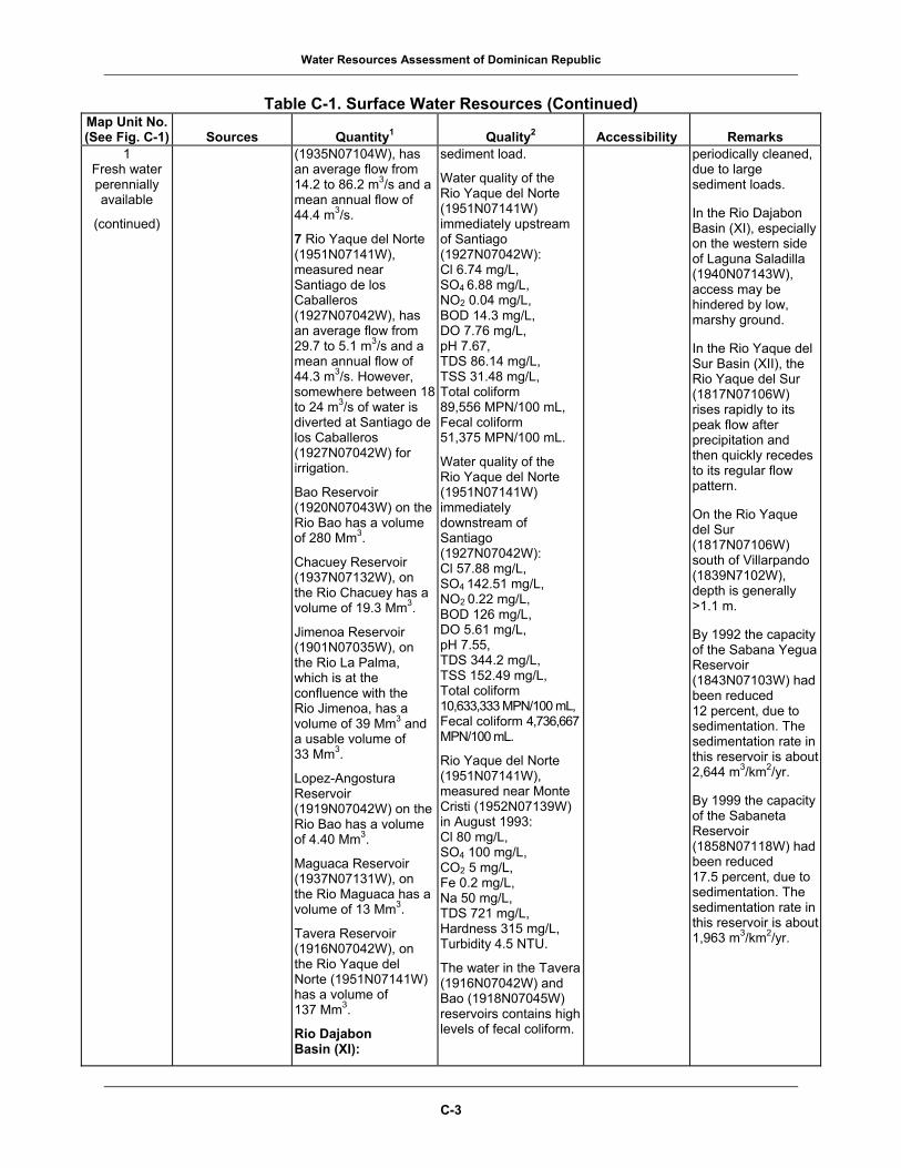
Water Resources Assessment of Dominican Republic
Table C-1. Surface Water Resources (Continued)
Map Unit No. 1
2
(See Fig. C-1) Sources Quantity Quality Accessibility Remarks 1
Fresh water perennially available
(continued)
(1935N07104W), has an average flow from 14.2 to 86.2 m3/s and a mean annual flow of 44.4 m3/s.
7 Rio Yaque del Norte (1951N07141W), measured near Santiago de los Caballeros (1927N07042W), has an average flow from 29.7 to 5.1 m3/s and a mean annual flow of 44.3 m3/s. However, somewhere between 18 to 24 m3/s of water is diverted at Santiago de los Caballeros (1927N07042W) for irrigation.
Bao Reservoir (1920N07043W) on the Rio Bao has a volume of 280 Mm3.
Chacuey Reservoir (1937N07132W), on the Rio Chacuey has a volume of 19.3 Mm3.
Jimenoa Reservoir (1901N07035W), on the Rio La Palma, which is at the confluence with the Rio Jimenoa, has a volume of 39 Mm3 and a usable volume of 33 Mm3.
Lopez-Angostura Reservoir (1919N07042W) on the Rio Bao has a volume of 4.40 Mm3.
Maguaca Reservoir (1937N07131W), on the Rio Maguaca has a volume of 13 Mm3.
Tavera Reservoir (1916N07042W), on the Rio Yaque del Norte (1951N07141W) has a volume of 137 Mm3.
Rio Dajabon Basin (XI):
sediment load.
Water quality of the Rio Yaque del Norte (1951N07141W) immediately upstream of Santiago (1927N07042W): Cl 6.74 mg/L, SO4 6.88 mg/L, NO2 0.04 mg/L, BOD 14.3 mg/L, DO 7.76 mg/L, pH 7.67, TDS 86.14 mg/L, TSS 31.48 mg/L, Total coliform 89,556 MPN/100 mL, Fecal coliform 51,375 MPN/100 mL.
Water quality of the Rio Yaque del Norte (1951N07141W) immediately downstream of Santiago (1927N07042W): Cl 57.88 mg/L, SO4 142.51 mg/L, NO2 0.22 mg/L, BOD 126 mg/L, DO 5.61 mg/L, pH 7.55, TDS 344.2 mg/L, TSS 152.49 mg/L, Total coliform 10,633,333 MPN/100 mL,Fecal coliform 4,736,667 MPN/100 mL.
Rio Yaque del Norte (1951N07141W), measured near Monte Cristi (1952N07139W) in August 1993: Cl 80 mg/L, SO4 100 mg/L, CO2 5 mg/L, Fe 0.2 mg/L, Na 50 mg/L, TDS 721 mg/L, Hardness 315 mg/L, Turbidity 4.5 NTU.
The water in the Tavera (1916N07042W) and Bao (1918N07045W) reservoirs contains high levels of fecal coliform.
periodically cleaned, due to large sediment loads.
In the Rio Dajabon Basin (XI), especially on the western side of Laguna Saladilla (1940N07143W), access may be hindered by low, marshy ground.
In the Rio Yaque del Sur Basin (XII), the Rio Yaque del Sur (1817N07106W) rises rapidly to its peak flow after precipitation and then quickly recedes to its regular flow pattern.
On the Rio Yaque del Sur (1817N07106W) south of Villarpando (1839N7102W), depth is generally >1.1 m.
By 1992 the capacity of the Sabana Yegua Reservoir (1843N07103W) had been reduced 12 percent, due to sedimentation. The sedimentation rate in this reservoir is about 2,644 m3/km2/yr.
By 1999 the capacity of the Sabaneta Reservoir (1858N07118W) had been reduced 17.5 percent, due to sedimentation. The sedimentation rate in this reservoir is about 1,963 m3/km2/yr.
C-3

Water Resources Assessment of Dominican Republic
Table C-1. Surface Water Resources (Continued)
Map Unit No. 1
2
(See Fig. C-1) Sources Quantity Quality Accessibility Remarks 1
Fresh water perennially available
(continued)
The area and the volume of Laguna Saladilla (1940N07143W) are unknown. However, it is estimated that 88 Mm3 of water annually can be safely extracted for irrigation.
Rio Yaque del Sur Basin (XII):
8 Rio Yaque del Sur (1817N07106W), measured near El Puente (1841N07104W) from 1976 to 1984, had a mean annual flow of 18.12 m3/s. The minimum recorded flow was 1.2 m3/s in June 1984, and the maximum recorded flow was 119 m3/s in September 1979.
9 Rio Yaque del Sur (1817N07106W), measured near Villarpando (1839N07102W), has a mean annual flow of 52 m3/s.
The Sabana Yegua Reservoir (1843N07103W) on the Rio Yaque del Sur has a volume of 422 Mm3.
The Sabaneta Reservoir (1858N07118W) on the Rio San Juan has a volume of 63 Mm3.
Rio Dajabon Basin (XI):
The Laguna Saladilla (1940N07143W) has an approximate TDS of 374 mg/L and has about 1,300 to 1,700 coliform bacteria per liter.
Rio Yaque del Sur Basin (XII):
The Rio Yaque del Sur (1817N07106W) has a high level of TSS.
2 Fresh water perennially available
Major perennial streams throughout the country.
Azua, Bani, and San Cristobal Basin (II):
Rio Haina (1825N07001W),
and
Rio Nizao (1814N07011W).
Small to moderate quantities of water are available year-round. Large quantities are occasionally available after large storm events, such as hurricanes or tropical storms. Moderate quantities are available during the high flow period, which generally occurs April through October.
Surface water is generally fresh, moderately hard to hard, highly turbid, and heavily contaminated with human and animal wastes. Biological contamination is most severe around and downstream of populated places.
Azua, Bani, and San Cristobal Basin (II):
Topography, transportation network, and vegetation may limit access and development of water points.
In the San Pedro de Macoris de and La Romana Basin (IV), access to the Rio Chavon (1824N06853W)
Larger streams in the Azua, Bani, and San Cristobal Basin (II) usually have streambanks between 9.2 and 15.4 m high near the mouths of rivers.
In the San Pedro de Macoris de and La Romana Basin (IV), the Rio Macoris (1826N06919W) is navigable for several
C-4

Water Resources Assessment of Dominican Republic
Table C-1. Surface Water Resources (Continued)
Map Unit No. 1
2
(See Fig. C-1) Sources Quantity Quality Accessibility Remarks 2
Fresh water perennially available
(continued)
Rio Ozama Basin (III):
Rio Isabela (1831N06954W),
and
Rio Yabacao (1834N06947W).
San Pedro de Macoris de and La Romana Basin (IV):
Rio Chavon (1824N06853W),
Rio Macoris (1826N06919W),
and
Rio Soco (1827N06912W).
Costa Norte Basin (VIII):
Rio Bajabonico (1953N07105W),
Rio Boba (1928N06952W),
Rio Nagua (1922N06950W),
and
Rio Yasica (1942N07022W).
Rio Yuna Basin (IX):
Rio Camu (1909N07006W),
and
Rio Jima (1910N07023W).
Rio Yaque del Norte Basin (X):
Rio Bao (1920N07043W),
Rio Mao (1935N07103W),
Selected stream gaging stations and average flows are listed below.
Azua, Bani, and San Cristobal Basin (II):
10 Rio Haina (1825N07001W), measured near El Caobal (1835N07010W), has an average flow from 4 to 18.5 m3/s and a mean annual flow of 9.6 m3/s.
11 Rio Nizao, measured near Higuana (1822N07016W), has an average flow from 9.6 to 22 m3/s and a mean annual flow of 15.8 m3/s.
Rio Ozama Basin (III):
The total average discharge from the streams in this basin is 50 m3/s.
San Pedro de Macoris de and La Romana Basin (IV):
Rio Chavon (1824N06853W) has an average flow from 3 to 15.1 m3/s and a mean annual flow of 7.9 m3/s.
Rio Macoris (1826N06919W) has an average flow from 3.8 to 23 m3/s and a mean annual flow of 14.7 m3/s.
Rio Soco (1827N06912W) has an average flow from 5 to 21 m3/s and a mean annual flow of 12.7 m3/s.
Rio Yuna Basin (IX):
12 Rio Camu (1909N07006W), measured near Concepcion de La
Streams in this basin have high levels of TSS.
Rio Ozama Basin (III):
Rio Isabela (1831N06954W), measuring location unknown, averaged from January to June 2001: Cl 26.5 mg/L, SO4 7 mg/L, Na 24.8 mg/L, pH 7.1,TDS 223 mg/L, Turbidity 9.9 NTU, Hardness 151 mg/L, Total coliform (range) <300 to 1,100,000 MPN/100 mL.
San Pedro de Macoris de and La Romana Basin (IV):
The rivers in this basin all have high levels of TSS.
Costa Norte Basin (VIII):
Streams in this basin have high TDS.
Rio Yuna Basin (IX):
The Rio Jima (1910N07023W) and Rio Camu (1909N07006W) have high levels of TSS.
Rio Yaque del Norte Basin (X):
The Rio Amina (1933N07101W) and the Rio Mao have high levels of TSS.
Rio Guayubin (1940N07124W), measured in May 1997: Cl 8 mg/L, SO4 8 mg/L,Na 3 mg/L, Fe 2 mg/L,CO2 9 mg/L, TDS 355 mg/L, Hardness 102 mg/L, Turbidity 70 NTU, Total Coliform 93,000 MPN/100 mL, Fecal Coliform 15,000 MPN/100 mL.
is difficult due to high, steep escarpments.
Other rivers in this basin may be steeply incised in their lower reaches.
In the Costa Norte Basin (VIII), the Rio Nagua (1922N06950W) flows through a mangrove swamp. It may briefly disappear in its lower course through the swamp.
kilometers, and is used to transport sugar.
The Rio Yabacao (1834N06947W) is the largest tributary to the Rio Ozama (1828N06953W).
In the San Pedro de Macoris de and La Romana Basin (IV), the Rio Macoris (1826N06919W) is generally deeper than 1.1 m.
In the Costa Norte Basin (VIII), the Rio Bajabonico (1953N07105W) and the Rio Yasica (1942N07022W) have high banks in their upper reaches. The Rio Bajabonico (1953N07105W) is only deeper than 1.1 m near its mouth.
The lower 16.2 to 32.4 km of the Rio Yasica (1942N07022W) is deeper than 1.1 m.
In the Rio Dajabon Basin (XI), the Rio Dajabon (1942N07145W) disappears in its lower course into a swamp. Access in this area is difficult due to low, marshy ground.
In the Rio Yaque del Sur Basin (XII), the Rio Yaque del Sur (1817N07106W), Rio del Medio (1843N07102W), Rio Mijo (1843N06953W), and Rio San Juan (1840N07104W) rise rapidly to peak flows after precipitation and then quickly
C-5

Water Resources Assessment of Dominican Republic
Table C-1. Surface Water Resources (Continued)
Map Unit No. 1
2
(See Fig. C-1) Sources Quantity Quality Accessibility Remarks 2
Fresh water perennially available
(continued)
Rio Amina (1933N07101W),
Rio Guayubin (1940N07124W),
and
Rio Jimenoa (1909N07039W).
Rio Dajabon Basin (XI):
Rio Dajabon (1942N07145W).
Rio Yaque del Sur Basin (XII):
Rio del Medio (1843N07102W),
Rio Mijo (1844N07108W),
Rio San Juan (1840N07104W),
and
Rio Yaque del Sur (1817N07106W).
Rio Artibonito Basin (XIV):
Rio Artibonito (1915N07247W).
Vega (1913N07031W), has an average flow from 5.2 to 23.3 m3/s and a mean annual flow of 11.7 m3/s. Rio Jima (1910N07023W) has an average flow from 4.1 to 15 m3/s and a mean annual flow of 8.8 m3/s.
Rio Yaque del Norte Basin (X):
13 Rio Guayubin (1940N07124W), measured near La Antonia (1938N07124W), has an average flow from 3.1 to 11.5 m3/s and a mean annual flow of 7.6 m3/s.
14 Rio Amina (1933N07101W), measured near Potrero (1928N07056W), has an average flow from 3.2 to 10.3 m3/s and a mean annual flow of 6.6 m3/s.
15 Rio Bao (1845N06948W), measured near Bao (1918N07048W), has an average flow from 7.4 to 22.2 m3/s and a mean annual flow of 10.6 m3/s.
16 Rio Jimenoa (1909N07039W), measured near Hato Viejo (1908N07037W), has an average flow from 5.4 to 8.4 m3/s and a mean annual flowof 6.9 m3/s.
Rio Mao (gaging station location unknown) has an average flow from 8.2 to 33.3 m3/s and a mean annual flow of 16.9 m3/s.
Rio Dajabon Basin (XI):
Rio Dajabon (1942N07145W) has an average flow from 6 to
Rio Yaque del Sur Basin (XII):
Rivers in this basin have high levels of TSS.
Rio San Juan (1840N07104W) measured below Sabaneta Reservoir (1858N07118W) in June 2000: pH 7.3, TDS 304 mg/L, PO4 0.2 mg/L, NO3 9.2 mg/L, Total Coliform 360 MPN/100 mL, Fecal coliform 360 MPN/100 mL.
Rio San Juan (1840N07104W) measured at the San Juan Bridge (1849N07114W) in June 2000: pH 7.9, TDS 267 mg/L, PO4 0.4 mg/L, NO3 10.6 mg/L, Total coliform >110,000 MPN/100 mL,Fecal coliform >110,000 MPN/100 mL.
Rio San Juan (1840N07104W) measured at the Rosario Bridge (1845N07112W) in June 2000: pH 8, TDS 449 mg/L, PO4 0.7 mg/L, NO3 10.6 mg/L, Total coliform 9,300 MPN/100 mL, Fecal coliform 9,300 MPN/100 mL.
Rio Artibonito Basin (XIV):
The Rio Artibonito (1915N07247W) has a high level of TSS.
recede to regular flow patterns.
In the Rio Artibonito Basin (XIV), the Rio Artibonito (1856N07153W) is very swift.
C-6

Water Resources Assessment of Dominican Republic
Table C-1. Surface Water Resources (Continued)
Map Unit No. 1
2
(See Fig. C-1) Sources Quantity Quality Accessibility Remarks 2
Fresh water perennially available
(continued)
19 m3/s and a mean annual flow of 11.8 m3/s.
Rio Yaque del Sur Basin (XII):
17 Rio del Medio (1843N07102W), measured near Boca de los Rios (1845N07102W), has an average flow from 3.3 to 13.3 m3/s and a mean annual flow of 7.2 m3/s.
18 Rio San Juan (1840N07104W), measured near Guazumal (1856N07116W), has an average flow from 4 to 20.1 m3/s and a mean annual flow of 10.2 m3/s.
19 Rio Yaque del Sur (1817N07106W), measured near Boca de los Rios (1845N07102W), has an average flow from 4.6 to 16 m3/s and a mean annual flow of 9 m3/s.
Rio Mijo (gaging station location unknown) has an average flow from 2.4 to 9.6 m3/s and a mean annual flow of 5.5 m3/s.
Rio Artibonito Basin (XIV):
20 Rio Artibonito (1915N07247W), measured near Pedro Santana (1906N07142W) from 1976 to 1984, has a mean annual flow of 18.83 m3/s. The minimum-recorded flow was 2.60 m3/s in March 1983, and the maximum recorded flow was 54.5 m3/s in October 1978.
C-7

Water Resources Assessment of Dominican Republic
Table C-1. Surface Water Resources (Continued)
Map Unit No. 1
2
(See Fig. C-1) Sources Quantity Quality Accessibility Remarks 3
Fresh water perennially available
Major perennial streams throughout the country.
Sierra Baoruco Basin (I):
Rio Nizaito (1800N07110W),
and
Rio Pedernales (1802N07144W).
Azua, Bani, and San Cristobal Basin (II):
Rio Ocoa (1816N07035W),
and
Rio Nigua (1822N07003W).
Rio Ozama Basin (III):
Arroyo Comate(1843N06937W), Rio Boya (1845N06948W),
and
Rio Mijo (1843N06953W).
San Pedro de Macoris and la Romana Basin (IV):
Rio Cumayasa (1823N06905W),
and
Rio Dulce (1825N06857W).
Higuey Basin (V):
Rio Yuma (1823N06836W).
Rio Yaque del Norte Basin (X):
Rio Maguaca (1942N07131W).
Rio Dajabon Basin (XI):
Rio Chacuey (1941N07139W).
Very small to small quantities of water are available year-round. Small quantities are available during the high flow period, which generally occurs in May. An exception to this is in the Cordillera Septentrional (1935N07045W), where the high flow period generally occurs between November and January. Large quantities are occasionally available after large storm events, such as hurricanes or tropical storms.
Selected stream gaging stations and average flows are listed below.
Sierra Baoruco Basin (I):
21 Rio Nizaito (1800N07110W), measured near Villa Nizao (1801N07111W) from 1976 to 1984, has a mean annual flow of 3.79 m3/s. The minimum recorded flow was 0.49 m3/s in May 1981, and the maximum recorded flow was 9.30 m3/s in June 1981. Rio Pedernales (1802N07144W) has an average flow from 0.5 to 1.1 m3/s and a mean annual flow of 0.9 m3/s.
Azua, Bani, and San Cristobal Basin (II):
22 Rio Nigua (1822N07003W), measured near San Cristobal (1825N07006W), has a mean annual flow of 2.7 m3/s. The average flow during March, the lowest flow period, is 0.6 m3/s.
23 Rio Ocoa (1816N07035W),
Surface water is generally fresh, moderately hard to hard, highly turbid, and heavily contaminated with human and animal wastes. Biological contamination is most severe around and downstream of populated places.
Azua, Bani, and San Cristobal Basin (II):
Streams in this basin have high levels of TSS.
Rio Ozama Basin (III):
Arroyo Comate (1843N06937W), measuring location unknown in November 1996: pH 7.6, Cl 9 mg/L, SO4 4 mg/L,CO2 6 mg/L, TDS 198 mg/L, Hardness 183 mg/L, Turbidity 2.1 NTU, Total coliform 2,300 MPN/100 mL.
Rio Boya (1845N06948W), measuring location unknown, averaged between 1995 and 1997: Cl 8.8 mg/L, SO4 5 mg/L, Na 7.6 mg/L, CO2 9.2 mg/L, pH 7.6, TDS 206.6 mg/L, Hardness 161.8 mg/L, Turbidity 3.2 NTU, Total coliform (range) >360 to 15,000 MPN /100 mL,Fecal coliform (range) 300 to 2,300 MPN/100 mL.
Rio Mijo measuring location unknown, averaged in 1997: Cl 8.3 mg/L, SO4 6.7 mg/L, Na 11.3 mg/L, Fe 0.3 mg/L, CO2 5 mg/L, pH 7.4, TDS 103 mg/L, Hardness 50.3 mg/L, Turbidity 20.6 NTU, Total coliform
Topography, transportation network, and vegetation may limit access and development of water points.
Streams in the Sierra Baoruco Basin (I) and in the Rio Yaque del Sur Basin (XII) are swift and in their youthful stages.
Larger streams in the Azua, Bani, and San Cristobal Basin (II) usually have streambanks between 9.2 and 15.4 m high near the mouths of rivers.
C-8

Water Resources Assessment of Dominican Republic
Table C-1. Surface Water Resources (Continued)
Map Unit No. 1
2
(See Fig. C-1) Sources Quantity Quality Accessibility Remarks 3
Fresh water perennially available
(continued)
Rio Yaque del Sur Basin (XII):
Rio Las Cuevas (1843N07102W).
Lago Enriquillo Basin (XIII):
Rio Las Damas (1823N07132W),
and
Rio Manguito (1827N07130W).
Rio Artibonito Basin (XIV):
Rio Macasia (1856N07152W).
measured near Mendez (1829N07029W), has an average flow from 1 to 3 m3/s and a mean annual flow of 1.9 m3/s. Parts of this river may go dry during extremely dry periods.
A spring, La Toma, location unknown, supplies an average flow of 0.6 m3/s to the Nigua River.
San Pedro de Macoris and La Romana Basin (IV):
Rio Cumayasa (1823N06905) has average flow from 0.09 to 5.1 m3/s and a mean annual flow of 3.2 m3/s.
Rio Dulce (1825N06857W) has an average flow from 0.5 to 3.3 m3/s and a mean annual flow of 1.6 m3/s.
Higuey Basin (V):
Rio Yuma (1912N06937W) has an average flow from 0.5 to 2.1 m3/s and a mean annual flow of 1.1 m3/s.
Rio Yaque del Sur Basin (XII):
Rio las Cuevas (gaging station location unknown) has an average flow from 1.5 to 8.4 m3/s and a mean annual flow of 4.5 m3/s.
Lago Enriquillo Basin (XIII):
Rio Las Damas (1823N07132W) has a flow of <1 m3/s.
Rio Manguito (1827N07130W) has a flow of <1 m3/s.
Rio Artibonito Basin (XIV):
1,700 MPN/100 mL, Fecal coliform 340 MPN/100 mL.
San Pedro de Macoris de and La Romana Basin (IV):
The rivers in this basin have high levels of TSS.
Higuey Basin (V):
The Rio Yuma (1912N06937W) carries a large sediment load.
Rio Yaque del Sur Basin (XII):
The Rio las Cuevas (1843N07102W) carries a high level of TSS.
Lago Enriquillo Basin (XIII):
Rio Las Damas (1823N07132W), measured near Duverge (1822N07131W) in June 2001: Cl 6 mg/L, SO4 2 mg/L,F 0.2 mg/L, CO2 8 mg/L, pH 7.6, TDS 175 mg/L, Turbidity 0.58 NTU, Hardness 162 mg/L, Total coliform 93 MPN/100 mL, Fecal coliform 23 MPN/100 mL.
Rio Manguito, measuring location unknown, in July 2001:Cl 15 mg/L, SO4 5 mg/L, F 0.3 mg/L, CO2 3 mg/L, pH 8.1, TDS 210 mg/L, Turbidity 2.4 NTU, Hardness 175 mg/L, Total coliform 23,000 MPN/100 mL, Fecal coliform 2,300 MPN/100 mL.
Rio Artibonito Basin (XIV):
Rio Macasia (1856N07152W),
C-9

Water Resources Assessment of Dominican Republic
Table C-1. Surface Water Resources (Continued)
Map Unit No. 1
2
(See Fig. C-1) Sources Quantity Quality Accessibility Remarks 3
Fresh water perennially available
(continued)
Rio Macasia (1856N07152W) has an average flow from 1 to 7 m3/s and a mean annual flow of 3.3 m3/s.
measured near Las Matas de Farfan (1852N07131W) in July 2001: Cl 14 mg/L, SO4 5 mg/L, Fe 0.1 mg/L, F 0.5 mg/L, CO2 7, pH 7.7, TDS 233 mg/L, Turbidity 14.8 NTU, Hardness 208 mg/L, Total coliform 23,000 MPN/100 mL, Fecal coliform 4,300 MPN/100 mL.
4 Fresh water seasonally available
Major intermittent streams throughout the country.
Meager to moderate quantities are available during the high flow period, which generally occurs from April to October. An exception to this is in the Cordillera Septentrional (1935N07045W), where the high flow period generally occurs between November and January. These streams may go dry during the low flow period which occurs from November to March.
Surface water is generally fresh, moderately hard to hard, highly turbid, and heavily contaminated with human and animal wastes. Biological contamination is most severe around and downstream of populated places.
Topography, transportation network, and vegetation may limit access and development of water points.
5 Fresh water
scarce or lacking
Fresh water that is quickly absorbed or channeled into the subsurface limestone aquifer.
Sources are in areas of the following locations:
Sierra Baoruco Basin (I);
Rio Ozama Basin (III);
Higuey Basin (V);
Miches and Sabana de la Mar Basin (VI);
Rio Yuna Basin (IX).
Meager to very small quantities of fresh water are available from streams immediately following heavy precipitation, usually from April to October. However, there is generally little to no surface drainage. These areas are underlain by karstic limestone. Any rain that falls may temporarily flow on the surface, but is quickly channeled into the subsurface through gullies, sinkholes, and caves.
Water in these areas is generally fresh, but very hard.
The rugged nature of the cockpit country, transportation network, and vegetation may limit access and development of water points.
6 Fresh water
scarce or lacking
Brackish to saline streams, lakes, mangrove swamps, and marshes.
Meager to enormous quantities of brackish to saline water may be available in streams due to saltwater
Water in these areas is generally brackish to saline. However, fresh water may exist in these areas during high
Topography, transportation network, and vegetation may limit access and
In the Rio Yaque del Sur Basin (XII), the Rio Yaque del Sur (1817N07106W) rises rapidly to its
C-10

Water Resources Assessment of Dominican Republic
Table C-1. Surface Water Resources (Continued)
Map Unit No. 1
2
(See Fig. C-1) Sources Quantity Quality Accessibility Remarks 6
Fresh water scarce or lacking
(continued)
Mangrove swamps and marshes are scattered along the entire coast.
Sierra Baoruco Basin (I):
Laguna Oviedo (1745N07122W).
Rio Ozama Basin (II):
The lower reaches of the Rio Ozama (1828N06910W).
San Pedro de Macoris and La Romana Basin (IV):
The lower reaches of the Rio Macoris (1826N06919W),
Rio Soco (1827N06912W),
and
Rio Cumayasa (1823N06905W).
Higuey Basin (V):
Laguna de Bavaro (1839N06823W).
Miches and Sabana de la Mar Basin (VI):
Laguna Redonda (1901N06857W).
Costa Norte Basin (VIII):
Numerous mangrove swamps and marshes along the coast.
Rio Yaque del Norte Basin (X):
The lower reaches of the Rio Yaque del Norte (1951N07141W).
Rio Yaque del Sur Basin (XII):
The lower reaches of the Rio Yaque
intrusion. Very large to enormous quantities of brackish to saline water are available year-round from lakes and ponds.
Lago Enriquillo Basin (XIII):
Lago Enriquillo (1831N07140W) has a maximum depth of 2 m and a surface area of 265 km2.
flow, which generally occurs from April to October. An exception to this is in the Cordillera Septentrional (1935N07045W) where the high flow period generally occurs between November and January.
Miches and Sabana de la Mar Basin (VI):
Laguna Redonda (1901N06857W) is brackish.
Lago Enriquillo Basin (XIII):
Lago Enriquillo (1831N07140W), TDS 43,000 mg/L.
development of water points.
peak flow after precipitation and then quickly recedes to its regular flow patterns.
C-11

Water Resources Assessment of Dominican Republic
Table C-1. Surface Water Resources (Continued)
Map Unit No. 1
2
(See Fig. C-1) Sources Quantity Quality Accessibility Remarks 6
Fresh water scarce or lacking
(continued)
del Sur (1817N07106W).
Lago Enriquillo Basin (XIII):
Lago Enriquillo (1831N07140W).
1Quantitative Terms: Enormous = >5,000 m3/s (176,550 ft3/s) Very large = >500 to 5,000 m3/s (17,655 to
176,550 ft3/s) Large = >100 to 500 m3/s (3,530 to 17,655 ft3/s) Moderate = >10 to 100 m3/s (350 to
3,530 ft3/s) Small = >1 to 10 m3/s (35 to 350 ft3/s) Very small = >0.1 to 1 m3/s (3.5 to 35 ft3/s) Meager = >0.01 to 0.1 m3/s (0.35 to
3.5 ft3/s) Unsuitable = <0.01 m3/s (0.35 ft3/s)
2Qualitative Terms: Fresh water = maximum TDS <1,000 mg/L;
maximum chlorides <600 mg/L; and maximum sulfates <300 mg/L
Brackish water = maximum TDS >1,000 mg/L but <15,000 mg/L Saline water = TDS >15,000 mg/L Hardness Terms: Soft = 0 to 60 mg/L CaCO3 Moderately hard = 61 to 120 mg/L CaCO3 Hard = 121 to 180 mg/L CaCO3 Very hard = >180 mg/L CaCO3
U.S. Surface Water Criteria: The Safe Drinking Water Act states that the number of coliforms must be less than 1 per 100 milliliters for water to be considered potable.
3Geographic coordinates list latitude first for the Northern (N) or Southern (S) Hemisphere and longitude second for the Eastern (E) or Western (W) Hemisphere. For example:
Aguacate Reservoir......(1829N07018W)
Geographic coordinates for the Aguacate Reservoir that are given as 1829N07018W equal 18º29’ N, 70º18’ W and can be written as a latitude of 18 degrees and 29 minutes north and a longitude of 70 degrees and 18 minutes west. Coordinates are approximate. Geographic coordinates are sufficiently accurate for locating features on the country-scale map. Geographic coordinates for rivers are generally at the river mouth.
Note: As = arsenic BOD = biological oxygen
demand CaCO3 = calcium carbonate Cd = cadmium CO2 = carbon dioxide DO = dissolved oxygen F = fluoride Fe = iron gal/min = gallons per minute
Hg = mercury km2 = square kilometers L/min = liters per minute m3/s = cubic meters per second m/s = meters per second mg/L = milligrams per liter mL = milliliters Mm3 = million cubic meters MPN = most probable number Na = sodium
NO3 = nitrate NTU = nephelometric turbidity
units pH = potential of hydrogen PO4 = phosphate Pb = lead SO4 = sulfate TDS = total dissolved solids TSS = total suspended solids yr = year
Conversion Chart: To Convert Multiply by To Obtain cubic meters per second 15,800 gallons per minute cubic meters per second 60,000 liter per minute cubic meters per second 35.31 cubic feet per second
C-12

Water Resources Assessment of Dominican Republic
Table C-2. Ground Water Resources
Map Unit No. (See Fig. C-2)
Aquifer Characteristics Quantity1
Quality2 Aspects of Ground Water Development Remarks
1 Fresh water
generally plentiful
Quaternary to Recent age alluvial aquifers are composed primarily of sand and gravel interbedded with clay. Maximum observable thickness is 200 m.
These aquifers are located in the following areas:
Provincia de Azua (1835N07040W) in the Azua Plain (1830N07045W),3
Provincia de Barahona (1810N07115W),
Provincia de Dajabon (1930N07135W),
Provincia de Duarte (1915N07005W),
Provincia de Independencia (1815N07130W),
Provincia de la Romana (1830N06858W),
Provincia de la Vega (1907N07037W),
Provincia Maria Trinidad Sanchez (1930N07000W),
Provincia de Monsenor Nouel (1855N07025W),
Provincia de Monte Cristi (1940N07125W),
Provincia de Monte Plata (1850N06950W),
Provincia de Pedernales (1804N07129W),
Provincia de
Small to large quantities of ground water are available from alluvial aquifers. Large quantities of ground water are available as percentage of clay content in the aquifer decreases.
Provincia de Azua (1835N07040W): Yields from 84 drilled wells range from 1.4 to 28 L/s with an average yield of 14 L/s. Most of the ground water extracted is used for irrigation.
Aquifer test parameters from several wells recorded in 1966 in the Azua Plain (1830N07045W) area showed transmissivity ranged from 2,300 to 15,000 m2/d.
Provincia de la Vega (1907N07037W): Yields from 15 drilled wells range from 14 to 28 L/s with an average well yield of 21 L/s.
Provincia de Puerto Plata (1945N07045W): Yields from each of the 11 drilled wells are just under 1.4 L/s.
Provincia de San Cristobal (1833N07012W): Before 1990, 80 boreholes drilled in the Rio Nigua (1922N06950W) area showed the saturated zone of the alluvial aquifer is at least 16 m
Ground water is generally fresh. Cl concentrations generally range from 10 to 100 mg/L. TDS are 100 to 600 mg/L. Ground water is soft to moderately hard.
Near coastlines where seawater intrusion is likely, ground water may be nonpotable unless treated.
Within or near urban areas, shallow ground water, especially in coastal areas, is contaminated with biological and/or chemical wastes from the problem of uncollected garbage.
Within close proximity to farm fields, fertilizers diminish the potability of shallow ground water with nitrogen and other chemicals.
1 A spring near El Rosario (1845N07112W) had the following water quality parameters recorded in 1966: TDS 511 mg/L, Ca 172 mg/L, Mg 64 mg/L, Cl 64 mg/L.
2 One well in Las Yayas (1915N07029W) had the following water quality results from ground water sampled on 21 June 2001: pH 7.2, SO4 34 mg/L, Cl 50 mg/L.
3 Near Los Jovillos
Depth to aquifer generally ranges from 5 to 50 m, but can be locally up to 200 m.
Care should be taken to avoid excessive pumping along coastal areas where saline water underlies fresh water zones. In these coastal areas, reverse osmosis purification units may be needed to treat nonpotable saline water.
From 1966 to 1972, measurements in the alluvium within the Provincia de Azua indicate a 2.9 m decrease in the water table.
The alluvium within the Provincia de la Romana has experienced an annual decrease of 0.3 m in the water table.
Provincia de San Cristobal (1833N07012W): Within the Arroyo Nigua (1822N07030W) basin, all wells sited for long-term pumping must be situated at least 3,030 m upstream from the mouth of the river.
Access is easy on unimproved or improved roads, but may be locally hindered in areas due to dense scrub forest or thorn brush.
Provincia de Azua (1835N07040W): Well depths of 285 drilled wells range from <25 m to >200 m with an average depth of 100 m.
Provincia de Dajabon (1930N07135):
Aquifers are recharged by rainfall and by percolation from rivers and canals.
Alluvial aquifers are suitable for municipal or irrigation wells.
C-13

Water Resources Assessment of Dominican Republic
Table C-2. Ground Water Resources, Continued
Map Unit No. Aquifer 1
2
Aspects of Ground (See Fig. C-2) Characteristics Quantity Quality Water Development Remarks
1 Fresh water
generally plentiful
(continued)
Peravia (1830N07027W),
Provincia de Puerto Plata (1945N07045W),
Provincia de San Cristobal (1833N07012W),
Provincia de San Juan (1850N07115W),
and
Provincia de Santiago (1925N07055W).
thick. Also, the aquifer test parameters in the alluvial aquifers, as observed in 1990, transmissivity ranges from 620 to 4,960 m2/d. Storage coefficient ranges from 0.0002 to 0.001.
Provincia de San Juan (1850N07115W): Yields from 77 wells range from 1.4 to 14 L/s with an average yield of 7 L/s.
Provincia de Santiago (1925N07055W): Yields from 169 wells range from 1.4 to 28 L/s with an average yield of 14 L/s.
(1846N06959W),the following ground water quality results were recorded from a well in 1966 with a water depth of 30 m below ground surface: TDS 382 mg/L, Ca 200 mg/L, Mg 56 mg/L, Cl 19 mg/L.
4 Near Los Negros (1913N07042W), the following ground water quality parameters were recorded from a well in 1966 with a water depth of 20 m below ground surface: TDS 566 mg/L, Ca 52 mg/L, Mg 216 mg/L, Cl 60 mg/L, Fe 0.4 mg/L.
Well depths of 40 drilled wells range from <25 m to 50 m with an average depth of 37 m.
Provincia de Independencia (1815N07130W): Well depths of 25 drilled wells range from 25 to 75 m with an average depth of 50 m.
Provincia de Monte Cristi (1940N07125W): Well depths of 55 drilled wells range from <25 to 75 m with an average depth of 50 m.
Provincia de Peravia (1830N07027W): Well depths of 88 drilled wells range from <25 to 100 m with an average depth of 70 m.
Provincia de Puerto Plata (1945N07045W): Well depths of 46 drilled wells range from <25 to 50 m with an average depth of 37 m.
Provincia de San Cristobal (1833N07012W): Well depths of 18 drilled wells range from 25 to 50 m with an average depth of 37 m.
2 Fresh water
generally plentiful
Tertiary to Quaternary age limestone that is fractured and/or faulted.
Major aquifers include the following rock units:
The Eocene to Oligocene age La Toca
Very small to very large quantities of ground water are available. Large quantities of fresh water are likely in limestone with a high density of fractures and/or solution cavities.
Provincia de Altagracia (1835N06838W):
Ground water is generally fresh, except near coastal areas where it is brackish to saline and is generally very hard with high pH.
Within or near urban areas, shallow ground water, especially in coastal areas, is
Depth to aquifer generally ranges from 5 to 25 m for low-lying areas and 100 to 200 m for mountainous areas. Most water is contained within solution cavities and fractures within the limestone.
Care should be taken to avoid excessive
Aquifers are recharged by rainfall and by percolation from rivers.
Most areas are suitable for hand pump wells. Well sites on large fractures or solution cavities may be suitable for tactical, high-
C-14
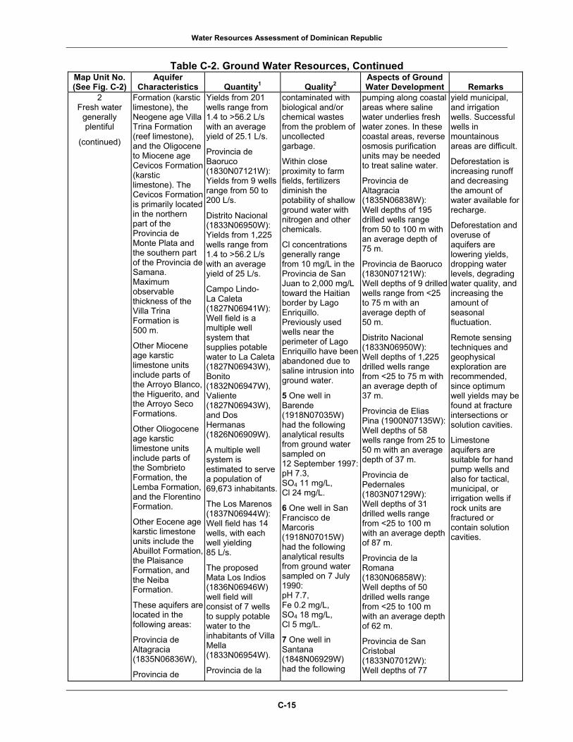
Water Resources Assessment of Dominican Republic
Table C-2. Ground Water Resources, Continued
Map Unit No. Aquifer 1
2
Aspects of Ground (See Fig. C-2) Characteristics Quantity Quality Water Development Remarks
2 Fresh water
generally plentiful
(continued)
Formation (karstic limestone), the Neogene age Villa Trina Formation (reef limestone), and the Oligocene to Miocene age Cevicos Formation (karstic limestone). The Cevicos Formation is primarily located in the northern part of the Provincia de Monte Plata and the southern part of the Provincia de Samana. Maximum observable thickness of the Villa Trina Formation is 500 m.
Other Miocene age karstic limestone units include parts of the Arroyo Blanco, the Higuerito, and the Arroyo Seco Formations.
Other Oliogocene age karstic limestone units include parts of the Sombrieto Formation, the Lemba Formation, and the Florentino Formation.
Other Eocene age karstic limestone units include the Abuillot Formation, the Plaisance Formation, and the Neiba Formation.
These aquifers are located in the following areas:
Provincia de Altagracia (1835N06836W),
Provincia de
Yields from 201 wells range from 1.4 to >56.2 L/s with an average yield of 25.1 L/s.
Provincia de Baoruco (1830N07121W): Yields from 9 wells range from 50 to 200 L/s.
Distrito Nacional (1833N06950W): Yields from 1,225 wells range from 1.4 to >56.2 L/s with an average yield of 25 L/s.
Campo Lindo- La Caleta (1827N06941W): Well field is a multiple well system that supplies potable water to La Caleta (1827N06943W), Bonito (1832N06947W), Valiente (1827N06943W), and Dos Hermanas (1826N06909W).
A multiple well system is estimated to serve a population of 69,673 inhabitants.
The Los Marenos (1837N06944W): Well field has 14 wells, with each well yielding 85 L/s.
The proposed Mata Los Indios (1836N06946W) well field will consist of 7 wells to supply potable water to the inhabitants of Villa Mella (1833N06954W).
Provincia de la
contaminated with biological and/or chemical wastes from the problem of uncollected garbage.
Within close proximity to farm fields, fertilizers diminish the potability of shallow ground water with nitrogen and other chemicals.
Cl concentrations generally range from 10 mg/L in the Provincia de San Juan to 2,000 mg/L toward the Haitian border by Lago Enriquillo. Previously used wells near the perimeter of Lago Enriquillo have been abandoned due to saline intrusion into ground water.
5 One well in Barende (1918N07035W) had the following analytical results from ground water sampled on 12 September 1997:pH 7.3, SO4 11 mg/L, Cl 24 mg/L.
6 One well in San Francisco de Marcoris (1918N07015W) had the following analytical results from ground water sampled on 7 July 1990: pH 7.7, Fe 0.2 mg/L, SO4 18 mg/L, Cl 5 mg/L.
7 One well in Santana (1848N06929W) had the following
pumping along coastal areas where saline water underlies fresh water zones. In these coastal areas, reverse osmosis purification units may be needed to treat saline water.
Provincia de Altagracia (1835N06838W): Well depths of 195 drilled wells range from 50 to 100 m with an average depth of 75 m.
Provincia de Baoruco (1830N07121W): Well depths of 9 drilled wells range from <25 to 75 m with an average depth of 50 m.
Distrito Nacional (1833N06950W): Well depths of 1,225 drilled wells range from <25 to 75 m with an average depth of 37 m.
Provincia de Elias Pina (1900N07135W): Well depths of 58 wells range from 25 to 50 m with an average depth of 37 m.
Provincia de Pedernales (1803N07129W): Well depths of 31 drilled wells range from <25 to 100 m with an average depth of 87 m.
Provincia de la Romana (1830N06858W): Well depths of 50 drilled wells range from <25 to 100 m with an average depth of 62 m.
Provincia de San Cristobal (1833N07012W): Well depths of 77
yield municipal, and irrigation wells. Successful wells in mountainous areas are difficult.
Deforestation is increasing runoff and decreasing the amount of water available for recharge.
Deforestation and overuse of aquifers are lowering yields, dropping water levels, degrading water quality, and increasing the amount of seasonal fluctuation.
Remote sensing techniques and geophysical exploration are recommended, since optimum well yields may be found at fracture intersections or solution cavities.
Limestone aquifers are suitable for hand pump wells and also for tactical, municipal, or irrigation wells if rock units are fractured or contain solution cavities.
C-15

Water Resources Assessment of Dominican Republic
Table C-2. Ground Water Resources, Continued
Map Unit No. Aquifer 1
2
Aspects of Ground (See Fig. C-2) Characteristics Quantity Quality Water Development Remarks
2 Fresh water
generally plentiful
(continued)
Baoruco (1830N07121W),
Provincia de Barahona (1810N07115W),
Provincia Duarte (1915N07005W),
Provincia Espaillat (1930N07027W),
Provincia de Elias Pina (1900N07135W),
Provincia de Independencia (1815N07130W),
Provincia de la Romana (1830N06858W),
Provincia Maria Trinidad Sanchez (1930N07000W),
Provincia de Pedernales (1804N07130W),
Provincia de Puerto Plata (1945N07045W),
Provincia de Salcedo (1925N07020W),
Provincia de Samana (1915N06927W),
Provincia de San Cristobal (1833N07012W),
Provincia de San Juan (1850N07115W),
and
Provincia de San Pedro de Macoris (1830N06920W).
Romana (1830N06858W): Yields from each of 48 wells average 1.4 L/s.
Provincia de Monte Plata (1850N06950W): Yields from 44 wells average 1.4 L/s.
Provincia de San Juan (1850N07115W): Yields from 34 wells average 1.4 L/s.
Provincia de San Pedro de Macoris (1830N06920W): Proposed well field would capture ground water from the watersheds of the Rio Casui (1835N06923W) and Rio Brujuela (1830N06936W). Water would then be transported to supply potable water to 230,400 inhabitants on the east side of Santo Domingo.
water quality results from ground water sampled on 21 December 1997:pH 6.7, SO4 3 mg/L,Cl 18 mg/L.
8 One well in Villa Jaragua (1829N07130W) had the following water quality results from ground water sampled on 10 March 2001: pH 7.7, TDS 279 mg/L CaCO3 164 mg/L, SO4 10 mg/L, Cl 26 mg/L.
drilled wells range from <25 to 100 m with an average depth of 50 m.
Provincia de San Pedro de Marcoris (1830N06920W): Wells depths of 274 drilled wells range from <25 to 75 m with an average depth of 50 m.
3 Fresh water
locally plentiful
Primarily differentiated and undifferentiated Tertiary age sedimentary rocks with minor amounts of metamorphic
Very small to large quantities of ground water are available. Very large quantities may be available locally.
Ground water is generally fresh, but is locally very hard with high pH in limestone.
Within or near urban areas, shallow ground water,
Depth to water ranges from 5 to 25 m for low-lying areas and 100 to 200 m for mountainous areas.
Care should be taken to avoid excessive pumping along coastal
Aquifers are recharged by rainfall and by percolation from rivers and canals.
The low-lying areas are suitable for hand pump
C-16

Water Resources Assessment of Dominican Republic
Table C-2. Ground Water Resources, Continued
Map Unit No. Aquifer 1
2
Aspects of Ground (See Fig. C-2) Characteristics Quantity Quality Water Development Remarks
3 Fresh water
locally plentiful
(continued)
rocks. Differentiated rocks consist of conglomerate, limestone, sandstone, and schist with minor clay.
Major aquifers include parts of the following Miocene age rock units all consisting of conglomerate, sandstone, and schist: the Arroyo Blanco Formation, the Arroyo Seco Formation, and the Via Formation.
Other aquifers include the probable Oligocene age Luperon Formation (calcareous sandstone and limestone) and the probable Eocene age La Isla Formation (algal limestone).
The aquifers are located in the following areas:
Provincia de Azua (1835N07040W),
Provincia de Baoruco (1830N07121W),
Provincia de Elias Pina (1900N07135W),
Provincia de la Vega (1907N07037W),
Provincia de Monte Cristi (1940N0725W),
Provincia de Peravia (1830N07027W),
Provincia de Santiago (1925N07055W): La Joya (1923N07107W) well field has 16 wells, with each well yielding about 100 L/s.
especially in coastal areas, is contaminated with biological and/or chemical wastes from the problem of uncollected garbage. Cl concentrations are about 70 mg/L.
areas where saline water underlies fresh water zones. In these coastal areas, reverse osmosis purification units may be needed to treat nonpotable saline water.
Lack of adequate road network, steep slopes, and dense vegetation hinder accessibility in mountainous areas.
Provincia de Santiago Rodriquez (1925N07120W): Well depths of 34 drilled wells range from <25 to 200 m.
wells. Well sites on fractures or solution cavities may be suitable for tactical wells. Areas suitable for high-yield municipal and irrigation wells are encountered in conglomerate, sandstone, and limestone.
Remote sensing techniques and geophysical exploration are recommended for optimum well yields.
Deforestation is increasing runoff and decreasing the amount of water available for recharge.
Deforestation and overuse of aquifers are lowering yields, dropping water levels, degrading water quality, and increasing the amount of seasonal fluctuation.
C-17

Water Resources Assessment of Dominican Republic
Table C-2. Ground Water Resources, Continued
Map Unit No. Aquifer 1
2
Aspects of Ground (See Fig. C-2) Characteristics Quantity Quality Water Development Remarks
3 Fresh water
locally plentiful
(continued)
Provincia de Puerto Plata (1945N07045W),
Provincia de San Cristobal (1833N07012W),
Provincia de Santiago (1925N07055W),
and
Provincia de Santiago Rodriquez (1925N07120W).
4 Fresh water
scarce or lacking
Quaternary age lacustrine deposits consisting of clay with some sand and gravel. Unit frequently occurs close to the coastline in narrow banded deposits. Maximum thickness of the unit is 10 m.
These aquifers are located in the following areas:
Provincia de Baoruco (1830N07121W),
Distrito Nacional (1833N06950W),
Provincia de Duarte (1915N07005W),
Provincia Espaillat (1930N07027W),
Provincia de El Seibo (1848N06903W),
Provincia de Independencia (1815N07130W),
Provincia de la Altagracia (1835N06838W),
Provincia Maria Trinidad Sanchez (1930N07000W),
Provincia de
Very small to small quantities of ground water are available. Enormous quantities of water may be situated in sand and gravel lenses.
Distrito Nacional (1833N06950W): Guaricano (1833N06956W) well field has 6 wells that supply potable water to the town of Guaricano (1833N06956W). Each well has a yield of 19 to 28 L/s.
Provincia de San Cristobal (1940N07125W): Yields from 40 wells range from 1.4 to 4.21 L/s with an average yield of 2 L/s.
The proposed Los Alcarizos (1831N07001W): Well field will exploit ground water from the watershed of the Rio Haina (1825N07001W) to supply potable water to the inhabitants of Los
Ground water is generally fresh and soft in the inland areas and saline along coastal areas and east of Lago Enriquillo. The pH of the ground water in the inland areas is low.
Within or near urban areas, shallow ground water, especially in coastal areas, is contaminated with biological and/or chemical wastes from the problem of uncollected garbage.
9 One well in Fantino (1907N07018W) had the following water quality results from ground water sampled on 23 April 1996: pH 7.4, SO4 8 mg/L, Cl 3 mg/L.
10 One well in Los Indios de Cenovi (1916N07022W) had the following water quality results from ground water sampled on 7 March 1996: pH 7.4, SO4 20 mg/L,
Depth to water ranges from <1 to 10 m. Care should be taken to avoid excessive pumping along coastal areas where saline water underlies fresh water zones. In these coastal areas, reverse osmosis purification units may be needed to treat nonpotable saline water.
Provincia de San Cristobal (1833N07012W): Well depths of 41 drilled wells range from 25 to 75 m with an average depth of 50 m.
Aquifers are recharged by rainfall and by percolation from rivers.
Most areas are unsuitable for hand pump wells, except where pockets of sand and gravel are encountered. Pockets of sand and gravel can be found utilizing geophysical techniques.
Deforestation is increasing runoff and decreasing the amount of water available for recharge.
Deforestation and overuse of aquifers are lowering yields, dropping water levels, degrading water quality, and increasing the amount of seasonal fluctuation.
C-18

Water Resources Assessment of Dominican Republic
Table C-2. Ground Water Resources, Continued
Map Unit No. Aquifer 1
2
Aspects of Ground (See Fig. C-2) Characteristics Quantity Quality Water Development Remarks
4 Fresh water
scarce or lacking
(continued)
Monte Cristi (1940N07125W),
Provincia de Salcedo (1925N07020W),
and
Provincia de Samana (1915N06927W),
Provincia de San Cristobal (1833N07012W),
Provincia Sanchez Ramirez (1900M07010W),
Provincia de Santiago (1925N07055W).
Alcarizos (1831N07001W).
Cl 121 mg/L.
11 One well in Los Llanos (1836N06959W) had the following analytical results from ground water sampled on 29 September 2001: pH 7.6, CaCO3 174 mg/L, SO4 6.0 mg/L, Cl 29 mg/L.
12 One well in Pimentel (1911N07006W) had the following water quality results from ground water sampled on 22 July 2001: pH 7.6, CaCO3 141 mg/L, SO4 16 mg/L, Cl 10 mg/L, TDS 189 mg/L.
13 One well in Pueblo Viejo (1917N07032W) had the following water quality results from ground water sampled on 16 April 1998: pH 8.4, SO4 76 mg/L, Cl 46 mg/L.
5 Fresh water
scarce or lacking
Primarily faulted and/or fractured igneous and metamorphic rocks.
Major aquifers include the following Cretaceous age rock units:
The Rio San Juan Complex includes the Jagna Clara Melange (metamorphic breccia), Puerca Gorda Schist (foliated greenschist), Arroyo Sabana
Meager to very small quantities of ground water are available.
Provincia de El Seibo (1848N06903W): Yields from 83 wells range from 1.4 to 7.02 L/s with an average yield of 2 L/s.
Provincia de Santiago (1925N07055W): Yields from each of the 20 wells averaged 1.4 L/s.
Ground water is generally fresh and soft with low pH. Cl concentrations range from 15 to 50 mg/L.
14 One well in Cotui (1903N07009W) had the following analytical results from ground water sampled on 23 November 1995: pH 7.2, SO4 25 mg/L, Cl 10 mg/L.
15 One well in Santa Cruz de El Seibo (1846N06902W)
Depth to water varies from <50 to 200 m depending upon structural conditions in bedrock. Depth to water is probably <50 m where fractures are abundant. Beyond 50 m in depth, fractures generally disappear, but isolated pockets of water may exist in fault zones up to 200 m in depth.
Ground water exploration costs are probably very expensive and may not be economically feasible.
Aquifers are recharged by rainfall and by percolation from rivers.
Most areas are unsuitable for hand pump wells, except where fractures can be encountered during drilling.
Deforestation is increasing runoff and decreasing the amount of water available for recharge.
Deforestation and overuse of
C-19

Water Resources Assessment of Dominican Republic
Table C-2. Ground Water Resources, Continued
Map Unit No. Aquifer 1
2
Aspects of Ground (See Fig. C-2) Characteristics Quantity Quality Water Development Remarks
5 Fresh water
scarce or lacking
(continued)
Melange (metamorphic and altered volcanics), Hicotea Schist (fractured greenschist), Rio Boba Intrusive (gabbros and diorites), and Cuaba Amphibolites (gneiss).
The Duarte Complex includes a mix of metamorphic rocks to include greenstone, amphibolite, and metabasic rocks intruded by grantic plutons.
The Tireo Group includes a mix of tuff, metabasalt, and lava flows. Total thickness of the Tireo Group is >4,000 m.
The Maimon Formation includes metavolcanics (metabasalts and schists), Loma Caribe Peridotite (serpentinized peridotite).
Other major aquifers (Palocene to Eocene age) include: Imbert Formation (interbedded sandstone, conglomerate, and tuff); and the Gasper Hernandez Serpentinites (serpentinite).
Total thickness of the Imbert Formation is 200 m.
These aquifers are located in the
had the following analytical results from ground water sampled on 26 February 2001: pH 7.6, Fe 0.1 mg/L, CaCO3 109 mg/L, SO4 3.0 mg/L, Cl 7 mg/L.
Lack of adequate road network, steep slopes, and dense vegetation hinder accessibility in mountainous areas.
Hard rock drilling methods are recommended, such as air rotary or percussion drilling.
aquifers are lowering yields, dropping water levels, degrading water quality, and increasing the amount of seasonal fluctuation.
Remote sensing techniques and geophysical exploration are recommended, since optimum well yields are usually found at fault and/or fracture intersections.
C-20

Water Resources Assessment of Dominican Republic
Table C-2. Ground Water Resources, Continued
Map Unit No. Aquifer 1
2
Aspects of Ground (See Fig. C-2) Characteristics Quantity Quality Water Development Remarks
5 Fresh water
scarce or lacking
(continued)
following areas:
Provincia de Azua (1835N07040W),
Provincia de Barahona (1810N07115W),
Provincia de Dajabon (1930N07135W),
Provincia de Duarte (1915N07005W),
Provincia de El Seibo (1848N06903W),
Provincia de Espaillat (1930N07027W),
Provincia de Hato Mayor (1850N06920W),
Provincia de la Vega (1907N07037W),
Provincia de Monsenor Nouel (1855N07025W),
Provincia de Monte Plata, (1850N069450W),
Provincia de Peravia (1830N07027W),
Provincia de Puerto Plata (1945N07045W),
Provincia de Salcedo (1925N07020W),
Provincia de San Cristobal (1833N07012W),
Provincia de Sanchez Ramirez (1900N07010W),
and
Provincia de Santiago (1925N07055W).
C-21

Water Resources Assessment of Dominican Republic
Table C-2. Ground Water Resources, Continued
Map Unit No. Aquifer 1
2
Aspects of Ground (See Fig. C-2) Characteristics Quantity Quality Water Development Remarks
6 Fresh water
scarce or lacking
Generally Recent age marsh or swamp deposits consisting of clay.
In the eastern part of Provincia de Samana, Cretaceous age slightly metamorphosed granitic rocks are present.
Within the Provincia de San Juan, a probable Cretaceous age basalt breccia is present.
These aquifers are located in the following areas:
Provincia de Azua (1835N07040W),
Provincia de Baoruco (1830N07121W),
Provincia de Barahona (1810N07115W),
Provincia de Duarte (1915N07005W),
Provincia de Independencia (1815N07130W),
Provincia de Pedernales (1804N07130W),
Provincia de Samana (1915N06927W),
and
Provincia de San Juan (1850N07115W).
Unsuitable to meager quantities of ground water are seasonally available from clay and slightly metamorphosed granitic rocks.
Limited fresh water is available from pore spaces of the clay and from any fractures in the slightly metamorphosed granitic rocks (<50 m) in the Provincia de Samana.
Ground water is generally brackish to saline near coastal areas and inland marshes.
Ground water is generally soft with low pH.
Depth to water is probably <1 m, except within the Provincia de Samana (1915N06927W) where depth to water is probably between 10 and 50 m.
Swampy or marshy conditions hinder accessibility.
Exploration for ground water is not economically feasible. All-terrain drill rig is recommended if exploration is pursued.
Aquifers are recharged by rainfall and by percolation from rivers. Nearly all areas are unsuitable for hand pump wells.
Deforestation is increasing runoff and decreasing the amount of water available for recharge.
Deforestation and overuse of aquifers are lowering yields, dropping water levels, degrading water quality, and increasing the amount of seasonal fluctuation.
C-22

Water Resources Assessment of Dominican Republic
Table C-2. Ground Water Resources, Continued
1Quantitative Terms: Enormous = >100 L/s (1,600 gal/min) Very large = >50 to 100 L/s (800 to 1,600
gal/min) Large = >25 to 50 L/s (400 to 800 gal/min) Moderate = >10 to 25 L/s (160 to 400 gal/min) Small = >4 to 10 L/s (64 to 160 gal/min) Very small = >1 to 4 L/s (16 to 64 gal/min) Meager = >0.25 to 1 L/s (4 to 16 gal/min) Unsuitable = <0.25 L/s (4 gal/min)
2Qualitative Terms: Fresh water = maximum TDS <1,000 mg/L;
maximum chlorides <600 mg/L; and maximum sulfates <300 mg/L
Brackish water = maximum TDS >1,000 mg/L but <15,000 mg/L
Saline water = TDS >15,000 mg/L Hardness Terms: Soft = 0 to 60 mg/L CaCO3 Moderately hard = 61 to 120 mg/L CaCO3 Hard = 121 to 180 mg/L CaCO3 Very hard = >180 mg/L CaCO3
3Geographic coordinates list latitude first for the Northern (N) or Southern (S) Hemisphere and longitude second for the Eastern (E) or Western (W) Hemisphere. For example:
Azua Plain......(1830N07045W)
Geographic coordinates for the Azua Plain that are given as 1830N07045W equal 18º30’ N, 45º 00’ W and can be written as a latitude of 18 degrees and 30 minutes north and a longitude of 70 degrees and 45 minutes west. Coordinates are approximate. Geographic coordinates are sufficiently accurate for locating features on the country scale map. Note:Ca = calcium CaCO3 = calcium carbonate Cl = chloride Fe = iron gal/min = gallons per minute km2 = square kilometers L/min = liters per minute
L/s = liters per second m = meters Mg = magnesium mg/L = milligrams per liter pH = potential of hydrogen SO4 = sulfate TDS = total dissolved solids
Conversion Chart: To Convert Multiply by To Obtain liters per second 15.84 gallons per minute liters per second 60 liters per minute liters per second 950 gallons per hour liters per minute 380.52 gallons per day gallons per minute 0.063 liters per second gallons per minute 3.78 liters per minute
C-23