Embed Size (px)
Citation preview

Waterfront Vision & Framework Planconnecting bellingham with the bay
waterfront futures groupfinal recommendations
december 2004

����� ����� �������� � ��� � ��������� ��� ��� � ����������� �� ����� � ������������ � �������������������������Harbor Center Building • 1801 Roeder Avenue • Bellingham, WA 98225 • 360-676-6880 • www.waterfrontfutures.org
Dear Residents of Bellingham and Whatcom County,
One of Bellingham’s greatest assets is its unparalleled waterfront. The Waterfront Futures Group unanimously agrees that the future of Bellingham is inextricably tied to our waterfront and its wise development. Decisions made today will determine the character and livability of the Bellingham Bay shoreline for many decades.
We thirteen citizens came together for nearly two years in public meetings, hearings and community conversations to fashion a ‘living document’ that will:
· Establish a framework and citizens’ vision for the future of the waterfront;
· Provide guiding principles to the City of Bellingham, the Port of Bellingham and other area jurisdictions for managing future water-related development;
· Stimulate public cooperation, public investment and public-private partnerships in planning, acquisition and waterfront area improvements;
· Protect legal mandates and rights and responsibilities of all parties; and
· Recognize the environmental, cultural and economic systems affecting Bellingham Bay, with particular attention to the heritage of Native American tribes.
We encourage you to use the Waterfront Vision and Framework Plan, Connecting Bellingham with the Bay as a guide and help make Bellingham a 21st century waterfront community of which we can all be proud.
Waterfront Futures GroupArt Anderson, ChairLydia Bennett, Vice-ChairJohn BlethenJay BornsteinCraig Cole (2003)Bob Edie
Darrell HillaireSteve KochJohn MacphersonLynne MaslandTed MischaikovRay Tryznka
Planning Commission LiaisonsChris MorganDoug Starcher

As adopted public policy — The Waterfront Futures Group recommends that the City Council and the Port Commission review, discuss and adopt the Waterfront Vision and Framework Plan by adopting the Guiding Principles as public policy and recognizing the Recommendations as potential means of implementing Guiding Prin-ciples. We encourage the City and Port to integrate the Guiding Principles and where appropriate the Recommendations into the Visions for Bellingham and, Bellingham Comprehensive Plan, the Comprehensive Scheme of Harbor Improvements, and other newly developed and updated master plans and neighborhood plans.
As a living document — The WFG recommends the Waterfront Vision and Framework Plan as a valuable asset for decision-making over time and in the con-text of changing conditions, new information and evolving community priorities.
To stimulate cooperation, public investment and public-private partner-ships during master planning, property acquisition and waterfront area improvements — The Waterfront Futures Group applauds the City and Port for investing in cooperative research, planning and public involvement during the Waterfront Futures Project. We encourage the City and Port to expand on this successful partnership using formal inter-local agreements, a Waterfront Renewal Authority, a Waterfront Advisory Group or other tools capable of ensuring public accountability while avoiding excess bureaucracy.
As a guide during master plan development, site planning, project imple-mentation and public and private decision-making — The Waterfront Futures Group encourages all decision-makers to regularly consult the Waterfront Vision and Framework Plan. Its intent is not to usurp decision-makers authority or interfere with legal mandates, rights or responsibilities, but to be used as an element of thoughtful deliberation for decisions at all levels that affect the Bellingham Bay waterfront.
As part of a broader picture of environmental, cultural and economic systems affecting Bellingham Bay — The WFG recognizes the interconnectedness of larger environmental, cultural and economic systems. We encourage the City and Port to expand the scope of future waterfront planning in and around Bellingham Bay, work-ing with the Lummi Nation, Whatcom County, the Nooksack Tribe and others.
A C
all t
o Ac
tionThe Waterfront Vision & Framework Plan: Connecting
Bellingham with the Bay sets forth a compelling vision for the Bellingham Bay waterfront and identifies principles to follow
in order to achieve the vision. The Water-
front Futures Group urges the City, the
Port and the broader community to use the
Waterfront Vision and Framework Plan:

Introduction 1 foundations for decisions 3
waterfront character areas 4
guiding priciples 6
schematic map 7
Little Squalicum 8
Squalicum 12
City Center 18
South Hill & Boulevard Park 24
Fairhaven 28
Chuckanut & Edgemoor 34
appendix materials 39 acknowledgements
Waterfront Vision & Framework Planconnecting bellingham with the bay
waterfront futures group final recommendations

Waterfront Framework Plan

1Waterfront Futures Group Final Recommendations
Intr
oduc
tion
In January 2003, the City and Port appointed eleven citizens to serve as the Waterfront Futures Group (wfg) and asked them to take a fresh and independent look at the Bellingham Bay waterfront.
The Waterfront Vision and Framework Plan: Connecting Bellingham with the Bay represents the results of that process. To become real, this vision and framework plan relies on regular use and follow-up by decision-makers. A separate document, the Waterfront Action Plan, recommends actions needed in the first three years to successfully launch the plan.
To create the foundation for the Vision and Framework Plan, the Waterfront Futures Group gathered advice, insights and knowledge from property owners and businesses, community groups and inter-ested citizens. The Group gathered input from comments submitted online and at open houses, detailed proposals in the form of white papers and letters, and on-going discussion during waterfront walks, boat tours and public meetings.
Assembling and sorting out what they heard and learned occurred while the Group engaged in a facilitated retreat followed by a series of almost weekly work sessions. Review of draft materials followed discussion and debate culminating in direction for a draft Vision docu-ment. The Project published and broadly distributed (including publi-cation in the local daily newspaper) the draft documents just prior to public open houses where members gave a brief presentation, took questions and had time to individually engage citizens in discussion. They repeated this process of work session deliberations followed by publication, release and presentation at public open houses in prepar-ing and publishing the draft Framework Plan and Action Plan.
Lead a cooperative process that takes a fresh look at
our waterfront and recognizes the diverse perspectives
of our community.
Our mission is to
create a compelling
vision for current and
future generations and
identify the steps
to get us there.
— wfg Mission Statement
2 Waterfront Vision & Framework Plan
INTRODUCTION
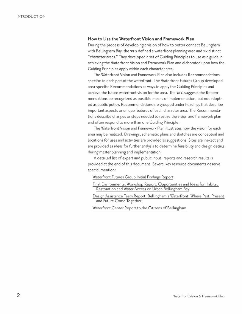
How to Use the Waterfront Vision and Framework PlanDuring the process of developing a vision of how to better connect Bellingham with Bellingham Bay, the wfg defined a waterfront planning area and six distinct “character areas.” They developed a set of Guiding Principles to use as a guide in achieving the Waterfront Vision and Framework Plan and elaborated upon how the Guiding Principles apply within each character area.
The Waterfront Vision and Framework Plan also includes Recommendations specific to each part of the waterfront. The Waterfront Futures Group developed area-specific Recommendations as ways to apply the Guiding Principles and achieve the future waterfront vision for the area. The wfg suggests the Recom-mendations be recognized as possible means of implementation, but not adopt-ed as public policy. Recommendations are grouped under headings that describe important aspects or unique features of each character area. The Recommenda-tions describe changes or steps needed to realize the vision and framework plan and often respond to more than one Guiding Principle.
The Waterfront Vision and Framework Plan illustrates how the vision for each area may be realized. Drawings, schematic plans and sketches are conceptual and locations for uses and activities are provided as suggestions. Sites are inexact and are provided as ideas for further analysis to determine feasibility and design details during master planning and implementation.
A detailed list of expert and public input, reports and research results is provided at the end of this document. Several key resource documents deserve special mention:
Waterfront Futures Group Initial Findings Report;
Final Environmental Workshop Report: Opportunities and Ideas for Habitat Restoration and Water Access on Urban Bellingham Bay;
Design Assistance Team Report: Bellingham’s Waterfront: Where Past, Present and Future Come Together;
Waterfront Center Report to the Citizens of Bellingham.
3Waterfront Futures Group Final Recommendations
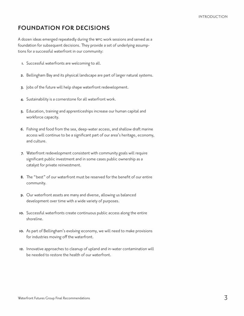
A dozen ideas emerged repeatedly during the wfg work sessions and served as a foundation for subsequent decisions. They provide a set of underlying assump-tions for a successful waterfront in our community:
1. Successful waterfronts are welcoming to all.
2. Bellingham Bay and its physical landscape are part of larger natural systems.
3. Jobs of the future will help shape waterfront redevelopment.
4. Sustainability is a cornerstone for all waterfront work.
5. Education, training and apprenticeships increase our human capital and workforce capacity.
6. Fishing and food from the sea, deep-water access, and shallow draft marine access will continue to be a significant part of our area’s heritage, economy, and culture.
7. Waterfront redevelopment consistent with community goals will require significant public investment and in some cases public ownership as a catalyst for private reinvestment.
8. The “best” of our waterfront must be reserved for the benefit of our entire community.
9. Our waterfront assets are many and diverse, allowing us balanced development over time with a wide variety of purposes.
10. Successful waterfronts create continuous public access along the entire shoreline.
10. As part of Bellingham’s evolving economy, we will need to make provisions for industries moving off the waterfront.
12. Innovative approaches to cleanup of upland and in-water contamination will be needed to restore the health of our waterfront.
FOUNDATION FOR DECISIONS
INTRODUCTION

long panoramas of delta and sand from the stack on the bluff to the dock
on the shore. a long natural beach.
a harbor for boats, a harbor to the bay. fishermen, mills and white tablecloth dining, our
port to the bay.
full of people, full of life! down to the water,
up to the town! living, working, gathering here!
long strands of park. stretching, connecting, people in the sun, people in
the rain from village to town.
the original village. bricks, books, the village green. kayaks, trains, ferries passing.
connecting islands up to the town!
still wild still green. here we bow down to the water.
a train whistle blows.
4 Waterfront Vision & Framework Plan
Little SqualicumThis area presents an outstanding opportunity for habitat and beach restoration. Future facilities on the bluff could be models of sustainable development and uses.
SqualicumFuture development could include a vibrant mixture of diverse facilities—housing, retail, office and public spaces throughout the area.
City CenterThis area could become an exciting mixture of housing, cultural facilities, waterfront access, public gathering places and waterfront activities.
The Cornwall Avenue landfill could include housing, open space, habitat restoration areas, public facilities and an overwater pathway connecting it to Boulevard Park and Fairhaven via the Taylor Avenue Dock.
South Hill & Boulevard ParkBoardwalks and improved beach access could become expansions of existing open space and trails, opening up additional recreational opportunities from Boulevard Park to Padden Creek.
FairhavenA direct connection from the Village Green to the shore would allow access to the water through and around the marine industrial area.
Chuckanut & EdgemoorCreating new kayak landings along the shore and a shoreline trail from Fairhaven and the Coast Millennium Trail could provide additional access for boaters.
WATERFRONT CHARACTER AREAS
INTRODUCTION

5Waterfront Futures Group Final Recommendations
INTRODUCTION
The planning area includes the Bellingham Bay waterfront between the Bellingham Urban Growth Area (just north of Cliffside Drive) on the north and Chuckanut Bay on the south. Moving from north to south, there are six areas of distinct character within the overall waterfront area:
Little SqualicumSqualicumCity CenterSouth Hill & Boulevard ParkFairhaven Chuckanut & Edgemoor

6 Waterfront Vision & Framework Plan
Reinforce the Inherent Qualities of Each Place on the Waterfront 1. Make the waterfront a regular part of the lives of more
people.
2. Respect history, cultures and the arts.
3. Make the waterfront inviting to people on foot.
4. Reinforce a unique “sense of place” at different waterfront locations.
5. Complement adjacent uses.
Restore the Health of Land & Water 1. Enhance or reintroduce natural systems.
2. Create and restore habitat wherever possible.
3. Remediate upland and in-water contamination.
4. Protect existing natural shorelines.
5. Seek opportunities to soften existing hardened shorelines.
6. Tailor environmental cleanup strategies and remediation to planned use.
7. Manage stormwater to enhance estuarine habitats.
8. Require sustainable practices in all development.
9. Restore, enhance and expand beaches wherever possible.
10. Connect proposed open space and natural areas to regional open space network and wildlife corridors.
11. Explore mitigation banking and incentives (such as environmental credits) for environmental resource protection and enhancement prior to redevelopment.
Improve Waterfront Access 1. Develop strong connections between uplands and water.
2. Provide links to regional trail systems.
3. Provide multiple modes of access to each area of the waterfront.
4. Provide convenient connections between different modes of transportation.
5. Create and connect large and small parks and open spaces with a “braided” system of pedestrian trails.
6. Enhance opportunities for visual access to waterfront areas.
7. Provide the opportunity to walk the waterfront while respecting natural habitat.
8. Help people find their way.
9. Provide way finding for the Coast Millennium Trail as a route that follows existing and proposed trails.
10. Explore the concept of public access “banking” and other financing incentives for improving public access.
11. Protect and enhance environmental resources when designing for shoreline access and upland development.
Promote a Healthy & Dynamic Waterfront Economy 1. Create new mixed-use areas on the waterfront for
commercial, industrial, educational, recreational and residential uses.
2. Support water-dependent activities and uses.
3. Create conditions attractive to jobs of the future.
4. Strengthen the tie between local jobs and resources.
5. Provide public amenities and infrastructure to support redevelopment.
6. Improve permitting processes to achieve the goals and principles of the Waterfront Vision.
7. Explore economic spin-off related to Bellingham Bay Pilot cleanup strategies.
8. Provide incentives and credits for “green” buildings.
The Waterfront Vision and Framework Plan provides four overarching principles and thirty-five detailed principles to guide progress toward achieving a successful waterfront. The Wa-terfront Futures Group recommends all thirty-nine Guiding Principles for adoption as public policy. In some cases, bulleted statements follow the Guiding Principle. These statements provide further detail and should be treated as part of the Guiding Principle for that area.
GUIDING PRINCIPLES AND RECOMMENDATIONS
INTRODUCTION
7Waterfront Futures Group Final Recommendations
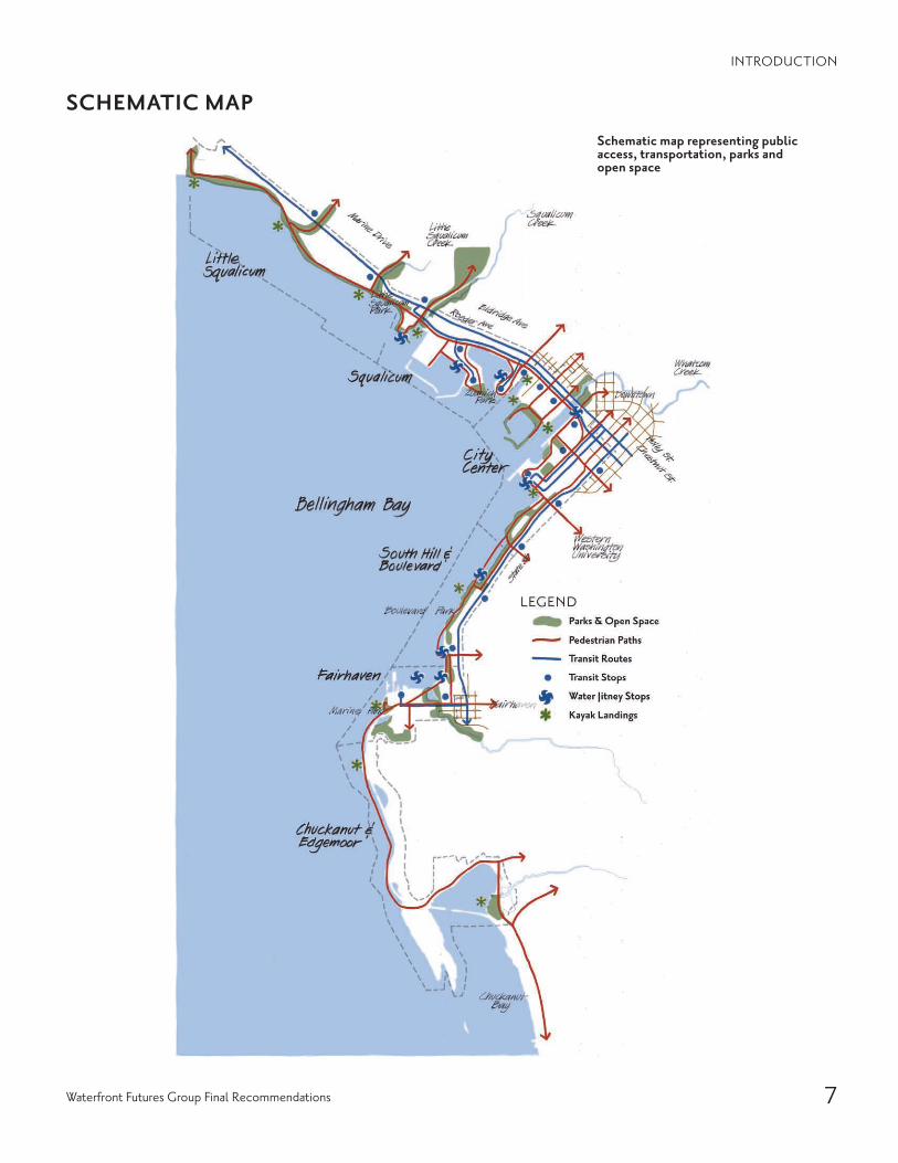
Schematic map representing public access, transportation, parks and open space
SCHEMATIC MAP
INTRODUCTION

8 Waterfront Vision & Framework Plan
LITTLE SQUALICUM
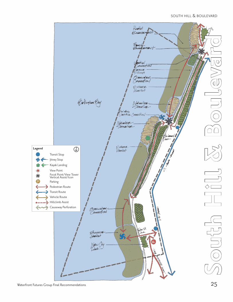
Legend
• Transit Stop
• r- litney Stop
• ~ Kayak Landing
* * Ci)
View Point Focal Point/View Tower Vertical Assist/Icon Parking
+(-~) Pedestrian Route
4(---)~ Transit Route
~(--)~ Vehicle Route
••••••~ HillclimbAssist
~ Causeway Perforation

9Waterfront Futures Group Final Recommendations
Litt
le S
qual
icum
the vision for little squalicum restores the natural beach and habitat, and preserves the largely deciduous tree-covered bluff and its connection to the landscape of the Nooksack River delta. Public ac-cess along the beach will be limited in favor of habitat restoration. Access to the beach will be improved
with trails that traverse the slope, connecting the beach with the bluff trail and connecting pedestrians to transit stops and parking along Marine Drive. The existing cement plant will be accommodated as long as it continues to operate, but new heavy industrial uses will be precluded. When the cement plant ceases
operation, the 50-acre site should be master planned for a mixture of uses, including light industrial, research and institutional uses. Existing landmark industrial buildings should be adaptively reused where possible, and the existing landmark smoke stack should be preserved. The emphasis should be on habitat restoration and enhancement rather than human use along the beach and bluff in Little Squalicum. Future de-velopment should be limited to the top of the bluff and be compatible in scale and density with surrounding residential development in the area.
Section looking west showing beach & habitat enhancement, site redevelopment, parking, transit stop, overlook & railroad crossing. (Concrete plant smokestack in the background.)
Belli
ngha
m B
ay
Nor
th B
ay T
rail
BNSF
Rai
lroad
Smok
esta
ckLa
ndm
ark
Ove
rlook
s
Tran
sit &
Bike
Rou
tes
Beach & Habitat Enhancement Light Industrial & Mixed-use
Redevelopment
0' 50'

10 Waterfront Vision & Framework Plan
LITTLE SQUALICUM
GUIDING PRINCIPLES
Reinforce the Inherent Qualities of Each Place on the Waterfront 1. Make the waterfront a regular part of the lives of more
people.
2. Respect history, cultures and the arts.· Identify historic sites prior to development· Embrace and expand knowledge of past heritage· Identify, locate and provide interpretative information
for native history, pioneer history and natural history
3. Make the waterfront inviting to people on foot.
4. Reinforce a unique “sense of place” at different water-front locations.· Protect the natural shoreline and bluff· Accommodate light industrial and encourage research
and institutional uses· Preserve landmark industrial structures · Preserve and enhance existing vegetation where possible · Preserve the native trees on the bluff and maintain
the soft, largely deciduous vegetated profile· Guide redevelopment of industrial areas to respect
the character of Little Squalicum· Continue to recognize the influence of Nooksack
River and river delta on character of Little Squalicum
5. Complement adjacent uses.· Preserve and protect the habitat function of the
adjacent beach and bluff
Restore the Health of Land & Water 1. Enhance or reintroduce natural systems.
· Preserve and enhance the natural beach and restore onshore and offshore habitat
· Incorporate coastal geology and other natural forces in inter-tidal habitat and beach enhancement
2. Create and restore habitat wherever possible.· Give priority to habitat restoration and preservation
both on the beach and in the tidelands · Limit access in favor of habitat protection
3. Remediate upland and in-water contamination.
4. Protect existing natural shorelines.· Recognize the dynamic nature of changing tidelands
from Nooksack River sediments
5. Seek opportunities to soften existing hardened shorelines.
6. Tailor environmental cleanup strategies and remediation to planned use.
7. Manage stormwater to enhance estuarine habitats.
· Treat, or otherwise assure the quality of, stormwater used to enhance estuarine habitats
8. Require sustainable practices in all development.· Favor plans which exploit adaptive reuse of existing
cement plant structures· Remediate existing contamination while establishing
erosion control· Address creosoted pier pilings
9. Restore, enhance and expand beaches wherever possible.
10. Connect proposed open space and natural areas to regional open space network and wildlife corridors.· Tie the Squalicum natural system to the Nooksack
River riparian corridors and upland conservancy areas
11. Explore mitigation banking and incentives (such as environmental credits) for environmental resource protection and enhancement prior to redevelopment.
Improve Waterfront Access 1. Develop strong connections between uplands and water.
· Improve vehicular access and circulation, and provide shared decentralized parking away from the shoreline
2. Provide links to regional trail systems.
3. Provide multiple modes of access to each area of the waterfront.· Accommodate hand-carry boats on the beach at trail
connections· Create trails to link transit stops and parking areas
with viewpoints, the bluff trail, the beach and hand-carry boat landings
4. Provide convenient connections between different modes of transportation.
5. Create and connect large and small parks and open spaces with a “braided” system of pedestrian trails.· Provide large and small open spaces along the waterfront
to serve as connecting nodes for trails and “shoreways
6. Enhance opportunities for visual access to waterfront areas.
7. Provide the opportunity to walk the waterfront while respecting natural habitat.
8. Help people find their way.
9. Provide way finding for the Coast Millennium Trail as a route that follows existing and proposed trails.
10. Explore the concept of public access “banking” and other financing incentives for improving public access.
11. Protect and enhance shoreline environment when de-signing for shoreline access and upland development.

11Waterfront Futures Group Final Recommendations
LITTLE SQUALICUM
Promote a Healthy & Dynamic Waterfront Economy 1. Create new mixed-use areas on the waterfront for
commercial, industrial, educational, recreational and residential uses.· Support existing, viable, non-polluting industrial uses· Assist with long term transition strategy for heavy
industrial uses· Link technical institutions with training for new forms
of employment· Extend and expand upon existing industry and commerce· Integrate commerce and new industry with training
and education facilities
2. Support water-dependent activities and uses.· Provide transition and relocation of non water-depen-
dent heavy industrial and commercial waterfront uses
3. Create conditions attractive to jobs of the future.
4. Strengthen the tie between local jobs and resources.
5. Provide public amenities and infrastructure to support redevelopment.
6. Improve permitting processes to achieve the goals and principles of the Waterfront Vision.· Anticipate redevelopment of upland industrial prop-
erty by providing appropriate infrastructure, design guidelines, zoning and permitting processes
7. Explore economic spin-off related to Bellingham Bay Pilot cleanup strategies.
8. Provide incentives and credits for “green” buildings.
RECOMMENDATIONS
Culture & History
· Collaborate with Native American neighbors.
· Provide interpretative information about the Lummi Nation, Nooksack River and Old Fort Bellingham.
· Preserve the natural beach and maintain it as public open space and restored habitat.
Restoration & Natural Habitat
· Remove wood-chip debris along the beach.
· Replace or remediate creosoted pilings at cement plant dock.
· Monitor Little Squalicum Creek and uplands and reme-diate as appropriate.
Cement Plant Area
· Research existing condition and potential future public uses of cement plant dock.
· Accommodate the existing cement plant until it closes, and preclude new heavy industrial uses.
· When the cement plant ceases operation, prepare a master plan for the site that accommodates a mixture of uses compatible with surrounding low density resi-dential development.
· Consider preservation of landmark industrial structures, such as the smoke stack, as redevelopment occurs.
Connections & Transportation
· Link green spaces to other green corridors along the river, on the Lummi Reservation and wetlands adjacent to the airport.
· Link the Coast Millennium Trail and the North Bay Trail.
· Create a trail along the bluff with views out to the water.
· Develop trail connections between the beach and uplands using existing grade separation opportunities for crossing beneath the railroad.
· Design way-finding system into and out of Little Squalicum.
· Evaluate approaches for parking options close to Little Squalicum Beach Park.
· Create small parking areas along Marine Drive at trailheads.
· Designate bicycle routes along Roeder Avenue and Marine Drive.
· Locate transit stops at trail heads on Marine Drive.
Future Development & Open Space
· Establish clear and definitive design and development guidelines for new development on the bluff.
· Encourage adaptive reuse of existing buildings.
· Preserve existing and create new public viewpoints along the bluff trail and at trailheads.
· Cluster mixture of uses on the bluff buffered from adja-cent residential areas.
· Cluster new development on the uplands with green buffers.

12 Waterfront Vision & Framework Plan
squalicum is a place that supports industry, working boats and pleasure craft, along with places to walk, sit and enjoy water views. The vision for Squalicum builds upon and reinforces this character. Water-related industrial uses will continue around the Squalicum Waterway, and marina-related activities will continue to be predominate around the inner and outer harbor. Over time, maritime uses will be diversified and the existing parking and marina support-area will gradually transition to a mixture of light industrial, commercial and residential uses. The Bellwether Peninsu-
SQUALICUM

13Waterfront Futures Group Final Recommendations
Squa
licu
mla will be further developed with retail and visitor support services along with some housing. Marine habitat will be recreated at the mouth of Squalicum Creek, and along existing marina breakwaters. Public access to the water and around Squalicum will be enhanced with improved trails, new viewpoints and improved transit. Squalicum will be a diverse center of maritime activity, and a place that welcomes residents, workers and visitors alike.
View to the south from Broadway Overlook showing new pedestrian overpass connecting to Bellwether peninsula.

14 Waterfront Vision & Framework Plan
Aerial view looking east showing mixed-use development, existing marina and potential new marina (lower right).
SQUALICUM
GUIDING PRINCIPLES
Reinforce the Inherent Qualities of Each Place on the Waterfront 1. Make the waterfront a regular part of the lives of more
people.· Welcome visitors (coming by water or land)
2. Respect history, cultures and the arts.· Devise a process of engagement with Native history· Embrace, include and expand upon knowledge of
cultural and historical past
3. Make the waterfront inviting to people on foot.· Establish clear and definitive design and develop-
ment guidelines
4. Reinforce a unique “sense of place” at different water-front locations.· Support transition and re-use of centralized surface
parking areas· Nurture diversity of water-oriented activities by in-
cluding a mixture of light industrial, commercial and residential uses
· Establish view preservation guidelines
5. Complement adjacent uses.
15Waterfront Futures Group Final Recommendations
4. Provide convenient connections between different modes of transportation (jitney/bus).
5. Create and connect large and small parks and open spaces with a “braided” system of pedestrian trails.
6. Enhance opportunities for visual access to waterfront areas and activities.
7. Provide the opportunity to walk the waterfront while respecting natural habitat.· Provide viewing that respects industrial activity areas
8. Help people find their way.
9. Provide way finding for the Coast Millennium Trail as a route that follows existing and proposed trails.
10. Explore the concept of public access “banking” and other financing incentives for improving public access.
11. Protect and enhance shoreline environmental resourc-es when designing for shoreline access and upland development.
Promote a Healthy & Dynamic Waterfront Economy 1. Create new mixed-use areas on the waterfront for
commercial, industrial, educational, recreational and residential uses.
2. Support water-dependent activities and uses.
3. Create conditions attractive to jobs of the future.
4. Strengthen the tie between local jobs and resources.
5. Provide public amenities and infrastructure to support redevelopment.
6. Improve permitting processes to achieve the goals and principles of the Waterfront Vision.
7. Explore economic spin-off related to Bellingham Bay Pilot cleanup strategies.
8. Provide incentives and credits for “green” buildings.
SQUALICUM
Restore the Health of Land & Water 1. Enhance or reintroduce natural systems.
2. Create and restore habitat wherever possible.
3. Remediate upland and in-water contamination.
4. Protect existing natural shorelines.
5. Seek opportunities to soften existing hardened shorelines.
6. Tailor environmental cleanup strategies and remedia-tion to planned use.
7. Manage stormwater to enhance estuarine habitats.· Treated or otherwise, assure the quality of stormwa-
ter used to enhance estuarine habitats
8. Require sustainable practices in all development.· Establish and enforce a groundwater and contami-
nation collection and treatment plan to prevent contaminates from entering the bay
· Use building materials which do not produce toxics, i.e. avoid copper roofs
· Reduce “heat island” effect by selecting light colored paving materials and/or use open grid surface systems
9. Restore, enhance and expand beaches wherever possible.
10. Connect proposed open space and natural areas to regional open space network and wildlife corridors.
11. Explore mitigation banking and incentives (such as environmental credits) for environmental resource protection and enhancement prior to redevelopment.
Improve Waterfront Access 1. Develop strong connections between uplands and water.
2. Provide links to regional trail systems.· As redevelopment occurs, maintain waterside trails
3. Provide multiple modes of access to each area of the waterfront.· Provide large and small open spaces along the waterfront
to serve as connecting nodes for trails and “shoreways”· Locate dry stack storage and boat trailer parking away
from the water

View from water toward Mt. Baker Plywood showing new incubabutor businesses, public park, creek realignment and habitat restoration.
16 Waterfront Vision & Framework Plan
RECOMMENDATIONS
Future Development
· Cluster industrial activity around the south side and east end of Squalicum Creek Waterway.
· Reinforce the use of Squalicum Parkway as a means of pedestrian, vehicular and rail access to the waterfront.
· At the south end of the Mount Baker Plywood site, cre-ate an area for light industry including opportunity for start-up businesses.
· Support transition of some surface parking areas to a denser mix of maritime-related and marina support functions including structured or decentralized parking, commercial uses and potentially housing.
· Add new employment and living opportunities to exist-ing maritime support areas as part of new mixed-use development.
· Create a focal point for charters, excursion craft, etc.
· Maintain a fishing and commercial charter boat center near a public dock in the outer harbor.
· Develop an area to buy seafood from providers.
· Investigate providing a small vessel boatlift to support inland dry stack storage and to replace existing launch ramp at the inner harbor.
· Create denser, mixed-use development along Roeder Avenue and along the east end of the site and on Bell-wether Peninsula.
· Establish and locate in the Squalicum area an activity hub that might include eco-tourism, recreation, bike facilities, a hostel, and an interpretive center as part of extending a welcome to visitors.
· Establish design guidelines that provide for varied heights of structures, preserve important public views, create opportu-nities for new public views, and consider existing character as a metaphor for new development.
· Encourage mixed-use development with design guidelines that are consistent with the character of Squalicum.
· Cluster related products and uses.
Connections & Trails
· Extend pathway westward along Roeder Avenue to the Squalicum Creek Waterway and Little Squalicum Park.
· Extend pathway around Mount Baker Plywood to provide access to open space at the south end of the peninsula.
· Extend pathway along east side of Mount Baker Plywood to a new overlook adjacent to the Squalicum estuary.
· Re-examine the role of the Broadway corridor as a boulevard and support redesign that is more pedestrian friendly, retaining street trees and setback sidewalk.
· Construct a pedestrian bridge over Roeder Avenue and the railroad to connect the neighborhood on the bluff with the waterfront along the Broadway Street align-ment and connect the bridge to a vertical building with opportunities for views of the water.
· Provide water jitney stops at the south side of Mount Baker Plywood peninsula, the public dock in the outer harbor and at the end of the Bellwether Peninsula.
· Create transit routes for on demand service to the Bellwether Peninsula and along Coho Way.
· Provide a hand-carry boat landing on the west side of Squalicum Creek Waterway.
· Focus large truck access on Squalicum Parkway and improve access to I-5 at Guide Meridian.
· Improve Seaview Avenue as a vehicular and pedestrian route from Eldridge Avenue to the waterfront.
· Retain and enhance the existing shore side path system throughout Squalicum Marina area.
SQUALICUM
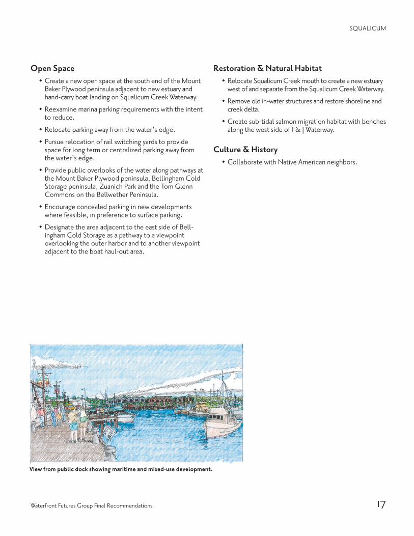
View from public dock showing maritime and mixed-use development.
17Waterfront Futures Group Final Recommendations
Open Space
· Create a new open space at the south end of the Mount Baker Plywood peninsula adjacent to new estuary and hand-carry boat landing on Squalicum Creek Waterway.
· Reexamine marina parking requirements with the intent to reduce.
· Relocate parking away from the water’s edge.
· Pursue relocation of rail switching yards to provide space for long term or centralized parking away from the water’s edge.
· Provide public overlooks of the water along pathways at the Mount Baker Plywood peninsula, Bellingham Cold Storage peninsula, Zuanich Park and the Tom Glenn Commons on the Bellwether Peninsula.
· Encourage concealed parking in new developments where feasible, in preference to surface parking.
· Designate the area adjacent to the east side of Bell-ingham Cold Storage as a pathway to a viewpoint overlooking the outer harbor and to another viewpoint adjacent to the boat haul-out area.
Restoration & Natural Habitat
· Relocate Squalicum Creek mouth to create a new estuary west of and separate from the Squalicum Creek Waterway.
· Remove old in-water structures and restore shoreline and creek delta.
· Create sub-tidal salmon migration habitat with benches along the west side of I & J Waterway.
Culture & History
· Collaborate with Native American neighbors.
SQUALICUM

18 Waterfront Vision & Framework Plan
CITY CENTER
the vision for the city center waterfront calls for the creation of a mixed-use neighborhood that combines com-mercial, institutional, educational, retail services and residen-tial uses, and that over time will provide many new job oppor-tunities and a substantial amount of urban housing. It will be a neighborhood that complements the existing central business district. The neighborhood will provide a place where people can live, work, study and spend their leisure time without relying on vehicular transportation and while offering a healthy and sustainable relationship between the city and the bay.
The existing aeration stabilization basin (asb) will be cleaned and opened up to accommodate either a new marina or new marine habitat combined with stormwater treatment or some combination of those uses. When the adjacent tissue warehouse closes, the building will be adapted to accommo-date a combination of public uses with links to Old Town.
Deep water moorage will be maintained in the Whatcom Waterway and marine-related commerce will continue on both the I & J and Whatcom Waterways. The waterways will retain sufficient depth to support existing and planned shore-side uses. Public access will be provided throughout the
area, with a network of walkways connecting new public spaces and regional trails. Transient moorage will be provided on both sides of the Whatcom Creek Waterway while avoiding critical habitat areas. Habitat enhancement will be a condi-tion of this new transient moorage provision. New transit routes will serve the area and public docks will accommodate multiple modes of water transportation.
New facilities for Western Washington University and other educational institutions will be located in the Center City area with new transportation linkages to the main wwu campus. The Cornwall Avenue landfill site will be improved including open space and pedestrian spaces along the waters edge connected by an over-water trail to Boulevard Park. Mixed-use develop-ment on the adjacent uplands could include a terraquarium and a Native American facility.
To realize this vision, the Georgia Pacific property should be acquired and held in public ownership as it is planned and developed over time. Infrastructure and public amenities to support development should be constructed, and develop-ment should be phased and coordinated by a public renewal authority or other tools that ensure public accountability while
avoiding excess bureaucracy.
Bird’s-eye view showing a mixed-use neighborhood combining commercial, institutional, educational, retail services and residential uses.

19Waterfront Futures Group Final Recommendations
City Center

20 Waterfront Vision & Framework Plan
CITY CENTER
GUIDING PRINCIPLES
Reinforce the Inherent Qualities of Each Place on the Waterfront 1. Make the waterfront a regular part of the lives of more
people.· Foster a greater sense of ownership and stewardship
for the health of the Bay and its shore lands by pro-viding places for people to live, work, learn and play as a regular part of their daily activities
· Create physical and cultural conditions that are wel-coming to visitors and encourage their participation in waterfront places and activities
2. Respect history, cultures and the arts.· Embrace, include and expand knowledge of our
peoples and their cultural heritage
3. Make the waterfront inviting to people on foot.
4. Reinforce a unique “sense of place” at different water-front locations.· Support development of a vibrant area that integrates wa-
ter-dependent uses with new commercial, institutional, educational, and residential uses and public spaces
5. Complement adjacent uses.· Create an urban mixed-use neighborhood that will
complement downtown
Restore the Health of Land & Water 1. Enhance or reintroduce natural systems.
2. Create and restore habitat wherever possible.
3. Remediate upland and in-water contamination.
4. Protect existing natural shorelines.
5. Seek opportunities to soften existing hardened shorelines.
6. Tailor environmental cleanup strategies and remedia-tion to planned use.
7. Manage stormwater to enhance estuarine habitats.· Treated or otherwise, assure the quality
of stormwater used to enhance estuarine habitats.
8. Require sustainable practices in all develop-ment.· Avoid “heat island” effect by utilizing high
reflective roofing materials and vegetated roof systems
· Make use of on-site renewable energy such as solar and daylighting, to satisfy the building’s energy needs
· Incorporate Leadership in Energy & Environmental Design (leed) intentions and requirements in design and construction of new structures
9. Restore, enhance and expand beaches wherever possible.
10. Connect proposed open space and natural areas to re-gional open space network and natural wildlife corridors.
11. Explore mitigation banking and incentives (such as envi-ronmental credits) for environmental resource protec-tion and enhancement prior to redevelopment.
Improve Waterfront Access 1. Develop strong connections between uplands and water.
· Utilize existing streets to make pedestrian and ve-hicle connections to and from adjacent districts and neighborhoods
· Identify areas where pedestrian access is provided when not in use for commercial/industrial purposes
· Provide transient moorage with easy access from water to upland services
2. Provide links to regional trail systems.
3. Provide multiple modes of access to each area of the waterfront.· Create and establish circulation routes· Preserve transportation corridor on railroad right-of-way · Cluster shared parking away from the water
4. Provide convenient connections between different modes of transportation (jitney/bus).
Section looking northeast (Whatcom Creek Waterway on left, Railroad Avenue on right)
Wha
tcom
Cre
ek W
ater
way
Publ
ic W
harf
&Tr
ansit
ent M
oora
ge
Cor
nwal
l Ave
nue
Railr
oad
Aven
ue
Mixed-use RedevelopmentLaurel Street
Overpass
Parking structure against
bluff
0' 50'
bnsf
Rai
lroad
relo
cate
d ag
ains
t blu
ff

21Waterfront Futures Group Final Recommendations
CITY CENTER
View along Whatcom Creek Waterway looking toward downtown, with transient moorage, mixed-use development.
5. Create and connect large and small parks and open spaces with a “braided” system of pedestrian trails.· Create water-oriented parks and open spaces· Connect parks and open spaces with walkways and
bikeways through the City Center neighborhood
6. Enhance opportunities for visual access to waterfront areas.· Preserve, improve and create public views to and
from the waterfront
7. Provide the opportunity to walk the waterfront while respecting natural habitat.· Provide viewing that respects industrial activity areas
8. Help people find their way.
9. Provide way finding for the Coast Millennium Trail as a route that follows existing and proposed trails.
10. Explore the concept of public access “banking” and other financing incentives for improving public access.
11. Protect and enhance shoreline environmental resources when designing for shoreline access and upland devel-opment.
Promote a Healthy & Dynamic Waterfront Economy 1. Create new mixed-use areas on the waterfront for
commercial, industrial, educational, recreational and residential uses.· Encourage reuse and renovation of existing buildings· Identify, preserve and locate sites for water-depen-
dent uses· Complement existing downtown area with water-
front redevelopment· Support water-dependent activities and uses· Retain deep water moorage and entitlement
2. Support water-dependent activities and uses.
3. Create conditions attractive to jobs of the future.· Create a vision for desired businesses and educa-
tional facilities
4. Strengthen the tie between local jobs and resources.· Encourage and promote fisheries and ocean-related
research industries and facilities· Encourage a range of development and businesses
that foster apprenticeships and other educational and training opportunities
5. Provide public amenities and infrastructure to support redevelopment.
6. Improve permitting processes to achieve the goals and principles of the Waterfront Vision.· Promote a “business incuba-
tor” model with access to development resources
· Create flexible zoning in the City Center
7. Explore economic spin-off related to Bellingham Bay Pilot cleanup strategies.
8. Provide incentives and credits for “green” buildings.

22 Waterfront Vision & Framework Plan
CITY CENTER
RECOMMENDATIONS
Future Uses
· When the Georgic Pacific tissue plant closes, use the site of the tissue warehouse for a combination of public uses which could include neighborhood gathering places, community facilities, sites for dry stack boat stor-age and support facilities for a new marina at the asb site.
· Provide sites for water-dependent uses along both the I & J Waterway and the Whatcom Creek Waterway on either side of the asb peninsula.
· Create beach areas with small parking lots on either side of the asb site and at the end of Wharf Street adja-cent to the Cornwall Landfill.
· Relocate rail road tracks from the Georgic Pacific site to the base of the bluff.
· To cluster shared parking away from the water, consider locating public parking to buffer development areas from the railroad and the Co-Gen plant.
Future Development
· Provide a site for Western Washington University expan-sion at the foot of Pine Street and the water’s edge.
· Provide for a range of education and research facilities.
· Retain sufficient water depth in I & J and Whatcom water-ways to support existing and future water-related uses.
· Create a public renewal authority or use other methods to develop a plan for the City Center area and to coordinate its implementation.
· Purchase the Georgia Pacific site and put it in public ownership to assure that the long term community interest is served.
· Create expedited review and permitting procedures for redevelopment that is consistent with an adopted renewal plan.
· Provide a location for a potential terraquarium as well as other potential cultural facilities.
· Provide an enhanced beach at the north end of the site, and locations for a potential terraquarium as well as a potential Native American cultural facility.
· Coordinate with the Economic Development Council to publicize local resources and maximize use of locally based contractors.
· Accommodate mixed-use development on uplands adjacent to Cornwall Avenue landfill site.
· Along Whatcom Waterway water-related commercial/industrial development may incorporate some residen-tial components.
Natural Systems & Environmental Cleanup
· Clean up contamination outside of the asb on the bay side.
· Remove all contaminated sediment from the asb and reconnect with Bellingham Bay.
· Examine implications of leaving the Whatcom Water-way sediment in place.
· Remove creosote piles from intertidal and subtidal areas near RG Haley site.
· Protect habitat enhancements at the log pond site and extend habitat and beach enhancement into upland areas.
· Cap the Cornwall Avenue landfill and provide marine habitat enhancement and a new public open space along the water for the length of the site.
· Examine contamination levels to help shape renewal master plan and then tailor remediation to planned use.
· Restore beaches where possible.
· Investigate opportunities for stormwater treatment and creation of marsh habitat using treated stormwater at outfalls and adjacent to open space areas.
Culture & History
· Collaborate with Native American neighbors.
· Preserve the train depot building off Holly Street.
Section looking northeast (Cornwall landfill on the left, State Street on the right)
Belli
ngha
m B
ay
Inte
rurb
an T
rail
Stat
e St
reet
Shor
elin
e En
hanc
emen
ts
(sof
t & h
ard
edge
s)
Open Space & Public Park Parking against bluff
0' 50'
Wave Energy Buffer — Fill with Eel Grass
bnsf
Rai
lroad
23Waterfront Futures Group Final Recommendations
CITY CENTER
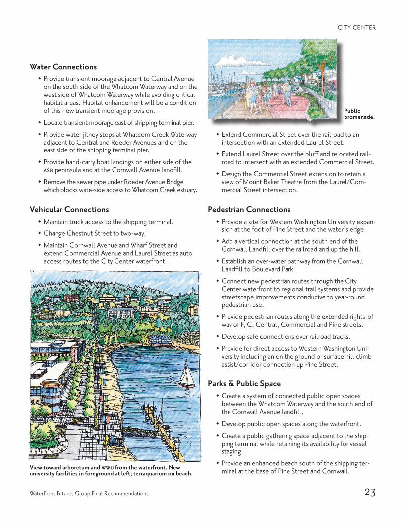
View toward arboretum and wwu from the waterfront. New university facilities in foreground at left; terraquarium on beach.
Water Connections
· Provide transient moorage adjacent to Central Avenue on the south side of the Whatcom Waterway and on the west side of Whatcom Waterway while avoiding critical habitat areas. Habitat enhancement will be a condition of this new transient moorage provision.
· Locate transient moorage east of shipping terminal pier.
· Provide water jitney stops at Whatcom Creek Waterway adjacent to Central and Roeder Avenues and on the east side of the shipping terminal pier.
· Provide hand-carry boat landings on either side of the asb peninsula and at the Cornwall Avenue landfill.
· Remove the sewer pipe under Roeder Avenue Bridge which blocks wate-side access to Whatcom Creek estuary.
Vehicular Connections
· Maintain truck access to the shipping terminal.
· Change Chestnut Street to two-way.
· Maintain Cornwall Avenue and Wharf Street and extend Commercial Avenue and Laurel Street as auto access routes to the City Center waterfront.
· Extend Commercial Street over the railroad to an intersection with an extended Laurel Street.
· Extend Laurel Street over the bluff and relocated rail-road to intersect with an extended Commercial Street.
· Design the Commercial Street extension to retain a view of Mount Baker Theatre from the Laurel/Com-mercial Street intersection.
Pedestrian Connections
· Provide a site for Western Washington University expan-sion at the foot of Pine Street and the water’s edge.
· Add a vertical connection at the south end of the Cornwall Landfill over the railroad and up the hill.
· Establish an over-water pathway from the Cornwall Landfill to Boulevard Park.
· Connect new pedestrian routes through the City Center waterfront to regional trail systems and provide streetscape improvements conducive to year-round pedestrian use.
· Provide pedestrian routes along the extended rights-of-way of F, C, Central, Commercial and Pine streets.
· Develop safe connections over railroad tracks.
· Provide for direct access to Western Washington Uni-versity including an on the ground or surface hill climb assist/corridor connection up Pine Street.
Parks & Public Space
· Create a system of connected public open spaces between the Whatcom Waterway and the south end of the Cornwall Avenue landfill.
· Develop public open spaces along the waterfront.
· Create a public gathering space adjacent to the ship-ping terminal while retaining its availability for vessel staging.
· Provide an enhanced beach south of the shipping ter-minal at the base of Pine Street and Cornwall.
Public promenade.
24 Waterfront Vision & Framework Plan
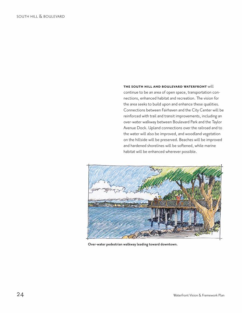
the south hill and boulevard waterfront will continue to be an area of open space, transportation con-nections, enhanced habitat and recreation. The vision for the area seeks to build upon and enhance these qualities. Connections between Fairhaven and the City Center will be reinforced with trail and transit improvements, including an over-water walkway between Boulevard Park and the Taylor Avenue Dock. Upland connections over the railroad and to the water will also be improved, and woodland vegetation on the hillside will be preserved. Beaches will be improved and hardened shorelines will be softened, while marine habitat will be enhanced wherever possible.
Over-water pedestrian walkway leading toward downtown.
SOUTH HILL & BOULEVARD
25Waterfront Futures Group Final Recommendations
SOUTH HILL & BOULEVARD
Sout
h H
ill &
Bou
leva
rd
26 Waterfront Vision & Framework Plan
SOUTH HILL & BOULEVARD
9. Restore, enhance and expand sand and gravel beaches wherever possible.
10. Connect proposed open space and natural areas to regional open space network and wildlife corridors.
11. Explore mitigation banking and incentives (such as environmental credits) for environmental resource protection and enhancement prior to redevelopment.
Improve Waterfront Access 1. Develop strong connections between uplands and water.
· Reinforce connections between Fairhaven and City Center
2. Provide links to regional trail systems.
3. Provide multiple modes of access to each area of the waterfront.· Create small parking areas at the upland side of
pedestrian routes to the water
4. Provide convenient connections between different modes of transportation (jitney/bus).
5. Create and connect large and small parks and open spaces with a “braided” system of pedestrian trails.· Expand upon the recreation activity at existing parks· Enhance existing open spaces· Promote opportunities for recreation
6. Enhance opportunities for visual access to waterfront areas.
7. Provide the opportunity to walk the waterfront while respecting natural habitat.
8. Help people find their way.
9. Provide way finding for the Coast Millennium Trail as a route that follows existing and proposed trails.
10. Explore the concept of public access “banking” and other financing incentives for improving public access.
11. Protect and enhance shoreline environmental resources when designing for shoreline access and upland devel-opment.
GUIDING PRINCIPLES
Reinforce the Inherent Qualities of Each Place on the Waterfront 1. Make the waterfront a regular part of the lives of more
people.
2. Respect history, cultures and the arts.· Embrace, include and expand upon knowledge of
cultural and historical past
3. Make the waterfront inviting to people on foot.· Improve existing and develop new pedestrian con-
nections between the neighborhoods on the bluff and the water
4. Reinforce a unique “sense of place” at different water-front locations.· Preserve the sense of forested continuity along the
hillside to the water
5. Complement adjacent uses.
Restore the Health of Land & Water 1. Enhance or reintroduce natural systems.
· Expand on the habitat restoration along the shoreline· Expand and enhance eelgrass beds along the near shore
2. Create and restore habitat wherever possible.
3. Remediate upland and in-water contamination.
4. Protect existing natural shorelines.
5. Seek opportunities to soften existing hardened shorelines.
6. Tailor environmental cleanup strategies and remedia-tion to planned use.
7. Manage stormwater retention and treatment to en-hance estuarine habitats.· Treated or otherwise, assure the quality of stormwa-
ter used to enhance estuarine habitats
8. Require sustainable practices in all development.· Continue using non-polluting structural materials in
over-water path construction · Utilize native plants and water efficient landscaping · Promote non-vehicle transportation
27Waterfront Futures Group Final Recommendations
RECOMMENDATIONS
Culture & History
· Collaborate with Native American neighbors.
· Conduct an inventory to identify all the historic and native sites.
Connections
· Construct an over-water trail to connect Boulevard Park to the Cornwall Landfill similar to the over water con-nection from Boulevard Park to Taylor Avenue Dock.
· Provide transit stops along State Street at waterfront trail connections.
· Improve a hand-carry boat landing area at Boulevard Park.
· Introduce more native plants in the park.
· Create water jitney stops at the north end of Boulevard Park and at the Taylor Avenue Dock.
· Create parking improvements along 10th Street.
· Designate a bike path between City Center and Fairhaven.
· Increase pedestrian corridors up the hill particularly between South Hill/Western neighborhoods and the waterfront.
SOUTH HILL & BOULEVARD
Natural Systems & Restoration
· Maintain separation between public access trails and the water’s edge to protect land and water habitat areas from the south end of Cornwall Landfill to the north end of Boulevard Park.
· Remove creosote piling along shoreline between Boulevard Park and Cornwall Landfill.
· Reduce some of the grassy areas and hardened edges to create a more naturalized transition from grass to native plants, and native plants to beach.
· Recreate eelgrass beds along and near the shore.
Future Uses
· Implement plans for the new park on city property south of the Taylor Avenue Dock and for the Floating Dock.
· Allow leases for food and beverage businesses that are appropriate to a pedestrian environment in the park.
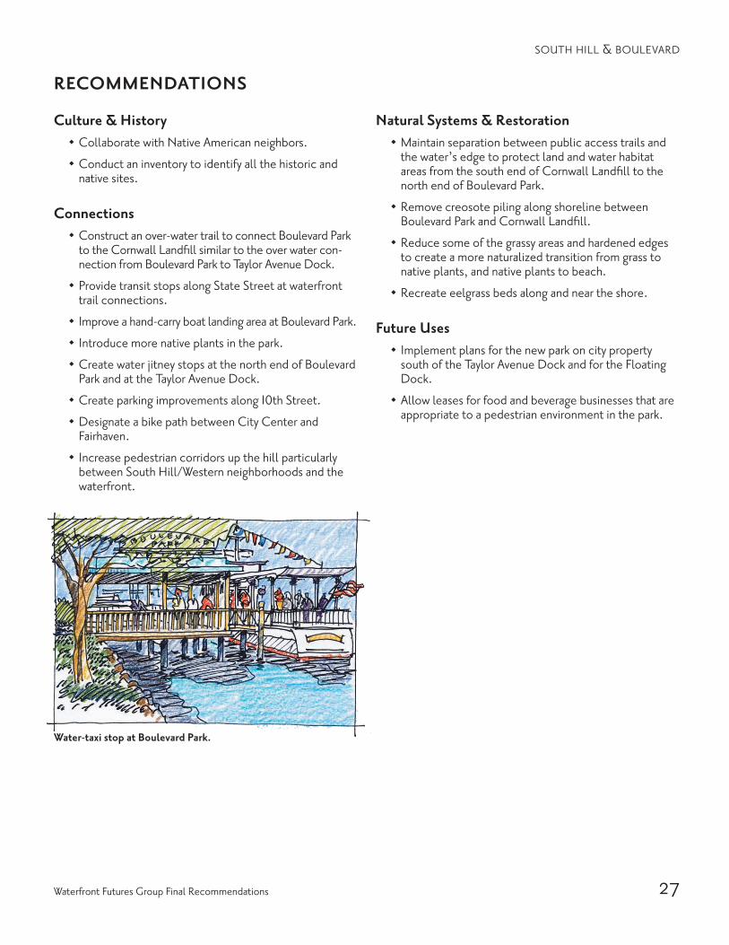
Water-taxi stop at Boulevard Park.
28 Waterfront Vision & Framework Plan
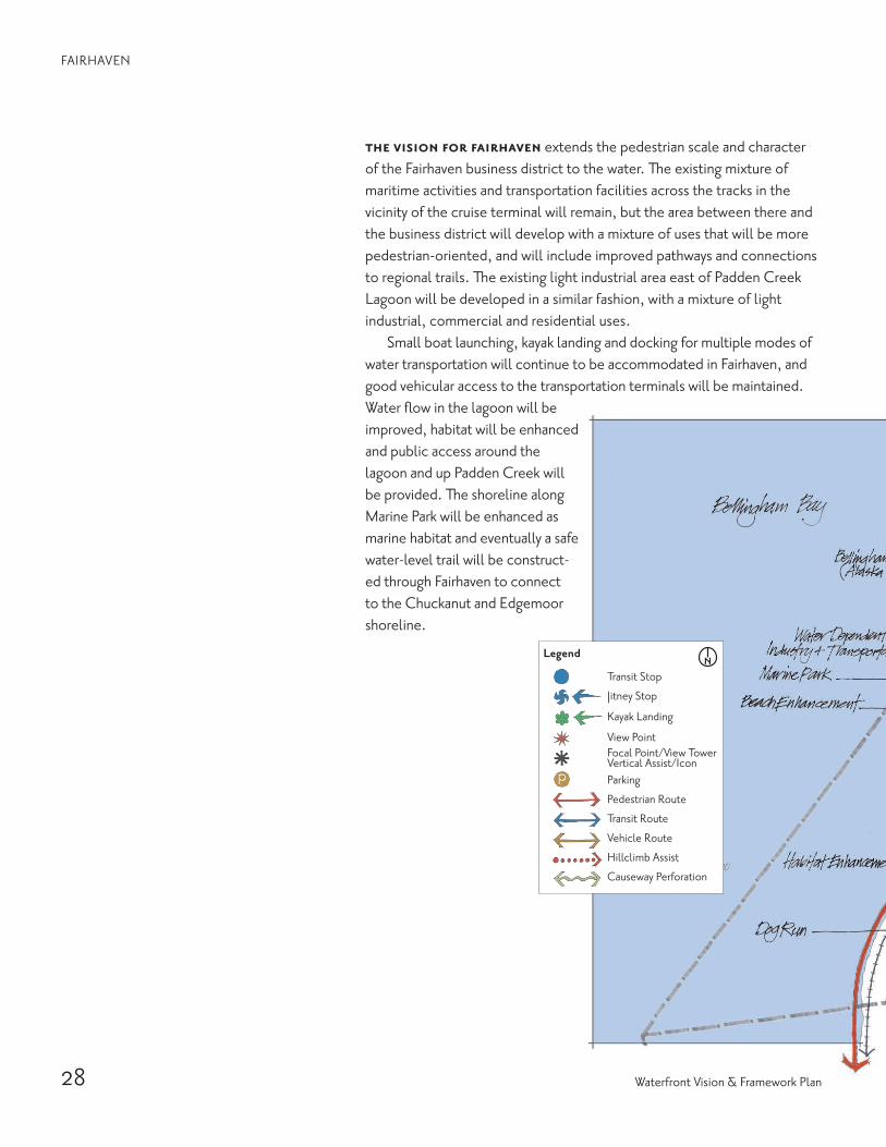
the vision for fairhaven extends the pedestrian scale and character of the Fairhaven business district to the water. The existing mixture of maritime activities and transportation facilities across the tracks in the vicinity of the cruise terminal will remain, but the area between there and the business district will develop with a mixture of uses that will be more pedestrian-oriented, and will include improved pathways and connections to regional trails. The existing light industrial area east of Padden Creek Lagoon will be developed in a similar fashion, with a mixture of light industrial, commercial and residential uses.
Small boat launching, kayak landing and docking for multiple modes of water transportation will continue to be accommodated in Fairhaven, and good vehicular access to the transportation terminals will be maintained. Water flow in the lagoon will be improved, habitat will be enhanced and public access around the lagoon and up Padden Creek will be provided. The shoreline along Marine Park will be enhanced as marine habitat and eventually a safe water-level trail will be construct-ed through Fairhaven to connect to the Chuckanut and Edgemoor shoreline.
FAIRHAVEN

29Waterfront Futures Group Final Recommendations
Fair
have
n
FAIRHAVEN

30 Waterfront Vision & Framework Plan
GUIDING PRINCIPLES
Reinforce the Inherent Qualities of Each Place on the Waterfront 1. Make the waterfront a regular part of the lives of more
people.
2. Respect history, cultures and the arts.· Embrace, include and expand knowledge of cultural past
3. Make the waterfront inviting to people on foot.· Accommodate transportation routes with minimum
disruption to pedestrian character
FAIRHAVEN
View from water of mixed-use development & park redevelopment with pedestrian connection to Fairhaven business district & the Village Green.
4. Reinforce a unique “sense of place” at different water-front locations.· Support the continuation of water and industry-de-
pendant uses· Promote a balanced mix of commercial, retail,
housing, light industry, marine-related businesses, transportation facilities and recreation
· Enhance open spaces
5. Complement adjacent uses.

31Waterfront Futures Group Final Recommendations
7. Provide the opportunity to walk the waterfront while respecting natural habitat.· Provide viewing that respects industrial activity areas
8. Provide safe viewing of industrial activity.
9. Help people find their way.
10. Provide way finding for the Coast Millennium Trail as a route that follows existing and proposed trails.
11. Explore the concept of public access “banking” and other financing incentives for improving public access.
12. Protect and enhance shoreline environmental resourc-es when designing for shoreline access and upland development.
Promote a Healthy & Dynamic Waterfront Economy 1. Create new mixed-use areas on the waterfront for
commercial, industrial, educational, recreational and residential uses.· Establish clear and definitive design and develop-
ment guidelines
2. Support water-dependent activities and uses.· Maintain vehicle access to current and future water
transportation· Encourage marine/boat-oriented facilities with ancil-
lary services· Support water-related business uses and tourism
3. Create conditions attractive to jobs of the future.
4. Strengthen the tie between local jobs and resources.
5. Provide public amenities and infra-structure to support redevelopment.
6. Improve permitting processes to achieve the goals and principles of the Waterfront Vision.
7. Explore economic spin-off related to Bellingham Bay Pilot cleanup strategies.
8. Provide incentives and credits for “green” buildings.
FAIRHAVEN
Restore the Health of Land & Water 1. Enhance or reintroduce natural systems.
2. Create and restore habitat wherever possible.
3. Remediate upland and in-water contamination.
4. Protect existing natural shorelines.
5. Seek opportunities to soften existing hardened shorelines.
6. Tailor environmental cleanup strategies and remedia-tion to planned use.
7. Manage stormwater to enhance estuarine habitats.· Treated or otherwise, assure the quality of stormwa-
ter used to enhance estuarine habitats
8. Require sustainable practices in all development.· Place a premium on indoor air quality and control of
noise, light, and other pollutants in building con-struction and use
· Divert as much waste as possible from landfills through reuse and remanufacturing
· Employ developed techniques for water use reduction
9. Restore, enhance and expand beaches wherever possible.
10. Connect proposed open space and natural areas to regional open space network and wildlife corridors.
11. Explore mitigation banking and incentives (such as environmental credits) for environmental resource protection and enhancement prior to redevelopment.
Improve Waterfront Access 1. Develop strong connections between uplands and water.
2. Provide links to regional trail systems.
3. Provide multiple modes of access to each area of the waterfront.· Reinforce existing multimodal transportation facilities
4. Provide convenient connections between different modes of transportation (jitney/bus).
5. Create and connect large and small parks and open spaces with a “braided” system of pedestrian trails.
6. Enhance opportunities for visual access to and from waterfront areas.
32 Waterfront Vision & Framework Plan
RECOMMENDATIONS
Future Development
· Allow for transitions in building scale and character as you travel between Fairhaven and the waterfront.
· Extend the streetscape from the center of Fairhaven into major areas to create a “finer grain” scale of build-ings and circulation.
· Encourage mixed-use development in the existing Port light industrial area east of Padden Lagoon and the undeveloped property along the south side of Harris Avenue west of the center of Fairhaven.
· Provide priority for marine-related uses without exclud-ing other uses.
· Assist and guide new development by providing ap-propriate infrastructure, design guidelines, zoning and permitting processes.
FAIRHAVEN
Future Uses
· Support creation of a new park between the bluff and railroad north of the Port’s existing light industrial area.
· Preserve areas adjacent to deep water for water-depen-dent uses.
· Explore moving the outer harbor line adjacent to the ship repair yard.
· Provide for small, decentralized parking facilities, encourage shared parking and tailor parking solutions to central and remote locations.
· Enhance open space areas along Padden Creek.
· Identify more areas for upland boat storage in areas designated for water-dependent uses.
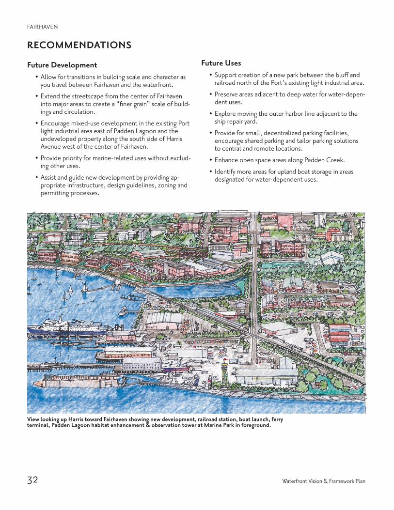
View looking up Harris toward Fairhaven showing new development, railroad station, boat launch, ferry terminal, Padden Lagoon habitat enhancement & observation tower at Marine Park in foreground.

33Waterfront Futures Group Final Recommendations
FAIRHAVEN
Environmental Cleanup & Enhancement
· Naturalize the area along the east side of Padden Lagoon.
· Enhance the estuary lagoon at Padden Creek, increase water flow through the railroad causeway and protect and enhance eelgrass beds in the adjacent near shore areas.
· Naturalize the shoreline area between the launch ramp and the cruise terminal.
· Protect and enhance eelgrass beds in the near shore adjacent to Marine Park and support plans to create a softened edge along the shoreline.
· Protect Post Point Lagoon from pollutants.
· Protect natural areas by enhancing or reintroducing na-tive vegetation.
· Utilize stormwater as a sustainable asset.
Culture & History
· Collaborate with Native American neighbors.
· Conduct an inventory to identify all the historic and na-tive sites and continue the practice of historic markers and protect existing known archeological site.
Connections & Access
· Provide a direct connection from Village Green and the rest of Fairhaven, diagonally northwest to the waterfront.
· Provide improved pedestrian pathways between Fairhaven and the railroad station and cruise terminal.
· Explore feasibility and methods for constructing a safe and convenient waterside trail near the railroad right-of-way through Fairhaven to connect to Edgemoor and Chuckanut Bay.
· Develop trail connections from Taylor Avenue Dock south through Fairhaven and redeveloped areas near the water to complete the South Bay link of the Coast Millennium Trail.
· Provide water jitney stops at Padden Lagoon and the public boat dock adjacent to the cruise terminal.
· Reconfigure and improve the existing public boat launch ramp, while providing for more short term and transient moorage.
· Reserve the 8th Street right-of-way for native vegeta-tion as a transition to adjacent development.
· Explore potential for Port to use portion of Alaska ferry parking lots south of Harris for boat trailer parking.
· Provide bus stops in close proximity to water jitney stops.

34 Waterfront Vision & Framework Plan
the vision for chuckanut and edgemoor is one that emphasizes conservation and public access. The rugged shoreline and tidelands will remain accessible only by water or on foot. Eventually a safe water-grade trail is envisioned that will connect to both Fairhaven and the Coast Mil-lennium Trail near Woodstock Farm. Woodstock Farm will become a new city park, and the railroad causeway across Chuckanut Bay will be perforated to improve water flow and allow for marine habitat enhancement. Kayak and other hand-carry landings will give boaters access to various points along the shoreline.
Looking south across Chuckanut Bay at railroad causeway penetrations, beach enhancements & Woodstock Farm.

35Waterfront Futures Group Final Recommendations
Chu
ckan
ut &
Edg
emoo
r

36 Waterfront Vision & Framework Plan
CHUCKANUT & EDGEMOOR
GUIDING PRINCIPLES
Reinforce the Inherent Qualities of Each Place on the Waterfront 1. Make the waterfront a regular part of the lives of more
people.
2. Respect history, cultures and the arts.· Embrace, include and expand knowledge of cultural
past
3. Make the waterfront inviting to people on foot.
4. Reinforce a unique “sense of place” at different water-front locations.· Protect the rugged shoreline and expansive tide-
lands, and preserve the natural features of the area· Preserve as a conservation area
5. Complement adjacent uses.
Restore the Health of Land & Water 1. Enhance or reintroduce natural systems.
2. Create and restore habitat wherever possible.
3. Remediate upland and in-water contamination.
4. Protect existing natural shorelines.· Preserve and protect the natural resources while
improving public access by foot or hand-carry boats
5. Seek opportunities to soften existing hardened shorelines.
6. Tailor environmental cleanup strategies and remedia-tion to planned use.
7. Manage stormwater to enhance estuarine habitats.· Treated or otherwise, assure the quality of storm-
water used to enhance estuarine habitats
8. Require sustainable practices in all development.· Use local and rapidly renewable materials for construction
9. Restore, enhance and expand beaches wherever possible.
10. Connect proposed open space and natural areas to regional open space network and wildlife corridors.
11. Explore mitigation banking and incentives (such as environmental credits) for environmental resource protection and enhancement prior to redevelopment.
Improve Waterfront Access 1. Develop strong connections between uplands and water.
2. Provide links to regional trail systems.
3. Provide multiple modes of access to each area of the waterfront.· Provide new and improve existing boating access points
4. Provide convenient connections between different modes of transportation (jitney/bus).
5. Create and connect large and small parks and open spaces with a “braided” system of pedestrian trails.
6. Enhance opportunities for visual access to waterfront areas.
7. Provide the opportunity to walk the waterfront while respecting natural habitat.
8. Help people find their way.· Provide pockets of open space along the shoreline
trail where opportunities exist
9. Provide way finding for the Coast Millennium Trail as a route that follows existing and proposed trails.
10. Explore the concept of public access “banking” and other financing incentives for improving public access.
11. Protect and enhance shoreline environmental resourc-es when designing for shoreline access and upland development.

37Waterfront Futures Group Final Recommendations
RECOMMENDATIONS
Connections
· Develop a trail connector above the rail tunnel to a viewpoint overlooking Bellingham Bay.
· Explore feasibility of constructing a safe and convenient pedestrian trail adjacent to the rail road right-of-way.
· Provide hand-carry boat landings at Poe’s Point and Woodstock Farm.
· Extend public access along the water from Fairhaven to Chuckanut Bay to connect to the Coast Millennium Trail near Woodstock Farm.
· Improve pedestrian access from parking areas along Chuckanut Drive.
· Continue to negotiate for upland trail to and from Chuckanut Bay.
· Develop short term and drop off parking at Woodstock Farm.
· Connect Arroyo Park/Interurban Trail to Chuckanut Bay/Inspiration Point.
· Develop a connection/strong link to Chuckanut Moun-tain and Larrabee State Park.
· Develop parking with trailhead amenities at North Chuckanut Mountain near California Street.
Natural Systems Protection & Open Space
· Perforate the railroad causeways across Chuckanut Bay to improve water circulation and reduce siltation.
· Maintain Clark’s Point as an open space resource.
· Complete master planning and implementation of the Woodstock Farm as a new city park.
· Address septic tank contamination in Chuckanut Bay.
Culture & History
· Collaborate with Native American neighbors.
· Conduct an inventory to identify all the historic and native sites.
· Locate heritage center at Woodstock Farm.
CHUCKANUT & EDGEMOOR

38 Waterfront Vision & Framework Plan

39Waterfront Futures Group Final Recommendations
App
endi
x M
ater
ialsThe following information is available through the Bellingham
Public Library System.
1. Waterfront Futures Project Background Information · Scope of Work and Inter-local Agreement · Waterfront Futures Project Frequently Asked Questions· Waterfront Futures Group members· Waterfront Futures Project Schedule Recap · prr Consultant Team members · Acknowledgements· wfg Retreat Materials· List of publications by the Futures Project · List of Business and Property Owners Interviewed · Existing Documents referenced by the wfg
2. White Papers and Public Comment· Agendas, Minutes, Meetings and list of Guest Forums · Public Comment· White Papers· Draft Plan public comment: June — September 2004
3. Reports and Publications· Waterfront Employment Survey by Brian Wilmot · Research on the Railroad by Stacy Fawell · wfg Work Group Initial Findings Reports· Waterfront Center Report · Design Assistance Team Report · Interagency Environmental Workshop Report· Map Appendix from Environmental Workshop · Waterfront Guide · wfg Annual Reports for 2003 and 2004
4. wfg Draft Recommendations and Comment· Draft Waterfront Vision · Draft Waterfront Framework Plan · Draft Waterfront Framework Plan Update – June 24, 2004 · Draft Waterfront Action Plan · Draft Plan public comment (See Section 2 above.)
5. Documents on cd· Waterfront Futures Project Background Information · Background Maps, pictures, and sketches· Public Process & Education and Outreach· Other Publications and Reports· wfg Draft Recommendations and Comment· wfg Final Recommendations
6. WFG Final Recommendations· Waterfront Vision· Waterfront Vision and Framework Plan – December 2004· Waterfront Action Plan – December 2004

40 Waterfront Vision & Framework Plan

Waterfront Futures Group MembersArt Anderson (Chair), Lydia Bennett (Vice-chair), John Blethen, Jay Bornstein, Craig Cole (2003), Bob Edie, Darrell Hillaire, Steve Koch, John Macpherson, Lynne Masland, Ted Mischaikov, Ray Tryznka
Planning Commission Liaisons Chris Morgan, Doug Starcher
Project Staff Patricia Decker, Waterfront Futures Project Director Allison Roberts, Administrative Assistant
Port of BellinghamExecutive – Jim Darling, Sue Conger, Mary Matyas, Carolyn Casey
Finance and Economic Development – John Carter, Andrea Bertollini, Dodd Snodgrass
Properties and Planning – Bill Hager
Marine Services – Stephan Jilk, Mike Endsley
Facilities – Fred Seeger, Susan French, Karen Callery
Environmental Services – Mike Stoner
Technical Assistance – Tim Cool
Events – Heidi Hertz, Alex Sands, Ally Vincent
City of BellinghamExecutive – Mayor Mark Asmundson, Janice Keller, Dick Little, Nicole Oliver, J Lynne Walker
Planning and Community Development – Jorge Vega, Greg Aucutt, Chris Behee, Kate Exall, Sheila Hardy, Chris Spens, Steve Sundin
Library – Julie Carterson, Gayle Helgoe, Marc Poulson
Finance – Therese Holm, Tammy Schoonover
Public Works – Dick McKinley, Clare Fogelsong, Clark Williams, Brent Baldwin
Museum – Tom Livesay, Jeff Jewell
Parks and Recreation – Paul Leuthold, Tim Wahl, Leslie Bryson
ITSD – Jim Baird, Patrick Lord, Cheryl Lord, Jackie Rimmer, Steve Niedermeyer, Daniel Meester
Consultants prr Consultant Team and staff – Marcia Wagoner, Jerry Ernst, Dennis Haskell, Susan H. Jones, Jeff Benesi, Michael Read, Dave Christensen, Robin Hoff, Jaime Smith
Retreat, Meeting Planning and Facilitation – Resolution Services (Rob Kelley, Mary Dumas) and cdm (Dave Christensen)
Website Design – Andrew McGlone, Kevin Marshall
Information brochures, notices, ad text – Wordworks (Chris Berner)
Environmental Workshop Report – Anchor Environmental Services (Peter Hummel), Coastal Geological Services (Jim Johannessen) and Fairbanks Environmental Services (Chris Fairbanks)
Design Assistance Team Facilitation and Report – Jerry Ernst, aia
Consultant Visit and Report – Waterfront Center (Ann Breen, Dick Rigby)
Other Service ProvidersVideotaping and Production for Guest Forums – Vidsmith (Lars Kongshaug)
Videotape Reproduction and Airing – cob-egtv (Jim Baird)
Printing Services and Supplies – Kinko’s, Copies Now, Applied Digital, Affordable Business Solutions
Public Meeting and Event Mailings – Automated Mailing Services
Project Assistance and Research – Jori Burnett, Stacey Fawell, Brian Wilmot
Catering – Sandwich Odyssey, Pacific Café, Food Pavilion, Fairhaven Market, Bagelry, Hotel Bellwether
Ack
now
ledg
emen
ts
Waterfront Futures Group Final Recommendations