Embed Size (px)
Citation preview
Watershed Analysis Manual K – Mass Wasting Prescription Reanalysis
Version 5.0 K-1 May 2011
Appendix K
Mass Wasting Prescription Reanalysis
Module
Table of Contents Introduction .......................................................................................... 2
Part 1 Review Process.......................................................................... 2
Part 2 Reanalysis of Mass Wasting Prescriptions ...................................... 3
Background .......................................................................................... 5 Reanalysis Process ................................................................................. 7 Reanalysis Mass Wasting Checklist ........................................................... 8 Form K-2 Mass Wasting Assessment Checklist ........................................... 9 Reanalysis Area ....................................................................................10 Reanalysis Process Initiation ..................................................................10 Critical Questions .................................................................................13 Assumptions ........................................................................................14 Landslide Inventory ..............................................................................15 Landslide Identification Information ........................................................16 Field Reconnaissance to Determine Land Use Associations and Contributing Factors ................................................................................................23 MWMU Development and Mapping ..........................................................23 Form K-3 Mass Wasting Map Unit Description Form ...................................25 Form K-4 Mass Wasting Reanalysis Summary Table ..................................27 Mass Wasting Hazard Potential Ratings for New MWMUs ............................27 Developing Overall Hazard Ratings .........................................................29 Mass Wasting Reanalysis Assessment Template ........................................30 Acknowledgments .................................................................................32
Watershed Analysis Manual K – Mass Wasting Prescription Reanalysis
Version 5.0 K-2 May 2011
Introduction This appendix describes the processes, as required in WAC 222-22-090(4), to keep watershed analysis mass wasting prescriptions current. Part 1 describes the Department of Natural Resources (DNR) process for review of approved watershed analysis (WSA) to determine if a reanalysis of mass wasting prescriptions is necessary. Part 2 describes the reanalysis process for mass wasting prescriptions. Part 1 Review Process The forest practices rules in WAC 222-22-090(4) and (6) direct DNR to perform reviews of approved watershed analyses to determine if reanalysis is required to maintain or update mass wasting prescriptions. Completing the following two steps will determine when a WSA is subject to mass wasting prescription reanalysis: 1. DNR will clarify and collect data for each of the following elements for each
Watershed Administrative Unit (WAU) within a WSA. Using these data the DNR will conduct a review to determine the need for reanalysis of mass wasting prescriptions. • Verify that mass wasting prescriptions (road construction and harvest)
exist for the watershed; • Determine if recent significant storm events have impacted any WAU(s); • Determine if the frequency of current landslides as compared to past
landslides have increased, then using current mass wasting inventories determine the potential for slides to threaten public safety;
• Determine the level of significant forest management activities planned in the WSA based on the number of approved and proposed Forest Practices Applications (FPAs) per WAU;
• Determine if previous reanalyses have been completed, and • Determine the degree of local stakeholder concerns within the WSA area.
2. DNR will, when determining a watershed reanalysis is required, notify all
landowners with 10 percent or more ownership of the nonfederal forest lands within any WAU within the WSA that may be subject to a reanalysis. Upon notification, these landowners will need to determine and notify DNR with which option they want to select: • Volunteer to sponsor the mass wasting prescriptions reanalysis process.
Sponsors provide funding and facilitation, and provide staff, including a qualified expert (QE), to conduct the assessment; or
• Volunteer to be a participant in the reanalysis process by providing staff with relevant geologic expertise, or
• Request DNR to withdraw the existing mass wasting prescriptions and agree to use the forest practices rule-identified landforms (WAC
Watershed Analysis Manual K – Mass Wasting Prescription Reanalysis
Version 5.0 K-3 May 2011
222-16-50 (1)(d)(i)(A-E)) and the associated avoidance/mitigation strategy.
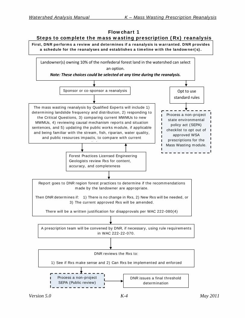
When steps 1 and 2 are completed and the landowner(s) chooses to conduct mass wasting prescription reanalysis, DNR will prioritize and schedule dates for completion of all WSA requiring mass wasting prescription reanalysis. Staggering reanalyses schedules for landowners of multiple watershed analyses will be considered in order to offset economic hardship. Part 2 Reanalysis of Mass Wasting Prescriptions The steps to complete a reanalysis of the mass wasting prescriptions within a WSA include many of the processes applied in Appendix A, Mass Wasting Resource Assessment of this board manual, found at http://www.dnr.wa.gov/Publications/fp_wsa_manual_appa.pdf.; and incorporates elements of the Landslide Hazard Zonation (LHZ) project protocols, found at http://www.dnr.wa.gov/Publications/fp_lhz_protocol_v2_1_final.pdf to help in the finalization of mass wasting map unit (MWMU) boundaries and revised or new prescriptions. An overview of the reanalysis process is shown in flowchart 1 below. The mass wasting reanalysis is conducted using aerial photographs, maps, and field observations. Based on the collection of information and the answers to critical questions, qualified experts interpret the mass wasting processes observed within the WSA. The reanalysis uses the standard mass wasting assessment method developed for Appendix A, Mass Wasting Resource Assessment.
Watershed Analysis Manual K – Mass Wasting Prescription Reanalysis
Version 5.0 K-4 May 2011
Flowchart 1 Steps to complete the mass wasting prescription (Rx) reanalysis
Landowner(s) owning 10% of the nonfederal forest land in the watershed can select an option.
Note: These choices could be selected at any time during the reanalysis.
Opt to use standard rules
Sponsor or co-sponsor a reanalysis
Report goes to DNR region forest practices to determine if the recommendations made by the landowner are appropriate.
Then DNR determines if: 1) There is no change in Rxs, 2) New Rxs will be needed, or 3) The current approved Rxs will be amended.
There will be a written justification for disapprovals per WAC 222-080(4)
DNR reviews the Rxs to:
1) See if Rxs make sense and 2) Can Rxs be implemented and enforced
Process a non-project SEPA (Public review)
Process a non-project state environmental
policy act (SEPA) checklist to opt out of
approved WSA prescriptions for the
Mass Wasting module.
DNR issues a final threshold determination
A prescription team will be convened by DNR, if necessary, using rule requirements in WAC 222-22-070.
The mass wasting reanalysis by Qualified Experts will include 1) determining landslide frequency and distribution, 2) responding to
the Critical Questions, 3) comparing current MWMUs to new MWMUs, 4) reviewing causal mechanism reports and situation
sentences, and 5) updating the public works module, if applicable and being familiar with the stream, fish, riparian, water quality,
and public resources impacts, to compare with current i ti
Forest Practices Licensed Engineering Geologists review Rxs for content, accuracy, and completeness
First, DNR performs a review and determines if a reanalysis is warranted. DNR provides a schedule for the reanalyses and establishes a timeline with the landowner(s).
Watershed Analysis Manual K – Mass Wasting Prescription Reanalysis
Version 5.0 K-5 May 2011
Background Mass wasting is a natural process that occurs in most forested basins in the Pacific Northwest. Certain forest management activities can accelerate mass wasting processes. Because the various slope processes generate widely variable amounts of sediment under different sets of conditions, qualified experts and specialists must identify specific associations between land use and landslides; then distinguish among the types and rates of processes that are active in a basin to accurately evaluate the mass wasting hazard potential. Evaluation of forest management activities in the context of terrain characteristics provides the best guidance in developing appropriate management prescriptions for reducing the potential for mass wasting. Four types of mass wasting commonly occur on forested slopes: shallow-rapid landslides, debris flows of various magnitude, large-persistent deep-seated landslides, and small-sporadic deep-seated landslides. Shallow-rapid landslides (also known as, debris slides, debris avalanches, or planar landslides) commonly occur on steep slopes where soil overlies a more cohesive material (for example, bedrock or glacial till). Soil thickness is typically small compared to slope length or the length of the landslide. Debris in the slide moves quickly down slope and commonly breaks apart to form a debris avalanche. Shallow-rapid landslides typically occur in convergent areas where topography concentrates subsurface drainage (Sidle and others, 1985), and may deliver sediment to streams and damage roads. Susceptibility of an area to shallow-rapid landslides is affected by steepness of slope, saturation of soil, and loss of root strength. Forest management activities can increase the occurrence of shallow-rapid landslides by altering these conditions; however, only a small portion (typically a few percent or less) of the landscape actually fails following timber harvest (Ice, 1985). A debris torrent contains a slurry that is 70-80 percent solids consisting of soil, rock, vegetation and water that can travel miles from its point of initiation. This highly mobile slurry typically flows in confined mountain channels with typical deposition reaches occurring with channel slope less than 35 degrees (70 percent) and tributary junction angles greater than 70 degrees. Debris torrents form when landslide materials liquefy concurrently with, or immediately after the initial slope failure. As the debris torrent moves through first- and second-order channels, the volume of material may be increased by several orders of magnitude over initial slide volume, enabling debris torrents to become more destructive the further they travel. Debris torrent initiation is generally confined to steep, colluvium-filled first and second-order channels; debris torrents can, however, deposit large volumes of unsorted sediment and organic debris in streams of any order, typically at tributary junctions (Benda, 1990) or on alluvial debris fans. Hence, debris torrents increase suspended
Watershed Analysis Manual K – Mass Wasting Prescription Reanalysis
Version 5.0 K-6 May 2011
sediment loading that can contribute sediment locally at the site of deposition and further downstream, depositing fine sediment in spawning gravels, causing secondary erosion of valley walls, and damaging structures, impairing water quality and fish habitat at considerable distances from their points of initiation (Eisbacher and Clague, 1984). Landslides and debris torrents that are deposited in narrow valley floors can create temporary dams that quickly impound water, creating small lakes. Failure of these dams can lead to extreme floods, referred to as landslide dam-break floods that can be up to two orders of magnitude greater in peak discharge than normal runoff floods. Such floods have caused extensive downstream erosion and sedimentation along entire stream segments throughout the mountainous regions of the state. Dam-break floods may also be triggered by the build-up and failure of logging slash in steep, first- and second-order streams (typically Type N waters) in managed forests. These dam break floods can cause slope failure of the valley walls (landslides) due to rapid loss of hydraulic head during the dam break process, The dam break floods, similar to debris torrents, can cause damage to structures, and/or destroy or affect fish habitat located at a considerable distance from their point of initiation. Deep-seated landslides occur in response to strong seismic shaking, geologic weakness, or channel incision. Climatic changes, ranging from major (such as glacial-interglacial transitions), to intermediate (runs of several wet years), to short-term (extreme storm precipitation) can also trigger or accelerate deep-seated landslides. The failure plane is below the colluvial layer and commonly cuts through two or more strata. These slides may persist in the landscape for a few years or centuries; in any case, debris is typically supplied from the margins of the features to a channel. The stream itself can be the cause of chronic movement, if it periodically excavates the toe of a large slide mass. Small-sporadic deep-seated landslides that move periodically can be triggered at irregular time intervals (by storms or earth movement), and can decay to the point where they are indiscernible in the landscape. Movement of deep-seated landslides is hydrologically controlled (at least in part), so land use can influence movement in certain situations. Excessive routing and infiltration as a result of road runoff could be routed to potentially unstable slopes. The time scale (relative or absolute) of landslide activity in a basin is important to understanding the sediment mass balance of a watershed. Landslide events may occur on a return interval of one or two years, decades, centuries, or even millennia. While the smaller, more frequent events may cause the fresh scars seen on the landscape, the larger, infrequent events are probably the real
Watershed Analysis Manual K – Mass Wasting Prescription Reanalysis
Version 5.0 K-7 May 2011
shapers of the landscape. Both types of landslides are influential in their impact on physical resources. In a natural, unmanaged forested basin, the dynamic replenishment of material to the channels by landslide activity is essential to the diversity and health of the ecosystem. Not all landslides deposit sediment directly in streams; sediments may be deposited on flood plains, glacial or alluvial terraces, or foot slopes, without reaching a stream. However, as basin area increases, the cumulative probability of either one small landslide entering a stream or one small failure triggering a debris torrent with catastrophic impact on habitat conditions increases.
Reanalysis Process This section describes the reanalysis process for mass wasting prescriptions. When landowner(s) commit to sponsor a reanalysis to retain their approved watershed analysis, DNR will: 1. Determine the geographic area(s) to be reanalyzed. 2. Determine the degree of expertise required for the team conducting the
reanalysis. 3. Provide necessary training for module(s) being reanalyzed. 4. Establish a timeline for the reanalysis. DNR will work with individual forest
landowners who are sponsoring or participating in each reanalysis to consider appropriate schedules.
5. Provide start-up products. Many of the needed products are available at DNR’s geo-spatial data website at: http://www.dnr.wa.gov/BusinessPermits/Topics/ForestPracticesApplications/Pages/fp_gis_spatial_data.aspx.Start-up products will include: a. 1:12,000 scale base map, with official WAU boundaries. Map will also
show elevation contours, streams, roads, section, township and range information, and known landslides; federal and tribal lands will be delineated. All maps will use the same coordinate scale. DNR will provide map standards. Note: Although federal and tribal lands will not be mapped as part of this project, any unstable slope data that is available for adjoining lands will be provided.
b. A map with all landslides from the current watershed analysis landslide inventories along with digital data for MWMUs.
c. DNR Slope Stability (SLPSTAB) data. d. Geologic maps: DNR’s Division of Geology & Earth Resources (DGER)
maps at 1:100,000 (or larger) scale. Use the latest 1:100,000 maps or local detailed geology maps. See DGER indices to geologic mapping (Manson 1984, 1994, 1995 or county bibliographies).
e. DNR Geographic Information System (GIS) also contains digital data on hydrology, forest roads and other information that may prove useful.
Watershed Analysis Manual K – Mass Wasting Prescription Reanalysis
Version 5.0 K-8 May 2011
f. Soil maps are available at http://www.wa.nrcs.usda.gov/programs/soil_survey.html
g. DNR may have digital data on precipitation zones, forest roads and canopy/core density of vegetation from DNR Information Technology Division.
If a qualified expert is familiar with ArcGIS, the process of “heads-up digitizing” will allow the creation of landslide polygons within GIS while using an orthophoto or other base. On-screen digitizing is an interactive process in which a map is created using previously digitized scanned information such as base photography or LiDAR data. This method of geo-coding is commonly called heads-up digitizing because the attention of the user is focused on the computer screen, and not on a digitizing tablet. This technique may be used to trace features from a scanned map or image to create new layers or themes. On-screen digitizing may also be employed in an editing session where there is enough information on the screen to accurately add new features without a reference image or map. The qualified expert should add to their base map all public roads, public water intakes, bridges, gravel pits and/or quarries that may have been constructed since the completion date of the current approved watershed analysis in regard to impacts to infrastructure. The addition of private forest roads would also be welcomed, especially if these roads are implicated in recent mass wasting events. Qualified Expert Qualifications The mass wasting reanalysis must be conducted by a qualified expert which is defined in WAC 222-10-030(5) as “a person licensed under chapter 18.220 RCW as either an engineering geologists or as a hydrogeologist (if the site warrants hydrologist expertise), with 3 years of field experience in the evaluation of relevant problems in the forested lands.” The qualified expert must also possess knowledge of hill slope processes (including erosion, transport, and deposition) and their relationship to forest management activities. Skill in aerial photo interpretation, landform analysis, and recognition of mass-movement features (including shallow-rapid landslides, debris torrents, and deep-seated landslides) in a variety of geomorphic settings is necessary.
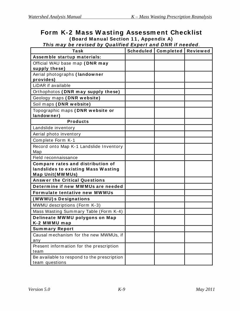
Reanalysis Mass Wasting Checklist It is recommended that qualified experts utilize the mass wasting assessment checklist, below, as a guide during their watershed mass wasting prescription reanalysis.
Watershed Analysis Manual K – Mass Wasting Prescription Reanalysis
Version 5.0 K-9 May 2011
Form K-2 Mass Wasting Assessment Checklist (Board Manual Section 11, Appendix A)
This may be revised by Qualified Expert and DNR if needed. Task Scheduled Completed Reviewed
Assemble startup materials: Official WAU base map (DNR may
supply these)
Aerial photographs (landowner provides)
LiDAR if available Orthophotos (DNR may supply these) Geology maps (DNR website) Soil maps (DNR website) Topographic maps (DNR website or
landowner)
Products Landslide inventory
Aerial photo inventory Complete Form K-1 Record onto Map K-1 Landslide Inventory
Map
Field reconnaissance Compare rates and distribution of landslides to existing Mass Wasting Map Unit(MWMUs)
Answer the Critical Questions Determine if new MWMUs are needed Formulate tentative new MWMUs (MWMU)s Designations
MWMU descriptions (Form K-3) Mass Wasting Summary Table (Form K-4)
Delineate MWMU polygons on Map K-2 MWMU map
Summary Report Causal mechanism for the new MWMUs, if
any
Present information for the prescription team
Be available to respond to the prescription team questions
Watershed Analysis Manual K – Mass Wasting Prescription Reanalysis
Version 5.0 K-10 May 2011
Reanalysis Area DNR determines the geographic areas within the WAU(s) in the WSA where the reanalysis will be conducted on forest lands. The forest practices rules in WAC 222-16-010 define forest land as “all land which is capable of supporting a merchantable stand of timber and is not being actively used for a use which is incompatible with timber growing. Forest land does not include agricultural land that is or was enrolled in the conservation reserve enhancement program by contract if such agricultural land was historically used for agricultural purposes and the landowner intends to continue to use the land for agricultural purposes in the future. For small forest landowner road maintenance and abandonment planning only, the term "forest land" excludes the following: 1. Residential home sites. A residential home site may be up to five acres in
size, and must have an existing structure in use as a residence;
2. Crop fields, orchards, vineyards, pastures, feedlots, fish pens, and the land on which appurtenances necessary to the production, preparation, or sale of crops, fruit, dairy products, fish, and livestock exist.”
Reanalysis Process Initiation 1. The first step in reanalysis is an inventory by the qualified experts of all
landslides that have occurred in the watershed since the completion date of the current approved WSA. The underlying assumption for this approach is that many of the activities that trigger mass wasting events have been conducted in the past in some or all of the areas sharing similar geomorphic characteristics (i.e., experiments). These prior “experiments” can be used to infer future erosion response.
2. Determine the potential for mass wasting by comparing the rate of past and
current landslides and associating the occurrence of landslides with terrain or geologic controls and features (landforms). These associations form the basis for the mapping of MWMUs in the watershed. The MWMUs are then drawn for each area with similar landslide characteristics and land use associations. These mechanisms are the specific geomorphic processes that appear to contribute to mass wasting (i.e., increased pore water pressure, over-steepened or over-loaded slopes, excess water drainage, etc.). Unique units are described if the mass wasting processes are similar (i.e., shallow debris flow), but the triggering mechanisms are different (i.e., roads versus loss of root strength on hill slopes). Many of the MWMUs identified during the initial watershed analysis process are now the rule-identified landforms found in WAC 222-22-16-050 (1)(d)(i), and described in Board Manual Section 16, Guidelines for Evaluating Potentially Unstable Slopes and Landforms.
Watershed Analysis Manual K – Mass Wasting Prescription Reanalysis
Version 5.0 K-11 May 2011
The key to the inventory and mapping of MWMUs is the use of time-series aerial photography. The photographs should be as chronologically extensive as possible. The following factors should be considered when choosing which photo years to analyze: • Use at least two sets of photos since the last set of photos used for
the current approved watershed analysis. • If available, use photo sets that will show landscape response to
storms. For example, major storms occurred in some areas in 2007 and 2009; use photo series immediately post-dating these events.
• If possible, use photos that best show exposed bare-ground conditions (for example, recently harvested areas) this will be especially useful for landform mapping.
• If available, use at least one set of high altitude photos (1:60,000), these will assist in identifying large deep-seated landslides.
• Choose a range of photo scales to analyze. Photographs at about 1:12,000 to 1:16,000 scale are best for detection of small features; scales of 1:24,000, 1:40,000, and 1:62,500 cover more area with fewer photographs, and are better for terrain evaluation, but provide reduced resolution. Color photographs are preferred because they allow detection of subtle differences in tone of soil and types of vegetation; however, they are more expensive and produced less often.
• National Agriculture Imagery Program (NAIP) color orthophotos (for both 2006 and 2009) are available from DNR for the entire state.
• Use LiDAR, if available, for identifying rule-identified landforms, convergent topography, more precise remote gradient determinations, and deep-seated landslides.
3. Assess and rate the potential for delivery from mass wasting events of
sediment and debris to streams within the watershed. For this assessment, qualified experts will apply the process in Appendix A, Mass Wasting Resource Assessment to their updated information to rate the potential for delivery of debris and sediment to streams by mass wasting for geographic zones of the basin. These ratings are applied to the "likelihood of adverse change and deliverability" axis of the cumulative effects rule matrix.
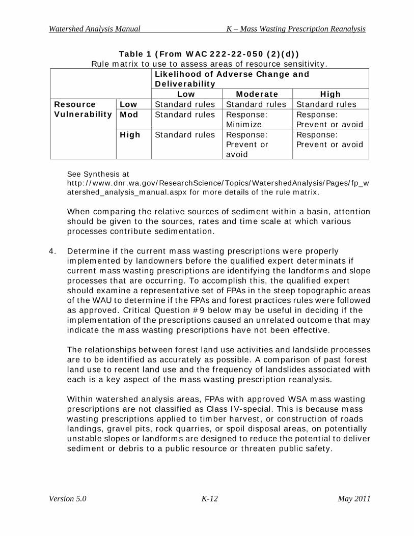
Table 1, from WAC 222-22-050(2)(d) outlines how to assess areas of resource sensitivity. Resource vulnerability may not need to be addressed in the reanalysis because resource vulnerabilities have already been identified in the current approved watershed analysis. However, the reanalysis should address the likelihood of adverse change and potential sediment deliverability as a result of the updated landslide inventory.
Watershed Analysis Manual K – Mass Wasting Prescription Reanalysis
Version 5.0 K-12 May 2011
Table 1 (From WAC 222-22-050 (2)(d)) Rule matrix to use to assess areas of resource sensitivity.
Likelihood of Adverse Change and Deliverability
Low Moderate High Resource Vulnerability
Low Standard rules Standard rules Standard rules Mod Standard rules Response:
Minimize Response: Prevent or avoid
High Standard rules Response: Prevent or avoid
Response: Prevent or avoid
See Synthesis at http://www.dnr.wa.gov/ResearchScience/Topics/WatershedAnalysis/Pages/fp_watershed_analysis_manual.aspx for more details of the rule matrix. When comparing the relative sources of sediment within a basin, attention should be given to the sources, rates and time scale at which various processes contribute sedimentation.
4. Determine if the current mass wasting prescriptions were properly implemented by landowners before the qualified expert determinats if current mass wasting prescriptions are identifying the landforms and slope processes that are occurring. To accomplish this, the qualified expert should examine a representative set of FPAs in the steep topographic areas of the WAU to determine if the FPAs and forest practices rules were followed as approved. Critical Question #9 below may be useful in deciding if the implementation of the prescriptions caused an unrelated outcome that may indicate the mass wasting prescriptions have not been effective. The relationships between forest land use activities and landslide processes are to be identified as accurately as possible. A comparison of past forest land use to recent land use and the frequency of landslides associated with each is a key aspect of the mass wasting prescription reanalysis. Within watershed analysis areas, FPAs with approved WSA mass wasting prescriptions are not classified as Class IV-special. This is because mass wasting prescriptions applied to timber harvest, or construction of roads landings, gravel pits, rock quarries, or spoil disposal areas, on potentially unstable slopes or landforms are designed to reduce the potential to deliver sediment or debris to a public resource or threaten public safety.
Watershed Analysis Manual K – Mass Wasting Prescription Reanalysis
Version 5.0 K-13 May 2011
Public resources are defined in WAC 222-16-010 as water, or capital improvements of the state. Potential for delivery exists when three conditions are met: • An impact is likely to occur; • The magnitude or size of the impact is sufficient to have a significant
adverse effect on the resource characteristic; and • The impact is likely to be delivered to a stream segment.
Critical Questions The following critical questions are specifically designed to be answered during the reanalysis process to help landowners determine if current mass wasting prescriptions are identifying the landforms and slope processes that are occurring in the WAU. The reanalysis critical questions are provided below. 1. Are there any newly identified areas of the landscape that are susceptible to
high landslide frequencies (i.e., areas not previously mapped or identified as MWMUs1)?
2. What is the distribution of new landslides throughout the landscape; are they found in existing MWMUs? on rule identified landforms?, or in new locations within the watershed?
3. Are forest management activities associated with landslide activity? 4. Can a determination be provided to analyze those slopes for which
prescriptions were followed but the slopes failed compared with those slopes that were covered under the same prescriptions but did not fail?
5. Have the prescriptions been properly implemented? The methodology for
answering this question is outlined in steps a through d below: a. Review a random subset of ≥10 year old FPAs using aerial photos
and if possible, field review to evaluate and verify the efficacy of potentially unstable landform buffers;
b. Conduct an aerial photo, LiDAR, and if necessary, field review to determine if potentially unstable slopes in MWMUs were identified;
c. Compare landslide locations to areas of buffered MWMUs;
1 Note that new landslides may occur in areas that match the criteria of existing mass wasting map units (MWMUs), but were not mapped due to small size or because forest cover previously obscured their presence. This question specifically asks the Qualified Expert to identify terrain or landform types not defined in the current approved watershed analysis as MWMUs, but are now recognized as potentially subject to high spatial landslide frequencies (high landslide densities).
Watershed Analysis Manual K – Mass Wasting Prescription Reanalysis
Version 5.0 K-14 May 2011
d. Determine landuse associations for landslides that occurred outside of MWMUs.
6. How does the distribution of new landslides compare to the distribution of
landslides at the time the WSA was approved; are the new landslides on existing MWMUs or not?
7. What, if any, new types of landslides have been discovered since the time
the current approved mass wasting analysis was completed? What landuses are associated with these landslides?
8. Have the newly inventoried landslides delivered sediment to public
resources? 9. How does the rate of new landslides compare to the initial rate of landslides
present when the watershed analysis was first approved, for example, how does the percentage of new landslides by forest landuse (e.g., ‘road-related’) compare to those inventoried in the current watershed analysis?
The conclusion to the answers of these questions will help determine if there are observed changes in landslide frequency or distribution and will be used to support any recommended changes to the mass wasting avoidance strategy, if necessary.
Assumptions A number of fundamental assumptions and requirements underlie the approach developed for reanalysis. The most fundamental requirement is that reanalysis be based on the best available scientific information and techniques. Thus, the reanalysis module methods are designed to change as new methods are developed. The underlying assumptions and reanalysis framework on the other hand are not. Rather, assumptions dictate a rigorous, yet flexible framework for reanalysis. Assumptions for completing the reanalysis include: • Delivery to typed waters will affect water quality or fish; • Landslides are occurring in the current approved WSA locations; • Fish are located at the same locations as in the current approved watershed
analysis; • The current approved watershed analysis fish and/or channel module
analyses have probably not changed to the point that would affect the mass wasting reanalysis; and
• The public works module will be revisited to include new infrastructure, if applicable.
Watershed Analysis Manual K – Mass Wasting Prescription Reanalysis
Version 5.0 K-15 May 2011
Technology and knowledge of mass wasting processes have improved since the completion of the original watershed analysis. These advances include: • Aerial photographs and LiDAR that can be used to interpret and document
the history of land use and mass movement in a basin. Although some features are obscured by vegetation, most landslides of significant size (1000 square yards) can be identified on aerial photos, as can the tracks of debris torrents and dam-break floods. The prescription reanalysis is not to identify a complete census of landslides in the watershed by intensive field reconnaissance, but a percentage (~10%) of the landslides must be field verified.
• Identification and spatial distribution of existing mass-movement features that can be used to predict the likelihood of future instability. Areas prone to these processes can be mapped based on physical characteristics, as interpreted from aerial photographs, LiDAR, topographic maps, and geologic maps.
• Although most landslides are partly caused by natural processes or events, in most cases, the initiation or acceleration of mass movement can be attributed either to natural conditions or to forest practices. Mass-movement features associated in time and space with logging or road activities are assumed to be caused by forest practices activities with the exception of very large storm events that are known to have occurred. Improperly constructed and maintained gravel pits and material waste sites can also trigger landslides.
It is feasible to extrapolate from one sub-basin to another having similar characteristics, based on information obtained from maps and aerial photos.
Landslide Inventory The purpose of the landslide inventory is to collect information that will aid in understanding the distribution, timing, and relative size of landslides in the basin that would be useful in creating MWMUs. The primary intent of mass wasting reanalysis is to evaluate and map the potential for delivery of mass wasting hazards for use in the synthesis and prescriptions modules. The qualified expert should review the existing landslide inventory and attribute tables before reviewing new photos in order to know where most slides would be expected. Existing landslides that have been reactivated may or may not be easy to identify when the reanalysis is conducted. Examine the aerial photographs in stereo (begin with earliest years to most recent) to identify landslides, debris torrents, and other erosion features to map the mass wasting features. The geo-spatial data sets that are available on the DNR website contain a landslide inventory http://www.dnr.wa.gov/BusinessPermits/Topics/ForestPracticesAppl
Watershed Analysis Manual K – Mass Wasting Prescription Reanalysis
Version 5.0 K-16 May 2011
ications/Pages/fp_gis_spatial_data.aspx . The DNR landslide inventory contains landslides from approved watershed analyses and from some LHZ projects. The attribute tables can be compared to determine if landslides on more recent photos are new or just reactivated. Using this data will resolve double counting of existing landslides that were mapped in the current approved mass wasting modules. Transfer the features into a GIS based data layer (Map K-1: Landslide Inventory) placed on the WAU base map. The process of on-screen digitizing is similar to conventional digitizing. Rather than using a digitizer and a cursor, the user is able to create the map layer on the screen with the mouse and typically with referenced information as a background, see http://www.ncgia.ucsb.edu/cctp/units/unit14/14.html for more information on this process. Assign an identification number to each landslide. The identification system will be established for each watershed area as there is a naming convention in place, see below. DNR will provide a distinct geographic identifier for each landslide in the inventory. This will enable users of this reanalysis to correlate landslides between maps, inventory lists, and text. The system explained will be used for the reanalysis. A standard map projection for GIS will be required for any GIS submitted products. On the form, arrange the observations by smaller sub-basins (as defined by the current approved watershed analysis) beginning at the upstream end of the watershed. Organization of the inventory in this manner, combined with recording the appearance and size of landslides by air photo dates (see below), allows the qualified expert to understand the spatial distribution and possible timing of mass wasting downstream through the basin.
Landslide Identification Information The attributes below marked with an asterisk are required on the form, others can be added if available. Landslide unique ID number This will be automatically assigned in the GIS entry process. DNR will give each landslide an identification number that will be unique in the statewide inventory system. Landslide identification number* The landslide identification number is assigned by the qualified expert while performing the inventory. This number should be unique for each landslide within a study area. If the watershed you are working on already has a
Watershed Analysis Manual K – Mass Wasting Prescription Reanalysis
Version 5.0 K-17 May 2011
numbering convention, continue that convention to be consistent within the WAU. Location Landslides will be entered in ArcGIS by the landowner qualified expert and the information will be sent to DNR for inclusion in the landslide inventory for the unique watershed. The elevation of the headscarp is usually close to the initiation location unless you have other information. Determinations of the initiation location may be useful for research or for critical questions. Landslide description and attributes* DS=debris slide was shallow rapid landslide(s) in current approved
watershed analysis manual DF=debris flow was shallow rapid landslide(s) in current approved
watershed analysis manual DA=debris avalanche was shallow rapid landslide(s) in current approved
watershed analysis manual? SA = snow avalanche was shallow rapid landslide(s) in current approved
watershed analysis manual? DT = debris torrent was the same in current approved watershed
analysis manual? RF/T = rock falls/ was not in current approved watershed analysis topples LPDS = large persistent was the same in current approved watershed deep-seated analysis SSDS = small sporadic was the same in current approved watershed deep-seated analysis EF = earthflow was not in current approved watershed analysis Definitions of shallow rapid landslides: 1. Debris Slide: A shallow landslide that forms from the disaggregation of
materials on a steep slope, involving the rapid movement of the soil and regolith over bedrock. This category includes those types of landslides also known as shallow-rapid, soil slips, and debris avalanches in Washington State’s watershed analysis method, per this Board Manual. The lack of significant water differentiates a debris slide from a debris flow.
Watershed Analysis Manual K – Mass Wasting Prescription Reanalysis
Version 5.0 K-18 May 2011
2. Debris Flow: A shallow landslide that flows within a channel formed either by the valley walls of a low-order tributary or by levees of its own making. It consists of soil and water with varying quantities of woody debris and is characterized by channelized flow, and often has a long run-out path. This category may include those events referred to as mud flows, debris torrents, hyper-concentrated slurries, and landslide dam-break floods.
3. Debris Avalanche: The rapid and unusually sudden sliding and flowage of
incoherent, unsorted, mixtures of soil and weathered bedrock that is not contained within a confined channel.
4. Rock Slides (Jackson, 1997): A slide involving a downward and usually
sudden and rapid movement of newly detached segments of bedrock sliding or slipping over an inclined surface of weakness, as a surface of bedding, jointing, or faulting, or other pre-existing structural feature.
5. Rock Topples and Falls: Shallow topples and falls consist of the individual
blocks of soil or rock that becomes detached from a steep slope and descend through the air by falling, bouncing, or rolling before coming to rest on gentler slopes. Soil topples and falls tend to disintegrate whereas rock topples and falls do not. Repeated topples and falls lead to soil blocks forming a convex colluvial foot-slope and rock blocks forming talus (includes all forms of topple and fall that cannot be identified as deep-seated). These may contribute to deep-seated landslide activity by loading at the headscarp.
6. Snow Avalanche: Failure within or at the base of the snow pack of alpine
areas that results in the rapid down-slope movement of snow, woody debris, and minor surface sediment to the base of the slope. The avalanche path results in an elongate area devoid of timber in the alpine and subalpine areas and fan-shaped deposits of rock and wood at the base of the slope.
Definitions of deep-seated landslides: Large deep-seated landslides are those in which most of the area of the slide plane or failure zone lies below the maximum rooting depth of forest trees, to depths from several to hundreds of meters (Washington Forest Practices Board, 2002). Deep-seated landslides involve glacial deposits, deep regolith, weathered rock, and/or bedrock, as well as surficial, pedogenic soil. As used here, deep-seated landslides include large (acres to hundreds of acres) slope landslides associated with geologic materials and structures. These landslides are commonly associated with geologic weakness and may be triggered by seismic shaking or channel incision. Climatic changes, ranging from major (e.g., glacial-interglacial transitions), to intermediate (runs of several
Watershed Analysis Manual K – Mass Wasting Prescription Reanalysis
Version 5.0 K-19 May 2011
wet years), to short-term events (extreme storm precipitation which may be coupled with antecedent moisture, hydrologic loading of the slope (e.g., road drainage), added weight at the head scarp, modification of the toe slope, etc.) may also trigger or accelerate deep-seated landslides. These landslides are defined as: 1. Large persistent deep-seated landslides: Commonly slump earthflows
involving large area of hillside; found in natural and managed landscapes, recognizable over long periods of time, and almost without exception predate land use.
2. Small sporadic deep-seated landslides: Commonly smaller slumps that can
be triggered at irregular time intervals (by storms or earth movements) and can decay to the point they are indiscernible.
3. Earthflows: A mass movement landform and process characterized by
down slope translation of solid and weathered rock over a discrete basal shear surface (landslide) within well-defined lateral boundaries. The basal shear surface is more or less parallel with the ground surface in the down slope portion of the flow, which terminates in a lobe like form. Overall, a little or no rotation of the slide mass occurs during displacement, although, in the vicinity of the crown scarp, minor initial rotation is usually observed in a series of slump blocks (Jackson, 1997).
The qualified expert will summarize all deep-seated landslides according to these characteristics: • Active/recent; • Dormant-distinct; • Dormant-indistinct; • Rotational; • Translational; • Combination. Certainty* D = Definite: the qualified expert is certain that this is a
Landslide. P = Probable: the qualified expert is not sure, but it is
probable that this is a landslide. Q = Questionable: the qualified expert is not certain that this is a landslide,
but is including it for completeness of the inventory, these landslides will not be in the GIS spatial data. The focus will be on field verification.
Watershed Analysis Manual K – Mass Wasting Prescription Reanalysis
Version 5.0 K-20 May 2011
A variety of factors govern the certainty with which a qualified expert can remotely identify a landslide including ground cover, age and size of landslides, the scale, aspect, or lighting conditions of an aerial photograph. These are intended to be qualitative statements as to the certainty the qualified expert has that the observed feature is a landslide. Landslides with a “questionable” designation will not be used in the landslide hazard calculations, but are included to note that the qualified expert did observe the feature. Additionally, on the first set of photos or LiDAR, the qualified expert should only map and tabulate those landslides for which they are sure is a landslide and that the landslide occurred shortly before the time the photo was taken, as there is no way to ‘age date’ the landslide. On the west side of the state it is common for landslide scars to re-vegetate within 15 years and there is little evidence of the failure decades afterwards (unless it is greater than ~ 5000 square yards). The assignment of relative certainty should guide field verification. ‘Questionable’ and ‘probable’ calls should be given the highest priority to resolve in the field. Older or re-vegetated features may be difficult to see on subsequent aerial photos, but may still be identifiable on the ground. ID Date* Year of initiation of the landslide: Note the date (or flight number) of the aerial photograph set in the column heading on Form K-1; arrange the flights from oldest (left column) to most recent (right column), preserving the last column for features that initiated after the latest photos (i.e., identified in the field). LS Size* area in square yards, using GIS mapping tools to estimate Record the approximate area of the slide in the column corresponding to the photo set being examined. If you are using heads-up digitizing it will be easy to measure the area of the landslide. 1 = very small (1 to 100 square yards) 2 = small (101 to 500 square yards) 3 = medium (501 to 2000 square yards) 4 = large (2001 to 5000 square yards) 5 = very large (greater than 5000 square yards) Slope Shape (lateral curvature)* 1 = convergent 2 = convergent to planar 3 = planar 4 = planar to divergent 5 = divergent Slope at initiation zone* - field data is always best • Using LiDAR
Watershed Analysis Manual K – Mass Wasting Prescription Reanalysis
Version 5.0 K-21 May 2011
DNR may be able to provide a GIS-based process to allow the user to define a polygon at the head of the landslide (initiation area) that will average the slope. • GIS-derived slope (percent) at initiation zone* Using digital elevation model (DEM) data, average the slope gradient within a polygon at the initiation area of the landslide. Land use (at initiation zone) Gravel pit or quarry CC = clear cut MT = mature timber RR = road OR = orphan road* AR = abandoned road* L = landing AR = agricultural road A = agriculture USB = unstable slope buffer *Use RMAP information if available We differentiated harvest unit from mature timber. If the initiation location is on or obviously from a road or unstable buffer, use those land use categories. Age class of trees (2009 at initiation zone) 0 to 5, 5 to 20, 20 to 50, and 50+ years The ambiguity associated with the duplication of ages between classes is deliberate because not all specific age classes are known. If definitive ages are known, use those. Delivery to a public resource* Public resources per WAC 222-16-010 are defined as water, fish, and wildlife and in addition mean capital improvements of the state or its political subdivisions. If Yes, identify the resource: Stream (F or N) Infrastructure that may include bridges, roads, houses, and public water intakes, etc. If No, identify the location as forest floor, field, or private forest road, etc. Indeterminate (Ind) means that the qualified expert could not see if there was delivery to a public resource.
Watershed Analysis Manual K – Mass Wasting Prescription Reanalysis
Version 5.0 K-22 May 2011
Identifying existing MMWU in GIS (screening tool)* Use the number of the MWMU from the current approved watershed analysis hazard zone from the DNR GIS spatial database for this entry. Is the landslide associated with a "Rule-Identified Landform" as listed in WAC 22-16-050?* Input information is: Yes/No/Non FP Rules Land/tribal/other. Type of Landform* Remote landform assessment cannot determine if a landform is a rule–identified feature with certainty. Note the information if a landform is a field-verified, rule–identified landform IG = inner gorge BH = bedrock hollow CH = convergent headwall Toes of DSLS, and OM = outside edges of meander bends edges along high terraces or valley walls Ind = indeterminate Stream erosion = natural or storm-related if possible to discern Cautionary comment DEMs and LiDAR gradients may not be conclusive for determining rule-identified gradients. It is not feasible to field verify every rule-identified landform as stated in WAC 222-16-050(1)(d)(i) using remote sensing methods. For example, if there is a convergent headwall and the DEM-derived gradient is 70 percent it may not be a rule-identified landform. However, studies such as Dragovich, 1993 determined that DEM-derived gradients may be off by 10 to 15 percent. If the DEM-derived gradient is close to 80 percent or the LiDAR-derived gradient is 74 percent and greater it is acceptable to make a professional call that you are confident there is a rule-identified landform. Comments Add any information that may be valuable for the particular landslide. Other optional attributes for discussion: • Geology • Soils (perhaps engineering properties) • Timber yarding impacts • Specific road practices
o Sidecast o Plugged culvert
Watershed Analysis Manual K – Mass Wasting Prescription Reanalysis
Version 5.0 K-23 May 2011
o Water concentration
Field Reconnaissance to Determine Land Use Associations and Contributing Factors The qualified experts should perform a field inspection of the basin to resolve major uncertainties regarding: a. The physical conditions associated with landsliding, and the particular
characteristics that should be used in establishing the MWMUs; b. Inferred land use associated with landslides (e.g., road sidecast,
undersized culverts); c. Delivery of sediment to streams, public works, etc.; and d. Extrapolation of map units to lesser-known areas. An intermediate decision point to-choose an option Upon completion of the landslide inventory three situations may occur: 1. It is readily apparent that the majority of the landslides occur in locations
that are similar to the current approved mass wasting analysis and the MWMU descriptions, processes, and land use are similar. You may not have to create new MWMUs. Your choices are: a. If there are non-specific prescriptions for these MWMUs, review the
critical questions and determine if the reanalysis will change the MWMU prescriptions. If not, terminate the review at this point and choose the option to use standard rules; there will be no operational change for the process of addressing potentially unstable slopes in the watershed. Notify DNR and begin a non-project SEPA.
b. If the prescriptions are specific and a change is needed, then proceed with the rest of the reanalysis.
2. If the landslides do not correlate to the same landforms as in the current
analysis and you can identify new MWMUs (potentially unstable landforms) then you may have the choice of creating new mass wasting prescriptions and continuing with the reanalysis.
3. Decide if selecting the standard rules would be the more protective option.
MWMU Development and Mapping Before creating new MWMUs the qualified expert should determine if the existing MWMUs can incorporate the landscape in areas of high landslide densities. Landslides that occur in high hazard MWMUs are typically where landslides are predicted to occur. Refer to the existing MWMU descriptions in your watersheds to see if the characteristics of the landslides you are observing
Watershed Analysis Manual K – Mass Wasting Prescription Reanalysis
Version 5.0 K-24 May 2011
seem to be like the descriptions of the landslides that were used to create any of the existing MWMUs. If you have LiDAR you may be finding landforms (that are or are not representative of existing MWMUs) that were difficult to detect with aerial photography alone. Recent aerial photography can also expose landforms in clear-cuts or burned areas. Look at the following characteristics to help in the decision to create new MWMUs. • Landslide processes and landslides densities • Slope gradients and landforms • Bedrock types and structures • Surficial materials The reanalysis is partitioned into map units, based on physical characteristics contributing to landslide activity, and the potential for landslide sediment to enter streams or affect other public resources that have been clearly delineated. • Inspect the landslide inventory data and map and note the geologic and
geomorphic factors associated with each mass wasting feature type. What new mass wasting features are present in the basin and how are they distributed?
• If there are landslides that do not seem to be associated with any of the characteristics of the other MWMUs, try to define similarities among your newly inventoried landslides.
• The new MWMUs should have areas of terrain having similar physical characteristics and mass-movement behavior. (Do not differentiate map units based on the presence or absence of management activities at this point. Landscape sensitivity to management practices is evaluated in the hazard ratings).
In addition, each MWMU should be unique with respect to at least one of the following: landform, process, density, and delivery. The number and nature of map units designated in a watershed will depend on the geomorphic complexity of the basin. Although the qualified expert is free to design MWMUs appropriate to the area being examined, there must be consistency in the character of the individual map units that comprise each new MWMU types (particularly among adjacent basins). For guidance, see Rib and Liang, 1978; Fiksdal and Brunengo, 1981; Varnes 1984; Sidle, et al., 1985; Howes and Kenk, 1988; Chatwin, et al., 1991. Create a new GIS layer that outlines the map units and add the new MWMUs to the MWMU map (Map K-2 Mass Wasting Potential). Label the MWMUs by number; for units with multiple polygons, include a polygon number for each (e.g., 3-1, 3-2, etc.).
Watershed Analysis Manual K – Mass Wasting Prescription Reanalysis
Version 5.0 K-25 May 2011
Summarize information on each MWMU into a concise summary form (see Form K-3, Mass Wasting Map Unit Description Form). Write a brief description of the physical characteristics, mass movement history and behavior, sediment delivery characteristics, and associations with forest practices for each new MWMU. Descriptions should be as quantitative and objective as possible.
Form K-3 Mass Wasting Map Unit Description Form (From Board Manual Section 11, Appendix A and Landslide Hazard
Zonation Protocol, 2006) Form K-3 Mass Wasting Reanalysis Map Unit Description Form
MWMU Number #1
Description Steep (>65%) relatively planar slopes adjacent to stream channels
Materials Shallow permeable soils, containing both colluvium and glacial sediments mantling competent but fractured andesitic bedrock
Landform Example: Inner gorge : a narrow inset V-shaped valley characterized by steepening of slope gradient above stream channels, with more or less distinct break in gradient between the relatively planer inner gorge slope and the lower gradient hillslope above. Relief of the inner gorges (measured from the slope break) varied between about 30 to 150 feet. The inner gorge slope typically runs directly to the active stream channel.
Slope/ Slope shape
>65% (33 degrees) measured on site, convex, concave, planar, or mixed
Lithology Geologic Units and/or soils Elevation 600 ft to 3800 ft Total area ~ 5 % of the total WAU acres Mass Wasting Process
10 road-related shallow rapid landslides: 5 side cast landslides, 3 fill landslides all at stream crossings, 2 down slope shallow rapid landslides associated with concentrated surface water discharge from roads. 6 non-road-related landslides: 5 in clearcut harvest units (each of which was less than 20 years old), 1 in mature forest with not previous harvest
Landslide Density
Optional: 1 landslide per 269 acres observed over the 30 year record (0.08 landslides per square mile per year)
Forest Practices Sensitivity
High sensitivity to road construction activities, Moderate sensitivity to harvest
Mass Wasting Moderate , there is a potential for landslides under forest
Watershed Analysis Manual K – Mass Wasting Prescription Reanalysis
Version 5.0 K-26 May 2011
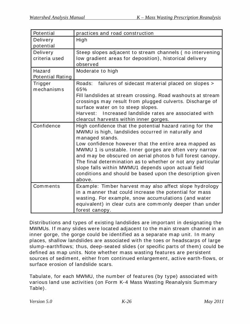
Potential practices and road construction Delivery potential
High
Delivery criteria used
Steep slopes adjacent to stream channels ( no intervening low gradient areas for deposition), historical delivery observed
Hazard Potential Rating
Moderate to high
Trigger mechanisms
Roads: failures of sidecast material placed on slopes > 65% Fill landslides at stream crossing. Road washouts at stream crossings may result from plugged culverts. Discharge of surface water on to steep slopes. Harvest: Increased landslide rates are associated with clearcut harvests within inner gorges.
Confidence High confidence that the potential hazard rating for the MWMU is high, landslides occurred in naturally and managed stands. Low confidence however that the entire area mapped as MWMU 1 is unstable. Inner gorges are often very narrow and may be obscured on aerial photos b full forest canopy. The final determination as to whether or not any particular slope falls within MWMU1 depends upon actual field conditions and should be based upon the description given above.
Comments Example: Timber harvest may also affect slope hydrology in a manner that could increase the potential for mass wasting. For example, snow accumulations (and water equivalent) in clear cuts are commonly deeper than under forest canopy.
Distributions and types of existing landslides are important in designating the MWMUs. If many slides were located adjacent to the main stream channel in an inner gorge, the gorge could be identified as a separate map unit. In many places, shallow landslides are associated with the toes or headscarps of large slump-earthflows; thus, deep-seated slides (or specific parts of them) could be defined as map units. Note whether mass wasting features are persistent sources of sediment, either from continued enlargement, active earth-flows, or surface erosion of landslide scars. Tabulate, for each MWMU, the number of features (by type) associated with various land use activities (on Form K-4 Mass Wasting Reanalysis Summary Table).
Watershed Analysis Manual K – Mass Wasting Prescription Reanalysis
Version 5.0 K-27 May 2011
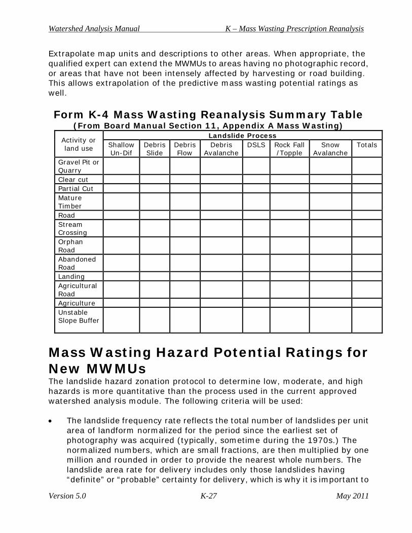
Extrapolate map units and descriptions to other areas. When appropriate, the qualified expert can extend the MWMUs to areas having no photographic record, or areas that have not been intensely affected by harvesting or road building. This allows extrapolation of the predictive mass wasting potential ratings as well. Form K-4 Mass Wasting Reanalysis Summary Table
(From Board Manual Section 11, Appendix A Mass Wasting)
Activity or land use
Landslide Process Shallow Un-Dif
Debris Slide
Debris Flow
Debris Avalanche
DSLS Rock Fall /Topple
Snow Avalanche
Totals
Gravel Pit or Quarry
Clear cut Partial Cut Mature Timber
Road Stream Crossing
Orphan Road
Abandoned Road
Landing Agricultural Road
Agriculture Unstable Slope Buffer
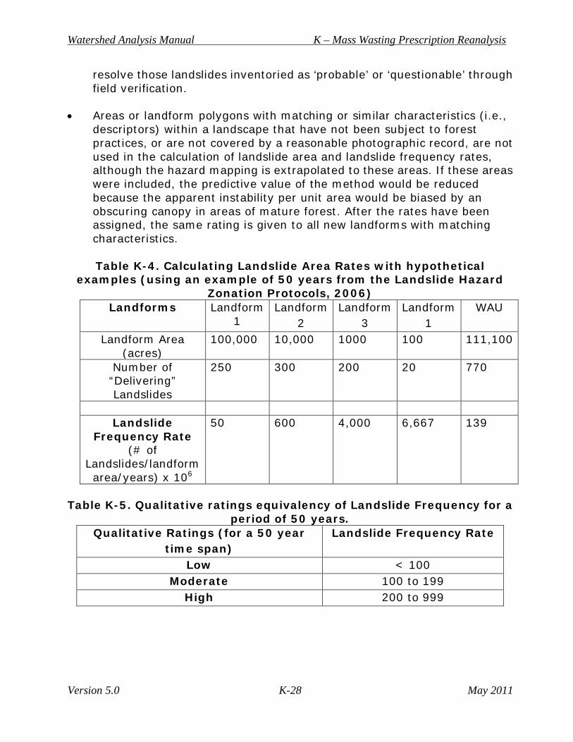
Mass Wasting Hazard Potential Ratings for New MWMUs The landslide hazard zonation protocol to determine low, moderate, and high hazards is more quantitative than the process used in the current approved watershed analysis module. The following criteria will be used: • The landslide frequency rate reflects the total number of landslides per unit
area of landform normalized for the period since the earliest set of photography was acquired (typically, sometime during the 1970s.) The normalized numbers, which are small fractions, are then multiplied by one million and rounded in order to provide the nearest whole numbers. The landslide area rate for delivery includes only those landslides having “definite” or “probable” certainty for delivery, which is why it is important to
Watershed Analysis Manual K – Mass Wasting Prescription Reanalysis
Version 5.0 K-28 May 2011
resolve those landslides inventoried as ‘probable’ or ‘questionable’ through field verification.
• Areas or landform polygons with matching or similar characteristics (i.e.,
descriptors) within a landscape that have not been subject to forest practices, or are not covered by a reasonable photographic record, are not used in the calculation of landslide area and landslide frequency rates, although the hazard mapping is extrapolated to these areas. If these areas were included, the predictive value of the method would be reduced because the apparent instability per unit area would be biased by an obscuring canopy in areas of mature forest. After the rates have been assigned, the same rating is given to all new landforms with matching characteristics.
Table K-4. Calculating Landslide Area Rates with hypothetical
examples (using an example of 50 years from the Landslide Hazard Zonation Protocols, 2006)
Landforms Landform 1
Landform 2
Landform 3
Landform 1
WAU
Landform Area (acres)
100,000 10,000 1000 100 111,100
Number of “Delivering” Landslides
250 300 200 20 770
Landslide
Frequency Rate (# of
Landslides/landform area/years) x 106
50 600 4,000 6,667 139
Table K-5. Qualitative ratings equivalency of Landslide Frequency for a
period of 50 years. Qualitative Ratings (for a 50 year
time span) Landslide Frequency Rate
Low < 100 Moderate 100 to 199
High 200 to 999
Watershed Analysis Manual K – Mass Wasting Prescription Reanalysis
Version 5.0 K-29 May 2011
Developing Overall Hazard Ratings Assign a low, moderate, or high rating to the landform based on Table K-5. Put these values into Table K-5 to develop the overall hazard rating in consideration of the additional criteria listed below. These results will provide the basis for comparison among watersheds throughout the state (Excerpted from the LHZ project protocol 11/30/2006 Version 2.1 30 of 50). Using landslide frequency rates for assigning overall hazard ratings Except for rule-identified landforms, most overall hazard ratings will be assigned on the basis of the semi-quantitative hazard ratings. The current guidelines for the landslide frequency are based on twenty-seven landforms analyzed as Priority II Watersheds under the LHZ project (Lingley, 2004a, b; Wegmann, 2004), on the data used to define rule-identified landforms. Landslide frequency rate values are converted to qualitative ratings using Table K-4 and these are entered into Table K-5 to generate overall hazard ratings. While this method provides a better means of comparing watersheds in different parts of Washington, users should keep in mind that overall hazard ratings derived from this method are estimations only. This should be restated in each summary report. (Note: These semi-quantitative guidelines may be modified in the future.) For an inference to be valid, the known area and the unmapped area must be comparable in materials, landforms, and (to the extent known) landslide types. Important characteristics that should be similar include all of those used to define the known MWMU, especially: • Slope form and gradient; • Bedrock and soil/surficial material types; • Elevation, climatic zone; and • Vegetation type. The greater the similarity of these characteristics between the known and unknown areas, the greater the confidence will be in the extrapolation of hazard ratings. If there are large differences between the areas, extrapolation should not be attempted and indeterminate ratings should be assigned to the unmapped or unknown area. Ratings of the potential hazard of landslide debris or sediment to be delivered to streams and other public resources are assigned to the MWMUs. The ratings are determined on the basis of occurrence of landslides in the past (recognized in the current approved landslide inventory and the landslide inventory created for the reanalysis). There are often relationships among forest practices and landslide occurrence and the likelihood that debris or sediment will be delivered
Watershed Analysis Manual K – Mass Wasting Prescription Reanalysis
Version 5.0 K-30 May 2011
to sensitive locations or waters (mass wasting map unit descriptions, Form K-2). Each element is part of the rating. Consider the following factors when making hazard ratings: • What is the natural potential for mass wasting processes? • Are the mass wasting processes associated with forest practices? • What is the potential for sediment to be delivered to streams or other
waters?
The ratings address the most likely sediment sources in the watersheds, some basins may not contain a MWMU with a high hazard rating while others may not include any low ratings. Hazard-potential ratings for mass wasting are derived from both mass wasting potential and delivery potential. Both components of the rating should be included in the MWMU description form with appropriate justification, evidence, and confidence addressed. Indicate the ratings for hazard potential assigned to the MWMUs. It may be desirable to designate MWMUs on the current approved 1:24,000 map in color for use by the prescription teams. All polygons should be clearly labeled with the MWMU and hazard shading. Comments need to include the following: • Complexity of the basin; • Extent of field-checking and accessibility to basin; • Scale and range of aerial photograph coverage and length of record; • Quality and quantity of other information; • Additions to or deviations from standard methods; and • Skill level of the qualified expert.
Mass Wasting Reanalysis Assessment Template
I. Title page with name of current approved watershed analysis, name of module, level of analysis, signature of qualified qualified expert(s), and date. All forms listed below can be found in Appendix A, Mass Wasting Resource Assessment.
II. Table of contents
III. Maps
• Mass wasting landslide inventory (Map K-1) • New MWMUs and hazard potential ratings (Map K-2)
Watershed Analysis Manual K – Mass Wasting Prescription Reanalysis
Version 5.0 K-31 May 2011
IV. Summary Data • Mass wasting summary table (Form K-4) • Mass wasting inventory data (Form K-5 to be distributed by DNR) • New MWMU description form (Form K-3)
V. New mass wasting map units • Description: • Materials: • Landform: • Slope: Elevation: • Total Area: • MW Processes: • Non-road-related Landslide Density: (optional) • Forest Practice Sensitivity: • MW Potential: • Delivery Potential: • Delivery Criteria Used: • Hazard Potential Rating: • Trigger Mechanism(s): • Confidence: • Comments:
VI. Summary Text
• Answer all the critical questions for the reanalysis • Check to make sure that the report addresses all critical questions • Summaries of reanalysis and results • Descriptions of MWMUs • Description and explanation of mass wasting potential ratings • Statement on trigger mechanisms • Statement of the author’s confidence level in the analysis and
results
Watershed Analysis Manual K – Mass Wasting Prescription Reanalysis
Version 5.0 K-32 May 2011
Acknowledgments References from the current approved watershed analysis mass wasting module Benda, L., and T. W. Cundy. 1990. Predicting deposition of debris flows in mountain channels. Canadian Geotechnical Journal. v. 27, pp. 409-417. Chatwin, S. C., D. E. Howes, J. W. Schwab, and D. N. Swanson, 1991, A guide for management of landslide-prone terrain in the Pacific Northwest. British Columbia Ministry of Forests, Land Management Handbook 18, 212 p. Coho, C., and S. J. Burges, 1994, Dam-Break Floods in Low Order Mountain Channels of the Pacific Northwest, Water Resources Series Technical Report No. 138, Dept. of Civil Engineering, Univ. of Washington, Seattle, TFW-SH9-91-001, 23 p. Costa, J. E., and R. L. Schuster, 1988, The formation and failure of natural dams. Geol. Society of America Bulletin, v. 100.7, pp. 1054-68. Dietrich, W. E. and Dunne, T., 1978, Sediment budget for a small catchment in mountainous terrain: Z. Geomorphology Supplement 29, pp. 191-206. Eisbacher, G. H., and J. J. Clague. 1984. Destructive mass movements in high mountains: hazards and management. Geologic Survey of Canada, pp. 8-16, 230 p. Fiksdal, A. J., and M. J. Brunengo, 1981, Forest slope stability project, phase II. Wash. Dept. of Ecology, Technical Report 81-14, 62 p. Howes, D. E., 1987, A terrain evaluation method for predicting terrain susceptible to post-logging landslide activity - a case study from the Coast Mountains of British Columbia. British Columbia Ministry of Environment and Parks (MOEP), Technical Report 28, 38 p. Howes, D.E., and E. Kenk, 1988, Terrain classification system for British Columbia (rev’d ed). British Columbia Ministry of Environment (MOE), Manual 10, 90 p. Ice, G. G., 1985, Catalog of landslide inventories for the Northwest. National Council of the Paper Industry for Air and Stream Improvement (NCASI), Technical Bulletin 456, 78 p plus appendices.
Watershed Analysis Manual K – Mass Wasting Prescription Reanalysis
Version 5.0 K-33 May 2011
Johnson, A. C., 1990, The effects of landslide dam-break floods on the morphology of channels. [Unpubl master’s thesis], College of Forest Resources, Univ. of Washington; TFW-SH17-91-001, 90 p. Kenard, P., 1994. Road Assessment Procedure (RAP), consultant report to the Weyerhaeuser Company, Tacoma, WA. Manson, C. J., 1984, Index to geologic and geophysical mapping of Washington, 1899-1983. Wash. Division of Geology & Earth Resources (WDGER), Information Circular 77, 56 p. Manson, C. J., 1994, Preliminary bibliography and index of the geology and mineral resources of Washington, 1993. WDGER, Open File Report 94-15, 102 p. Manson, C. J., 1995, Geologic and geophysical mapping of Washington, 1984-1994; and Theses on the geology of Washington 1986-1994; WDGER, Open File Report 95-2, 41 p. Montgomery, D. R., and W. E. Dietrich, 1994, A physically-based model for the topographic control on shallow landsliding: Water Resources Research, v. 30.4, pp. 1153-1171. Pentec Environmental, Inc., 1991, Methods for testing effectiveness of Washington forest practices rules and regulations with regard to sediment production and transport to streams: report submitted to Wash. Dept. of Natural Resources, TFW-WQ8-91-008, 100 p. Pierson, T. C., and J. E. Costa, 1987, A rheologic classification of subaerial sediment-water flows: in Costa, J. E., Wieczorek, G. F., eds., Debris flows/ avalanches - process, recognition, and mitigation: Geol. Society of America, Reviews in Engineering Geology, v.7, pp. 1-12. Rib, H. T., and Ta Liang, 1978, Chapter 3, Recognition and identification; in R. L. Schuster and R. J. Krizek, editors, Landslides: analysis and control. National Academy of Sciences, Transportation Research Board Special Report 176, pp. 34-80. Shaw, S. C., and D. Johnson, 1995, Slope morphology model derived from digital elevation (DEM) data: Wash. Dept. of Natural Resources - Forest Practices Division OFR 94-1. Sidle, R. C., A. J. Pearce, and C. L. O’Loughlin, 1985, Hillslope stability and landuse. American Geophysical Union, Water Resources Monograph 11, 140 p.
Watershed Analysis Manual K – Mass Wasting Prescription Reanalysis
Version 5.0 K-34 May 2011
Swanson, F.J., and R. J. Janda, T. Dunne, D. N. Swanston, 1982, Sediment budgets and routing in forested drainage basins: USDA Forest Service General Technical Report PNW-141, 165 p. U.S Geological Survey, 1992. Washington Index to topographic and other map coverage [catalogue]. U.S.G.S national Mapping Program, 48 p. Varnes, D. J., 1984, Landslide hazard zonation: a review of principles and practice. UNESCO Natural Hazards series n. 3, 63 p. Wieczorek, G. F., 1984, Preparing a detailed landslide-inventory map for hazard evaluation and reduction. Assoc. of Engineering Geologists Bulletin, V. XXI.3., pp. 337-342. Wu, T. H., C. J. Merry, M. Abdel-Latif, C. P. Benasly, 1993, Landslide hazard mapping - 1. Estimating piezometric levels: report submitted to Wash. Dept. of Natural Resources, TFW-SH15-93-001, and 100 p. Citations for this reanalysis document Dragovich, J.D.; Brunengo, M. J.; Gerstel, W. J., 1993, Landslide inventory and analysis of the Tilton Creek-Mineral River area, Lewis County, Washington; Part 1-Terrain and geologic factors: Washington Geology, v. 21, no. 3, p. 9-18. Landslide Hazard Zonation Project Protocol, Version 2.1. 2006. Prepared by the Upslope Processes Science Advisory Group (UPSAG), a subcommittee of the Cooperative Monitoring, Evaluation, and Research (CMER) committee. Forms and worksheets to be distributed by DNR