Embed Size (px)
Citation preview

1
Watershed Models for Storm Water Management: A Review for Better Selection and ApplicationJamie H. Weist, P.E. and Deva K. Borah, P.E., PhD
Woolpert, Inc.415 Port Centre Parkway, Suite 101Portsmouth, Virginia 23704-4924
Manager’s Perspective
• When selecting a model:– Keep the end use in mind– Understand the
limitations of the model

2
Manager’s Perspective
• Regulatory Pressure– Water Quality and
TMDL’s
• Development Pressure– Urban growth, limited
available land
• Public Pressure– Flooding and streambank
erosion
Manager’s Perspective
• Prediction Analysis– Ability to manipulate for
various land use scenarios
– Development of Comprehensive Plans and Capital Improvement Programs

3
Model Selection Criteria
• Cost Considerations• Integration Issues• User Interface • Range of Model
Applicability
Cost Considerations
• Needs vs. Return on investment
• Budget realities• Public perception • Public vs. Proprietary• Data input requirements• Hardware requirements
4
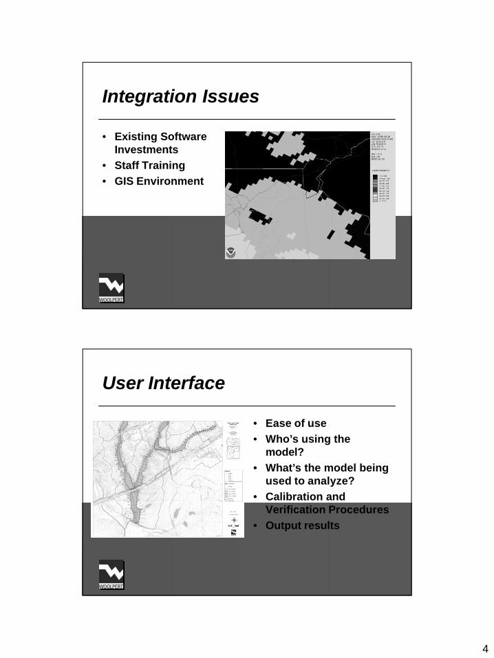
Integration Issues
• Existing Software Investments
• Staff Training• GIS Environment
User Interface
• Ease of use• Who’s using the
model?• What’s the model being
used to analyze?• Calibration and
Verification Procedures• Output results

5
Range of Model Applicability
• Understanding the model’s limitations
• Understanding the model’s intended use
• Flexibility/Diversity– Size of watershed– Type of watershed
• Level of accuracy and capabilities
Summary
• Water Resource Managers are typically not modelers
• Meeting the needs of the end user is key • Model selection based on defined criteria is
important due to the diversity of choices

6
Watershed Modeling
• Hydrology: Surface and subsurface flow.
• Sediment: Soil erosion and sediment transport.
• Pollutants: Nutrient, pesticide, and other chemical transport.
Example: Court Creek Watershed in Knox County, Illinois (Pilot Watershed & CREP)

7
Monitoring for Calibration and Validation of Model (Roseboom et al., 1982)
Monitoring Station: Big Ditch in Illinois

8
Spatially Distributed modeling: Watershed Subdivisions
Subdivision Conceptualization and Approximations

9
Modeling Physical Processes
Watershed Models for Storm water Management: Reviews• AGNPS
USDA-ARS• CASC2D/GSSHA
USACE• DR3M/DR3M-QUAL
USGS• DWSM
Woolpert/Borah• HEC-HMS
USACE-HEC
• HSPFUSEPA
• HydroworksWallingford
Software• IDEAL
Barfield et al.• KINEROS
USDA-ARS• LSPC
USEPA

10
Watershed Models for Storm water Management: Reviews• MIKE SHE
Danish Hydraulic Inst.• MOUSETRAP
Danish Hydraulic Inst.• MUSIC
Monash U., Australia• PCSWMM
Comp. Hydr. Int’l.• PondPack
Haestad Methods• PRMS
USGS
• SEDIMOT IIIBarfield et al.
• STORMUSACE-HEC
• SWMMUSEPA
• TR-55USDA-NRCS
• XP-SWMMXP Software, Inc.
Watershed Model Evaluations: Public Domain or Proprietary
TR-55
SWMM
STORM
XP-SWMMPRMS
PondPackLSPC
PCSWMMKINEROS
MUSICHSPF
SEDIMOT IIIMOUSETRAPHEC-HMS
IDEALMIKE SHEDR3M/-QUAL
DWSMCASC2D/GSSHAHydroworksAGNPS
UndefinedMixedProprietaryPublic-domain

11
Watershed Model Evaluations: Dominant Land Use
TR-55
XP-SWMM
SWMMSEDIMOT III
STORMPRMS
PondPackMIKE SHE
PCSWMMLSPC
MUSICKINEROS
MOUSETRAPHSPF
IDEALHEC-HMS
HydroworksDWSM
AGNPSDR3M/-QUALCASC2D/GSSHA
AgriculturalUrbanGeneral
Watershed Model Evaluations: Watershed Size Limit
TR-55
STORM
SEDIMOT III
PondPack
XP-SWMMMOUSETRAP
PRMSSWMMKINEROS
MIKE SHEPCSWMMIDEAL
LSPCMUSICHydroworks
HSPFHEC-HMSDR3M/-QUAL
DWSMAGNPSCASC2D/GSSHA
LargeMedium: < 100 mi2Small: < 10 mi2

12
Watershed Model Evaluations: Simulation Capability
SWMM XP-SWMM
PCSWMM STORM
MOUSETRAP MUSIC
LSPC MIKE SHESEDIMOT III
Hydroworks IDEALPRMSTR-55
DWSM HSPFKINEROSPondPack
AGNPS DR3M-QUALCASC2D/GSSHAHEC-HMS
Hydro, Sed, & ChemicalHydro & SedimentHydrology
Flow Governing Equations
• Dynamic Wave Equations: Approx Numerical Solution
)f
S0
(S gx
hg
x
uu
t
u 0
x
Q
t
h−=
∂
∂+
∂
∂+
∂
∂=
∂
∂+
∂
∂
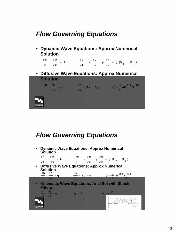
13
Flow Governing Equations
• Dynamic Wave Equations: Approx Numerical Solution
• Diffusive Wave Equations: Approx Numerical Solution
)f
S0
(S gx
hg
x
uu
t
u 0
x
Q
t
h−=
∂
∂+
∂
∂+
∂
∂=
∂
∂+
∂
∂
1/2
fS
2/3 AR
n
1 Q fS0S
x
h q
x
Q
t
h=−=
∂
∂=
∂
∂+
∂
∂
Flow Governing Equations
• Dynamic Wave Equations: Approx Numerical Solution
• Diffusive Wave Equations: Approx Numerical Solution
• Kinematic Wave Equations: Anal Sol with Shock Fitting
)f
S0
(S gx
hg
x
uu
t
u 0
x
Q
t
h−=
∂
∂+
∂
∂+
∂
∂=
∂
∂+
∂
∂
1/2
fS
2/3 AR
n
1 Q fS0S
x
h q
x
Q
t
h=−=
∂
∂=
∂
∂+
∂
∂
mh aQ fS0S q
x
Q
t
h===
∂
∂+
∂
∂

14
Flow Governing Equations
• Dynamic Wave Equations: Approx Numerical Solution
• Diffusive Wave Equations: Approx Numerical Solution
• Kinematic Wave Equations: Anal & Approx Num Solutions
)f
S0
(S gx
hg
x
uu
t
u 0
x
Q
t
h−=
∂
∂+
∂
∂+
∂
∂=
∂
∂+
∂
∂
1/2
fS
2/3 AR
n
1 Q fS0S
x
h q
x
Q
t
h=−=
∂
∂=
∂
∂+
∂
∂
mh aQ fS0S q
x
Q
t
h===
∂
∂+
∂
∂
Flow Governing Equations
• Dynamic Wave Equations: Approx Numerical Solution
• Diffusive Wave Equations: Approx Numerical Solution
• Kinematic Wave Equations: Anal & Approx Num Solutions
• Nonlinear Reservoir Equations: Analytical Procedure
)f
S0
(S gx
hg
x
uu
t
u 0
x
Q
t
h−=
∂
∂+
∂
∂+
∂
∂=
∂
∂+
∂
∂
1/2f
S2/3
ARn
1 Q fS0S
x
h q
x
Q
t
h=−=
∂
∂=
∂
∂+
∂
∂
mh aQ fS0S q
x
Q
t
h===
∂
∂+
∂
∂
1/2
0S
2/3 AR
n
1 Q 0 I
dt
ds=−=

15
Flow Governing Equations
• Dynamic Wave Equations: Approx Numerical Solution
• Diffusive Wave Equations: Approx Numerical Solution
• Kinematic Wave Equations: Anal & Approx Num Solutions
• Nonlinear Reservoir Equations: Analytical Procedure
• Empirical Procedures: Rational Formula; Unit Hydrograph; Muskingum Method
)f
S0
(S gx
hg
x
uu
t
u 0
x
Q
t
h−=
∂
∂+
∂
∂+
∂
∂=
∂
∂+
∂
∂
1/2f
S2/3
ARn
1 Q fS0S
x
h q
x
Q
t
h=−=
∂
∂=
∂
∂+
∂
∂
mh aQ fS0S q
x
Q
t
h===
∂
∂+
∂
∂
1/2
0S
2/3 AR
n
1 Q 0 I
dt
ds=−=
Model Complexities Among Physically-Based Models: Most-Least
XP-SWMM
SWMM
PondPack
PCSWMMPRMSXP-SWMM
MUSICKINEROSSWMM
LSPCDWSMHEC-HMSMIKE SHEPCSWMM
HSPFDR3MDR3MCASC2DCASC2D
Nonlinear Reservoir
Kinematic-Analytical
Kinematic-Numerical
Diffusive-Numerical
Dynamic-Numerical

16
Model Complexities: Least Complex Empirical Models
TR-55SEDIMOT III (Subbasin)
STORMIDEALSEDMOT III (Channel)
AGNPSHEC-HMS (Optional)HEC-HMS (Optional)
Rational FormulaUnit Hydrograph Method
Muskingum Method
Model Complexity (x-axis) Versus Accuracy (y-axis)
10987654321
STORMTR-55
1
PondPack2
AGNPS3
SEDIMOT III
IDEAL
4
MUSIC5
HEC-HMSHSPFLSPC
6
KINEROSPRMS
DR3MDR3M-QUAL
7
SWMMPCSWMMXP-SWMM
8
DWSM9
CASC2DGSSHA
MIKE SHE
10

17
Ease of Model Use
ExtensiveGoodGoodGoodGoodLSPC
NormalGoodGoodGoodGoodKINEROS
NormalLimitedFairFairGoodIDEAL
ExtensiveGoodGoodGoodGoodHydroworks
ExtensiveGoodGoodGoodGoodHSPF
NormalGoodGoodGoodGoodHEC-HMS
NormalLimitedNoneFairGoodDWSM
NormalLimitedFairFairFairDR3M
NormalGoodGoodGoodGoodCASC2D
NormalGoodGoodGoodGoodAGNPS
DataSupportInterfaceManualDocModel
Ease of Model Use
NormalPrivatePrivateGoodGoodTR-55NormalGoodGoodGoodGoodXP-SWMM
NormalGoodGoodGoodGoodSWMMNormalGoodGoodGoodGoodSTORMNormalLimitedFairFairGoodSEDIMOT IIINormalGoodGoodGoodGoodPRMSNormalGoodGoodGoodGoodPondPackNormalGoodGoodGoodGoodPCSWMMNormalGoodGoodGoodGoodMUSICExtensiveGoodGoodGoodGoodMOUSETRAPExtensiveGoodGoodGoodGoodMIKE SHEDataSupportInterfaceManualDocModel

18
Conclusions
• Critical evaluations of 21 models documented in matrix forms are useful in knowing the theoretical bases, sophistication levels, complexities, and relative accuracies of those.
Conclusions
• Critical evaluations of 21 models documented in matrix forms are useful in knowing the theoretical bases, sophistication levels, complexities, and relative accuracies of those.
• The matrices provide useful information to managers for making informed decision while selecting a suitable model for a project.

19
Conclusions
• Critical evaluations of 21 models documented in matrix forms are useful in knowing the theoretical bases, sophistication levels, complexities, and relative accuracies of those.
• The matrices provide useful information to managers for making informed decision while selecting a suitable model for a project.
• The evaluations should be considered qualitative and used only for preliminary selection.
• Up-to-date status of the pre-selected models must be checked from all sources before making final selection.
20
Future Direction
• This investigation is simply a beginning and must continue in reviewing applications of the models to show success or failure, data requirement, ease of application, and meeting managers’ needs.
Future Direction
• This investigation is simply a beginning and must continue in reviewing applications of the models to show success or failure, data requirement, ease of application, and meeting managers’ needs.
• Research must also continue towards enhancing the models by combining strengths of different ones or developing supplemental components, testing those on different watersheds and scales, conducting sensitivity analyses, and determining confidence intervals or uncertainty bounds.
21
Future Direction
• This investigation is simply a beginning and must continue in reviewing applications of the models to show success or failure, data requirement, ease of application, and meeting managers’ needs.
• Research must also continue towards enhancing the models by combining strengths of different ones or developing supplemental components, testing those on different watersheds and scales, conducting sensitivity analyses, and determining confidence intervals or uncertainty bounds.
• Complete and transparent documentations of the models and extensive education and trainings are required for technology transfer to the managers.
THANK YOU!

Watershed Models for Stormwater Management: A Review for Better Selection and Application Woolpert, Inc. Deva K. Borah, Ph.D., P.E. and Jamie H. Weist, P.E. 1
WATERSHED MODELS FOR STORMWATER MANAGEMENT: A REVIEW FOR BETTER SELECTION AND APPLICATION Deva K. Borah, Ph.D., P.E. and Jamie H. Weist, P.E. Woolpert, Inc. 415 Port Centre Parkway, Suite 101, Portsmouth, VA 23704-4929
Abstract
Many watershed models are available today and those are diverse with various complexities, strengths, and weaknesses. The objective is to review available watershed models for stormwater management and provide useful information and understanding of those for the end users, particularly the managers, so that an informed decision in selecting a model suitable for an application can be derived. Twenty one watershed models simulating storm event runoff including sediment and chemicals were reviewed and evaluated resulting in the development of four matrices: (1) model summaries, (2) model complexities, (3) relative accuracies, and (4) ease of model use. Emphasis was placed on theoretical bases, sophistication levels, and relative accuracies. The evaluations documented in the matrices are informative and useful to the managers, however, should be considered qualitative and only used in preliminary screening.
Introduction
Watershed models are useful analysis tools to interpret, quantify, and assess complex natural processes, such as stormwater runoff resulting from precipitation (hydrologic cycle), erosion of upland soil and stream bed and bank, sedimentation, and contamination of runoff from naturally-produced or human-induced chemicals. The models are useful to evaluate alternative land uses (changes), best management practices (BMPs), and towards solving or alleviating potential problems, such as flooding, excessive erosion, sedimentation, and water pollution (water quality), which are critical environmental, social, and economic problems.
Many watershed models have been developed and numerous modeling studies have been conducted on stormwater management using primarily a few of the more popular models. After completing an extensive and expensive modeling project, disappointments do occur from time to time including models not performing to the expectations or not to the level it was presented. A question often asked: was the right model selected? In fact, selecting the most suitable model to accomplish a project most accurately and efficiently as possible is a challenging task. A clear understanding of the models, including their capabilities and limitations, is critical in selecting the most suitable model for a project, utilizing its maximum potential, and avoiding any misuses.
The models available today are diverse. They are based on a variety of concepts, principles, and formulations while mathematically simulating (mimicking) the natural processes of a stormwater drainage system resulting in various complexities, strengths, and weaknesses. Some models are based on simple empirical relationships having robust algorithms, and others use physically-based governing equations generally having computationally-intensive numerical solutions. Simple models are often incapable of giving desirable detailed results and detailed models can be inefficient or prohibitive for certain (e.g., large) watersheds. Selecting the most appropriate model to achieve the most accurate and efficient solution possible is a challenging task. A few of the models offer balances or compromises between the complexities, however, disadvantages do exist, e.g., lack of interfaces.

Watershed Models for Stormwater Management: A Review for Better Selection and Application Woolpert, Inc. Deva K. Borah, Ph.D., P.E. and Jamie H. Weist, P.E. 2
Meeting the needs of the end-users, the water resources managers, and their primary concerns of cost-benefits, model diversities (multiple use potentials), accuracies or uncertainties against details , sharing models with other entities, operation and maintenance using internal staff or consultants, and effective communications (interpretation) with stakeholders, make the selection process even more challenging.
The objective of this investigation is to review watershed models for stormwater management and provide useful information and understanding of the models for the end users, particularly the managers, so that an informed decision in selecting a model suitable for an application can be derived. Twenty one watershed models simulating storm event runoff including sediment and chemicals were reviewed and evaluated resulting in the development of four matrices: (1) model summaries, (2) model complexities, (3) relative accuracies, and (4) ease of model use. Emphasis was placed on theoretical bases, sophistication leve ls, and relative accuracie s of the models.
These investigations were based on information available in the literature. Only the models having capabilities to simulate single storm events were investigated. Models having only continuous simulation capabilities, even the ones widely used were not included. The evaluations made in the matrices should be considered qualitative and only used in preliminary screening of the models. After narrowing the choices, the users must check the current status of each of the models from all possible sources before making a final selection.
A full report on the investigation is in progress (Borah et al., 2008) although this is just a beginning. Investigations must continue towards meeting the needs and expectations of the managers.
Watershed Model Users Perspectives
The water resource managers are primarily the end users of watershed models. Meeting the needs and concerns of the end-users is a key factor in the model selection process. From a manager’s perspective, funding, integration, interface, interpretation, and range of applicability are key factors when determining which stormwater model should be selected. Funding of stormwater modeling is determined as a result of needs versus return on investment. Managers prefer to know if the model is proprietary (licensing cost) and how often it is updated (maintenance agreement costs). Integration of the selected model with the organization’s existing and significantly invested software (e.g., Geographic Information System or GIS) is critical. User interface and “ease of use” of a model for managers, who are typically not as technically diverse as their staff, is important, and managers prefer models they and the general public can comprehend. This is particularly important if the model will be made available to outside consultants and developers for use. Knowing the model’s limitations and intended use are keys to determining which model should be selected.
In addition, the managers like to know reasons for modeling, value of the model-derived decision (planning, design, or for establishing flood plains or overland relief), appropriate watershed sizes the models were developed for and tested, quantity (flow) or quality (sediment and pollutants) prediction capabilities, hardware needed and their costs, type of input data and the way they are used, output results, importance and ease of calibration, level of accuracy expected or needed, guarantee of better results with detailed information-data or model sophistication, model capability of running alternatives, project specific or diversity of the models for continuing applications, abilit y to share with developers and other engineers, and ease of operation and maintenance by internal staff or requiring consultant’s services.
Watershed Model Evaluations for Stormwater Management
Twenty one watershed models simulating storm event runoff as well as sediment and chemicals were reviewed and evaluated. Four matrices were developed and presented in Tables 1-4. Table 1 presents
Watershed Models for Stormwater Management: A Review for Better Selection and Application Woolpert, Inc. Deva K. Borah, Ph.D., P.E. and Jamie H. Weist, P.E. 3
model summaries: source, public domain or proprietary status, model type based on dominant land use, watershed size limit , and model category based on simulation capabilities. Table 2 divides the models based on theoretical bases and model complexities. Table 3 is a 2-dimensional matrix showing the models’ relative accuracies with respect to the relative complexities. In Table 3, three different colors are used for the models to distinguish their categories. Table 4 indicates qualitatively relative ease of model use having documentation, user manual, interface, technical support, and data requirement for the models.
The matrices in Tables 2 and 3 are based solely on hydrologic/hydraulic (water) simulations of the models, specifically the flow routing procedures. Hydrology and hydraulic simulations are the basis for sediment and water quality simulations and, therefore, are key components to the performance of a model. Within the hydrologic and hydraulic simulations, flow routing is the key component with a profound bearing on maintaining the dynamics of a watershed. The physical basis of a model is determined mainly on the flow routing component. The remaining components are mostly based on empirical relations or parameters, even with physically-based equations (e.g., infiltration and sediment transport), which are dominated by empirical coefficients or parameters.
Model Summaries
Table 1 summarizes all the 21 models reviewed in an alphabetical order. The abbreviated and full names of the models are given in column 1. Respective model sources or developers are listed in column 2. Proper references are cited with the sources however references of models whose information are readily available in the internet are avoided for space limitations. Column 3 lists the public -domain, proprietary, mixed (partly both) or undefined status of the models. Model types based on dominant land uses the model are capable of simulating, specifically urban and agricultural, are given in column 4. Some models are not specific to any of the land uses, termed here as general, and can be used for any combination of land uses, including agricultural, urban, suburban, and rural, up to a certain level. Column 5 shows the applicable size limits of the watersheds. The modeled watersheds are divided into three broad size groups: small with less than 10 mi2, medium in between 10 mi2 and 100 mi2 , and large with more than 100 mi2. Column 6 groups the models into broad categories according to combinations of their simulation capabilities.

Watershed Models for Stormwater Management: A Review for Better Selection and Application Woolpert, Inc. Deva K. Borah, Ph.D., P.E. and Jamie H. Weist, P.E. 4
Table 1. Summary of watershed models for stormwater management.
Model Source* Public domain or proprietary
Model type (land use )
Watershed size limit
Model category & capabilities
AGNPS: AGricultural NonPoint Source
U.S. Dept. of Agriculture-Ag Res Service (USDA-ARS)
Public domain
Agricultural Medium up to 80 mi2
Hydro, sediment, and chemical
CASC2D/GSSHA : CASCade of planes in 2-D/Gridded Surf-Subsurf Hydro Anal
U.S. Army Corps of Engineers (USACE)
Partly both General Small less than 10 mi2
Hydro and sediment
DR3M/DR3M-QUAL: Distributed Routing Rainfall Runoff Model
U.S. Geological Service (USGS)
Public domain
Urban Small less than 10 mi2
Hydro, sediment, and chemical
DWSM: Dynamic Watershed Simulation Model
Woolpert/Borah (Borah et al., 2002)
Undefined; contact developer
General Large over 100 mi2
Hydro, sediment, and chemical
HEC-HMS: Hydro Engineering Center-Hydro Mod System
USACE-HEC Public domain
General Small to medium up to 40 mi2
Hydro
HSPF: Hydrological Simulation Program-Fortran
U.S. Environmental Protection Agency (USEPA)
Public domain
General Large over 100 mi2
Hydro, sediment, and chemical
Hydroworks Wallingford Software
Proprietary Urban Small up to 2.4 mi2
Hydro, sediment, and chemical
IDEAL: Integrated Design & Evaluation Assessment of Loading
Barfield et al. (2006a)
Undefined; contact developer
Urban Small developed areas up to a few mi2
Hydro, sediment, and chemical
KINEROS: KINematic runoff & EROSion
USDA-ARS Public domain
General Small up to 4 mi2
Hydro and sediment
LSPC: Loading Simulation Program in C++
USEPA Public domain
General Large over 100 mi2
Hydro, sediment, and chemical
Note: *References of models readily available in the internet are avoided for space limitations.

Watershed Models for Stormwater Management: A Review for Better Selection and Application Woolpert, Inc. Deva K. Borah, Ph.D., P.E. and Jamie H. Weist, P.E. 5
Table 1. Summary of watershed models for stormwater management (Continued).
Model Source* Public domain or proprietary
Model type (land use)
Watershed size limit
Model category & capabilities
MIKE SHE: Système Hydro Européen
Danish Hydraulic Institute
Proprietary General Large over 100 mi2
Hydro, sediment, and chemical
MOUSETRAP: Model of Urban Sewers & Transport
Danish Hydraulic Institute
Proprietary Urban & sewer
Small: 3 mi sewer
Hydro, sediment, and chemical
MUSIC: Model for Urban Stormwater Improve Concept
Monash University, Australia
Proprietary Urban Medium up to 100 mi2
Hydro, sediment, and chemical
PCSWMM: Personal Computer Storm Water Management Model
Computational Hydraulics International
Proprietary Urban Commonly small to medium up to 10 mi2
Hydro, sediment, and chemical
PondPack : Pond Simulation Package
Haestad Methods
Proprietary Urban Small developed areas up to a few mi2
Hydro
PRMS: Precipitation-Runoff Modeling System
USGS Public domain General Large over 100 mi2
Hydro and sediment
SEDIMOT III: Sedi-mentology by Distri-buted Modeling Tech
Barfield et al. (2006b)
Undefined; contact developer
General Small less than 1 mi2
Hydro and sediment
STORM: Storage Treatment Overflow Runoff Model
USACE-HEC Public domain Urban Small less than 10 mi2
Hydro, sediment, and chemical
SWMM: Storm Water Management Model
USEPA Public domain Urban Commonly small to medium up to 10 mi2
Hydro, sediment, and chemical
TR-55: Tech Release 55: Urban Hydro for Small Watersheds
USDA-NRCS (USDA-SCS, 1986)
Public domain Urban Small less than 10 mi2
Hydro
XP-SWMM: Expert Storm Water Management Model
XP Software, Inc. Proprietary Urban Commonly small to medium up to 10 mi2
Hydro, sediment, and chemical
Note: *References of models readily available in the internet are avoided for space limitations.
Model Complexities and Accuracies
Table 2 groups the models according to their various theoretical bases and complexities solely based on the water routing schemes. The water routing scheme is mainly responsible for accounting the watershed dynamics in a model, and therefore, it determines the level of physical bases of the model.

Watershed Models for Stormwater Management: A Review for Better Selection and Application Woolpert, Inc. Deva K. Borah, Ph.D., P.E. and Jamie H. Weist, P.E. 6
The physically-based flow-governing equations are the continuity (conservation of mass) and momentum (conservation of momentum) equations for shallow water flows and are commonly known as the St. Venant or the dynamic wave equations. A model using these equations to route water over land surfaces and through channels would be considered the most physically-based model and the flows simulated by such model would be considered the most accurate predictions. Unfortunately, there is no analytical solution of these equations to compute the flows directly. Approximate numerical solutions (indirect methods) are used to solve these equations which bring complexities and challenges, such as numerical errors and numerical instabilities.
Models resulting from the dynamic wave equations turn out to be the most complex models. However, due to the approximations and complex solution paths, the simulated flows may not turn out to be the most accurate predictions. These equations are not commonly used in watershed models. CASC2D/GSSHA, PCSWMM, SWMM, and XP-SWMM use those equations to simulate channels only. CASC2D/GSSHA uses these limitedly, only for mild-sloped channels.
In order to get some relief from the solution complexities, approximations are used to eliminate some of the terms and simplify the dynamic wave equations. The next simplified flow governing equations are the diffusive wave equations (Table 2), which do not have analytical solutions either and must be solved using approximate numerical procedures. However, these solutions are not as complex as solutions to the full dynamic wave equations. CASC2D/GSSHA and MIKE SHE use the diffusive wave equations for both overland and channel flow routings.
The third and the most simplified form of the dynamic wave equations are the kinematic wave equations preserving some dynamics under conditions mostly present in upland watersheds with the exceptions of downstream control and backwater to route or simulate spatial and temporal variability of water flow in the form of waves. The equations have an analytical solution limited by shocks under shock-forming conditions, where the solution is no longer valid. Therefore, some models, such as HEC-HMS, KINEROS, and PRMS (Table 2) use approximate numerical solutions to solve the kinematic wave equations, where the shock is not an issue. These models do not get the benefits in terms of accuracy and speed (efficiency) of the analytical solution. Some models do take advantage of the analytical solution. DR3M/DR3M-QUAL uses the analytical solution where shocks are not present, generally on overland surfaces, but use approximate numerical solution to other conditions, mostly channels. DWSM is the only model that takes advantage of the analytical solution throughout the entire watershed simulation by introducing an approximate shock-fitting solution to simulate under shock-forming conditions, which happen sometime under sudden change of channel grade from steeper to flatter and only during a narrow sharp rising part of the hydrograph.

Watershed Models for Stormwater Management: A Review for Better Selection and Application Woolpert, Inc. Deva K. Borah, Ph.D., P.E. and Jamie H. Weist, P.E. 7
Table 2. Model complexities (theoretical bases) in descending order from left to right based on hydrologic/hydraulic routing
Dynamic wave equations by numerical solution
Diffusive wave equations by numerical solution
Kinematic wave equations by numerical solution
Kinematic wave equations by analytical solution
Nonlinear reservoir equations
Muskingum method
Unit hydrograph
Rational formula or its modifica-tions
CASC2D/GSSHA (some channels)
CASC2D/GSSHA (overland and channel)
DR3M/ DR3M-QUAL (channel)
DR3M/ DR3M-QUAL (overland)
HSPF HEC-HMS (optional)
HEC-HMS (optional)
AGNPS
PCSWMM (channel option)
MIKE SHE HEC-HMS (optional)
DWSM LSPC SEDIMOT III (channel)
IDEAL STORM
SWMM (channel option)
KINEROS MUSIC SEDIMOT III (subwater-shed)
TR-55
XP-SWMM (channel option)
PRMS PCSWMM
PondPack SWMM XP-SWMM
Note: No information on Hydroworks and MOUSETRAP.
The next simplified level of equations is the nonlinear reservoir equations (Table 2), which use the continuity equation of a level water surface and an empirical equation to compute the flow. Although the solution of these equations is spatially uniform assuming the overland and channel flow segments as a series of reservoirs, it conserves mass and the models using it (Table 2) are considered physically-based. They are less complex and less accurate than the kinematic, diffusive, or dynamic wave equations.
The remaining routing procedures, Muskingum method, unit hydrograph method, and the Rational formula or its modifications are conceptual and empirical, and the models (Table 2) using these are less complex and perhaps less accurate because of not using one of the physically-based flow governing equations.
Based on these discussions on model complexities and anticipated accuracies, the models are placed on a 2-dimensional matrix on Table 3. The x-axis represents model complexities in a scale of 1 to 10, 1 being the least and 10 being the most complex model. Similarly the y-axis represents model accuracies, 1 being the least and 10 being the most accurate model. This is an attempt to evaluate the relative built-in accuracies of the models with respect to the most influencing components, the water routing schemes. These are qualitative assessments and evaluations for initial screening of the models. Different colors are used in the table to identify the three different model categories.
Ease of Model Use
Table 4 gives a rough idea about the models towards ease of their applications or user-friendliness based on documentation, user manual, interface, technical support, and data requirement. Qualitative statements, such as good, fair, limited, normal, and extensive are used. Many models, such as TR-55, developed by Federal agencies are also available commercially with user-friendly interfaces and technical support.

Watershed Models for Stormwater Management: A Review for Better Selection and Application Woolpert, Inc. Deva K. Borah, Ph.D., P.E. and Jamie H. Weist, P.E. 8
Summary and Conclusions
Twenty one watershed models simulating storm event runoff as well as sediment and chemicals were reviewed, evaluated, and documented in four matrices. The matrices are useful in knowing the models better, especially the theoretical bases, sophistication levels or complexities, and relative accuracies, key information not easily available.
The matrices provide useful information for end users of the models, particularly the managers, to make informed decision in selecting a model suitable for an application or project.
The evaluations documented in the matrices should be considered qualitative and only used in preliminary screening. After narrowing the choices, users must check current status of the models from all sources before making a final selection.
This investigation is simply a beginning and must continue in reviewing applications of the models to show success or failure, data requirement, ease of application, and meeting the needs and expectations of the end users.
References
Barfield, B. J., J. C. Hayes, S. L. Harp, K. F. Holbrook, and J. Gillespie. 2006a. Chapter 15: IDEAL: Integrated Design and Evaluation Assessment of Loadings Model. In Watershed Models, 361-379. V. P. Singh and D. K. Frevert, eds. CRC Taylor and Francis, Boca Raton, Fla.
Barfield , B. J., J. C. Hayes, E. Stevens, S. L. Harp, and A. Fogle 2006b. Chapter 16: SEDIMOT III Model. In Watershed Models, 381-398. V. P. Singh and D. K. Frevert, eds. CRC Taylor and Francis, Boca Raton, Fla.
Borah, D. K., R. Xia, and M. Bera. 2002. Chapter 5: DWSM - A dynamic watershed simulation model. In Mathematical Models of Small Watershed Hydrology and Applications, 113-166. V. P. Singh and D. K. Frevert, eds. Highlands Ranch, Colo.: Water Resources Publications.
Borah, D.K., J.H. Weist, J. Wall, G. Yagow, S. Mostaghimi, and R.W. Bartlett. 2008. Watershed models for stormwater management: Review and Evaluation for Better Selection and Application. Manuscript under preparation for the Transactions of the ASABE.
USDA-SCS. 1986. Urban Hydrology for Small Watersheds. Technical Release 55, U.S. Department of Agriculture – Soil Conservation Service, Washington, D.C.

Watershed Models for Stormwater Management: A Review for Better Selection and Application Woolpert, Inc. Deva K. Borah, Ph.D., P.E. and Jamie H. Weist, P.E. 9
Table 3. Model complexity (x-axis) versus accuracy (y-axis) based on hydrologic/hydraulic routing
10 CASC2D GSSHA MIKE SHE
9 DWSM
8 SWMM PCSWMM XP-SWMM
7 DR3M DR3M-QUAL
KINEROS PRMS
6 HSPF LSPC
HEC-HMS
5 MUSIC
4 SEDIMOT III
IDEAL
3 AGNPS
2 PondPack
1 STORM TR-55
1 2 3 4 5 6 7 8 9 10
Note: Blue: Hydro ; Brown: Hydro & sediment; Red: Hydro, sediment, & chemical

Watershed Models for Stormwater Management: A Review for Better Selection and Application Woolpert, Inc. Deva K. Borah, Ph.D., P.E. and Jamie H. Weist, P.E. 10
Table 4. Ease of model use
Model Documentation User manual
Interface Technical support
Data requirement
AGNPS Good Good Good Good Normal CASC2D/GSSHA Good Good Good Good Normal DR3M/DR3M-QUAL
Fair Fair Fair Limited Normal
DWSM Good Fair None Limited Normal HEC-HMS Good Good Good Good Normal HSPF Good Good Good Good Extensive Hydroworks Good Good Good Good Extensive IDEAL Good Fair Fair Limited Normal KINEROS Good Good Good Good Normal LSPC Good Good Good Good Extensive MIKE SHE Good Good Good Good Extensive MOUSETRAP Good Good Good Good Extensive MUSIC Good Good Good Good Normal PCSWMM Good Good Good Good Normal PondPack Good Good Good Good Normal PRMS Good Good Good Good Normal SEDIMOT III Good Fair Fair Limited Normal STORM Good Good Good Good Normal SWMM Good Good Good Good Normal TR-55 Good Good Commercial
version Commercial version
Normal
XP-SWMM Good Good Good Good Normal