Embed Size (px)
Citation preview
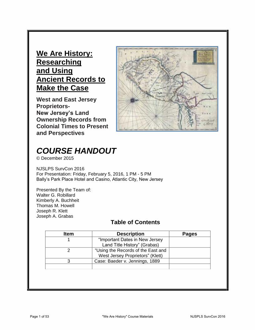
We Are History: Researching and Using Ancient Records to Make the Case
West and East Jersey Proprietors- New Jersey’s Land Ownership Records from Colonial Times to Present and Perspectives
COURSE HANDOUT © December 2015 NJSLPS SurvCon 2016 For Presentation: Friday, February 5, 2016, 1 PM - 5 PM Bally’s Park Place Hotel and Casino, Atlantic City, New Jersey Presented By the Team of: Walter G. Robillard Kimberly A. Buchheit Thomas M. Howell Joseph R. Klett Joseph A. Grabas
Table of Contents
Item Description Pages 1 “Important Dates in New Jersey
Land Title History” (Grabas)
2 “Using the Records of the East and West Jersey Proprietors” (Klett)
3 Case: Baeder v. Jennings, 1889
Page 1 of 53 "We Are History" Course Materials NJSPLS SurvCon 2016
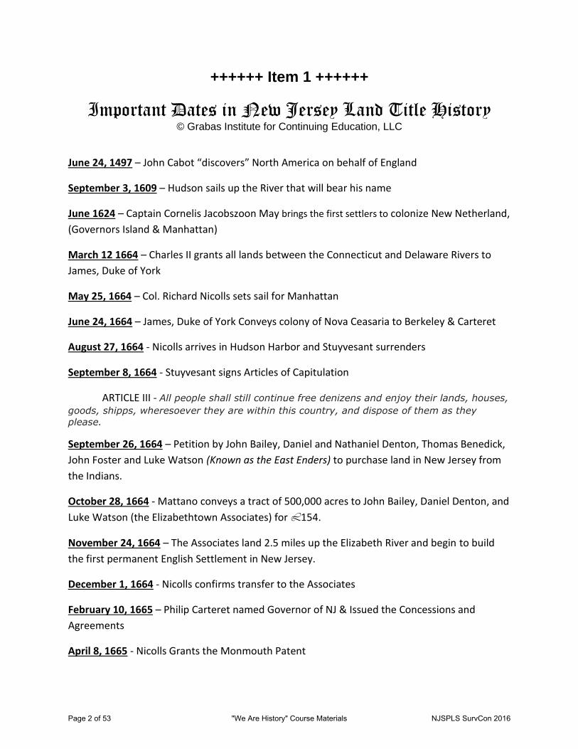
++++++ Item 1 ++++++
Important Dates in New Jersey Land Title History © Grabas Institute for Continuing Education, LLC
June 24, 1497 – John Cabot “discovers” North America on behalf of England
September 3, 1609 – Hudson sails up the River that will bear his name
June 1624 – Captain Cornelis Jacobszoon May brings the first settlers to colonize New Netherland,
(Governors Island & Manhattan)
March 12 1664 – Charles II grants all lands between the Connecticut and Delaware Rivers to
James, Duke of York
May 25, 1664 – Col. Richard Nicolls sets sail for Manhattan
June 24, 1664 – James, Duke of York Conveys colony of Nova Ceasaria to Berkeley & Carteret
August 27, 1664 - Nicolls arrives in Hudson Harbor and Stuyvesant surrenders
September 8, 1664 - Stuyvesant signs Articles of Capitulation
ARTICLE III - All people shall still continue free denizens and enjoy their lands, houses,
goods, shipps, wheresoever they are within this country, and dispose of them as they
please.
September 26, 1664 – Petition by John Bailey, Daniel and Nathaniel Denton, Thomas Benedick,
John Foster and Luke Watson (Known as the East Enders) to purchase land in New Jersey from
the Indians.
October 28, 1664 - Mattano conveys a tract of 500,000 acres to John Bailey, Daniel Denton, and
Luke Watson (the Elizabethtown Associates) for L154.
November 24, 1664 – The Associates land 2.5 miles up the Elizabeth River and begin to build
the first permanent English Settlement in New Jersey.
December 1, 1664 - Nicolls confirms transfer to the Associates
February 10, 1665 – Philip Carteret named Governor of NJ & Issued the Concessions and
Agreements
April 8, 1665 - Nicolls Grants the Monmouth Patent
Page 2 of 53 "We Are History" Course Materials NJSPLS SurvCon 2016
August 1, 1665 – Governor Philip Carteret arrives in New Jersey at Elizabethtown and Purchases
a share becoming an Associate.
February 19, 1666 – The Settlement is named Elizabethtown in honor of the wife of Sir George
Carteret
May 25, 1668 – The First New Jersey Assembly meets in Elizabethtown.
March 25, 1670 - Carteret demands payment of Quit Rents, one half penny per acre, per year.
June 20, 1671 – Rioters “pull up” Michell’s fence
May 14, 1672 – Capt. James Carteret, son of Sir George Carteret is elected “President” of New
Jersey by an ad hoc Assembly and usurps his cousin Philip Carteret’s authority.
July 1, 1672 – A dejected Philip Carteret returns to England
July 16, 1672 – The Second Dutch War was declared in NJ
July 30, 1673 – The Dutch recapture NY & NJ
February 9, 1674 – Peace Treaty - The English regain NJ by “right of conquest.”
March 1674 – Berkeley sells his half interest in New Jersey to Edward Byllynge and Maj. John
Fenwick for L1000.
June 29, 1674 – Charles II reconfirms his Grant to the Duke of York
July 28, 1674 – Duke of York reconfirms his Grant to Carteret only
November 1674 – Governor Philip Carteret returns to NJ with Letter from Geo Carteret
nullifying the Nicolls Grants.
July 1, 1676 – Quintipartitite (Five Parties) Deed/Agreement is signed by George Carteret,
William Penn, Edward Byllynge, Gawen Laurie and Nicholas Lucas
January 14, 1680 – George Carteret Dies
April 1680 – NY Governor Edmund Andros kidnaps and beats Philip Carteret while arresting him
for trial in NY. The NY jury acquits Carteret, but he agrees not to resume his position as
Governor of NJ.
1682 – East Jersey sold at auction for L3400 to 12 Proprietors led by William Penn
Page 3 of 53 "We Are History" Course Materials NJSPLS SurvCon 2016
December, 1682 – Philip Carteret dies at the age of 44 in Elizabethtown from injuries inflicted
by Andros and his men.
1695 - Fullerton v Jones (Proprietory Court ruled against Jones (Associate) King and Council
reversed on appeal)
April 15, 1702 – Proprietors surrender rights of government
December 5, 1702 – Edward Hyde, Lord Cornbury was named Royal Governor of NY & NJ
Clinker Lot Right Men claim Western lands
April 17, 1745 - Elizabethtown Bill in Chancery
September 20, 1745 – Newark “Horseneckers” storm the jail and free Samuel Baldwin,
squatter.
January 17, 1746 – Newark mob confronts the Sheriff and the Militia and storms the jail again
to free fellow rioters.
August 5, 1746 – Magdalena Valleau and an armed mob of 40, drive Edward Jeffers out of his
home and off his land in the disputed Ramapo Tract.
July 17, 1747 – 200 rioters led by Amos Roberts “King of the Rioters, marched on Perth Amboy,
fully armed and attacked the jail
February 17, 1748 – NJ Assembly approves an Act of pardon for the rioters.
August, 1751 – Elizabethtown Associates file answer to Bill (Never Judicially settled)
1755 – Abraham Clark, future signer of the Declaration of Independence, leads a group of
Elizabethtown men in a fight to reclaim Morgan’s Mine on the Middlesex-Somerset border,
asserting ownership by virtue of the Nicoll’s Grant.
September 1, 1773 – By Royal Edict King George approves and sets the Northern boundary of
NJ.
July 2, 1776 – New Jersey’s First Constitution
July 4, 1776 – Declaration of Independence
June 28, 1834 – NY and NJ Agree that Staten Island belongs to NY
Page 4 of 53 "We Are History" Course Materials NJSPLS SurvCon 2016
Using the Records of the East and West Jersey Proprietors
by
Joseph R. Klett NEW JERSEY STATE ARCHIVES
© 2014
as revised
Page 5 of 53 "We Are History" Course Materials NJSPLS SurvCon 2016
USING THE RECORDS OF THE EAST AND WEST JERSEY PROPRIETORS
PRESENTATION OUTLINE
I. Introduction Page 1 II. Important Events in New Jersey’s Proprietary History Page 3 III. The East-West Boundary Page 7 IV. East Jersey’s Earliest Settlements Page 9 V. West Jersey’s Earliest Settlements Page 12 VI. Key Terms and Document Types Page 14 VII. How was Land Acquired? Page 17 VIII. Proprietors’ Records available at New Jersey State Archives Page 18 IX. Legal, Obscure and Archaic Terms found in Ancient Land Records Page 26 X. Case Studies Page 34 XI. Bibliography Page 35
Acknowledgments
The author thankfully acknowledges the following persons who aided in the preparation of these materials:
Ellen R. Callahan, Collection Manager at the New Jersey State Archives, for documentary and bibliographic research assistance.
William H. Taylor, Surveyor General of West New Jersey, and the late Frederick A. Gerken, Registrar of the Eastern Division of New Jersey, for imparting some of their knowledge of proprietary records and history.
John E. Pomfret and John P. Snyder for their invaluable reference works, including Mr. Snyder’s original maps donated years ago to the New Jersey State Archives.
Joanne M. Nestor, Photographic Archivist at the New Jersey State Archives, for scanning documents and maps.
Various staff and colleagues who reviewed and contributed to the list of terms found in land records.
Page 6 of 53 "We Are History" Course Materials NJSPLS SurvCon 2016
Using the Records of the East and West Jersey Proprietors by Joseph R. Klett, New Jersey State Archives Page 1
Part I – Introduction
Who Were (Are) the Proprietors?
Based on the joint rights granted by the Duke of York to Sir George Carteret and John, Lord Berkeley, New Jersey became a proprietary colony with eastern and western divisions. East Jersey’s development was tied to New York, New England, and the former Dutch colony of New Netherland. The settlement of West Jersey on the Delaware River was initially a Quaker venture, and was associated with William Penn and others involved in the colonization of Pennsylvania.
The successors to Carteret’s and Berkeley’s interests in New Jersey essentially evolved into the corporate East and West Jersey Proprietors, respectively. They were the first British landowners of New Jersey, and governed the provinces during the first four decades of British colonization. In 1702, after the proprietors in East and West Jersey had surrendered their governmental authority several times, Queen Anne established New Jersey as a unified royal colony. The proprietors nevertheless retained their land rights. The provincial dual capitals of Perth Amboy in East Jersey and Burlington in West Jersey also continued as the seats of government until Trenton became the state capital in 1790.
In 1998, the East Jersey Proprietors—reportedly New Jersey’s oldest corporation—dissolved and sold their rights to unappropriated land to the state’s Green Acres program. At that time, the East Jersey records were transferred from Perth Amboy to the State Archives in Trenton. In December 2005, the West Jersey Proprietors deposited their records with the State Archives as well, thus uniting all of New Jersey’s colonial land records under one roof. The West Jersey Proprietors continue as an active corporation based in Burlington, N.J., and retain legal ownership of their original records.
And Why do you Care?
The records of the East and West Jersey Proprietors document nearly three and a half centuries of land transactions and settlement in New Jersey. While the earliest volumes of proprietary land records and government commissions were united in the office of the Secretary of State at the time or soon after Trenton was established as the state capital in 1790, a large volume of books containing just surveys or warrants and certain other early records were retained by the proprietors.
Since the recording of land conveyances is and has always been voluntary, and since this function was not fully available in the county seats until 1785 for deeds and 1766 for mortgages, proprietary survey records are vital for documenting colonial land-owning families. Throughout the records are buried innumerable genealogical facts and connections. Since very little has been published in terms of abstracts or transcripts of the proprietors’ books, serious research requires using the original documents (on microfilm).
Genealogical documentation aside, a basic knowledge of the East and West Jersey proprietors and the partition lines between the two provinces will aid any genealogist researching colonial New Jersey families. The original counties and their boundaries and subdivisions were based on the east-west division, and references to the two regions are prevalent in land, estate, court and legislative records through to the revolutionary period and later.
Several major indexes to proprietary surveys are available at the State Archives, and we have produced or are in the process of creating databases that further catalog and index these records. Improving access to the proprietary records is one of the State Archives’ highest processing priorities.
Page 7 of 53 "We Are History" Course Materials NJSPLS SurvCon 2016
Using the Records of the East and West Jersey Proprietors by Joseph R. Klett, New Jersey State Archives Page 2
East Jersey versus West Jersey While the proprietary systems that evolved in East and West Jersey had much in common, there were marked differences in terms of the development of the two divisions of the colony and the relationship between the settlers and the proprietors. In East Jersey, patents had been granted independently by Governor Nicolls to colonists from New England and New York, setting the stage for major and ongoing disagreements. These disputes related to the very right of the proprietors to govern, the collection of quit-rents, the granting of unsettled lands within the Nicolls patents, and the means of funding government. East Jersey also was subject to customs-related challenges and annexation efforts on the part of New York. As a result of these controversies, settlement in East Jersey during the proprietary period was slower than had been anticipated.
The disputes related to land rights and quit-rents plagued East Jersey throughout the proprietary period and beyond the 1702 surrender of governing rights. The controversy over lots granted by the Elizabeth-Town Associates, culminating in the 1745 Bill in Chancery and its answer, is a reminder that even after the East Jersey Proprietors were no longer a governmental authority they were still at odds with a proportion of the settlers to the end of colonial times.
In West Jersey, where shares were divided into smaller fractions, there was greater opportunity for persons other than the extremely wealthy to hold stock in the colony and its land. Quit-rents were not required in much of West Jersey due to the wider distribution of land rights and the resultant competition for sales to settlers. While West Jersey’s governors Edward Byllynge and Daniel Coxe often acted in conflict with the chartering Concessions and Agreements (which Byllynge himself had written), the democratic ideals found in this document had a positive influence on the relationship between the settlers and the proprietors.
While members of the Society of Friends (including William Penn) were involved in the development of East Jersey and were in large numbers among its settlers, the initial English colonization of West Jersey was essentially a Quaker venture. In fact, many of the problems that arose in West Jersey toward the end of the proprietary period were connected to non-Quaker forces—in particular Dr. Daniel Coxe, the West Jersey Society (which acquired land and governance rights from Coxe), and the Society’s agents. Overall, West Jersey was a more peaceful province with a more open proprietorship.
It is of interest to note that there are also differences between the types of records kept by the East and West Jersey proprietors respectively. In East Jersey, the early proprietorship was characterized by contention over quit-rents and a need for defense of proprietary land rights. It is not surprising, therefore, that among East Jersey’s archive are certain record types not found in West Jersey, such as quit-rent accounts and exemplified copies (abstracts) of the earliest deed books—the originals having been taken over by the colonial government before 1741.
On the other hand, in West Jersey proprietary rights were divided into smaller fractions. There were (are) hypothetically 3,200 voting shares as compared to ninety-six in East Jersey, although many West Jersey shares have never been accounted for. In theory then (since the main purpose of proprietary records is to document land surveys and the initial severance of title from the proprietors), the West Jersey records might contain buried genealogical data pertaining to a greater number of families.
The proprietary records—from both East and West—are nevertheless vital to research on colonial New Jersey families. Both archives contain extensive and as yet unpublished documentation from the seventeenth century. Obviously, the largely untapped historical and genealogical research potential of the proprietary land records is vast indeed.
Page 8 of 53 "We Are History" Course Materials NJSPLS SurvCon 2016
Using the Records of the East and West Jersey Proprietors by Joseph R. Klett, New Jersey State Archives Page 3
Part II –Important Events in New Jersey’s Proprietary History The following timeline is adapted primarily from John E. Pomfret, The New Jersey Proprietors and Their Lands, 1664-1776 (Princeton, 1964) and John P. Snyder, The Story of New Jersey’s Civil Boundaries, 1606-1968 (Trenton, 1969). A short list of important years to remember is included at the end. NOTE: The years as given are based on the modern calendar. 29 May 1660 – King Charles II restored to the throne in England; resolves to bring the New Netherland colony into the dominion of the British crown.
12 March 1664 – King Charles issues patent bestowing upon his brother James, Duke of York, the land extending from the St. Lawrence River to the Delaware. Included are Maine, Martha’s Vineyard, Nantucket, Long Island, and the mainland between the Connecticut and Delaware rivers (containing New York and New Jersey).
23-24 June 1664 – Duke James grants lands between the Hudson and Delaware rivers to loyal friends John, Lord Berkeley, and Sir George Carteret (both also proprietors of the Carolinas). The colony is to be called New Jersey or New Cesarea in honor of Carteret’s homeland, the Isle of Jersey in the English Channel.
18 August 1664 – Four British frigates arrive at New Amsterdam; the Dutch surrender. Col. Richard Nicolls is established as governor of the Duke’s territories. New Amsterdam is renamed New York; New Jersey is called Albania by the local English.
late 1664 – Gov. Nicolls issues conditions upon which plantations would be created.
1 December 1664 – Gov. Nicolls grants patent for settlement on Achter Koll (Newark Bay), subsequently called Elizabeth-Town, which had been purchased from the Indians on 28 October by John Ogden, Luke Watson and others.
10 February 1665 – Berkeley and Carteret publish Concessions and Agreements based on Carolina’s concessions.
8 April 1665 – Gov. Nicolls grants patent for Navesink/Monmouth tract (Middletown and Shrewsbury settlements).
August 1665 – Capt. Philip Carteret, cousin of Sir George’s wife Elizabeth, arrives as governor of the new colony. Elizabeth-Town, named in honor of Lady Elizabeth Carteret, is established as the seat of government.
November 1665 – Settlers at Bergen take oath of allegiance to the king and the proprietors.
February 1666 – Lot owners in Elizabeth-Town take oath of allegiance.
May 1666 – Southern half of Elizabeth-Town patent sold to settlers from Massachusetts; becomes Woodbridge. Portion of Woodbridge patent sold to settlers from New Hampshire; becomes Piscataway. The two townships are set aside by Gov. Carteret on 21 May.
11 July 1667 – Newark tract purchased by Robert Treat and others. Settlers had landed 17 May 1666.
February 1668 – Woodbridge settlers take oath of allegiance. Township chartered 1 June 1669.
22 September 1668 – Bergen Township chartered by Gov. Carteret.
1 August 1673 – Dutch recapture former New Netherland area; begin to set up government at Achter Koll (New Jersey).
9 February 1674 – Westminster Treaty returns Dutch-held New York and New Jersey to the English.
18 March 1674 – John, Lord Berkeley, sells his joint but as yet undivided interest in New Jersey to John Fenwick in trust for Edward Byllynge.
June 1674 – King Charles II makes confirming grant of New Jersey to brother James, Duke of York, reserving the right of customs and duties.
1 July 1674 – Edmund Andros is commissioned governor of New York by Duke James; granted some authority over East New Jersey.
Page 9 of 53 "We Are History" Course Materials NJSPLS SurvCon 2016
Using the Records of the East and West Jersey Proprietors by Joseph R. Klett, New Jersey State Archives Page 4
28-29 July 1674 – Duke of York issues patent to Sir George Carteret for East Jersey, being the territory lying north of a line connecting Barnegat Bay on the Atlantic Ocean with Pennsauken Creek on the Delaware River.
9 February 1675 – Tripartite (three-party) deed signed, in which William Penn, Gawen Lawrie and Nicholas Lucas become trustees of Edward Byllynge’s interest in western New Jersey except for one tenth granted to John Fenwick.
November 1675 – John Fenwick founds settlement at Salem in his tenth of western New Jersey.
13 November 1675 – Four counties are designated (without names) in East Jersey based on settlements at Bergen; Elizabeth-Town and Newark; Woodbridge and Piscataway; and Middletown and Shrewsbury.
1 July 1676 – Quintite or quintipartite (five-party) deed is signed between Carteret and the trustees of western New Jersey establishing boundary line projected from Little Egg Harbor to a point 41º 40' latitude on the upper Delaware.
3 March 1677 – West Jersey’s Concessions and Agreements, drafted in 1676 by Edward Byllynge and signed by the proprietors and inhabitants, sets forth a framework of government and fundamental laws of the colony.
August 1677 – The ship Kent arrives at Burlington in West Jersey; settlement of “London” and “Yorkshire” tenths follows.
September-October 1677 – Large tracts of lands in West Jersey are purchased from the Indians.
January 1680 – Sir George Carteret dies; Gov. Andros soon after asserts authority over New Jersey and challenges Gov. Philip Carteret’s authority.
6 August 1680 – Deed of confirmation is issued by the Duke of York conveying West Jersey to Edward Byllynge and other proprietors.
November 1680 – Duke James informs Gov. Andros that he has relieved East and West Jersey of Andros’s rights to government and public duties.
1681 – Courts are established for West Jersey in Burlington and Salem.
November 1681 – “Irish Tenth” (present-day Camden area) settlers arrive in West Jersey; remain in Fenwick’s colony for the first winter.
1-2 February 1682 – East Jersey is sold by the trustees of Sir George Carteret to twelve men, all Quakers except one, led by William Penn.
August-September 1682 – The twelve East Jersey purchasers each take on a partner in the venture, resulting in the Twenty-Four Proprietors.
September 1682 – Scottish Quaker Robert Barclay is elected by the proprietors as governor of East Jersey.
7 March 1683 – East Jersey’s counties—Bergen, Essex, Middlesex and Monmouth—are formalized, each with its own court.
14 March 1683 – New patent for East Jersey is issued by the Duke of York to the Twenty-Four Proprietors.
1684 to 1687 – The right of free ports in New Jersey (namely Perth Amboy) is challenged in New York and England.
1685 – Court jurisdiction is established in Cape May in West Jersey.
April 1685 – Fourteen local men are established as the Council (later Board) of Proprietors of East New Jersey; are given broad powers of government, collection of quit-rents, and determining the boundary line with West Jersey.
1686 – Perth Amboy becomes capital of East Jersey.
late 1680s to 1695 – Challenges and lawsuits occur in East Jersey over quit-rents and land titles in the areas that had been patented by Gov. Nicolls in the 1660s.
26 May 1686 – Gloucester courts are established separate from Burlington, in West Jersey.
Page 10 of 53 "We Are History" Course Materials NJSPLS SurvCon 2016
Using the Records of the East and West Jersey Proprietors by Joseph R. Klett, New Jersey State Archives Page 5
1 August 1686 to April 1689 – Edmund Andros, seated in Boston, commissioned to consolidate and administer the northern American colonies as the Dominion of New England.
8 January 1687 – William Emley and John Reid, commissioners from West and East Jersey respectively, determine boundary between the two provinces.
16 January 1687 – Edward Byllynge dies; Dr. Daniel Coxe purchases his interests in West Jersey.
April-May 1687 – Surveyor George Keith, for East Jersey, lays out partial east-west boundary; line is not continued above the south branch of the Raritan after the division is deemed inequitable.
June 1687 – East Jersey Proprietors assure royal council that they are willing to have customs collected and also are willing to surrender governance rights provided land rights are retained. With English proprietors of West Jersey, they petition that East and West Jersey be united rather than annexing East Jersey to New York.
September 1687 – Daniel Coxe informs West Jersey Proprietors that he will assume governorship.
April 1688 – East and West Jersey proprietors sign first of several surrenders of governance rights; “Glorious Revolution of 1688” in England and other events delay surrender for another fourteen years.
14 May 1688 – Somerset County is set off from Middlesex County in East Jersey
5 September 1688 – The boundary from the end of the Keith line to the Hudson River is agreed to by West Jersey Governor Daniel Coxe and East Jersey Governor Robert Barclay.
6 September 1688 – West Jersey Council of Proprietors is formed to administer land distribution.
1689 – England enters war with France; New York presses for annexation of New Jersey for reasons of defense.
1690s – East Jersey Assembly presses for taxation of proprietors’ unimproved lands; East Jersey Proprietors press for collection of quit-rents or taxation to support government.
March 1692 – Dr. Daniel Coxe, West Jersey’s largest shareholder, sells governance and certain land rights to the West Jersey Society (a land speculation company) for £9,800. By 1699, 230,000 acres of land are surveyed out of 577,000 acres estimated to belong to the Coxe right.
31 October 1693 – East Jersey’s counties are formally divided into townships for administration of local government; all of Somerset County is treated as a single township.
17 May 1694 – West Jersey’s county boundaries are formalized, although the courts were well established. Boundaries are not extended far into the interior.
1696 to 1699 – Ongoing crises arise in East Jersey between the assembly and the proprietors during Jeremiah Basse’s governorship.
1697 – Sixty-five inhabitants of Elizabeth-Town petition the crown to abolish the proprietary government and unite East Jersey with New York.
1699 – “Revolution” occurs in East Jersey, with violence and civil disturbance in Elizabeth-Town, Newark, Piscataway and Middletown. Returning governor Andrew Hamilton calls on militia, but repelled.
December 1699 – Clinker Lot Division occurs in Elizabeth-Town, where 17,000 acres of undivided townlands are apportioned in disregard of the Proprietors’ survey.
15 April 1702 – East and West Jersey Proprietors surrender governance rights to Queen Anne. New Jersey becomes a single royal colony, although the provincial capitals of Perth Amboy and Burlington continue as dual seats of government for the colony’s eastern and western divisions, respectively. Proprietors retain land rights. Deeds, surveys and other records will continue to refer to the provinces of East and West Jersey into the revolutionary period and later.
27 March 1719 – Colonial legislature passes an act for appointment of commissioners to determine the true north point of the Duke of York’s grant of 1664.
Page 11 of 53 "We Are History" Course Materials NJSPLS SurvCon 2016
Using the Records of the East and West Jersey Proprietors by Joseph R. Klett, New Jersey State Archives Page 6
25 July 1719 – Tripartite (three-party) deed executed between representatives of New York, East New Jersey and West New Jersey agreeing to northern boundary of New Jersey and the northern terminal of an unsurveyed partition line between East and West Jersey.
1738 to 1776 – Disputes prevail relative to quit-rent rights of the East Jersey Proprietors and land titles in areas for which patents were granted by Gov. Nicolls.
September-October 1743 – John Lawrence, for the East Jersey Proprietors, surveys the partition line between East and West Jersey to the northern terminal. Many parcels between the original partition and the Lawrence Line had been granted in the preceding decades, confusing the land titles in this triangular area in the center of the colony.
13 April 1745 – Bill in Chancery filed by East Jersey Proprietors challenging the settlers of the “Clinker Lots” in Elizabeth-Town. Defendants’ answer to bill is completed in August 1751. Longstanding dispute stemming from patents granted by Gov. Nicolls eighty years before are never resolved judicially.
1769 – Commissioners appointed by the king establish New York-New Jersey boundary line. Two hundred thousand acres within New York boundary had been considered part of New Jersey; however, East Jersey Proprietors agree to the line. The survey is completed in 1774. West Jersey Proprietors unsuccessfully attempt to have legislature recognize the new northern point as the northern end of the East-West Jersey partition.
25 November 1790 – Trenton becomes the capital of all New Jersey.
Key Years to Remember 1664: British take over New Netherland; New Jersey granted by Charles II to James, Duke of York.
1664-1667: East Jersey purchases are patented and seven towns are established: Bergen, Elizabeth-Town, Middletown, Shrewsbury, Woodbridge, Piscataway and Newark.
1675-1680s: West Jersey areas are settled, including Salem, Burlington and present-day Camden County.
1676: “Quintipartite Deed” is executed between Sir George Carteret (East Jersey’s owner) and the trustees of West Jersey; division line is projected.
1687-1688: Keith Line and upper boundary are established.
1702: East and West Jersey Proprietors surrender governance rights to the crown but retain land rights.
1719: Northern point of division between East and West Jersey and boundary with New York are agreed to.
1743: Lawrence Line establishes legal (and final) boundary between the two provinces.
1790: New Jersey has a single capital, Trenton.
Page 12 of 53 "We Are History" Course Materials NJSPLS SurvCon 2016
Using the Records of the East and West Jersey Proprietors by Joseph R. Klett, New Jersey State Archives Page 7
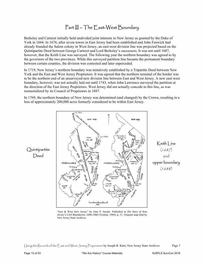
Part III – The East-West Boundary Berkeley and Carteret initially held undivided joint interests in New Jersey as granted by the Duke of York in 1664. In 1676, after seven towns in East Jersey had been established and John Fenwick had already founded the Salem colony in West Jersey, an east-west division line was projected based on the Quintipartite Deed between George Carteret and Lord Berkeley’s successors. It was not until 1687, however, that the Keith Line was surveyed. The following year the northern boundary was agreed to by the governors of the two provinces. While this surveyed partition line became the permanent boundary between certain counties, the division was contested and later superceded.
In 1719, New Jersey’s northern boundary was tentatively established by a Tripartite Deed between New York and the East and West Jersey Proprietors. It was agreed that the northern terminal of the border was to be the northern end of an unsurveyed new division line between East and West Jersey. A new east-west boundary, however, was not actually laid out until 1743, when John Lawrence surveyed the partition at the direction of the East Jersey Proprietors. West Jersey did not actually concede to this line, as was memorialized by its Council of Proprietors in 1887.
In 1769, the northern boundary of New Jersey was determined (and changed) by the Crown, resulting in a loss of approximately 200,000 acres formerly considered to be within East Jersey.
“East & West New Jersey” by John P. Snyder. Published in The Story of New Jersey’s Civil Boundaries, 1606-1968 (Trenton, 1969), p. 31. Original map held by New Jersey State Archives.
Quintipartite Deed
Keith Line (1687)
and upper boundary
(1688)
Page 13 of 53 "We Are History" Course Materials NJSPLS SurvCon 2016
Using the Records of the East and West Jersey Proprietors by Joseph R. Klett, New Jersey State Archives Page 8
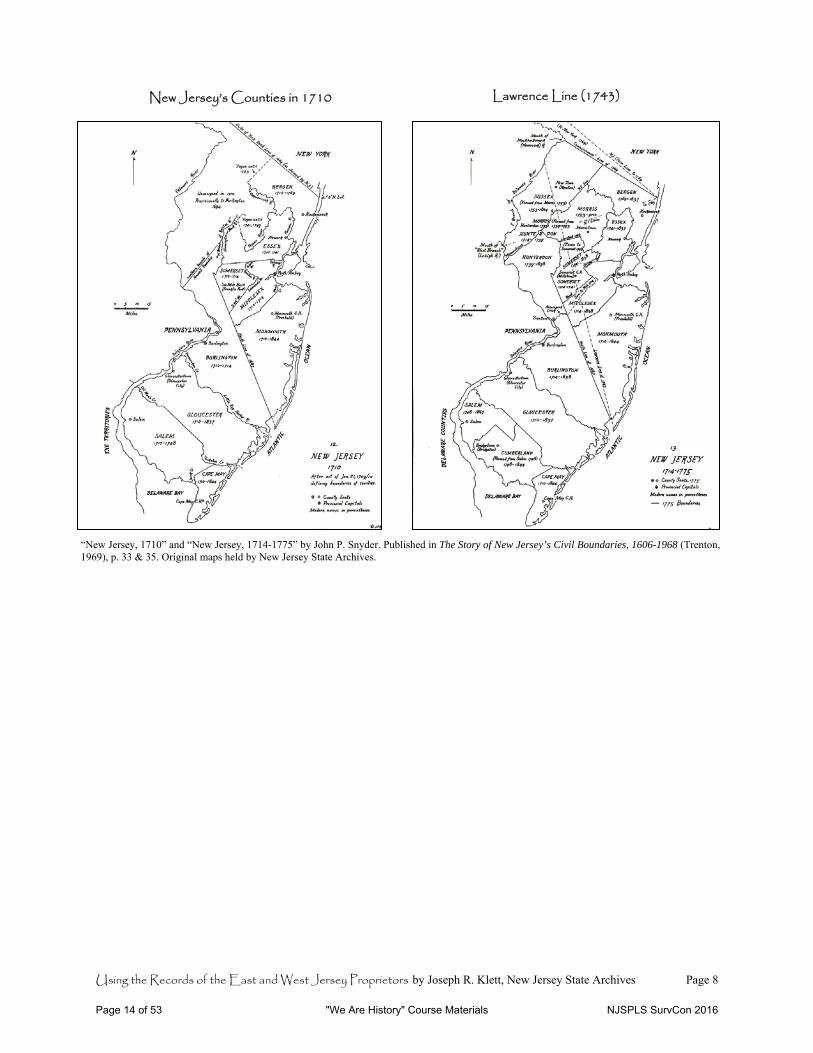
New Jersey’s Counties in 1710 Lawrence Line (1743)
“New Jersey, 1710” and “New Jersey, 1714-1775” by John P. Snyder. Published in The Story of New Jersey’s Civil Boundaries, 1606-1968 (Trenton, 1969), p. 33 & 35. Original maps held by New Jersey State Archives.
Page 14 of 53 "We Are History" Course Materials NJSPLS SurvCon 2016
Using the Records of the East and West Jersey Proprietors by Joseph R. Klett, New Jersey State Archives Page 9
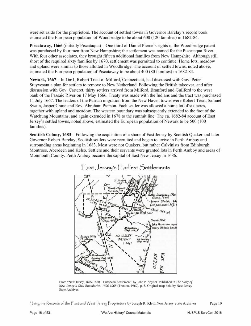
Part IV – East Jersey’s Earliest Settlements Adapted from John E. Pomfret, The New Jersey Proprietors and Their Lands, 1664-1776 (Princeton, 1964) and John P. Snyder, The Story of New Jersey’s Civil Boundaries, 1606-1968 (Trenton, 1969). See also Joseph R. Klett, “An Account of East Jersey’s Seven Settled Towns, circa 1684” in The Genealogical Magazine of New Jersey 80 (September 2005):106-14. This last source transcribes a town-by-town description of East Jersey prepared for Robert Barclay, who was appointed governor of the province in 1682. Bergen, 1661/1665 – Originally settled by the Dutch as part of the New Netherland colony and incorporated by Peter Stuyvesant in 1661. Settlements included Harsimus and Communipaw (parts of Jersey City), and Pemrepaugh (part of Bayonne). In November 1665, thirty-two residents took the oath of allegiance to the proprietors—the first settlers in New Jersey to do so. Chartered as Bergen Township under Governor Carteret on 22 September 1668. From 1667 to 1670, huge purchases were made in the Bergen area with the approbation of Carteret by speculators from Barbados, namely William Sandford, Nathaniel Kingsland and John Berry. The area was called “New Barbadoes”; certain grants were within the boundaries of Newark (see below). The account of East Jersey’s settled towns, ca. 1682-84, noted above, estimated the European population of Bergen to be about 350 (70 families) at that time.
Elizabeth-Town, 1664 – Patent granted by Gov. Nicolls on 1 December 1664 to John Baker, John Ogden, John Bayly and Luke Watson. Large tract between Raritan and Passaic rivers purchased from the Indians for £154. Includes all of present-day Union County and parts of Morris and Somerset, about 500,000 acres in all. Only four families had settled in this area at the time of Philip Carteret’s arrival in August 1665. The town plat was laid out and rights were offered at £4 apiece. Home lots were six acres; second- and third-lot rights were proportionately larger. Elizabeth-Town was initially the capital of New Jersey and later East Jersey until 1686. In February 1666, sixty-five lot owners took the oath of allegiance to King Charles and to the proprietors. Practically all were settlers from Long Island with Puritan New England origins. In May 1666, three principal owners, Carteret, Ogden and Watson, sold the southern half their patent to settlers from Massachusetts (see Woodbridge below). The account of settled towns, noted above, estimated the European population of Elizabeth-Town to be about 750 (150 families) in 1682-84.
Middletown & Shrewsbury, 1665 (a.k.a. Navesink or Monmouth Patent) – In April 1665, twelve men, principally from Long Island, obtained a triangular tract from Governor Nicolls extending from Sandy Hook to the mouth of the Raritan River, up the river approximately twenty-five miles, then southwest to Barnegat Bay. The area was first known as Navesink, then Middletown and Shrewsbury County, and finally in 1683 as Monmouth County. Founders were mostly Baptists and Quakers. Purchasers at Middletown and Shrewsbury subscribed £3 or £4, which entitled them to 120 acres with additional increments for wives and children, and 60 acres for each servant. As many as eighty families arrived from Long Island, Rhode Island and Massachusetts during the first years. Quaker meetings were established by 1670. Settlers understood their patent to have endowed them with a right of government. The account of settled towns, ca. 1682-84, noted above, estimated the European population of Middletown to be 500 (100 families) and Shrewsbury to be about 400 (80 families) at that time.
Woodbridge, 1666 – Founded by Daniel Pierce, John Pike and Abraham Tappan of Newbury, Massachusetts, who purchased the southern half of the Elizabeth-Town patent in 1666. Pierce sold a third of his holdings to four men from New Hampshire (see Piscataway below). They added other associates, who also received 240 acres of upland and 40 acres of meadow. Individual settlers purchased allotments from the associates. In February 1668, thirteen Woodbridge men took the oath of allegiance as required by the proprietors. A town charter was received from Gov. Carteret in June 1669. The charter stipulated that home lots were to be 10-20 acres; each purchaser would be entitled to 60 acres of upland and 6 acres of meadow. In lieu of the standard proprietor’s seventh, 1,000 acres at Ambo Point (later Perth Amboy)
Page 15 of 53 "We Are History" Course Materials NJSPLS SurvCon 2016
Using the Records of the East and West Jersey Proprietors by Joseph R. Klett, New Jersey State Archives Page 10
were set aside for the proprietors. The account of settled towns in Governor Barclay’s record book estimated the European population of Woodbridge to be about 600 (120 families) in 1682-84.
Piscataway, 1666 (initially Piscataqua) – One third of Daniel Pierce’s rights in the Woodbridge patent was purchased by four men from New Hampshire; the settlement was named for the Piscataqua River. With four other associates, they brought fifteen additional families from New Hampshire. Although still short of the required sixty families by 1670, settlement was permitted to continue. Home lots, meadow and upland were similar to those allotted in Woodbridge. The account of settled towns, noted above, estimated the European population of Piscataway to be about 400 (80 families) in 1682-84.
Newark, 1667 – In 1661, Robert Treat of Milford, Connecticut, had discussed with Gov. Peter Stuyvesant a plan for settlers to remove to New Netherland. Following the British takeover, and after discussion with Gov. Carteret, thirty settlers arrived from Milford, Branford and Guilford to the west bank of the Passaic River on 17 May 1666. Treaty was made with the Indians and the tract was purchased 11 July 1667. The leaders of the Puritan migration from the New Haven towns were Robert Treat, Samuel Swain, Jasper Crane and Rev. Abraham Pierson. Each settler was allowed a home lot of six acres, together with upland and meadow. The western boundary was subsequently extended to the foot of the Watchung Mountains, and again extended in 1678 to the summit line. The ca. 1682-84 account of East Jersey’s settled towns, noted above, estimated the European population of Newark to be 500 (100 families).
Scottish Colony, 1683 – Following the acquisition of a share of East Jersey by Scottish Quaker and later Governor Robert Barclay, Scottish settlers were recruited and began to arrive in Perth Amboy and surrounding areas beginning in 1683. Most were not Quakers, but rather Calvinists from Edinburgh, Montrose, Aberdeen and Kelso. Settlers and their servants were granted lots in Perth Amboy and areas of Monmouth County. Perth Amboy became the capital of East New Jersey in 1686.
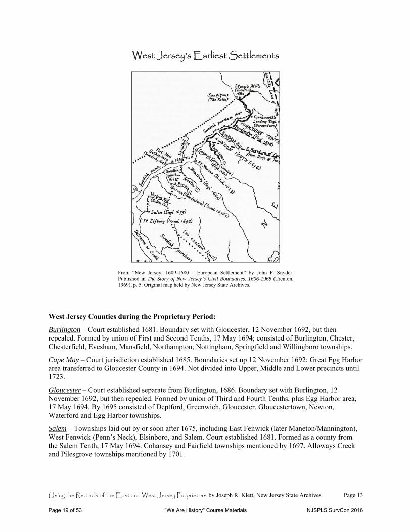
East Jersey’s Earliest Settlements
From “New Jersey, 1609-1680 – European Settlement” by John P. Snyder. Published in The Story of New Jersey’s Civil Boundaries, 1606-1968 (Trenton, 1969), p. 5. Original map held by New Jersey State Archives.
Page 16 of 53 "We Are History" Course Materials NJSPLS SurvCon 2016
Using the Records of the East and West Jersey Proprietors by Joseph R. Klett, New Jersey State Archives Page 11
East Jersey Counties during the Proprietary Period:
Bergen – Established 7 March 1683. In 1693, formally divided into Bergen and Hackensack Townships. New Barbadoes added from Essex County in 1710.
Essex – Established 7 March 1683. In 1693, formally divided into townships of New Barbadoes & Acquackanonk (a single township), Newark and Elizabeth-Town.
Middlesex – Established 7 March 1683. In 1693, formally divided into Woodbridge, Perth Amboy and Piscataway townships.
Monmouth – Established 7 March 1683. In 1693, formally divided into Freehold, Middletown and Shrewsbury townships.
Somerset – Set off from Middlesex County, 14 May 1688; administered as a single township in 1693, and not divided into precincts until about 1745.
Page 17 of 53 "We Are History" Course Materials NJSPLS SurvCon 2016
Using the Records of the East and West Jersey Proprietors by Joseph R. Klett, New Jersey State Archives Page 12
Part V – West Jersey’s Earliest Settlements Adapted from John E. Pomfret, The New Jersey Proprietors and Their Lands, 1664-1776 (Princeton, 1964) and John P. Snyder, The Story of New Jersey’s Civil Boundaries, 1606-1968 (Trenton, 1969). West Jersey was first developed as a Quaker colony, with initial settlement primarily coming directly from England. The proprietors’ one-hundredth shares in West Jersey were estimated to equate to roughly twenty thousand acres each. Tenth-part divisions of the colony were later superseded by counties. Indentured servants were few in West Jersey compared to East Jersey, and the quit-rent system—so problematic in East Jersey—was never prevalent in the western division. This was due to the greater competition for sales to settlers as a result of a greater fractioning of proprietary rights in West Jersey. The unit of settlement was a medium-sized farm from fifty to three hundred acres.
Salem, 1675 (or Salem Tenth, a.k.a. Fenwick’s Colony) – Founded in November 1675 by Quaker John Fenwick, who had held title to the Berkeley undivided half interest in New Jersey in trust for Edward Byllynge. Based on his financial contribution, he was granted one tenth of West Jersey. Land was offered at £5 per 100 acres; owners of 1,000 to 10,000 acres were to be proprietors or freeholders. Settlers were largely Quakers of modest means, generally merchants or craftsmen. See also Swedish Colonists below.
Yorkshire Tenth – Ten shares of West Jersey were conveyed to five Yorkshire men at the Falls of the Delaware (Trenton). This first tenth (northernmost to be surveyed) became known as the Yorkshire Tenth, and was settled by mostly Yorkshire families. Initially, both the Yorkshire group and the “south country” or London group (see below) remained together on Rancocas Creek, later Burlington City.
London Tenth (including Burlington) – The second tenth was purchased by “south country” Englishmen united under commissioners to establish settlement on the Rancocas. The ship Kent arrived at Burlington in August 1677 carrying 230 passengers from Hull, in Yorkshire, and London. The settlement was first called New Beverly. Town lots were drawn in October 1677; settlement began in December 1678. Each owner of a whole propriety was entitled to 10 acres within the town plus 64 acres of meadow. Burlington became the capital of West New Jersey in 1681.
Irish Tenth – Six of the Irish proprietors of West Jersey settled on the third tenth, consisting of the land between the Pennsauken and Timber creeks (present-day Camden County). Their agent Robert Zane, then living at Salem, scouted out the land prior to the settlers’ arrival in November 1681 and chose Newton Creek. The village of Newton was founded in 1682, after the settlers spent their first American winter in Fenwick’s Colony. Cooper’s Ferry had been established (at present-day Camden) in 1681. In 1685, Gloucestertown Township (now Gloucester City) became the first municipality formed within the Third and Fourth Tenths, which were united as Gloucester County in 1694. Newton, Waterford and Gloucester townships were established in 1695.
Fourth Tenth and Swedish Colonists – The land between Timber Creek and Oldmans Creek was called the Fourth Tenth, and became present-day Gloucester County. Areas within this tenth and along the southern Delaware River and Bay within the “Lower Six Tenths” had been part of the former colony of New Sweden. Fort Elfsborg below Salem Creek (called Varkens Kill) was an early Swedish settlement on the New Jersey side. New Sweden was taken over by the Dutch in 1655, and as part of New Netherland was taken over by the English in 1664. English settlement of the Fourth Tenth was well established by 1685, with Woodbury founded in 1683. The area called Raccoon, on the creek by that name, was settled by Swedish families in the 1670s. Regardless of earlier grants in the area as part of New Sweden and under the Dutch, new patents and titles were required by the English proprietorship. West Jersey’s third and fourth tenths became “old” Gloucester County in 1694. Egg Harbor Township (present-day Atlantic County) was established that year; Deptford and Greenwich were established in 1695.
Page 18 of 53 "We Are History" Course Materials NJSPLS SurvCon 2016
Using the Records of the East and West Jersey Proprietors by Joseph R. Klett, New Jersey State Archives Page 13
West Jersey’s Earliest Settlements
From “New Jersey, 1609-1680 – European Settlement” by John P. Snyder. Published in The Story of New Jersey’s Civil Boundaries, 1606-1968 (Trenton, 1969), p. 5. Original map held by New Jersey State Archives.
West Jersey Counties during the Proprietary Period:
Burlington – Court established 1681. Boundary set with Gloucester, 12 November 1692, but then repealed. Formed by union of First and Second Tenths, 17 May 1694; consisted of Burlington, Chester, Chesterfield, Evesham, Mansfield, Northampton, Nottingham, Springfield and Willingboro townships.
Cape May – Court jurisdiction established 1685. Boundaries set up 12 November 1692; Great Egg Harbor area transferred to Gloucester County in 1694. Not divided into Upper, Middle and Lower precincts until 1723.
Gloucester – Court established separate from Burlington, 1686. Boundary set with Burlington, 12 November 1692, but then repealed. Formed by union of Third and Fourth Tenths, plus Egg Harbor area, 17 May 1694. By 1695 consisted of Deptford, Greenwich, Gloucester, Gloucestertown, Newton, Waterford and Egg Harbor townships.
Salem – Townships laid out by or soon after 1675, including East Fenwick (later Maneton/Mannington), West Fenwick (Penn’s Neck), Elsinboro, and Salem. Court established 1681. Formed as a county from the Salem Tenth, 17 May 1694. Cohansey and Fairfield townships mentioned by 1697. Alloways Creek and Pilesgrove townships mentioned by 1701.
Page 19 of 53 "We Are History" Course Materials NJSPLS SurvCon 2016
Using the Records of the East and West Jersey Proprietors by Joseph R. Klett, New Jersey State Archives Page 14
Part VI – Key Terms and Document Types
Council/General Board of Proprietors – The governing bodies of the province and of its divisions’ voting shareholders. While both bodies were originally referred to in early records as councils, East Jersey’s governing body became the “General Board of Proprietors.” Officers include the President, Vice President(s), Treasurer, Registrar/Clerk, and Surveyor General. The secretarial functionary was titled Recorder, Registrar, Secretary and Clerk at various times during the early history of the proprietors, but became the Registrar in East Jersey and Clerk in West Jersey. East Jersey also had a Receiver General to collect quit-rents during colonial times.
In the proprietary and colonial periods, the authority of the various offices can be unclear because the proprietors in England, the colonial legislative assemblies, the West Jersey Society and the colonial governors held and exercised varying rights over appointments, quit-rent collection, etc. Further, the government office of provincial secretary (after 1702) and the proprietary office of recorder or registrar were sometimes vested in the same person.
Minutes – The ongoing record of decisions made by the governing body. The minutes of East Jersey’s proprietors in America were published by the General Board for the period 1685-1794 (in 4 vols.), and can be read in manuscript form after that date to the dissolution of the General Board in 1998. The 1682-84 minutes of East Jersey’s proprietors in England were discovered in Governor Barclay’s record book, acquired at auction by the State Archives in 2005. A full transcription was published in 2009 (see Bibliography forward, under Klett).
West Jersey’s minutes begin in 1688, and are available on microfilm through 1951. They have never been published, though are now (2014) partly transcribed in anticipation of publication.
Share/Propriety – A right to a fractional division of the proprietorship of the colony, and the basis for voting rights in the General Board or Council. Sometimes, but not exclusively, used to mean a full share (i.e., 1/100th in West Jersey).
East Jersey – The rights to unappropriated land in the eastern division were held by the original Twenty-Four Proprietors in 1682; however, patents for six settlements had already been granted prior to that time and many town lots and tracts in those areas had already been sold. The twenty-four shares were subsequently divided into quarter parts, resulting in ninety-six total shares of East Jersey. One full quarter share entitled a shareholder to vote as a proprietor on East Jersey’s General Board.
West Jersey – The western division was partitioned into tenths, with one tenth granted to John Fenwick. “Fenwick’s Colony” became present-day Salem and Cumberland counties, and was essentially independent of the remaining trustees of West Jersey. The other nine tenths of West Jersey were then divided again into tenths producing ninety hundredth parts. These shares, or proprieties, were then divided into smaller parts. Some shares were divided into sevenths (i.e., 1/7 of 1/90) and initially valued at £50—an affordable price for many investors. Many of the shares were divided into 1/32 parts, and this became the minimum holding required for a shareholder to be entitled to a proprietary voting right.
As a result of the smaller fractioning of shares, the number of shareholders in West Jersey was (is) potentially much greater—hypothetically a maximum of 3,200 votes. However, shares were and always have been consolidated, so the number of voting proprietors was never so high. Also, due to incomplete recordkeeping during the early period a number of shares of West Jersey have never been accounted for since soon after the colony was established.
Page 20 of 53 "We Are History" Course Materials NJSPLS SurvCon 2016
Using the Records of the East and West Jersey Proprietors by Joseph R. Klett, New Jersey State Archives Page 15
Shareholder/Proprietor – The owner of a share or shares of the province. “Proprietor” is typically used to mean a member of the General Board or Council, i.e., a voting shareholder. Owners of smaller fractions of shares are not considered “proprietors” since they do not have voting rights.
Order – A directive from the Board or Council to perform an action (e.g., to issue land rights after a dividend has been declared or to accept a claim or survey). Orders are recorded in the minutes.
Dividend – The share allotted to each of several persons entitled to part of a division of profits or property. Proprietary dividends have generally taken the form of a proportional share of a total number of acres of previously unappropriated land. Each shareholder receives an allotment of acreage in a location of his choosing, according to the proportion of shares held. In East Jersey (as of 1993), twelve dividends of “good land rights” had been granted. In each of the first two divisions, dividends were 10,000 acres to a quarter share. West Jersey’s initial dividend was 5,200 acres per full share, but only 3,200 acres were distributed; a second “taking” of 2,000 acres per share occurred in 1683.
Patent – A grant of a privilege, property, right, franchise or authority made to one or more individuals by the government or sovereign entity. In proprietary New Jersey, typically a patent (a.k.a. grant) came from the crown or governor to the proprietors or a group of settlers, or from the proprietors to the first purchasers of previously unappropriated land.
Warrant – An authority issued by the Registrar/Clerk to the Surveyor to lay out a parcel of land in compensation for a claim or right (of a shareholder), or a part thereof. Depending upon the time period, warrants in East and West Jersey may be recorded in the same books as the surveys, or in separate volumes.
Survey and Return – After a warrant is issued, a survey is (or multiple surveys are) made in which the boundaries of the parcel(s) are laid out. To document the fulfillment of the warrant, the Surveyor General signs a “return,” which once accepted by the proprietors is recorded as is the survey itself. The return is essentially an application to the Board/Council for severance of title, and once it is accepted and recorded it becomes part of the chain of title. The land is then either considered to be or can be formally conveyed to the shareholder. (Practice varies between East and West Jersey as to whether a separate conveyance instrument would have been created, and depends on the time period.) The surveys were recorded into books in both East and West Jersey, and both also have original loose returns beginning at different dates. Loose surveys typically include a drawing of the metes and bounds of the property in addition to the narrative record, and are therefore especially interesting when researching property ownership. East Jersey’s loose surveys begin in 1786, and are available on microfilm and original form. West Jersey’s loose surveys, on deposit at the State Archives, begin in the 1680s. The State Archives is currently processing these documents, which are not fully accessible to the public at this time.
A caveat is produced when another landowner asserts that a new survey overlaps with land that has been previously appropriated. If the Surveyor General finds that the caveat is valid after a resurvey, a certificate of mislocation is issued to document that all or part of the tract surveyed was previously appropriated and to credit the deficient acreage to the account of the individual with the inferior (later) title.
Deed/Conveyance/Indenture – A writing signed by the grantor whereby title to realty is transferred from one to another. Note that the grantee does not sign the deed. The earliest books recording deeds, surveys and government commissions (see below) in East and West Jersey were united in the office of the Secretary of State over two hundred years ago. Prior to the establishment of the state government in 1776—and subsequently the establishment of Trenton as the state capital in 1790—these volumes were located in the former dual capitals of Perth Amboy and Burlington. The recording function at the colonial level was vested in the Provincial Secretary, predecessor of the Secretary of State, who was responsible for the books and had deputies for an in each of the two divisions of the colony.
Page 21 of 53 "We Are History" Course Materials NJSPLS SurvCon 2016
Using the Records of the East and West Jersey Proprietors by Joseph R. Klett, New Jersey State Archives Page 16
As the provincial secretaries/deputies were sometimes also the registrars or recorders of the East and West Jersey proprietors, the colonial provenance of the volumes is murky. In 1743, amidst the brewing controversy over land rights in Elizabeth-Town, the East Jersey Proprietors asserted ownership of the record books for the eastern division. They argued that the volumes had been “quietly” possessed by the proprietors after 1702 and that actions during Gov. Edward Hyde, Lord Cornbury’s administration which resulted in the government taking over recordkeeping were arbitrary and in conflict with the laws of the time.
This argument appears to have proved fruitless—at least in terms of the proprietors retaining or recovering the original books. Instead, the East Jersey Proprietors at its own expense produced a set of exemplified copies of the East Jersey volumes. This had been authorized by the East Jersey board in 1741, and the copies continue through Book E-2, which ends in that year. The controversy aside, separate books were still kept for (and assumedly in) East and West Jersey respectively through 1776.
Commission – A certificate issued from the government to a person authorizing and empowering him/her to perform certain duties such as the responsibilities of an office or military rank, executing judicial jurisdiction, etc. Commissions were recorded in the same colonial record books as deeds and surveys. Presumably, the colonial government claimed these early books as records of the Provincial Secretary based on the fact that they contained such documentation of governance.
Quit-Rent – A rent paid by the tenant of a freehold (i.e., on purchased property) to the grantor by which the tenant goes “quit and free,” that is, discharged from any other rent. In proprietary New Jersey, this was at first one half-penny per acre annually, or in some cases one penny per acre for town lands. East Jersey quit-rents were later 6 pence per 100 acres. While quit-rents were required throughout East Jersey, they were never systematically or effectively collected. It is estimated that in 1696, quit-rents were paid by only about 40-50% of the landowners required to pay, yielding only £200 for all of East Jersey. Separate records relating to the collection of quit-rents exist for East Jersey for the 1667-1703 period, but the completeness and usefulness of these accountings is uncertain.
The quit-rent system was not prevalent in West Jersey. (Only certain proprietors, including Dr. Daniel Coxe, demanded quit-rents.) Competition for land sales resulted in this title encumbrance not being required by most West Jersey shareholders in their deeds. Hence, we find no separate quit-rent records for West Jersey.
Road Return – The record of a survey made for a public road, typically mentioning property owners and/or buildings or other landmarks along the right-of-way. A road book for the period ca. 1740-1902 is among the records of the East Jersey Proprietors.
Maps – Both East and West Jersey proprietors have produced collections of maps. However, they tend to be for large areas (including “sweep surveys” to determine the location of unappropriated land). Since settling landowners are not typically shown, the maps are of limited value for genealogical research.
East and West Jersey Proprietors’ maps are available in original form at the State Archives. Note that depending upon their physical condition, some maps may be closed until they can be repaired and imaged.
Page 22 of 53 "We Are History" Course Materials NJSPLS SurvCon 2016
Using the Records of the East and West Jersey Proprietors by Joseph R. Klett, New Jersey State Archives Page 17
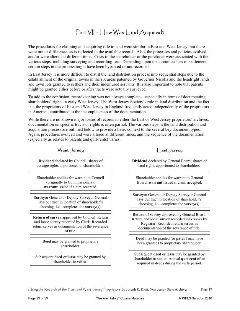
Part VII – How Was Land Acquired? The procedures for claiming and acquiring title to land were similar in East and West Jersey, but there were minor differences as is reflected in the available records. Also, the processes and policies evolved and/or were altered at different times. Costs to the shareholder or the purchaser were associated with the various steps, including surveying and recording fees. Depending upon the circumstances of settlement, certain steps in the process might have been bypassed or not recorded.
In East Jersey it is more difficult to distill the land distribution process into sequential steps due to the establishment of the original towns in the six areas patented by Governor Nicolls and the headright lands and town lots granted to settlers and their indentured servants. It is also important to note that patents might be granted either before or after tracts were actually surveyed.
To add to the confusion, recordkeeping was not always complete—especially in terms of documenting shareholders’ rights in early West Jersey. The West Jersey Society’s role in land distribution and the fact that the proprietors of East and West Jersey in England frequently acted independently of the proprietors in America, contributed to the incompleteness of the documentation.
While there are no known major losses of records in either the East or West Jersey proprietors’ archives, documentation on specific tracts or rights is often partial. The various steps in the land distribution and acquisition process are outlined below to provide a basic context to the several key document types. Again, procedures evolved and were altered at different times, and the sequence of the documentation (especially as relates to patents and quit-rents) varies. West Jersey East Jersey
Dividend declared by Council; shares of acreage rights apportioned to shareholders.
Shareholder applies for warrant to Council (originally to Commissioners);
warrant issued if claim accepted.
Surveyor General or Deputy Surveyor General lays out tract in location of shareholder’s choosing, i.e., completes the survey(s).
Return of survey approved by Council. Return and loose survey recorded by Clerk. Recorded
return serves as documentation of the severance of title.
Deed may be granted to proprietary shareholder.
Dividend declared by General Board; shares of land rights apportioned to shareholders.
Shareholder applies for warrant to General Board; warrant issued if claim accepted.
Surveyor General or Deputy Surveyor General lays out tract in location of shareholder’s choosing, i.e., completes the survey(s).
Return of survey approved by General Board. Return and loose survey recorded into books by
Registrar. Recorded return serves as documentation of the severance of title.
Deed may be granted (or patent may have been granted) to proprietary shareholder.
Subsequent deed or lease may be granted by shareholder to settler. Annual quit-rent often
required in deeds during the early period. Subsequent deed or lease may be granted by
shareholder to settler.
Page 23 of 53 "We Are History" Course Materials NJSPLS SurvCon 2016
Using the Records of the East and West Jersey Proprietors by Joseph R. Klett, New Jersey State Archives Page 18
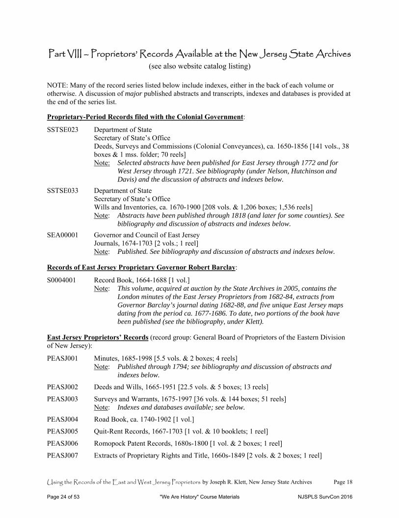
Part VIII – Proprietors’ Records Available at the New Jersey State Archives (see also website catalog listing)
NOTE: Many of the record series listed below include indexes, either in the back of each volume or otherwise. A discussion of major published abstracts and transcripts, indexes and databases is provided at the end of the series list. Proprietary-Period Records filed with the Colonial Government:
SSTSE023 Department of State Secretary of State’s Office Deeds, Surveys and Commissions (Colonial Conveyances), ca. 1650-1856 [141 vols., 38
boxes & 1 mss. folder; 70 reels] Note: Selected abstracts have been published for East Jersey through 1772 and for
West Jersey through 1721. See bibliography (under Nelson, Hutchinson and Davis) and the discussion of abstracts and indexes below.
SSTSE033 Department of State Secretary of State’s Office Wills and Inventories, ca. 1670-1900 [208 vols. & 1,206 boxes; 1,536 reels] Note: Abstracts have been published through 1818 (and later for some counties). See
bibliography and discussion of abstracts and indexes below.
SEA00001 Governor and Council of East Jersey Journals, 1674-1703 [2 vols.; 1 reel] Note: Published. See bibliography and discussion of abstracts and indexes below.
Records of East Jersey Proprietary Governor Robert Barclay:
S0004001 Record Book, 1664-1688 [1 vol.] Note: This volume, acquired at auction by the State Archives in 2005, contains the
London minutes of the East Jersey Proprietors from 1682-84, extracts from Governor Barclay’s journal dating 1682-88, and five unique East Jersey maps dating from the period ca. 1677-1686. To date, two portions of the book have been published (see the bibliography, under Klett).
East Jersey Proprietors’ Records (record group: General Board of Proprietors of the Eastern Division of New Jersey):
PEASJ001 Minutes, 1685-1998 [5.5 vols. & 2 boxes; 4 reels] Note: Published through 1794; see bibliography and discussion of abstracts and
indexes below.
PEASJ002 Deeds and Wills, 1665-1951 [22.5 vols. & 5 boxes; 13 reels]
PEASJ003 Surveys and Warrants, 1675-1997 [36 vols. & 144 boxes; 51 reels] Note: Indexes and databases available; see below.
PEASJ004 Road Book, ca. 1740-1902 [1 vol.]
PEASJ005 Quit-Rent Records, 1667-1703 [1 vol. & 10 booklets; 1 reel]
PEASJ006 Romopock Patent Records, 1680s-1800 [1 vol. & 2 boxes; 1 reel]
PEASJ007 Extracts of Proprietary Rights and Title, 1660s-1849 [2 vols. & 2 boxes; 1 reel]
Page 24 of 53 "We Are History" Course Materials NJSPLS SurvCon 2016
Using the Records of the East and West Jersey Proprietors by Joseph R. Klett, New Jersey State Archives Page 19
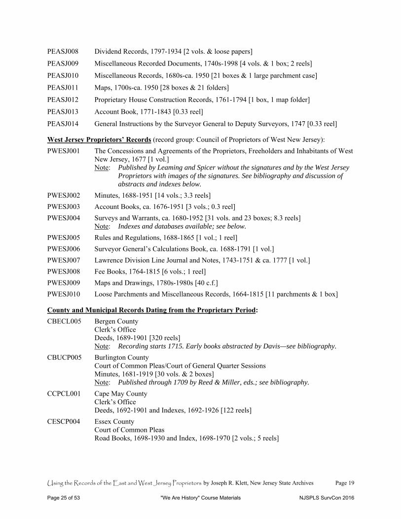
PEASJ008 Dividend Records, 1797-1934 [2 vols. & loose papers]
PEASJ009 Miscellaneous Recorded Documents, 1740s-1998 [4 vols. & 1 box; 2 reels]
PEASJ010 Miscellaneous Records, 1680s-ca. 1950 [21 boxes & 1 large parchment case]
PEASJ011 Maps, 1700s-ca. 1950 [28 boxes & 21 folders]
PEASJ012 Proprietary House Construction Records, 1761-1794 [1 box, 1 map folder]
PEASJ013 Account Book, 1771-1843 [0.33 reel]
PEASJ014 General Instructions by the Surveyor General to Deputy Surveyors, 1747 [0.33 reel]
West Jersey Proprietors’ Records (record group: Council of Proprietors of West New Jersey):
PWESJ001 The Concessions and Agreements of the Proprietors, Freeholders and Inhabitants of West New Jersey, 1677 [1 vol.]
Note: Published by Leaming and Spicer without the signatures and by the West Jersey Proprietors with images of the signatures. See bibliography and discussion of abstracts and indexes below.
PWESJ002 Minutes, 1688-1951 [14 vols.; 3.3 reels]
PWESJ003 Account Books, ca. 1676-1951 [3 vols.; 0.3 reel]
PWESJ004 Surveys and Warrants, ca. 1680-1952 [31 vols. and 23 boxes; 8.3 reels] Note: Indexes and databases available; see below.
PWESJ005 Rules and Regulations, 1688-1865 [1 vol.; 1 reel]
PWESJ006 Surveyor General’s Calculations Book, ca. 1688-1791 [1 vol.]
PWESJ007 Lawrence Division Line Journal and Notes, 1743-1751 & ca. 1777 [1 vol.]
PWESJ008 Fee Books, 1764-1815 [6 vols.; 1 reel]
PWESJ009 Maps and Drawings, 1780s-1980s [40 c.f.]
PWESJ010 Loose Parchments and Miscellaneous Records, 1664-1815 [11 parchments & 1 box]
County and Municipal Records Dating from the Proprietary Period:
CBECL005 Bergen County Clerk’s Office Deeds, 1689-1901 [320 reels] Note: Recording starts 1715. Early books abstracted by Davis—see bibliography.
CBUCP005 Burlington County Court of Common Pleas/Court of General Quarter Sessions Minutes, 1681-1919 [30 vols. & 2 boxes] Note: Published through 1709 by Reed & Miller, eds.; see bibliography.
CCPCL001 Cape May County Clerk’s Office Deeds, 1692-1901 and Indexes, 1692-1926 [122 reels]
CESCP004 Essex County Court of Common Pleas Road Books, 1698-1930 and Index, 1698-1970 [2 vols.; 5 reels]
Page 25 of 53 "We Are History" Course Materials NJSPLS SurvCon 2016
Using the Records of the East and West Jersey Proprietors by Joseph R. Klett, New Jersey State Archives Page 20
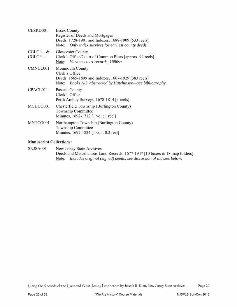
CESRD001 Essex County Register of Deeds and Mortgages Deeds, 1728-1901 and Indexes, 1688-1909 [533 reels] Note: Only index survives for earliest county deeds.
CGLCL... & Gloucester County CGLCP... Clerk’s Office/Court of Common Pleas [approx. 94 reels] Note: Various court records, 1680s+.
CMNCL001 Monmouth County Clerk’s Office Deeds, 1665-1899 and Indexes, 1667-1929 [383 reels] Note: Books A-D abstracted by Hutchinson—see bibliography.
CPACL011 Passaic County Clerk’s Office Perth Amboy Surveys, 1678-1814 [3 reels]
MCHCO001 Chesterfield Township (Burlington County) Township Committee Minutes, 1692-1712 [1 vol.; 1 reel]
MNTCO001 Northampton Township (Burlington County) Township Committee Minutes, 1697-1824 [1 vol.; 0.2 reel]
Manuscript Collections:
SNJSA001 New Jersey State Archives Deeds and Miscellanous Land Records, 1677-1947 [10 boxes & 18 map folders] Note: Includes original (signed) deeds; see discussion of indexes below.
Page 26 of 53 "We Are History" Course Materials NJSPLS SurvCon 2016
Using the Records of the East and West Jersey Proprietors by Joseph R. Klett, New Jersey State Archives Page 21
Major Published Abstracts and Transcripts, Indexes and Databases – An Annotated List
East and West Jersey: Leaming, Aaron and Spicer, Jacob eds. The Grants, Concessions, and Original Constitutions of the Province of New Jersey. The Acts Passed during the Proprietary Governments, and other Material Transactions before the Surrender Thereof to Queen Anne. (Philadelphia, Pa.: [1758]). See also reprint: The Grants, Concessions, and original Constitutions … (Union, N.J.: 2002). This includes various charters, laws and key documents relating to the proprietary and colonial periods, including Berkeley’s and Carteret’s charter and as well as West Jersey’s concessions and agreements of 1676. Leaming and Spicer do not include the names of those who signed the West Jersey document. See below under West Jersey for further information about that document specifically.
Hartlaub, Robert J. and George J. Miller. “Index to Colonial Conveyances, East & West Jersey, 1664-1794.” This unpublished, two-volume set indexes the grantees and grantors in deeds and surveys contained in the East and West Jersey books filed with the Secretary of State. The volumes—copies of which were placed in a small number of New Jersey repositories—supersede an earlier card index. The following information is provided: grantee and grantor (in one alphabetical sequence, showing whether “to” or “from”), book and page reference, date, and location or other explanatory notes. Approximately 112 volumes are indexed, thirty-one of which are abstracted or partially abstracted in Nelson’s Patents and Deeds ... (see below).
“Proprietary Warrants and Surveys, 1670-1727.” This database is available online at the State Archives website <https://wwwnet1.state.nj.us/DOS/Admin/ArchivesDBPortal/NJProprietors.aspx>. It typically includes the following information for each record: name of grantee (i.e., to whom the survey was made), book and folio reference, location, date, acreage, explanatory notes. Sometimes additional patent and survey references (i.e., from other books or extracts) are included.
As of June 2014, this database indexes the following books:
East Jersey Liber II [2] of Surveys (“Carteret’s Conveyances”), 1670-1727. Liber numbers 1, 2 of Deeds, 3, 4, etc., were turned over to the provincial government and became part of the Secretary of State’s collection of colonial deeds and surveys (and therefore were indexed in the Hartlaub-Miller “Index to Colonial Conveyances ...” noted above and abstracted in Nelson’s Patents and Deeds … noted below). Liber II [2] of Surveys, however, was retained by the proprietors along with the other survey books, and therefore was not readily accessible to the public until 1998. Thus, providing access to its contents online was a priority for the State Archives. The book has two separately paginated parts and contains surveys and patents largely from the proprietary period (i.e., pre-1702).
East Jersey Books L and O of Surveys, 1670-1716. Book L includes surveys dating from the 1675-1688 period. Book O includes surveys from 1670-1716. Since these survey books from the proprietary period were retained by the East Jersey Proprietors, they were not abstracted in Nelson’s Patents and Deeds … noted below, or referenced in the Hartlaub-Miller “Index to Colonial Conveyances …” noted above. Their contents were not readily accessible to the public prior to 1998, and thus the State Archives made online access to these books a priority. References to Books L and O are found in the Elizabeth-Town Bill in Chancery (see below under East Jersey).
Basse’s Book of Surveys, 1677-1755. This West Jersey survey book, dating from the proprietary period, is part of the Secretary of State’s collection of colonial deeds and surveys. It is included in
Page 27 of 53 "We Are History" Course Materials NJSPLS SurvCon 2016

Using the Records of the East and West Jersey Proprietors by Joseph R. Klett, New Jersey State Archives Page 22
the Hartlaub-Miller “Index to Colonial Conveyances …” referenced above, but was not abstracted in Nelson’s Patents and Deeds … referenced below. It is also not included in the West Jersey Proprietors’ Index to Survey Books, 1681-1952 (see below under West Jersey). Therefore, the State Archives made it a priority to provide online access to this book.
Nelson, William, ed. Patents and Deeds and Other Early Records of New Jersey, 1664-1703. (Baltimore, Md.: Genealogical Publishing Co., Inc., 1976 etc.). Originally published as: Calendar of Records in the Office of the Secretary of State, 1664-1703 [Documents relating to the Colonial History of the State of New Jersey a.k.a. New Jersey Archives, First Series, Volume XXI]. (Paterson, N.J.: 1899). This volume contains abstracts from the bulk of seventeenth-century survey books included in the Secretary of State’s Deeds, Surveys and Commissions: ten from East Jersey and twenty-one from West Jersey. However, Liber 2 of Deeds (which is bound together with Liber 1) was not abstracted and also was apparently confused with Liber 2 of Surveys (which had been retained by the East Jersey Proprietors). Note that the index at the back of Nelson’s Patents and Deeds provides access to the names of bordering property owners in addition to the grantors and grantees. Also note that multi-page subsections indexing “Occupations” and “Places, Names of” are inserted into the general index under “O” and “P” respectively, making the use of the index tricky.
Whitehead, William A. et al., eds. Documents relating to the Colonial History of the State of New Jersey a.k.a. New Jersey Archives, First Series, Volume I, 1631-1687 and Volume II, 1687-1703. (Newark, N.J.: 1880-81). These two volumes contain transcriptions of the earliest documents relating to the founding of New Jersey and its first settlements. Each contains its own index, but both are also indexed by: Ricord, Frederick W. General Index to the Documents relating to the Colonial History of the State of New Jersey, First Series, in Ten Volumes. (Newark, 1888).
Nelson, William, ed. Calendar of New Jersey Wills, Vol. I, 1670-1730 [Documents relating to the Colonial History of the State of New Jersey a.k.a. New Jersey Archives, First Series, Volume XXI]. (Paterson, N.J.: 1899). The volume contains abstracts of the earliest estate records from East and West Jersey, and an every-name index. Various reprints have appeared in recent decades.
New Jersey Index of Wills, Volumes 1-3. (Originally published in 1912; reprinted by GPC, Baltimore, Md.: 1969 etc.). This three-volume set indexes estate records from the 1670s to the year 1900, providing the file and/or book and page reference to the original wills (all held by the State Archives). The index is arranged county by county. Note that the “Unrecorded Wills” and “Addenda” sections at the end of the third volume include many seventeenth-century estates. A statewide index produced by Accelerated Indexing Systems is also available; however, the original county-by-county index may easier to use in terms of finding the documents indexed.
Commissions Card Index, 1660s-1856. This index is found in the State Archives’ Manuscript Reading Room, and provides access to governmental commissions (to public office and military posts) recorded in the colonial deed and survey books.
Guide to New Jersey State Archives / Deeds and Miscellaneous Land Records, 1669-1947. This is an item-level inventory of original deeds and other land records acquired by the State Archives and its predecessors through donation, purchase or otherwise. Typically, these documents include an actual (as opposed to recorded) signature or mark of the grantor. The item descriptions are arranged by surname or corporate name and typically include the following information: name of grantor and grantee, date, location, and book and page reference to where the deed is recorded. Note that the collection includes many transactions not recorded in the deed books. East Jersey: Ricord, Frederick W. & William Nelson, eds. Journal of the Governor and Council, Vol. I, 1682-1714 [Documents relating to the Colonial History of the State of New Jersey a.k.a. New Jersey Archives,
Page 28 of 53 "We Are History" Course Materials NJSPLS SurvCon 2016
Using the Records of the East and West Jersey Proprietors by Joseph R. Klett, New Jersey State Archives Page 23
First Series, Volume XIII]. (Trenton, N.J., 1890). This is a record of the proceedings of the proprietary executive and his legislative council. The volume includes its own index.
Board of Proprietors of the Eastern Division of New Jersey. The Minutes of the Board of Proprietors of the Eastern Division of New Jersey, 1685-1794. 4 vols. (Perth Amboy, N.J.: 1949-85). This four-volume set contains transcribed minutes of the East Jersey Board for the first 110 years of its existence. Each volume contains its own index.
“Alphabetical Index to Surveys in the Office of the General Board of Proprietors of the Eastern Division of the State of New Jersey,” 1719-20th c. This is a master index all of the surveys recorded in the books retained and/or produced by the East Jersey Proprietors since the eighteenth century with the exception of the three volumes discussed above (under East and West Jersey)—Liber II (“Carteret’s Conveyances”), Book L and Book O. Finding the recorded surveys listed is a two-step process: the index is arranged alphabetically by the name of the person to whom the survey was made; it provides page and line references to a three-volume set of Extracts of Surveys. The extract books (numbered 1, 2 and 3, but also called Black, Red and Blue) provide the following information for each survey listed: shareholder’s name, survey book and page reference, county and acreage, and explanatory notes (a short description of land and/or cross references to related surveys). Extract Book No. 1 (“Black”) covers survey books S1 through S12, dating from 1719-1801. No. 2 (“Red”) covers survey books S12 through S21, dating from 1800-1835. No. 3 (“Blue”) covers survey books S22 and S23, dating from 1836 to the late twentieth century. Extract Books No. 2 & 3 also include reference to the name of the person at whose request the survey was made, that person being the first owner after severance of title from the Board. The master index uses the designations “No 2 R” for references to Extract Book No. 2 (Red) and “No 3 B” for references to Extract Book No. 3 (Blue); references without such a designation are to Extract No. 1 (Black). The page number is given before the “/” and the line number(s) after it. Information from this index and the related extract books will eventually be entered into the “Proprietary Warrants and Surveys” database noted above.
Database index of loose surveys, 1786-1951. This database was produced after the East Jersey loose surveys were processed (flattened and foldered) in 2002. Loose surveys were not retained by the Proprietors before 1786, and the first years are incomplete. Users of this database, therefore, must remember that it is not a comprehensive index of East Jersey’s surveys but rather a supplemental resource. Nevertheless, since the loose surveys typically include a drawing of the metes and bounds of the property surveyed, they are especially helpful when researching the history of a tract’s ownership. The database includes the following information: name(s) of persons to whom survey was made, survey book and page reference (i.e., where recorded), acreage, location and date. An alphabetical printout is available in the State Archives’ Manuscript Reading Room.
Elizabeth-Town Bill in Chancery and Answer, 1745 & 1751. The bill and answer include tables and maps relating to proprietary rights in Elizabeth-Town and the disputed distribution of land in the Clinker Lot Division. A photocopy of the bill (dated 1745 and printed in 1747) is available in the State Archives’ reference book collection. A copy of the published 1751 answer is owned by New Jersey Historical Society in Newark. The signed original is held by the New York Genealogical and Biographical Society, which published a good synopsis of the case and the list of signatories in 2007 (see bibliography under Goodwin). A list of the signatories to the answer can be found online at www.westfieldnjhistory.com.
Edsall, Preston W., ed. Journal of the Courts of Common Right and Chancery of East New Jersey, 1683-1702. (Philadelphia, Pa.: 1937). This publication provides a history of the court and a record of its proceedings. Prior to the surrender of governance to Queen Anne in 1702 and the establishment of the royal courts, the Court of Chancery had jurisdiction over matters of equity (fairness), including property disputes. A table of cases and an index are included at the end of the volume.
Page 29 of 53 "We Are History" Course Materials NJSPLS SurvCon 2016
Using the Records of the East and West Jersey Proprietors by Joseph R. Klett, New Jersey State Archives Page 24
Hutchinson, Richard S. East New Jersey Land Records. 9 vols. (Lewes, Del.: 2005-8). Hutchinson has abstracted the East Jersey volumes of the Secretary of State’s Deeds, Surveys and Commissions, continuing from Nelson, referenced above. The nine publications are broken down as follows:
H, I, K-small 1702-1717 (published 2008) A-2, B-2 1715-1722 (published 2007) C-2, D-2 1719-1727 (published 2007) E-2, F-2 1737-1747 (published 2006) G-2, H-2 1747-1757 (published 2007) I-2, K-2 1757-1763 (published 2005) A-3, B-3 1763-1766 (published 2006) K, C-3 1727-1737 (published 2007) D-3, E-3, F-3 1766-1772 (published 2008) West Jersey: The Concessions and Agreements of the Proprietors, Freeholders and Inhabitants of the Province of West New Jersey in America (Burlington, N.J.: 1951; revised 1977; possibly other revisions). The West Jersey Proprietors’ pamphlet versions of the 1676 concessions and agreements, as compared to the version in Leaming & Spicer above, includes the names of those who signed the document as “Proprietors, Freeholders and inhabitants the Province.”
Note that there is a recorded copy of the Concessions in the deeds, survey and commission books formerly held by the Secretary of State. It includes over 120 transcribed signatures, but not all of the names included in the original, which apparently continued to be used to attest allegiance to the charter. The recorded (State) copy is included in both the film reels of the Secretary of State’s books and the West Jersey Proprietors’ records. The original Concessions book, containing the original signatures of the shareholders and inhabitants, is now on deposit at the State Archives.
Index to Survey Books, 1681-1952. This volume, available on film and as a photocopy in the State Archives’ Microfilm and Manuscript Reading Rooms, serves as a master grantee index to thirty volumes of West Jersey Proprietors survey books. The index is arranged by the first letter of the surname, but within each letter the survey books are indexed sequentially. Therefore, each letter of the alphabet typically has thirty subsections. The heading for each subsection notes the name and inclusive dates of the survey book. Use the page reference from this index to go directly to the recorded survey, or first consult the extract volume discussed below to see a fuller description of the tract.
Extract of Survey Books, 1681-1952. This volume provides short descriptions of the surveys arranged by survey book and page. In addition to the thirty volumes covered by the Index to Survey Books discussed above, it also includes an extract of Basse’s Book of Surveys (1681-1755), which was held by the State from an early date and therefore not included in the West Jersey Proprietors’ “Index to Survey Books” referenced above. (Basse’s Book is, however, included in the Hartlaub-Miller “Index to Colonial Conveyances …”) The extract entries, listed book by book, include the following information: page number, name, acreage, county and township (if recorded), date, and “adjoining surveys and descriptive objects.”
Davis, John David. West Jersey, New Jersey, Deed Records, 1676-1721. (Westminster, Md.: 2005). John Davis has abstracted four West Jersey books from the Secretary of State’s Deeds and Surveys. These include volumes B (1676-1698), A-A-A (1680-1719), B-B (1713-1721) and B-B-B (1713-1721). Note that volume B was previously abstracted—though not as fully—in Nelson’s Patents and Deeds, referenced above.
Page 30 of 53 "We Are History" Course Materials NJSPLS SurvCon 2016
Using the Records of the East and West Jersey Proprietors by Joseph R. Klett, New Jersey State Archives Page 25
Checklist of Key Indexes to Surveys and Deeds
See the annotated list above for detailed information about each of the sources listed below.
EAST AND WEST JERSEY Incl. Dates Name of Source Archives Location(s) 1650-1801 “New Jersey's Early Land Records, 1650-1801” database at:
https://wwwnet1.state.nj.us/DOS/Admin/ArchivesDBPortal/NJProprietors.aspx www.archives.nj.gov(Searchable Databases site)
1664-1794 Hartlaub & Miller. “Index to Colonial Conveyances, East & West Jersey.” Indexes grantors and grantees only.
Microfilm Reading Room (reference books):
974.9 N5.23
1664-1703 Nelson. Patents and Deeds and Other Early Records of New Jersey... Back-of-the-book index provides access to names of bordering property owners in addition to grantors and grantees; note multi-page subsections indexing “Occupations” and “Places, Names of” inserted into general index.
Microfilm Reading Room (reference books):
974.9 N432.1
1631-1703 Whitehead et al. Documents relating to the Colonial History of the State of New Jersey [a.k.a. New Jersey Archives], Volume I, 1631-1687 and Volume II, 1687-1703. Each volume contains its own index; both also indexed by General Index to the Documents relating to the Colonial History ...
Microfilm Reading Room (reference books):
974.9 A673
1669-1947 Guide to series New Jersey State Archives / Deeds and Miscellaneous Land Records. Item descriptions grouped by surname or corporate name.
Manuscript Reading Room (reference desk)
EAST JERSEY Incl. Dates Name of Source Archives Location(s) 1685-1794 Board of Proprietors ... The Minutes of the Board of Proprietors of the Eastern
Division of New Jersey ... 4 vols. Include references to grants, allotments, survey warrants, etc.
Microfilm Reading Room (reference books):
974.91 B662
1702-1772 Hutchinson. East New Jersey Land Records. 9 vols. Abstracts of East Jersey land records picking up where Nelson (above) stops.
Microfilm Reading Room (reference books):
974.91 H975 thru H975.8
1719-20th c. “Alphabetical Index to Surveys in the Office of the General Board of Proprietors of the Eastern Division of the State of New Jersey.” Provides page/line references to Extract Books No. 1, 2 & 3. Extract books provide book and page references to survey books.
Manuscript Reading Room (reference desk);
Microfilm Reading Room (microfilm cabinet #8)
1786-1951 Database index of loose surveys. Alphabetical printout available. Note that this is not a comprehensive index to recorded surveys, even for this time period.
Manuscript Reading Room (reference desk)
WEST JERSEY Incl. Dates Name of Source Archives Location(s) 1676-1721 Davis. West Jersey, New Jersey, Deed Records, 1676-1721. Abstracts of West Jersey
land records. Expands Nelson’s abstracts for Volume B (1676-1698); adds volumes AAA (1680-1719), BB (1713-1721) and BBB (1713-1721).
Microfilm Reading Room (reference books):
974.95 D262
1681-1952 Index to Survey Books. Indexes grantees (to whom survey was made) volume by volume within surname initial letter.
Microfilm Reading Room (microfilm cabinet #8)
1681-1952 Extract of Survey Books. Provides description of the surveys arranged by survey book and page.
Reference Office
Page 31 of 53 "We Are History" Course Materials NJSPLS SurvCon 2016
Using the Records of the East and West Jersey Proprietors by Joseph R. Klett, New Jersey State Archives Page 26
Part IX – Legal, Obscure and Archaic Terms found in Ancient Land Records
Based on Black’s Law Dictionary: Definitions of the Terms and Phrases of American and English Jurisprudence, Ancient and Modern (Revised Fourth Edition, 1968) and other sources.
Acre or English acre – A unit of area equal to 43,560 square feet. See Chain and Rod below. An acre equals ten square chains or 160 square rods. A square mile is 640 acres.
Acreage right or land right – The share of a land division granted in proportion to the proprietary shares held.
Administrator (male), administratrix (female), often abbreviated admr, admx – The person to whom authority to administer and dispose of the estate of a deceased person has been granted by the appropriate court. Compare with Executor.
Alien or aliene, alienate – To transfer or make over to another; to convey.
Allowances – The deduction of acreage reserved for a specific purpose, such as a public road or highway. In colonial New Jersey, the king’s highways were by law to be six rods (ninety-nine feet) in breadth. If a property bounded a king’s highway, then the allowance would be half this measure, or 49.5 feet. See also Right-of-way.
Appurtenance – That which belongs to something else, as in the rights-of-way (see below), outbuildings, gardens and orchards, etc., belonging to a property.
Assign or assignee – A person or legal entity to whom property or a right has been transferred (as compared to an heir, who holds a hereditary right).
Associates – In early New Jersey, a group of settlers and/or landowners (such as in Elizabeth-Town) who corporately administer local land distribution, etc. See also Charter, Corporation.
Attachment – The act or process of seizing property by judicial order and bringing the same into the custody of the law. See also Lien.
Bequeath or devise – To give property to another by will. Technically, “bequeath” is used for personal property and “devise” is used for real property.
Bequest or devise – Something bequeathed or devised. See also Legacy.
Bondsman – see Surety.
Caveat – Latin for “let him beware.” Relative to property records, a warning and written notice that surveyed land was previously appropriated (i.e., is already owned), resulting in a resurvey. See also Certificate of mislocation.
Certificate of mislocation – Following a resurvey of lands (see Caveat above), a certificate documenting that an earlier survey was proven to contain acreage previously appropriated and crediting the deficient acreage back to the person with the inferior (later) title.
Chain – A measure used by surveyors, typically being twenty-two yards (sixty-six feet) in length. The meaning derives from the (100-link) measuring chains used by surveyors. An area one chain wide by ten chains long equals an acre (see above; see also Link). The use of “chain” can vary by region and time period. Early land descriptions in West Jersey are known to use “chain” to mean a measure of two rods (thirty-three feet) as opposed to four rods.
Charter – A legal instrument by which a sovereign power assures certain rights, liberties or powers. In early New Jersey, charters were granted by the governor to the settlers of new towns. See also Associates, Corporation.
Collateral or collateral security – Something given in addition to the personal obligation of a borrower, e.g., the property offered in a mortgage.
Commissioner of Deeds – An officer empowered by the government of one state to reside in another state and there take acknowledgements of deeds and other papers which are to be used as evidence or put on record in the former state. See also Notary Public.
Concession – A grant of privileges by the government.
Page 32 of 53 "We Are History" Course Materials NJSPLS SurvCon 2016

Using the Records of the East and West Jersey Proprietors by Joseph R. Klett, New Jersey State Archives Page 27
Condemnation – The process by which the property of a private owner is taken for public use without his consent, i.e., by forced sale. See also Road return.
Confirmation or confirmatory grant, confirmatory patent – A conveyance of property to ensure title (see below), given when a previous conveyance of title is or might be questionable or voidable.
Consideration – The cause, motive, price, or impelling influence which induces a contracting party to enter into a contract or transaction. Typically, the sale price paid by the grantee to the grantor; sometimes “love and affection” for a family member.
Conveyance – see Deed.
Corporation – In early New Jersey, an incorporated municipality. See also Associates, Charter.
Deed or conveyance, indenture – A signed writing whereby title to property is transferred from one party to another. Under normal circumstances, deeds will contain only the signature of the grantor (seller). “Indenture” is derived from the practice of cutting or indenting the edges of multiple copies of the document (so they would tally with each other) in instances where the conveyance was from multiple persons. See Part VI.
Demesne – Domain or own right. “Seized in his demesne” means held in his own right.
Demise – A conveyance of an estate to another for life, for years, or at will; synonymous with lease (see below). The word is also used to mean decease or death.
Devise – see Bequeath, Bequest.
Devisee – The person to whom lands or other real property are devised or given by will.
Distrain – To take, as a pledge, property of another and keep it until he performs his obligation or until the property is taken by the sheriff. See also Foreclose, Replevin.
Dividend – The share allotted to each of several persons entitled to part of a division of profits or property. See Part VI.
Division – see Partition. Also used to mean the issuing of dividends.
Dower – The provision which the law makes for a widow out of the lands or tenements of her husband, for her support and the nurture of her children.
Easement – The right of one person or body to use the land of another person for a special purpose. Typically used for a non-public right of access to or through a tract of land, while right-of-way (see below) is more typically used for a public thruway right over land that has been condemned (see Condemnation).
Ejectment – A legal action to recover possession of land as well as damages resulting from not being able to possess it. See also Eviction, Richard Roe, Trespass.
Encumbrance – A claim, lien (see below), charge or liability to and binding real property. See also Attachment.
Enfeoff – To make a gift of tangible inherited property; to invest with a property or fee.
Equity – Specifically, the monetary value of a property beyond any mortgage debt or liabilities existing on it (see also Mortgage, etc.). Generally, the spirit of fairness or equal and impartial justice as between persons whose rights and claims are in conflict. In New Jersey, the Court of Chancery or Chancery Division of the Superior Court has had jurisdiction over equity cases (i.e., most land disputes).
Estate – The nature and extent of an owner’s rights with respect to his or her property. Also, all of one’s possessions, especially all of the property and debts left by a deceased person.
Et alii (abbreviated et al.) – Latin for “and others.”
Et cetera (abbreviated etc. or &c) – Latin for “and the rest”; used in land records to omit lengthy and/or repeated legal text, well-known titles of honor, and so on.
Et uxor (typically abbreviated et ux.) – Latin for “and wife.”
Page 33 of 53 "We Are History" Course Materials NJSPLS SurvCon 2016
Using the Records of the East and West Jersey Proprietors by Joseph R. Klett, New Jersey State Archives Page 28
Eviction – The act of dispossessing a person of lands (in pursuance of a court judgment).
Executor (male), executrix (female), often abbreviated exr, exx – The person appointed to carry out the directions and requests made in a last will and testament, including the disposition of property. Compare with Administrator.
Fallow land – Barren or unproductive land; land plowed but not sown or left uncultivated/untilled for a year or more.
Fathom – Typically a nautical measure of six feet in length; however, occasionally used as a land measurement meaning a square fathom or thirty-six square feet.
Fee or feud, fief – A property or estate of inheritance. See also Enfeoff.
Fee simple – A condition in which the owner is entitled to the entire property with unconditional power of disposition during his life. Property clear of any condition or restrictions to particular heirs is held in fee simple.
Fellow bondsman – see Surety.
Feud – see Fee.
Fief – see Fee.
Foreclose – To terminate the rights of a mortgagor in the property covered by the mortgage (see Mortgage, etc., below; also Distrain, Replevin).
Franchise – A special privilege conferred by the government (on an individual or corporation) which does not belong to citizens generally in the common right. See also Patent.
Freehold – An estate in land or other real property of uncertain duration (i.e., for life or in fee simple); ownership, as compared to a leasehold.
Freeholder – Originally, a person having title to real property or a specified number of acres.
Furlong – A unit of length equal to 660 feet, or 40 rods/perches (see below). Derived from “furrow long,” meaning the distance that an ox can plow before being rested and turned.
Gore – In old English law, a small, narrow strip of land. Modern usage applies to small, triangular pieces of land such as may be left between surveys and boundary lines which do not meet/close.
Grant – (v) To bestow, confer. (n) A deed or conveyance. A “royal land grant” is a conveyance by the Crown. James, Duke of York, granted all of what became the colony of New Jersey to Berkeley and Carteret in 1664. Subsequent grants of land have been based on town-patent, proprietary or land rights or ownership
Grantee – The person to whom a grant (sale) is made; i.e., the buyer.
Grantor – The person by whom a grant (sale) is made; i.e., the seller.
Habendum – The portion of a land conveyance beginning with the words “To have and to hold ...,” being the language that defines the extent of the ownership of the property.
Hawkings – Business or peddling rights belonging to a property.
Headlands – see Upland.
Headright – A grant of property given in fulfillment of certain conditions relating especially to settlement and developing land.
Heir – A personal legally recognized to succeed to the property of another person; one who inherits property.
Hereditament – Something inherited or capable of being inherited. See also Inheritance, Legacy.
Highways – see Allowances, Right-of-way.
Houselot, homelot – A property containing a dwelling house, typically within a town settlement, as compared to outlying meadow (see below). See also Messuage.
Page 34 of 53 "We Are History" Course Materials NJSPLS SurvCon 2016
Using the Records of the East and West Jersey Proprietors by Joseph R. Klett, New Jersey State Archives Page 29
Huntings – Hunting rights belonging to a property.
Husbandman – A farmer; originally a tenant who cultivates leased ground.
Improved land – Land used for the purpose of husbandry whether tillage, meadow or pasture (see definitions).
Incumbrance – see Encumbrance.
Indenture – see Deed.
Inheritance – Something that has descended to an heir, whether by will or otherwise. See also Hereditament, Legacy.
Intestate – Having died without leaving a testament and last will. In such cases, an administrator (see above) may be appointed by the court to manage and dispose of the estate.
John Doe, John Den, John Stiles, Richard Roe, Richard Fen, Richard Miles – Fictitious names used to represent unknown persons in legal proceedings for the purpose of making argument or illustration. Often used in ejectment cases when a lessee or other party is unknown or uncertain.
Joint tenancy – see Tenancy.
Kill – Dutch for small river or creek.
King’s highways – see Allowances.
Land warrant – see Warrant.
Landmark – A survey mark or monument set in a property line to fix its boundary or the boundary between properties. In colonial surveys, these were frequently piles of stones or marks made on trees.
Lease – Any agreement which gives rise to the relationship of landlord and tenant. Early colonial land transfers may take the form of a two-part transaction, first a lease and second, typically the following day, a Release (see below).
Leasehold – An estate in realty held under a lease; i.e., the right of a tenant for a fixed period of time (as compared to a freehold).
Legacy or bequest, devise – Something disposed of specifically by will, as compared to property acquired by right of inheritance.
Legatee – The person to whom a legacy is given. A residuary legatee inherits the residue or remainder of an estate after all other legacies are disposed of.
Lessee – The person (tenant) to whom a lease is made.
Lessor – The person who grants a lease; i.e., the owner of the property (landlord).
Letters of administration, letters testamentary or sometimes letters testimonial – Legal papers granted by a court to either the administrator or executor (see above) of an estate, respectively.
Letters patent – see Patent.
License – A grant of permission, e.g. to pursue a business. The term is also occasionally used in early New Jersey land records relative to permission to make a purchase, including a purchase of territory from the Indians.
Lien – A charge or claim for payment of debt or obligation legally attached to property (e.g., a mortgage, loan or tax debt). See also Attachment.
Life rights or life estate – Property ownership whose duration is limited to the natural life of the party holding it.
Link – One hundredth of a chain; i.e., 7.92 inches.
Lowland – see Meadow.
Manucaptor (or mainpernor) – Someone obligated to ensure the appearance in court of a person under arrest, who is delivered out of custody into the hands of his bail.
Page 35 of 53 "We Are History" Course Materials NJSPLS SurvCon 2016
Using the Records of the East and West Jersey Proprietors by Joseph R. Klett, New Jersey State Archives Page 30
Marsh or sometimes Marrish – An area of low-lying, wet land.
Meadow or lowland – A tract of low or level land yielding grasses which are good for hay. See also Upland.
Messuage – A dwelling house with its outbuildings and adjoining lands.
Metes and Bounds – The boundary lines of land with their distances and angles.
Mislocation – see Certificate of mislocation.
Moiety – One equal half part of a property (whether partitioned or not). Two joint tenants each hold a moiety.
Monument – see Landmark.
Morgen – A German and Dutch measure of land equating to roughly two English acres (see above); used frequently in the Bergen settlement in East Jersey.
Mortgage – A conveyance intended to secure the performance of some act (usually the payment of money) and to become void when prescribed terms (e.g., the repayment of loaned money) are satisfied. Typically, this means temporary/partial ownership by the lender, who may take title to the property if the terms of the mortgage are not satisfied as prescribed.
Mortgagee – The person who takes or receives a mortgage; i.e., the one who is granted temporary/partial ownership of the property until the terms are met.
Mortgagor – The person who, having all or some part of the title to a property, by written instrument pledges that property for some particular purpose (e.g., to borrow money).
Neck – A narrow stretch of land (as an isthmus, cape, promontory or mountain pass); also, a narrow body of water between two larger bodies, i.e., a strait.
Notary Public – A public officer whose function is to administer oaths, to attest and certify certain documents, to take acknowledgements of deeds and other conveyances, etc. See also Commissioner of Deeds.
Order – A directive from a court or other authority to perform an action (e.g., a directive from a proprietary board to issue a dividend or grant a warrant). See Part VI.
Ordinary – A judicial officer with powers in regard to wills, probate, administration, guardianship, etc. In colonial New Jersey, the governor was called the Ordinary General. A surrogate (see below) for the Ordinary General is appointed or elected in each county. (Note that “ordinary” also means a tavern or eating house where regular meals are served.)
Partition or division – The dividing of land held by joint tenants (owners) so that they may hold and dispose of their respective parts separately. “Partition” is typically used to refer to a voluntary, not mandated, dividing of property while “division” is more frequently used to refer to a parceling of property by commissioners appointed by a court. However, the terms are used interchangeably.
Pasture – Ground for the grazing of domestic animals, and including the grass growing upon it.
Patent – A grant of a privilege, property, right, office, title, status or authority to one or more individuals by the government or sovereign entity. See Part VI; see also Franchise. This is done through a legal instrument sometimes referred to as “letters patent.” King Charles II, in his letters patent dated 12 March 1664, granted his brother James, Duke of York, rights to vast territory in American including the future New Jersey.
Patroon – The proprietors of certain manors established in the Dutch colony of New Netharland.
Per stirpes – The standard method of inheritance and division of property, meaning “by root or stock,” whereby the shares of the heirs are based on the share which a predeceased ancestor (typically parent) would have inherited as compared to equal division among living heirs. In other words, if a property is bequeathed to four children and one dies, the heirs of the deceased child divide a fourth part as opposed to having a share equal to the three heirs in the older generation.
Perch – see Rod.
Page 36 of 53 "We Are History" Course Materials NJSPLS SurvCon 2016
Using the Records of the East and West Jersey Proprietors by Joseph R. Klett, New Jersey State Archives Page 31
Plantation – A large cultivated estate.
Planter – A farmer or owner of a plantation.
Plat – see Survey.
Pole – see Rod.
Propriety – Property, or a share of property along with the shareholder’s rights. See Part VI.
Quitclaim or release – A discharge of claim or title to a property. The grantor of a quitclaim releases and transfers interest in the property, but does not represent that he/she has a right to it.
Quit-rent – A rent paid by the tenant of a freehold (i.e., on purchased property) to the grantor by which the tenant goes “quit and free,” that is, discharged from any other rent. See Part VI.
Release – see Lease, Quitclaim.
Remainder – An estate limited to take effect and be enjoyed after another estate is determined. For example, property devised in a will to a second person following the expiration of the rights to it devised to another person first. Or, in wills, that part of the estate which is left after all of the other provisions of the will have been satisfied (also called the residue).
Replevin – An action brought to recover property unlawfully taken. See also Distrain, Foreclose.
Residuary legatee –see Legatee.
Residue – see Remainder.
Resurvey – see Caveat, Certificate of mislocation.
Return of survey – see Survey.
Reversion, reversionary interest – Any estate (right) held by the grantor, if such exists under law, following the disposition of property.
Richard Roe, Richard Fen, Richard Miles – See John Doe, etc.
Right-of-way – A right to pass through property or the designated strip of land to which this right pertains. A public, transit-related or vehicular thruway right—i.e., for a road, railroad, canal—is typically referred to as a right-of-way as compared to an easement (see above; see also Condemnation, Road return).
Riparian – Relating to land under water or below the high tide line.
Road return – The record of a survey of the route of a public road, typically mentioning property owners and/or buildings or other landmarks. Road returns are made by commissioners or road surveyors appointed by the government seizing the land for a public right-of-way (see above). These officials may be appointed at the municipal, county or state level. See also Condemnation.
Road vacation – The abandoning or vacating of a public thruway, resulting in the reversion of condemned land to property owners along the right-of-way (see above). See also Condemnation.
Rod or perch, pole – A lineal measure of 16.5 feet; four rods equals one chain (see above). All three terms are sometimes used to mean a square rod, which is 1/160th of an acre or 272.25 square feet of land.
Rood – A unit of area usually equal to 1/4 acre.
Royalty – A payment reserved by the grantor of a patent, lease of a mine, or similar right and payable proportionately to the use made of the right by the grantee.
Seisin or seizin – The right to immediate possession (in accordance with the nature of the property).
Socage or soccage – A land holding in consideration of agricultural services provided to a feudal lord.
Stirpes – see Per stirpes.
Page 37 of 53 "We Are History" Course Materials NJSPLS SurvCon 2016
Using the Records of the East and West Jersey Proprietors by Joseph R. Klett, New Jersey State Archives Page 32
Surety or bondsman, fellow bondsman – One who undertakes to pay money or to do any other act in the event that the principal party responsible fails to do so (e.g., the co-signor to a loan).
Surrogate – A judge or judicial officer with authority to administer probate matters, guardianships, etc.; i.e., a surrogate for the Ordinary (see above). In early colonial times, there were surrogates and deputy surrogates for East and West New Jersey. Later, surrogates were appointed for each county. Today, surrogates are elected county officials.
Survey – The process by which a parcel of land is measured and its contents ascertained, and the resulting document (also called a plat or plot) recording the boundaries and quantity of land. A return of survey is a certificate created to document that a warrant or claim for an allotment of land has been fulfilled by virtue of a survey or surveys. See Part VI.
Survivorship – When a person becomes entitled to property by surviving another person (e.g., a spouse) who had an interest in it.
Tenant – One who holds or possesses lands or tenements by any kind of right or title, whether in fee, for life, for years, at will, or otherwise.
Tenancy – The estate of a tenant. Joint tenancy is an estate arising from the purchase by or grant to two or more persons. Tenancy in common means that each tenant has a right to occupy the whole in common with his co-tenants. A joint tenant can acquire the interest of the other joint tenant by right of survivorship (see above); however, tenants in common do not have this right.
Tenement – Property held by a tenant; everything of a permanent nature on a property. Typically used to mean houses and other buildings.
Tenure – A mode of holding or occupying something, e.g., land.
Testament or will (or “last will and testament”) – A disposition of real and personal property after the owner’s decease, to take place according to his/her desire and direction.
Testate – Having died leaving a testament and last will. In such cases, an executor (see above) will have been appointed by the deceased to manage and dispose of the estate.
Testator (male), testatrix (female) – One who makes or has made a testament or last will.
Tillage – Cultivated or tilled land. Compare with Fallow land.
Title – The right to or ownership in land; the means whereby the owner of lands has legal possession of his property.
Town grant, town lot, townlands – Lands granted within a planned settlement or additional lands granted to established settlers. In early New Jersey settlements, town lots contained a few acres and a proportion of meadow land was granted to each settler outside the town. See also Headright.
Trespass – Doing an unlawful act or lawful act in an unlawful manner to the injury/damage of another person or his property. See also Ejectment.
Unappropriated or undiscovered land – Land for which there has been no severance of title from the proprietors.
Undivided right – A right or title held by two or more tenants in common or joint tenants before partition; a right held jointly (by the same title), whether equal or unequal in value or quantity.
Upland or headlands – The higher part of a region or tract, as compared to meadow (see above) or lowlands.
Venue or visne – The geographical division (neighborhood, place or county) where an injury is declared to have been done or fact declared to have happened.
Vendue – A sale, generally at public auction.
Warrant or land warrant – An authority to lay out a parcel of land in compensation for a claim or right (e.g., of a proprietary shareholder), or a part thereof. See Part VI.
Page 38 of 53 "We Are History" Course Materials NJSPLS SurvCon 2016

Using the Records of the East and West Jersey Proprietors by Joseph R. Klett, New Jersey State Archives Page 33
Will – see Testament.
Yeoman – In English law, a commoner; a freeholder under the rank of gentleman.
Page 39 of 53 "We Are History" Course Materials NJSPLS SurvCon 2016
Using the Records of the East and West Jersey Proprietors by Joseph R. Klett, New Jersey State Archives Page 34
Part X – Case Studies East Jersey: Thomas Bloomfield
- References from “Index to Colonial Conveyances ...” - Woodbridge Quit-Rent Account, 1670-1683 Reynolds Family
- Will of John Reynolds of New Brunswick, 1766 - Will of William “Ronald” (Ranald) of Freehold, 1709 - 1688 East Jersey land transactions from published Patents and Deeds … - 1687 petition of “Scotch Proprietors’ servants” from published East Jersey minutes - 1684 list of Scottish servants indentured for four years from East Jersey Deed Book A, p. 154 West Jersey: Rogers Family
- Will of Alice Carter, 1694 - Deed of John Rogers Sr., executor of Alice Carter, to Mathew Clayton, 1694 - Pedigrees showing John Rogers of Burlington City as son of John Rogers Sr. of Nottingham - 1712 sale by John Rogers Jr. of Nottingham of a fractional share of West Jersey purchased by his
father John Rogers Sr. in 1683 - West Jersey Council minutes ordering warrant for John Rogers Jr., 1714 - West Jersey account book showing activity on John Rogers’ account, 1714-1767 - Amos and Abraham Rogers’ survey by right of conveyance from their father John, 1767 - Estate inventory of Amos Rogers of Nottingham Township, 1807 Sybilla (Buckworth) Clayton
- John Rogers Sr., executor of Alice Carter, to Mathew Clayton, 1694 - Sketch of property granted to Mathew Clayton in 1694 - 1727 will of Nathaniel Leonard of Trenton bequeathing “Sybal’s Plantation” Roberts Family
- Published abstract of Jonathan Roberts’ will mentioning six daughters and wife with child, 1721 - Abstract of will of Mary Roberts of Trenton mentioning six daughters, 1740 - Original 1720 will of Jonathan Roberts showing bequest of all lands and tenements to unborn child if
a boy - Survey to Ralph Hart, Richard Furman and Nicholas Roberts, 1745
Page 40 of 53 "We Are History" Course Materials NJSPLS SurvCon 2016
Using the Records of the East and West Jersey Proprietors by Joseph R. Klett, New Jersey State Archives Page 35
Part XI – Bibliography NOTE: The following bibliography is not a comprehensive list of available published genealogical sources for New Jersey’s proprietary period. The books and articles listed below relate to the history of the proprietors, abstracted land and estate records, colonial disputes over governance and property rights, and/or the earliest settlement of East and West Jersey. Published church records (including marriages and baptisms), for example, are not included. Biddle, C. Miller. “Burlington Waterlots Surveyed.” The Genealogical Magazine of New Jersey 83:3-13 & 15-96. (2011).
Board of Proprietors of the Eastern Division of New Jersey. The Minutes of the Board of Proprietors of the Eastern Division of New Jersey, 1685-1794. 4 vols. (Perth Amboy, N.J.: 1949).
Board of Proprietors of the Eastern Division of New Jersey. The General Board of Proprietors of the Eastern Division of New Jersey. 5th ed. (Barnegat, N.J.: 1993).
Council of Proprietors. Report of the Committee of the Council of Proprietors of West New Jersey, in relation to the Province Line between East and West New Jersey. (Camden, N.J.: 1887).
Cunningham, John T. The East of Jersey: A History of the General Board of Proprietors of the Eastern Division of New Jersey. (Newark, N.J.: 1992).
Daily, Joseph W. Woodbridge and Vicinity: The Story of a New Jersey Township. (New Brunswick, N.J.: 1873).
Davis, John David. Bergen County, New Jersey, Deed Records, 1689-1801. (Bowie, Md.: 1995).
Davis, John David. West Jersey, New Jersey, Deed Records, 1676-1721. (Westminster, Md.: 2005).
Edsall, Preston W., ed. Journal of the Courts of Common Right and Chancery of East New Jersey, 1683-1702. (Philadelphia, Pa.: 1937).
Hartlaub, Robert J. and Miller, George J., comps. Colonial Conveyances: Provinces of East and West New Jersey, 1664-1794. 2 vols. (Summit, N.J.: 1974).
Hatfield, Edwin F. History of Elizabeth, New Jersey: Including the Early History of Union County. (New York, N.Y.: 1868).
Hutchinson, Richard S. East New Jersey Land Records. 9 vols. (Lewes, Del.: 2005-8).
Hutchinson, Richard S. Monmouth County, New Jersey, Deeds: Books A, B, C & D. (Bowie, Md.: 2000).
Johnson, Robert G. An Historical Account of the First Settlement of Salem, in West Jersey, By John Fenwick, Esq., Chief Proprietor of the Same. (Philadelphia, Pa.: 1839).
Kiernan, Mary Ann. The Monmouth Patent, Part I. (Red Bank, N.J.: c. 1986).
Kiernan, Mary Ann. The Monmouth Patent, Part II. (Red Bank, N.J.: c. 1987-1993).
Klett, Joseph R. “An Account of East Jersey’s Seven Settled Towns, circa 1684.” The Genealogical Magazine of New Jersey 80:106-114. (September 2005).
Klett, Joseph R. “Introduction to …” and “Transcription of the Minutes of the Proprietors of the Province of East New Jersey, 1682-1684.” Journal of the Rutgers University Libraries LXIII:23-78. (2007 [2009]).
Landsman, Ned C. Scotland and its First American Colony, 1683-1765. (Princeton, N.J.: ca. 1985).
Leaming, Aaron and Spicer, Jacob eds. The Grants, Concessions, and Original Constitutions of the Province of New Jersey. The Acts Passed during the Proprietary Governments, and other Material Transactions before the Surrender Thereof to Queen Anne. (Philadelphia, Pa.: [1758]). See also reprint: The Grants, Concessions, and original Constitutions … (Union, N.J.: 2002).
Littell, John. Family Records or Genealogies of the First Settlers of Passaic Valley (and Vicinity). (Baltimore, Md.: 1981).
Page 41 of 53 "We Are History" Course Materials NJSPLS SurvCon 2016
Using the Records of the East and West Jersey Proprietors by Joseph R. Klett, New Jersey State Archives Page 36
Lurie, Maxine. “New Jersey: The Unique Proprietary.” The Pennsylvania Magazine of History and Biography 111:77-97. (January 1987).
McConville, Brendan. These Daring Disturbers of the Public Peace: The Struggle for Property and Power in Early New Jersey. (Ithaca, N.Y.: 1999).
McCormick, Richard P. New Jersey from Colony to State. (Princeton, N.J, 1964).
Nelson, William ed. Patents and Deeds and other Early Records of New Jersey, 1664-1703 (Baltimore, Md.: 1982).
Nelson, William, ed. Calendar of New Jersey Wills, Vol. I, 1670-1730 [Documents relating to the Colonial History of the State of New Jersey a.k.a. New Jersey Archives, First Series, Volume XXI]. (Paterson, N.J.: 1899).
Pomfret, John E. The New Jersey Proprietors and Their Lands, 1634-1776. (Princeton, N.J.: 1964).
Pomfret, John E. The Province of East New Jersey, 1609-1702: The Rebellious Proprietary. (Princeton, N.J.: 1962).
Pomfret, John E. The Province of West New Jersey, 1609-1702: A History of the Origins of an American Colony. (Princeton, N.J.: 1956).
Proceedings of the New Jersey Historical Society/New Jersey History Magazine. Contains numerous articles about the proprietors. For subject access, see Donald A. Sinclair’s An Index to the Magazine New Jersey History through 1966 called “Proceedings of the New Jersey Historical Society.” (Metuchen, N.J.: 1996).
Reed, H. Clay and George E. Miller, eds. The Burlington Court Book: A Record of Quaker Jurisprudence in West New Jersey, 1680-1709. (American Historical Association, 1944; reprint Baltimore, Md.: 1998).
Shourds, Thomas. History and Genealogy of Fenwick’s Colony. (Bridgeton, N.J.: 1876).
Snyder, John P. The Story of New Jersey’s Civil Boundaries, 1606-1968. (Trenton, N.J.: 1969 and as reprinted).
Stewart, Frank H., comp. and ed. Gloucester County Under the Proprietors. (Woodbury, N.J.: 1942).
Taylor, John William, Jr., comp. Division Line East-West Jersey: The 1743 Line Surveyed by John Lawrence. (Trenton, N.J.: 2005).
Weeks, Daniel J. Not for Filthy Lucre’s Sake: Richard Salter and the Antiproprietary Movement in East New Jersey, 1655-1701. (Bethlehem, Pa.: 2001).
West New Jersey Proprietors. The Concessions and Agreements of the Proprietors, Freeholders and Inhabitants of the Province of West New Jersey in America. (Burlington, N.J.: 1951; revised 1977; possibly other revisions).
Whitehead, William A. Contributions to the Early History of Perth Amboy and Adjoining Country. (New York, N.Y.: 1856).
Whitehead, William A. East Jersey Under the Proprietary Governments. (Newark, N.J.: 1875).
Whitehead, William A. et al., eds. Documents relating to the Colonial History of the State of New Jersey a.k.a. New Jersey Archives, First Series, Volume I, 1631-1687 and Volume II, 1687-1703. (Newark, N.J.: 1880-81).
Page 42 of 53 "We Are History" Course Materials NJSPLS SurvCon 2016
++++++ Item 3 ++++++
BAEDER v. JENNINGS Circuit Court, D. New Jersey 40 F. 199; 1889 U.S. App. October 18, 1889 COUNSEL: Garrison & French and P. L. Voorhees, for plaintiff. I. W. Carmichael and B. Gumere, for defendant. OPINION BY: BRADLEY BRADLEY, Justice. The land for which the action was brought, as described in the declaration, is a parcel of 5 acres and 61 hundredths of an acre, situate on Long Beach, in the township of Eagleswood, in the county of Ocean, and state of New Jersey, being to the east of the line between East and West Jersey, bounded south-easterly by the Atlantic ocean, and north-easterly by the line between lots numbered 17 and 18 of the Cox patent, as divided by J. S. Earl and others in the year 1818, and being part of said lot No. 18. The plaintiff set up two grounds of title: First, by grant from the proprietors of East Jersey to Daniel Cox in 1691, and deduction of title to the plaintiff; second, by continuous possession under claim of title for a long period of time, to-wit, more than 20 years before the defendant took possession. The defendant claimed title under a warrant for 10,000 acres of land from the proprietors of East Jersey to Charles E. Noble, trustee for themselves, issued in 1884, and a survey thereunder to said trustee, dated March 18, 1886, duly returned and recorded, and a deed of conveyance from Noble to the defendant. Of course, the defendant relies upon his possession, and claims that the plaintiff must prove title in herself; but it is not pretended that the defendant acquired possession in any other manner than under the said survey of 1886, made for the use of the proprietors. The controversy is really with them. The links in the chain of documentary title on which the plaintiff relies are as follows, to-wit:
1. Certain deeds of conveyance vesting in Daniel Cox two shares of propriety in East New Jersey. These deeds are: First. One from Edward Byllynge, one of the original 24 proprietors of East Jersey, (see Leaming & Spicer, 73,) being a lease and release for one share, dated 19th and 20th of March, 2 Jas. II., (1685-86;) second, a deed from the widow and heir of William Gibson, another of the original 24 proprietors, to Thomas Cox, for one share, dated 6th April, 3 Jas. II., (1687;) and a deed from Robert West and Thomas Cox to Daniel Cox, for the same share, dated 4th December, 1 W. & M., (1689.) These deeds, if duly authenticated, show that Daniel Cox -- who, history tells us, was not only a noted person at court, being physician to the queen of James II., and to Princess, afterwards Queen, Anne, but a very prominent man in the affairs both of East and West Jersey -- was the owner of two shares of propriety in 1689. It will be seen that he disposed of them to the West Jersey Society in 1692. But in the mean time he made other deeds or mortgage affecting these shares. The records show that he conveyed the first share, purchased from Byllynge, to one Samuel Stancliff, in April, 1687, and that Stancliff got out a warrant for 10,000 acres of land upon it, but whether he ever procured surveys therefor is not shown. It would seem that this conveyance was by way of security or mortgage, and that the share was reconveyed to Daniel Cox; for, in January, 1690-91, Cox conveyed the same share to John Hyde and John Haskins by way of mortgage; and they joined him in releasing it to the West Jersey Society, in March, 1692, soon after the conveyance of his property in America to that association, as will presently be mentioned. The other share, derived from the Gibson estate, was also mortgaged by Daniel Cox to Robert West and Benjamin Wetton, by lease and release, dated 5th and 6th of June, 2 W. & M. (1690;) and these persons joined him in a quitclaim to the West Jersey Society, in March, 1692. The records and certified copies of all those conveyances were produced in evidence on the trial. The objections to their reception will be noticed hereafter. Meanwhile it is pertinent to observe here that they were recognized by the proprietors of East Jersey, as will presently appear.
Page 43 of 53 "We Are History" Course Materials NJSPLS SurvCon 2016
2. The next link in the plaintiff's chain of title is a survey to Doctor Daniel Cox, returned and entered October 7, 1691, for 2,400 acres of meadow at Little Egg Harbor beach, which it is conceded embraces the premises in question. The plaintiff first introduced a resolution of the council of proprietors, adopted May 20, 1690, as follows:
"Forasmuch as this board is given to understand by the surveyor general that there is at least 24,000 acres of meadow at Barnegat, it is therefore agreed and ordered that each propriety have allotted to it 1,000 acres of the said meadow, and that warrants be granted to each proprietor, and such other person or persons, their equal quantity, according to each one's proportional share in a propriety as they now hold, when desired, and that all the upland adjoining to the said meadows be granted to such of the said proprietors as desire the same, provided it join their own meadow."
Several of the proprietors availed themselves of this resolution, and took up lands at the Barnegat meadows and on Little Egg Harbor beach, and took patents therefor. Four of these patents were produced in evidence, -- one to Peter Somans, dated 24th May, 1690, for 6,300 acres, partly on the beach; one to A. Gordon, of same date, for about 4,000 acres, embracing 3 miles of the beach; one to Thomas Hart; and one to William Dockwra, -- all including portions of the beach in continuous tracts. The tenor of the survey to Dr. Cox is as follows, to-wit:
"By warrant from the proprietors of East New Jersey, dated May 20, 1690, surveyed and laid out for Doctor Daniel Cox, (in right of two proprieties,) two thousand four hundred acres of meadow and upland at Barnegat, in two tracts: The first on the beach of Little Egg Harbor, beginning at the north side of the mouth or opening of the harbor on the point of the beach, or the beginning of the partition line betwixt East and West Jersey, and running north-easterly, as the beach goes, six miles, more or less, to Peter Soman's line in length, and from the sea to the bay in breadth, including all the meadows and islands adjoining on the side of the main channel of the sound or bay, bounded east by the sea, south by Little Egg Harbor, west by the channel of the bay, north by Peter Soman's. The other tract on the main side of the bay, opposite to the last-mentioned tract, beginning," etc., (describing the same.) "Also, five hundred acres of land at Wickatunk, which is his lot there, being number twenty-three, beginning," etc., (describing the same.) "Also five hundred acres of Topenenny, which is his lot there, being number eleven, beginning," etc., (describing the same.) "Also a home lot, being 24 chains in length, and 12 chains in breadth, bounded north-west by land unsurveyed, north-east by Thomas Warne, south-east by Robert Barclay, southwest by a highway.
[Signed]
JOHN BARCLAY."
This survey has an entry in the margin, as follows, to-wit: "Entd. 7 Oct. 1691." It is objected that there is no proof that John Barclay was a deputy surveyor in 1690 or 1691. It is hardly credible that a man of his high position, a son of the then recent governor, Robert Barclay, himself identified largely and in many ways with the proprietary affairs, a member of the council, and afterwards appointed surveyor general, (April, 1692,) would have ventured to act as a deputy surveyor if he had not been duly authorized so to do. It is hardly credible that the council of proprietors would have allowed his surveys (and there are great numbers of them) to have remained on their records without some protest, if he had not held a commission as deputy surveyor. I think that they, and all claiming under them, are estopped from denying his authority. We have the positive testimony of the historian, William A. Whitehead, Esq., in his "Contributions to the Early History of Perth Amboy," (page 42,) that in January, 1688, John Barclay was appointed deputy surveyor under George Keith, and succeeded him as surveyor general, April 6, 1692. His appointment as deputy, it seems, was not recorded, and has been lost in the 200 years which have since intervened. But I cannot think that this should vitiate his surveys. I have no hesitation in holding that he was a regular deputy surveyor of the proprietors when he made the survey in question.
Nor have I any greater hesitation in holding that it will be presumed that a warrant was issued as recited in the survey. No warrant was produced on the trial, and that was made a ground of objection to the survey. That there was such a warrant is evidenced by the recital. This is presumptive proof of the fact, not to be questioned at this late day without some evidence to the contrary.
Some suspicion is sought to be cast on the book in which the survey is recorded, Book O. This is very strange indeed. Hundreds of surveys are only to be found in this book. It is of public consequence
Page 44 of 53 "We Are History" Course Materials NJSPLS SurvCon 2016
to the citizens of New Jersey that it should be carefully preserved. In the schedules annexed to the Elizabethtown bill, the proprietors themselves largely refer to it as the authority for many of the surveys which they cited as evidence of their acts of ownership, and of submission to their claims as proprietors, over the lands in dispute in that case. Book O and Book 2 of Surveys are very important records, and a transcript of them should be deposited in the office of the secretary of state at Trenton. It is strange that it has never been done.
But supposing the survey genuine and authentic, and made by a proper officer, it is still objected that it is insufficient to vest the title in Daniel Cox without a patent; and no patent was produced. It is conceded that no patents have been issued since the surrender of government, in 1702; the titles granted since then all resting on the surveys alone. If a patent was necessary before, why is it not necessary since? No law was ever passed to dispense with a patent; yet no one supposes that it is necessary, in order to perfect the title. It is merely a question of regulation. A patent, it is true, is authentic evidence of a title; but it is the survey and return that segregate the land from the common domain. Daniel Cox was one of the proprietors, owning one-twelfth of the whole province. His title, therefore, was already perfect. The survey and return were sufficient to segregate the lands, and set them apart to his use. See the observations of Chief Justice KIRKPATRICK in Arnold v. Mundy, 1 Halst. 67-69. Perhaps a non-compliance with the regulations might have authorized the board of proprietors, within a reasonable time, to vacate and set aside the survey in a regular way; but, until thus set aside, it seems to me it stands good. A survey made by a regular deputy surveyor, an officer of the proprietors, returned to their office, and duly entered in their books without objection, (as this was,) has always been deemed a good title in New Jersey. A statute was passed on the 5th of June, 1787, declaring "that any survey made of any lands within either the eastern or western division of the proprietors of the state of New Jersey, and inspected and approved of by the general proprietors, or council of proprietors of such division, and by their order or direction entered upon record in the secretary's office of this state, or in the surveyor general's office in such division, shall, from and after such record is made, preclude and forever bar such proprietors and their successors from any demand thereon, any plea of deficiency of right or otherwise notwithstanding." Revision N.J. p. 599, § 3. It is contended that this act is not retrospective, and does not apply to surveys made prior to its passage, and would be unconstitutional if it did. If it does not apply to surveys made and recorded before its passage, it would be of little use. In terms, it applies to all surveys; and the evil to be remedied related to past as well as future surveys. The previous section of the same act, making 30 years' actual possession, under certain circumstances, a bar to all prior locations, is careful to give to parties 5 years to sue after the passage of the act. That section was certainly intended to be retrospective, and yet it is couched in no more absolute terms than the section under consideration. As to the allegation that a retrospective effect given to the act would make it unconstitutional, an obvious answer is that the constitution of New Jersey had no provision on the subject, and the constitution of the United States had not yet been adopted when the act was passed. In my opinion the survey produced was sufficient. After 200 years, it must be presumed that a survey regularly entered on the books of the proprietors, and never objected to by them, was entered with their consent and approbation.
3. The next link in the chain of the plaintiff's title is the conveyance of the land described in the survey of October, 1691, by Daniel Cox to the West Jersey Society. This is proposed to be shown by certified copies of several deeds offered in evidence for that purpose. Daniel Cox had become a large proprietor of West New Jersey, and was governor of that colony, and was invested with the powers of government therein. That colony was divided into hundredths, of which Cox held 20, besides large tracts of land which had been segregated, and large colonial interests in other parts, Minisink, etc. In the beginning of 1692, Cox disposed of all these vast proprieties to an association of some 70 different persons, to be held in 1,600 shares, distributed among the parties according to their respective interest. By deeds dated the 4th day of March, 1691-92, he conveyed to Jonathan Greenwood and Peter Guyon, to the use of the shareholders, all his proprietary rights, and all his property in West Jersey and in Minisink, and his two proprietary rights in East Jersey, besides other property specified, and concluding with general words conveying "all his, the said Daniel Cox's, parcells and tracts of land known by the name of 'towne lots,' situated and being in or near Gloucester towne and Egg Harbor, in West Jersey, aforesaid, and all other the lands, tenements, and hereditaments in America whatsoever of him, the said Daniel Cox, whereof or whereon he, the said Daniel Cox, or any other person or persons in trust for him or to his use, is or are standeth or stand seized of any estate," except certain lands referred to, not connected with this controversy. By a deed of the same date, (March 4, 1691-92,) not offered in evidence, but constituting an
Page 45 of 53 "We Are History" Course Materials NJSPLS SurvCon 2016
important document in the public political history of New Jersey, Daniel Cox granted and conveyed to the same persons the right and powers of government in West New Jersey. (These two deeds are copied in the New Jersey Archives, vol. 2, pp. 41, 64.) By another deed executed in the following January, (1692-93,) Daniel Cox released to the same parties a certain charge reserved in the first deed on one-third of the property, as security for part of the purchase money, and conveyed to them 4,000 acres of land in West Jersey, part of a tract which had been reserved by John Fenwick to himself, and an additional half propriety in East Jersey, which had been conveyed to him (Cox) by Robert West. The associates to whom Cox thus conveyed his interests assumed the powers of government over West Jersey, appointed the governor, made regulations about the management of their affairs, the conveyance of their lands, etc. (See their Articles of Agreement, copies in New Jersey Archives, vol. 2, p. 73, which is an historical document. A certified copy of these articles was produced in evidence.) They appointed a standing committee to act for the body, consisting first of eleven, afterwards of nine, persons. They acted and were treated as a corporation. They were certainly a corporation de facto, and I think a corporation de jure; as much so, and with as much authority, as the proprietors of East New Jersey, whose corporate capacity has never been questioned. Exercising the powers of government, they were a law unto themselves, and a corporation of mere right. They were treated this way by the proprietors of East Jersey, in respect to their ownership of the two and one-half proprieties of that province which they had purchased from Daniel Cox. In 1745 the proprietors of East Jersey filed a bill in the court of chancery of the province against a large number of persons in the vicinity of Elizabethtown, who claimed certain lands adverse to the proprietors, which bill was called the "Elizabethtown Bill," already referred to; and the West Jersey Society is one of the most prominent of the parties complainant in this bill, being named, in the order of dignity, next after the earl of Stair and the Penns. The bill commences thus:
"To his Excellency Lewis Morris, Captain General and Governor, etc.: Humbly complaining, show unto your excellency your orators, John, earl of Stair, John Penn, Thomas Penn, Richard Penn, [John Chil, Levy Ball, Francis Minshull, Joseph Mico, Henry Greenaway, and Thomas Knap, in behalf of themselves and other proprietors of the eastern division of New Jersey, commonly called and known by the name of the 'New Jersey Society,'] Samuel Neville," --
and about 20 others, describing themselves as "general proprietors of the eastern division of New Jersey, in behalf of themselves and the rest of the general proprietors of the said eastern division of New Jersey." Those in brackets are the committee of the West Jersey Society, called in the bill the "New Jersey Society." Their title to the two and one-half shares of propriety before referred to is set forth in the bill, and in Schedule 2 thereto annexed. In the bill they say as follows, to-wit:
"And your orators, John Child, Levy Ball, Francis Minshull, Joseph Mico, Henry Greenaway, and Thomas Knap, in behalf of themselves and the rest of those called the 'New Jersey Society,' do show unto your excellency that, by sundry mean conveyances under the said Edward Billing, William Gibson, and Robert West, they stand seized of and entitled in fee-simple unto the whole of those two proprieties, or 24th parts of East New Jersey aforesaid, formerly belonging to the said Edward Billing and William Gibson, and to one-half of that propriety or 24th part formerly belonging to Robert West;"
And they refer to said Schedule No. 2 for the derivation of title to the said two and one-half proprieties, which exhibits the same deeds of conveyance through Daniel Cox before referred to. The presentation of title is binding as an admission, both on the West Jersey Society and on the proprietors of East Jersey, and effectually disposes of the objections to the title of Daniel Cox to those proprietary shares in 1690 and 1691, when the survey of the Barnegat or Little Egg Harbor beach was made to him. The West Jersey Society, or, as sometimes called, the "West New Jersey Society," and the "New Jersey Society," long held immense tracts of land in West Jersey, as well as considerable tracts in East Jersey, and a great many titles are dependent upon their deeds of conveyance. It is too late, at the present day, to doubt of the corporate or quasi corporate capacity of this association, and its power to sell and dispose of its lands by its corporate officers. It has been recognized by the legislature of New Jersey. Near the close of the Revolutionary war, on the 5th of October, 1781, the legislature passed an act for the protection of its property, entitled "An act for vesting the powers of agency for the West Jersey Society in Joseph Reed, esquire, one of the said society." The preamble of the act is as follows:
"Whereas, the said Joseph Reed hath, by his petition, represented, that on or about the 4th April, 1692, Sir Thomas Lane, knight, Michael Watts, esquire, and divers other persons, then residing in the
Page 46 of 53 "We Are History" Course Materials NJSPLS SurvCon 2016
kingdom of Great Britain, associated together by the name of the 'West Jersey Society,' for the purpose of locating and improving lands in North America, and did accordingly purchase of Doctor Daniel Coxe divers lands, tenements, and rights or propriety in West Jersey, East Jersey, Pennsylvania, and New England," etc.
The act then gives power to Reed to protect the society's property, to rent it, etc., for the period of seven years, unless he should sooner be superseded by another agent. This was rendered necessary from the fact that many, if not most, of the associates, resided in Great Britain, and could not look after their interests during the continuance of the war. It appears by the articles of association of the society, and the instance of the Elizabethtown bill, that the society acted by its president or vice-president and standing committee, which was annually elected.
4. On the 1st of February, 1749-50, the West Jersey Society, acting by its president, vice-president, and committee, executed a power of attorney to Henry Lane and Lewis Johnston, authorizing them and either of them to sell and dispose of its lands in New Jersey, and do other acts specified in the power. This paper was executed, not only under the hands and sales of the officers, but under the common seal of the society. Its execution was duly proved by John Stephenson, the subscribing witness, before the lord mayor of London, and was duly recorded. I consider it a corporate document, duly executed by the society, under its corporate seal, and by its usual officers.
5. The next link in the plaintiff's chain of title is a deed for the Cox survey from the West Jersey Society, executed by their said attorneys, Lane and Johnston, to James Haywood, and dated April 1, 1751. The execution of this deed was acknowledged by one of the attorneys before the Honorable James Alexander. It is objected that both of the attorneys should have acted. The testimonium clause shows that they did, but only one acknowledged the execution. This was sufficient, as the power to sell was conferred upon both or either of them. The title then proceeds as follows: --
6. A deed of conveyance of the same property, dated March 26, 1762, from James Haywood to 20 different persons, including, among others, John Monro, Edward Tomkins, John Leonard, William Newhold, Anthony Sykes, Benjamin Gibbs, and John Chapman. (A certified copy of this deed was produced, showing it to have been regularly acknowledged and record in the office of the secretary of state, May 30, 1762.)
7. A deed from John Chapman to Joseph Newbold, dated October 8, 1772, for one-half of his one-twentieth interest in said lands, and to Caleb Shreve for one-fourth of said twentieth. (This deed was not produced, but is recited in the deed from William and Clayton Newbold and others to Samuel Deacon and Simeon Haines, hereafter stated.)
8. A quitclaim deed from Benjamin Gibbs to his co-tenants, dated December 20, 1775, for his one-twentieth of said lands; so that the shares held in common became 19 in number, instead of 20. (This deed was not produced on the trial, but is recited in a certain deed, which was produced, from George Sykes to Thomas P. Sherborne, Jr., for a portion of lot No. 13, set off to John Leonard in the proceedings in partition hereinafter stated.)
9. Will of Joseph Newbold, dated 27th March, 1790, proved 19th May, 1790, devising his interest to Clayton Newbold; and will of said Clawton Newbold, dated 26th May, 1808, proved 18th September, 1812; devising the same to William and Clayton Newbold. Also the devolution by descent of Caleb Shreve's interest to his children and heirs at law; to three of whom, Benjamin, Caleb, and Reuben, the others released their interest.
10. Proceedings in partition for the division of the Daniel Cox survey among the said 19 shares; said partition being executed on the 1st of December, 1818, by John Collins, Jr., Charles F. Lott, and Joshua S. Earle, appointed commissioners for that purpose by Hon. WILLIAM ROSSELL, second justice of the supreme court of New Jersey, on the 18th of June, 1818, on the application of Samuel Sykes, one of the heirs of Anthony Sykes, deceased; which commissioners made their report on the 9th day of December, 1818, and on the 12th of the same month the said report was presented to the said justice, and by him order to be filed in the clerk's office of the supreme court at Trenton, and the same was filed accordingly, together with a map thereto annexed, showing the several parcels into which the said commissioners divided the said lands. None of the proceedings in said partition were produced on the trial, except a duly-certified copy of the commissioners' report and map, and the order of the judge indorsed thereon,
Page 47 of 53 "We Are History" Course Materials NJSPLS SurvCon 2016
declaring that he had examined the within report, and directing the same to be filed as aforesaid, and a statement of the expenses of said partition, it being alleged that the other proceedings could not be found. This partition was cited and referred to in several deeds for various portions of the Cox survey, given in evidence for that purpose. In this partition, the lines of division between the several portions into which the tract was divided, extended across the tract from south-east to north-west, and the several portions were numbered from 1 to 19, beginning at the north end, and extending south-westerly to the old inlet of Little Egg Harbor. Lot No. 18, containing 194 acres, was the last lot bounding on the ocean. No. 19 (still further south) was bounded by the inlet. All the lots extended back to the channel of Little Egg Harbor bay. Lot No. 18 fell to the share of John Chapman, then (in 1818) belonging, one-half thereof to William and Clayton Newbold, and one-quarter thereof to Benjamin, Caleb, and Reuben Shreve. William and Clayton Newbold claimed the remaining fourth of that share by virtue of paying the share of the expenses due from it, no one appearing to claim the same, or to pay said expenses. The judge had power, by the law, to order a sale of any share whose owner failed to pay a proportionate part of the expense, and one or more of such sales seem to have been made.
After this petition the next links in the plaintiff's chain of title were --
11. A deed dated 4th March, 1823, from William and Clayton Newbold, and Benjamin, Caleb, and Reuben Shreve, to Samuel Deacon and Simeon Haines, for the one-half of the John Chapman share owned by the Newbolds, and the one-fourth owned by the Shreves; and another deed of same date from William and Clayton Newbold to said Deacon and Haines for all their right, title, and interest in the remaining fourth. (The originals of these deeds were produced, duly acknowledged.) The first contains a recital of the deed from John Chapman to Joseph Newbold and Caleb Shreve, dated October 8, 1772, before referred to; and of the partition just described, and the allotment of lot No. 18 to the representatives of John Chapman.
12. A deed dated 31st May, 1823, from Samuel Deacon and Simeon Haines to William Elliott, George Armitage, John Kenworth, Marine Tyler Wickham, Charles Eaton, and Joseph Few Smith, conveying the said three-fourths and one-fourth of the John Chapman lot (No. 18.) (The original of this deed was produced, duly acknowledged.)
13. A deed dated 20th May, 1824, for the same lot, No. 18, from the last-named grantees (who are declared to hold in trust for the Long Beach Sea-Shore Company) to George Armitage, Marine Tyler Wickham, and James Baker, in trust for the uses and purposes declared in certain articles of association of the said company annexed to the deed, and signed by the grantors and various other persons. (The original of this deed was produced, duly acknowledged.) The articles declare that the association was formed for the purpose of keeping a house of public entertainment on the southernmost end of Long beach, in the county of Monmouth.
14. A deed dated 4th May, 1827, from M. T. Wickham and James Baker, surviving trustees, to Jacob Alter, for the same property, described as "all that tract or piece of land, with the buildings and improvements thereon erected, (distinguished by lot number 18 in a certain plan or map of a larger tract of land known by the 'Southwesterly part of Long Beach,') situate in Monmouth county, in the state of New Jersey, containing about 194 acres, be the same more or less." The deed recites that the requisite majority of the shareholders of the association were in favor of selling the house, land, and all other property of the company at public sale at a time named, unless previously disposed of at private sale; and that the company should be dissolved; and that it was sold at auction accordingly, to James Alter, for the sum of $1,750. (The original of this deed was produced, duly acknowledged.)
15. A deed dated 5th May, 1827, from Jacob Alter to Marine Tyler Wickham, Cornelius Stevenson, John Moore, George Wilson, James Baker, and Thomas Stroud, as tenants in common in fee, conveying the same property. (Original produced, duly acknowledged.)
16. Various deeds and proceedings in partition, by which the title of the last six grantees was conveyed and transferred (or claimed to be so) to James Burk, to-wit: (1) A deed from James Stroud to Burk, dated 7th April, 1835, for his (Stroud's) one-sixth part of said property. (Original produced, duly acknowledged.) (2) A deed from Cornelius Stevenson to Burk, dated 31st December, 1835, for his (Stevenson's) one-sixth. (Original produced, duly acknowledged.) (3) A deed from the administrator of M. T. Wickham to said Burk, dated 16th November, 1835, for Wickham's sixth part. (Original produced, duly
Page 48 of 53 "We Are History" Course Materials NJSPLS SurvCon 2016
acknowledged.) This deed recites the order and proceedings of the orphans' court of Monmouth county, for the sale of the land to pay debts, but the order itself was not produced, and for this cause the deed was objected to. (4) A deed dated 1st May, 1837, from commissioners appointed to make partition of said property among the said six shares, conveying the whole property to said Burk. (Original produced, duly acknowledged.) The deed recites the proceedings and orders of three judges of the court of common pleas of Monmouth county for the partition and sale of the land; but the said proceedings and orders were not produced, and for this reason the deed was objected to. Burk is shown to have had a tenant in the property by the name of William Ivins, in 1835, or about that time, down to about 1839.
The next muniment of title is --
17. A deed dated 28th June, 1839, from James Burk to David Good, for the entire property. (Original produced, duly acknowledged.)
18. David Good died in June or July, 1840, leaving a widow and three children, his heirs at law, namely, Rachel Ann, wife of Charles Baeder, the now plaintiff; Matilda, wife of Jonas Bowman; and John S. Good. The title of the other heirs was duly conveyed to the plaintiff by various mesne conveyances, the originals of which were produced, duly acknowledged, namely: A deed from John S. Good to Charles Baeder, dated February 12, 1866, for his third part; and several deeds from the heirs of Matilda Bowman, executed in 1874 and 1875, except one of said heirs, who conveyed to one Bullock in 1884, and Bullock conveyed to the plaintiff, and Charles Baeder conveyed the interests transferred to him to one Taylor, who reconveyed the same to the plaintiff.
It thus appears that the plaintiff's father, David Good, and his family, (including the plaintiff,) and finally the plaintiff herself, have had the ostensible title to the property since June, 1839. David Good left a will, executed in Pennsylvania, in presence of only two witnesses, by which he devised the property to his wife for life, with remainder to his children. The latter seem to have acquiesced in this will during their mother's life-time. She died in 1862. If to this period we add that during which James Burk claimed the ownership, it carries us back to 1835, 50 years before the invasion of the proprietors and their grantee, the defendant. And Burk's title, barring some imperfections in the records, ordinarily requisite to validate conveyances by administrators and commissioners in partition, is regularly deduced from John Chapman's representatives in the partition made in 1818, (namely, the Newbolds and Shreves,) to whom was allotted lot No. 18 as set off in that partition, which includes the premises in question. Chapman was one of the grantees of James Haywood in 1762, and Haywood received title from the West Jersey Society in 1751. The title of the society is claimed under the various deeds from Daniel Cox and his mortgagees or trustees, made in 1692. The claim of Cox is founded on the resolutions of the proprietors in 1690, and the survey made in 1691. So that there has been a constant claim of title, with undoubted color of title, to the property in question, adverse to the proprietors of East New Jersey, for nearly 200 years past, and an almost perfectly connected chain of conveyances of undoubted validity for over 140 years. The alleged defects in certain links of the chain will be adverted to hereafter. In the mean time the question arising from alleged possession under claim of title, on the part of the plaintiff and her predecessors, will be examined.
Of course, it is difficult to produce actual proof of possession beyond the memory of man. We have, it is true, a gleam of historical evidence in the private act of the legislature passed the 27th of October, 1770. This act is entitled "An act to regulate the pasturing the lands, meadows, and islands in common, lying on and adjoining to a certain beach known by the name of 'Barnegat,' or 'Long Beach,' and for other purposes therein mentioned." There can be no shadow of doubt that the act refers to the property embraced in the Cox survey, including the lands in question. Its terms are in precise conformity to the then situation of the title as evinced by the deeds produced in evidence. It will be remembered that James Haywood had conveyed the property to twenty persons as tenants in common in 1762, eight years previous to the act. The names of certain of these grantees are mentioned in the act, in the appointment of managers for regulating the common use of the property. The preamble and first section are as follows:
"Whereas, the owners and proprietors of a certain tract of land, meadows, and islands, situate in the township of Statford and county of Monmouth, called 'Barnegat,' or 'Long Beach,' have by their petition set forth that the situation and circumstances attending said beach, meadows, and islands are such that they cannot conveniently be divided in the ordinary way by fences or ditches, by means whereof it is in
Page 49 of 53 "We Are History" Course Materials NJSPLS SurvCon 2016
the power of a few proprietors to greatly prejudice the said beach and meadows by overstocking the same, and receiving the whole profits to themselves; and praying a law to limit and regulate the pasturing said beach, islands, and meadows in common, which is but reasonable and just, therefore be it enacted by the governor, council, and general assembly of the colony of New Jersey, and it is hereby enacted by the authority of the same, that from and after the tenth day of May, which will be in the year of our Lord 1771, no possessor, owner, or their representatives shall put on, or suffer to run at large on, said beach, islands and meadows a greater number of horses, horned cattle, sheep, or other stock, than in proportion to the quantity and quality of the lands, islands, and meadows he or they shall respectively hold, or be entitled unto."
The second section is as follows:
"And be it enacted by the authority aforesaid that it shall and may be lawful for the proprietors, owners, or their representatives to meet and assemble yearly on the fourth Tuesday in October, at the now dwelling-house of Benjamin Randolph, in the township of Statford, or any place to be hereafter appointed by a majority of the said proprietors, owners, or their representatives, met and assembled, and then and there choose three managers to regulate the pasturing said beach, islands, and meadows, which managers shall be and are hereby invested with power to enter upon said beach, islands, and meadows, view the same, and to limit and proportion the number of horses, horned cattle, sheep, or other stock each proprietor or owner shall put on or let run at large on said beach, islands, and meadows in proportion to the quantity and quality of the same."
The following sections provide for branding the increase of the stock with the mark of the respective owners, and authorize the managers to erect pounds for that purpose, impose penalties for violation of the regulations, and provide means of collecting the same by sale of stock, etc., and prescribe other duties of the managers as to keeping records, accounts, etc. The sixth section enacts "that Anthony Sykes, William Newbold, and John Leonard are hereby appointed managers for the ensuing year, and so to continue till such time as others are chosen in their room." The eighth section declares that the waters surrounding "all that beach island called 'Barnegat,' or 'Long Beach,' and also the waters which surround a certain island called 'Beach Island,' lying and being next unto and on the north of Long beach, shall be deemed a lawful fence around each of said islands, so as to support any action of trespass for any trespasses committed or done on those islands, or either of them; and that all trespassers within those premises shall be subject to the like penalties as are inflicted by the laws of this province on trespassers on any of the inclosed lands within this colony." From the antiquity of this act I have no doubt of its competency as proof that the lands therein described were used and occupied by the then claimants to the title thereof, and that they claimed the land as their own. This evidence is also prima facie proof, unless the contrary appears, that the land continued to be occupied and possessed by the owners thereof, according to its quality and adaptations.
The proceedings in partition which took place in 1818 (as well as intermediate conveyances of portions of the land) tend to the same conclusion, namely, that it was never abandoned by the persons claiming to own the same, but continued to remain in their possession. But, coming down to later times, within the memory of living men, we have the testimony of John D. Thompson, 80 years of age, that he lived on Long beach in 1834, in the company's house, which, he thinks, was built about 1830, and stood right south of Bond's house. The company referred to was either the Long Beach Sea-Shore Company or the associates who then owned the property as grantees of James Alter, in his deed executed in May, 1827. They were M. T. Wickham, Cornelius Stevenson, John Moore, George Wilson, James Baker, and Thomas Stroud. The house is specially mentioned in the deed to Alter, executed just previously, namely, in May, 1827. Thompson, testifying, more than 50 years afterwards, undertakes to give the names of some of the company. He mentioned James Hickey, John W. Moore, Henry Shively, John Wilson, and Mr. Baker. Of course it is obvious that the persons he came in contact with may only have represented the owners. He states that he agreed with the Long Beach Company for the house; agreed with James Hickey, who was the property man; paid rent to William Ivins, who lived in the house after Thompson. (Hickey was probably the agent of the owners.) In 1835, as we have seen, some of the part owners sold out to James Burk, and in 1837 he purchased all the interests at commissioners' sale. Ivins, who received rents from Thompson, became tenant of Burk. An agreement between him and Burk in respect to the occupancy of the premises was produced in evidence. Thompson says that Ivins afterwards moved to Barnegat, and died there, and he (Thompson) was his administrator. He says that he found
Page 50 of 53 "We Are History" Course Materials NJSPLS SurvCon 2016
Ivins there (in the house) when he (Thompson) took possession in 1834; and after the season, he left Ivins in possession, and he (Ivins) resided there until he went to the Mansion of Health House, Manahawkin, in 1838, two years before his death; and that he died in 1840. After witness left, some year or so, Ivins sold out to a lawyer by name of Jones, who moved there, and Ivins moved to the Mansion of Health. There is a little confusion in Thompson's statements, but not more than would naturally be expected from an old man half a century after the events. It is clear from his testimony that the property was occupied by the ostensible owners, under the conveyances produced, from about 1830 to 1839; and the recitals in the deeds show that it was occupied and a house built on it several years before 1830, probably as early as 1824. The map made by the commissioners of partition in 1818 shows a house on the land at that time, occupied by a person by the name of Horner. The nature of the land was such that it was probably only used as a place for summer resort, or for pasturing cattle during certain seasons of the year. In regard to such lands, a continuous pedis possessio is not necessary to maintain the owner's possession in law, sufficient to antagonize all trespassers.
In 1839 Burk conveyed the property to David Good, and his family have claimed to own it ever since. We have the testimony of David Good's son, John S. Good, who was born, as he says, in 1823, and was therefore 16 years old when his father purchased the land. He testifies that after his father's death (in 1840) he several times visited the place with his mother; that it was then owned by his mother. (It has been seen that David Good devised the property to his wife for her life; and the children, no doubt, recognized her right to it, although the will, being witnessed by only two witnesses, was not a valid devise in New Jersey. She had a right of dower in it at all events.) John S. Good says he thinks that Lloyd Jones was in possession when his mother owned it. He says that they (he and his mother) sometimes said there two or three weeks at a time; that they were there three or four times. His recollection is somewhat indefinite. But it is clear that the family always continued to claim the property as their own. Living in Pennsylvania, and not able in those times to derive much income from the property, they may have let it lie unused for many years. There is no evidence on this point. But this did not deprive them of their right to it, or of their legal possession as against all trespassers. Certainly the Board of Proprietors of East New Jersey had, least of all, any right to disturb them, or to interject a party into possession, and thus place them in the position of being obliged to make out strict title after peaceable private ownership of the property for many generations. In my judgment there was a legal possession of the property, under color of title, in the plaintiff, and those whose estate she acquired, for a much longer period than 20 years, and the defendant has not shown an adverse possession for a sufficient period to overcome the prima facie right of the plaintiff. This conclusion is arrived at independently of any alleged defects in the documentary title produced by the plaintiff, and therefore the rule to show cause why a new trial should not be granted must be discharged without regard to those alleged defects.
It will be more satisfactory, however, to examine the objections made by the defendant to the documentary title of the plaintiff. The first general objection relates to the deeds and grants by which Daniel Cox derived title to the two shares of propriety of East Jersey, under which the survey of 1691 was made, and to those by which he and his mortgagees conveyed his and their interests to the West Jersey Society. Several of these deeds were never entered upon the East Jersey records at all, and were not entered on those of West Jersey until 1754. It is objected, for one thing, that these deeds were not acknowledged or proved. But no law required them to be acknowledged or proved. The regulation of the original concessions and agreement of Berkeley and Carteret, with regard to the acknowledgment and proof of deeds, referred only to conveyances between private persons; and no other regulations went into effect prior to the surrender, except the act of 1699, which did not make any change in this matter, being substantially a mere repetition of the concessions. The deeds in question were among a large lot of deeds and papers, 71 in number, which remained in the repositories of the West Jersey Society, in the secretary's office in London, without having been placed on record, from the early part of William and Mary's reign to the middle of last century. They were then sent to this country to their agent here, after being registered and recorded in the office of a notary public in London, carefully identified by the oaths of the secretary and notary, taken before the lord mayor of London, and by the oath of the captain of the ship that brought them over, taken before the honorable James Alexander, and indorsed on each deed, and were then recorded in Book M of Deeds for West Jersey, as they principally related to property in that division of the province. They were ancient deeds. Sixty years had passed away since their execution. There was then no method by which they could be authenticated except that which was adopted, namely, to prove in the most indubitable manner that they came from the society's archives, the proper custody to
Page 51 of 53 "We Are History" Course Materials NJSPLS SurvCon 2016
which they belonged, and to place them on the public records. They not only came from the proper custody, but they were conformable to the possession and claim of the property to which they referred. Their existence and validity were fully recognized by the proprietors of East Jersey themselves in the Elizabethtown bill and the schedules annexed thereto; and no stronger act of possession could have been exercised over the shares than was exercised by the West Jersey Society in that transaction. This is conclusive, and renders further discussion unnecessary. I am entirely satisfied that the records of these deeds were properly received in evidence.
The act of 1743, referred to by counsel, did not stand in the way of recording these deeds. The first section of that act declared that certain acknowledgments or proofs theretofore taken should be deemed sufficient to authorize the deeds to be recorded. It did not declare that no other proof should be insufficient. The second section clearly did not refer to such a case as that presented by the deeds in question.
I have not overlooked the fact that the deeds referred to were not recorded in the East Jersey office, but in that of West Jersey. If this were a question between those claiming under these deeds and subsequent purchasers without notice, the want of registry in East Jersey might be a material circumstance; for such purchasers would have a right to say, "We are only bound to know what was on record in East Jersey." But the question is a very different one. It relates to the existence of the deeds, -- to the inquiry whether there ever were such deeds. That fact may be determined, in proper cases, even by oral testimony, if the witnesses have been the deeds, know their contents, and the signatures of the parties. The proof of ancient deeds, especially if of such great antiquity as those in question, may be made in various ways. If conformable to the history and possession of the property to which they relate, slight evidence will suffice. In the present case, according to the recorded proof, the deeds came from the proper custody in 1754, and were authenticated in the only way in which they could then be authenticated, and were then recorded in West Jersey, where the property to which they related was principally situated; and all this a hundred and thirty years ago, and the property always claimed and possessed in conformity thereto, and their validity admitted by parties adversely interested. Under such circumstances it seems to me that the records were prima facie proof of the former existence of the deeds.
The next material objection raised to the plaintiff's derivation of title is the non-production of the conveyance by John Chapman of his one-twentieth interest in the Long Beach property. This is alleged to have been made to the extent of three-fourths of said interest by a deed executed and bearing date the 8th of October, 1772, as before mentioned. Such a deed is recited in the deed from William and Clayton Newbold, and Benjamin, Caleb, and Reuben Shreve to Deacon and Haines, dated the 4th day of March, 1823, more than 60 years before the defendant, under the East Jersey proprietors, undertook to take possession of the land. Under the circumstances of the case it seems to me that this recital is admissible to prove the existence of the deed in question. The Newbolds and Shreves claimed the Chapman share under the deed of 1772. They were evidently parties to the partition of 1818. The two Newbolds claimed the outstanding fourth part of Chapman's share by reason of having paid the proportion of the expenses of the partition due from said fourth part. Then they make the deed of 1823, and another deed for their right, title, and interest in the outstanding quarter. These acts of ownership, taken in connection with the previous history of the property, amount of such proof of possession as to clothe their deeds of 1823 with the character of a deed by parties in possession claiming title, and to confer upon their successors in the title and possession a right to the presumption that the deed of 1772 was executed and did exist as recited in the deed of 1823; such presumption also resting for support on the great lapse of time which has intervened. It seems to me that such a presumption (not of law, but of fact, and liable to be met by opposing proof) may reasonably and justly be raised against a trespasser having no title, or against the general proprietaries, who parted with their title long before. The same observations will apply to the supposed quitclaim deed of Benjamin Gibbs, dated 20th December, 1775, which is recited in the deed for one of the shares of the division, or a portion thereof, given by George Sykes to Thomas P. Sherborne, Jr., before referred to.
The proceedings in partition in 1818 are next objected to, because the original petition to the judge, and his order thereon, for the appointment of commissioners, was not produced. I assume that these papers could not be found. We have, however, the report of the commissioners, showing what they did in dividing the property and property and allotting the different parts to the shares in severalty, with a map of
Page 52 of 53 "We Are History" Course Materials NJSPLS SurvCon 2016
the premises and of their allotments, and the order of the judge directing the report to be filed. I think that this is competent evidence, under the circumstances, taking into consideration the lapse of time, and the possession of the property in conformity with the division.
We next come to the claimed transfer of title from Wickham and others (six in all) to James Burk, in 1835-37. The deeds for two of the shares (Stroud's and Stevenson's) are unimpeachable. Then there is a deed from the administrator of Wickham, under the order of the court, to sell land for payment of debts, but the order and proceedings are not produced, though recited in the deed. Is that sufficient? I am of opinion that the case is not aided by the statute of 1864, (Revision, N.J. 1045.) That statute refers to officers, or auditors in attachment, acting in pursuance of a decree, judgment, execution, or order of a court, and declares that their deeds, duly acknowledged, etc., shall be prima facie evidence of the recital therein. I do not think that an administrator can be called an officer. The question, then, is whether the recital in an administrator's deed of an order of sale 40 or 50 years after the date of the deed, is sufficient presumptive proof of such an order; the possession of the property being conformable to the deed. In my judgment it is. The argument that the petition and order are necessary to the jurisdiction is not sufficient. Of course they are necessary to the jurisdiction. But what is necessary to prove that they were made is a question of evidence. And after a lapse of 40 or 50 years, I think that the recitals of the deed are evidence of the facts recited, other things concurring. The same remarks will apply to the deed of the commissioners in partition made to Burk in May, 1837. I consider the transfer of title to Burk as prima facie proven.
I believe these are all the material objections to the documentary title of the plaintiff. The result is that said title is maintained to three undivided fourths of the property in question, no title except that of possession being shown for the outstanding fourth part of John Chapman's interest in the Long Beach property. But if I should be mistaken with regard to the validity of the documentary title, the view which I have taken with regard to the possessory title requires a decision against the motion for a new trial. The rule to show cause, therefore, is discharged. A rule will be entered to that effect.
Page 53 of 53 "We Are History" Course Materials NJSPLS SurvCon 2016